Embed Size (px)
Citation preview
Implementing the DCR Dam Break Inundation Zone Regulations with
Local Government
By Zhengang (Michael) Wang, Ph.D., P.E., CFM Regional Dam Safety Engineer (Region 1)
98 Alexandria Pike, Suite 33Warrenton, VA 20186
Office Phone: (540) 351-1587 Email: [email protected]
October 17, 2013

Disclaimer
• I use some firms’ plans and inundation studies. Credits belong to whoever performed the studies.

Code of Virginia § 10.1-606.3. Requirement for development in dam break inundation zones
• For any development proposed within the boundaries of a dam break inundation zone that has been mapped, the locality shall,
(i) review the dam break inundation zone map on file with the locality for the affected impounding structure,
(ii) notify the dam owner, and
(iii) within 10 days forward a request to DCR to make a determination of the potential impacts of the proposed development on the SDF standards required of the dam.
• If DCR determines that the plan of development would change the SDF standards of the impounding structure, the locality shall not permit development in the dam break inundation zone unless
1) the developer agrees to alter the plan of development so that it does not alter the SDF standard required of the impounding structure; or
2) the developer contributes payment to the necessary upgrades to the affected impounding structure

§ 10.1-606.3 - continued
• The requirements of this subsection shall not apply to any development proposed downstream of a dam for which a dam break inundation zone map is not on file with the locality as of the time of the official submission of a development plan to the locality.
• The locality is authorized to map the dam break inundation zone in accordance with criteria set out in the Virginia Impounding Structure Regulations (4VAC 50-20) and recover the costs of such mapping from the owner of an impounding structure for which a dam break inundation zone map is not on file with the locality and a map has not been prepared by the impounding structure owner.

§ 15.2-2243.1. Payment by developer or subdivider
• A. If DCR determines that a plan of development proposed by a developer or subdivider is wholly or partially within a dam break inundation zone and would change the spillway design flood standards of an impounding structure, a locality shall require, prior to its final approval of a subdivision or development, that a developer or subdivider of land submit an engineering study. The study shall provide a contract-ready cost estimate for conducting the upgrades. DCR shall verify that the study conforms to the Board's standards.

§ 15.2-2243.1. Payment by developer or subdivider - continued
• B. Following the completion of the engineering studies in accordance with subsection A, and prior to any development within the dam break inundation zone, a locality shall require that a developer or subdivider of land pay 50 percent of the contract-ready costs for necessary upgrades to an impounding structure attributable to the development or subdivision, together with administrative fees not to exceed one percent of the total amount of payment required or $1,000, whichever is less. Necessary upgrades shall not include costs associated with routine operation, maintenance, and repair, nor shall necessary upgrades include repairs or upgrades to the impounding structure not made necessary by the proposed development or subdivision.

§ 15.2-2243.1. Payment by developer or subdivider - continued
• C. Where a payment under subsection B is required, such payment shall be made by the developer or subdivider in accordance with the following provisions:
1. A locality may elect to receive such payment.
2. If the locality elects not to receive such payment, any payments shall be made to the Dam Safety, Flood Prevention and Protection Assistance Fund.
• D. No locality shall be required to assume financial responsibility for upgrades except as an owner of an impounding structure.

Example 1 – Request from Stafford County
• In July 2013, Stafford County requested DCR to determine the potential impacts of a proposed development on spillway design flood standards of Lake Curtis Dam and Seven Lakes Dam (Virginia Code § 10.1-606.3)
• Some lots of the proposed development appear to be encroaching to the Dam Break Inundation Zone of Lake Curtis Dam and Seven Lakes Dam

Vicinity Map

Area in Concern

Topographic Information and Proposed Development

Cross Section Layout in HEC-RAS Model
Lake Curtis Dam Seven Lakes Dam

TOPO

Lot #xxx: Lowest Adjacent Grade (LAG) = 214.8 ft
Lake Curtis Dam WSE in PMF w/ Breach: 194.94 ft
Seven Lakes Dam: WSE in PMF w/ Breach: 190.45 ft

DCR’s Determination – No Impact
• I conclude that the houses at those Lots will not be impacted by the PMF dam failure flood of either Lake Curtis Dam or Seven Lakes Dam if those houses are built as proposed
• The submitted development will have no potential impact on the spillway design flood standards required of either Lake Curtis Dam or Seven Lakes Dam if it is built as proposed on the submitted grading plan.
Lake Curtis
Dam, #17912
Seven Lakes
Dam, #17922
Lot #xxx 217.6 199.57 197.09
Lot #xxx 242.0 197.89 195.48
Lot #xxx 252.5 197.05 194.82
Lot #xxx 254.8 196.98 193.77
Lot #xxx 209.8 195.02 190.55
Lot #xxx 214.8 194.94 190.45
* LAG - Lowest Adjacent Grade
* LF - Lowest Floor
* WSE - Water Surface Elevation
Proposed
HouseLAG (ft) LF (ft)
WSE, PMF Breach(ft)

Code of Virginia § 10.1-606.4. Notice to the public
• A. When applying to the Department for a permit to construct a new high or significant hazard potential impounding structure, the applicant shall provide localities that lie within the inundation zone with copies of the construction permit request and the dam break inundation zone map.
• B. When submitting the application to the Department, the permit applicant shall publish a notice in a newspaper of general circulation in the affected localities summarizing the permit request and providing the address of locations where copies of the construction permit request and the dam break inundation zone map may be examined. The applicant shall provide copies of the published notice to the Department and to the local government offices with plat and plan approval authority or zoning responsibilities as designated by the locality.

§ 10.1-606.4. Notice to the public - continued
• C. The Department may hold a public hearing on safety issues associated with the construction permit application for the impounding structure.
• D. The Department may require a permit applicant to provide other forms of reasonable notice, such as the placement of a sign on the proposed site, to ensure that affected parties have been informed.
• E. The permit applicant shall send, by certified mail, to each property owner within the dam break inundation zone, a summary of the permit request and the addresses of locations where the map of the dam break inundation zone may be viewed. In the case of a condominium or cooperative, such information shall be sent to each property owner or the owners' association. The permit applicant may rely upon real estate assessment records to identify property owners. If requested by the Department, the applicant shall provide a list of the persons to whom notice has been sent.

Example 2 – Lake Ashby and Lake Anne in Fauquier County
• Studied area
Lake Ashby Dam, Inventory #06152
Lake Anne Dam, Inventory #06110
Both dams have the same owner and same engineer

Draft Plan of Development near Lake Ashby and Lake Anne

Timelines from DCR’s viewpoint
DCR received construction/alteration permit application for Lake Ashby Dam, including dam break inundation study

Timelines from DCR’s viewpoint
I visited the dam and met with owner’s engineer at the dam. After that, my review comments were emailed to owner’s engineer.
Major problems:
SDF without a breach is the control event, which gave a wider inundation zone than PMF with a breach
Emergency spillway should meet either the stability or integrity standards
HEC-RAS steady model was used, which could be accepted if no major concern is raised.

Chosen breach location – at the existing pipes (close to trees)

The existing Lake Ashby Dam
Timelines from DCR’s viewpoint - continued
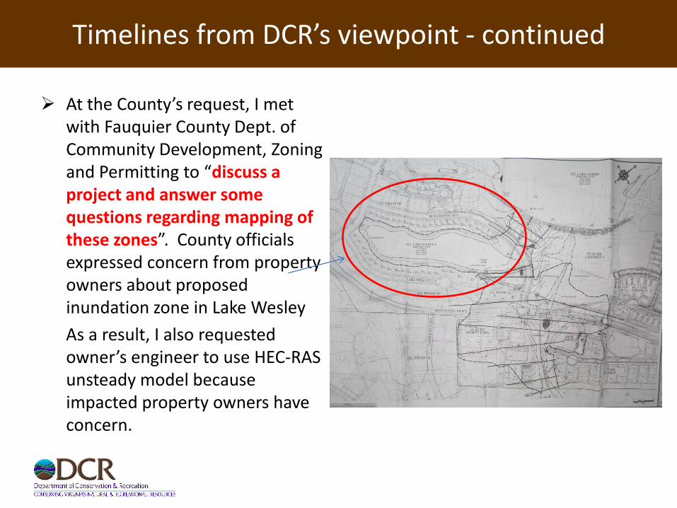
At the County’s request, I met with Fauquier County Dept. of Community Development, Zoning and Permitting to “discuss a project and answer some questions regarding mapping of these zones”. County officials expressed concern from property owners about proposed inundation zone in Lake Wesley
As a result, I also requested owner’s engineer to use HEC-RAS unsteady model because impacted property owners have concern.

Timelines from DCR’s viewpoint - continued
One month later, I met with Fauquier County Dept. of Community Development and County attorney again, total 5~6 officials, at the County’s request. County officials expressed strong concern about proposed inundation zone in Lake Wesley.

Timelines from DCR’s viewpoint - continued
Then I met with owner’s engineers. Engineers wanted to confirm my review comments.
Engineers didn’t understand why I requested HEC-RAS unsteady model. I told them the concern about proposed inundation zone in Lake Wesley from impacted property owners and Fauquier County.
I asked the engineers: “The dam is really flat, and the breach location can be here, or can be there. Why did you choose that breach location, not elsewhere?” Engineers couldn’t give me a defendable reason. At my insist during our meeting, I convinced the engineers and we all agreed that the dam may breach somewhere else other than the chosen location.

Topographic Information – Breach Location #1 is at the proposed emergency spillway
Timelines from DCR’s viewpoint - continued
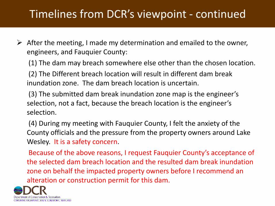
After the meeting, I made my determination and emailed to the owner, engineers, and Fauquier County:
(1) The dam may breach somewhere else other than the chosen location.
(2) The Different breach location will result in different dam break inundation zone. The dam breach location is uncertain.
(3) The submitted dam break inundation zone map is the engineer’s selection, not a fact, because the breach location is the engineer’s selection.
(4) During my meeting with Fauquier County, I felt the anxiety of the County officials and the pressure from the property owners around Lake Wesley. It is a safety concern.
Because of the above reasons, I request Fauquier County’s acceptance of the selected dam breach location and the resulted dam break inundation zone on behalf the impacted property owners before I recommend an alteration or construction permit for this dam.

Follow-ups
• Due to the lack of pursuit on the part of the dam owner/developer, this project has not been progressed further.
• During a meeting with dam owner’s engineer for Lake Anne Dam (#06110) in September 2013, I saw a plan with Lake Wesley not being mapped as dam break inundation zone of Lake Ashby. I was told that the engineer is still in the process of restudying the dam break inundation zones for Lake Ashby Dam (#06152).

Lake Anne Dam, Inventory #06110

Proposed by owner’s engineer: separate Lake Anne into two lakes, consider two dams, and make one or two dams size-exempt from Dam
Safety Regulations.

DCR’s response
• For dam safety purpose, DCR considers Lake Willow and Lake Anne as one lake and one dam.
• The reason is: if two lakes and two dams were considered, both dams should be “L” shape dams, and the potion that separates two lakes would be a shared potion of two dams. If the shared potion of two dams failed at the same time when any other potion of any dam failed, Lake Willow and Lake Anne would share water and become one lake.

Engineer’s decisions, with DCR’s permission, during a meeting in September 2013
• One dam and one lake will be considered for dam safety purpose
• This dam will have two possible breach locations: one to Lake Brittle, another to Lake Ashby. 100% lake water (both Lake Anne and Lake Willow) will go through each breach location to map the dam break inundation zone.
This is similar to FEMA’s floodplain mapping on alluvial fan.
• Both Lake Ashby Dam and Lake Anne Dam will be high hazard dams. Each will have 90% PMP flood spillway capacity.

My recommendation and Fauquier County’s Reply
• Even though not required by Regulations, for the sake of future property owners, I recommend engineers to raise the Lowest Adjacent Grade (LAG) of each new house above the water surface elevation in PMF with a breach.
• Fauquier County Official: “We… will strive to see that the LAG is above the water surface elevation as you recommend”
Lowest Floor (LF) with basement (source: FEMA’s
Lowest Floor Guide)

Lessons learnt
• Breach location of a long dam can determine the inundation zone. The selection of breach location may be the interest of dam owner, developer, impacted property owners, and localities.
• If localities have safety concerns about a dam project including the resulted dam break inundation zone, please tell DCR directly so that DCR knows them.
• Within the gray areas, the better and more communications between DCR and localities, the better service DCR and localities can provide to the public, and the less trouble we would have.
• DCR may need to hold a public hearing if the safety issue associated with Lake Wesley in this construction/alteration permit application still remains – it seems that this problem has been resolved.

Example 3 – At Loudon County’s Request, Developer Brought Quail Ridge Dam into Compliance with State Regulations
• Quail Ridge Dam, #10720, was a low hazard dam without O&M certificate
• Loudon County Requested Owner/Developer to Have O&M Certificate in order to get zoning permits
• As a result, one dam owner (the dam has two owners), who is also the developer, worked very hard with DCR. The other owner, as I was told, “did nothing”.
• The dam is now in the final process to get a regular O&M certificate. It is still a low hazard dam.
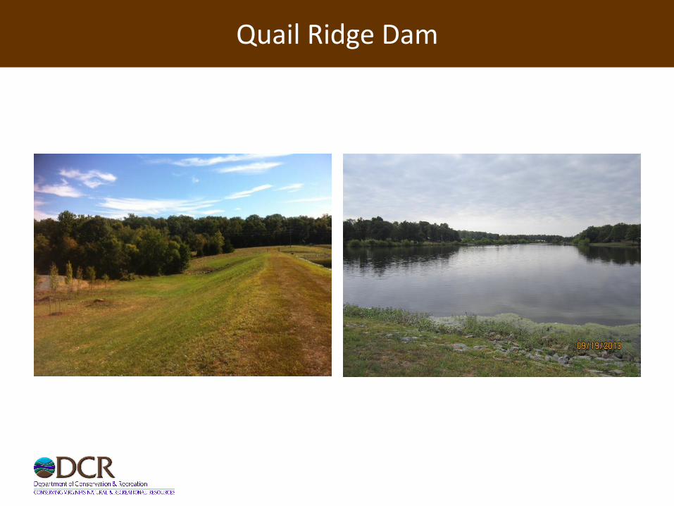
Quail Ridge Dam

Loudon County’s Conditions for Developer/Subdivider
• Zoning permits for Lots xx-xx shall not be issued until the developer/subdivider has acquired a Conditional or Regular Operation and Maintenance Certificate for the Quail Ridge Lake dam
• If it is determined that any portion of a lot is located within the dam break inundation zone, then prior to the sale of that lot the developer/subdivider shall provide disclosure in writing to all prospective purchasers that a portion of the lot is located within the dam break inundation zone, accompanied by a map of the affected area and information pertaining to the Impounding Structure Regulations, including the hazard classification of the dam and associated dam inspection requirements.
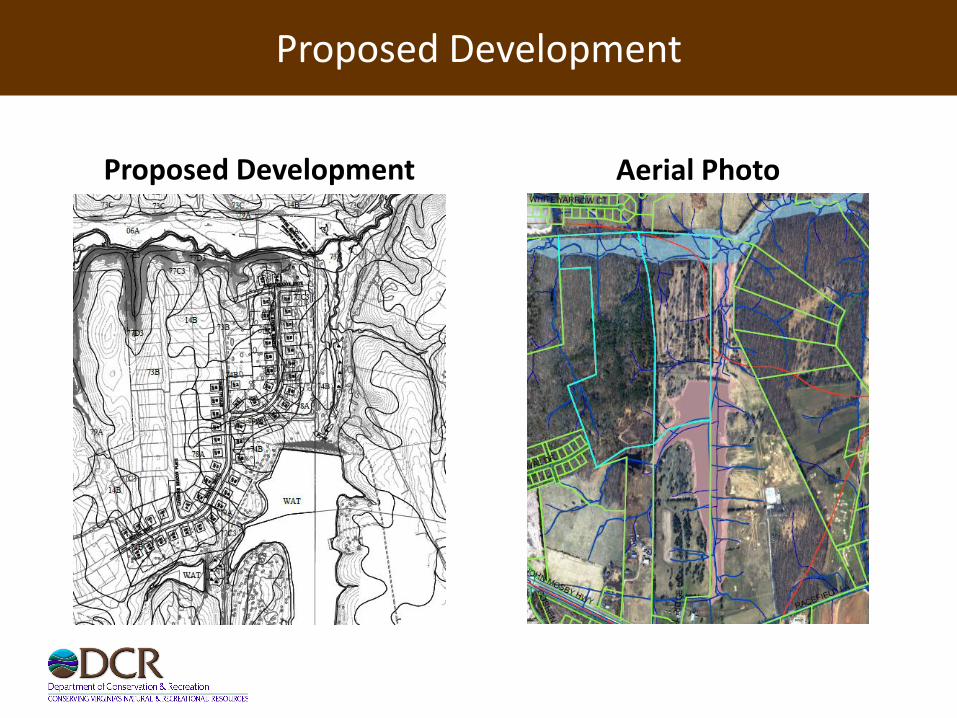
Proposed Development
Proposed Development Aerial Photo

Inundation Zone in PMF with Breach

Inundation Zone in PMF with Breach

Look downstream – the development is leveled up (on the left side)

Comments or questions?
Thank you!