Embed Size (px)
Citation preview
NWP SAF Satellite Application Facility for Numerical Weather Prediction Associate Scientist Mission Report Document NWPSAF-MO-VS-026
Version 2.0
27 June 2005
Implementation Plan for a NRT global ASCAT soil moisture product for NWP Part 2: METOP ASCAT Data Streams and Data Formats
R A Kidd Institute of Photogrammetry and Remote Sensing, Vienna University of Technology, Austria.
0
ASCAT Soil Moisture Report Series No. 2
METOP ASCAT Data Streams and Data Formats
2005 June 27

i
Scope of Document
This document forms the deliverable for the NWP SAF (Numerical Weather Prediction Satellite Application Facility) associate scientist mission Work Package 2, “Data Streams and Data Formats”. This document reports the current understanding and state of the art con-cerning data streams and data formats in relation to the production of near real time soil moisture product from ASCAT data acquired from the METOP suite of satellites. This report collates information from EUMETSAT, ESA and other NWP SAF sources.
The present study was funded by the geoland project (http://www. gmes-geoland.info) and the NWP SAF (http://www.metoffice.com/ research/interproj/nwpsaf).
Status: Issue 2.0
Authors: IPF TU Wien (RAK)
Circulation: IPF, NWP SAF
Amendments:
Issue Date Details Editor Issue 1.0 2005 Feb 11 Initial Document... RAK Issue 1.1 2005 Mar 11 Major edits to document RAK Issue 1.2 2005 Mar 14 Started work on Chapter 6. Passed to WW for
comments. RAK
Issue 1.3 2005 Mar 16 Updated Section 4.2 with Response from EARS Technical Manager
RAK
Issue 1.4 2005 Mar 23 Created section 3.3 in response to WW query on Uploading Data to EUMETCast.
RAK
Issue 1.5 2005 Apr 25 Included overview figures and restructured docu-ment (renamed document to NWP_data_flow)
RAK
Issue 1.6 2005 Apr 27 In draft for comments to WW/KS/ZB RAK Issue 1.7 2005 May 26 Completed sections 1-5 inc. RAK Issue 1.8 2005 May 27 Section 6 and Related Documents complete RAK Issue 1.9 2005 May 27 Applied final formatting ZB Issue 2.0 2005 June 27 Finalised report as work package deliverable RAK
If further corrections are required please contact Richard Kidd. ([email protected]).
ii
Related Documents
In the compilation of this report the following documents and websites have been sourced:
Sourced Documents EPS Programme Documents and Website
• www.eumetsat.int (EUMETSAT Polar System) • ASCAT Products Guide (EUM/OPS-EPS/MAN/04/0028) • ASCAT Level 1 Product Format Specification (EPS/MIS/SPE/97233) • EUMETCast Technical Description (EUM TD 15)
BUFR • WMO Guide (www.wmo.ch/web/www/WDM/Guides/
Guide-binary-1A.html) HDF
• www.ncsa.uiuc.edu Hierarchical Data Format (HDF) home page at the National Center for Supercomputing Applications
Related Documents and Papers
Dragosavac, Milan (2005), BUFR User’s Guide, Operations Department,
ECMWF Technical Notes, EUMETSAT, January 2005.
WMO Manual on Codes, Volume I, International Codes, Part B-Binary
Codes, WMO-No.306, FM 94-IX Ext. BUFR.
Figa-Saldaña, J.; J. J. W. Wilson; E. Attema; R. Gelsthorpe; M. R.
Drinkwater and A. Stoffelen (2002), The Advanced Scatterometer
(ASCAT) on the meteorological operational (METOP) platform: A fol-
low on for European wind scatterometers, Can. J. Remote Sensing,
Vol. 28, No. 3, pp. 404-412.
Gelsthorpe, R. V.; E. Schied; J. J. W. Wilson (2000), ASCAT —
METOP's Advanced Scatterometer, ESA Bulletin Nr. 102, 2000
(esapub.esrin.esa.it/bulletin/bullet102.htm).

iii
Acronym and Abbreviation List
AMSUA Advanced Microwave Sounding Unit (NOAA)
ARGOS Meteorological data collection and location System (DSD)
ATOVS Advanced TIROS Operational Vertical Sounder (suite of sounding instruments includ-ing AMSU-A, AMSU-B and HIRS/3 flown in polar orbit on NOAA - see below - satel-lites)
AVHRR Advanced Very High Resolution Radiometer (for visible and infrared imagery, flown in polar orbit)
BUFR Binary Universal Form for the Representation of meteorological data
CDA Command and Data Acquisition CDA station refers to both the EPS Core Ground Segment station, and the NOAA G/S Station
CGS Core Ground Segment
CHR Commissioning Handover Review
CNES Centre National d'Etudes Spatiale
DCS Data Collection System Instrument
DLM Dynamically Loadable Module
DVB Digital Video Broadcast
DWD Deutscher Wetterdienst
DWDSAT Deutscher Wetterdienst Satellite System
EARS EUMETSAT Advanced Retransmission Service (previously EUMETSAT ATOVS Retransmission Service)
EPS EUMETSAT Polar System
ERS European Remote Sensing Satellite (ESA)
ESA European Space Agency
EUMETCast EUMETSAT's Data Distribution System
EUMETSAT European Organisation for the Exploitation of Meteorological Satellites
FTP File Transfer Protocol
GPP Global Ocean Observing System
GRIB GNSS Receiver for Atmospheric Sounding
GTS Global Telecommunication System (of the WMO)
HDF Hierarchical Data Format
HIRS High resolution Infra-red Sounder
HRIT High Rate Information Transmission
HRPT High Resolution Picture Transmission
IASI Infrared Atmospheric Sounding Interferometer
IDL Interactive Data Language
IJPS Initial Joint Polar System
IPR Intellectual Property Rights
LEO Low Earth Orbit
LRIT Low Rate Information Transmission
MB MegaByte
Mbps Mega Bits per Second
MHS Microwave Humidity Sounder
MSG Meteosat Second Generation
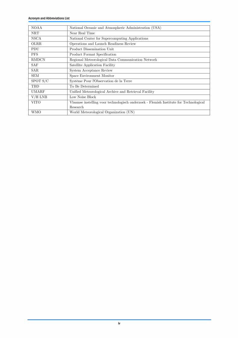
Acronym and Abbreviations List
iv
NOAA National Oceanic and Atmospheric Administration (USA)
NRT Near Real Time
NSCA National Center for Supercomputing Applications
OLRR Operations and Launch Readiness Review
PDU Product Dissemination Unit
PFS Product Format Specification
RMDCN Regional Meteorological Data Communication Network
SAF Satellite Application Facility
SAR System Acceptance Review
SEM Space Environment Monitor
SPOT S/C Système Pour l'Observation de la Terre
TBD To Be Determined
UMARF Unified Meteorological Archive and Retrieval Facility
V/H LNB Low Noise Block
VITO Vlaamse instelling voor technologisch onderzoek - Flemish Institute for Technological Research
WMO World Meteorological Organization (UN)

v
Contents
1 Overview ........................................................................................... 1 2 Introduction to EPS.......................................................................... 3 3 EPS Global Product Distribution and Processing............................. 4
3.1 EPS product dissemination ........................................................ 4 3.1.1 Method 1: Satellite Direct Broadcast Service ........................ 4 3.1.2 Method 2: EUMETCast......................................................... 5 3.1.3 Method 3: GTS/RMDCN ...................................................... 6 3.1.4 Method 4: UMARF, Unified Meteorological Archive and
Retrieval Facility ................................................................... 7 3.2 EPS Pipeline Processing and PDU’s .......................................... 7 3.3 Uploading products to EUMETCast.......................................... 8
4 EPS Regional Products ................................................................... 10 4.1 EUMETSAT ATOVS Retransmission Service ......................... 10 4.2 EUMETSAT Advanced Retransmission Service (EARS) ........ 11
5 Data Formats.................................................................................. 13 5.1 EPS ASCAT format................................................................. 13 5.2 Overview of HDF format ......................................................... 14 5.3 Overview of BUFR format ....................................................... 14 5.4 ASCAT Test Data ................................................................... 15
6 Current Time Lines......................................................................... 16 6.1 EPS .......................................................................................... 16 6.2 EUMETCast ............................................................................ 16 6.3 EUMETSAT Advanced Retransmission Service (EARS) ........ 16 6.4 Reprocessing of ERS-1/2 data.................................................. 16 6.5 BUFR template for Soil Moisture ............................................ 17
Annex 1: EUMETCast Contact Names ............................................... 18 Annex 2: EUMETSAT News Release August 2005 ............................. 19
1
1 Overview
The aim of this document is to provide background information to be used to outline potential solutions concerning the data flow and the set up of TU-Wien’s soil moisture processing chain (WARPNRT Proces-sor). To assess all solutions and provide a final implementation plan (NWP work package 6) it is first necessary to compile an overview of data streams and processes that are currently in place and those ele-ments that are foreseen with the EUMETSAT Polar System (EPS) pro-gramme.
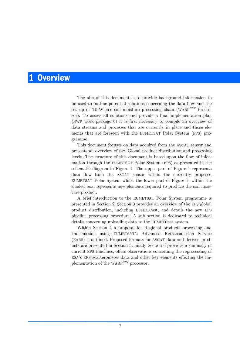
This document focuses on data acquired from the ASCAT sensor and presents an overview of EPS Global product distribution and processing levels. The structure of this document is based upon the flow of infor-mation through the EUMETSAT Polar System (EPS) as presented in the schematic diagram in Figure 1. The upper part of Figure 1 represents data flow from the ASCAT sensor within the currently proposed EUMETSAT Polar System whilst the lower part of Figure 1, within the shaded box, represents new elements required to produce the soil mois-ture product.
A brief introduction to the EUMETSAT Polar System programme is presented in Section 2. Section 3 provides an overview of the EPS global product distribution, including EUMETCast, and details the new EPS pipeline processing procedure. A sub section is dedicated to technical details concerning uploading data to the EUMETCast system.
Within Section 4 a proposal for Regional products processing and transmission using EUMETSAT’s Advanced Retransmission Service (EARS) is outlined. Proposed formats for ASCAT data and derived prod-ucts are presented in Section 5, finally Section 6 provides a summary of current EPS timelines, offers observations concerning the reprocessing of ESA’s ERS scatterometer data and other key elements effecting the im-plementation of the WARPNRT processor.
Overview
2
Figure 1.
Information Flow for the Global Soil Moisture Pro-duct.
3
2 Introduction to EPS
The EUMETSAT Polar System is the European contribution to the Initial Joint Polar System (IJPS) established with NOAA. The IJPS will provide global meteorological and climate data from a series of Euro-pean and American sun-synchronous polar orbiting satellites, compris-ing NOAA N&N and METOP 1 and 2. A further METOP satellite, METOP 3, is part of the EPS, but outside IJPS. Following the commis-sioning of these satellites in a low earth orbit (LEO), they will have a total mission duration expecting to exceed 14 years.
In order to fulfil its contribution EUMETSAT has established co-operation agreements with a number of agencies:
• ESA, for the development and procurement of the three METOP
satellites; • NOAA, for the exchange of instruments, data and operational
cross-support; • CNES, for the provision of IASI and ARGOS-DCS payloads
The EPS mission also includes additional service missions including: • Global Data Access, supporting global scale forecasting by provi-
sion of global data to meteorological and marine services, • Local Data Access, supporting regional forecasting by real time
transmission of data to local reception stations (HRPT and LRPT), • Space Environment Monitoring, supporting routine monitoring of
the charged particle environment of the LEO, • Humanitarian, supporting international Search and Rescue
(S&R) service. Data dissemination was initially envisaged by MSG (Meteosat Sec-
ond Generation) broadcast to HRIT and LRIT user stations, termed near real time, NRT, but a critical failure during commissioning of MSG obliged a revised approach; this lead to the establishment of EUMET-
Cast in 2003. A convergence programme from data distribution via NRT terminals to EUMETCast is in place that will be evident by a ramp-up of the EUMETCast service during the Commissioning phase (launch +6 months) for the operational service and users.
4
3 EPS Global Product Distribution and Processing
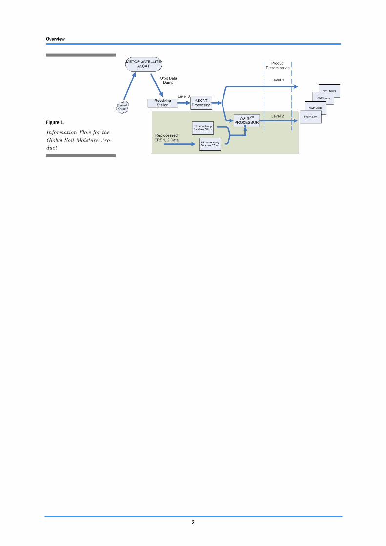
3.1 EPS product dissemination Four methods will be employed by EUMETSAT to disseminate EPS
products and data, as shown schematically in Figure 2. Each of these methods is detailed within the following section.
3.1.1 Method 1: Satellite Direct Broadcast Service
Instrument and ancillary data acquired by the METOP satellites will be broadcast and received by authorised users in real-time via:
• High Resolution Picture Transmission (HRPT) - transmission of
data from all METOP instruments in full resolution; • Low Resolution Picture Transmission (LRPT) - transmission of a
subset of instrument data (AMSUA, MHS, HIRS, SEM and AVHRR Low Resolution).
The data will be received by local, EUMETSAT HRPT/LRPT, reception
stations. The output format of the Reference User Station are Level 0 products in the EPS native format. The broadcast data is encrypted. To
Figure 2.
Data Distribution (based on original schematic © EUMETSAT).
EPS Global Product Distribution and Processing
5
get authorisation to access it, users need to register with the EUMETSAT User Services and will receive the data decryption informa-tion. Most recipients can expect to gather high resolution regional data extending up to about 1500 km radius of the user station.
3.1.2 Method 2: EUMETCast
Global EPS products at different levels will be distributed in near real time via EUMETSAT's Data Distribution System (EUMETCast). EU-
METCast utilises the services of a satellite operator and telecommunica-tions provider to distribute data files using Digital Video Broadcast (DVB) to a wide audience located within the geographical coverage zone which includes most of Europe and certain areas in Africa. The geo-graphic coverage of a DVB is determined by the characteristics of the spacecraft and its associated antenna beams.
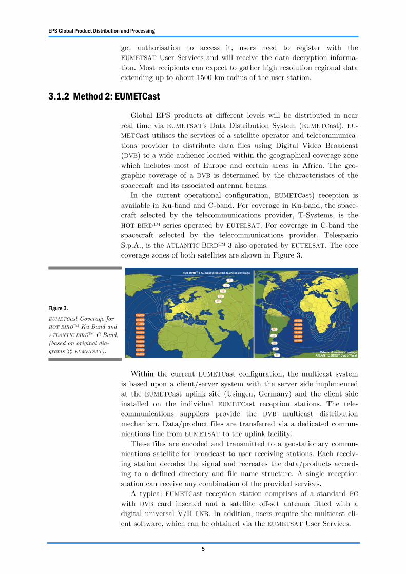
In the current operational configuration, EUMETCast) reception is available in Ku-band and C-band. For coverage in Ku-band, the space-craft selected by the telecommunications provider, T-Systems, is the HOT BIRD™ series operated by EUTELSAT. For coverage in C-band the spacecraft selected by the telecommunications provider, Telespazio S.p.A., is the ATLANTIC BIRD™ 3 also operated by EUTELSAT. The core coverage zones of both satellites are shown in Figure 3.
Within the current EUMETCast configuration, the multicast system is based upon a client/server system with the server side implemented at the EUMETCast uplink site (Usingen, Germany) and the client side installed on the individual EUMETCast reception stations. The tele-communications suppliers provide the DVB multicast distribution mechanism. Data/product files are transferred via a dedicated commu-nications line from EUMETSAT to the uplink facility.
These files are encoded and transmitted to a geostationary commu-nications satellite for broadcast to user receiving stations. Each receiv-ing station decodes the signal and recreates the data/products accord-ing to a defined directory and file name structure. A single reception station can receive any combination of the provided services.
A typical EUMETCast reception station comprises of a standard PC with DVB card inserted and a satellite off-set antenna fitted with a digital universal V/H LNB. In addition, users require the multicast cli-ent software, which can be obtained via the EUMETSAT User Services.
Figure 3.
EUMETCast Coverage for HOT BIRD™ Ku Band and ATLANTIC BIRD™ C Band, (based on original dia-grams © EUMETSAT).
EPS Global Product Distribution and Processing
6
At present (2005 Mar 15), EUMETSAT services available via EUMET-
Cast include Meteosat-8 dissemination, EUMETSAT ATOVS Retransmis-sion Service (EARS) and the Rapid Scanning Service (RSS). The user base was expanded in 2004 from 350 to 850 receiving stations. Products distributed on EUMETCast can be formatted in a variety of formats, in-cluding EPS native format and the WMO formats (BUFR and GRIB).
3.1.3 Method 3: GTS/RMDCN
A subset of EPS products will be disseminated additionally in near real time via the Global Telecommunications System (GTS). GTS is the World Meteorological Organisation integrated network of point-to-point circuits, and multi-point circuits which interconnect meteorologi-cal telecommunication centres. Its purpose is to enable an efficient ex-change of meteorological data and products in a timely and reliable way to meet the needs of World, Regional and National Meteorological Centres. The circuits of the GTS are composed of a combination of ter-restrial and satellite telecommunication links. Meteorological Telecom-munication Centres are responsible for receiving data and relaying it selectively on GTS circuits. The GTS is organized on a three level basis, namely:
• The Main Telecommunication Network, linking together three
World meteorological centres and 15 regional telecommunication hubs.
• The Regional Meteorological Telecommunication Networks, con-sisting of an integrated network of circuits interconnecting mete-orological centres in a region, which are complemented by radio broadcasts where necessary. In Europe, the GTS network is sup-ported by the Regional Meteorological Data Communication Network (RMDCN).
• The National Meteorological Telecommunication Networks, which extend the GTS network down to national level.
Figure 4.
EUMETCast Data Flow (© EUMETSAT).
EPS Global Product Distribution and Processing
7
Products distributed on the GTS are in official WMO formats, namely BUFR and GRIB.
3.1.4 Method 4: UMARF, Unified Meteorological Archive and Retrieval Facility
All EPS products and auxiliary data will be archived and available to users from the EUMETSAT Unified Meteorological Archive and Re-trieval Facility (UMARF) upon request.
The UMARF can be accessed through the EUMETSAT web interface through which the users are able to browse and order products, manage their user profile, retrieve products, documentation and software librar-ies, get help, etc.
UMARF features include geographical and time sub-setting and image preview. EPS products archived in the UMARF can be accessed in a va-riety of formats, including EPS native format and HDF.
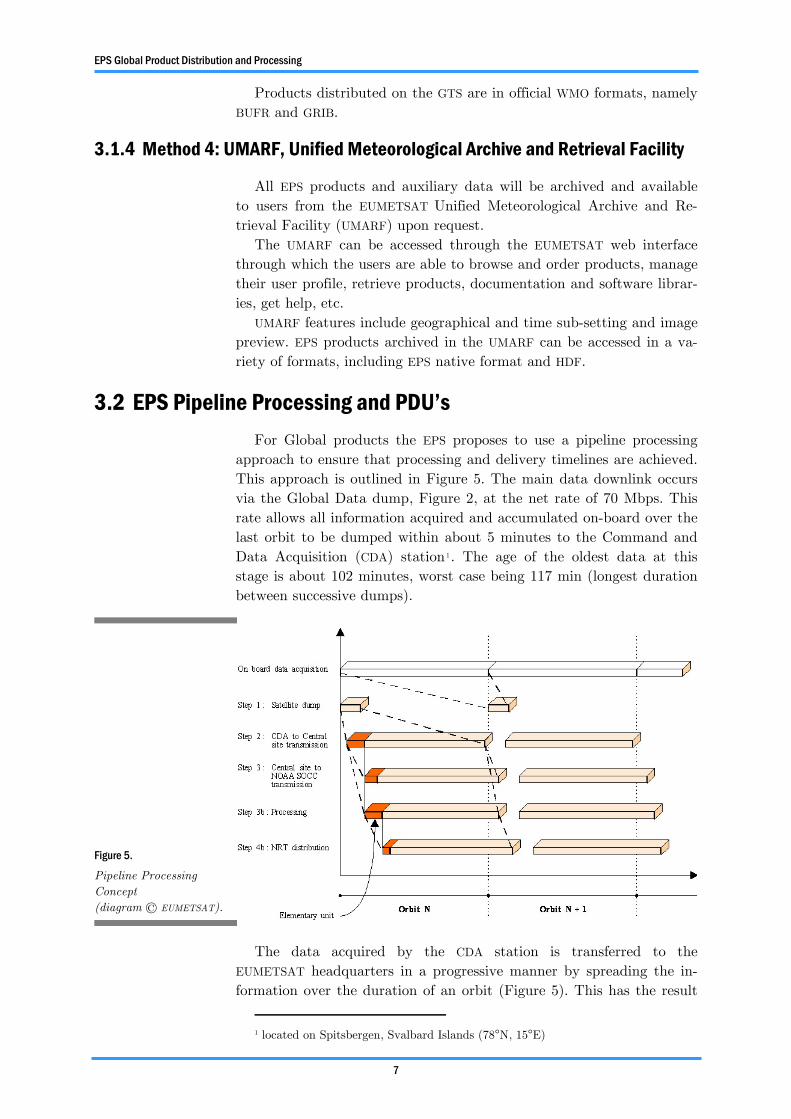
3.2 EPS Pipeline Processing and PDU’s For Global products the EPS proposes to use a pipeline processing
approach to ensure that processing and delivery timelines are achieved. This approach is outlined in Figure 5. The main data downlink occurs via the Global Data dump, Figure 2, at the net rate of 70 Mbps. This rate allows all information acquired and accumulated on-board over the last orbit to be dumped within about 5 minutes to the Command and Data Acquisition (CDA) station1. The age of the oldest data at this stage is about 102 minutes, worst case being 117 min (longest duration between successive dumps).
The data acquired by the CDA station is transferred to the EUMETSAT headquarters in a progressive manner by spreading the in-formation over the duration of an orbit (Figure 5). This has the result
1 located on Spitsbergen, Svalbard Islands (78°N, 15°E)
Figure 5.
Pipeline Processing Concept (diagram © EUMETSAT).
EPS Global Product Distribution and Processing
8
to save considerable communications cost while maintaining a generally constant “age” of data. This progressive transfer continues throughout the processing of the data and the dissemination to the users, meaning that a user can start receiving the product, while the remainder of the data from that orbit is still being transferred to the Headquarters. The data transfer to the GTS/RMDCN also occurs in a progressive manner, but only for a subset of the centrally extracted products and for the SAF products. The UMARF archiving initiates only once the full product is received, making the product available to the users at the latest 7 hours after sensing of the oldest data in the product.
The elementary units in Figure 5 are termed Product Dissemination Units (PDU). The PDUs are shorter than the full length products and contain approximately 3 minutes of observations, as opposed to the 102 to 117 minutes of observations (dump to dump) for a full orbit. The PDUs are not just full products that have been “sliced up”, but are in-dependent fully described entities, therefore a missing PDU does not af-fect other PDUs. PDUs arrive in near real time, approximately at the rate of one per instrument, per processing level, per 3 minutes, and PDUs that do not meet timeliness requirements are not disseminated.
Level 0 and Level 1 products are generated at the Core Ground Segment at EUMETSAT headquarters, whilst level 2 products are gener-ated by the decentralised Satellite Application Facilities (SAF). Level 1b products are radiometerically corrected, calibrated in physical units, and with appended geolocation information.
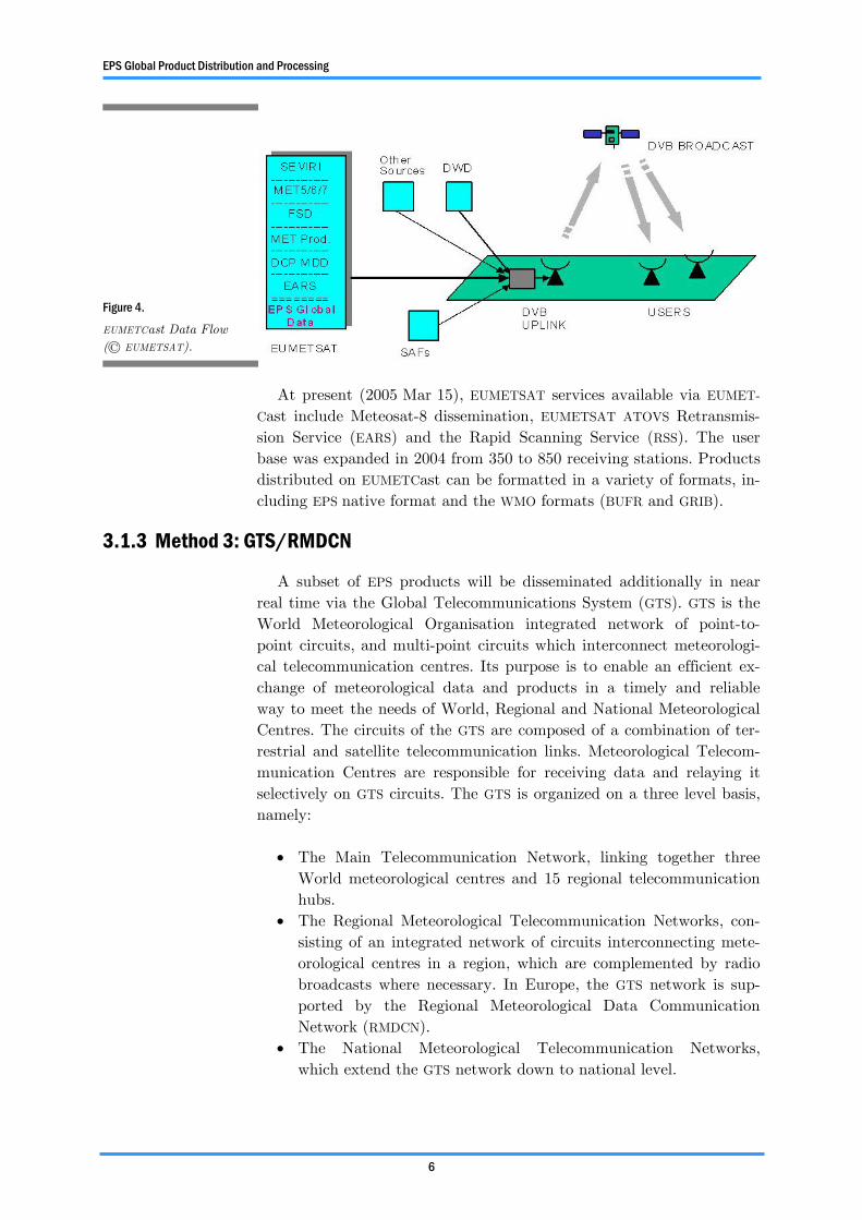
3.3 Uploading products to EUMETCast As noted in Figure 4, there are a number of data providers, apart
from EUMETSAT, who regularly disseminate products to the user com-
1 Maximum Time from Sensing
Table 1.
ASCAT PDU Size.
METOP Level Format Size/PDU (MB) ASCAT SZO Level 1 EPS 0.20
Level 1 BUFR <0.20 ASCAT SZR Level 1 EPS 0.72
Level 1 BUFR <0.72 ASCAT (SAF) Level 2 BUFR TBD
Table 2.
Processing Summary (Summarised for ASCAT).
Level Product Format
Processing Location
Delivery Method
Time From
Sensing1
0 Native EPS User Station LRPT/HRPT Realtime
Core Ground
Segment Broadcast from CDA
117 mins
1b Native/BUFR Core Ground
Segment EUMETCast 135 mins
GTS/RMDCN 135 mins 2 Native/ BUFR SAF EUMETCast 180 mins 2 Native/ BUFR SAF GTS/RMDCN 180 mins

EPS Global Product Distribution and Processing
9
munity via EUMETCast. Currently1, there are two “external” data pro-viders: DWD (Deutscher Wetterdienst , German Meteorological Service) provide DWDSAT data, and VITO (Vlaamse instelling voor technologisch onderzoek, Flemish Institute for Technological Research) provides a “Vegetation Product” generated from an instrument on the SPOT S/C (see news release in Annex 2).
Data providers send their data directly (ftp, internet, or leased line) to a specific directory on the EUMETCast up-link server in Usingen, Germany. Once data is fully received on the service directories of the up-link server it is automatically up-linked and broadcast via EUMET-
Cast to Reception Stations. Potential delays or temporary suspension of broadcast depends upon the scheduling and data priority defined by the data provider and up-link server.
An example of data uplink is provided concerning OSI SAF products from France and Norway: Product sizes: 0.5 to 12 MB; Delta time be-tween reception on up-link server and reception on a EUMETCast Re-ception Station: 0.5 minutes to 12 minutes; Priority: lowest possible - that means, these products do not have stringent timeliness require-ments, and are thus disseminated as “gap-fillers”, which explains the strong variation in dissemination time as function of the higher priority traffic. A better/guaranteed timeliness can be achieved by dissemina-tion scheduling during a “low traffic” period (there are periodic peaks and valleys) or by allocation of a dedicated bandwidth (which might have a cost impact).
The legalities concerning data dissemination are covered by co-operation agreements duly signed between the data provider and EUMETSAT.
1 Personal communications – Schaffner, Dissemination Service Manager, EUMETSAT, 2005 Mar 23

10
4 EPS Regional Products
Under the EPS a new retransmission service is proposed. Based upon the EUMETSAT ATOVS Retransmission Service it will use EUMETCast as its retransmission service. This service will be renamed as EUMETSAT Advanced Retransmission Service (EARS). This service looks towards offering regional (European) coverage and products for ATOVS, AVHRR and ASCAT.
4.1 EUMETSAT ATOVS Retransmission Service Traditionally ATOVS data from the NOAA satellites has been received
via two methods • via the once per orbit data download from the spacecraft to the
central NOAA ground station • via the direct transmission from the satellite to a High Resolution
Picture Transmission (HRPT) station on ground
The first mechanism provides global coverage data to end users, but with delays of three to six hours after the time of measurement. The second mechanism provides the data virtually at the time of meas-
Figure 6.
Northern Hemisphere Coverage for three meth-ods of obtaining NOAA Satellites Instrument Data (figure © EUMETSAT).
EPS Regional Products
11
urement, but the geographical coverage is limited to the region around the HRPT reception station.
The EUMETSAT ATOVS Retransmission Service currently provides improvements on both of these methods by offering a large geographi-cal coverage combined with timely retransmission. This is achieved by
establishing a network of existing HRPT stations around the Atlantic and Arctic Oceans and rapid distribution of the collected instrument data to end users. A network of HRPT stations acquires and processes the NOAA satellite HRPT telemetry data and forwards the generated meteorological products to EUMETSAT. EUMETSAT collects the products and disseminates them to the users via a commercial satellite broadcast service.
4.2 EUMETSAT Advanced Retransmission Service (EARS) Based upon the EUMETSAT ATOVS Retransmission Service, the pro-
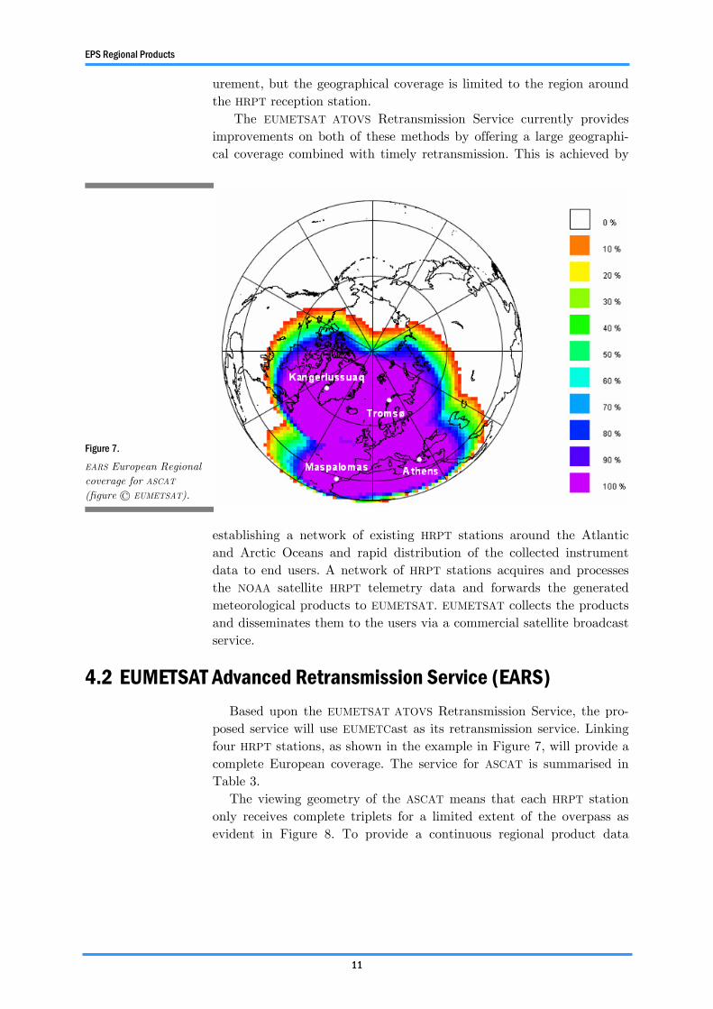
posed service will use EUMETCast as its retransmission service. Linking four HRPT stations, as shown in the example in Figure 7, will provide a complete European coverage. The service for ASCAT is summarised in Table 3.
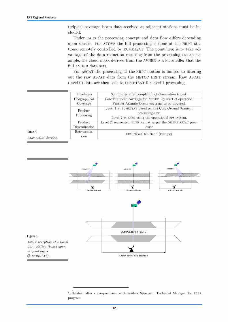
The viewing geometry of the ASCAT means that each HRPT station only receives complete triplets for a limited extent of the overpass as evident in Figure 8. To provide a continuous regional product data
Figure 7.
EARS European Regional coverage for ASCAT (figure © EUMETSAT).
EPS Regional Products
12
(triplet) coverage beam data received at adjacent stations must be in-cluded.
Under EARS the processing concept and data flow differs depending upon sensor1. For ATOVS the full processing is done at the HRPT sta-tions, remotely controlled by EUMETSAT. The point here is to take ad-vantage of the data reduction resulting from the processing (as an ex-ample, the cloud mask derived from the AVHRR is a lot smaller that the full AVHRR data set).
For ASCAT the processing at the HRPT station is limited to filtering out the raw ASCAT data from the METOP HRPT stream. Raw ASCAT (level 0) data are then sent to EUMETSAT for level 1 processing.
1 Clarified after correspondence with Anders Sørensen, Technical Manager for EARS program
Table 3.
EARS ASCAT Service.
Timeliness 30 minutes after completion of observation triplet. Geographical
Coverage Core European coverage for METOP by start of operation.
Further Atlantic Ocean coverage to be targeted.
Product Processing
Level 1 at EUMETSAT based on EPS Core Ground Segment processing s/w.
Level 2 at KNMI using the operational EPS system. Product
Dissemination Level 2, segmented, BUFR format as per the OSI SAF ASCAT proc-
essor Retransmis-
sion EUMETCast Ku-Band (Europe)
Figure 8.
ASCAT reception at a Local HRPT station (based upon original figure © EUMETSAT).
13
5 Data Formats
This section provides brief overviews of relevant data formats and specifically addresses:
• the current EPS ASCAT format; • HDF: a provisional suggestion for the format of the soil moisture
product; • BUFR: the envisaged format for operational dissemination of the
soil moisture product to the to user community. It is apparently common within EUMETSAT to interchange acronyms
of EPS Native Format (or just EPS for short) and PFS as both relate to the Product Format Specification which adheres to a rigorously, well, defined format with specific product versions i.e. the current specifica-tion for ASCAT level 1A/B data is given in version 6.5 and relates to April 2004 baseline.
BUFR refers to the WMO’s Binary Unified FoRmat. As a result of a recommendation from the 27th ASCAT SAG meeting a BUFR template for the soil moisture product will be developed As the administrative ac-ceptance of this (with WMO) may be a lengthy procedure it is suggested that in the within the development phases of the soil moisture process-ing chain the soil moisture product be first produced in a similar self describing format to BUFR, such as the Hierarchical Data Format (HDF).
5.1 EPS ASCAT format The native EPS format, or PFS, for ASCAT adheres to the latest
specifications as given by EUMETSAT. More information on the ASCAT product format can be found in the document “ASCAT Level 1 PFS”, EPS.MIS.SPE.97233, version 6:5.
The format itself will not be described here, but it is important to note that EUMETSAT maintain IDL (Interactive Data Language) proce-dures to read the ASCAT data in the latest PFS. These routines come under a GNU General Public Licence and as such, if integrated into any processing chain, the issue of Intellectual Property Rights (IPR) and software ownership must be addressed.
There also exists software package “ASCAT Level 1b Product Reader” developed within EUMETSAT to read data from ASCAT level 1b
Data Formats
14
products. The software is implemented in C++ and interfaces are pro-vided which allow it to be used by Fortran 90, IDL and Lua programs. This software is available on DVD “EPS Test Data Products and Soft-ware Tools v1.0” Release date: February 10th, 2005.
5.2 Overview of HDF format The Hierarchical Data Format, or HDF, is a multi-object file format
for sharing scientific data in a distributed environment. HDF was cre-ated at the National Center for Supercomputing Applications, NSCA, (http://hdf.ncsa.uiuc.edu/) to serve the needs of diverse groups of sci-entists working on projects in various fields. HDF was designed to ad-dress many requirements for storing scientific data, including:
• Support for the types of data and metadata commonly used by scientists.
• Efficient storage of and access to large data sets. • Platform independence. • Extensibility for future enhancements and compatibility with
other standard formats. HDF data structures are used to describe the primary constructs HDF
provides to store data. These constructs include raster image, palette, scientific data set, annotation, vdata, and vgroup. HDF files are self-describing. The term “self-description” means that, for each HDF data structure in a file, there is comprehensive information about the data and its location in the file. This information is often referred to as metadata. Also, many types of data can be included within an HDF file. For example, it is possible to store symbolic, numerical and graphical data within an HDF file by using appropriate HDF data structures.
Within IDL reading and writing data in HDF is supported. IDL ver-sion 6.1 supports both HDF 4.1r5 and HDF5 5-1.6.1. The later HDF ver-sion uses NSCA C-language library; accessed with IDL via a set of pro-cedures and functions contained in a dynamically loadable module (DLM).
5.3 Overview of BUFR format BUFR format is a rigorously and strictly defined format but has the
advantage that it is “self describing”. The data format is table driven, in that, within each BUFR formatted data set a number of tables are used to give a complete description to the data type and the data loca-tion with the data set.
The key to understanding the power of BUFR is the code's self-descriptive nature. A BUFR “message” (or record, the terms are inter-changeable in this context) containing observational data of any sort also contains a complete description of what those data are: the de-scription includes identifying the parameter in question, (height, tem-perature, pressure, latitude, date and time, whatever), the units, any decimal scaling that may have been employed to change the precision from that of the original units, data compression that may have been
Data Formats
15
applied for efficiency, and the number of binary bits used to contain the numeric value of the observation. This data description is all con-tained in tables which are the major part of the BUFR documentation. (Source: WMO)
The content and structure of these tables are well described in WMO documents and seem straight forward to set up. BUFR formatted data also applies a simple lossless compression technique which means that this format will always be more compact than native EPS format.
A full definition of the BUFR form is given in WMO Manual on Codes, Volume I, International Codes, Part B-Binary Codes, WMO-No. 306, FM 94-IX Ext. BUFR.
5.4 ASCAT Test Data The ASCAT products, provided within the EUMETSAT DVD series
“EPS Test Data Products and Software Tool, v1.0” were produced from synthetic source packets (not realistic data) generated with the ASCAT Ground Processor Prototype (GPP) by ESA/Astrium.
These products are formatted in a modified version of PFS 6.4, see CN26 baseline, and therefore are not in the current April 2004 baseline. However, they can be inspected using either “eugene” or “EPSView” (see software tools on test DVD’s)
A future version of the test data package will contain more up-to-date ASCAT products.
16
6 Current Time Lines
6.1 EPS The following EPS time line was presented by EPS Systems Verifica-
tion and Validation Manager, Dorothee Diebel, at the EUMETCast Dis-semination workshop:
• Up to late Summer 2005: Integration tests by EUMETSAT and by
the Users • Early Autumn 2005: Joint EUMETSAT / User pre-launch V&V
tests • Late Autumn 2005: EPS System Acceptance Review (SAR) • Up to March 2006: Rehearsal phase • March 2006: Operations and Launch Readiness Review (OLRR) • 1 April 2006: METOP launch • April to Sept 2006: Joint EUMETSAT / User in-orbit V&V tests • Oct 2006: Commissioning Handover Review (CHR) • From Oct 2006: Post-commissioning test activities
6.2 EUMETCast EUMETCast is a currently operational system
6.3 EUMETSAT Advanced Retransmission Service (EARS) Based upon the EUMETSAT ATOVS Retransmission Service, the pro-
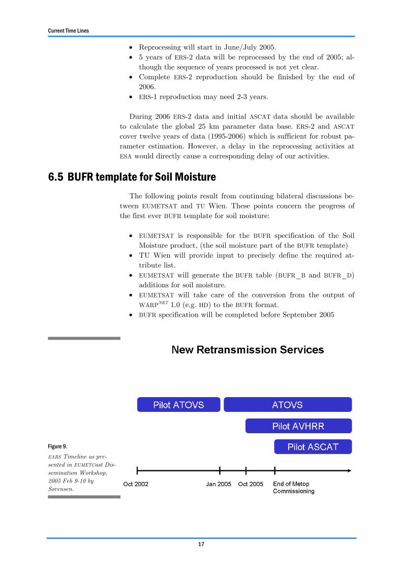
posed service will use EUMETCast as its retransmission service. A time-line is presented in Figure 9.
6.4 Reprocessing of ERS-1/2 data ESA plans to reprocess the entire ERS-1/2 data archive to 25 km.
This new data set is needed as input to WARP 5.0 to calculate the global parameter data base necessary for the NRT processing of ASCAT 25 km image products.
The following points are noted after discussion with ESA/ESRIN (P. Lecomte):
• ESA’s reprocessing system has been in place since spring 2005.
Current Time Lines
17
• Reprocessing will start in June/July 2005. • 5 years of ERS-2 data will be reprocessed by the end of 2005; al-
though the sequence of years processed is not yet clear. • Complete ERS-2 reproduction should be finished by the end of
2006. • ERS-1 reproduction may need 2-3 years. During 2006 ERS-2 data and initial ASCAT data should be available
to calculate the global 25 km parameter data base. ERS-2 and ASCAT cover twelve years of data (1995-2006) which is sufficient for robust pa-rameter estimation. However, a delay in the reprocessing activities at ESA would directly cause a corresponding delay of our activities.
6.5 BUFR template for Soil Moisture The following points result from continuing bilateral discussions be-
tween EUMETSAT and TU Wien. These points concern the progress of the first ever BUFR template for soil moisture:
• EUMETSAT is responsible for the BUFR specification of the Soil
Moisture product, (the soil moisture part of the BUFR template) • TU Wien will provide input to precisely define the required at-
tribute list. • EUMETSAT will generate the BUFR table (BUFR_B and BUFR_D)
additions for soil moisture. • EUMETSAT will take care of the conversion from the output of
WARPNRT 1.0 (e.g. HD) to the BUFR format. • BUFR specification will be completed before September 2005
Figure 9.
EARS Timeline as pre-sented in EUMETCast Dis-semination Workshop, 2005 Feb 9-10 by Sørensen.
18
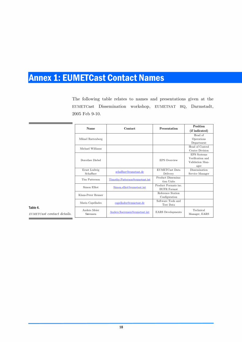
Annex 1: EUMETCast Contact Names
The following table relates to names and presentations given at the
EUMETCast Dissemination workshop, EUMETSAT HQ, Darmstadt,
2005 Feb 9-10.
Table 4.
EUMETCast contact details.
Name Contact Presentation Position
(if indicated)
Mikael Rattenborg Head of
Operations Department
Michael Williams Head of Control Centre Division
Dorothee Diebel EPS Overview
EPS Systems Verification and Validation Man-
ager Ernst Ludwig
Schaffner [email protected]
EUMETCast Data Delivery
Dissemination Service Manager
Tim Patterson [email protected] Product Dissemina-
tion Units
Simon Elliot [email protected] Product Formats inc.
BUFR Format
Klaus-Peter Renner Reference Station
Configuration
Maria Capellades [email protected] Software Tools and
Test Data
Anders Meier Sørensen
[email protected] EARS Developments Technical
Manager, EARS
19
Annex 2: EUMETSAT News Release August 2005
News Release 08/05Communiqué de presse 08/05
European Organisation for the Exploitation of Meteorological Satellites Organisation europeéne pour l'exploitation de satellites météorologiques
EUMETSAT provides support to Flemish Research Institute
EUMETCast to Distribute Vegetation Monitoring Data
Darmstadt, 15 March 2005 – EUMETSAT, the European Organisation for the Exploitation of Meteorological Satellites, and Vito, the Flemish Institute for Technological Research, have completed a series of technical trials in which Vito has been successfully distributing vegetation monitoring data over the EUMETCast data distribution platform.
EUMETCast utilises the services of a satellite operator and telecommunications provider to distribute data files using Digital Video Broadcast (DVB) technology. EUMETCast reaches a wide audience located in Europe, all EUMETSAT Member and Cooperating States and Africa.Talks are ongoing between Vito and EUMETSAT to formalise the use of EUMETCast as a distribution platform with an agreement valid for three years.
“EUMETSAT aims for EUMETCast to be the satellite distribution system of choice for weather, climate and environ-mental data in Europe and Africa. We are pleased with the progress we have made with Vito,” said EUMETSAT Direc-tor-General Dr. Lars Prahm.
Located in Mol, Belgium, Vito is an independent research centre that conducts customer-oriented contract research. It develops products and processes in the fields of energy, environment and materials for both the public and the private sector. Vito’s research is focussed on the development and demonstration of image processing algorithms and associ-ated models using data from both airborne and space borne optical sensors.
Vito’s technical trial with EUMETCast focused on the distribution of vegetation data to agricultural users in Africa. EUMETSAT and Vito worked together to distribute Vito’s data via EUMETCast to one specific receiving station in Nia-mey, Niger.
At present, EUMETSAT services available via EUMETCast include Meteosat-8 dissemination, EUMETSAT ATOVS Re-transmission Service (EARS) and the Rapid Scanning Service (RSS). The user base was expanded in 2004 from 350 to 850 receiving stations.
Vito cooperates with the Joint Research Centre of the European Commission, and this cooperation could lead to further Vito data products being distributed via EUMETCast.
EUMETSAT
Annex 2
20
The European Organisation for the Exploitation of Meteorological Satellites, is an intergovernmental organisation that establishes and maintains operational meteorological satellites for 18 European States (Austria, Belgium, Denmark, Finland, France, Germany, Greece, Ireland, Italy, Luxembourg, the Netherlands, Norway, Portugal, Spain, Sweden, Switzerland, Turkey and the United Kingdom). EUMETSAT has signed 11 Cooperating State Agreements. Those with Croatia, Hungary, Latvia, Lithuania, Poland, Romania, Slovakia and Slovenia have entered into force whereas the Agreements with Bulgaria, the Czech Republic and Serbia and Montenegro are to be ratified in the near future.
EUMETSAT is currently operating Meteosat-6, 7 and 8 over Europe and Africa, and Meteosat-5 over the Indian Ocean.
The data, product and services from EUMETSAT’s satellites make a significant contribution to weather forecasting and to the monitoring of the global climate.
Am Kavalleriesand 31 D-64295 Darmstadt Germany
Contact:
Media Relations EUMETSATLivia BRIESE
Communications ManagerPhone: +49 6151 807 839
General Media Enquiries EUMETSATAnne TAUBE
International Relations and Communications AssistantPhone: +49 6151 807 419
E-mail: [email protected]: www.eumetsat.intFax: +49 6151 807 866