Embed Size (px)
Citation preview

Impacts on environmental law and regulations on agricultural land-use change and urban
pressure: the Algarve case
Abstract
Land-use change has been an increasing concern in most of Europe. While stakeholder’s
strategies of coping with land-use change have been constrained mainly due to socio-
economic pressures, the natural landscape and fragile ecosystems are neglected by heavy
construction and urbanization. However, over the last thirty years regulations have
become more explicit regarding environmental impacts at regional level. Spatial
assessment of ongoing policies of rural and urban have led in the case of Portugal to
some reservations on the consequences of sustainable development and juridical
commitment. A good example of this is the agricultural land loss that Portugal has
witnessed over the last thirty years, in large part resulting from socio-economic pressures
with which policymakers have not been able to cope.
The Reserva Agrícola Nacional (RAN transl. National Agricultural Reserve) may be
identified as an instrument of planning purposes that identifies and protects the areas
prone to agricultural activities due to their morphological, climatic and social context.
The RAN has changed its legal status over four times in the last twenty years. These
changes have in large been influenced by the policies of sustainable development for the
region. However, the ability to defend the interests of agricultural and rural commitments
in fragile ecosystems has been largely compromised due to socio-economic interactions
brought by pressures of economic growth.
Dynamic and statistical modeling approaches may allow a sharper understanding of the
consequences of preemption of agricultural land in the Algarve. The spatial properties of
data inventories from the RAN and land-covers, allow to assess the changes within the
policy context of the Algarve.
An integrated assessment of agricultural land loss compared with urban growth
parameters, unfolds into a rich laboratory of spatio-temporal analysis of carrying capacity
of the regional / rural environment.

2
By approaching a spatial analysis of preemption of agricultural land with overlay of
population and urban data, a focus o the consequences of the certain regulations with the
dynamics of land-use change become possible.
While this paper expands further on the actual existing decrees which offer support to
sustainable development in the region, a qualitative assessment of future roles of ethical
values and economic efficiency, while offering a constructive position for policy makers
regarding the trends of urban / agricultural dichotomy are analyzed.

3
1. Introduction
Environmental regulation is one of the most fundamental aspects for competitiveness,
allowing to reduce cost for industry and business, generate new markets for
environmental goods and services, create jobs as well as protect and sustain natural
resources from scarcity (Network of Heads of European Environment Protection
Agencies, 2005). That said, environmental law which abridges the Environmental law
system, may be defined as “an organized way of using all of the laws in our legal system
to minimize, prevent, punish, or remedy the consequences of actions which damage or
threaten the environment, public health, and safety.(p. 4)” (Steinway and Botts, 2007).
However, from a strictly anthropocentric perspective, the very core of legislation of
environmental issues is overshadowed by the interests in economic growth. The
importance of seeing sustainable development as an interconnected reality, where just
distribution of resources should exist and in which irreversible options must be handled
with care (Gladwin et al, 1995) is often forgotten . Thus, environmental regulation is
often overthrown to economic externalities, making efficient regulation often a disputable
topic between the paradigm of growth and sustainability. This has especially been
witnessed in the last decades, where environmental deterioration and increasing
economic growth have brought scarcity to certain ecological sectors, such as agriculture
and have led to increasing asymmetries.
An attempt to “minimize the consequences on environment” (Steinway and Botts, 2007)
becomes a very difficult task, calling for regional decrees which legislate and articulate
the policies of sustainable development and environmental change, facing the paradigm
of socio-economic growth. These decrees however, are often restructured and
reorganized to fit the current aspects of environmental degradation, lacking as a
consequence a stable and continuous monitoring of sustainability.
Environmental degradation caused by human pressure has been witnessed in different
regions of the world. In Europe, where a strong legislation and a good juridical system in
general does prevail, urban sprawl has been an inevitable reality. Brought by population
increase and socio-economic growth, significant land abandonment especially in regions
with a higher demand of tertiary sector activities have been witnessed. Environmental

4
regulation however, has not been able to solve this problem, and, taking as an example
theAlgarve in Portugal, such pressures have directly been responsible for the destruction
of fragile ecosystems, loss of agricultural land and coastal vulnerability.
Coastal regions share a twofold problem for policy making: there location as socio-
economic system, correspond to highly productive regions which are by far too complex
to allow a linear analysis for policy making (EEA, 2006). On the other side, the
productive cycle of such areas relies heavily on ecosystems functionality which may
become jeopardized with excessive exploration of goods and services. From a historic
perspective, coastal areas have been the cradle for a panoply of resources such as
agriculture, leading to settling patterns which have encouraged regional prosperity. Their
unique landscape combines often moderate temperatures with historico-cultural character
which have also led to development of tourist industries in such areas (Vaz and Nijkamp,
2009). However, excessive growth leads to a deterioration of coastal areas, compromising
the resilience of such regions. At the long run, ecosystem services of littoral regions must
be carefully planned not to jeopardize the fragile ecological habitats in such areas
(Costanza et al, 1997).
The issue becomes one of resilience of environmental carrying capacity to support the
demand of economic growth. While for example, tourism may be a beneficial activity to
some extend (Lacitignola et al, 2007), bringing jobs to certain coastal basins, the
counterpart is of rapid land deterioration brought by seasonal population pressure
(Kruger, 2005).
The synergistic relation between economic growth and sustainable development is a very
complex one, as the effects of socio-economic growth influence the system (or region) in
a non-linearly. The dynamics of non-linear complex systems are very difficult to cope
with, making necessary legislation to be cross-dimensional. However, such
environmental legislation share the less decision-making influence, while narrow focused
environmental laws have a larger impact (Ruhl, 1999), as there extend of application is
more pragmatic.

5
2. Spatial information and complexity
Spatial analysis has been largely motivated by different scientific backgrounds, such as
geography, statistics, economics and mathematics. Complex systems, although still
lacking a consensus regarding its definition, has allowed to create structural analysis of
combined factors of economic and social and natural drivers (see Newman, 2005). One of
the main advantages of complex systems analysis resides in the possibility of a
integrative approach of understanding the global consequences of interactions (Taylor,
2005). The applicability of spatial information and higher spatial resolution
georeferenced economic, social and environmental strata, allows a much more coherent
approach to integrative analysis: Social, Economical and Environmental phenomena
happen in a specific space and time. By combining different factors from heterogeneous
variables along a territorial unit over time, it becomes possible to find a coherent
explanation of key drivers for environmental change, leading to a better approximation of
sustainable development.
The cross-linkage of policy decisions implies direct impact on land-use and on territorial
management. Spatial information and complex systems may, if combined correctly create
accountable approaches of land-use change and support in identifying key drivers for
certain land-use changes. This information permits a much more accurate approach to
decision making and of understanding relevant constraints for sustainable development
(Nijkamp and Scholten, 1993).
3. The Study Area

6
Located at the south of Portugal, the region of the Algarve is one of the most well known
regions of Portugal for its prosperous and active tourism sector. The region itself shares a
unique historico-cultural legacy brought by the Phoenician, Roman and Moorish
influence.
The coastal area of the Algarve, has a unique ecological landscape, integrated in the
continental network of conservation habitats, defined under the European Union
directives: 79/409/CEE of the 2nd April and 92/43/CEE.
While the geomorphology of the Algarve may be delimited into three different regions:
the Interior, Barrocal and Litoral. The Algarve shows a significant asymmetry between
the Interior (located at the northern perimeter of the region) and the Litoral (the coastal
regions of the Algarve). It is within the coastal region that areas tend to be more fertile,
and converging ecosystems in the southeast area create the unique Reserva Natural da
Ria Formosa, known for many different types of edaphic species.
The figure below (Fig. 1) shows the geographical region of the Algarve, as well as the
integration of the NATURA 2000 network. However, the increasing asymmetries
between population increase in the south of the Algarve contrary to the northern
perimeter, jeopardize the important ecosystems and put at risk the agenda of development
of rural areas.

7
Figure 1 - Municipalities and territorial limits of protected areas in the Algarve (CCDR Algarve)
While agricultural activity has been high in the Barrocal, specializing in carob
production, and in the Interior, ranging from ovine production and other agro-pastoral
activities (Assunção, 1989) the Litoral has lost largely its agricultural sector for
exploration of tourism activities. Since the sixties an increase of tourism brought by low-
cost flights throughout Europe have been seen as an opportunity of economic growth and
prosperity for the region. Creation of amenities and infrastructures to support a massive
tourism industry, changed primary sector activities to a tertiary sector, focusing
predominantly on the service sector related to tourism.
The development of the tourist industry provided better job opportunities, attracting a
massive concentration of population in the Algarve, contributing directly to coastal
population increase. The figure below (Fig. 2) represents the population growth tendency
0
50000
100000
150000
200000
250000
300000
350000
400000
450000
500000
1700 1750 1800 1850 1900 1950 2000 2050
Figure 2 - Population growth in the Algarve since the XVII century
since mid XVII century. The exponential growth that the Algarve has witnessed, has
especially increased during the eighties, and is a reflection of the mass tourism industry.
8
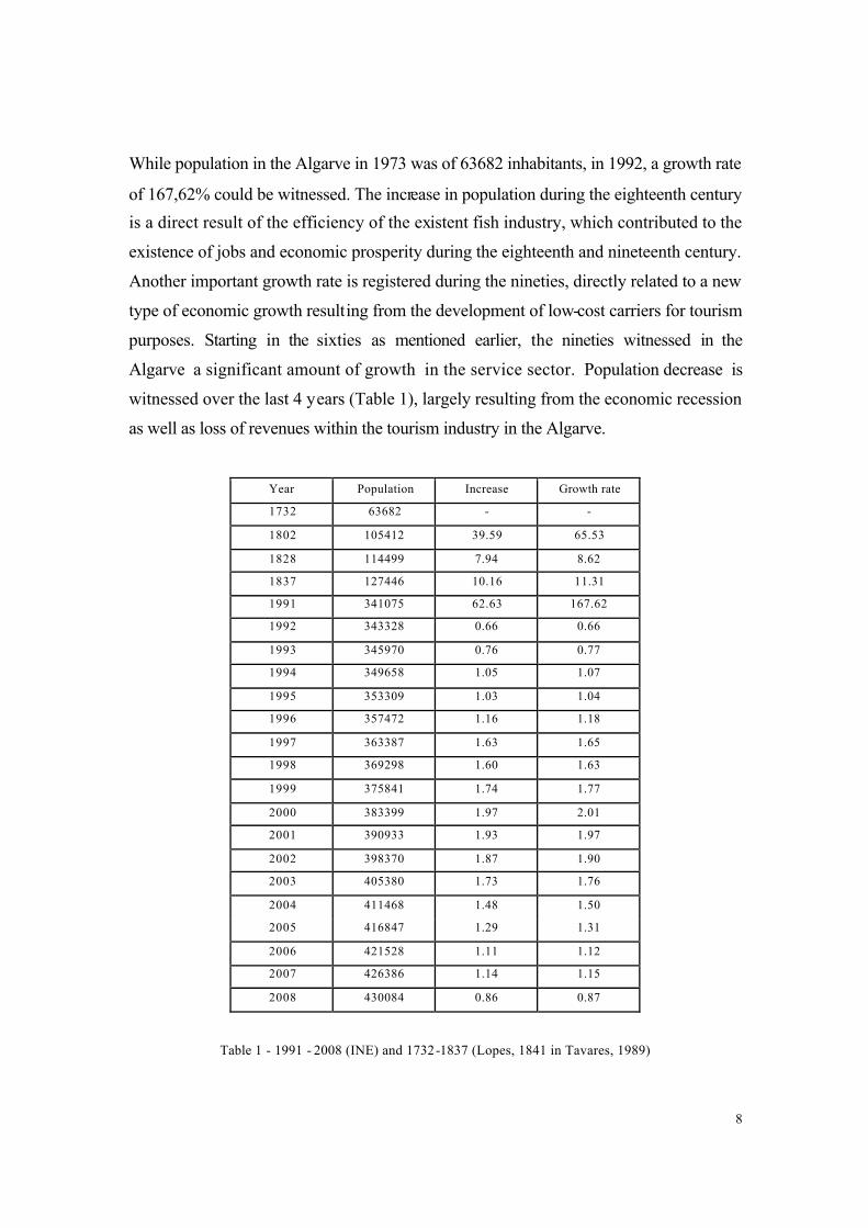
While population in the Algarve in 1973 was of 63682 inhabitants, in 1992, a growth rate
of 167,62% could be witnessed. The increase in population during the eighteenth century
is a direct result of the efficiency of the existent fish industry, which contributed to the
existence of jobs and economic prosperity during the eighteenth and nineteenth century.
Another important growth rate is registered during the nineties, directly related to a new
type of economic growth resulting from the development of low-cost carriers for tourism
purposes. Starting in the sixties as mentioned earlier, the nineties witnessed in the
Algarve a significant amount of growth in the service sector. Population decrease is
witnessed over the last 4 years (Table 1), largely resulting from the economic recession
as well as loss of revenues within the tourism industry in the Algarve.
Year Population Increase Growth rate
1732 63682 - -
1802 105412 39.59 65.53
1828 114499 7.94 8.62
1837 127446 10.16 11.31
1991 341075 62.63 167.62
1992 343328 0.66 0.66
1993 345970 0.76 0.77
1994 349658 1.05 1.07
1995 353309 1.03 1.04
1996 357472 1.16 1.18
1997 363387 1.63 1.65
1998 369298 1.60 1.63
1999 375841 1.74 1.77
2000 383399 1.97 2.01
2001 390933 1.93 1.97
2002 398370 1.87 1.90
2003 405380 1.73 1.76
2004 411468 1.48 1.50
2005 416847 1.29 1.31
2006 421528 1.11 1.12
2007 426386 1.14 1.15
2008 430084 0.86 0.87
Table 1 - 1991 - 2008 (INE) and 1732-1837 (Lopes, 1841 in Tavares, 1989)

9
The construction of the International Airport in the capital district of Faro, as well as the
ongoing options on coastal tourism, have allowed the tertiary sector to prosper, while
neglecting the primary sector activity contributing for city expansion into fertile reg ions.
As suggested by Wrigley (1985), rise of incomes elasticity for food is less than unit
necessarily secondary and tertiary sectors are prone to prosper. The consequence
however, may be devastating for ecological coastal regions given the depletion of
important resources. Furthermore In 2008, the region of the Algarve showed a density of
approximately 80 inhabitants per km2. The asymmetry between the coastal area and the
northern region of the Algarve, make a much larger variation of density estimates,
contributed by the disparity during summer, where the region triples its size of
inhabitants, clustering in the regions of prolific tertiary sector activities. The figure below
(Fig. 3), shows the population density per parish, reflecting clearly the cluster pattern on
coastal areas and lower intensity in the interior.
Figure 3 - Population density per Parish
A predominant pattern of population density is visible in the surroundings of Faro, the
districts capital of the Algarve, as well as in the areas of Albufeira, Portimão and Vila
Real de Santo António.

10
4. Data and Methodology
This study is centered around the changes of Portuguese legislation since the end of the
nineties until now, regarding the peri-urban and agricultural areas of the south coast of
Portugal - the Algarve. The depletion of rural areas that the Algarve has witnessed in the
last decades is aggravating and may provoke scarcity in the region. Loss of natural
habitats and biodiversity are an increasing concern for regional policymakers as well as
widely recognized in the Municipal Plans of the Algarve.
Methodologically, the main objective of this study is to create comparable spatial datasets
derived from land-use maps regarding urban land-use and cross-link with agricultural
preemption loss in the Municipalities of the Algarve.
Thus, this study proposes a land-use accounting methodology which is shared with
population density dynamics and urban growth variations for similar time frames. This
accounting methodology shall allow recognizing the main driver for agricultural land loss
- whether urban growth may be considered as a significative driver for loss of rural areas,
or, on the other hand, systemic population increase might be a key driver of agricultural
land preemption. A multi-temporal analysis for the decades of the nineties and 2000,
allows to create variation for urban areas as well as agricultural areas. These dynamics
are registered as urban variations and agricultural preemption variations and assessed
with the profile of population density. The impact of this analysis (Fig. 4) leads to an
assertive characterization of the responsible driver, as well as hypothetical evaluation of
future trends regarding agricultural land use and population density for the region of the
Algarve. This qualitative analysis combined with the quantitative support from spatial
data, permits a better understanding of the dynamics of sustainable development,
considering that urban growth is an inevitable reality but sustainable cities must be taken
into account also.

11
Figure 4 - Flow diagram of Methodology
The comparison of both realities of loss of agricultural land from land loss protocols with
urban growth, will allow to establish a regression growth from spatial strata.
shows the workflow of the comparison of the CORINE Land Cover period for 90, 2000
and 2006 with the growth agricultural land surveys collected since 1991 to 2008. Given
the change analysis of the CLC periods, urban areas and agricultural areas are mutually
assessed to examine land-use change. Diagnosis of population growth and preemption of
agricultural land are reported within the directives of regulation frameworks between
1989 and 2008. The strategies for the National and Ecological Reserve and for the
National Agricultural Reserve are remitted to the existent policies, justifying the available
carrying capacity to understand the pressure of population tendencies for 2020 and
agricultural tendencies for 2020. These Drivers are tested based on linear regression and
forecasted to form the current critic to the endangerment for sustainable development for

12
the region. The multiple time series of population, urban quantification, agricultural
quantification and preemption of agricultural land as well as regression correlations allow
a comparison of land loss and socio-economic driving forces. The result of this
quantification shall mitigate impacts on urban pressure on the coastal region of the
Algarve, as well as recognize the ongoing juridic importance of quantitative spatial
analysis within the notions of land preemption for urbanization.
The CORINE Land Cover project (CLC) may be considered as a first attempt of deriving
spatial information of land-use under the European umbrella.
Starting on the 27th June 1985, as a program that would address the following issues:
State of individual environments, Geographical distribution and state of natural areas,
Geographical distribution and abundance of wild fauna and flora, Quality and abundance
of water resources, Land cover structure and the state of the soil, Quantities of toxic
substances discharged into environments and List Natural Hazards (EEA, 1995). In this
sense, CLC can be seen as an 'an experimental project for gathering, coordinating and
ensuring the consistency of information on the state of the environment and natural
resources in the Community' (85/338/EEC, Council Decision 27/6/1985 ).
The RAN is a Portuguese tool for territorial management, corresponding to the number of
areas which, due to their morphologic, climatic and social conditions are adequate and
share the most potential for development of agricultural activities. Essentially, the areas
combined within the Reserva Agrícola Nacional are more fertile, and thus, have a larger
tendency for creating urban-use patterns. However, local patterns of agricultural activity,
typical in the rural areas of the Algarve become depleted from their traditional positive
externalities, leading to an augmentation of negative externalities brought by non-
systemic production sectors. This led in 1976 to the “Law of Land-use” (Decreto Lei n.
794/76, 5th November), bringing policies of urban control, and prospection of
agricultural activity. However, urban and population pressure as well as existent
concentration on secondary and tertiary sector lead to further agricultural abandonment,
and unavoidable urbanization patterns in Portugal. A especial framework of legislation
was conceived in 1982, which shared the concerns of agricultural land loss, creating the
RAN (Decreto Lei n. 451/82, 16th November), with the main objective of recovering lost
agricultural and abandoned land.

13
The Reserva Agrícola Nacional is divided in two distinct classes (A and B), based on
physical and geographical characteristics (Decreto Lei n. 196/89, 14th June). RAN land
is systematically decreasing, while urban areas register a steady increase (Fig. 5).
Figure 5 - Comparison of urban growth and RAN land
A closer analysis of land preemption over the last decades shows a fluctuating pattern
especially felt since 1996 (Fig. 6). Strongly linked to existent land-use policies, the
preemption patterns show an increase since 1994 and in 2005 register the most significant
preemption of RAN land, with a total of 3722864 m2 lost.

14
Figure 6 - Evolution of agricultural land preemption
This pattern is of increasing concern, given the fluctuation nature of land preemption and
the increasing trend-line of loss of agricultural land. While the peak is for now registered
in 2005, it seems to be expected that, with the current trend registered over the last
decade and a half, that one might expect a further increase of an equal peak as registered
in 2003 for land preemption in 2010. A closer analysis of urban growth tendencies for the
Algarve region as analyzed by Vaz and others (2009), show the overburdening tendency
of agricultural land loss due to urban pressure.
Analysis of urban growth patterns between the nineties and 2006 demonstrate a
continuous growth along all of the Municipalities (Table 1).

15
Table 2 - Ratio of urban variation from CLC 90 to CLC 06 in pixels
Although all municipalities registered significant increase over the 15 years of study, a
clear increase in urban sprawl has been verified in Castro Marim, Alcoutim and Silves.
Curiously, this areas have had a long tradition regarding the agricultural sector in the
Algarve, and have been subjected quite rapidly to urban growth. A further analysis on
population density patterns in the Algarve, also reflecting this increase, may be a direct
result of competitive prices for construction as well as existing road-networks that allow
communication to important cities such as Faro, Portimão and Albufeira.
5. Conclusions
5.1. Urban growth and Agricultural land loss
A comparative analysis of existing land-use patterns regarding preemption of
Agricultural land, allowed to compare the results of urban variation per municipality with
variation of loss of RAN. The results were quite intriguing: While population density

16
does not seem to show a direct consequence on urbanization patterns, loss of RAN shares
a similar structure of behavior as urban land variation. This information is of utmost
interest, as it shows an overall tendency of agricultural land changing to urban areas.
This is especially felt in Alcoutim and Silves, where agricultural production has been
traditionally high, and current urban growth is following the tendencies of construction
among peri-urban areas.
Figure 7 - Examples of urban growth in Alcoutim and Silves
Datasets of RAN were summed to the same timeframes as CLC data and information
were cross-linked. the result showed that Alcoutim, Monchique and Silves, on the top of
urban growth, also showed explicit loss of agricultural land through preemption of
Agricultural regulation of the Reserva Agrícola Nacional. While at local level this
information is not evident, a regional quantification of variations of RAN and urban areas
share crucial information of land-change patterns for the Algarve.
A larger framework of study for Portugal, using the CORINE Land Cover datasets also
allowed to confirm that, in the case of Portuguese land-use change, Agricultural land has
a tendency to change to urban areas. While this acknowledgement is quite obvious, the
Algarve shows an increasing tendency of land preemption, with an increasing propensity
of urban growth along the preempted lands. This pattern seems to be shared with a
fluctuating tendency of policies along the areas which allow preemption of agricultural
17
land during certain years (2000, 2003 and 2005), while this preemptions are mainly
linked to important regional activities such as, for example, the Euro 2004.
The economic prosperity brought by the Tourist industry, have fomented the strategy of
creation of infra-structures within the Algarve. Within the concept that currently
promotes the Algarve as a sun and beach district - the “Allgarve” - preemption of
agricultural land has led to the an unavoidable land-loss of agricultural territory,
especially in peri-urban perimeters. The environmental consequences of this growth are
evident: traditional agricultural soils have diminished widely, while new infra-structures
seem to boost around certain central areas along the coastal regions.
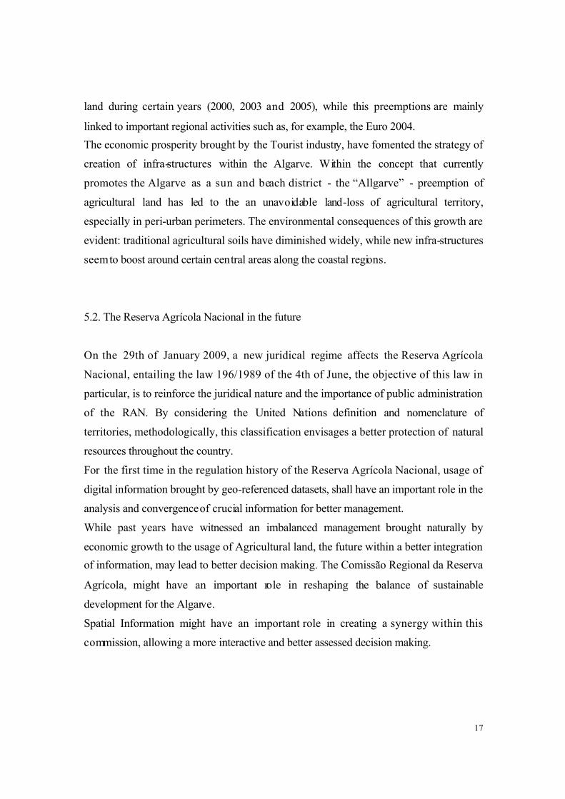
5.2. The Reserva Agrícola Nacional in the future
On the 29th of January 2009, a new juridical regime affects the Reserva Agrícola
Nacional, entailing the law 196/1989 of the 4th of June, the objective of this law in
particular, is to reinforce the juridical nature and the importance of public administration
of the RAN. By considering the United Nations definition and nomenclature of
territories, methodologically, this classification envisages a better protection of natural
resources throughout the country.
For the first time in the regulation history of the Reserva Agrícola Nacional, usage of
digital information brought by geo-referenced datasets, shall have an important role in the
analysis and convergence of crucial information for better management.
While past years have witnessed an imbalanced management brought naturally by
economic growth to the usage of Agricultural land, the future within a better integration
of information, may lead to better decision making. The Comissão Regional da Reserva
Agrícola, might have an important role in reshaping the balance of sustainable
development for the Algarve.
Spatial Information might have an important role in creating a synergy within this
commission, allowing a more interactive and better assessed decision making.
18
References
Gladwin, T.N; Kennelly, J. J.; Krause, T-S., Shifting Paradigms for sustainable
development: implications for management theory and research, Academy of
Management Review, 20(4), pp. 874-907.
Assunção, J. P., 1989, A Influência dos Factores Ecologicos e Humanos na Evolução da
Agricultura Algarvia, O Algarve - Na perspectiva da Antropologia Ecológica, pp. 271-
290.
Donoghue, D. N. M, 2002, Remote sensing: environmental change, Progress in Physical
Greography, 26(1), pp. 144-151.
Ruhl, J. B., 1999, Sustainable Development: A Five Dimensional Algorithm for
Environmental Law, Stanford Environmental Law Journal, 18(31), pp. 31-64.
Wrigley, E. A., 1985, Urban Growth and Agricultural Change: England and the
Continent in the Early Modern Period, Journal of Interdisciplinary History, 15(4), pp.
683-728.
Network of Heads of European Environment Protection Agencies, 2005, The contribution
of Good Environmental Regulation to Competitiveness, European Environmental
Agency. (url: http://www.eea.europa.eu/highlights/Ann1132149255, consulted on: 22nd
December 2009).

19
Steinway, D. M., 2007, Fundamentals of Environmental Law, in Environmental Law
Handbook, 19th edition, ed: Sullivan, T., pp. 1-66.
Newman, L. (2005) Uncertainty, innovation, and dynamic sustainable development.
Sustainability: Science, Practice, & Policy, 1(2).
Taylor, P. J. (2005) Unruly complexity: Ecology, interpretation, engagement, Chicago:
The University of Chicago Press.
Newton, A., Icely, J. D., Falcao, M., Nobre, A., Nunes, J. P., Ferreira, J. G., et al. (2003).
Evaluation of eutrophication in the ria formosa coastal lagoon, portugal. Continental
Shelf Research, 23(17-19), 1945-1961.
EEA (European Environmental Agency), The changing faces of Europe’s coastal areas,
Report 8/2006. (url: http://www.eea.europa.eu/publications/eea_report_2006_6,
consulted on: 2nd January 2009).
Costanza, R.; D’Arge, R.; de Groot, R; Farber, S.; Grasso, M.; Hannon, B.; Limburg, K.;
Naeem, S.; O’Neill, R. V.; Paruelo, J.; Raskin, R. G.; Sutton, P.; van den Belt, M.,
(1997), The vale of the world’s ecosystem services and natural capital, Nature, 387,
pp. 253-260.
Lacitignola, D.; Petrosillo, I.; Cataldi, M.; Zurlini, G., 2007, Modelling socio -ecological
tourism-based systems for sustainability, Ecological Modelling, 206, pp.196-204.
Kruger, O., 2005, The role of ecotourism in conservation: panacea or Pandora’s box?,
Biodiversity and Conservation, 14, pp:579-600.
Nijkamp, P.; Scholten, H., 1993, Spatial Information Systems: Design, Modelling, and
Use in Planning, International Journal of Geographical Information Science, 1, pp,
85-96.

20
Vaz, E; Nijkamp, P., 2009, Historico-Cultural Sustainability and Urban Dynamics,
Enhancing the City - New Perspective for Tourism and Leisure, Urban and Lanscape
Perspectives Series, Ed. Maciocco, G. and Serreli, S., pp. 155-177.
Vaz, E.; Vaz, M. T.; Nijkamp, P., 2009, Spatial analysis for policy evaluation of the rural
world: Portuguese agriculture in the last decade , FEWEB Research Memoranda,
Free University of Amsterdam.