Embed Size (px)
Citation preview
SECT
ION
4.5
| INL
AND
WAT
ERS
ENVI
RONM
ENTA
L QUA
LITY
IMPACTASSESSMENT
INLAND WATERS ENVIRONMENTAL QUALITY
SECTION4.5

4.5-i Jervois Base Metal Project
This page is intentionally left blank
4.5-1 Jervois Base Metal Project
Jervois Base Metal Project VOLUME 2 Impact Assessment
SECTION 4.5| INLAND WATERS ENVIRONMENTAL QUALITY
4.5 Inland Waters Environmental Quality
4.5.1 Introduction Environmental values (EVs) are the qualities of water resources to be protected from activities in the
catchment. Protecting environmental values aims to maintain healthy aquatic ecosystems and
waterways that are safe and suitable for community use.
This section examines the potential impacts and risks to inland waters environmental quality and
sensitive receptors. It explores potential sources, pathways, receptors, and fate of any potentially
contaminated waters. It describes the potential impacts to surface and groundwater and outlines the
mitigation measures proposed to meet the NT EPAs objective related to inland waters environmental
quality.
4.5.1.1 Relevant Legislation
• Commonwealth Environmental Protection and Biodiversity Conservation Act (EPBC Act)
• National Environmental Protection Council Act (NEPC Act)
• Water Act
• Mining Management Act
• Environmental Assessment Act
• Waste Management and Pollution Control Act; and
• NT EPA Environmental Assessment Guidelines on Acid and Metalliferous Drainage (AMD).
4.5.1.2 Overview of Water Resources Surface water in the Project area and surrounding region is ephemeral. Drainage lines originating in
the Jervois Range, include Unca Creek (Error! Reference source not found.). Unca Creek and its
tributaries drain to the east through the Project area and north-east towards Arthur Creek but flood
out through the broad drainage plain to the south-east. Watercourses in the surrounding area include
Arthur Creek, 18 km north-east, Daylight Creek, 4 km south-west, Midnight Creek, 7 km south, and
Bonya Creek, 11 km south-west (Error! Reference source not found.). Aquatic ecosystems in the
Project area and immediate surrounds are ephemeral, as watercourses only contain water following
good rainfall.
Jervois Dam is an artificial water reservoir at the north-west corner of the Project area, which holds a
substantial volume of water for several years following rainfall.

Impact Assessment
SECTION 4.5| Inland Waters Environmental Quality 4.5-2
The groundwater system in the mine area is within the fractured and weathered rocks of the Bonya
Metamorphics. Groundwater resources in the Jervois Mine area are very poor due to the limited open
fracturing and lack of primary porosity of the Proterozoic rock, with recorded flows of 0.5 to 1.6 L/sec.
Higher yielding areas are related to localised zones of more intense fracturing and jointing.
Groundwater occurs in the Bonya Metamorphics Complex in fractures at about 25 m below ground
surface (M.I.M Exploration, 2001). Metamorphic rocks such as schist and gneiss have low permeability
and generally contain small amounts of groundwater, which is commonly brackish to saline.
Groundwater availability on Jervois Station has always been a problem (Low and Strong, 1985). Water
from Palaeozoic sediments is frequently salty (Black et al 1984), but fault and fracture lines in
metamorphic and igneous rock may provide fresh water. Deep Quaternary beds through which major
water courses flow can yield good supplies of fresh water. Unca Bore on the project area is high in
salt content at 3380 TDS.
4.5.1.3 Water Quality Objectives Environmental values (EVs) are the qualities of waterways to be protected from activities in the
catchment. Protecting environmental values aims to maintain healthy aquatic ecosystems and
waterways that are safe and suitable for community use. Environmental values reflect the ecological,
social and economic values and uses of the waterway (such as stock water, cultural uses, maintaining
biodiversity, fishing and agriculture).
The processes to identify EVs and determine water quality objectives (WQOs) are based on the
National Water Quality Management Strategy: Implementation Guidelines (NWQMS, 1998). They are
further outlined in the Australian and New Zealand Guidelines for Fresh and Marine Water Quality
(ANZECC & ARMCANZ, 2000).
There are no currently prescribed EVs for the Project Area. Therefore, based on the NWQMS (1998)
and ANZECC & ARMCANZ (2000) guidelines, the following EVs are proposed for the Project:
• Aquatic ecosystems
• Primary industries including stock drinking water, irrigation and general water uses
• Recreation and aesthetics; and
• Cultural and spiritual values.
Adopted water quality objectives
Based on the ANZECC & ARMCANZ (2000) guideline, the condition of the watercourses in the vicinity
of the Project is considered as Condition 2: slightly to moderately disturbed ecosystem. The adopted
surface water quality indicators relevant to meeting the above EVs are sourced from the ANZECC &
ARMCANZ (2000) guideline.

4.5-1 Jervois Base Metal Project
Table 4.5-1 shows the adopted water quality objectives (WQOs) for the receiving waters downstream
of the Project. The ANZECC & ARMCANZ (2000) WQOs for aquatic ecosystems are considered to be
the most conservative of the EVs listed above and have therefore been adopted as the surface water
WQOs for most parameters. WQOs for pH, electrical conductivity (EC), turbidity, dissolved oxygen
(DO), sulphate and iron were sourced from ANZECC & ARMCANZ (2000) guidelines for either livestock
drinking water or recreation.
The following is of note with regards to the adopted WQOs:
• The WQOs in Error! Reference source not found. were obtained from the ANZECC &
ARMCANZ (2000) guideline for aquatic ecosystems based on 95% of species level of protection,
except for pH, EC, turbidity, DO, sulphate, nitrate and iron
• The ANZECC & ARMCANZ (2000) recommended pH level for general water uses is between 6
and 8.5 for groundwater and between 6 and 9 for surface water. The recommended pH limit
of between 6 and 8.5 is adopted for the Project
• The adopted WQO limits for EC and sulphate are based on the ANZECC & ARMCANZ (2000)
guidelines for livestock drinking water.
• In absence of more site-specific guidelines, the adopted turbidity limit is based on the ANZECC
& ARMCANZ (2000) guidelines for upland and lowland rivers in south central Australia: low
rainfall area.
• In absence of more site-specific guidelines for arid regions, the adopted DO (%) limit is based
on the ANZECC & ARMCANZ (2000) guidelines for freshwater lakes and reservoirs in south
central Australia: low rainfall area. No data is available in the guideline for upland rivers, which
would have been more representative of the Project area.
• The WQO limit for iron is based on the ANZECC & ARMCANZ (2000) guidelines for recreational
purposes.
4.5-2 Jervois Base Metal Project
Table 4.5-1 Adopted surface water quality objectives (WQOs) for the Project, and comparison with
observed water quality data
Parameter Abbreviation Units Adopted
WQO value a
Group A
observed
water quality
(80%ile) i
Non-metallic indicators
pH pH pH units 6.0 - 8.5 b 7.1
Electrical
conductivity
EC μS/cm 5,970 c 4,090
Total dissolved solids TDS mg/L 4,000 c 30
Turbidity Turbidity NTU 50 d 1,160
Dissolved oxygen DO %
saturation
90 e n/a
Sulphate SO4 mg/L 1,000 f 1.3
Nitrate NO3 mg/L 0.7 0.240
Metals and metalloids (filtered, unless otherwise stated)
Aluminum Al μg/L 55 <10 (total) j
Arsenic As μg/L 24 59.2 (total) j
Cadmium Cd μg/L 0.2 54 (total) j
Copper Cu μg/L 1.4 92 (total) j
Iron Fe μg/L 300 g 232 (total) j
Lead Pb μg/L 3.4 44 (total) j
Magnesium Mg mg/L 2,000 h 0.9
Manganese Mn μg/L 1,900 661 (total) j
Mercury Hg μg/L 0.6 66.9 (total) j
Nickel Ni μg/L 11 49 (total) j
Zinc Zn μg/L 8 244 (total) j
a – Obtained from Table 3.4.1 in ANZECC & ARMCANZ (2000) based on 95% species level of protection, unless otherwise stated.
b – Section 4.2.10.1 in ANZECC & ARMCANZ (2000) for general water uses.
c – Table 4.3.1 in ANZECC & ARMCANZ (2000), adopted the lower limit for beef cattle and horses.
d – Table 3.3.9 in ANZECC & ARMCANZ (2000) for upland & lowland rivers.
e – Table 3.3.8 in ANZECC & ARMCANZ (2000) for lowland rivers and freshwater lakes and reservoirs.
f – Section 4.3.3.4 in ANZECC & ARMCANZ (2000) for livestock drinking water.
g – Table 5.2.3 in ANZECC & ARMCANZ (2000) for recreational purposes.
h – Section 4.3.3.2 in ANZECC & ARMCANZ (2000) for livestock drinking water.
Environmental Impact Statement
4.5-3 Jervois Base Metal Project
i – Group A sites are representative of undisturbed areas within the mineralised zone of Project area.
j – Testing on filtered samples was not undertaken.
4.5.2 Relevant Activities Activities that have the potential to impact upon inland water environmental qualities include:
• Excavation of open cut pit and underground mines
• Impacts to overland flow – flooding and movement of contaminants
• Processing
• ROM/Stockpiles
• Waste production and handling
• Tailings storage
• Workshop contaminants e.g. fuels, greases etc.
• Fuel storage; and
• Camp effluent.
4.5.3 Potential Impacts and Risks
4.5.3.1 Introduction There are several risks associated with the construction and operation of the Project that could lead
to contamination of surface and groundwater. These include contamination of waterways or
groundwater caused by embankment failure or overtopping and subsequent uncontrolled release
from storage ponds, the processing site and the TSF. Inappropriate storage and handling of hazardous
substances may also result in uncontrolled release, spills or passive discharge into drainage lines.
Most aspects of the Project have some potential to cause water contamination, such as, but not
limited to the ore stockpiles, waste landforms including the waste rock dump (WRD), magnetite
stockpiles or TSF. Key potential sources of contaminants are listed in Table 4.5-2, the dams that
capture runoff from these sources are also shown.
Table 4.5-2 Contamination sources and destinations of runoff
Contaminant source Contaminant type Destination water storage
ROM and product stockpiles Sediment, metals Process water dam
Processing plant industrial area
Sediment, metals,
chemicals, oil and
grease
Process water dam
Open cut mining pits Sediment, metals Process water dam
Waste rock dumps Sediment, acid Sediment dams
Potential release mechanisms for water contamination include:
• Erosion of disturbed surfaces
• Inadequate stormwater/runoff separation
Impact Assessment
SECTION 4.5| Inland Waters Environmental Quality 4.5-4
• Leaching from WRD and long term stockpiles
• Seepage from the TSF
• Inadequate treatment of waste water prior to discharge; and
• Accidental spills.
Vegetation and flora reliant on surface flows and groundwater uptake may also be impacted by
surface water and ground water contamination.
4.5.3.2 Characterisation of Potential Contaminant Rock Materials Development of the Project would utilise the existing waste rock dumps and TSF where possible to
minimise the footprint impacted. The key mine components resulting from development and most
relevant to geochemical assessment are waste rock dumps, low grade ore and ore stockpiles, tailings
storage facilities, open cut pits and underground workings.
A geochemical assessment of the site for the purposes of characterising (Appendix C1).
The geochemical assessment tested the following:
• 662 waste rock and ore samples from Rockface and Marshall/Reward Deposits to represent
the geological and spatial variation of mine materials;
• 22 historic mine material samples to provide some initial guide to potential legacy
geochemistry issues; and
• 20 ore feed and tailings samples from metallurgical test work carried out on ore from Rockface,
Marshall/Reward, Green Parrot and Bellbird deposits to represent the range of ore and tailings
materials likely to be produced.
The results of the assessment indicated that Project open cut and underground mine waste rock
materials will comprise mainly non-acid forming (NAF) material. The smaller portion of potential acid-
forming (PAF) (including PAF-LC and NAF-HS) materials occur mainly within a halo around the sulphidic
ore. Inspection of core samples indicated that PAF units in the waste rock should be readily visually
identified, with sulphur (S) a good discriminator of acid-rock drainage (ARD) rock types. This will allow
for improved identification and segregation of ARD materials.
A summary of ARD potential by waste rock unit based on results to date is provided below:
• Oxide Waste Rock NAF with occasional zones of PAF/PAF-LC
• Transition Waste Rock NAF with occasional zones of PAF/PAF-LC
• Distal NAF with occasional zones of PAF/PAF-LC
• Proximal NAF with common zones of PAF/PAF-LC
• Mineralized Mixed NAF and PAF/PAF-LC
• Felice NAF
• Vein (Quartz/Tourmaline) NAF with common zones of PAF/PAF-LC.
Over 90% of the unoxidised ore samples were PAF/PAF-LC with high S (generally greater than 2%S),
indicating primary ore stockpiles, and residual primary ore zones in underground workings and open
pits will be a potential source of ARD. Oxide ore had much less PAF/PAF-LC as expected, with over 80%
of samples classified NAF. Transition ore samples were approximately 50% NAF.
Environmental Impact Statement
4.5-5 Jervois Base Metal Project
Sulphidic waste rock and ore materials show strong enrichment in a variety of metals/metalloids
including Ag, Bi, Be, Cd, Co, Cs, Cu, Mo, Pb, S, Se, Tl, W and Zn with enrichment increasing with
proximity to ore. A number of samples were also enriched in Fe and Mn, and individual samples were
enriched in As, Ag, As, Bi, Cd, Cu, Hg, Pb, Sb, Se, Tl and Zn.
Water extract testing indicates that the majority waste rock materials will not liberate significant acid,
salinity or metals/metalloids. However, under acid conditions mobilisation of Al, Cd, Co, Cu, Fe, Mn,
Ni, SO4 and Zn, and possibly Pb, can be expected.
4.5.3.3 Surface and groundwater Section 3 and Section 4.4 describes the hydrology and hydrogeology associated with the mine site.
The following summarises the character of surface water and groundwater at the site.
Surface Water
The Project area is broadly within a desert climate, with unpredictable seasonal rainfall occurring in
the summer months of November and April. The average annual rainfall is over 290mmm however
climatic records show considerable variation in annual mean rainfall, with some years recording
97.8mm and others 933.4mm (BOM, 2018). Due to unpredictable rainfall events and some annual
rainfalls occurring in a single day, there is high probably of extensive flooding.
The Project site is traversed by Unca Creek and its tributaries. Jervois Dam is the largest and most
permanent water body in the region. The Unca Creek catchment upstream of Jervois Dam is steep
and rocky, with poorly defined, sandy drainage features located along valley floors. The Unca Creek
channel downstream of Jervois Dam is generally about 10 m wide and less than 1m deep, with a sandy
bed that would become mobile during flood events. Unca Creek is ephemeral.
Water sampled in Jervois Dam is slightly acidic but close to neutral, water quality in Unca Creek is
similar to the dam but with increased TSS and metal concentrations (higher than the dam). Appendix
C5 contains water quality data from a number of sites around the mine.
Groundwater
The water table through the area generally mirrors the topography - flowing generally from northwest
to southeast and locally from areas of higher topography to areas of lower topography such as
drainage features and discharging as small seepages adjacent to the rivers and lowlands.
The groundwater system in the mine area is within the fractured and weathered rocks of the Bonya
Metamorphics about 25 m below ground surface. Recorded flow rates are generally poor, 0.5 to 1.6
L/sec, higher yielding areas are related to localised zones of more intense fracturing and jointing.
Groundwater is generally fresh to brackish (500‐3000 mg/L TDS). However, less than 40% of bores are
suitable for potable use (<1000 mg/L), and most bores report water suitable for watering cattle.
Groundwater at the mine site in the Fractured Rock groundwater system is also generally too saline
for potable use but is suitable for Pastoral (Stock) and Industrial use (i.e. RN006910, RN010321, &
RN012917 are suitable for stock due to TDS > 2000 mg/L, elevated F, Fe and SO4).
There are no known groundwater dependent ecosystems on or near the site.
Impact Assessment
SECTION 4.5| Inland Waters Environmental Quality 4.5-6
4.5.4 Impact Assessment
4.5.4.1 Acid Rock Drainage Results from geochemical characterisation of waste have the following implications for mine materials
management:
• Most waste rock from pit and underground development is expected to be NAF and
environmentally benign, and will not require specific management for control of ARD.
Controlling ARD from the smaller portion of PAF (including PAF-LC and NAF-HS) should be
relatively straight forward, but will require selective handling and specific management to
prevent ARD into the long term. Long term options could include:
o in pit or underground disposal below recovery water table levels
o selective underground disposal of PAF as part of paste backfill; or
o construction of an infiltration control cover system in-pit or ex-pit.
• Subaqueous disposal is the most secure option for controlling sulphide oxidation and ARD.
This mechanism will depend on long-term recovery groundwater and pit water levels, and the
volume of PAF mine materials this can accommodate
• Placement of PAF underground along with cement backfill is preferred to surface dumping,
but will need to consider the reactivity of the sulphidic materials, and the transmissivity and
sensitivity of the receiving groundwater system
• Most of the underground decline and other development not associated with ore extraction
would be carried out within distal units, and hence would be expected to be manly NAF, but
horizontal ore drives would become more sulphidic and PAF as the contact with the ore zones
are approached. Scheduling of underground waste rock should attempt to directly utilise PAF
in back fill and avoid bringing PAF materials to surface
• Seepage and runoff from any surface dumped (or stockpiled) PAF waste rock materials may
require management during operations to mitigate any potential impacts on the receiving
environment. Treatment during operations may include dump surface limestone addition
and/or blending to help delay onset of acid drainage, and/or collection of seepage/runoff and
treatment.
• Ore and low grade ore materials are likely to be mainly sulphidic and PAF, and represent a
potential source of ARD during operations. Ore and low grade ore stockpiles would be
managed to ensure capture and monitoring of any seepage/runoff, with contingency for
treatment if required
• The final pit voids will include a mix of NAF and PAF materials, with at least a portion likely to
generate acid (particularly exposures of fresh mineralised/residual ore materials. Pit water
monitoring would be carried out during operations with contingencies for treatment to help
control impacts on the receiving environment. Pit closure requirements for the pit will depend
on the final distribution and leaching properties of geochemical rock types in the final walls
and floors
• The stopes and drives close to the ore are likely to be sulphidic and PAF, and underground
seepage water from these zones is expected to be ultimately acidic, although cement backfill
may offset this to some degree
• Dewatering of pits and underground workings is likely to require active management during
operations to ensure water quality of receiving drainage meets compliance. This could entail
Environmental Impact Statement
4.5-7 Jervois Base Metal Project
water storage on-site, water treatment, and/or controlled discharge during wet periods at set
dilution ratios
• Tailings from fresh ore processing are expected to be PAF, and the proposed TSF will require
management to prevent ARD. The TSF will require a secure low permeability base to prevent
leaching of process water and oxidation products during operations, and is likely to require an
infiltration control cover system for closure. The potential for paste backfill of tailings into
underground workings will be assessed further to help reduce the inventory of tailings
requiring surface management; and
• Historic mine materials are metalliferous and show varying potential for generating acid,
saline, and metalliferous drainage, although on a localised scale. Given the small volume of
these materials, the uncertainty of the current effects from these materials on the receiving
environment, and the uncertainty in regard to the security of facilities constructed to contain
them, reactivation of any of the old facilities for storage of waste rock and tailings as part of
the proposed Project should allow for re-handling or incorporation of historic mine materials
into management approaches that demonstrate isolation from the receiving environment.
4.5.4.2 Surface Runoff Water captured and stored in the site water management system would comprise a mixture of runoff
water from various catchment land use types and groundwater from seepage into the underground
mines. A water management system has been developed to keep the different types of water
(contaminated and uncontaminated) in order to prevent unacceptable levels of sediments and
contaminants from leaving the lease and entering the receiving waters.
Three key strategies will be adopted:
• Drainage control – prevention or reduction of soil erosion caused by concentrated flows and
appropriate management and separation of the movement of clean and dirty water through
the area of concern.
• Erosion control – prevention or minimisation of soil erosion (from dispersive, non-dispersive
or competent material) caused by rain drop impact and exacerbated overland flow on
disturbed surfaces.
• Sediment control – trapping or retention of sediment either moving along the land surface,
contained within runoff (i.e. from up-slope erosion) or from windborne particles.
Section 4.2, Section 4.4 and Section 5 discuss sediment and erosion controls in more detail.
The Project has the potential to impact on water quality in Unca Creek and its tributaries due to
controlled and uncontrolled releases of water.
The results of the water balance model show that no uncontrolled releases are predicted from the
process water dam in any of the water balance model simulations (Appendix C5). Therefore, the
Project will not release any mine affected water or dewatered groundwater to the environment.
The water balance model predicts a 10% chance of uncontrolled water releases from the waste rock
sediment dams in the first four years of the Project and then an increased chance beyond that.
Geotechnical assessment indicates runoff from the waste dumps will be is similar in quality to
background runoff from undisturbed catchments (i.e. will not contain acid rock drainage or
significantly elevated concentrations of metalloids). The sediment dams are designed to allow TSS and
Impact Assessment
SECTION 4.5| Inland Waters Environmental Quality 4.5-8
associated metalloids to drop out of suspension and therefore any overflowing water would likely
achieve the water quality objectives. Therefore, it is considered that the predicted uncontrolled
releases from the waste rock sediment dam are unlikely to have any impact of significance on water
quality in Unca Creek, as they will occur when there is likely to be some flow in the receiving
watercourses and the uncontrolled releases are likely to be of similar quality to background water
quality.
4.5.4.3 Groundwater Potential Receptors
Receptors are considered to comprise third party infrastructure, water supplies and locations with
environmental or heritage value that occur within 10 km of the mine lease area and along potential
surface or near-surface flow paths.
Key environmental receptors and endpoints potentially sensitive to changes in water quality include:
• Receiving aquatic systems (waterways, wetlands, groundwater recharge zones, aquifers)
• Fauna and livestock (consumption); and
• Humans (recreation and consumption).
There are no identified groundwater dependant ecosystems (GDE’s) in the study area and the depth
to groundwater generally precludes ecosystem use.
The potential groundwater impacts are:
• Water table drawdown from borefield pumping
• Water table drawdown from dewatering of mine features
• Groundwater contamination from waste rock dump leachate seepage
• Groundwater contamination from tailings leachate seepage; and
• Groundwater contamination from spills at the mine.
Bore Field
The main groundwater impact of the Project is pumping from the water supply borefield. The process
water supply comprises four planned bores abstracting up to 3.9 ML per day (45 L/s, 1.4 GL/year) for
10 years. Bores will be completed into the Georgina Basin Carbonate Aquifer at a site 10km to the
north of the mine site.
Groundwater modelling was undertaken to predict impacts of groundwater pumping on receptors
(Appendix C6). The extraction from the proposed borefield is within the capacity of the aquifer and
removes a very small fraction of the immense volume in storage. The results from the drawdown
analysis suggest that, for the 10 years scheduled concept mine plan, it is probable that a maximum
drawdown of 0.5 – 1.0 metres can be expected at the closest pastoral bore (RN011102 & RN013274)
and drawdown of less than 0.5 metre will be observed at the Lucy Creek homestead bore (RN011495),
which has an available drawdown of 11 metres based on a total depth (TD) of 18.6mBGL and standing
water level (SWL) 7.6mBGL at 13/12/1976. This level of drawdown is not expected to reduce the
Environmental Impact Statement
4.5-9 Jervois Base Metal Project
availability of water for these users since the depth of the bores is greater than 1.0 m below the water
table.
Drawdown at the end of mining is predicted to extend less than 2 – 3 km from the borefield to the
0.5m drawdown contour. Groundwater levels are forecast to recover to 90% of pre-mining levels after
about 10 years post closure.
The groundwater dependent River Red gum community along the Unca and some tributary creeks
may be sensitive to large draw down of the groundwater in the creeks.
Pits and underground mine
The mine excavations extend below the water table and groundwater levels are expected to
drawdown due to dewatering.
The water table at the mine site has been measured at 320 - 330 mAHD (20 – 30m below ground level).
The maximum pit depth at Bellbird is 100 m below ground surface and Reward is 140 m below ground
surface approximately 261 mAHD and 215 mAHD respectively. Bellbird will intersect the water table
at the end of year 6 and Reward will intersect the water table after the end of year 1.
The Bellbird and Reward underground mines will be constructed beneath the water table and can
expect groundwater inflows at commencement of excavations. Rockface will commence decline
construction above the water table, however, the excavation will intersect the water table in the first
half of year 1 in the mine schedule.
Dewatering of the Fractured Rock groundwater system due to mining activities will cause declining
water levels in the vicinity of the mine tenement, which will have impacts on existing groundwater
users. The results from the drawdown analysis suggest that, for the 10 years scheduled concept mine
plan, it is probable that a maximum drawdown of 0.5 – 1.0 metres can be expected at a distance of
less than 1 km from the tenement boundary.
Post-closure the excavations are expected to slowly fill with groundwater. The underground mines will
fill to the pre-mining levels and the pits will form lakes where the final pit-lake water levels will be
dependent on the balance between groundwater inflows and evaporation from the pit-lake surface.
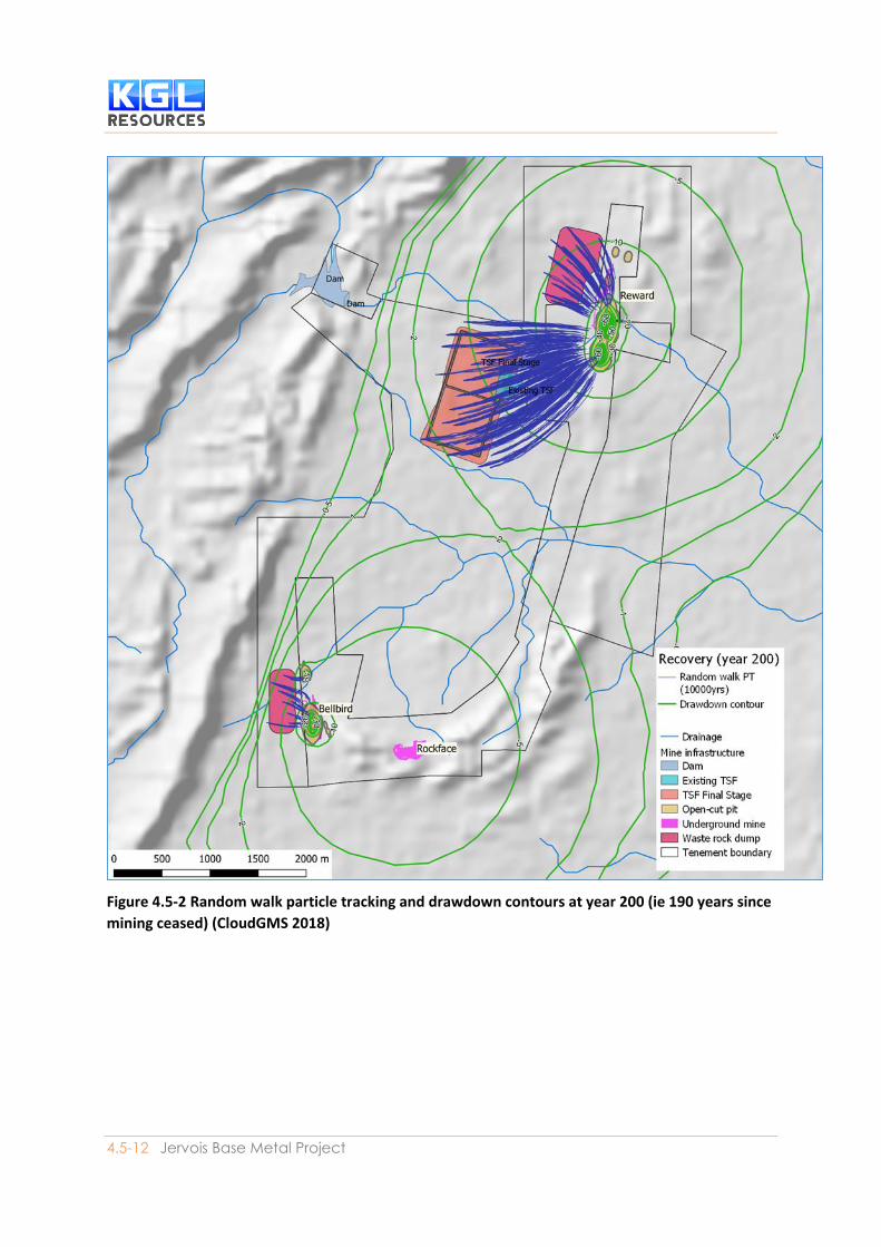
Modelling predicts that 200 years after the commencement of mining (190 years post closure), the
extent of the 0.5 metre drawdown is less than 3 km and no discernible impacts are observed at the
closest pastoral bore (RN018078) or at the Orrtipa-Thurra community water supply (18 km).
Leachate seepage from waste rock dumps
Waste rock dump (WRD) leachate quality is identified as being predominantly non-acid forming (NAF).
Seepage only occurs under high intensity rainfall events. The fate of leachate downgradient of the
waste rock dumps (WRDs) has been forecast using the flow field calculated by the numerical
groundwater modelling and random walk particle tracking. The fate of particles seeded beneath the
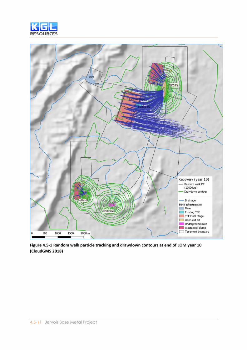
WRDs at the end of LOM are presented in Figure 4.5-1 and at year 200, that is 190 years after the mine
closure (Figure 4.5-2)Error! Reference source not found.. The WRDs downgradient seepage is

Impact Assessment
SECTION 4.5| Inland Waters Environmental Quality 4.5-10
expected to be slow due to the low permeability of the Fractured Rock groundwater system and
ultimately any WRD seepage is expected to be captured by the local groundwater sinks formed at the
Bellbird and Reward pit-lake.
There are no receptors within this distance, and the beneficial use of the water will be unchanged.
Leachate Seepage from Tailings Storage Facility
The mine operation tailings will be stored in a tailings storage facility (TSF) to the west of Reward pit.
TSF leachate quality is identified as being potentially acid forming (PAF). Underdrainage will be
implemented to intercept seepage from TSF. Without proper control some tailing liquor may seep
from storage in the TSF to the groundwater table. This may result in some increase in groundwater
level and change to the chemical composition of groundwater.
The fate of leachate downgradient of the TSF has been forecast using the flow field calculated by the
numerical groundwater modelling and random walk particle tracking (Appendix C6). The fate of
particles seeded beneath the TSF at the end of LOM are presented in Figure 4.5-1 and at year 200,
that is 190 years after the mine closure (Figure 4.5-2)Error! Reference source not found..The TSF
downgradient seepage is expected to be slow due to the low permeability of the Fractured Rock
groundwater system and ultimately any TSF leachate is expected to be captured by the local
groundwater sink form at the Reward pit-lake.
There are no receptors within this distance, and the beneficial use of the water will be unchanged.
Thus, although seepage from the tailings storage facility (TSF) to the water table is expected, it is
considered to present a low risk to groundwater at this project due to the benign nature of the tailings
the Reward pit-lake will effectively capture seepage sourced from TSF preventing the migration of TSF
seepage off-tenement.
Groundwater contamination from spills at the mine site
Groundwater contamination might occur through spills of hazardous material at the mine site or
during transport. The risk will be managed through appropriate storage and transport of hazardous
materials.
Accidental spills or will be managed in accordance with the Emergency Response Management Plan
(ERMP) including the Environmental Investigation Procedure.
4.5-11 Jervois Base Metal Project
Figure 4.5-1 Random walk particle tracking and drawdown contours at end of LOM year 10
(CloudGMS 2018)
4.5-12 Jervois Base Metal Project
Figure 4.5-2 Random walk particle tracking and drawdown contours at year 200 (ie 190 years since
mining ceased) (CloudGMS 2018)

4.5-13 Jervois Base Metal Project
4.5.5 Mitigation and Monitoring During the development of the Project, risks have been considered and where possible removed or
reduced as part of the design process. Risks relevant to water resources and water dependent
environments and users have been considered. The elimination of risk is achieved by removing a
source, pathway or receptor. If this proves impractical then a risk is managed by the implementation
of project controls, which are outlined in the Environmental Management Plan (Section 5).
All works undertaken at the site, including construction, operation and decommissioning, will be
subject to the an overarching Environmental Management Plan (Section 5), which includes
mechanisms for monitoring, auditing and non-conformance correction as part of the quality control
and continual improvement process.
In order to maintain the environmental values of receiving waters around the mine, a series of sub-
plans have also been prepared; Water Management Plan, Groundwater Management Plan, Erosion
and Sediment Control Plan, Waste Management Plan, and Mine Rehabilitation and Closure Plan (refer
Section 5). Through the implementation of the environmental plans, it is not anticipated that there
will be any adverse impacts from water contamination to the downstream environment.
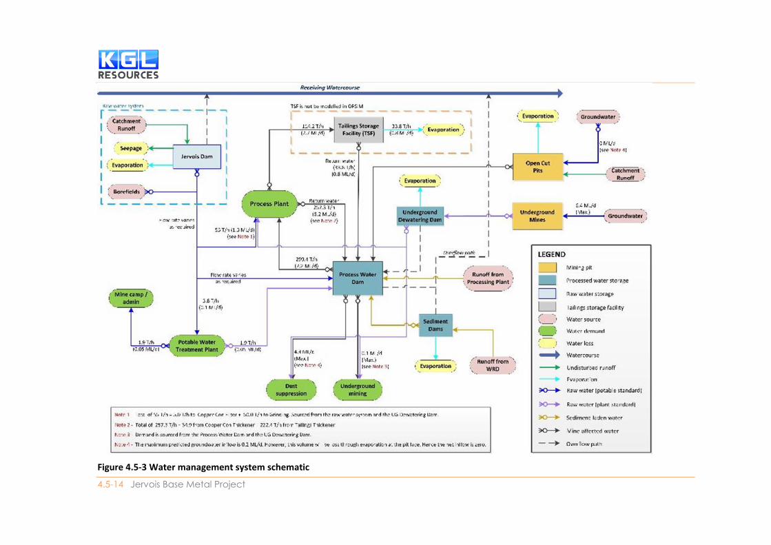
4.5.5.1 Approach to Mine Water Management A Water Management Plan has been prepared for the Project (Section 5). Mine water will be managed
based on quality using the mine water quality classification system (refer Section 4.4 and Section 5).
The classification of mine water in each storage is affected by the water source (e.g., catchment, land
use interactions, etc.), water use and interactions with other waters on site. Water from different
sources will be managed separately (Figure 4.5-1).
The quality of water stored in each mine water storage will be sampled regularly as part of the mine’s
proposed water quality monitoring program to identify trends in water quality over time, inform mine
water management decisions and comply with the water discharge license.
4.5-14 Jervois Base Metal Project
Figure 4.5-3 Water management system schematic

4.5-15 Jervois Base Metal Project
The Project design has incorporated a number of control measures to minimise the potential for the
release of contaminants to the environment. These include:
• Diversion of clean water around the site
• Collection of potentially contaminated water (e.g. mine affected water, and groundwater
seepage)
• Process water dam (180 ML) which will receive: mine affected runoff, pumped transfers from
waste rock dump sediment dam, pump transfers from open cut pits and overflows of raw
water from the underground mine dewatering dam
• storage of diesel at the mine site in self-bunded tanks
• Selection of waste rock material and dump methodology so that runoff will generally be
similar to background runoff
• Repair and enlargement of Jervois Dam
• Tailings Storage Facility (TSF) with sufficient capacity to contain all runoff from tailings storage
area. No runoff, process water or tailings will be released from the TSF.
• Sediment dams to collect runoff and allow suspended solids and associated metalloids to drop
out of suspension; and
• Flood protection bunds along the right bank of Unca Creek and the Unca Creek Diversion to
protect the final void and the TSF from flooding up to the PMF.
Authorised Discharge, Water quality objectives and trigger values
The water quality objectives (WQOs) adopted for the Project have been described earlier and it is anticipated that these WQOs will be applied to any water discharge licence issued for the Project site.
The water balance model suggests that managed releases will not be required from the Project,
however a water discharge license will still be required to ensure flexibility for water management at
the Project. Managed releases from an authorised discharge point are permitted only when the
managed release will not contribute to the exceedance of water quality trigger levels specified in the
water discharge license.
4.5.5.2 Erosion and Sediment Control Erosion and sediment control has been discussed in Section 4.2. An Erosion and Sediment Control
Plan (ESCP) has been prepared to assist in the management, reduction and mitigation of erosion and
consequent sediment transport within and from the Jervois mine (refer Section 5.1F). The primary
goal of the ESCP is to prevent unacceptable levels of sediments and contaminants from leaving the
lease and entering the receiving waters. The ESCP adopts three core strategies to achieve this:
• Drainage control – prevention or reduction of soil erosion caused by concentrated flows and
appropriate management and separation of the movement of clean and dirty water through
the area of concern.

Impact Assessment
SECTION 4.5| Inland Waters Environmental Quality 4.5-16
• Erosion control – prevention or minimisation of soil erosion (from dispersive, non-dispersive
or competent material) caused by rain drop impact and exacerbated overland flow on
disturbed surfaces;and
• Sediment control – trapping or retention of sediment either moving along the land surface,
contained within runoff (i.e. from up-slope erosion) or from windborne particles.
Strategies to minimise increased risk of erosion during the operation phase of the mine site include:
• Minimise the extent of the disturbance
• Prompt revegetation of non-operational disturbed area
• Ensure both temporary earthworks and permanent land-shaping provide a landform that
minimises erosion; and
• Design temporary runoff collection, conveyance and disposal systems to minimise erosion
prior to commencement.
Erosion and sediment control structures will be regularly inspected and monitored for performance.
Water quality (turbidity) in sediment dams at the Jervois mine will be monitored following a significant
runoff event occurring. Controlled releases will only be made if testing indicates that water is of
suitable quality to meet water quality objectives and water discharge license conditions.
4.5.5.3 Management of hazardous substances Storage and handling of hazardous substances will be carried out as specified in their relevant MSDS,
including regular inspection and maintenance of storage facilities. Storage, transport and use of
explosives on site will be conducted in accordance with AS 2187 Explosives Code – Northern Territory.
Procedures for transport and storage of hazardous substances will be implemented as part of the
Health and Safety Management System and will be in accordance with the requirements of the
Transport of Dangerous Goods by Road and Rail (National Uniform Legislation) Act 2016 and Transport
of Dangerous Goods by Road and Rail (National Uniform Legislation) Regulations 2016. Hydrocarbons,
flammable and combustible material will be stored according to the requirements of AS1940-2004
The storage and handling of flammable and combustible liquids.
4.5.5.4 Groundwater Monitoring Groundwater monitoring will comprise:
• Monitoring of drawdown in proximity to the process water supply borefield
• Monitoring of drawdown between the process water supply borefield and third‐party bores
• Monitoring of drawdown in proximity to the mine excavations (pits and underground
workings)
• Monitoring of drawdown between the mine excavations (pits and underground workings) and
third party bores
• Monitoring of dewatering volumes from the pits and underground excavations
• Monitoring at third‐party bores; and
• Monitoring adjacent to the TSF to assess mounding and groundwater quality changes due to
any seepage.

Environmental Impact Statement
4.5-17 Jervois Base Metal Project
Proposed monitoring locations around the Project mine site are presented in Figure 4.5-4.
Water levels at all bores will be measured monthly typically by data logger, downloaded at least
annually.
Water quality will be monitored annually at all observation bores, and quarterly at pumping bores,
WRD and TSF seepage monitoring bores. A full suite of analytes per Table 4.5- will be analysed at all
bores. The monitoring suite and frequency will be reviewed and optimised following two years data
collection.
The volume of water pumped from each bore, and the borefield total will be recorded at least monthly,
using totalizer flow meters at each bore head.
Table 4.5-3 Groundwater monitoring analytical suite
pH Value Aluminium Manganese
Electrical Conductivity Antimony Molybdenum
Total Dissolved Solids Arsenic Selenium
Total Alkalinity as CaCO3 Beryllium Silver
Sulfate as SO4 - Barium Vanadium
Chloride Cadmium Tin
Calcium Chromium Uranium
Magnesium Cobalt Boron
Sodium Copper Iron
Potassium Nickel
Silicate Lead
Fluoride Zinc
Nitrate as N Mercury
4.5.5.5 Groundwater trigger levels and mitigation measures Watertable drawdown from borefield pumping and mine dewatering
Monitoring of bores will be undertaken as described above.
The groundwater model will be run annually to estimate drawdown at each of these observation bores
using the groundwater pumping data recorded at the process water supply borefield and mine
dewatering.
Trigger: measured drawdown at observation bores exceeds the range of drawdown predicted by
modelling.
Impact Assessment
SECTION 4.5| Inland Waters Environmental Quality 4.5-18
Mitigation measures:
• Development of a Class 2 Groundwater flow model will be undertaken in accordance with the
Australian Groundwater Modelling Guidelines (Barnett et al., 2012)
• Make-good measures at other users to ensure water availability. For example, deepening
bores and upgrading pumps
• Increased process water efficiency to be studied and implemented if practicable; and
• Modified pumping regimes to be implemented if significant impacts associated with
groundwater drawdown are identified.
Waste rock dump leachate seepage
Waste rock is anticipated to be deposited to WRDs dry, however, seepage may result during significant
rainfall events. It is unlikely that these events will result in groundwater level rises, although
deterioration of water quality may occur. Groundwater quality downgradient of waste rock dumps
will be monitored at 4 observation bores to detect for the impacts of seepage if it occurs.
Trigger Levels:
• Water level rise beyond seasonal variation; and
• Water quality deteriorating from baseline.
Mitigation measures:
• Assess the impact of water table rise; and
• If seepage from the WRDs causes unacceptable impacts (change in beneficial use) then design
and implement seepage management measures.
TSF leachate seepage
Groundwater levels and water quality downgradient of tailing storage will be monitored at 6
observation bores to detect for the impacts of seepage if it occurs.
Trigger Levels:
• Water level rise beyond seasonal variation; and
• Water quality deteriorating from baseline.
Mitigation measures:
• Assess the impact of water table rise.
If tailing seepage causes unacceptable impacts (water table rise to near surface or change in beneficial
use) then design and implement seepage management measures.
4.5.5.6 Post-mining monitoring and maintenance During mine closure, an extensive closure monitoring program will be incorporated into the updated
mine closure rehabilitation plan (refer Section 5) to investigate the success of rehabilitation and
whether completion criteria are being achieved and to identify any additional work required to meet
success criteria. Rehabilitation will be monitored during operations and after final rehabilitation has
been completed.

Environmental Impact Statement
4.5-19 Jervois Base Metal Project
Monitoring will include:
• Plant establishment, growth, diversity and cover
• Evidence and type of erosion
• Water quality including groundwater and surface water
• Air quality
• Landform stability including cover system performance
• Soil quality; and
• Fauna.
It is expected that maintenance will be required on localised eroded areas and drainage lines for the
first couple of years after closure until vegetation is established, including repair to surface water
management structures, repair of any erosion areas or reseeding of areas due to poor vegetation
establishment.

4.5-20 Jervois Base Metal Project
Figure 4.5-4 Locations of planned observation bores around the Jervois mine site
4.5.5.7 Waste Management A Waste Management Plan has been prepared to provide a framework to manage potential
environmental risk associated with non-mineral waste. Key strategies include:
• Inert waste and municipal solid waste – a landfill be constructed at the Project site for the
disposal this waste. Wastes that would go to the landfill would include: inert waste (concrete,
clay and other unwanted inert waste), general waste (including food scraps), non-recyclable
plastics, non-recyclable glass and glass bottles, used air filters, PPE, other benign solid waste

Environmental Impact Statement
4.5-21 Jervois Base Metal Project
• Sewage and greywater - Sewage and grey water will be treated by licensed onsite sewage
treatment facilities including a plant and septic tank systems as required
• Recyclable waste - Where practicable, recyclable waste including class 1, 2, 5 plastics,
aluminium and steel cans, scrap steel, cardboard, paper, recyclable glass bottles and other
recyclable waste will be collected in designated areas or bins, collected and transported to
off-site recycling collection facilities by licensed contractors
• Green waste - Cleared vegetation will be stockpiled and used for rehabilitation where possible
or stockpiled and burnt on site in designated areas; and
• Listed waste – solid listed wastes will be collected in designated containers, collected and
transported off-site for treatment and/or disposal by licensed contractors. Acidic solutions or
acid in solid forms, perchlorates and other chemical waste from the laboratory will be
collected and transferred to designated containers, neutralised with a suitable alkali (lime)
and discharged into the tailings dam feed stream. Reagents used for processing in the
processing plant, including process water will be recycled and reused where possible. Excess
process water will be discharged into the tailings dam.
4.5.5.8 Emergency Preparedness and Response Potential environmental emergency situations are to be managed through the Jervois Mine
Emergency Response Plan. This plan will be developed by KGL to ensure that the potential
environmental emergency situations arising from a variety of causes, directly or indirectly related to
the Jervois Mine are addressed.
This plan will provide clear guidance on the:
• Emergency Procedures to be undertaken upon the unlikely event of an environmental
emergency situation occurring; and
• Emergency contact register including the contact names and phone numbers of key Project
personnel, other relevant authorities, and off-site emergency services.
The Environmental Management Plan and the various sub-plans also reference the Emergency
Response Plan to create an integrated system.