Embed Size (px)
Citation preview

IDS data structure and formats First version: 2004-02-19 Current version: 2018-10-02 Change history: see the last page
Content IDS data structure and formats ........................................................................................................... 1
0. What kind of information may be found on which center? ................................................................ 2
1. File naming conventions ...................................................................................................................... 3
1.1 Data ............................................................................................................................................... 3
1.1.1 Preprocessed data .................................................................................................................. 3
1.1.2 Raw data (RINEX/DORIS files) ................................................................................................. 4
1.1.3 Quaternions data files ............................................................................................................ 4
1.1.4 Information on data ............................................................................................................... 4
1.2 Products ......................................................................................................................................... 5
1.2.1 Orbits ...................................................................................................................................... 5
1.2.2 Global Sinex solutions (cf IERS naming convention) .............................................................. 6
1.2.3 DPOD solutions ....................................................................................................................... 6
1.2.4 Time series of sinex solutions (monthly, weekly, daily, ...) .................................................... 7
1.2.5 Time series of specific geodetic products .............................................................................. 7
1.2.6 Ionosphere products .............................................................................................................. 8
1.3 Documentation .............................................................................................................................. 8
2. Data centers structure ......................................................................................................................... 9
2.1 Information .................................................................................................................................... 9
2.2 Data ............................................................................................................................................. 18
2.3 Products ....................................................................................................................................... 20
3. Formats .............................................................................................................................................. 24
3.1 Data ............................................................................................................................................. 24
3.2 Products ....................................................................................................................................... 24
3.2.1 Orbits .................................................................................................................................... 24
3.2.2 Global Sinex solutions, DPOD solutions, Time series of Sinex solutions .............................. 24
3.2.3 Time series of specific products ........................................................................................... 24
3.2.4 Products documentation files .............................................................................................. 24
Change history ....................................................................................................................................... 25
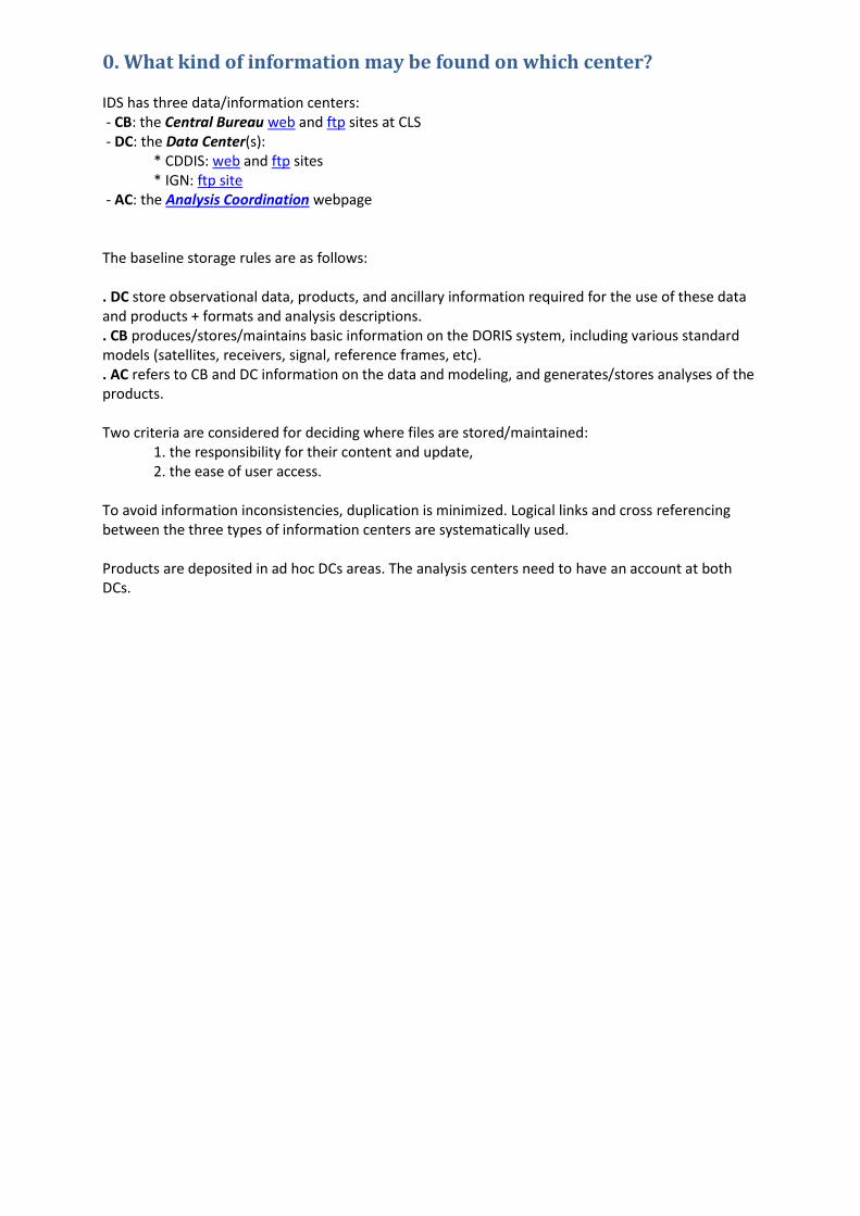
0. What kind of information may be found on which center? IDS has three data/information centers: - CB: the Central Bureau web and ftp sites at CLS - DC: the Data Center(s):
* CDDIS: web and ftp sites * IGN: ftp site
- AC: the Analysis Coordination webpage The baseline storage rules are as follows: . DC store observational data, products, and ancillary information required for the use of these data and products + formats and analysis descriptions. . CB produces/stores/maintains basic information on the DORIS system, including various standard models (satellites, receivers, signal, reference frames, etc). . AC refers to CB and DC information on the data and modeling, and generates/stores analyses of the products. Two criteria are considered for deciding where files are stored/maintained:
1. the responsibility for their content and update, 2. the ease of user access.
To avoid information inconsistencies, duplication is minimized. Logical links and cross referencing between the three types of information centers are systematically used. Products are deposited in ad hoc DCs areas. The analysis centers need to have an account at both DCs.

1. File naming conventions Filenames include only numbers and lower cap characters, including station names, with the exception of the ".Z" extension indicating compressed files. Data and product files are compressed using UNIX compression format.
1.1 Data
1.1.1 Preprocessed data sssdataMMM.LLL.Z where:
sss the satellite three-character abbreviation (1) data fixed part MMM the three-digit cycle/arc number (2) LLL version number (starting with 001 for the initial version) when the file is replaced Z (upper case) indicates compressed file (Unix)
Ex: sp2data033.001.Z Note 1: Three-character satellite name abbreviations:
Spot-2: sp2 Spot -3: sp3 Spot -4: sp4 Spot -5: sp5 Topex/Poseidon: top Jason-1: ja1 Jason-2: ja2 Jason-3: ja3 Envisat: en1 Cryosat-2: cs2 HY2A: h2a Saral: srl Sentinel-3a: s3a Sentinel-3b: s3b All satellites: zzz
Note 2: "cycles" refer to Topex/Poseidon and Jason satellites (about 10 days) "arcs" refer to the Spot satellites Envisat: 7-day arcs (the cycle length is exactly 35 days) Note 3: Spot2: the first 10 data files (31.03.90-02.11.92) are organized in monthly files. The file names range from sp2data9003.dat.Z through sp2data9211.dat.Z Note 4: Envisat: the first data file (en1data001.001.Z) corresponds to the first arc of repeat cycle 7. The Envisat repeat cycle number for a given DORIS Data Center arc number can be found using the formula cycle=int(0.2*(arc+34)).
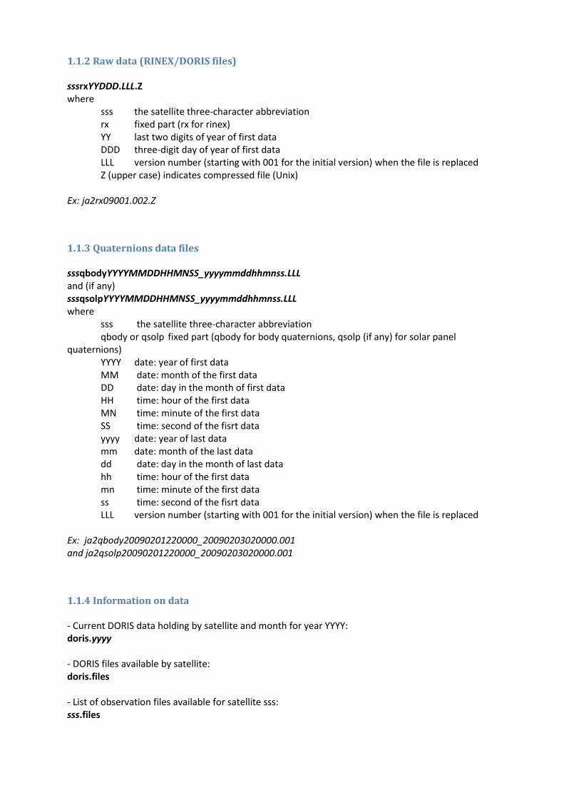
1.1.2 Raw data (RINEX/DORIS files) sssrxYYDDD.LLL.Z where
sss the satellite three-character abbreviation rx fixed part (rx for rinex) YY last two digits of year of first data DDD three-digit day of year of first data LLL version number (starting with 001 for the initial version) when the file is replaced Z (upper case) indicates compressed file (Unix)
Ex: ja2rx09001.002.Z
1.1.3 Quaternions data files sssqbodyYYYYMMDDHHMNSS_yyyymmddhhmnss.LLL and (if any) sssqsolpYYYYMMDDHHMNSS_yyyymmddhhmnss.LLL where
sss the satellite three-character abbreviation qbody or qsolp fixed part (qbody for body quaternions, qsolp (if any) for solar panel
quaternions) YYYY date: year of first data MM date: month of the first data DD date: day in the month of first data HH time: hour of the first data MN time: minute of the first data SS time: second of the fisrt data yyyy date: year of last data mm date: month of the last data dd date: day in the month of last data hh time: hour of the first data mn time: minute of the first data ss time: second of the fisrt data LLL version number (starting with 001 for the initial version) when the file is replaced
Ex: ja2qbody20090201220000_20090203020000.001 and ja2qsolp20090201220000_20090203020000.001
1.1.4 Information on data - Current DORIS data holding by satellite and month for year YYYY: doris.yyyy - DORIS files available by satellite: doris.files - List of observation files available for satellite sss: sss.files
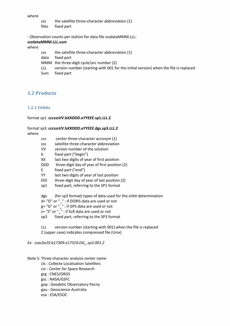
where sss the satellite three-character abbreviation (1) files fixed part
- Observation counts per station for data file sssdataMMM.LLL: sssdataMMM.LLL.sum where
sss the satellite three-character abbreviation (1) data fixed part MMM the three-digit cycle/arc number (2) LLL version number (starting with 001 for the initial version) when the file is replaced Sum fixed part
1.2 Products
1.2.1 Orbits format sp1: cccsssVV.bXXDDD.eYYEEE.sp1.LLL.Z format sp3: cccsssVV.bXXDDD.eYYEEE.dgs.sp3.LLL.Z where
ccc center three-character acronym (1) sss satellite three-character abbreviation VV version number of the solution b fixed part ("begin") XX last two digits of year of first position DDD three-digit day of year of first position (2) E fixed part ("end") YY last two digits of year of last position EEE three-digit day of year of last position (2) sp1 fixed part, referring to the SP1 format dgs (for sp3 format) types of data used for the orbit determination d= "D" or "_" : if DORIS data are used or not g= "G" or "_" : if GPS data are used or not s= "S" or "_" : if SLR data are used or not sp3 fixed part, referring to the SP3 format
LLL version number (starting with 001) when the file is replaced Z (upper case) indicates compressed file (Unix)
Ex: ssas3a10.b17309.e17319.DG_.sp3.001.Z Note 5: Three-character analysis center name
cls : Collecte Localisation Satellites csr : Center for Space Research grg : CNES/GRGS gsc : NASA/GSFC gop : Geodetic Observatory Pecny gau : Geoscience Australia esa : ESA/ESOC
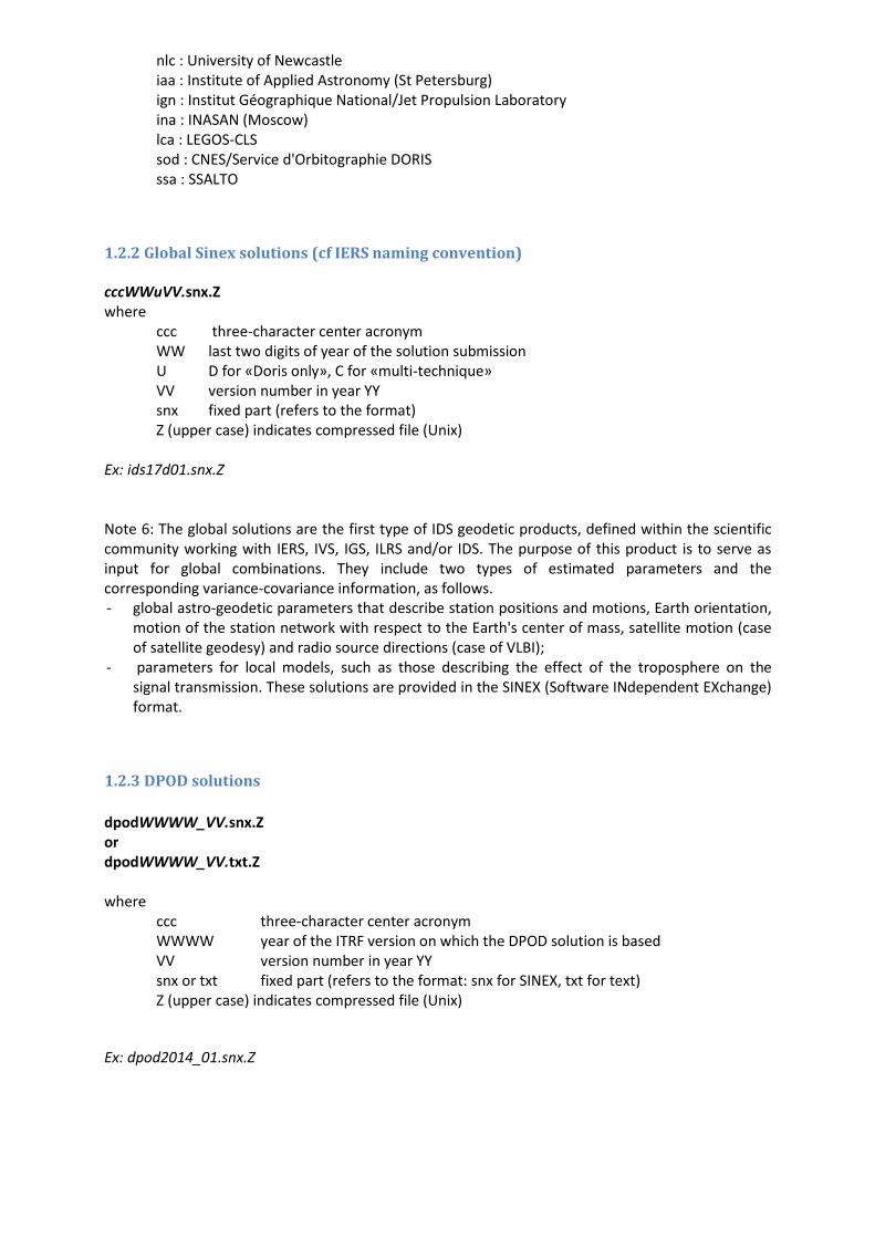
nlc : University of Newcastle iaa : Institute of Applied Astronomy (St Petersburg) ign : Institut Géographique National/Jet Propulsion Laboratory ina : INASAN (Moscow) lca : LEGOS-CLS sod : CNES/Service d'Orbitographie DORIS ssa : SSALTO
1.2.2 Global Sinex solutions (cf IERS naming convention) cccWWuVV.snx.Z where
ccc three-character center acronym WW last two digits of year of the solution submission U D for «Doris only», C for «multi-technique» VV version number in year YY snx fixed part (refers to the format) Z (upper case) indicates compressed file (Unix)
Ex: ids17d01.snx.Z Note 6: The global solutions are the first type of IDS geodetic products, defined within the scientific community working with IERS, IVS, IGS, ILRS and/or IDS. The purpose of this product is to serve as input for global combinations. They include two types of estimated parameters and the corresponding variance-covariance information, as follows. - global astro-geodetic parameters that describe station positions and motions, Earth orientation,
motion of the station network with respect to the Earth's center of mass, satellite motion (case of satellite geodesy) and radio source directions (case of VLBI);
- parameters for local models, such as those describing the effect of the troposphere on the signal transmission. These solutions are provided in the SINEX (Software INdependent EXchange) format.
1.2.3 DPOD solutions
dpodWWWW_VV.snx.Z or dpodWWWW_VV.txt.Z where
ccc three-character center acronym WWWW year of the ITRF version on which the DPOD solution is based VV version number in year YY snx or txt fixed part (refers to the format: snx for SINEX, txt for text) Z (upper case) indicates compressed file (Unix)
Ex: dpod2014_01.snx.Z
1.2.4 Time series of sinex solutions (monthly, weekly, daily, ...) cccYYDDDtuVV.snx.Z where
ccc center three-character acronym YY last two digits of year of the first observation DDD three-digit day of year of the first observation. T type of the solution: m/w/d for monthly/weekly/daily solutions u d for «Doris only», c for «multitechnique» VV version number of the solution snx fixed part (refers to the format) Z (upper case) indicates compressed file (Unix)
Ex: ids00002wd04.snx.Z Note 7: These solutions are defined similarly to the solutions above, except for the time span of the data used: they may be based on monthly, weekly, daily, etc observation sets. The purpose of this product is to serve as input for multi-technique combinations of time series. They are provided in the SINEX format. Note 8: There is no mention of the satellite name in the filename. This information may be found in the headers of each file. Note 9: Each sinex file in the series may have a summary file cccYYDDDtuVV.sum giving statistics of this data set, e.g. global, per satellite, per station, and any information useful for the user of the product file.
1.2.5 Time series of specific geodetic products cccWWtuVV.stcd.aaaa.Z for station coordinates cccWWtuVV.stcd.aaaa.gif for plots of station coordinates cccWWtuVV.geoc.Z for coordinates of the TRF origin (geocenter) cccWWtuVV.eop.Z for Earth orientation parameters (EOP) where
ccc the center three-character acronym WW year of submission T type of the solution: m/w/d for monthly/weekly/daily solutions U d for «Doris only», c for «multi-technique» VV version number in year YY Z (upper case) indicates compressed file (Unix)
stcd fixed part (refers to the content) aaaa station name (four characters) geoc fixed part (refers to the content) eop fixed part (refers to the content)
Ex: ids17wd05.stcd.adea.Z ids17wd05.stcd.adea.gif ina16wd01.geoc.Z ina16wd01.eop.Z
Note 10: In principle, these times series are extracted by the Central Bureau from the time series of SINEX solutions (see 1.2.3). In this case, the documentation file is ccctuVV.snx.dsc (see hereafter). If the Analysis center provides stcd/geoc/eop time series, they must provide the corresponding .dsc documentation file(s).
1.2.6 Ionosphere products
cccsssVV.YYDDD.iono.Z where
ccc center three-character acronym sss satellite three-character abbreviation VV version number of the solution YY last two digits of year DDD three-digit day of year Iono fixed part (refers to the content) Z (upper case) indicates compressed file (Unix)
Ex: ssasp501.02124.iono.Z
1.3 Documentation Each data/product file, or series of data/product files, mentioned hereafter shall be accompanied by a file describing the analysis and modeling used to derive it. The .dsc files for products would be similar to the explanation files for the submission of contributions to ITRF. The filenames are constructed as follows.
Data/Product item Data/Product file Description file
Data sssdataMMM.LLL.Z sssdataMMM.dsc
Raw data sssrxYYDDD.LLL.Z sssrxYYDDD.desc
Data summary sssdataMMM.LLL.sum sssdata.LLL.sum.dsc
Quaternions and solar panel angles
sssqbodyYYYYMMDDHHMMSS_yyyymmddhhmnss.LLL sssqsolpYYYYMMDDHHMMSS_yyyymmddhhmnss.LLL
Orbits cccsssVV.bXXDDD.eYYEEE.sp1.Z cccsssVV.sp1.dsc
cccsssVV.bXXDDD.eYYEEE.dgs.sp3.Z cccsssVV.sp3.dsc
Global sinex solutions cccWWuVV.snx.Z cccWWuVV.snx.dsc
Time series of sinex solutions cccYYDDDtuVV.snx.Z ccctuVV.snx.dsc
cccYYDDDtuVV.sum
Station coordinates differences time series cccWWtuVV.stcd.aaaa.Z cccWWtuVV.stcd.dsc
TRF origin time series cccWWtuVV.geoc.Z cccWWtuVV.geoc.dsc
EOP time series cccWWtuVV.eop.Z cccWWtuVV.eop.dsc
Iono files cccsssVV.YYDDD.iono.Z cccsssVV.iono.dsc
2. Data centers structure
2.1 Information Information is stored and maintained at the CB ftp site
The main directories are:
ancillary/ documents about the DORIS ancillary data centers/ documents for the analysis centers combination_center/ products and reports of the combination center combinations/ working directory of the combination center data/ documents about the DORIS data dorismail/ archive of the mails of DORISmail mailing list dorisreport/ archive of the mails of DORISreport mailing list dorisstations/ archive of the mails of DORISstations mailing list events/ lists of events occurring on the DORIS system ids.analysis.forum/ archive of the mails of ids.analysis.forum mailing list plottool_files/ archive of the database for the plottools products/ format descriptions of the products satellites/ documents and data related to the satellites stations/ documents and data related to the stations
Material:
/pub/ids/ (documents)
DORIS_System_Definition.pdf describing the DORIS missions, then the DORIS system in details, with its external and internal
connections. This document applies to the DORIS system from the DGXX generation.
DOR-O-T_Webservice_2014.pdf presentation leaflet of the IDS Webservice DOR-O-T which provides tools to browse time series in an
interactive and intuitive way
WhatIsDORIS.pdf DORIS for beginners
(directories)
ancillary/ quaternions/
cryosat2_quaternions_TUdelft_description.pdf information about: -quaternions for Cryosat-2 -time frames when the nominal attitude law is off for Cryosat-2
jason1_2_quaternion_solar_panel.pdf descriptions of the quaternion and solar panel files for Jason1&2
centers/ blnkform.acn
blankform
ccc.acn describing the permanent features of center ccc
Template_analysis_summary.xls template of the analysis summary in excel format
Note11 : The .acn information files concern permanent features of center, while the .dsc information files concern a given set of analyses.
combination_center/
products/
reports/
combinations/
data/ (documents)
detailed_POD_configuration.pdf (link to detailed_POD_configuration_200801.pdf) Detailed standards of the CNES/SOD POD configuration for the DORIS satellites
doris10.fmt DORIS Data Exchange Format Version 1.0 (April 1992)
doris21.fmt DORIS Data Exchange Format Version 2.1 (January 2002)
doris22.fmt DORIS Data Exchange Format Version 2.2 (June 2008)
DORIS_models&solutions_v1.0.pdf Model equations for a complete solution using the DORIS raw phase and pseudo-range
measurements
DORIS_RINEX_implementation_in_GINS.v2.0.pdf Doppler observation equation in the GINS software
DORIS_RINEX_subroutines_from_GINS.tar Routines to read DORIS/RINEX files (courtesy by Jean-michel Lemoine, CNES)
IntroductionToDORISRINEX.pdf A quick description of the DORIS/RINEX format
POD_configuration_GDRD.pdf Summarize of the GDR-D configuration applied by CNES/SOD POD (2012)
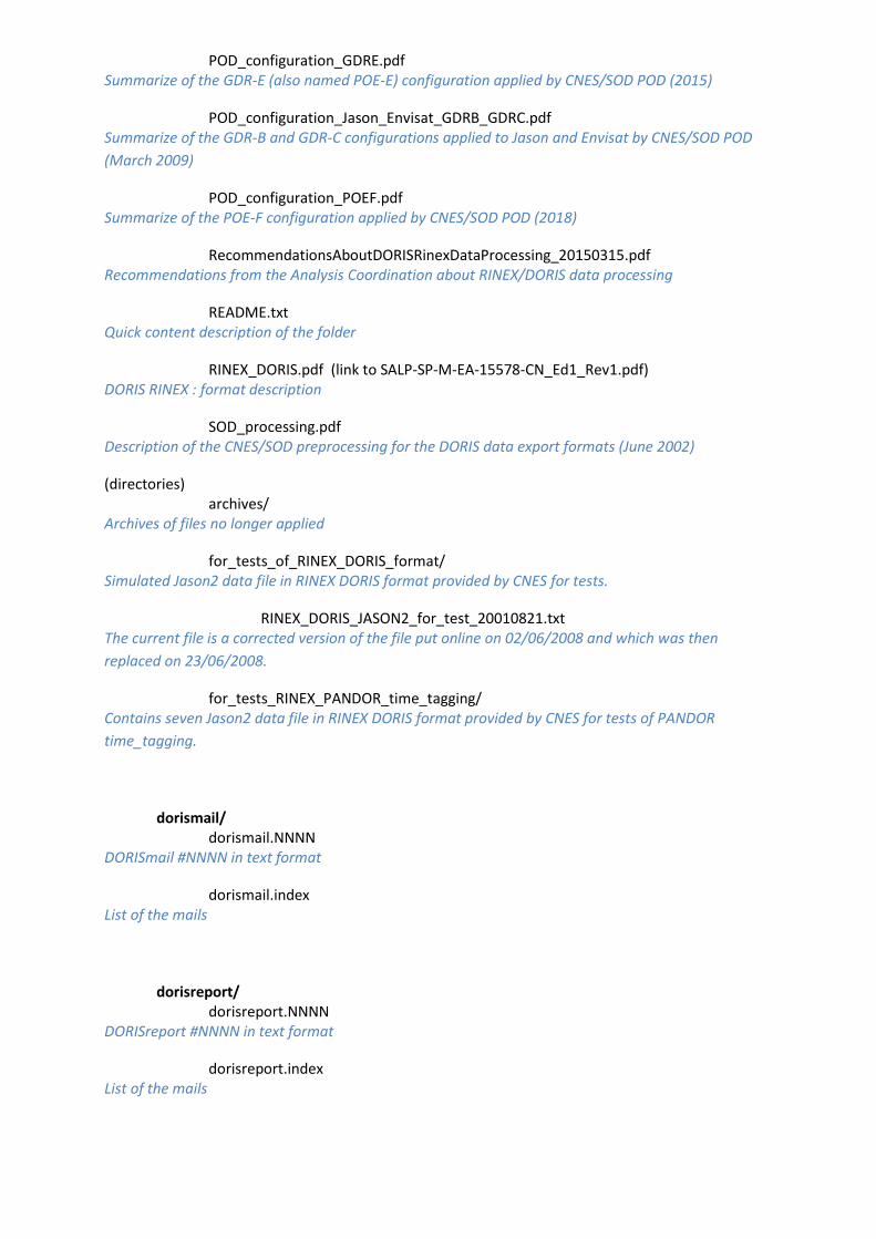
POD_configuration_GDRE.pdf Summarize of the GDR-E (also named POE-E) configuration applied by CNES/SOD POD (2015)
POD_configuration_Jason_Envisat_GDRB_GDRC.pdf Summarize of the GDR-B and GDR-C configurations applied to Jason and Envisat by CNES/SOD POD
(March 2009)
POD_configuration_POEF.pdf Summarize of the POE-F configuration applied by CNES/SOD POD (2018)
RecommendationsAboutDORISRinexDataProcessing_20150315.pdf Recommendations from the Analysis Coordination about RINEX/DORIS data processing
README.txt Quick content description of the folder
RINEX_DORIS.pdf (link to SALP-SP-M-EA-15578-CN_Ed1_Rev1.pdf) DORIS RINEX : format description
SOD_processing.pdf Description of the CNES/SOD preprocessing for the DORIS data export formats (June 2002)
(directories) archives/
Archives of files no longer applied
for_tests_of_RINEX_DORIS_format/ Simulated Jason2 data file in RINEX DORIS format provided by CNES for tests.
RINEX_DORIS_JASON2_for_test_20010821.txt The current file is a corrected version of the file put online on 02/06/2008 and which was then
replaced on 23/06/2008.
for_tests_RINEX_PANDOR_time_tagging/ Contains seven Jason2 data file in RINEX DORIS format provided by CNES for tests of PANDOR
time_tagging.
dorismail/ dorismail.NNNN
DORISmail #NNNN in text format
dorismail.index List of the mails
dorisreport/ dorisreport.NNNN
DORISreport #NNNN in text format
dorisreport.index List of the mails
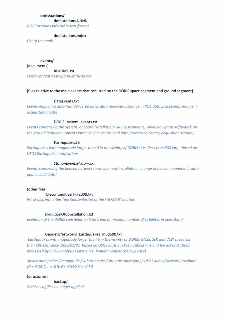
dorisstations/ dorisstations.NNNN
DORISstations #NNNN in text format
dorisstations.index List of the mails
events/ (documents)
README.txt Quick content description of the folder
[files relative to the main events that occurred on the DORIS space segment and ground segment]
DataEvents.txt Events impacting data (not delivered data, data redelivery, change in POE data processing, change in
acquisition mode)
DORIS_system_events.txt Events concerning the System: onboard (satellites, DORIS instruments, Diode navigator software), on
the ground (Satellite Control Center, DORIS control and data processing center, acquisition station)
Earthquakes.txt Earthquakes with magnitude larger than 6 in the vicinity of DORIS sites (less than 500 km) - based on
USGS Earthquake notifications
StationEventsHistory.txt Events concerning the beacon network (new site, new installation, change of beacon equipment, data
gap, invalid data)
[other files] DiscontinuitiesITRF2008.txt list of discontinuities (position/velocity) of the ITRF2008 solution
EvolutionOfConstellation.txt evolution of the DORIS constellation (start, end of mission; number of satellites in operation)
GeodeticNetworks_Earthquakes_m6d500.txt Earthquakes with magnitude larger than 6 in the vicinity of DORIS, GNSS, SLR and VLBI sites (less
than 500 km) since 1993/01/01 based on USGS Earthquakes notifications and the list of stations
processed by GRGS Analysis Centers (i.e. limited number of GNSS sites).
fields: date / time / magnitude / 4-letter code / site / distance (km) / USGS index (N=New) / technics
(D = DORIS; L = SLR; G= GNSS; V = VLBI)
(directories) backup/
Archives of files no longer applied
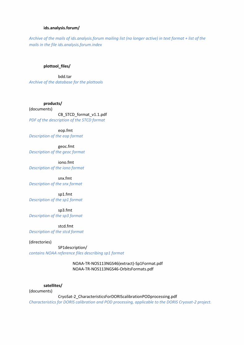
ids.analysis.forum/
Archive of the mails of ids.analysis.forum mailing list (no longer active) in text format + list of the
mails in the file ids.analysis.forum.index
plottool_files/
bdd.tar Archive of the database for the plottools
products/ (documents)
CB_STCD_format_v1.1.pdf PDF of the description of the STCD format
eop.fmt Description of the eop format
geoc.fmt Description of the geoc format
iono.fmt Description of the iono format
snx.fmt Description of the snx format
sp1.fmt Description of the sp1 format
sp3.fmt Description of the sp3 format
stcd.fmt Description of the stcd format
(directories) SP1description/
contains NOAA reference files describing sp1 format
NOAA-TR-NOS113NGS46(extract)-Sp1Format.pdf NOAA-TR-NOS113NGS46-OrbitsFormats.pdf
satellites/ (documents)
CryoSat-2_CharacteristicsForDORIScalibrationPODprocessing.pdf Characteristics for DORIS calibration and POD processing, applicable to the DORIS Cryosat-2 project.
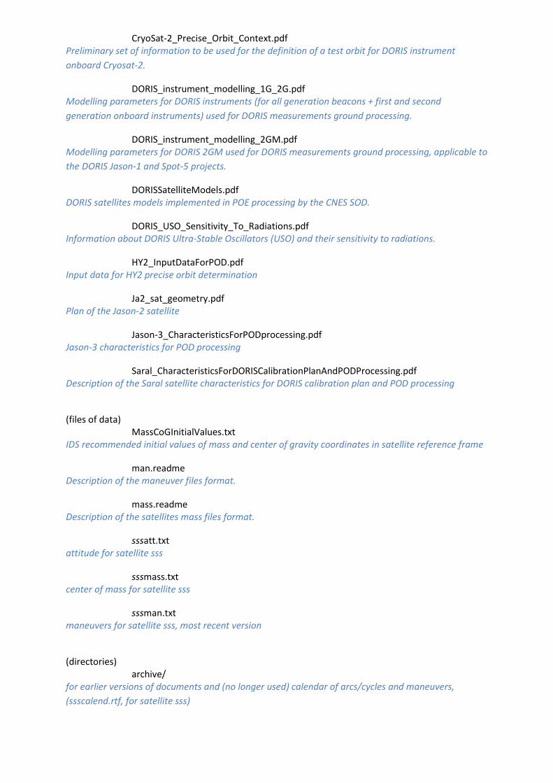
CryoSat-2_Precise_Orbit_Context.pdf Preliminary set of information to be used for the definition of a test orbit for DORIS instrument
onboard Cryosat-2.
DORIS_instrument_modelling_1G_2G.pdf Modelling parameters for DORIS instruments (for all generation beacons + first and second
generation onboard instruments) used for DORIS measurements ground processing.
DORIS_instrument_modelling_2GM.pdf Modelling parameters for DORIS 2GM used for DORIS measurements ground processing, applicable to
the DORIS Jason-1 and Spot-5 projects.
DORISSatelliteModels.pdf DORIS satellites models implemented in POE processing by the CNES SOD.
DORIS_USO_Sensitivity_To_Radiations.pdf Information about DORIS Ultra-Stable Oscillators (USO) and their sensitivity to radiations.
HY2_InputDataForPOD.pdf Input data for HY2 precise orbit determination
Ja2_sat_geometry.pdf Plan of the Jason-2 satellite
Jason-3_CharacteristicsForPODprocessing.pdf Jason-3 characteristics for POD processing
Saral_CharacteristicsForDORISCalibrationPlanAndPODProcessing.pdf Description of the Saral satellite characteristics for DORIS calibration plan and POD processing
(files of data)
MassCoGInitialValues.txt IDS recommended initial values of mass and center of gravity coordinates in satellite reference frame
man.readme Description of the maneuver files format.
mass.readme Description of the satellites mass files format.
sssatt.txt attitude for satellite sss
sssmass.txt center of mass for satellite sss
sssman.txt maneuvers for satellite sss, most recent version
(directories)
archive/ for earlier versions of documents and (no longer used) calendar of arcs/cycles and maneuvers,
(ssscalend.rtf, for satellite sss)
attitude-archive/ for earlier versions of sssatt.txt (sssatt.yymmdd)
CORRECTIVE_MODEL_JASON1/ This directory provides: - the corrective model of DORIS/Jason USO frequency - the technical note describing the model, how to implement it in a UNIX environment, and how to use
it.
ephemeris/ SP1 files of orbit ephemeris provided by LCA Analysis Center for Envisat, Jason-1, Spot-2, Spot-3, Spot-
4, Spot-5, Topex from the start of the missions until the end of April 2008
maneuver-archive/ for earlier versions of sssman.txt (sssman.yymmdd)
mass-archive/
for earlier versions of sssmass.txt (sssmass.yymmdd)
statpoe/ statpoe_global_yyyy.pdf
RMS of POE residuals of the whole network for each satellite for year yyyy
statpoe_sat_ssssss_yyyy.pdf RMS of POE residuals of each station for one satellite ssssss for year yyyy
VTS-projects/ This directory provides predefined scenarios for the DORIS missions to be used with the software VTS
to animate the satellites in 2D or 3D environments
stations/ (documents)
3rdGenerationFrequencyShifts frequency shifts of the 3rd beacons
AboutStationEquipmentAndFrequency.pdf DORIS station equipment / impact on the frequency
antennas.pdf ground antennas geometrical characteristics
DORIS_beacon_RF_characteristics.pdf Definition of the radio-frequency characteristics of a DORIS beacon
doris_phase_law_antex_readme.txt Description of the phase law antex files
DORIS_Site_Standard_Configurations.pdf Description of the standard configurations compliant with the DORIS system requirements applicable
to the management of the DORIS station network
DORIS_System_Ground_Segment_Models.pdf Modelling parameters for DORIS ground equipments (for all generation beacons) used for DORIS
measurements ground processing
Interface_Specification_Between_Beacons_And_Onboard_Instrument.pdf Definition of the interface specifications between the DORIS network beacons and the onboard
receiver.
Interface_Specification_Between_Beacons_And_Onboard_Instrument_extract.pdf Extract of the document ““Interface Specification Between the DORIS Network beacons and the
onboard instrument”.
System_Requirements_For_Management_Of_The_DORIS_Station_Network.pdf Description of the DORIS system requirements applicable to the management of the DORIS station
network
jason-visibility.jpg Visibility circles for the Jasons satellites
spot4-visibility.jpg Visibility circles for the Spot-4 satellite
(files of data)
DORIS_ext_ties.txt DORIS tie vectors between DORIS and others IERS techniques, current file
DORIS_int_ties.txt DORIS internal ties - vectors between different antennas on the same site, current file
doris_phase_law_antex_alcatel.txt Latest version of the phase law for Alcatel antennas
doris_phase_law_antex_alcatel13.txt Phase law for Alcatel antennas based on the characterization performed in 2013
doris_phase_law_antex_alcatel17.txt Phase law for Alcatel antennas based on the characterization performed in 2017
doris_phase_law_antex_starec.txt Latest version of the phase law for Starec antennas
doris_phase_law_antex_starec13.txt Phase law for Starec antennas based on the characterization performed in 2017
itrf2000_doris.snx ITRF2000 DORIS station positions at epoch 1997.0 and velocities
ITRF2008-TRF.SNX.gz ITRF2008 station positions at epoch 2005.0 and velocities
(directories) DORIS_int_ties_PreviousVersions/
DORIS_int_ties_yyymmdd DORIS internal ties of date yyymmdd
events/
station_frequency_shift.txt Latest version of the list of the stations using the shifted mode and the corresponding K factor
archive/ Archive of the successive versions of the file station_frequency_shift.txt
IDS_recommendations_for_ITRF2004/
files recoms for ITRF2004, period to delete, station breaks..
network/
colocation_GNSS_Nov2010.pdf (A EFFACER ?; elle est sur le site) DORIS and GNSS colocations
colocation_IERS_Nov2013.pdf (A EFFACER ?; on a plus récent sur le site) DORIS stations co-located with other techniques (VLBI, SLR, GNSS)
coloc_Earthquake_Nov2010.pdf (A EFFACER ? elle est sur le site) DORIS Network and Earthquakes since 1900 (USGC Database)
coloc_IERS_Nov2010.pdf (A EFFACER ?; on a plus récent sur le site) DORIS stations co-located with other techniques (VLBI, SLR, GNSS)
coloc_Tide_Gauge_Nov2010.pdf (A EFFACER ?; elle est sur le site) DORIS and tide-gauges colocations
OLD_files/
Archives of files no longer updated
sitelogs/
Collection of DORIS site description forms
SSSS.LOG DORIS site description forms for the station SSSS
archive/ Archive of the previous versions
statpoe/
statpoe_sta_SSSS_yyyy.pdf RMS of POE residuals of one station SSSS for each satellite for year yyyy
Note 12: The cb_mirror/ directory at CDDIS and IGN results from the mirroring by the DC of the CB ftp site
2.2 Data Data are mainly stored and maintained at the Data Centers
* CDDIS: ftp site * IGN: ftp site
Note: some other data files (mass, maneuvers, attitude…) are stored at the CB ftp site (see 2.1)
The main directories are:
ancillary/ DORIS ancillary data (e.g. quaternions) campdata/ DORIS campaign data data/ DORIS data general General information about DORIS data
Material:
/pub/doris/
ancillary/ quaternions/
(document) README_QUATERNIONS.txt
Quick content description of the folder
(directories) sss/
for the satellite sss = ja1, ja2, ja3 sssqbodyYYYYMMDDHHMMSS_yyyymmddhhmnss.LLL
body quaternions data file per 24h
sssqsolpYYYYMMDDHHMMSS_yyyymmddhhmnss.LLL if any, solar panel angle file per 24h
campdata/ saacorrection/
SAA-corrected data
sss/ for the satellite sss = ja1, sp5
sssdataMMM.saa.Z
data/ (file)
doris.files DORIS files by satellite for each year
(directories)
campaign/
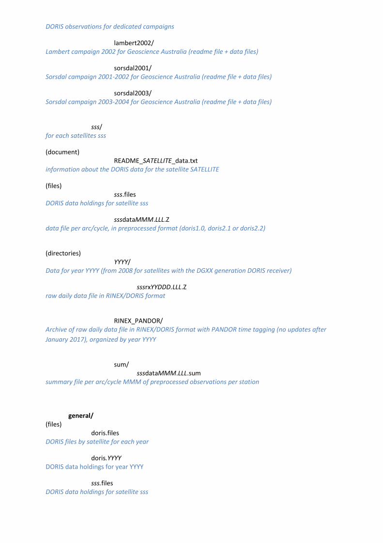
DORIS observations for dedicated campaigns
lambert2002/ Lambert campaign 2002 for Geoscience Australia (readme file + data files)
sorsdal2001/ Sorsdal campaign 2001-2002 for Geoscience Australia (readme file + data files)
sorsdal2003/ Sorsdal campaign 2003-2004 for Geoscience Australia (readme file + data files)
sss/
for each satellites sss
(document) README_SATELLITE_data.txt
information about the DORIS data for the satellite SATELLITE
(files) sss.files
DORIS data holdings for satellite sss
sssdataMMM.LLL.Z data file per arc/cycle, in preprocessed format (doris1.0, doris2.1 or doris2.2)
(directories)
YYYY/ Data for year YYYY (from 2008 for satellites with the DGXX generation DORIS receiver)
sssrxYYDDD.LLL.Z raw daily data file in RINEX/DORIS format
RINEX_PANDOR/
Archive of raw daily data file in RINEX/DORIS format with PANDOR time tagging (no updates after
January 2017), organized by year YYYY
sum/
sssdataMMM.LLL.sum summary file per arc/cycle MMM of preprocessed observations per station
general/
(files) doris.files
DORIS files by satellite for each year
doris.YYYY DORIS data holdings for year YYYY
sss.files DORIS data holdings for satellite sss

2.3 Products Products are stored and maintained at the Data Centers
* CDDIS: ftp site * IGN: ftp site
The main directory is are:
products / IDS product archive 2002campaign/ archive for 2002 IDS analysis campaign 2003campaign/ archive for 2003 IDS analysis campaign 2010campaign/ archive for 2010 IDS analysis campaign dpod/ DPOD solutions (DORIS extension of the ITRF for Precise Orbit Determination) eop/ Earth Orientation Parameters geoc/ geocenter motion iono/ ionospheric corrections orbits/ orbit ephemerides sinex_global/ solutions of station coordinates and velocities sinex_series/ series of station coordinate solutions stcd/ time series of station coordinates differences
Material:
/pub/doris/products/
2002campaign/ (products stored as received)
2003campaign/
(products stored per analysis center)
2010campaign/
(products stored per analysis center)
dpod/ (document)
dpod.readme description of the folder
(product files) dpod2014_current.snx.Z
latest version of the DPOD2014 solution in sinex format
dpod2014_current.txt.Z latest version of the DPOD2014 solution in text format
(directories) dpod2000/
subdirectory containing all the DPOD2000 solutions
dpod2005/ subdirectory containing all the DPOD2005 solutions
dpod2008/ subdirectory containing all the DPOD2008 solutions
dpod2014/ subdirectory containing all the DPOD2014 solutions
eop/
(documents) ccc.eop.readme
ccc description of their series of products
cccWWtuVV.eop.dsc analysis description
(product files) cccWWtuVV.eop.Z
time series
Note: production center ccc provides two files per solution (description and time series)
geoc/
(documents) ccc.geoc.readme
ccc description of their series of products
cccWWtuVV.geoc.dsc analysis description
(product files) cccWWtuVV.geoc.Z
time series
Note: production center ccc provides two files per solution (description and time series)
iono/
(directories) ccc/
directory for the product of analysis center ccc
(document) ccc.iono.readme
ccc description of their series of products
(subdirectories) sss/
subdirectory for the satellite sss
(document) cccsssVV.iono.dsc
analysis description
(product files) cccsssVV.YYDDD.iono.Z
results for day DDD of year YY
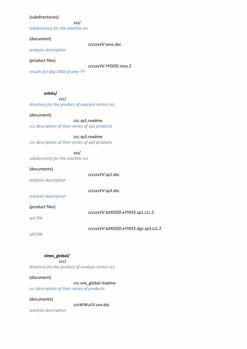
orbits/
ccc/ directory for the product of analysis center ccc
(document) ccc.sp1.readme
ccc description of their series of sp1 products
ccc.sp3.readme ccc description of their series of sp3 products
sss/ subdirectory for the satellite sss
(documents) cccsssVV.sp1.dsc
analysis description
cccsssVV.sp3.dsc analysis description
(product files) cccsssVV.bXXDDD.eYYEEE.sp1.LLL.Z
sp1 file
cccsssVV.bXXDDD.eYYEEE.dgs.sp3.LLL.Z sp3 file
sinex_global/
ccc/ directory for the product of analysis center ccc
(document) ccc.snx_global.readme
ccc description of their series of products
(documents) cccWWuVV.snx.dsc
analysis description
(product files) cccWWuVV.snx.Z
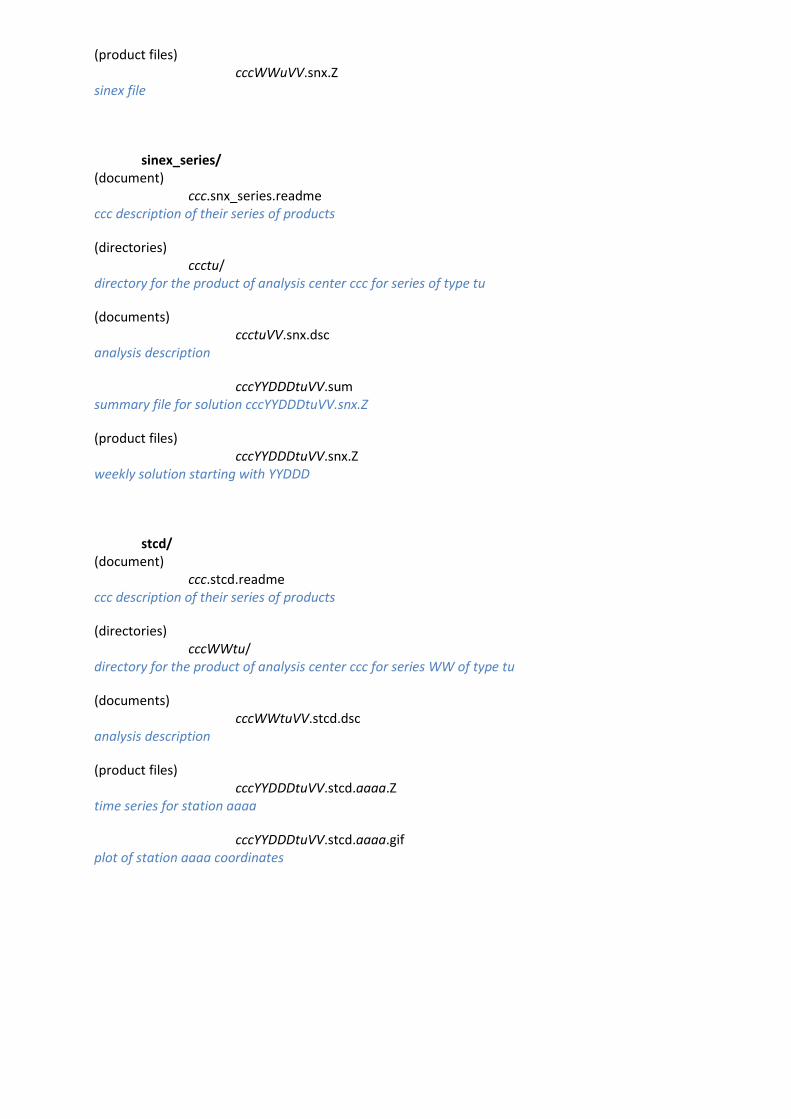
sinex file
sinex_series/
(document) ccc.snx_series.readme
ccc description of their series of products
(directories) ccctu/
directory for the product of analysis center ccc for series of type tu
(documents) ccctuVV.snx.dsc
analysis description
cccYYDDDtuVV.sum summary file for solution cccYYDDDtuVV.snx.Z
(product files) cccYYDDDtuVV.snx.Z
weekly solution starting with YYDDD
stcd/
(document) ccc.stcd.readme
ccc description of their series of products
(directories) cccWWtu/
directory for the product of analysis center ccc for series WW of type tu
(documents) cccWWtuVV.stcd.dsc
analysis description
(product files) cccYYDDDtuVV.stcd.aaaa.Z
time series for station aaaa
cccYYDDDtuVV.stcd.aaaa.gif plot of station aaaa coordinates
3. Formats
3.1 Data For DORIS data format description, see https://ids-doris.org/analysis-coordination/documents-related-to-data-analysis.html#observations
3.2 Products
3.2.1 Orbits The standard format is SP1 or SP3. See https://ids-doris.org/analysis-coordination/documents-related-to-data-analysis.html#products
3.2.2 Global Sinex solutions, DPOD solutions, Time series of Sinex solutions The Sinex format is known and accessible. See https://ids-doris.org/analysis-coordination/documents-related-to-data-analysis.html#products
3.2.3 Time series of specific products For description and data access to: -Station coordinates, -Coordinates of the TRF origin (geocenter), -Earth orientation parameters (EOP), see https://ids-doris.org/analysis-coordination/documents-related-to-data-analysis.html#products
3.2.4 Products documentation files As mentioned in section 1.3, the description of the analysis strategy must be provided with every set of products under a normalized form. Analysts are invited to use the proposed template. (See Analysis summary blank form at https://ids-doris.org/analysis-coordination/documents-related-to-data-analysis.html#analysis_centers)
Change history
Date Modifications
2004-02-19 First version
2004-07-06 updates
2007-09-19 updates
2009-02-11 updates
2010-05-10 updates
2016-11-29 updates
2017-11-29 complete review of the document
2018-05-29 add Sentinel-3B
2018-09-11 added document POD_configuration_POEF.pdf
2018-10-02 added documents Jason-3_CharacteristicsForPODprocessing.pdf and HY2_InputDataForPOD.pdf


