Embed Size (px)
Citation preview
i
MODELLING OF OPTIMAL PLACE FOR LIVING IN UNITED ARAB
EMIRATES USING GEOGRAPHICAL INFORMATION SYSTEM
SAEED MOHAMMED SULTAN AL KHAILI
A thesis submitted in fulfilment of the
requirements for the award of the Degree of
Doctor of Philosophy (Geoinformatics)
Faculty of Geoinformation and Real Estate
Universiti Teknologi Malaysia
MARCH 2013

iii
DEDICATION
To my beloved mother and father
iv
ACKNOWLEDGEMENT
Alhamdulillah. Thanks to Allah SWT, with His blessing, I have the
opportunity to complete my research. In preparing this thesis, I was in contact
with many people, researchers, academicians, and practitioners. They have
contributed toward my understanding and thoughts.
Firstly, I would like to express my deepest thanks to my supervisor, Associate
Professor Dr. Hj. Anuar Hj Ahmad and my co-supervisor Associate Professor Dr. Hj.
Hishamuddin Bin Mohd Ali for encouragement, guidance, critics and friendship. I
also wish to express my thanks to the lecturers and staff for their cooperation in
completing my thesis.
Deepest thanks and appreciation to my family, especially my parents, my
wife, my sons, my friends and others for their cooperation, encouragement,
constructive suggestion and full of support for the report completion, from the
beginning till the end.
v
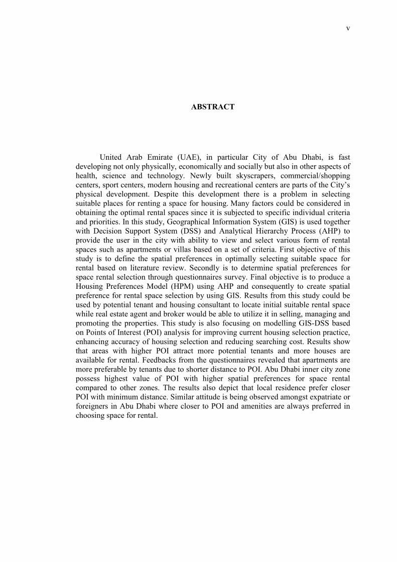
ABSTRACT
United Arab Emirate (UAE), in particular City of Abu Dhabi, is fast
developing not only physically, economically and socially but also in other aspects of
health, science and technology. Newly built skyscrapers, commercial/shopping
centers, sport centers, modern housing and recreational centers are parts of the City‘s
physical development. Despite this development there is a problem in selecting
suitable places for renting a space for housing. Many factors could be considered in
obtaining the optimal rental spaces since it is subjected to specific individual criteria
and priorities. In this study, Geographical Information System (GIS) is used together
with Decision Support System (DSS) and Analytical Hierarchy Process (AHP) to
provide the user in the city with ability to view and select various form of rental
spaces such as apartments or villas based on a set of criteria. First objective of this
study is to define the spatial preferences in optimally selecting suitable space for
rental based on literature review. Secondly is to determine spatial preferences for
space rental selection through questionnaires survey. Final objective is to produce a
Housing Preferences Model (HPM) using AHP and consequently to create spatial
preference for rental space selection by using GIS. Results from this study could be
used by potential tenant and housing consultant to locate initial suitable rental space
while real estate agent and broker would be able to utilize it in selling, managing and
promoting the properties. This study is also focusing on modelling GIS-DSS based
on Points of Interest (POI) analysis for improving current housing selection practice,
enhancing accuracy of housing selection and reducing searching cost. Results show
that areas with higher POI attract more potential tenants and more houses are
available for rental. Feedbacks from the questionnaires revealed that apartments are
more preferable by tenants due to shorter distance to POI. Abu Dhabi inner city zone
possess highest value of POI with higher spatial preferences for space rental
compared to other zones. The results also depict that local residence prefer closer
POI with minimum distance. Similar attitude is being observed amongst expatriate or
foreigners in Abu Dhabi where closer to POI and amenities are always preferred in
choosing space for rental.
vi
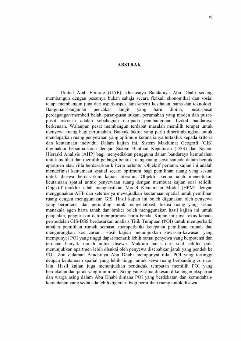
ABSTRAK
United Arab Emirate (UAE), khususnya Bandaraya Abu Dhabi sedang
membangun dengan pesatnya bukan sahaja secara fizikal, ekonomikal dan sosial
tetapi membangun juga dari aspek-aspek lain seperti kesihatan, sains dan teknologi.
Bangunan-bangunan pencakar langit yang baru dibina, pusat-pusat
perdagangan/membeli belah, pusat-pusat sukan, perumahan yang moden dan pusat-
pusat rekreasi adalah sebahagian daripada pembangunan fizikal bandaraya
berkenaan. Walaupun pesat membangun terdapat masalah memilih tempat untuk
menyewa ruang bagi perumahan. Banyak faktor yang perlu dipertimbangkan untuk
mendapatkan ruang penyewaan yang optimum kerana ianya tertakluk kepada kriteria
dan keutamaan individu. Dalam kajian ini, Sistem Maklumat Geografi (GIS)
digunakan bersama-sama dengan Sistem Bantuan Keputusan (DSS) dan Sistem
Hierarki Analisis (AHP) bagi menyediakan pengguna dalam bandaraya kemudahan
untuk melihat dan memilih pelbagai bentuk ruang-ruang sewa samada dalam bentuk
apartmen atau villa berdasarkan kriteria tertentu. Objektif pertama kajian ini adalah
mendefinisi keutamaan spatial secara optimum bagi pemilihan ruang yang sesuai
untuk disewa berdasarkan kajian literatur. Objektif kedua ialah menentukan
keutamaan spatial untuk penyewaan ruang dengan membuat kajian soal selidik.
Objektif terakhir ialah menghasilkan Model Keutamaan Model (HPM) dengan
menggunakan AHP dan seterusnya mewujudkan keutamaan spatial untuk pemilihan
ruang dengan menggunakan GIS. Hasil kajian ini boleh digunakan oleh penyewa
yang berpotensi dan perunding untuk mengenalpasti lokasi ruang yang sesuai
manakala agen harta tanah dan broker boleh menggunakan hasil kajian ini untuk
penjualan, pengurusan dan mempromosi harta benda. Kajian ini juga fokus kepada
permodelan GIS-DSS berdasarkan analisis Titik Tumpuan (POI) untuk memperbaiki
amalan pemilihan rumah semasa, memperbaiki ketepatan pemilihan rumah dan
mengurangkan kos carian. Hasil kajian menunjukkan kawasan-kawasan yang
mempunyai POI yang tinggi dapat menarik lebih ramai penyewa yang berpotensi dan
terdapat banyak rumah untuk disewa. Maklum balas dari soal selidik pula
menunjukkan apartmen lebih disukai oleh penyewa disebabkan jarak yang pendek ke
POI. Zon dalaman Bandaraya Abu Dhabi mempunyai nilai POI yang tertinggi
dengan keutamaan spatial yang lebih tinggi untuk sewa ruang berbanding zon-zon
lain. Hasil kajian juga menunjukkan penduduk tempatan memilih POI yang
berdekatan dan jarak yang minimum. Sikap yang sama dikesan dikalangan ekspatriat
dan warga asing dalam Abu Dhabi dimana POI yang berdekatan dan kemudahan-
kemudahan yang sedia ada lebih digemari bagi pemilihan ruang untuk disewa.
vii
TABLE OF CONTENT
CHAPTER TITLE PAGE
TITLE i
DECLARATION ii
DEDICATION iii
ACKNOWLEDGEMENTS iv
ABSTRACT v
ABSTRAK vi
TABLE OF CONTENT vii
LIST OF TABLES xiii
LIST OF FIGURES xv
LIST OF SYMBOLS xviii
1 INTRODUCTION 1
1.1 Background 1
1.2 Problem Statement 5
1.3 Aim of study 6
1.4 Objectives of Study 6
1.5 Scope of Study 7
1.6 Study Area 8
1.7 Significance of study 9
1.8 Thesis Outline 10
viii
2 LITERATURE REVIEW 13
2.1 Introduction 13
2.2 Geographical Information System 13
2.2.1 What is a GIS? 14
2.2.2 How does a GIS work? 14
2.3 Data Integration 14
2.4 Topological Modelling 15
2.5 The Future of GIS 15
2.6 Optimal Place Selection 15
2.7 Location 16
2.7.1 Definition 16
2.7.2 Central Place Theory 18
2.8 Business Location 20
2.9 A Comparative Business Site Location 22
2.10 Rent 22
2.11 Amenities 23
2.11.1 Amenity Value Differences 24
2.12 Choice 25
2.12.1 Definition 25
2.12.2 Theory of Choice 26
2.12.3 Residential Location Choice 26
2.12.4 Housing Choice 27
2.13 Modeling Development 27
2.14 Accessibility and Residential Location Choice 29
2.15 Theory of Allocation 29
2.16 Preference Theory 30
2.17 Analytic Hierarchy Process 31
2.18 Previous Studies Related to GIS and Locational Analysis 32
2.18.1 Importance of Location 32
2.18.2 Opportunity of Optimal Choice of Location 32
2.18.3 Decision Making in Property Selection 33
2.18.4 Power of GIS 33
2.18.5 House Hunting using GIS 34
2.18.6 Spatial Decision Support System (SDSS) 35
ix
2.18.7 Logistics of Facility Location Allocation 35
2.18.8 Business and Location Decisions 36
2.18.9 Spatial Analysis and Location Allocation 36
2.18.10 A Comparative Business Site-Location Feasibility 36
Analysis using Geographic Information Systems
and the Gravity Model
2.18.11 Residential Location Choice Modeling: 37
Accommodating Socio Demographic, School
Quality and Accessibility Effects
2.18.12 Comparing Alternative Approaches to Measuring the 38
Geographical Accessibility of Urban Health Services:
Distance Types and Aggregation-Error Issues
2.18.13 Forest Amenities and Location Choice in the Southwest 39
2.18.14 Values as Determinants of Preferences for Housing 40
Attributes
2.18.15 Amenity Value Differences in Residential Location 40
Choice among Income Groups
2.18.16 Residential Location Choice Behavior in Oxfordshire 41
2.18.17 Modeling Residential Location Choice, Workplace 42
Location Choice and Mode Choice of Two-Worker
Households in Metro Manila
2.18.18 Residential Location Preferences, Accessibility and Road 43
Proximity: Towards a better or more inclusive
infrastructure planning?
2.18.19 Accessibility Analyst: An Integrated GIS Tool for 45
Accessibility Analysis in Urban Transportation Planning
2.18.20 Stated Preference Survey on Residential Location Choice 45
and Modal Choice in Brussels
2.18.21 Transportation and Employment Accessibility in a 47
Changing Context of Metropolitan Growth: The Case of
Delhi, India
2.18.22 GIS-Based Accessibility Analysis for Network Optimal 48
Location Model, An Application for Bio-Energy Projects
of the Mineral Industry in The UK
x
2.18.23 Reconciling Household Residential Location Choices and 49
Neighborhood Dynamics
2.18.24 Towards An Integrated Model of Location Choices, 51
Activity-Travel Behaviour, and Dynamic Traffic Patterns
2.18.25 Web GIS Application in Real Estate Management 52
Web GIS Applications in Real Estate
2.19 Macroeconomic Factors and Risks 54
2.20 Spatial Quality, Location Theory and Spatial Planning 55
2.21 Analytical Hierarchy Process in House Selection 56
2.22 How Analytic Hierarchy Process Work 59
2.23 Applying The AHP To Site Selection 61
2.24 Summary 62
3 RESEARCH METHODOLOGY 63
3.1 Introduction 63
3.2 Data Set Preparation 66
3.2.1 Data from Open GIS Source GIS 66
3.2.2 Data for Abu Dhabi 68
3.3 Housing Preferences Model (HPM) 68
3.4 The AHP and House Selection 71
3.4.1 A House Selection Model Based on AHP 71
3.5 Summary 72
4 RESULTS AND ANALYSIS 73
4.1 Introduction 73
4.2 Data Analysis and Findings 74
4.3 Response Rate 74
4.4 Population 74
4.5 Statistical Results 75
4.6 Study sample 76
4.7 Findings 77
4.7.1 General Preference (Questionnaire 1) 77
xi
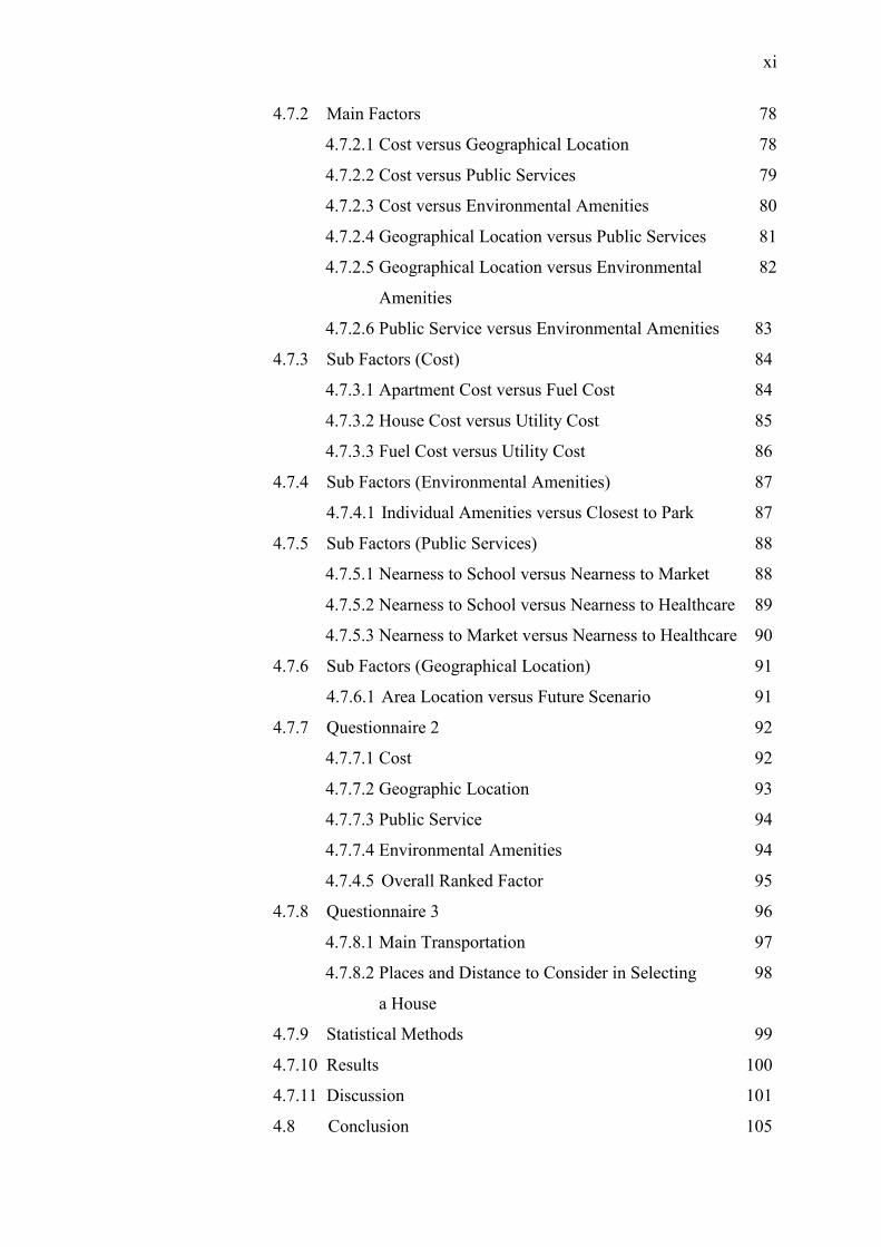
4.7.2 Main Factors 78
4.7.2.1 Cost versus Geographical Location 78
4.7.2.2 Cost versus Public Services 79
4.7.2.3 Cost versus Environmental Amenities 80
4.7.2.4 Geographical Location versus Public Services 81
4.7.2.5 Geographical Location versus Environmental 82
Amenities
4.7.2.6 Public Service versus Environmental Amenities 83
4.7.3 Sub Factors (Cost) 84
4.7.3.1 Apartment Cost versus Fuel Cost 84
4.7.3.2 House Cost versus Utility Cost 85
4.7.3.3 Fuel Cost versus Utility Cost 86
4.7.4 Sub Factors (Environmental Amenities) 87
4.7.4.1 Individual Amenities versus Closest to Park 87
4.7.5 Sub Factors (Public Services) 88
4.7.5.1 Nearness to School versus Nearness to Market 88
4.7.5.2 Nearness to School versus Nearness to Healthcare 89
4.7.5.3 Nearness to Market versus Nearness to Healthcare 90
4.7.6 Sub Factors (Geographical Location) 91
4.7.6.1 Area Location versus Future Scenario 91
4.7.7 Questionnaire 2 92
4.7.7.1 Cost 92
4.7.7.2 Geographic Location 93
4.7.7.3 Public Service 94
4.7.7.4 Environmental Amenities 94
4.7.4.5 Overall Ranked Factor 95
4.7.8 Questionnaire 3 96
4.7.8.1 Main Transportation 97
4.7.8.2 Places and Distance to Consider in Selecting 98
a House
4.7.9 Statistical Methods 99
4.7.10 Results 100
4.7.11 Discussion 101
4.8 Conclusion 105
xii
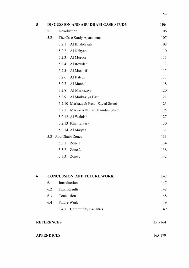
5 DISCUSSION AND ABU DHABI CASE STUDY 106
5.1 Introduction 106
5.2 The Case Study Apartments 107
5.2.1 Al Khalidiyah 108
5.2.2 Al Nahyan 110
5.2.3 Al Muroor 111
5.2.4 Al Rowdah 113
5.2.5 Al Mushrif 115
5.2.6 Al Bateen 117
5.2.7 Al Manhal 118
5.2.8 Al Markaziya 120
5.2.9 Al Markaziya East 121
5.2.10 Markazyah East, Zayed Street 123
5.2.11 Markaziyah East Hamdan Street 125
5.2.12 Al Wahdah 127
5.2.13 Khalifa Park 130
5.2.14 Al Maqtaa 131
5.3 Abu Dhabi Zones 133
5.3.1 Zone 1 134
5.3.2 Zone 2 138
5.3.3 Zone 3 142
6 CONCLUSION AND FUTURE WORK 147
6.1 Introduction 147
6.2 Final Results 148
6.3 Conclusion 148
6.4 Future Work 149
6.4.1 Community Facilities 149
REFERENCES 151-164
APPENDICES 165-179
xiii
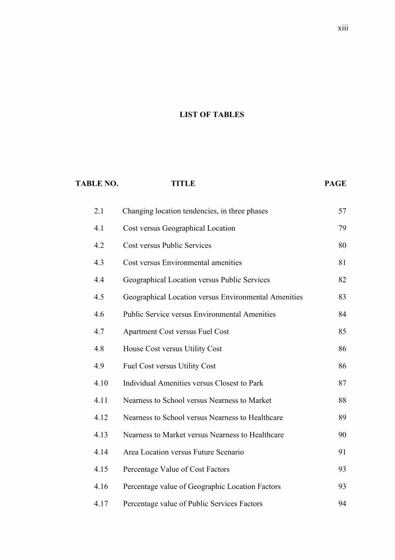
LIST OF TABLES
TABLE NO. TITLE PAGE
2.1 Changing location tendencies, in three phases 57
4.1 Cost versus Geographical Location 79
4.2 Cost versus Public Services 80
4.3 Cost versus Environmental amenities 81
4.4 Geographical Location versus Public Services 82
4.5 Geographical Location versus Environmental Amenities 83
4.6 Public Service versus Environmental Amenities 84
4.7 Apartment Cost versus Fuel Cost 85
4.8 House Cost versus Utility Cost 86
4.9 Fuel Cost versus Utility Cost 86
4.10 Individual Amenities versus Closest to Park 87
4.11 Nearness to School versus Nearness to Market 88
4.12 Nearness to School versus Nearness to Healthcare 89
4.13 Nearness to Market versus Nearness to Healthcare 90
4.14 Area Location versus Future Scenario 91
4.15 Percentage Value of Cost Factors 93
4.16 Percentage value of Geographic Location Factors 93
4.17 Percentage value of Public Services Factors 94
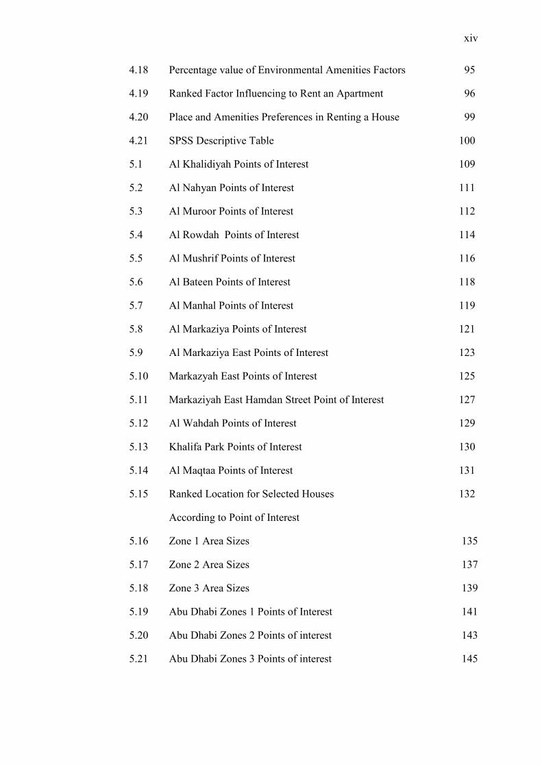
xiv
4.18 Percentage value of Environmental Amenities Factors 95
4.19 Ranked Factor Influencing to Rent an Apartment 96
4.20 Place and Amenities Preferences in Renting a House 99
4.21 SPSS Descriptive Table 100
5.1 Al Khalidiyah Points of Interest 109
5.2 Al Nahyan Points of Interest 111
5.3 Al Muroor Points of Interest 112
5.4 Al Rowdah Points of Interest 114
5.5 Al Mushrif Points of Interest 116
5.6 Al Bateen Points of Interest 118
5.7 Al Manhal Points of Interest 119
5.8 Al Markaziya Points of Interest 121
5.9 Al Markaziya East Points of Interest 123
5.10 Markazyah East Points of Interest 125
5.11 Markaziyah East Hamdan Street Point of Interest 127
5.12 Al Wahdah Points of Interest 129
5.13 Khalifa Park Points of Interest 130
5.14 Al Maqtaa Points of Interest 131
5.15 Ranked Location for Selected Houses 132
According to Point of Interest
5.16 Zone 1 Area Sizes 135
5.17 Zone 2 Area Sizes 137
5.18 Zone 3 Area Sizes 139
5.19 Abu Dhabi Zones 1 Points of Interest 141
5.20 Abu Dhabi Zones 2 Points of interest 143
5.21 Abu Dhabi Zones 3 Points of interest 145
xv
LIST OF FIGURES
FIGURE NO. TITLE PAGE
1.1 Ariel Photo of Khalidiah, Abu Dhabi 1966 2
1.2 The Main Street in Abu Dhabi 1966 2
1.3 Abu Dhabi Corniche 1970 3
1.4 Abu Dhabi Corniche 2007 3
1.5 Study Area 9
2.1 Hierarchy Structure of the Decision Making Process 31
2.2 Factors Influencing Location Choice of Households 44
2.3 UrbanSim Models in order of their runs 50
2.4 A Frameworks for Developing GIS Software 53
2.5 Presumed Relationship between Soico-economic 56
2.6 Decision Flowchart for Spatial Multi Criteria Analysis 58
2.7 Analytic Hierarchy Process 60
3.1 Flow Chart of Activities 65
3.2 Road layer of Abu Dhabi Island 67
3.3 Spatial Point of Interest 67
3.4 Some Location of Point of Interest 70
4.1 Cost versus Geographical Location 78
4.2 Cost versus Public Services 79
4.3 Cost versus Environmental amenities 80
xvi
4.4 Geographical Location versus Public Services 81
4.5 Geographical Location versus Environmental Amenities 82
4.6 Public Service versus Environmental Amenities 83
4.7 Apartment Cost versus Fuel Cost 84
4.8 House Cost versus. Utility Cost 85
4.9 Fuel Cost versus Utility Cost 86
4.10 Individual Amenities versus Closest to Park 87
4.11 Nearness to School versus Nearness to Market 88
4.12 Nearness to School versus Nearness to Healthcare 89
4.13 Nearness to Market versus Nearness to Healthcare 90
4.14 Area Location versus Future Scenario 91
4.15 Main Transportation 97
4.16 Pair Wise Method 101
4.17 Direct Weight Method Median Values 102
4.18 Right Choice DSS (Using Mean Values) 103
4.19 Abu Dhabi Map from Open Source (GPSMapEdit) 104
4.20 Case Study Houses with Buffer 1000 m 104
5.1 Abu Dhabi Buffer 1 km 107
5.2 Al Khalidiyah 109
5.3 Al Nahyan 110
5.4 Al Muroor 112
5.5 Al Rowdah 114
5.6 Al Mushrif 116
5.7 Al Bateen 117
5.8 Al Manhal 118
5.9 Al Markaziya 120
5.10 Al Markaziya East 122
xvii
5.11 Markazyah East, Zayed Street 124
5.12 Markazyah East, Hamdan Street 126
5.13 Al Wahdah 129
5.14 Khalifa Park 130
5.15 Al Maqtaa 131
5.16 Abu Dhabi Zones 133
5.17 Abu Dhabi Zone 1 134
5.18 Abu Dhabi Zone 1 Points of Interest 136
5.19 Abu Dhabi Zone 2 139
5.20 Abu Dhabi Zone 2 Points of Interest 140
5.21 Abu Dhabi Zone 3 143
5.22 Abu Dhabi Zone 3 Points of Interest 144
6.1 Abu Dhabi Community Facilities 150
xviii
LIST OF SYMBOLS
UAE - United Arab Emirates
DSS - Decision Support System
GIS - Geographic Information System
AHP - Analytic Hierarchy Process
HPM - Housing Preferences Model
POI - Point Of Interest
IRS - Internal Revenue Service's
CNL - Cross-Nested Logic
SDSS - Spatial Decision Support System
PHAs - Public Housing Authorities
MMUTIS - Metro Manila Urban Transportation Integration Study
Delhi NCT - National Capital Territory of Delhi
SimTRAVEL - Simulator of Transport
WGIS - Web GIS Application
AVM - Automated Valuation Model
CSF - Critical Success Factor
GP - Goal Programming Model
UTM - Universal Transverse Mercator
GCS - Geographic Coordinate System:

xix
WGS - World Geodetic System
Std dev - Standard Deviation
SPSS - Statistical Package for Social Sciences
AED - United Arab Emirates Dirham
ADNOC - Abu Dhabi National Oil Company
SQ FT - Square Foot
KM - Kilometer
Dhs - Dirham
SKMC - Sheikh Khalifa Medical City
BD - Bed Room
AISA - American International School
CBD - Central Business District
NMC - New Medical Centre
ADWC - Abu Dhabi Women's College
HCT - Higher Colleges of Technology
ATM - Automated Teller Machine
HTTP - Hypertext Transfer Protocol
PHP - Hypertext Preprocessor
DB - Data Base
SEF - Search Engine Friendly
URL - Universal Resource Locator
HTML - Hypertext Markup Language
RDBMS - Relational Database Management System
SQL - Structured Query Language
1
CHAPTER 1
INTRODUCTION
1.1 Background
This chapter introduces the United Arab Emirates (UAE) by a short
breakdown of its history, politics, economy and how these factors affect the real
estate market (United Arab Emirates, 2010). In the middle of the 20th
century, the
economy of Abu Dhabi sustained mainly through camel herding, production of dates
and vegetables at the inland oases of Al Ain and Liwa, fishing and pearl diving off
the coast of Abu Dhabi city, which was occupied mainly during the summer months.
Most residences in Abu Dhabi city at this time were constructed of palm fronds
(barasti), with the wealthier families occupying huts made of mud. The growth of
cultured pearl industry in the first half of the twentieth century had more or less
interrupted the local residents‘ cash earning activity as the pearls represented the
largest export and main source of income for them.
In 1939, Sheikh Shakhbut Bin Sultan Al Nahyyan approved petroleum
concessions, and oil was first found in 1958. At first, earnings from oil had a
marginal impact. A few low rise concrete buildings were only erected in 1961
together with the first paved road.
2
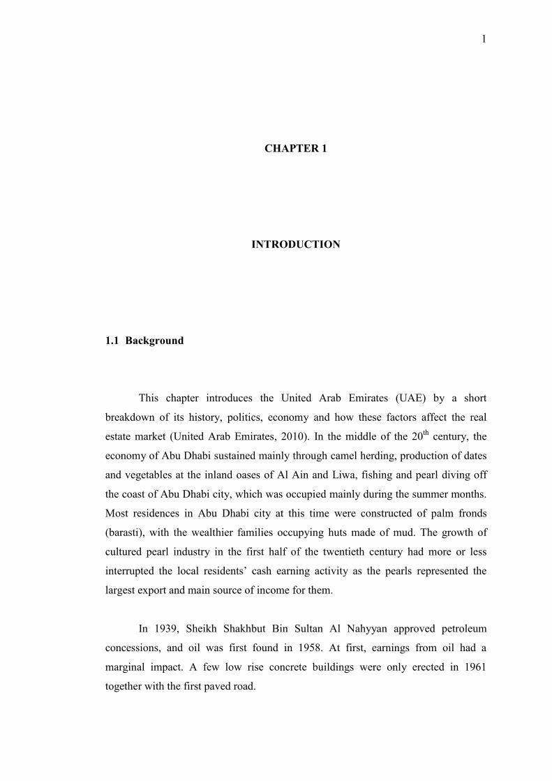
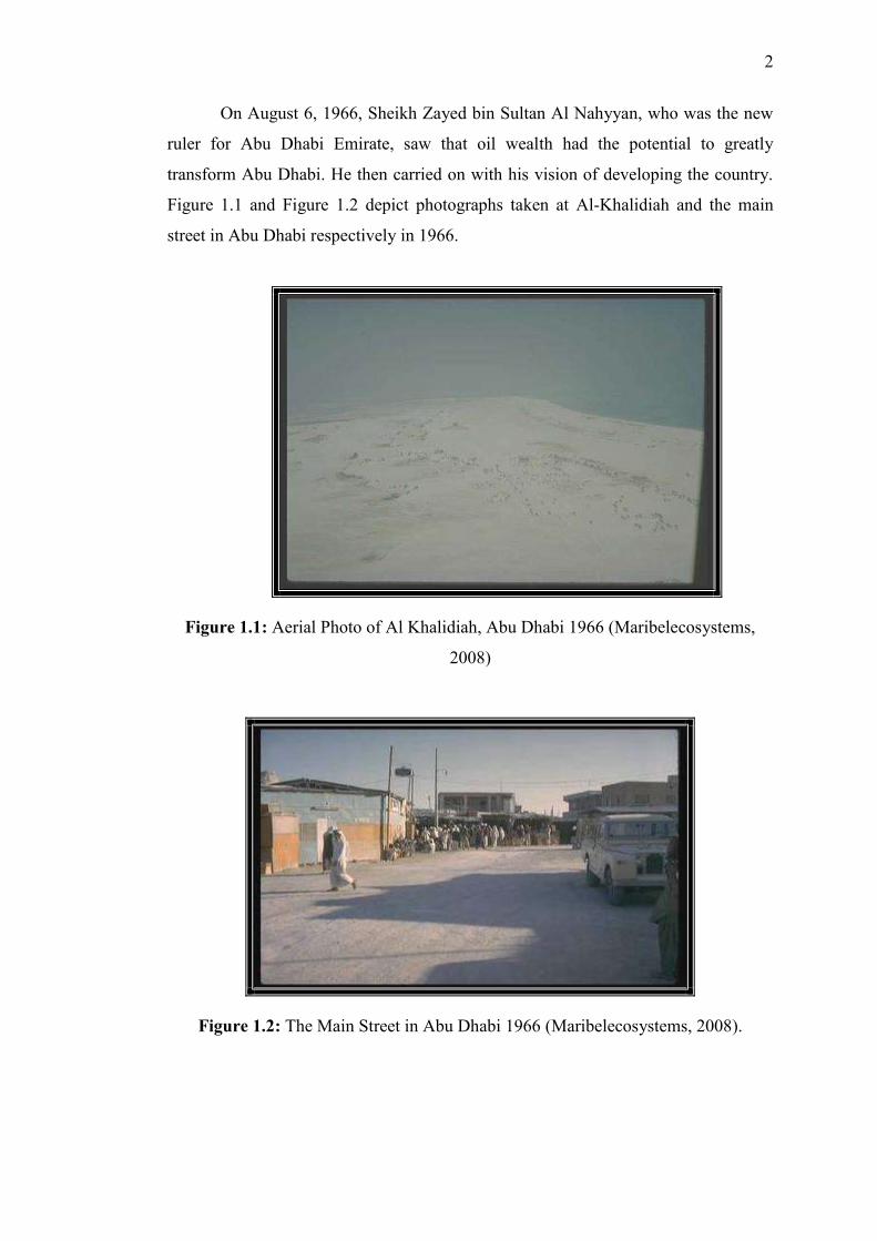
On August 6, 1966, Sheikh Zayed bin Sultan Al Nahyyan, who was the new
ruler for Abu Dhabi Emirate, saw that oil wealth had the potential to greatly
transform Abu Dhabi. He then carried on with his vision of developing the country.
Figure 1.1 and Figure 1.2 depict photographs taken at Al-Khalidiah and the main
street in Abu Dhabi respectively in 1966.
Figure 1.1: Aerial Photo of Al Khalidiah, Abu Dhabi 1966 (Maribelecosystems,
2008)
Figure 1.2: The Main Street in Abu Dhabi 1966 (Maribelecosystems, 2008).
3
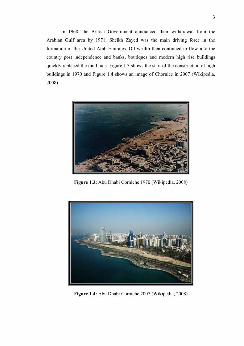
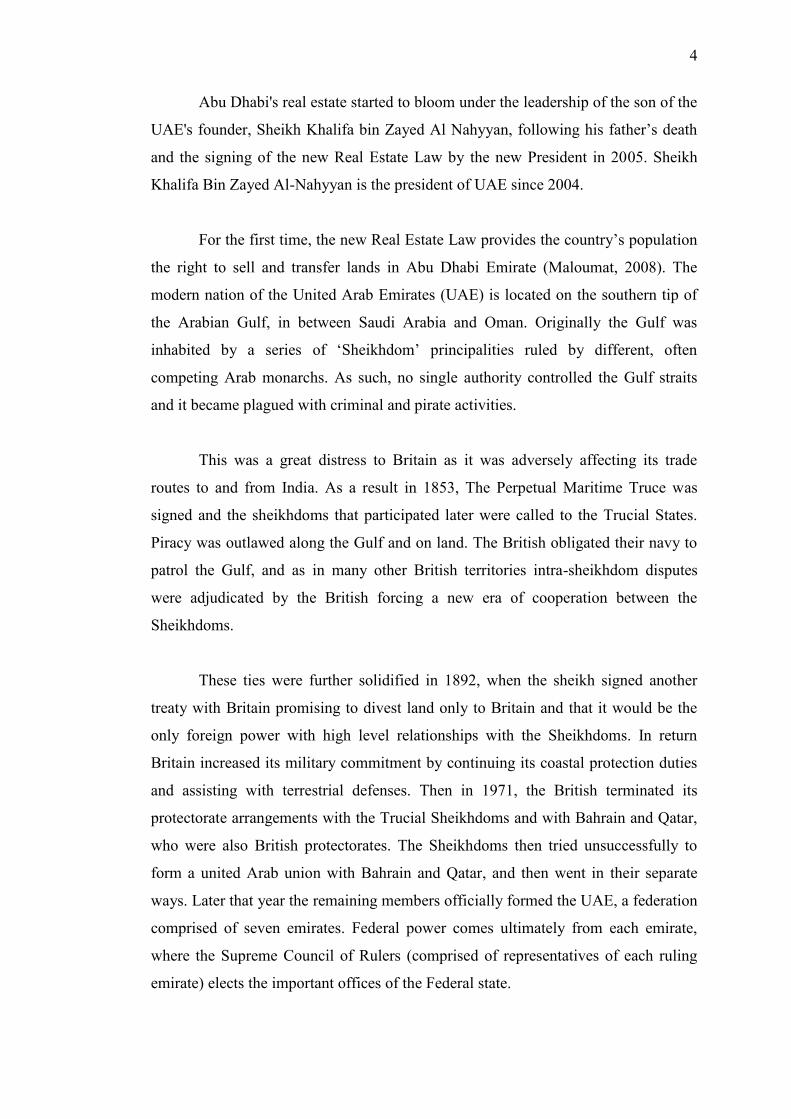
In 1968, the British Government announced their withdrawal from the
Arabian Gulf area by 1971. Sheikh Zayed was the main driving force in the
formation of the United Arab Emirates. Oil wealth then continued to flow into the
country post independence and banks, boutiques and modern high rise buildings
quickly replaced the mud huts. Figure 1.3 shows the start of the construction of high
buildings in 1970 and Figure 1.4 shows an image of Chornice in 2007 (Wikipedia,
2008)
Figure 1.3: Abu Dhabi Corniche 1970 (Wikipedia, 2008)
Figure 1.4: Abu Dhabi Corniche 2007 (Wikipedia, 2008)
4
Abu Dhabi's real estate started to bloom under the leadership of the son of the
UAE's founder, Sheikh Khalifa bin Zayed Al Nahyyan, following his father‘s death
and the signing of the new Real Estate Law by the new President in 2005. Sheikh
Khalifa Bin Zayed Al-Nahyyan is the president of UAE since 2004.
For the first time, the new Real Estate Law provides the country‘s population
the right to sell and transfer lands in Abu Dhabi Emirate (Maloumat, 2008). The
modern nation of the United Arab Emirates (UAE) is located on the southern tip of
the Arabian Gulf, in between Saudi Arabia and Oman. Originally the Gulf was
inhabited by a series of ‗Sheikhdom‘ principalities ruled by different, often
competing Arab monarchs. As such, no single authority controlled the Gulf straits
and it became plagued with criminal and pirate activities.
This was a great distress to Britain as it was adversely affecting its trade
routes to and from India. As a result in 1853, The Perpetual Maritime Truce was
signed and the sheikhdoms that participated later were called to the Trucial States.
Piracy was outlawed along the Gulf and on land. The British obligated their navy to
patrol the Gulf, and as in many other British territories intra-sheikhdom disputes
were adjudicated by the British forcing a new era of cooperation between the
Sheikhdoms.
These ties were further solidified in 1892, when the sheikh signed another
treaty with Britain promising to divest land only to Britain and that it would be the
only foreign power with high level relationships with the Sheikhdoms. In return
Britain increased its military commitment by continuing its coastal protection duties
and assisting with terrestrial defenses. Then in 1971, the British terminated its
protectorate arrangements with the Trucial Sheikhdoms and with Bahrain and Qatar,
who were also British protectorates. The Sheikhdoms then tried unsuccessfully to
form a united Arab union with Bahrain and Qatar, and then went in their separate
ways. Later that year the remaining members officially formed the UAE, a federation
comprised of seven emirates. Federal power comes ultimately from each emirate,
where the Supreme Council of Rulers (comprised of representatives of each ruling
emirate) elects the important offices of the Federal state.
5
1.2 Problem Statement
There is a common saying that says a picture is worth a thousand words (Can,
1998). GIS is a tool used in map making and as a visualization aid, for certain
designated areas. In real estate, it is understandable that location is a fundamentally
important criterion in determining the current and potential value of a property.
Spatial factor is then vital in influencing a decision making process and GIS is
undoubtedly useful in this aspect (Zeng and Zhou, 2001). The purpose of this study
is to develop house preference model (HPM) for the point of interest (POI) and its
impact to real estate using GIS.
Finding a place to live in is a critical choice because the decision made could
not be changed due to the high price of the property and its location. This study is
conducted to help people to make a decision in renting a property that has the best
location and the best price according to their needs and affordability. This could also
be a ground work in assisting clients to select optimal home selection.
Location is one of the most significant factors in choosing a real estate object
(e.g. flat, office, building parcel). Surroundings characteristics of the real estate
including ecological indicators, traffic location and level of infrastructure
development should be given due attention by developers and realtors. GIS makes
possible mapping of the location of surrounding objects and fundamental analysis of
its location (Kononova and Nitonova, 2005).
Most clients experience frustration, exhaustion and poor satisfaction.
Location does tremendously play a major role in the decision making process.
Today, buyers may get the right product with the right price but may not necessarily
get the location they desire. This is very discouraging to the buyers, hence, resulting
in retrievals from the market. This phenomenon is mostly due to the absence of a
comprehensive database about the apartment promoters and their projects and most
buyers prefer to choose from a variety of choices offered to them (Raghavendran,
2001).
6
The managing director of a property management company (Asteco), Andrew
Chambers, once in 3rd
of May 2009 told the Gulf News that ―at present there is an
acute shortage of accommodation with quality at an affordable price range and there
have been significant increases in rents‖. According to data from Asteco, the average
rent (June 2006) of a one-bed-room apartment in the capital is Dh 53,000, two-bed-
room apartments are Dh76,000 and three-bed-room apartments are Dh127,000. From
June 2005 to June 2006, rents have increased by 33 per cent for single-bedroom
apartments, 23 per cent for two bedrooms and 30 per cent for three bedrooms.
However, there are apartments in some areas where rents are lower, but they are
rising, fuelling inflationary pressures. Apartment and houses renting has a high
demand and a low supply rate in Abu Dhabi.
1.3 Aim of Study
The aim of this research is to model House Preferences Model (HPM) for the
Point of Interest (POI) in the study area, and its impact to real estate, by using
geographical information system (GIS) to find optimal place to rent in United Arab
Emirates, based on a case study of Abu Dhabi Island. This is carried out by
integrating the existing decision support system, using analytical hierarchy process
(AHP), and GIS operating environment in ArcGIS.
1.4 Objectives of Study
The aim of this study is fulfilled through the following objectives:
7
i. To define the spatial preferences to select optimal house to rent based on
literature review and questionnaires.
ii. To determine spatial preferences for housing rental market survey.
iii. To develop housing preferences model (HPM) using AHP and spatial
preference for house selection by using Geographic information systems.
The model and map result from the study will serve two applications:
i. For purchaser, renter and individual:
As a consultant to locate optimal initial potential for the house area
and evaluate available choices by weighting functions according to
the customers' preferences.
ii. For real estate agent and broker:
As a tool to sell, manage and promote properties.
1.5 Scope of Study
The scope of this study is to modeling GIS-DSS for POI analysis for optimal
house selection to improve the current house selection practice, improve the accuracy
and reduce the searching cost. The location enriched by POI database; allows users
to view and analyze selected POI data in Abu Dhabi area.
This study focuses on the environment surrounding the house that affects the
selection of the house such as schools, universities, hospitals, parks, shopping centers
and other point of interest which people need to live their daily life. By using
Distance Analysis Functions in ArcGIS, user could be assisted to choose a house that
has the biggest weight and to rank the entire selections from most likely match to
lowest match.
8
1.6 Study Area
Abu Dhabi Island in the northwest of UAE was chosen as the area of study,
which is surrounded by Arabian Gulf and connected to the main land by Al Maqqta
Bridge (main bridge) and Mussafah Bridge and a highway to other cities. Abu Dhabi
is the capital of United Arab Emirates with a population of 896,751 calculated in
2009 (world-gazetteer.com). Abu Dhabi is one of the most popular emirates to
purchase or rent a property due to many reasons including affluent reputation, coastal
location and enticing weather. Rental prices have risen considerably in the past years
because the demand currently outweighs the supply. The city is modern and it is
growingly creating its own distinctive style. Abu Dhabi is laid out on a grid pattern
and there is a very high density of buildings along the seafront area known as the
corniche, where it is normal to see 20-storey, high-rise buildings. Apartment renting
has a high demand and a low supply rate in Abu Dhabi, which sees a tremendous
hike in rental prices. Serviced apartments are scarce and far between, situated within
high-rise blocks. These apartments are usually fully furnished. There is no public
transport system that usually passed through these serviced apartments, which means
that all renters should individually own a car (abu-dhabi.world-guides.com, 2010).
Abu Dhabi lies on a T-shaped island jutting into the Arabian Gulf from the central
western coast. It covers an area of 16.5 x 12 km with a diversified resident density
and constantly growing property market. Figure 1.5 shows the study area.
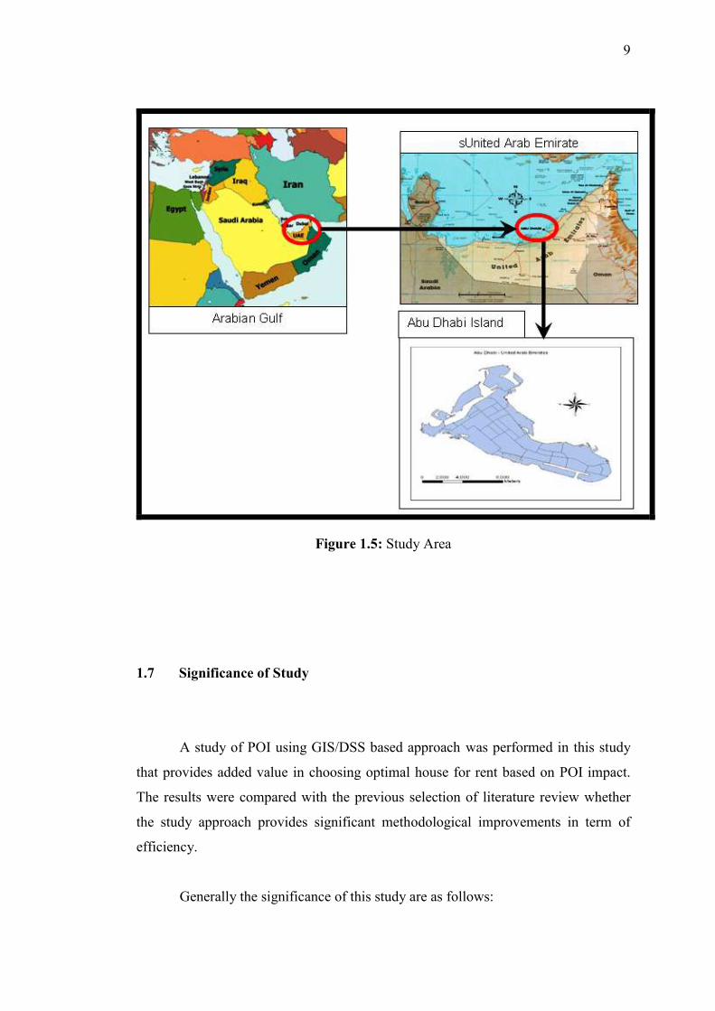
9
Figure 1.5: Study Area
1.7 Significance of Study
A study of POI using GIS/DSS based approach was performed in this study
that provides added value in choosing optimal house for rent based on POI impact.
The results were compared with the previous selection of literature review whether
the study approach provides significant methodological improvements in term of
efficiency.
Generally the significance of this study are as follows:
10
i. The study could provide better understanding of GIS in general, GIS application
in real estate, optimal house selection and the relative potential location of places
in Abu Dhabi Island.
ii. The House Preferences Model (HPM) will be used as a decision support tool for
optimal house selection by agent broker in Abu Dhabi Island to promote their
properties by showing the impacts of POI in Geographical information systems
with selected places.
iii. The (HPM) Model may be used to delineate Abu Dhabi zones that are valuable to
places of interest impact.
iv. The Model may be used to rank Abu Dhabi zones according to POI impact. The
results from the analysis may be used to clarify the spatial preferences, which in
certain configuration leads to a longer or shorter distance of POI impact and if
selecting parameters plays a role.
v. The Model produced from this research could be used in the long term for other
rapid growing cities and economy like Abu Dhabi.
1.8 Thesis Outline
This thesis is structured and organized in the way that will guide the reader
from the basic problems and concepts up to comprehensive understanding of GIS
and DSS implementation.
Chapter 1
Chapter one gives some introductory information about the problem, aim,
objectives and the scope of the study. Also this chapter highlights the significance of
studying GIS and DSS with regard to select a house in Abu Dhabi for renting.
11
Chapter 2
This chapter presents mainly the literature review, covering previous
experiences or studies with the emphasis of GIS and implementation of DSS.
Chapter 3
This chapter discusses the research methodology used, a description of the
respondents, the procedures and statistical treatment utilized in analyzing the
gathered data.
Chapter 4
This chapter deals with the analysis of data. The results of the analysis were
organized, prioritized accordingly and discussed.
Chapter 5
This chapter discusses Abu Dhabi case study as a testing and implementation
of distance methods of POI in Abu Dhabi. Also this chapter discusses the analysis
and results of testing and applying POI and its impact on choosing the optimal place.

12
Chapter 6
This chapter includes the findings of this study. Finally, some
recommendations are given for future work in this field.
151
REFERENCES
Aleid, E. B. (2004). Regions and fiscal federalism. 44th European Regional Science
Association conference, 25-29 August 2004, Porto, Portugal.
Andrienko, N. and Andrienko, G. (2001). Intelligent Support for Geographic Data
Analysis and Decision Making in the Web, Journal of Geographic
Information and Decision Analysis, Vol. 5, No. 2, pp. 115-128,Germany
Angelo, M. and Christopher, N. (2005). Modeling residential location choice,
workplace location choice and mode choice of two-worker house hold in
metro Manila, University of the Philippines, Philippines, Proceedings of the
Eastern Asia Society for Transportation Studies, Vol. 5, pp. 1167 - 1178,
2005.
Apparicio, P, Abdelmajid, M. Riva, M. and Shearmur, R. (2008). Comparing
alternative approaches to measuring the geographical accessibility of urban
health services: Distance types and aggregation-error issues, Published online
2008 February 18. DOI: 10.1186/1476-072X-7-7, International Journal of
Health Geographics 2008, 7:7
Assink, M. and Groenendijk, N. (2009). Spatial quality, location theory and spatial
planning. Regional Studies Association Annual Conference 2009.
Understanding and Shaping Regions: Spatial, Social and Economic Futures
Leuven, Belgium, April 6-8, 2009.

152
Ball, J. and Srinibasan, V. C. (1994). Using the Analytic Hierarchy Process in House
Selection, The Journal of Real Estate Research, 9: 69-85.
Becker, S. G. (1965). A theory of the allocation of time. The Economic Journal,
Vol. 75, No. 299, September 1965.
Can, A. (1998). GIS and Spatial Analysis of Housing and Mortgage Markets,
Journal of Housing Research, Volume 9, Issue 1, Fannie Mae Foundation.
Chengda, L., Lingkui, M. and Heping, P. (2001). Applications and research on GIS
for the real estate. 22nd Asian Conference on Remote Sensing, Singapore
Church, R. L., (2002). Geographical information systems and location science.
Computers & Operations Research, 29:pp-541-62.
Coolen, H. and Hoekstra, J. (2001). Values as determinants of preferences for
housing . Journal of Housing and the Built Environment, 16, pp. 285-306.
Cragg, M. and Kahn, M. (1997). New Estimates of Climate Demand: Evidence from
Location Choice. J.Urban Econ. 42,2(1997):261-284.
David, E. C., Michelbrink, L., A and Metz, W. C., (1997). Nuclear Power Plants and
Residential Housing Prices. Growth and Change, Volume 28, Number 4, Fall
1997, pp. 496-519, Blackwell Publishing US.
Davies, P. S., Greenwood, M. J., and Li, H.. (2001). A Conditional Logit Approach
to U.S. State-to-State Migration. J. Regional Sci. 41, 2(2001):337-360.
Dong, J. (2008). GIS and Location Theory Based Bioenergy Systems Planning. A
thesis presented to the University of Waterloo in fulfillment of the thesis
153
requirement for the degree of Master of Applied Science in Systems Design
Engineering, Waterloo, Ontario, Canada, 2008.
Du, Y. (2009). Optimal-location queries over spatial databases. Computer Science
Dissertations. Paper 5. http://hdl.handle.net/2047/d10019212.
Dubuc, S. (2007). GIS-based accessibility analysis for network optimal location
model. Cybergeo European Journal of Geography (online), Systems,
Modelling, Geostatistics, Document 407, put online Nov. 26,2007. Electronic
Reference, URL: http://cybergeo.revues.org/index12653.html
Duggal, N. (2007). Retail Location Analysis: A Case Study of Burger King &
McDonald’s in Portage & Summit Counties. Masters Thesis. Kent State
University, Ohio.
Feinberg, S. (2007). Location Theory. In Reinert and Rajan (eds.), The Princeton
Encyclopedia of the World Economy. Princeton, NJ: Princeton University
Press.
Frankel, J. A. (2008). Commodity Prices and Monetary Policy. Asset Prices and
Monetary Policy, Ed., Campbell, J.Y., Chicago: University of Chicago Press.
Gayda, S. (1998). Stated preference survey on residential location choice and modal
choice in Brussels, Presented in Antwerpen during the WCTR in July 1998
within the framework: Survey and calibration - Modelling with stated
preference data.
Ghosh, Avijit and Rushton (1987). Spatial Analysis and Location-Allocation Models.
Van Nostrand Reinhold Company, New York, USA
154
Glenn, S.J. (2007). Case Study of Development in the County Road, 241
Jonesvillealachua, Florida Corridor. Ph.D. Thesis. University of Florida.
Guo, J. and Bhat, C. (2002). Residential Location Choice Modeling: Accommodating
Sociodemographic, School Quality and Accessibility Effects.
http://www.ce.utexas.edu/prof/bhat/ABSTRACTS/residential.pdf, Accessed
on 1 June 2008.
Graves, P. E., and Linneman, P. D. (1979). Household Migration: Theoretical and
Empirical Results. J. Urban Econ. 6, 3(1979):383-404.
Gunningham, C., Williams, P. and Amristar, S. (2002). Delving into Real Estate with
A New Online GIS Technology. Australia’s Premiere GIS Conference,
Australia
Hamilton, L. and Guin, K. (2006). Understanding how families choose schools. In
J.Betts and T. Loveless (Eds). Getting Choice Right. Washington, DC. The
Brookings Institute.
Hammond, J. S. (1967). Better decisions with preference theory. Harvard Business
Review, November - December pp 123 - 141.
Hammond, J. S. (1967). Better Decisions with Preference Theory . Harvard Business
Review. Publication date: Nov 01, 1967. Prod.
(http://hbr.org/product/better-decisions-with-preference-theory/an/67604-
PDF-ENG)
Hand, M. S., Thacher, J. A., McCollum, D. W. and Berrens, R. P., (2008). Forest
amenities and location choice in the southwest. Journal of Agricultural and
Resources Economics, 33(2):232-253.
155
Handy, S. L. and Niemeier, D. A. (1997). Measuring Accessibility: an exploration of
issues and alternatives. Environment and Planning, 29, 1175-1194.
Hoffman, J. J., Schniederjans, M.J. and G.S. Sirmans. (1990). A Multi-Criteria
Model for Corporate Property Evaluation, The Journal of Real Estate
Research 5, 285-300.
Ingrid, A., Schaefer, R. and Dominick, T. D. (2010). The Gulf States: An
Embarrassment of Oil Riches. Allianz Dresdner Economic Research (http://
www.allianz.com).
Johnson, M. P. (2002). The Pittsburgh Housing eCounselor: Using Information
Technology and Management Science to Help Housing Choice Voucher
Program Participants Choose Better Homes and Communities, Association of
Public Policy Analysis and Management Fall National Conference,
November 9, 2002, Dallas, Texas.
Kim, J.H. (2007). Amenity Valuation and Housing Market Segmentation School of
Social Sciences, University of Ulsan, Korea Strategic Technology, 2007.
IFOST 2007. International Forum on Issue Date: 3-6 Oct. 2007, pp 272 - 275
Kononova, M. Y and Nikonova, O.G. (2005). GIS – based DSS for sustainable
infrastructures and management of tourism in the Leningrad Region St
Petersburg State Polytechnic University, St Petersburg, Russia.
Król, D. (2007). Fuzzy System Model to Assist with Real Estate Appraisals. Springer,
Berlin, Germany.
156
Lankford, H. and Wyckoff, J.(2006). The Effect of School Choice and Residential
Location on the Racial Segregation of Students, Advances in Applied
Microeconomics, Issue 14, pp.185 – 239.
Liu, S. and Zhu, X. (2004). Accessibility Analyst: an integrated GIS tool for
accessibility analysis in urban transportation planning. Journal of Transport
Geography Volume 12, Issue 2, June 2004, pp 89-101.
Malczewski, J. (1999). GIS and Multicriteria Decision Analysis, John Wiley and
Sons, 392 pp., New York, NY.
Malczewski, J., (2004). GIS- based land use suitability analysis: a critical overview,
Progress in Planning, 62, pp-3-65.
Maloir, C., Tillema, T. and Arts J. (2009). Residential location preferences,
accessibility and road proximity: towards a better or more inclusive
infrastructure planning? Colloquium Vervoersplanologisch Speurwerk,
Antwerpen, 19-20 November 2009.
McFadden, D. (1978). Modeling the choice of residential location.
In Karlqvist, A., Lundqvist, L., Snickars, F., and Wiebull, J., (Eds). Spatial
Interaction Theory and Planning Models, pages 75-96. North Holland,
Amsterdam.
Mills, E. S. (1985). Open Housing Laws as Stimulus to Central City Employment,
Journal of Urban Economics, March 1985, 17:2, 88-184.
Molin, E. and Timmermans, H. (2003). Accessibility considerations in residential
choice decisions: Accumulated evidence from the Benelux. Paper presented
157
at the 82nd Annual Transportation Research Board Meeting, Washington
DC.
Nasirin, S. (1999). GIS Implementation in UK Retail Organizations in Malaysia.
Geoinformatics and Socioinformatics. The Proceedings of Geoinformatics'99
Conference Ann Arbor, 19-21 June, 1999, pp. 1-15.
Pagliara, F., Preston J. and Kim J.H. (2002). Residential location choice behaviour in
Oxfordshire, Proceedings of the conference European Transport Conference,
Cambridge, 9-11.
Patrick, A.V. (1996). Use of GIS Based DSS for Sustainable Development:
Experience and Potential, IT in Developing Countries Volume 6, No. 2, April
1996 China
Pearson, J. (2007). A Comparative Business Site-Location Feasibility Analysis using
Geographic Information Systems and the Gravity Model. Volume 9, Papers
in Resource Analysis. Saint Mary‘s University of Minnesota Central Services
Press, 10 pp.
Pendyala, R. M., Chiu, Y.C., Hickman, M., Waddell, P., and Gardner, B. (2010).
Towards an Integrated Model of Location Choices, Activity-Travel Behavior,
and Dynamic Traffic Patterns: Paper submitted for 2010 Innovations
Conference March 28-31, 2010, in Baltimore, Maryland, USA.
http://www.urbansim.org/pub/Research/Urban
Continuum/WebHome/ITM2010_SimTRAVEL_Pendyalaetal.pdf.
Peterson, K. (1998). Development of Spatial Decision Support Systems for
Residential Real Estate. Journal of Housing Research. Volume 9, Issue 1.
158
Raghavendran, S. (2001). Decision support system for promotion of residential
apartments in Chennai city using GIS, Map India 2001. India.
Rice, M. T. (2005). Intellectual Property Control for Maps and Geographic Data.
PhD. Thesis. University of California, Santa Barbara.
Saaty, T.L. (2008), Decision making with the analytic hierarchy process Int. J.
Services Sciences, Vol. 1, No. 1, pp.83–98 ,2008 83 University of Pittsburgh,
Pittsburgh, PA 15260, USA.
Saaty, T.L. and Kearns, K. (1985). Analytical Planning: The Organization of
Systems, Oxford: Pergamon Press. Translated to Russian (1991). Reprinted
(1991) Pittsburgh: RWS Publications.
Saeed Mohammed Sultan Al Khaili (2007). Color-Coded GIS MAP for Buildings
Rent Prices in Abu Dhabi. Unpublished Master Thesis, United Arab Emirates
University.
Schmenner, R.W. (1982). Making business location decisions. Prentice-Hall, New
Jersey, USA.
Schniederjans, M.J., Hoffman, J. J. and Sirmans, G.S. (1995). Using global
programming and analytical hierarchy process in house selection. Journal of
Real Estate Finance and Economics, 11: 167-176.
Simpson, W. (1980). A Simultaneous Model of Workplace and Residential Location
Incorporating Job Search. Journal of Urban Economics 8, 330-49.
159
Smith, C.A., and Webb, J.R. (1997). Using GIS to Improve Estimates of Future
Retail Space Demand, Appraisal Journal, Volume 65, Number 4, October,
1997, pp. 337-341. USA.
Stetser, B. (2007). The Case for Exchange Rate Flexibility in Oil-Exporting
Economies. Policy Brief, Petersen Institute for International Economics.
Sule, D. R. (2001). Logistics of facility location and allocation. Marcel Dekker, New
York, USA
Susan, F. (2001). Location theory. Rutgers Business School (World economy
location theory).
Susan, F. and Michael K, M. (2001). U.S. Canada Trade Liberalization and MNC
Production Location. The review of Economics and Statistics 83(1): 118-32.
Tao, J. (2005). GIS for house hunters: a case study in Toowoomba. [USQ Project]
(Unpublished), Australia
Thakuriah, P. (2009). Transportation and Employment Accessibility in a Changing
Context of Metropolitan Decentralization: The Case of Delhi, India. MIT
Journal of Planning, Vol. 9.
Thomas, M. R. (2001). A GIS-based decision support system for Brownfield
redevelopment. Landscape and Urban Planning, Volume 58, Number 1, 31
January 2002, pp. 7-23 ELSEVIER USA .
Vega, A. and Reynolds-Feighan, A. (2009). A methodological framework for the
study of residential location and travel-to-work mode choice under central
and suburban employment destination patterns. Transportation Research Part
160
A: Policy and Practice May 2009, vol.43, no.4, pp. 401-19. ISSN: 0965-8564
CODEN: TRPPEC Publisher: Elsevier Science Ltd. UK.
Waddell, P. (2006). Reconciling Household Residential Location Choices and
Neighborhood Dynamics. Working paper. Online:
http://www.urbansim.org/pub/Research/ResearchPapers/smr-urbansim.pdf
Wahi, R. and Kuniel, S. (2004). Web GIS Application in Real Estate Management,
Web GIS Applications in Real Estate, ESRI India, 8 Balaji Estate, Kalkaji,
New Delhi 110019, Map India 2004, 28-30 January 2004 New Delhi.
Watterson, W.T. (1994). Dynamics of Jobs and Housing Location and the Work
Trip :Evidance from Puget Sound Transportaton Panel, Trasportation
Resarch Record 1463, 1-9.
Yan, K. M. (2005). Heterogeneity in hedonic modeling of house prices. Published
online: 15 November 2005 Springer-Verlag. Canada.
Yiu, M. L. (2007). Top-k Spatial Preference Queries, Data Engineering, 2007. ICDE
2007. IEEE 23rd International Conference, page(s): 1076 – 1085,USA.
Yunbo, L. and Xu, Y. (2004). Design of spatial decision support systems for
property professionals using MapObjects and Excel, ELSEVIER, China
Zeng and Zhou, (2001). Optimal spatial decision making using GIS: a prototype of a
real estate geographical information system (REGIS) Published in:
International Journal of Geographical Information Science, Volume 15,
Issue 4 January 2001 , pages 307 – 321.
161
INTERNET
Abu Dhabi. http://www.worldandcitymaps.com/search.php?q=abu%2520Dhabi,
Accessed 31 January 2008.
Abu Dhabi. http://www.abu-dhabi.world-guides.com, Accessed 31 January 2008.
Abu Dhabi Neighborhoods. http://www.shermanstravel.com/united-arab-
emirates/abu-dhabi/neighborhoods, Accessed on 2 August 2012.
Abu Dhabi Real Estate and Properties: Abu Dhabi, United Arab Emirates.
http://www.abu-dhabi.worldguides.com/abu_dhabi_real_estate.html,
Accessed on 13 May 2010.
Abu Dhabi Residential Areas. http://www.2abudhabi.com/al-bateen.html, Accessed
on 5 August 2012.
Abu Dhabi. http://www.liveworkexplore.com/abu-dhabi/residents/residential-areas,
Accessed on 2 August 2011.
Areas and suburbs in Abu Dhabi. http://www.expatarrivals.com/abu-dhabi/areas-and-
suburbs-in-abu-dhabi, Accessed on 5 August 2012.
Better Decisions With Preference Theory. http://hbr.org/product/better-decisions-
with-preference-theory/an/67604-PDF-ENG, Accessed on 8 April 2009.
Community Facilities, AD-SDI Data Symbology Standard by Abu Dhabi System
and Information Centre (ADSIC), Abu Dhabi, UAE.
http://adsic.abudhabi.ae/Sites/ADSIC/Navigation/EN/root.html, Accessed on
18 January 2013.
162
Economics. Encyclopedia Britannica from Encyclopedia Britannica 2007 Deluxe
Edition (2010). http://www.amazon.co.uk/Encyclopaedia-Britannica-2007-
Deluxe-Edition/dp/1593393113/ref=cm_cr_pr_product_top, Accessed on 13
May 2010.
Encyclopedia. http://www.encyclopedia.com/searchresults.aspx?q=abu+dhabi,
Accessed 31 January 2012.
Clark, G. Where to live in Abu Dhabi, Time Out Abu Dhabi.
http://www.timeoutabudhabi.com/knowledge/features/6773-where-to-live-in-
abu-dhabi, Accessed on 13 September 2009.
Hayley, Abu Dhabi Residential Areas. http://www.2abudhabi.com, Accessed on 6
June 2012.
Teknomo, K. Analytic Hierarchy Process Tutorials.
http://people.revoledu.com/kardi/tutorial/AHP/AHP.htm, Accessed on 10
March 2011.
Location. http://www.britannica.com/bps/search?query=Location, Accessed on 23
May 2011.
Location Theory: http://glossary.econguru.com/economic-term/location+theory,
Accessed on 13 May 2010.
Location Theory. Encyclopedia Britannica 2007 Deluxe Edition. Chicago:
Encyclopedia Britannica. http://www.amazon.co.uk/Encyclopaedia-
Britannica-2007-Deluxe-Edition/dp/1593393113/ref=cm_cr_pr_product_top,
Accessed on 13 May 2010.
163
Lösch, A., 1940. Central Place Theory.
http://www.britannica.com/EBchecked/topic/102569/central-place-
theory?anchor=ref155360, Accessed on 1 June 2011.
Macroeconomic Factors and Risks. http://www.mofa.gov.ae, Accessed on 11 June
2011.
Maribelecosystems. http://findingabudhabi.blogspot.com/2008/08/stop-your-
excuses-40-years-is-plenty-of.html, Accessed on 31 January 2008.
Maloumat, Jawhar. A Short History of Abu Dhabi Real Estate Market.
http://memrieconomicblog.org/index.html, Accessed on 23 October, 2008.
Rent. Encyclopedia Britannica. Encyclopedia Britannica 2007 Deluxe Edition.
Chicago: Encyclopedia Britannica, 2010.
http://www.amazon.co.uk/Encyclopaedia-Britannica-2007-Deluxe-
Edition/dp/1593393113/ref=cm_cr_pr_product_top, Accessed on 13 May
2010.
Residential Areas. http://www.abudhabicompass.com/city-guide/residential-areas,
Accessed on 5 August 2012.
Spatial Economics. International Encyclopedia of the Social Sciences, 1968.
http://www.encyclopedia.com/doc/1G2-3045001185.html, Accessed on 11
July 2012.
Stanley Carvalho, Staff Reporter and Published: Abu Dhabi residents demand rent
rise cap. http://gulfnews.com, Accessed on 3 May 2009.
164
The Four Classical Traditions in Location Theory.
http://faculty.washington.edu/krumme/450/table.html, Accessed on 1 May
2010.
Theory Business Location. http://www.thetimes100.co.uk/theory/theory--business
location--249.php, Accessed on 15 January 2010.
Theory of allocation. http://www.uv.es/EBRIT/ macro/macro_5005_82_61.html,
Accessed on 5 May 2010.
Theory of Choice. http://www.amazon.co.uk/Encyclopaedia-Britannica-2007-
Deluxe-Edition, Accessed on 13 May 2010.
U.S. Department of the Interior — U.S. Geological Survey — 509 National Center,
Reston, VA 20192, USA. http://egsc.usgs.gov
/isb/pubs/gis_poster/index.html, Accessed on July 12, 2012.
United Arab Emirates, Ministry of Foreign Affairs.
http://www.mofa.gov.ae/mofa_english/portal, Accessed on 5 June 2011.
What is a location in relation to another location? http://wiki.answers.com, Accessed
on 12 July 2012.
Wikipedia. http://en.wikipedia.org/wiki/Abu_Dhabi, Accessed 31 January 2008.