Embed Size (px)
Citation preview
1
10 7
2
3
45
89 11 12
131415
16
1718
19 2021
22
23
24
18
19
6
17
8
9
20 21
5
7 8
9
161718
19 20 21
10
11
12
13
141516
2223
24
10
15
22
7 8
9
11
1314
2324
10
1516
1718
19 20 21 22
11
14
23
2526
272830
30
31
6
7
18
29
20
1314151617
18
17
8 9 10 11 12 7
8
562
3
4
32 3334
3536
31
32
15
29
28292830252627
33
31 32 33
3435
36
27272526 282930
34 3132 33 34
35 36
26
35 36
1
12
13
25
36
31 3233
3435 36
12
3456
7 8
910 11 12
13141516
1718
19 20 21 22 2324
2526
2927
2830
31 3235 3633 34
2
34
5
1
1
234
56
10 11 12
13141516
23 24
97 8
13
18 17
7
10 1112
13
14
15
16
17
19
2021
2223
24
25262728
2930
31
3233 34
36
123
45
6
7
8
9 10 1112
13
14151617
18
19
20 21
2223
24
25
262728
29
31
32
33
34 35 36
6
30
11
35
19
30
31
3332
29 28 27 2625 30
29
1920
21 2223 24 21
16
9
4
456
123
10 11 12 7 89
131415 161718
3
10
15
12
3456
78
9
1011
12
13
14 15
16
1718
2
11
14
24
1
46 5
8712
11
1 6
18
17
1314
15
16
17
18
89
20
21
2223 24 19 20
293025
26
27
36
31
32
5
6
7
8
21
28
33
4
9
16
12
13
24
25
36
1
7
8 9 1011 12
131415
161718
19
2021 22 23 24
25262728
2930
31
3233
34
35 36
123456
7
8 9 10 1112
14151617
18
17
19
20
232221
27 26
20
35
29
28
3334
11
22 23 24
24 1920
21
25
36
25
24
252627
34 35 36
12345
8 9 1011 12
1314
15
1617
20
21
22
23
24
25
26272829
30
19
18
712
1
6
31 3233
3029
28
12
36
2
1
3233
34 35 3631
1234
56
7
13
4
56
1234 3
1
345
62
12
2
25262729
30
1
12
13
24
1
10
23
456
7 8 911 12
13
1415
161718
19 20 21 22
2324
25 28
6
28
1920
22 23 24
252627
28
29
30
31 3233
36
35
21 22
27
34
19
20 21 22
23 24
25
26
2728
29
30
3132
33 34
35
23
26
35
18
17
19
20
29
30
3
1110
14
34
3
3233
34
345
8 9
10
151617
7
6
3136
35
1
36
35
2
11 12
13
14
21
27
28
33 34
22
2021
2223
26
35
35 36
12
3
3132
3
45
6
7 8
9 10
151618
12
14
34
23
26
12
3
16
1718
20
21
2829
30
25
24
26
11
12
7
8
33 1
2
4
56
10
15
26
27
22
89
10
151617
20 21
22
272829
2530
2324 19
18
13
14
11
12 7
2
11
14
23
26
22 2324
2526
27
34 35 3633
28
3231
2930
19 20 21
12
345
1314
15
161718
19 2021 22
24
1011 12
78
9
23
2526
27
2829
30
31 32 33 34
35
36
333231
36
1
6
5 4 2
22
15
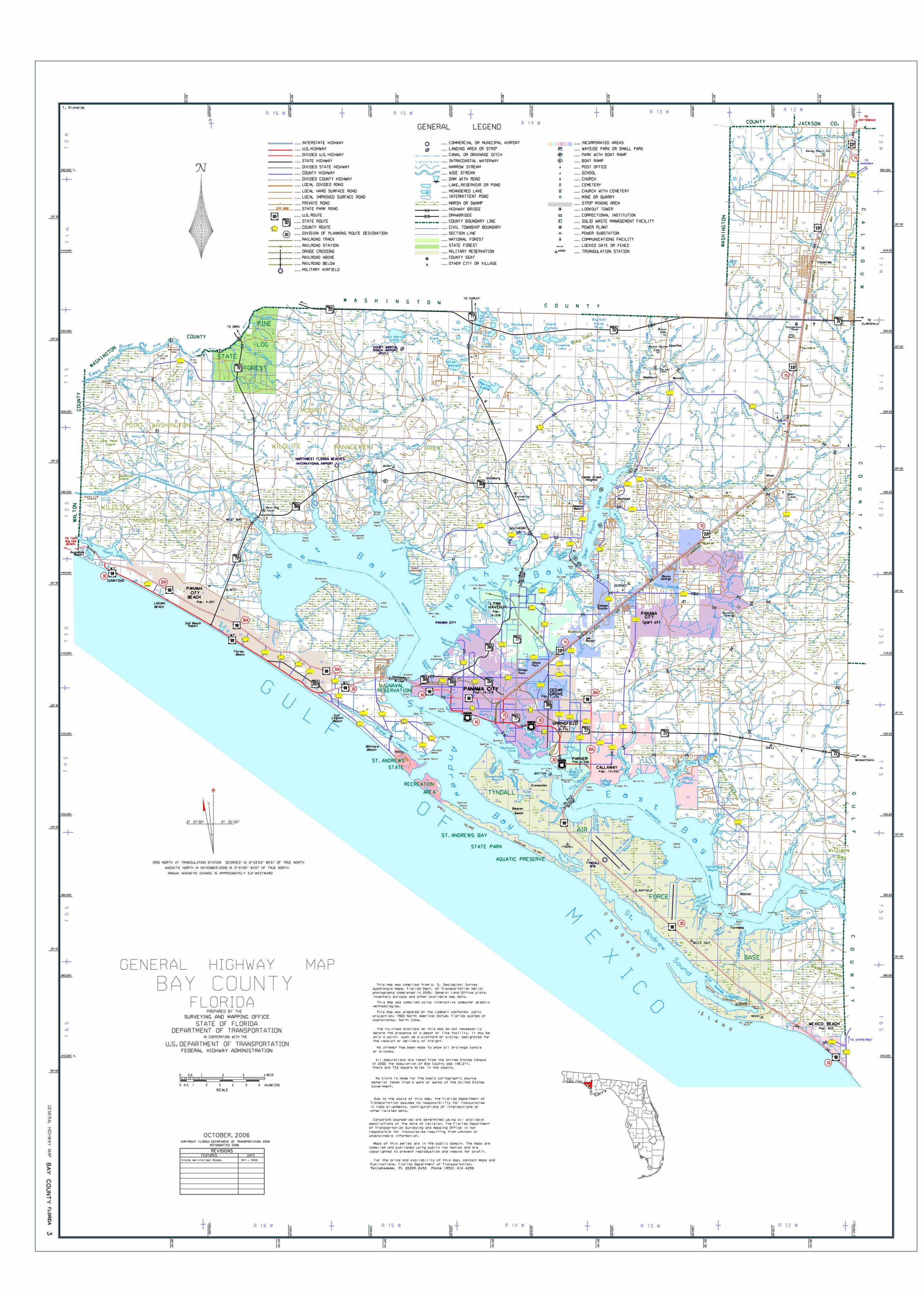
All populations are taken from the United States Census
In 2000 the population of Bay County was 148,217.
There are 753 square miles in the county.
GENERAL
COPYRIGHT FLORIDA DEPARTMENT OF TRANSPORTATION 2006
BA
Y
CO
UN
TY
STATE
FOREST
LOG
PINE
MOORE’S
PASTUREWASHINGTONPOINT
WILDLIFE MANAGEMENT AREA
WILDLIFE
MANAGEMENT
AREA
East
River
MARIANNA
TO
TO
CLARKSVILLE
Saunders
Sandy Mount Ch.
TowerYoungstown
Couch
Youngstown
PowellResort
TO FORT
WALTON
BEACH
SUNNYSIDE
LAGUNA
BEACH
Gulf Beach
Resort
Gulf
Beach
Lagoon
Biltmore
Beach
Felix
Lake
L.
Martin
Calif
ornia S
wa
mp
TO OVERSTREET
Pop. 632
MEXICO BEACH
Williams
Bay
Doe Head
Swamp
MarshallSwamp
Titi
Swa
mp
TO EBRO
Court Martial
Lake
White
Western
L.
Brit
L.
TysonL.
Sunset
L.
Tank P.
Black
P.
Bream L.
Shirt
L.
Tail
IslandBig
Lake
BlueL.
Little
Rattlesnake
L.
River L.
Is.
Little
L.
Lake
Merial
WEST BAY
Kelly P.
MillBayou
LYNNHAVEN
Pop.
6,239
Cedar
Hammock
PANAMA CITYPop. 34,378
SHELL
ISLAND
HURRICANE
ISLAND
C
R
O
O
K E
D
I S L A N D
Allanton
TO
WEWAHITCHKA
ResotaBeach
Bayhead
College
Station
P.Bear
Mashburn Bennett
Econfina
Bayou
George
FOUNTAIN
Nixon
MajetteTower
TO CHIPLEY
Island
Pond
Bay Gall
Ponds
Bay
Gall
Railroad P.
Wolf Pond
Fivemile
Lake
Vicksburg
Vicksburg
Tower
SOUTHPORT
Dirego
Park
Hiland
Park
Pop.
Pop. 1,479
Pop. 12,253
SPRINGFIELD
CEDAR
Beacon
Beach
CALLAWAY
BearSwamp
TO
COTTONDALE
AT
LA
NT
A
1,5
60,0
00 ft.
1,5
80,0
00
1,5
60,0
00 ft.
85°
50’
85
°4
5’
85
°4
0’
85
°3
5’
85
°3
0’
85
°2
5’
85
°5
0’
85°
55’
85
°55’
340,000 ft.
360,000
380,000
400,000
420,000
440,000
460,000
480,000
500,000
340,000 ft.
360,000
380,000
400,000
420,000
440,000
460,000
480,000
500,000
520,000
540,000
560,000 ft.
30°00’
30°05’
30°10’
30°15’
29°55’
30°05’
30°10’
30°15’
30°20’
30°25’
30°00’
30°20’
30°25’
30°30’
520,000
540,000
30°30’
560,000 ft.
85
°2
5’
1,7
20,0
00
1,7
00,0
00
1,6
80,0
00 ft.
85
°3
0’
85
°3
5’
1,6
60,0
00
1,6
40,0
00
1,6
20,0
00
85
°4
0’
85
°4
5’
1,6
00,0
00
T
6
ST
5
ST
4
ST
3
ST
2
ST
1
ST
2
N
R 16 W
R 16 W
R 15 W
R 15 W
R 14 W
R 14 W
R 13 W
R 13 W
R 12 W
R 12 W
T
6
ST
5
ST
4
ST
3
ST
2
ST
1
ST
1
NT
2
N
T
1
N
3
WAS
HI
NGT
ON
UN
TY
W A S H I N G T O NC O U N T Y
WA
SHI
NG
TO
N
COUNTY JACKSON CO.
CA
LH
OU
NC
OU
NT
Y
GU
LF
CO
ANNUAL MAGNETIC CHANGE IS APPROXIMATELY 5.0’ WESTWARD
GROVE
GRID NORTH AT TRIANGULATION STATION GEORGES" IS 0°32’02" WEST OF TRUE NORTH
Cromanton
LEGEND
MAGNETIC NORTH IN NOVEMBER,2006 IS 2°51’00" WEST OF TRUE NORTH
..AB.SA
RY.
ATL
ANT
A
AN
D
Brannonville
A.S.A.B. R
Y.
ST.A
NDRE
WS
BA
Y
RAIL
WA
Y
Cairo
Majette
YW
AR
AIL
BA
Y
ST.
AN
DR
EW
S
AN
D
West Bay
Tower
Brown
Cem.
Watts Gainer
Cem.
PorterCem.
Bear
Ch.
Creek
ST. ANDREWS
STATE
RECREATION
AREA
ST. ANDREWS BAY
STATE PARK
AQUATIC PRESERVE
WEST
PARK
RAFFIELD
BELLE ISLE
TYNDALL
SHELL
SOUND
NEWS
BURNT
GEORGES
TYNDALL
AIR
FORCE
BASE
1,5
80,0
00
1,6
00,0
00
1,6
20,0
00
1,6
40,0
00
1,6
60,0
00
1,6
80,0
00
1,7
00,0
00
TYNDALL
AFB
RANCH AIRPORT
(PVT.)
COURT MARTIAL
PANAMA CITY
INTERNATIONAL AIRPORT
Camp Fo
Rd.lwers
Scotts Ferry
Road
SPR
COUNTY
TALLAHASSEE BASE LINE
Oct., 2006
OCTOBER, 2006
Eagle
Nest
Bayou
Horseshoe Bayo
u
Br.
Pine
Log
Parker
Br.
Cr.
Boggy
Cushion
Cr.
lO
vesri
Cr.
Sandy
Little
Sandy
Cr.
Cr.
Mule
Creek
Cr.
Sandy
aSlt
Cr.
Tiller
Br.
Br.
BroomstrawBay
Cr.
West
Otter
Se
well
Br.
Tenmile
Br.
Creek
Three
mile
Br.
Cree
k
Ditch Branch
Crooked
Cr.
Little
Miller
Br.
Br.
Lily B
ay
Bear Bay
Mill
Burnt
Noah
Br.
Clear
water
Br.
Creek
Burnt
Mill
Cr.
Bu
trn
Mill
Cree
k
Morrell
Br.
Bell
Big
Pigeon
Creek
Ward Cr.
Cr.
Reedy
Cr.
La
wton
Br.
Calla
way
Cre
ek
Mill
Bayou
Minge
Br.
DryBr.
Blue
Br. Bayou George
Cr.
Big
Br.
Island
Cree
k
Sweetwater
Creek
Br.
Goshu
mBr.
Cr.
Juniper
South
Fork
Bear
Creek
BearCr
eek
Cedar
Creek
Econfina
Cr.
Econfina
Creek
Old
Mill
Branch
Long
Br.
Long
Branch
Cr.
Little Mocc
asinCreek
Moccasin
Cree
k
Ellis
Br.
Little
Bear
Cr.
Bear
Creek
Reedy
Creek
Creek
Bear
Double
Br.
Creek
Buckhead
Br.
Bear
Little
Juniper
Creek
Bear
Cree
k
Clear
Cr.
Slough
Bird
Rd.
Branch
Br.
Br.
Grape
Swamp Br.
ayou
B
Ha
mm
ock
Br.
Water
Br.
Geor
ge
Dave
Br.
Cr.
BAY COUNTY
CO
UN
TY
WA
LT
ON
1,7
20,0
00 ft.
Beef
wo
od
FLORIDAPREPARED BY THE
SURVEYING AND MAPPING OFFICE
DEPARTMENT OF TRANSPORTATIONIN COOPERATION WITH THE
U.S. DEPARTMENT OF TRANSPORTATION
FEDERAL HIGHWAY ADMINISTRATION
0
0.5
1 2 3 4
SCALE
MILES
0 1
0.5
2 3 4 5 6 KILOMETERS
GENERAL HIGHWAY MAP
STATE OF FLORIDA
FEATURES DATE
State Maintained Roads
REVISIONS
This map was compiled using interactive computer graphic
methodologies.
This map was prepared on the Lambert conformal conic
projection, 1983 North American Datum, Florida system of
coordinates, North Zone.
The railroad stations on this map do not necessarily
denote the presence of a depot or like facility. It may be
only a point, such as a platform or siding, designated for
the receipt or delivery of freight.
No attempt has been made to show all drainage canals
or ditches.
No claim is made for the basic cartographic source
material taken from a work or works of the United States
Government.
Maps of this series are in the public domain. The maps are
compiled and published using public tax monies and are
copyrighted to prevent reproduction and resale for profit.
For the price and availability of this map, contact Maps and
Publications, Florida Department of Transportation,
Due to the scale of this map, the Florida Department of
Transportation assumes no responsibility for inaccuracies
in road alignments, configurations of intersections or
other related data.
Corporate boundaries are determined using all available
descriptions at the date of revision. The Florida Department
of Transportation Surveying and Mapping Office is not
responsible for inaccuracies resulting from unknown or
unobtainable information.
PRIVATE ROADP
LOCAL IMPROVED SURFACE ROAD
LOCAL HARD SURFACE ROAD
LOCAL DIVIDED ROAD
DIVIDED COUNTY HIGHWAY
COUNTY HIGHWAY
DIVIDED STATE HIGHWAY
STATE HIGHWAY
DIVIDED U.S. HIGHWAY
U.S. HIGHWAY
INTERSTATE HIGHWAY
U.S. ROUTE00
STATE ROUTE00
COUNTY ROUTE00
00 DIVISION OF PLANNING ROUTE DESIGNATION
RAILROAD TRACK
RAILROAD STATION
GRADE CROSSING
RAILROAD ABOVE
RAILROAD BELOW
MILITARY AIRFIELD
COMMERCIAL OR MUNICIPAL AIRPORT
LANDING AREA OR STRIP
CANAL OR DRAINAGE DITCH
INTRACOASTAL WATERWAY
NARROW STREAM
WIDE STREAM
DAM WITH ROAD
MEANDERED LAKE
LAKE, RESERVOIR OR POND
MARSH OR SWAMP
HIGHWAY BRIDGE
DRAWBRIDGE
COUNTY BOUNDARY LINE
CIVIL TOWNSHIP BOUNDARY
SECTION LINE
NATIONAL FOREST
STATE FOREST
MILITARY RESERVATION
COUNTY SEAT
OTHER CITY OR VILLAGE
WAYSIDE PARK OR SMALL PARKWP
PARK WITH BOAT RAMPWP
BOAT RAMPB
POST OFFICE
SCHOOL
CHURCH
CEMETERY
CHURCH WITH CEMETERY
MINE OR QUARRY
STRIP MINING AREA
LOOKOUT TOWER
CORRECTIONAL INSTITUTION
SOLID WASTE MANAGEMENT FACILITYF
POWER PLANT
POWER SUBSTATION
COMMUNICATIONS FACILITY
LOCKED GATE OR FENCE
TRIANGULATION STATIONWOOD
2301
231
20
3037
386
386A
231
231
388
2301
388
2303
2303
2301
2302
2300
23022321
2321
2311
2293
2315
2321
390A
2341
2312
2314
2337
2316
23292327
2325
2322
2315
2323
3026
2297
2222
22
98
ALT
98
98
98
ALT
98 30P
30C
3035
30H
30B
3033
3030
30B
3031
392747
396
396A
B
B
B
B
B
B
B
2296
20
77
Kelly
Crooked
79
Haven
Ba
you
390
98
ALT
98
392A
79
390
389
N o
r t
h
77
36839130A
385
327
98
BUSINESS
98
98
28
98
389
28
22
98
WP
Econfi
n
a
Bra
nni
ng
2293
Horseford
F
F
231
20
GE
NE
RA
L
HIG
HW
AY
MA
P
SPR 000 STATE PARK ROAD
Lathrop
75
30
30A
30
30A
30A
30
30
30
75
75
30
75
75
30
30A
30A
2327
77
231
98
BUSINESS
98
INTRACOASTAL
WATERWAY
INTRACOASTAL
WATE
RW
AY
INTR
AC
OAST
AL
WA
TE
RW
AY
Lake
Gra
nd
Lagoon
Ad
ne
rw
Ba
y
tS
Andre
w
St.
Sound
Wild
Lagoon
Goose
aE st
B
a
y
W
e
st
Ba
yB a
y
Point
Deer
Lake
Inlet
Philip
s
Smack
Bayou
BayouSheephead
ou
ya
B re
F
sh
wat
er
Pearl Bayou
BayouPratt
Pitts
Bayo
u
Emmons
Bayou
Calla
way
Bayou
Watson
Bayou
Lake
Van
Vac
BunkersCove
ciP
al ene
Bayou
l
Cooks
Bayou
Strange
you
Baker
Bayo
u
Ba
Far
mdale
Ba
yo
u
Bayou
Little Cedar
Bayou
Fred
Bayou
Doyle
Bayou
Botheratio
n
Bayou
Harrison
Bayou
Bayou
Warren
Bayou
Alligator
Bayou
Mud
Upper Goose
Bayo
u
Ne
wman
Bayou
Fannin Bayou
John
son
Bayo
u Lynn
GooseBayou
RobinsonBayou
Anders
on
Bayo
u
Bayou
Gain
er
Bayo
uHo
dges
Williams
Bayou
Mill B
ayouB
eatty
Bayou
Posten
Bayou
Bayou
Johnson
u
a
B
yo
eo
ge
G
r
Allig
atorBl
ind
Bayo
u
Richard
Bayou
California
Bayou
Laird
Bayou
Walker
Bayo
u
Little Oyster
Bar Pt.
West Bay
Pt.
Haven
Pt.
Mill
Pt.
Shell Point
Point
Long
Anchorage
Point
Sulphur
Pt.
Dyers
Pt.
Point
Goose
Point
CoonPoint
DoylePoint
Walsonham
Point
Cedar
Point
Graze
Breakfast
Point
County Line
Landing
Laird
Camp
Barrett
Camp
Pine Log
Camp
Nobleknob
Log
Pine
Pt.
College
Pt.
Deer
Bear Pt.
Magnolia
Beach
Courtney
Pt.
Delwood
Beach
Buena Vista
Point
Alligator Point
Pt.
Davis
Pt.
Redfish
Bunkers
Pt.
Town
Point
Palmetto
Pt.
Military
Pt.
Ferry
Pt.Donalson
Point
Long
Point
Wilson Pt.
Smith Pt.
Spanish
Shanty
Pt.
Cedar
Pt.
Pt.
Piney
Goose
Point
Little Oyster
Bar Pt.
Davis
Pt.
Strange
Pt.
Murray
Point
Baker
Pt.
Lathrop
Pt.
Bull
Point
Laird Pt.
RAFFIEL
D
PENNINSULA
Davis
Beach
St. Andrew
Point
High
Pt.
McAllaster
Landing
Camp
Flowers
PITTS ISLAND
390
PANAMA
CITY
BEACH
Pop. 4,051
NorthB
ay
Bridge
PANAMACITY
(part of)
Cedar CreekHeights
INTERMITTENT POND
INCORPORATED AREAS
This map was compiled from U. S. Geological Survey
quadrangle maps, Florida Dept. of Transportation aerial
inventory surveys and other available map data.
photography completed in 2005, General Land Office plats,
REFORMATTED 2006
G U L F
O F
M E
X I C
O
Avondale
FL
ORID
A
23
4
5
31
32
11
10
3
13
26
25
34
35
368
T. Richards
Brid
ge
Du Pont
BUSINESS
98
30
RESERVATION
U.S.NAVAL
Bridge
Hathaway
Farmdale
BRITTON
Florida
Beach
0° 32’ 02"2° 51’ 00"
PARKER4,598Pop.
8,715
388
388
NORTHWEST FLORIDA BEACHES


![TR1116 copy[1] copy › resourcefiles › ... · 2 Faena Hotel Miami Beach 93.90 3 1 Hotel South Beach 90 .40 4 The Biltmore Hotel Miami– Coral Gables 90.00 5 Washington Park Hotel](https://img.pdfslide.us/doc/110x75/5f167cfcbb71a129b34bb92b/tr1116-copy1-copy-a-resourcefiles-a-2-faena-hotel-miami-beach-9390.jpg)