Embed Size (px)
Citation preview

5/20/2014 6/5/2014 Page 1 of 21 C:\Users\JimMagee\SkyDrive\Engineering\Stormwater\WO6543IvyLnTPM\2014June\WO6543Hydro.docx
HYDROLOGY REPORT Tentative Parcel Map 21208
Ivy Lane (APN 578-050-19-00)
Spring Valley, CA 919
PREPARED BY:
Jim Magee
2718 Powhatan Avenue
San Diego CA 92117
PHONE: (619) 894-1057
FOR: Panwebster Investments, Inc.
Jonathan Webster, President
2445 Brant Street #511
San Diego, CA 92101
(310) 871-6806
WO 6543
2718 Powhatan Avenue Jim Magee Phone (619) 894-1057
San Diego, CA 92117 Civil Engineering [email protected]
WO 6543 Hydrology Report TPM APN 578-050-19-00 Mr. Jonathan Webster Ivy Lane Spring Valley, CA
5/20/2014 6/5/2014 Page 2 of 21 C:\Users\JimMagee\SkyDrive\Engineering\Stormwater\WO6543IvyLnTPM\2014June\WO6543Hydro.docx
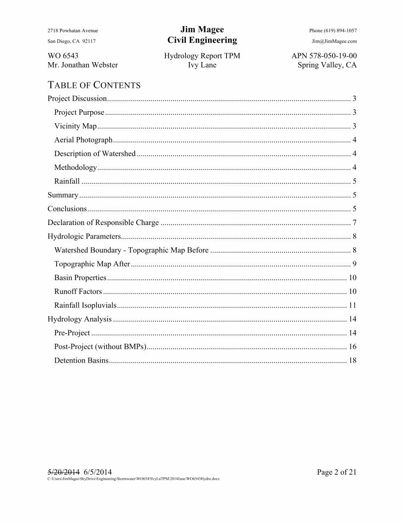
TABLE OF CONTENTS Project Discussion ........................................................................................................................... 3
Project Purpose ............................................................................................................................ 3
Vicinity Map ................................................................................................................................ 3
Aerial Photograph ........................................................................................................................ 4
Description of Watershed ............................................................................................................ 4
Methodology ................................................................................................................................ 4
Rainfall ........................................................................................................................................ 5
Summary ......................................................................................................................................... 5
Conclusions ..................................................................................................................................... 5
Declaration of Responsible Charge ................................................................................................ 7
Hydrologic Parameters .................................................................................................................... 8
Watershed Boundary - Topographic Map Before ....................................................................... 8
Topographic Map After ............................................................................................................... 9
Basin Properties ......................................................................................................................... 10
Runoff Factors ........................................................................................................................... 10
Rainfall Isopluvials .................................................................................................................... 11
Hydrology Analysis ...................................................................................................................... 14
Pre-Project ................................................................................................................................. 14
Post-Project (without BMPs) ..................................................................................................... 16
Detention Basins ........................................................................................................................ 18
2718 Powhatan Avenue Jim Magee Phone (619) 894-1057
San Diego, CA 92117 Civil Engineering [email protected]
WO 6543 Hydrology Report TPM APN 578-050-19-00 Mr. Jonathan Webster Ivy Lane Spring Valley, CA
5/20/2014 6/5/2014 Page 3 of 21 C:\Users\JimMagee\SkyDrive\Engineering\Stormwater\WO6543IvyLnTPM\2014June\WO6543Hydro.docx
PROJECT DISCUSSION
PROJECT PURPOSE
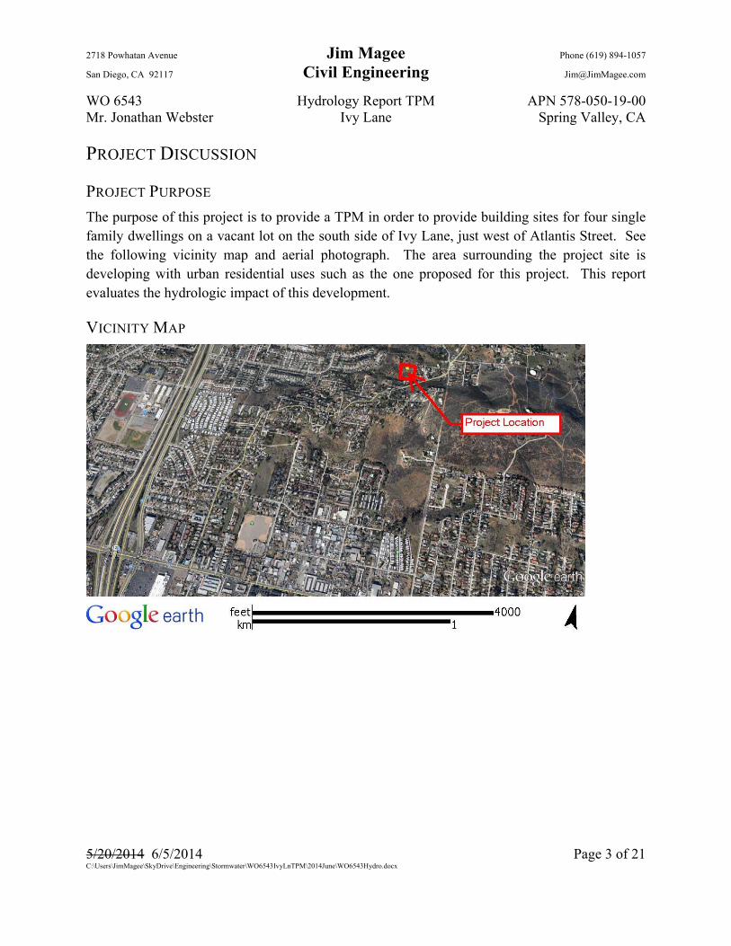
The purpose of this project is to provide a TPM in order to provide building sites for four single family dwellings on a vacant lot on the south side of Ivy Lane, just west of Atlantis Street. See the following vicinity map and aerial photograph. The area surrounding the project site is developing with urban residential uses such as the one proposed for this project. This report evaluates the hydrologic impact of this development.
VICINITY MAP

2718 Powhatan Avenue Jim Magee Phone (619) 894-1057
San Diego, CA 92117 Civil Engineering [email protected]
WO 6543 Hydrology Report TPM APN 578-050-19-00 Mr. Jonathan Webster Ivy Lane Spring Valley, CA
5/20/2014 6/5/2014 Page 4 of 21 C:\Users\JimMagee\SkyDrive\Engineering\Stormwater\WO6543IvyLnTPM\2014June\WO6543Hydro.docx
AERIAL PHOTOGRAPH
DESCRIPTION OF WATERSHED
As can be seen from the above photos and the Drainage Basins map on page 8, the project sets along the crest of a hill. Therefore, the drainage basins of this project consist almost entirely of the project property only. As a consequence, the basins and the flows are very small. The project site sets near the top of a small hill and consists of barren ground flowing to the west and north. This flow pattern will be maintained.
METHODOLOGY
The hydrology analysis for this project was conducted in accordance with the San Diego County Hydrology Manual dated June 2003. Because of the size of the drainage basins involved, the Rational Method was used as specified on page 3-1 of the Hydrology Manual. There are no junctions of independent basins as described in Section 3.4 of the Hydrology Manual. Therefore, it was not necessary to use the Modified Rational Method to combine flows.

2718 Powhatan Avenue Jim Magee Phone (619) 894-1057
San Diego, CA 92117 Civil Engineering [email protected]
WO 6543 Hydrology Report TPM APN 578-050-19-00 Mr. Jonathan Webster Ivy Lane Spring Valley, CA
5/20/2014 6/5/2014 Page 5 of 21 C:\Users\JimMagee\SkyDrive\Engineering\Stormwater\WO6543IvyLnTPM\2014June\WO6543Hydro.docx
All hydraulic analysis was conducted in accordance with standard engineering practice. The references used for these analyses include King’s Handbook of Hydraulics, nomographs from the San Diego County Drainage Design Manual, the Bureau of Public Roads, the City of San Diego and other commonly accepted sources.
RAINFALL
The rainfall amounts for this analysis are presented on page 11. They were taken from the isopluvial maps in the San Diego County Hydrology Manual.
SUMMARY The following table summarizes the results of this analysis. See the Hydrology Calculations section of this report for the detailed calculations of each event. It should be noted that the flows shown for the project are very small flows. This is a result of the project property being at the top of a small hill.
CONCLUSIONS This project will not have an impact on the drainage flows of this property. The project is designed to maintain surface discharge quantities from the project onto adjacent properties.
The RWQCB and the County of San Diego have adopted regulations requiring projects which substantially increase flood flows to adopt Hydromodification mitigating measures. The project’s Hydro Modification Plan is shown in the project Storm Water Management Plan as appendix D. That essentially consists of the construction of flow-through planters to provide water quality control and volume control. These are shown on the project grading plans. Because of this, the flows after are the same as the flows before.
Because of the project design, there will not be any changes that will result in substantial erosion or siltation on- or off-site. For the same reasons discussed above, the project will be not substantially increase the rate or amount of surface runoff in a manner which would result in flooding on- or off-site. For the same reasons discussed in the above, the proposed project will not create or contribute additional runoff water which will exceed the capacity of existing or planned storm water drainage systems.
Conc. Pt. Description Existing Flow Existing Area Existing C value Proposed Flow Proposed Area Proposed C value Mitigationc.f.s. (100-yr) acres c.f.s. (100-yr) acres
1 Basin A 3.22 1.55 0.35 4.68 1.55 0.46 Flow-Through Planter2 Basin B 1.69 0.85 0.35 2.41 0.85 0.46 Flow-Through Planter
Summary Table
2718 Powhatan Avenue Jim Magee Phone (619) 894-1057
San Diego, CA 92117 Civil Engineering [email protected]
WO 6543 Hydrology Report TPM APN 578-050-19-00 Mr. Jonathan Webster Ivy Lane Spring Valley, CA
5/20/2014 6/5/2014 Page 6 of 21 C:\Users\JimMagee\SkyDrive\Engineering\Stormwater\WO6543IvyLnTPM\2014June\WO6543Hydro.docx
The housing pads for this project set above and clear of any drainage flows. The areas within the project is not mapped on a federal Flood Hazard Boundary or Flood Insurance Flood Map or other flood hazard delineation map including County Floodplain Maps are shown on the project plans.
2718 Powhatan Avenue Jim Magee Phone (619) 894-1057
San Diego, CA 92117 Civil Engineering [email protected]
WO 6543 Hydrology Report TPM APN 578-050-19-00 Mr. Jonathan Webster Ivy Lane Spring Valley, CA
5/20/2014 6/5/2014 Page 7 of 21 C:\Users\JimMagee\SkyDrive\Engineering\Stormwater\WO6543IvyLnTPM\2014June\WO6543Hydro.docx
HYDROLOGY REPORT
OWNER: Panwebster Investments, Inc. Jonathan Webster, President 2445 Brant Street #511
San Diego, CA 92101 (310) 871-6806
DECLARATION OF RESPONSIBLE CHARGE
I hereby declare that I am the engineer of work for this project, that I have exercised responsible charge over the design of the project as defined in section 6703 of the Business and Professions Code, and that the design is consistent with current standards.
I understand the check of the project drawings and specifications by the County of San Diego is confined to review only and does not relieve me, as engineer of work, of responsibilities for project design.
Jim Magee 2718 Powhatan Avenue San Diego, CA 92117
___________________________________ 5/20/2014 6/5/2014 .
Jim Magee R.C.E. 21058 Date
My registration expires 9-30-2015

2718 Powhatan Avenue Jim Magee Phone (619) 894-1057
San Diego, CA 92117 Civil Engineering [email protected]
WO 6543 Hydrology Report TPM APN 578-050-19-00 Mr. Jonathan Webster Ivy Lane Spring Valley, CA
5/20/2014 6/5/2014 Page 8 of 21 C:\Users\JimMagee\SkyDrive\Engineering\Stormwater\WO6543IvyLnTPM\2014June\WO6543Hydro.docx
HYDROLOGIC PARAMETERS
WATERSHED BOUNDARY - TOPOGRAPHIC MAP BEFORE
2718 Powhatan Avenue Jim Magee Phone (619) 894-1057
San Diego, CA 92117 Civil Engineering [email protected]
WO 6543 Hydrology Report TPM APN 578-050-19-00 Mr. Jonathan Webster Ivy Lane Spring Valley, CA
5/20/2014 6/5/2014 Page 9 of 21 C:\Users\JimMagee\SkyDrive\Engineering\Stormwater\WO6543IvyLnTPM\2014June\WO6543Hydro.docx
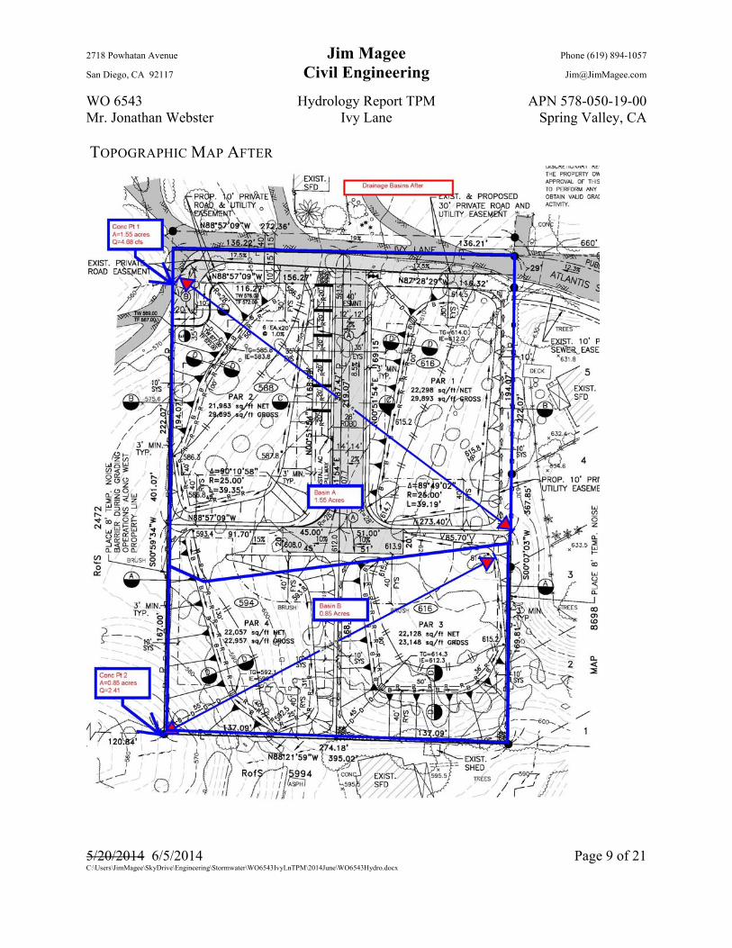
TOPOGRAPHIC MAP AFTER

2718 Powhatan Avenue Jim Magee Phone (619) 894-1057
San Diego, CA 92117 Civil Engineering [email protected]
WO 6543 Hydrology Report TPM APN 578-050-19-00 Mr. Jonathan Webster Ivy Lane Spring Valley, CA
5/20/2014 6/5/2014 Page 10 of 21 C:\Users\JimMagee\SkyDrive\Engineering\Stormwater\WO6543IvyLnTPM\2014June\WO6543Hydro.docx
The above maps are from the project plans and are at the scale shown. They show the watershed boundaries and the concentration points used in this analysis. They are NOT shown at a particular scale so that it would fit within this report. The following table summarizes the hydrologic factors of the basins.
Drainage Basin A flows toward the northwest corner of the property. After project construction it will discharge at the same location. Drainage Basin B currently flows toward the southwest corner of the property. This will be the same drainage pattern after the project.
BASIN PROPERTIES
RUNOFF FACTORS
The following table is from the County of San Diego Hydrology Manual and provides runoff factors “C” based on soil type and land use.
Concentration Point # Basin # Area (acres) Hi pt Low pt Ti elev Elev change Basin Length Basin slope (%)
1 A 1.55 626.0 556.0 616.0 70.0 334 21.0%
2 B 0.85 626.0 560.0 618.0 66.0 300 22.0%
Basin Properties
Table 3-1 Soil TypeIndex Land Use A B C D
1 Natural 0.20 0.25 0.30 0.352 LDR 1.0 DU/A or less 0.27 0.32 0.36 0.413 LDR 2.0 DU/A or less 0.34 0.38 0.42 0.464 LDR 2.9 DU/A or less 0.38 0.41 0.45 0.495 MDR 4.3 DU/A or less 0.41 0.45 0.48 0.526 MDR 7.3 DU/A or less 0.48 0.51 0.54 0.577 MDR 10.9 DU/A or less 0.52 0.54 0.57 0.608 MDR 14.5 DU/A or less 0.55 0.58 0.60 0.639 HDR 24.0 DU/A or less 0.66 0.67 0.69 0.7110 HDR 43.0 DU/A or less 0.76 0.77 0.78 0.7911 Neighborhood Commercial 0.76 0.77 0.78 0.7912 General Commercial 0.80 0.80 0.81 0.8213 Office Professional/Commercial 0.83 0.84 0.84 0.8514 Commercial/Industrial Limited 0.83 0.84 0.84 0.8515 Commercial/Industrial General 0.87 0.87 0.87 0.8716 RDR 0.125 DU/A or less 0.22 0.27 0.32 0.3717 RDR 0.25 DU/A or less 0.25 0.30 0.34 0.3918 RDR 0.50 DU/A or less 0.26 0.31 0.35 0.40

2718 Powhatan Avenue Jim Magee Phone (619) 894-1057
San Diego, CA 92117 Civil Engineering [email protected]
WO 6543 Hydrology Report TPM APN 578-050-19-00 Mr. Jonathan Webster Ivy Lane Spring Valley, CA
5/20/2014 6/5/2014 Page 11 of 21 C:\Users\JimMagee\SkyDrive\Engineering\Stormwater\WO6543IvyLnTPM\2014June\WO6543Hydro.docx
Soil Hydrologic Groups
The following map of Soil Groups is from the San Diego County Hydrology Manual. As can be seen, the soil group for the drainage basins of this project is Soil Group “D”. This type of soil results in the most runoff during storms because of its inability to absorb the rainwater. This fact is reflected in the above Runoff Factor “C”. Those “C” values were used in the analysis of the basins as shown later in this report.
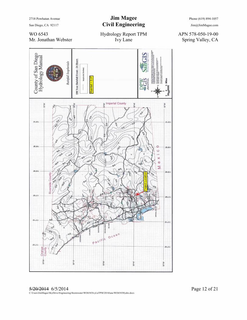
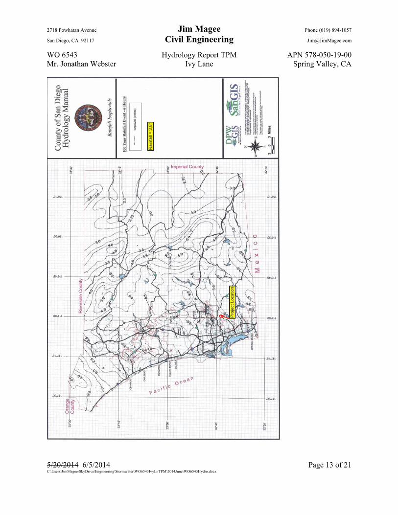
RAINFALL ISOPLUVIALS
The following rainfall amounts are from the isopluvial maps in the San Diego County Hydrology Manual. For the analysis of small basins the Rational Method uses the 100-year 6-hour event as the controlling event and that is used for this analysis. The 6-hour event (2.8”) is between 0.45 and 0.65 of the 24-hour event (6.0”) for all return intervals and therefore did not need to be adjusted as described in the Hydrology Manual.
2718 Powhatan Avenue Jim Magee Phone (619) 894-1057
San Diego, CA 92117 Civil Engineering [email protected]
WO 6543 Hydrology Report TPM APN 578-050-19-00 Mr. Jonathan Webster Ivy Lane Spring Valley, CA
5/20/2014 6/5/2014 Page 12 of 21 C:\Users\JimMagee\SkyDrive\Engineering\Stormwater\WO6543IvyLnTPM\2014June\WO6543Hydro.docx
2718 Powhatan Avenue Jim Magee Phone (619) 894-1057
San Diego, CA 92117 Civil Engineering [email protected]
WO 6543 Hydrology Report TPM APN 578-050-19-00 Mr. Jonathan Webster Ivy Lane Spring Valley, CA
5/20/2014 6/5/2014 Page 13 of 21 C:\Users\JimMagee\SkyDrive\Engineering\Stormwater\WO6543IvyLnTPM\2014June\WO6543Hydro.docx
2718 Powhatan Avenue Jim Magee Phone (619) 894-1057
San Diego, CA 92117 Civil Engineering [email protected]
WO 6543 Hydrology Report TPM APN 578-050-19-00 Mr. Jonathan Webster Ivy Lane Spring Valley, CA
5/20/2014 6/5/2014 Page 14 of 21 C:\Users\JimMagee\SkyDrive\Engineering\Stormwater\WO6543IvyLnTPM\2014June\WO6543Hydro.docx
HYDROLOGY ANALYSIS
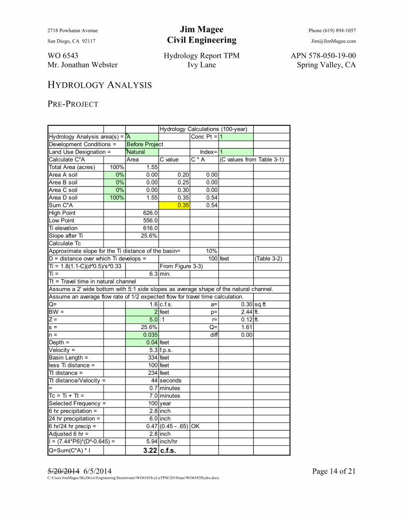
PRE-PROJECT
Hydrology Calculations (100-year)Hydrology Analysis area(s) = A Conc Pt = 1Development Conditions = Before ProjectLand Use Designation = Natural Index= 1Calculate C*A Area C value C * A (C values from Table 3-1)Total Area (acres) 100% 1.55Area A soil 0% 0.00 0.20 0.00Area B soil 0% 0.00 0.25 0.00Area C soil 0% 0.00 0.30 0.00Area D soil 100% 1.55 0.35 0.54Sum C*A 0.35 0.54High Point 626.0Low Point 556.0Ti elevation 616.0Slope after Ti 25.6%Calculate TcApproximate slope for the Ti distance of the basin= 10%D = distance over which Ti develops = 100 feet (Table 3-2)Ti = 1.8(1.1-C)(d^0.5)/s^0.33 From Figure 3-3)Ti = 6.3 min.Tt = Travel time in natural channelAssume a 2' wide bottom with 5:1 side slopes as average shape of the natural channel.Assume an average flow rate of 1/2 expected flow for travel time calculation.Q= 1.6 c.f.s. a= 0.30 sq.ftBW = 2 feet p= 2.44 ft.Z = 5.0 :1 r= 0.12 ft.s = 25.6% Q= 1.61n = 0.035 diff 0.00Depth = 0.04 feetVelocity = 5.3 f.p.s.Basin Length = 334 feetless Ti distance = 100 feetTt distance = 234 feetTt distance/Velocity = 44 seconds= 0.7 minutesTc = Ti + Tt = 7.0 minutesSelected Frequency = 100 year6 hr precipitation = 2.8 inch24 hr precipitation = 6.0 inch6 hr/24 hr precip = 0.47 (0.45 - .65) OKAdjusted 6 hr = 2.8 inchI = (7.44*P6)*(D -̂0.645) = 5.94 inch/hr
Q=Sum(C*A) * I 3.22 c.f.s.

2718 Powhatan Avenue Jim Magee Phone (619) 894-1057
San Diego, CA 92117 Civil Engineering [email protected]
WO 6543 Hydrology Report TPM APN 578-050-19-00 Mr. Jonathan Webster Ivy Lane Spring Valley, CA
5/20/2014 6/5/2014 Page 15 of 21 C:\Users\JimMagee\SkyDrive\Engineering\Stormwater\WO6543IvyLnTPM\2014June\WO6543Hydro.docx
Hydrology Calculations (100-yr)Hydrology Analysis area(s) = B Conc Pt = 2Development Conditions = Before ProjectLand Use Designation = Natural Index= 1Calculate C*A Area C value C * A (C values from Table 3-1)Total Area (acres) 100% 0.85Area A soil 0% 0.00 0.20 0.00Area B soil 0% 0.00 0.25 0.00Area C soil 0% 0.00 0.30 0.00Area D soil 100% 0.85 0.35 0.30Sum C*A 0.35 0.30High Point 626.0Low Point 560.0100' elevation 618.0Slope after 100' 29.00%Calculate TcApproximate slope for the first 100' of the basin= 8 %D = distance over which Ti develops = 100 feet (Table 3-2)Ti = 1.8(1.1-C)(d 0̂.5)/s^0.33 From Figure 3-3)Ti = 6.8 min.Tt = Travel time in natural channelAssume a 2' wide bottom with 5:1 side slopes as average shape of the ground.Assume an average flow rate of 1/2 expected flow for travel time calculation.Q= 0.8 c.f.s. a= 0.19 sq.ftBW = 2 feet p= 2.28 ft.Z = 5.0 :1 r= 0.08 ft.s = 29% Q= 0.84n = 0.035 diff 0.00Depth = 0.03 feetVelocity = 4.4 f.p.s.Basin Length = 300 feetless Ti distance = 100 feetTt surface distance = 200 feetTt distance/Velocity = 45 seconds= 0.8 minutesTc = Ti + Tt = 7.5 minutesSelected Frequency = 100 year6 hr precipitation = 2.8 inch24 hr precipitation = 6.0 inch6 hr/24 hr precip = 0.47 (0.45 - .65) OKAdjusted 6 hr = 2.8 inchI = (7.44*P6)*(D -̂0.645) = 5.67 inch/hr
Q=Sum(C*A) * I 1.69 c.f.s.

2718 Powhatan Avenue Jim Magee Phone (619) 894-1057
San Diego, CA 92117 Civil Engineering [email protected]
WO 6543 Hydrology Report TPM APN 578-050-19-00 Mr. Jonathan Webster Ivy Lane Spring Valley, CA
5/20/2014 6/5/2014 Page 16 of 21 C:\Users\JimMagee\SkyDrive\Engineering\Stormwater\WO6543IvyLnTPM\2014June\WO6543Hydro.docx
POST-PROJECT (WITHOUT BMPS)
Hydrology Calculations (100-year)Hydrology Analysis area(s) = A Conc Pt = 1.2Development Conditions = After ProjectLand Use Designation = LDR 2.0 DU/A or less Index= 3Calculate C*A Area C value C * A (C values from Table 3-1)Total Area (acres) 100% 1.55Area A soil 0% 0.00 0.34 0.00Area B soil 0% 0.00 0.38 0.00Area C soil 0% 0.00 0.42 0.00Area D soil 100% 1.55 0.46 0.71Sum C*A 0.46 0.71High Point 626Low Point 556100' elevation 616Slope after 100' 25.64%Calculate TcApproximate slope for the first 100' of the basin= 10 %D = distance over which Ti develops = 100 feet (Table 3-2)Ti = 1.8(1.1-C)(d 0̂.5)/s 0̂.33 From Figure 3-3)Ti = 5.4 min.Tt = Travel time in natural channelAssume a 2' wide bottom with 5:1 side slopes as average shape of the swale.Assume an average flow rate of 1/2 expected flow for travel time calculation.Q= 2.34 c.f.s. a= 0.38 sq.ftBW = 2 feet p= 2.56 ft.Z = 5.0 :1 r= 0.15 ft.s = 26% Q= 2.34n = 0.035 diff 0.00Depth = 0.05 feetVelocity = 6.1 f.p.s.Basin Length = 334 feetless Ti distance = 100 feetTt distance = 234 feetTt distance/Velocity = 38 seconds= 0.6 minutesTc = Ti + Tt = 6.0 minutesSelected Frequency = 100 year6 hr precipitation = 2.8 inch24 hr precipitation = 6.0 inch6 hr/24 hr precip = 0.47 (0.45 - .65) OKAdjusted 6 hr = 2.8 inchI = (7.44*P6)*(D -̂0.645) = 6.56 inch/hr
Q=Sum(C*A) * I 4.68 c.f.s.
2718 Powhatan Avenue Jim Magee Phone (619) 894-1057
San Diego, CA 92117 Civil Engineering [email protected]
WO 6543 Hydrology Report TPM APN 578-050-19-00 Mr. Jonathan Webster Ivy Lane Spring Valley, CA
5/20/2014 6/5/2014 Page 17 of 21 C:\Users\JimMagee\SkyDrive\Engineering\Stormwater\WO6543IvyLnTPM\2014June\WO6543Hydro.docx
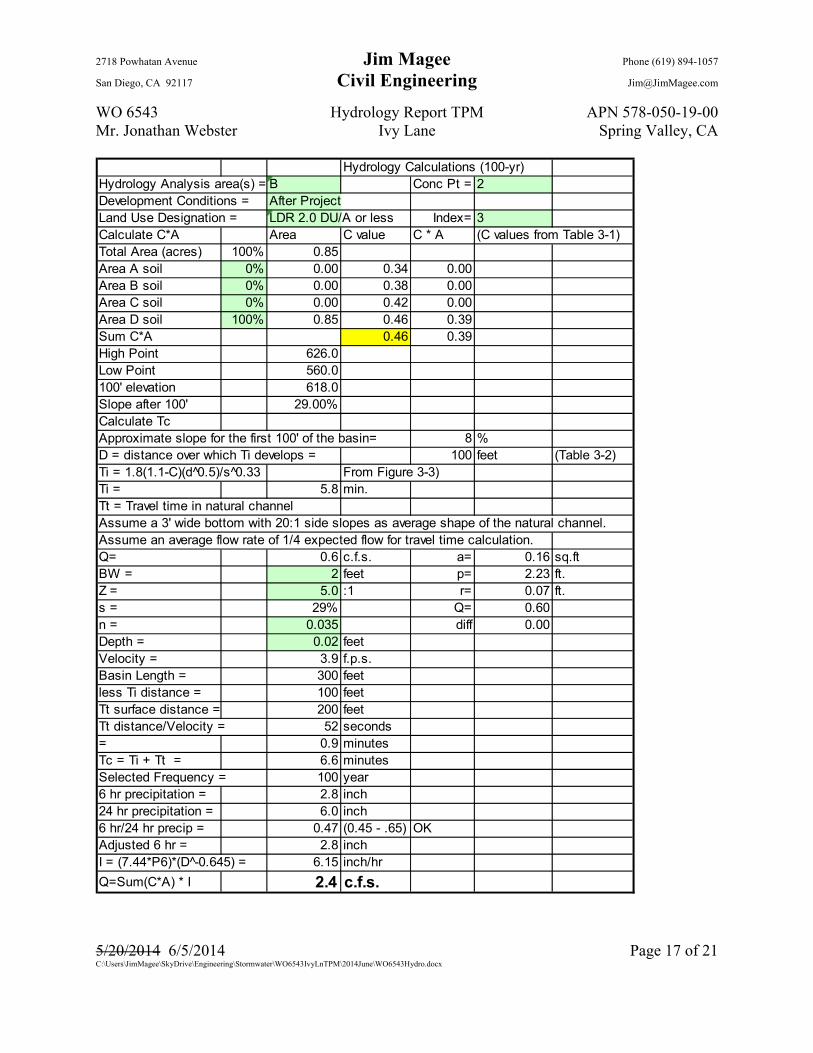
Hydrology Calculations (100-yr)Hydrology Analysis area(s) = B Conc Pt = 2Development Conditions = After ProjectLand Use Designation = LDR 2.0 DU/A or less Index= 3Calculate C*A Area C value C * A (C values from Table 3-1)Total Area (acres) 100% 0.85Area A soil 0% 0.00 0.34 0.00Area B soil 0% 0.00 0.38 0.00Area C soil 0% 0.00 0.42 0.00Area D soil 100% 0.85 0.46 0.39Sum C*A 0.46 0.39High Point 626.0Low Point 560.0100' elevation 618.0Slope after 100' 29.00%Calculate TcApproximate slope for the first 100' of the basin= 8 %D = distance over which Ti develops = 100 feet (Table 3-2)Ti = 1.8(1.1-C)(d 0̂.5)/s^0.33 From Figure 3-3)Ti = 5.8 min.Tt = Travel time in natural channelAssume a 3' wide bottom with 20:1 side slopes as average shape of the natural channel.Assume an average flow rate of 1/4 expected flow for travel time calculation.Q= 0.6 c.f.s. a= 0.16 sq.ftBW = 2 feet p= 2.23 ft.Z = 5.0 :1 r= 0.07 ft.s = 29% Q= 0.60n = 0.035 diff 0.00Depth = 0.02 feetVelocity = 3.9 f.p.s.Basin Length = 300 feetless Ti distance = 100 feetTt surface distance = 200 feetTt distance/Velocity = 52 seconds= 0.9 minutesTc = Ti + Tt = 6.6 minutesSelected Frequency = 100 year6 hr precipitation = 2.8 inch24 hr precipitation = 6.0 inch6 hr/24 hr precip = 0.47 (0.45 - .65) OKAdjusted 6 hr = 2.8 inchI = (7.44*P6)*(D -̂0.645) = 6.15 inch/hr
Q=Sum(C*A) * I 2.4 c.f.s.
2718 Powhatan Avenue Jim Magee Phone (619) 894-1057
San Diego, CA 92117 Civil Engineering [email protected]
WO 6543 Hydrology Report TPM APN 578-050-19-00 Mr. Jonathan Webster Ivy Lane Spring Valley, CA
5/20/2014 6/5/2014 Page 18 of 21 C:\Users\JimMagee\SkyDrive\Engineering\Stormwater\WO6543IvyLnTPM\2014June\WO6543Hydro.docx
DETENTION BASINS
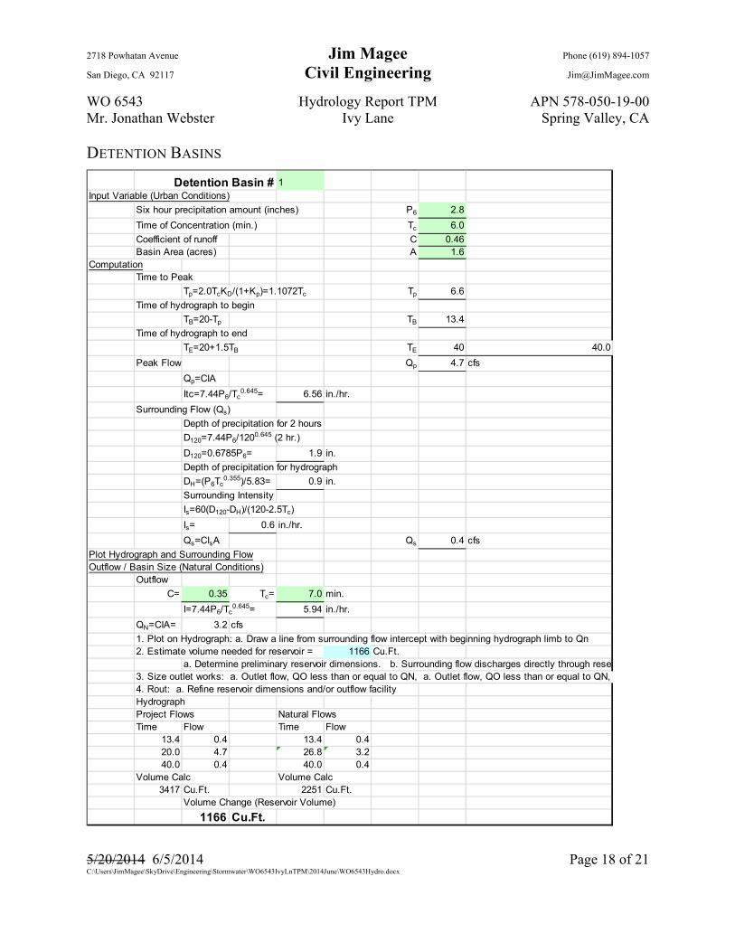
Detention Basin # 1Input Variable (Urban Conditions)
Six hour precipitation amount (inches) P6 2.8
Time of Concentration (min.) Tc 6.0
Coefficient of runoff C 0.46Basin Area (acres) A 1.6
ComputationTime to Peak
Tp=2.0TcKD/(1+Kp)=1.1072Tc Tp 6.6
Time of hydrograph to begin
TB=20-Tp TB 13.4
Time of hydrograph to end
TE=20+1.5TB TE 40 40.0
Peak Flow Qp 4.7 cfs
Qp=CIA
Itc=7.44P6/Tc0.645= 6.56 in./hr.
Surrounding Flow (Qs)
Depth of precipitation for 2 hours
D120=7.44P6/1200.645 (2 hr.)
D120=0.6785P6= 1.9 in.
Depth of precipitation for hydrograph
DH=(P6Tc0.355)/5.83= 0.9 in.
Surrounding Intensity
Is=60(D120-DH)/(120-2.5Tc)
Is= 0.6 in./hr.
Qs=CIsA Qs 0.4 cfs
Plot Hydrograph and Surrounding FlowOutflow / Basin Size (Natural Conditions)
Outflow
C= 0.35 Tc= 7.0 min.
I=7.44P6/Tc0.645= 5.94 in./hr.
QN=CIA= 3.2 cfs
1. Plot on Hydrograph: a. Draw a line from surrounding flow intercept with beginning hydrograph limb to Qn2. Estimate volume needed for reservoir = 1166 Cu.Ft.
3. Size outlet works: a. Outlet flow, QO less than or equal to QN, a. Outlet flow, QO less than or equal to QN, 4. Rout: a. Refine reservoir dimensions and/or outflow facilityHydrographProject Flows Natural FlowsTime Flow Time Flow
13.4 0.4 13.4 0.420.0 4.7 26.8 3.240.0 0.4 40.0 0.4
Volume Calc Volume Calc3417 Cu.Ft. 2251 Cu.Ft.
Volume Change (Reservoir Volume)
1166 Cu.Ft.
a. Determine preliminary reservoir dimensions. b. Surrounding flow discharges directly through reser

2718 Powhatan Avenue Jim Magee Phone (619) 894-1057
San Diego, CA 92117 Civil Engineering [email protected]
WO 6543 Hydrology Report TPM APN 578-050-19-00 Mr. Jonathan Webster Ivy Lane Spring Valley, CA
5/20/2014 6/5/2014 Page 19 of 21 C:\Users\JimMagee\SkyDrive\Engineering\Stormwater\WO6543IvyLnTPM\2014June\WO6543Hydro.docx
Detention Basin # 2Input Variable (Urban Conditions)
Six hour precipitation amount (inches) P6 2.80
Time of Concentration (min.) Tc 6.623381
Coefficient of runoff C 0.46Basin Area (acres) A 0.9
ComputationTime to Peak
Tp=2.0TcKD/(1+Kp)=1.1072Tc Tp 7.3
Time of hydrograph to begin
TB=20-Tp TB 12.7
Time of hydrograph to end
TE=20+1.5TB TE 39.0
Peak Flow Qp 2.4 cfs
Qp=CIA
Itc=7.44P6/Tc0.645= 6.15 in./hr.
Surrounding Flow (Qs)
Depth of precipitation for 2 hours
D120=7.44P6/1200.645 (2 hr.)
D120=0.6785P6= 1.9 in.
Depth of precipitation for hydrograph
DH=(P6Tc0.355)/5.83= 0.9 in.
Surrounding Intensity
Is=60(D120-DH)/(120-2.5Tc)
Is= 0.6 in./hr.
Qs=CIsA Qs 0 cfs
Plot Hydrograph and Surrounding FlowOutflow / Basin Size (Natural Conditions)
Outflow
C= 0.35 Tc= 7.0 min.
I=7.44P6/Tc0.645= 5.94 in./hr.
QN=CIA= 1.8 cfs
1. Plot on Hydrograph
2. Estimate volume needed for reservoir = 505 Cu.Ft.a. Determine preliminary reservoir dimensions
3. Size outlet works
a. Outlet flow, QO less than or equal to QN
b. Stay within the limits of the reservoir4. Rout
a. Refine reservoir dimensions and/or outflow facility
HydrographProject Flows Natural FlowsTime Flow Time Flow
12.7 0.2 12.7 0.220.0 2.4 25.6 1.839.0 0.2 39.0 0.2
Volume Calc Volume Calc1729 Cu.Ft. 1223 Cu.Ft.
Volume Change (Reservoir Volume)
505 Cu.Ft.
a. Draw line from surrounding flow intercept with beginning
hydrograph limb to QN
b. Surrounding flow discharges directly through reservoir without detaining any storage

2718 Powhatan Avenue Jim Magee Phone (619) 894-1057
San Diego, CA 92117 Civil Engineering [email protected]
WO 6543 Hydrology Report TPM APN 578-050-19-00 Mr. Jonathan Webster Ivy Lane Spring Valley, CA
5/20/2014 6/5/2014 Page 20 of 21 C:\Users\JimMagee\SkyDrive\Engineering\Stormwater\WO6543IvyLnTPM\2014June\WO6543Hydro.docx
0.0
0.5
1.0
1.5
2.0
2.5
3.0
3.5
4.0
4.5
5.0
0.0 10.0 20.0 30.0 40.0 50.0
Flo
w R
ate
(cfs
)
Time (Minutes)
Detention Basin1 Flows
Natural…Project…
0.0
0.5
1.0
1.5
2.0
2.5
3.0
0.0 10.0 20.0 30.0 40.0 50.0
Flo
w R
ate
(cfs
)
Time (Minutes)
Detention Basin2 Flows
NaturalFlows…

2718 Powhatan Avenue Jim Magee Phone (619) 894-1057
San Diego, CA 92117 Civil Engineering [email protected]
WO 6543 Hydrology Report TPM APN 578-050-19-00 Mr. Jonathan Webster Ivy Lane Spring Valley, CA
5/20/2014 6/5/2014 Page 21 of 21 C:\Users\JimMagee\SkyDrive\Engineering\Stormwater\WO6543IvyLnTPM\2014June\WO6543Hydro.docx
The above calculations and charts are based on section 6 of the San Diego County Hydrology Manual. They provide the volume needed so that the flow after the project is no more than the flow before the project for the 100-year storm. The following chart compares the volume calculated above the volume provided in the various BMPs that will be built with the project.
As you can see the East half of the Project (Basin A) will have a volume of 3,058 ft.³ compared with the required 1,166 ft.³. This represents a 260% excess volume. The West half of the Project (Basin B) will have a volume of 1,671 ft.³ compared with the required 505 ft.³. This represents a 330% excess volume.
Location L (ft) W (ft) V1 D (ft) V2 D (ft) A (sq ft) V1 (cu ft) V2 (cu ft) Detention VVegetated Swale 60 10 0.5 0 600 150 0 0Parcel 1 79 3 1 1 237 237 237 315.21Private Road 123 10 1 1 1230 1230 1230 1635.9Parcel 2 240 3 1 1 720 720 720 957.6
****East half Project**** 2787 2337 2187 3058.71
Parcel 3 189 3 1 1 567 567 567 754.11Parcel 4 230 3 1 1 690 690 690 917.7
****West half Project**** 1257 1257 1257 1671.81
Project Totals 4044 3594 3444 4730.52
Summary of BMP Quantities Provided