Embed Size (px)
Citation preview

United States
Department of
Agriculture
Forest
Service
May 2014
Hydrology Report Salmon Salvage Project Salmon/Scott River Ranger District, Klamath National Forest Siskiyou County, CA
Prepared By:
__________________________________________________________________
Original Draft by Kyle Wright, Hydrologist, Klamath National Forest, 3/14/2014 Reviewed and Updated by Verna Yin, District Hydrologist, Klamath National Forest,
3/28/2014

ii
Table of Contents EXECUTIVE SUMMARY .................................................................................................................................. 1
Hydrology Report .......................................................................................................................................... 6
Methodology ........................................................................................................................................... 7
Analysis Indicators .................................................................................................................................. 10
Spatial and Temporal Bounding of Analysis Area ................................................................................... 10
Affected Environment ............................................................................................................................. 11
Environmental Consequences ................................................................................................................ 18
Literature Cited ....................................................................................................................................... 29

iii
The U.S. Department of Agriculture (USDA) prohibits discrimination in all its programs and activities on the basis of race, color, national origin, age, disability, and where applicable, sex, marital status, familial status, parental status, religion, sexual orientation, genetic information, political beliefs, reprisal, or because all or part of an individual’s income is derived from any public assistance program. (Not all prohibited bases apply to all programs.) Persons with disabilities who require alternative means for communication of program information (Braille, large print, audiotape, etc.) should contact USDA's TARGET Center at (202) 720-2600 (voice and TDD).
To file a complaint of discrimination, write to USDA, Director, Office of Civil Rights, 1400 Independence Avenue, S.W., Washington, D.C. 20250-9410, or call (800) 795-3272 (voice) or (202) 720-6382 (TDD). USDA is an equal opportunity provider and employer.

1
EXECUTIVE SUMMARY The Salmon Salvage Project is located in the North Fork Salmon River watershed, a tributary to the Klamath River. The project proposes to salvage harvest trees, remove hazard trees, and reduce fuels through prescribed burns. The focus of this report is to depict the existing conditions of North Fork Salmon River compared to the desired conditions outlined in the Klamath National Forest’s Land and Resource Management Plan (LRMP; USFS, 2010) and Klamath National Forest North Fork Watershed Analysis (USFS 1995), and the effects of the no-action and action alternatives on sediment delivery to streams, peak and base flow, temperature, and channel condition/geomorphology. The North Fork Salmon River watershed has high concentrations of dormant and active landslide terrain with a dense road network and a long history of mining and forest management. The residual effects of these past actions, in combination with the effects of floods and wildfires, have led to a watershed whose sedimentation and stream temperature are not currently meeting desired conditions. However, recent sediment monitoring within response reaches indicate that most indices measured, although elevated, fall within reference conditions (USDA 2013). The Salmon Salvage Project is designed to help move a portion of the North Fork Salmon River watershed towards the desired conditions. Methodology
The effects of the project are analyzed based on information from field visits, GIS reports and modeling. The Forest Road Sediment Source Inventory (RSSI) is used to assess the risk to water quality and to be compliant with the North Coast Regional Water Quality Control Board (Water Board) Waiver of Discharge requirements, Category B (California Regional Water Quality Control Board, North Coast Region, 2010a).
There are three elements to the Cumulative Watershed Effects model used by the Forest: surface erosion and sediment delivery (USLE); sediment delivery from mass wasting (GEO); and the disturbance index using Equivalent Road Acres (ERA).
The USLE model is an index of predicted sediment delivery for the first year following project completion. The GEO model estimates sediment delivery for the first decade after project completion. The ERA model provides an accounting system for tracking disturbances that affect watershed processes, in particular changes in peak runoff flows influenced by ground disturbing activities. A complete description of the modeling process is available in the project record.
A risk level is derived for each component (USLE, GEO, and ERA) of the model. In the USLE portion, the risk is found by dividing the difference between the “current” and “background” figures by 200%. In the GEO model, the difference between “current” and “background” is divided by 400%. The ERA component relies on the calculation of the watershed sensitivity level. This incorporates beneficial uses, channel sensitivity, soil erodibility, slope stability, and hydrologic response potential. This watershed sensitivity level is expressed as a threshold of concern which is the percent of a watershed that may be disturbed (acres of road, timber harvest, fire impacts) before peak flow impacts start to occur.
This project is in the North Fork Salmon River 5th field watershed comprised of the Lower Little North Fork Salmon, Shiltos Creek-North Fork Salmon River, Olsen Creek-North Fork Salmon River, Jackass Gulch, and Specimen Creek 7th field watersheds. Specimen Creek and Jackass Gulch 7th field watersheds will not be further evaluated since Specimen Creek only has two

2
hazard trees identified as part of the project and Jackass Gulch has very few hazard trees and is located close to the watershed divide, away from stream courses.
Analysis Indicators Analysis indicators used to analyze the effects of this project include:
• Sediment delivery to streams (estimated by GEO and USLE models) • Changes in peak and base flow (estimated by ERA model) • Changes to temperature (estimated by stream shade or canopy cover) • Channel condition/geomorphology (estimated by potential change in condition)
Spatial and Temporal Context The watershed spatial scale is bound by the 7th field and 6th field watersheds based on information from the watershed boundary dataset. The North Fork Salmon River 5th field watershed is composed of six 6th field watersheds and twenty five 7th field watersheds. The proposed treatments occur within five of the twenty five 7th field watersheds. Effects are measured or estimated at the following spatial scales: (1) Site--effects located in stream channel adjacent to or nearby the treatment area and that do not extend downstream; (2) Reach--effects that can extend downstream for less than 100 meters; and (3) Watershed--effects can be measured in the response reach of a 7th field watershed.
The temporal scale is described as being either short- or long-term in duration. Short-term is usually one to three years after implementation but can be up to ten years. Long-term is any effect that persists for more than ten years.
Affected Environment As a tributary to the Klamath River, North Fork Salmon River is listed in the 303(d) Clean Water Act for stream temperature impairment (please see the Hydrology Resource Report for more detail). Beneficial uses considered impaired include cold freshwater habitat; rare, threatened, and endangered species; migration of aquatic organisms; spawning, reproduction, and/or early development of fish. As a result of 303(d) listing, the Klamath River Stream Temperature Total Daily Maximum Load was developed to (1) reduce and prevent excess sediment inputs and (2) maintain and restore site potential stream shade, both in an effort to decrease water temperatures. Therefore, to help implement these goals a waiver of waste discharge requirements for non-point sources pollution on federal lands (waiver) was developed that includes conditions for (1) active treatment of legacy sediment sources and (2) maintenance and improvement of stream shade (Water Board 2010a). A stream sediment and temperature monitoring program is required to document existing conditions, develop reference conditions and track recovery.
The only stream within the project area that is included in Forest-wide monitoring is the Little North Fork Salmon River. Stream sediment monitoring on the Forest from 2009 found that Little North Fork Salmon River (a managed stream) had a sediment indicator meeting reference conditions; however, stream sediment is expected to increase due to the Salmon Complex fire. Stream temperature monitoring on the Forest from 2011 found that Little North Fork Salmon River was 17.9⁰ Celsius (C) which exceeded the maximum weekly water temperature f the maximum is considered as 16⁰C (the temperature at which streams are considered over the threshold in beneficial uses for core juvenile salmonids). Stream shade measured in 2011 showed the existing percentage of shade in the watershed at 91% with human-caused reduction in shade
3
at 1.5% (USFS, 2011). Stream temperature is expected to increase and stream shade is expected to decrease because of the Salmon River Complex.
All of the risk ratios within the project are under the threshold of concern for all models except for Lower Little North Fork Salmon River and Olsen Creek watersheds. Risk ratios are influenced by past actions and events; the current risk ratios are primarily affected by the Salmon River Complex.
Environmental Consequences Alternative 1 Direct and Indirect Effects Alternative 1 will not actively move existing conditions towards desired conditions. Most of the estimated 7,600 yd3 of fill material contained in legacy sites will discharge into tributaries of North Fork Salmon River in the short- and long-term, resulting in adverse effects to water quality. Without treatment, legacy sites will continue to produce soil erosion and increase the potential for landslides near streams and within unstable areas. Some of the legacy sites have been repaired during the Burned Area Emergency Response implementation; however, 16 legacy sites remain within the project area. Alternative 1 will not repair any legacy sites; the remaining legacy sites will continue to degrade and negatively affect water quality without repair.
Alternative 1 will not result in any short- or long-term improvements to watershed condition. Modeled risk ratios will slowly recover over time; stream sediment measured in response reaches is expected to remain the same or increase if untreated legacy sites continue to chronically or catastrophically fail over time.
The burned riparian areas will be left to recover naturally. Areas that were burned with a moderate to high intensity lost their duff layer which provided protection from erosional processes, provided a supply of nutrients to the soil, and acted as a natural reserve of nutrients for long-term soil productivity. Future fires will burn with higher intensities, which will delay recovery and further degrade watershed conditions.
Cumulative Effects The cumulative effects of this alternative added to effects of past actions are incorporated in the situation described as the affected environment. The ongoing and reasonably foreseeable future actions that may affect water quality are the Salmon Reforestation, Jess, and North Fork Roads projects and Burned Area Emergency Response work. Adding the effects of the Salmon Reforestation project which will affect water quality by accelerating landslide-risk recovery to the effects of alternative 1 will not increase the risk ratios but is unlikely to measurably reduce risk ratios. Adding the effects of the Jess project which will affect water quality by increasing the landslide volume by less than 0.5% in Shiltos and Olsen Creek 7th field watersheds to the effects of alternative 1 will minimally affect the modeled GEO risk ratios. Adding the effects of both the North Fork Roads project and Burned Area Emergency Response work, which have minor short-term negative effects but long-term beneficial effects to water quality, to the effects of alternative 1 will not have substantial cumulative effects.
4
Alternative 2 Direct and Indirect Effects All direct and indirect effects of alternative 2 will be from treatment of legacy sites, and not from salvage, hazard tree, or fuels treatments. Alternative 2 will treat 16 inventoried legacy sites, remediating approximately 7,600 yd3 of fill material from being potentially discharged into streams.
Project design features will minimize short-term sediment delivery and turbidity associated with culvert and road fill removal, soil disturbance and displacement from heavy machinery ingress/egress and road maintenance actions. It is expected that treatment of legacy sites at stream crossings will result in minor short-term increases in sediment delivery (minimized by implementation of project design features). In contrast, treatment of chronically-eroding legacy sites (gullies, rills and stream diversions) will result in major short- and long-term decreases in sedimentation. The treatment of roadbeds will result in short-term hill-slope instability (minimized by implementation of project design features). This alternative will result in a net short- and long-term reduction in sedimentation rates from the current situation.
Cumulative Effects The cumulative effects of this alternative added to effects of past actions are incorporated in the situation described as the affected environment. The ongoing and reasonably foreseeable future actions that may affect water quality are the Salmon Reforestation, Jess, and North Fork Roads projects and Burned Area Emergency Response work. Adding the effects of the Salmon Reforestation project which will affect water quality by accelerating landslide-risk recovery to the effects of alternative 1 will increase the risk ratios by 0.09 for Lower Little North Fork Salmon River and 0.06 for Olsen Creek-North Fork Salmon River. Adding the effects of the Jess project which will affect water quality by increasing the landslide volume by less than 0.5% in Shiltos and Olsen Creek 7th field watersheds to the effects of alternative 2 will not cumulatively substantially increase the modeled risk ratios. The model does not account for the project design features included in the project intended to minimize impacts to unstable lands and landslide risk. Given this, the increase is nominal and the project will not lead to any significant cumulative effects. Adding the effects of both the North Fork Roads project and Burned Area Emergency Response work, which have minor short-term negative effects but long-term beneficial effects to water quality, to the effects of alternative 2 will not have substantial cumulative effects. The modeled risk ratios also do not include the effects of legacy site treatments; therefore, the cumulative long-term beneficial effects of alternative 2 are not displayed in these risk ratios. All other 7th field watersheds are below the threshold of concern.
Alternative 3 Direct and Indirect Effects
The direct and indirect effects of alternative 3 on water quality are the same as alternative 2.
Cumulative Effects
The cumulative effects of alternative 3 are the same as alternative 2.

5
Comparison of Effects
Table 1 displays a comparison of the effects on water quality risk ratios among alternatives.
Table 1- Comparison of effects of alternatives on water quality risk ratios Risk Ratios (effects of legacy site repairs not included)
7th field Watershed name USLE GEO ERA
Alt. 1 Alt. 2 Alt. 3 Alt. 1 Alt. 2 Alt. 3 Alt. 1 Alt. 2 Alt. 3
Lower Little North Fork Salmon River
0.39 0.43 0.38 1.05 1.14 1.05 0.34 0.43 0.38
Olsen Creek-North Fork Salmon River
0.55 0.57 0.53 1.73 1.79 1.73 0.30 0.35 0.32
Shiltos Creek-North Fork Salmon River
0.68 0.72 0.68 0.67 0.78 0.68 0.16 0.31 0.24
North Fork Salmon River 5th Field
0.21 0.22 0.21 0.60 0.62 0.61 0.20 0.22 0.21
The modeled hydrologic differences in outputs and risk ratios for Alternatives 1, 2 and 3 would not change any of the drainages into a higher categorical risk status and would not be evident or measureable in the watershed. There is a lower risk of negative effects occurring for Alternative 3 versus 2, however, future fires would burn with higher intensities, which would delay recovery and further degrade watershed conditions.
Compliance with law, regulation, policy, and the Forest Plan The Klamath National Forest Land and Resource Management Plan (USFS, 1995) developed future desired conditions Forest-wide and in designated management areas. The Forest Service adopted the Aquatic Conservation Strategy for the Klamath National Forest (Forest Plan 4-6 and 4-7) and designated management area standards and guidelines in the Forest Plan to help achieve future desired conditions. Forest-wide Standards and Guidelines #1-3 for best management practices (BMPs) helps meet geologic, water, soil and air quality objectives (LMRP, p. 4-18). Important Riparian Reserves (MA-10, 4-133 – 4-144) Standards and Guidelines are as follows:
MA 10-2 identifying interim widths for Riparian Reserves
MA 10-18 to -20 regarding fish and wildlife habitat management MA 10-42, -48 and -53 regarding roads management MA 10-54, -55, to -64 regarding vegetation management MA 10-65 and -68 regarding fire management

6
Hydrology Report INTRODUCTION The Salmon Salvage Project is within the perimeter of the 14,779-acre Salmon River Complex fires that burned from July 31, 2013 until contained on August 30, 2013. The fires were human-caused and burned exclusively on National Forest System lands except for a 5 acre parcel of private land. Fire severity ranged from low to high in a mosaic pattern in the project area. Only stands that burned in the high category were considered for salvage with some small inclusions of stands directly adjacent that had moderate mortality. Fire effects within the Salmon River Complex perimeter resulted in 72 percent unburned/very low to low soil burn severity. Figure 1 displays the soil burn severity map overlaid with watersheds. However, several of the smaller 7th field watersheds had intense burns resulting in 28 percent moderate to high soil burn severity (USFS, 2013). Tables 2 and 3 show the breakdown of burn percentage by 7th field watershed. Table 2. Seventh-field Watersheds Affected by the Salmon Complex Fire
7th Field ID Name Total Acres
Burned
Total Watershed
(Acres)
Percent Watershed
Burned
18010210020801 Olsen Creek-North Fork Salmon River 4,062 8,297 49%
18010210020706 Shiltos Creek- North Fork Salmon River 1,414 3,910 36%
18010210020802 Big Creek- North Fork Salmon River 3,758 7,786 48%
18010210020704 Jessups Gulch- North Fork Salmon River 32 4,546 1%
18010210040201 Crapo Creek 36 11,077 0%
18010210020503 Yellow Dog Creek-North Fork Salmon River 75 9,200 1%
18010210020603 Specimen Creek 209 5,009 4%
18010210020604 Lower Little North Fork Salmon River 2,599 4,930 53%
18010210020705 Jackass Gulch 2,526 2,788 91%
Table 3. Three watersheds within project area with soil burn severity data. (All watershed units are in acres.)
Name Very Low/ Unburned Burn Severity
Low Burn Severity
Moderate Burn Severity
High Burn Severity
Total Watershed Burned
Total Watershed Area
Percent Watershed Burned
Lower Little North Fork Salmon River (NFSR)
747 1,484 347 21 2,599 4,930 53%
Olsen Creek- NFSR
418 1,955 1,410 279 4,062 8,297 49%
Shiltos Creek- NFSR
337 856 220 1 1,414 3,910 36%

7
Figure 1. Map of Soil Burn Severity of the Salmon Complex
The focus of this report is to depict the existing conditions of North Fork Salmon River compared to the desired conditions outlined in the Klamath National Forests LRMP (USFS, 2010) and Klamath National Forest North Fork Watershed Analysis (USFS 1995), and the effects of the no-action and action alternatives on sedimentation, stream temperature and channel condition/geomorphology.
Methodology The effects of the proposed action, no action and action alternatives were analyzed through field visits, GIS reports and modeling. The analysis of potential hydrologic effects of proposed activities began with field-validation of existing base hydrologic information. Field reconnaissance consisted of evaluating existing data which included; consulting other forest personnel, reviewing the National Hydrography Dataset (NHD), and field checking every Hydrologic Riparian Reserve within unit boundaries. Mapped streams are defined in the Standard and Guidelines for management of Riparian Reserves (1994) and the Forest Plan (1995). The plans specify fish-bearing, permanently flowing non-fish bearing, and seasonally flowing or intermittent stream types. Seasonal flowing or intermittent channels are defined in the Forest Plan (pg. 4-108) as:
“Any nonpermanent flowing drainage feature having a definable channel and evidence of annual scour or deposition”
8
In addition, the Forest Road Sediment Source Inventory (RSSI) is used to assess the risk to water quality and to be compliant with the North Coast Regional Water Quality Control Board (Water Board) Waiver of Discharge requirements, Category B (California Regional Water Quality Control Board, North Coast Region, 2010a).
There are three elements to the Cumulative Watershed Effects model used by the Forest: surface erosion and sediment delivery (USLE); sediment delivery from mass wasting (GEO); and the disturbance index using Equivalent Road Acres (ERA).
The USLE model is an index of predicted sediment delivery for the first year following project completion. The GEO model estimates sediment delivery for the first decade after project completion. The ERA model provides an accounting system for tracking disturbances that affect watershed processes, in particular changes in peak runoff flows influenced by ground disturbing activities. A complete description of the modeling process is available in the project record.
A risk level is derived for each component (USLE, GEO, and ERA) of the model. In the USLE portion, the risk is found by dividing the difference between the “current” and “background” figures by 200%. In the GEO model, the difference between “current” and “background” is divided by 400%. The ERA component relies on the calculation of the watershed sensitivity level. This incorporates beneficial uses, channel sensitivity, soil erodibility, slope stability, and hydrologic response potential. This watershed sensitivity level is expressed as a threshold of concern which is the percent of a watershed that may be disturbed (acres of road, timber harvest, fire impacts) before peak flow impacts start to occur.
This project is in the North Fork Salmon River 5th field watershed comprised of the Lower Little North Fork Salmon, Shiltos Creek-North Fork Salmon River, Olsen Creek-North Fork Salmon River, Jackass Gulch, and Specimen Creek 7th field watersheds. Specimen Creek and Jackass Gulch 7th field watersheds will not be further evaluated since Specimen Creek only has two hazard trees identified as part of the project and Jackass Gulch has very few hazard trees and is located close to the watershed divide, away from stream courses.
Several areas were refined within the project in order to apply the definition of various channel types. Figure 2 displays the map channels including adjustments made due to field observation.

9
Figure 2. Project area streams; streams south of North Fork Salmon River are not within the project area.
Riparian Reserve widths are specified in the Forest Plan (1995) and in the North Fork Watershed Analysis (1995, Appendix J 1-2). Project Hydrologic Riparian Reserves are established at 170 feet (height of 1 site-potential tree) for all types of streams that’s non-fish bearing and 340 feet for fish bearing streams.
Gotvald et al. 2012 USGS regional regression equations were used to analyze peak flow increases in the project area. Due to the Salmon Complex fire, an 8-year peak flow event has the same magnitude realized every 2 years, 2-year peak flow event. The lack of vegetation, bare ground, and dead trees will decrease interception, evapotranspiration and infiltration, therefore increasing runoff into streams. See Table 4 for 2-, 5-, 10-, and 25-year peak flow increases with equivalent peak flow recurrences. Table 4. Seventh-field Watersheds with Peak-Flow Increase due to the Salmon Complex fire
7th-Field Watershed Name
Watershed Area (acres)
2-yr event peak flow increase
(%)
5 yr-event peak flow increase
(%)
10 yr-event peak flow increase
(%)
25 yr-event peak flow increase
(%)
Big Creek 1,680 305 149 106 78
Boulder Gulch 374 338 168 116 87
China Gulch 465 97 62 49 39
Cronan Gulch 1,027 150 85 66 51
Garden Gulch 784 136 72 54 42

10
Jackass Gulch 2,775 85 55 43 34
Kanaka Gulch 653 290 147 107 84
Kelly Culvert 612 127 78 60 48
Murderers Gulch 879 86 58 45 36
Olsen Creek 877 226 98 91 71
Average 1,013 184 97 74 57
Equivalent peak flow
recurrence
8-year 48-year 200-year 500-year
Analysis Indicators • Sediment Delivery to Streams
This indicator is analyzed using the estimated sediment delivery from the Cumulative Watershed Effects (CWE) models USLE (universal soil loss equation) and the GEO (mass wasting) models.
• Change to Base Flow
This indicator is analyzed based on the amount of water removed from streams for project implementation (i.e. water drafting for road watering).
• Changes in Peak Flow
This indicator is analyzed using the CWE Equivalent Roaded Acres (ERA) model. It estimates the level of hydrologic disturbance or relative risk of increased peak flows and the consequent potential for channel alteration and adverse watershed impacts. In addition, Methods for Determining Magnitude and Frequency of Floods in California were used to estimate peak flow events.
• Changes to Temperature
This indicator uses available shade to estimate the effects of the alternative on perennial and late-flowing intermittent stream temperature.
• Channel Condition/Geomorphology
This indicator is analyzed qualitatively based on expected impacts to the channel during implementation and the increase in debris flow potential as a result of each alternative. Existing Coarse Woody Debris (CWD) and trees available for recruitment as CWD are considered.
Spatial and Temporal Bounding of Analysis Area The watershed spatial scale is bound by the 7th field and 6th field watersheds based on information from the watershed boundary dataset. The North Fork Salmon River 5th field watershed is composed of six 6th field watersheds and twenty five 7th field watersheds. The proposed treatments occur within five of the twenty five 7th field watersheds. Effects are measured or estimated at the following spatial scales: (1) Site--effects located in stream channel adjacent to or nearby the treatment area and that do not extend downstream; (2) Reach--effects that can extend downstream for less than 100 meters; and (3) Watershed--effects can be measured in the response reach of a 7th field watershed.

11
The temporal scale is described as being either short- or long-term in duration. Short-term is usually one to three years after implementation but can be up to ten years. Long-term is any effect that persists for more than ten years. Incomplete and Unavailable Information The only tributary that had temperature and sediment data within the project was Lower Little North Fork Salmon River. We do not have temperature and sediment data with the remaining tributaries within the project.
Affected Environment The existing conditions within the project area were analyzed through a combination of office and field reviews. Existing data such as Road Sediment Source Inventory and the North Fork Watershed Analyses were reviewed in the office. Cumulative watershed effects models were also used to characterize the existing conditions. Field reviews of stream course, channel characteristics and sediment source identification confirmed the office assessments. This section has been organized into the most relevant aspects of water resource management and protection: beneficial uses, watershed condition, channel condition, riparian condition, and water quality and quantity. Salmon River is 303(d) listed under the Clean Water Act as impaired for water temperature. A total maximum daily load (TMDL) action plan for the Mid-Klamath River was recently developed with the Timber Waiver meeting compliance. The Mid-Klamath Hydrologic Area (HA) was listed for temperature in 1996. A TMDL for sediment was developed in 2006 (NCRWQCB, 2009). Beneficial Uses The North Fork of Salmon River watershed supports a highly productive anadromous fishery of steelhead, and Coho and Chinook salmon. Census data collected in 1990 indicates that water sources for a majority of households are from sources other than drilled or dug wells. Sawyers Bar Community Service District municipal system diverts water primarily from Tanner Gulch and Jessups Creek for use. Most households have open sources from creeks or springs and function by gravity flow. Sixteen residences have special use permits for domestic water transmission lines to extract water from the North Fork Salmon River (USFS, 1995). Most beneficial uses are met with the following exceptions:
• Cold, Freshwater Habitat (COLD) • Rare, Threatened, or Endangered Species (RARE) • Migration of Aquatic Organisms (MIGR) • Spawning, Reproduction, and/or Early Development (SPWN)
The (COLD) beneficial use is not meeting its full potential because of natural conditions and past management practices. The (RARE), (MIGR), (SPWN) beneficial uses is not meeting its full potential because of aquatic barriers due to past mining activities. The Basin Plan (NCRWQCB, 2009) lists the beneficial uses for the Sawyers Bar Hydrologic Subarea under the Salmon River Hydrologic Area as follows: “Existing” beneficial uses are:
• Municipal and Domestic Supply (MUN) Uses of water for community, military, or individual water supply systems including, but not limited to, drinking water supply.

12
• Agricultural Supply (AGR) Uses of water for farming, horticulture, or ranching including, but not limited to, irrigation, stock watering, or support of vegetation for range grazing.
• Industrial Service Supply (IND) Uses of water for industrial activities that do not depend primarily on water quality including, but not limited to, mining, cooling water supply, hydraulic conveyance, gravel washing, fire protection, or oil well repressurization.
• Freshwater Replenishment (FRSH) Uses of water for natural or artificial maintenance of surface water quantity or quality (e.g., salinity).
• Navigation (NAV) Uses of water for shipping, travel, or other transportation by private, military or commercial vessels.
• Water Contact Recreation (REC-1) Uses of water for recreational activities involving body contact with water, where ingestion of water is reasonably possible. These uses include, but are not limited to, swimming, wading, water-skiing, skin and scuba diving, surfing, white-water activities, fishing, or use of natural hot springs.
• Non-Contact Water Recreation (REC-2) Uses of water for recreational activities involving proximity to water, but not normally involving body contact with water, where ingestion of water is reasonably possible. These uses include, but are not limited to, picnicking, sunbathing, hiking, beachcombing, camping, boating, tide pool and marine life study, hunting, sightseeing, or aesthetic enjoyment in conjunction with the above activities.
• Commercial and Sport Fishing (COMM) Uses of water for commercial, recreational (sport) collection of fish, shellfish, or other aquatic organisms including, but not limited to, uses involving organisms intended for human consumption or bait purposes.
• Cold Freshwater Habitat (COLD) Uses of water that support cold water ecosystems including, but not limited to, preservation or enhancement of aquatic habitats, vegetation, fish, or wildlife, including invertebrates.
• Wildlife Habitat (WILD) Uses of water that support terrestrial ecosystems including, but not limited to preservation and enhancement of terrestrial habitats, vegetation, wildlife (e.g., mammals, birds, reptiles, amphibians, invertebrates), or wildlife water and food sources.
• Rare, Threatened, or Endangered Species (RARE) Uses of water that support habitats necessary, at least in part, for the survival and successful maintenance of plant or animal species established under state or federal law as rare, threatened or endangered.
• Migration of Aquatic Organisms (MIGR) Uses of water that support habitats necessary for migration or other temporary activities by aquatic organisms, such as anadromous fish.
• Spawning, Reproduction, and/or Early Development (SPWN) Uses of water that support high quality aquatic habitats suitable for reproduction and early development of fish.

13
“Potential” beneficial uses are: • Hydropower Generation (POW) Uses of water for hydropower generation.
• Aquaculture (AQUA) Uses of water for aquaculture or mariculture operations including, but not limited to, propagation, cultivation, maintenance, or harvesting of aquatic plants and animals for human consumption or bait purposes.
• Shellfish Harvesting (SHELL) Uses of water that support habitats suitable for the collection of filter-feeding shellfish (e.g., clams, oysters, and mussels) for human consumption, commercial, or sports purposes.
• Industrial Process Supply (PRO) Uses of water for industrial activities that depend primarily on water quality.
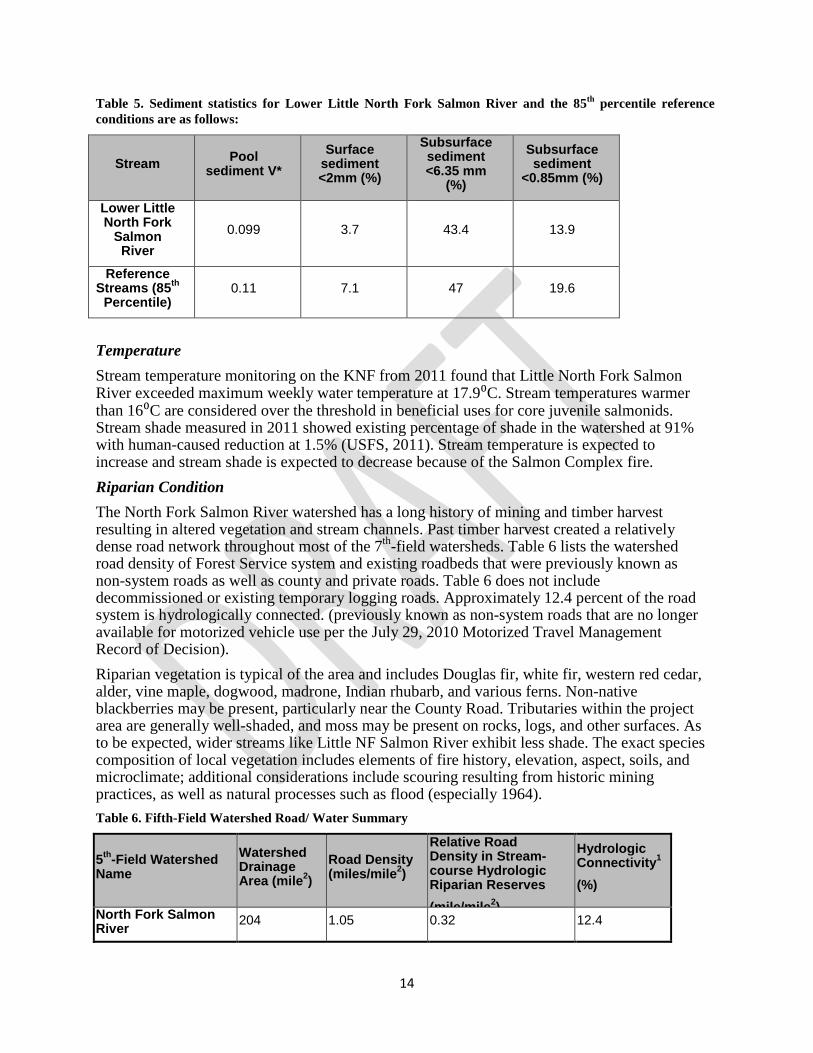
Channel Condition The 7th field sub-watersheds within the project area are characterized by well-confined, steep gradient, high-energy lower order-streams (Rosgen A-type channels). There is generally a high bedload sediment transport that often occurs with step-pool, cascading channel that is often influenced by the occurrence of large woody debris. The North Fork Salmon River is characterized by moderately entrenched systems with deposits from active and stabilized landslides and debris flows (Rosgen B-type channel; Rosgen, 1996). Most of these watersheds were severely burned by the Yellow wildfire in 1987. Storm events over the four winters that followed (1988 – 1991) delivered an estimated 14,600 cubic yards of sediment to the North Fork Salmon River from Olsen Creek (De la Fuente 1991). The underlying granitic parent material has a documented history of instability (both natural and human-caused) producing debris flows that strip away riparian vegetation and deliver sediment and fills into the North Fork Salmon River (De la Fuente et al. 2006). These past experiences combined with the predicted post-wildfire watershed response (Mikulvolsky and Bell 2013; Rust 2013) suggest that impacts to water quality are likely to occur over the next 5 years. Sediment Between 2009 and 2012 the Klamath National Forest measured streambed sediment in low gradient stream channels located near the mouth of 79 watersheds (USFS 2013). Reference watersheds are used to define desired conditions and serve as benchmarks to measure effects and manage watersheds. Managed watersheds include all watersheds that do not meet the criteria for reference streams. Reference conditions were developed from 20 reference streams for V*, percent fine sediment on the riffle-surface, and percent fine sediment in the streambed subsurface. The only stream within the project that was measured for V* was Little North Fork Salmon River. Stream sediment monitoring on the KNF from 2011 found that Little North Fork Salmon River (a managed stream) had a sediment indicator meeting reference conditions, however, stream sediment is expected to increase due to the Salmon Complex fire. As provided in the 2013 USFS report, “[t]he 85th percentile was selected to represent conditions that fully support beneficial uses based on the judgment of the North Coast Regional Water Quality Control Board.”
Sediment statistics for Lower Little North Fork Salmon River are shown in Table 5 below.
14
Table 5. Sediment statistics for Lower Little North Fork Salmon River and the 85th percentile reference conditions are as follows:
Stream Pool sediment V*
Surface sediment <2mm (%)
Subsurface sediment <6.35 mm
(%)
Subsurface sediment
<0.85mm (%)
Lower Little North Fork
Salmon River
0.099 3.7 43.4 13.9
Reference Streams (85th
Percentile) 0.11 7.1 47 19.6
Temperature Stream temperature monitoring on the KNF from 2011 found that Little North Fork Salmon River exceeded maximum weekly water temperature at 17.9⁰C. Stream temperatures warmer than 16⁰C are considered over the threshold in beneficial uses for core juvenile salmonids. Stream shade measured in 2011 showed existing percentage of shade in the watershed at 91% with human-caused reduction at 1.5% (USFS, 2011). Stream temperature is expected to increase and stream shade is expected to decrease because of the Salmon Complex fire. Riparian Condition The North Fork Salmon River watershed has a long history of mining and timber harvest resulting in altered vegetation and stream channels. Past timber harvest created a relatively dense road network throughout most of the 7th-field watersheds. Table 6 lists the watershed road density of Forest Service system and existing roadbeds that were previously known as non-system roads as well as county and private roads. Table 6 does not include decommissioned or existing temporary logging roads. Approximately 12.4 percent of the road system is hydrologically connected. (previously known as non-system roads that are no longer available for motorized vehicle use per the July 29, 2010 Motorized Travel Management Record of Decision). Riparian vegetation is typical of the area and includes Douglas fir, white fir, western red cedar, alder, vine maple, dogwood, madrone, Indian rhubarb, and various ferns. Non-native blackberries may be present, particularly near the County Road. Tributaries within the project area are generally well-shaded, and moss may be present on rocks, logs, and other surfaces. As to be expected, wider streams like Little NF Salmon River exhibit less shade. The exact species composition of local vegetation includes elements of fire history, elevation, aspect, soils, and microclimate; additional considerations include scouring resulting from historic mining practices, as well as natural processes such as flood (especially 1964). Table 6. Fifth-Field Watershed Road/ Water Summary
5th-Field Watershed Name
Watershed Drainage Area (mile2)
Road Density (miles/mile2)
Relative Road Density in Stream-course Hydrologic Riparian Reserves (mile/mile2)
Hydrologic Connectivity1 (%)
North Fork Salmon River 204 1.05 0.32 12.4
15
Sediment Cumulative watershed effects (CWE) are analyzed on the KNF using three models (see appendix B for detail on CWE methodology). The equivalent roaded area (ERA) methodology, a Region 5 standard, scales vegetative disturbances as being equivalent to a road. The “threshold of concern” (TOC), ranging from 4.5 to 17 percent, is the acceptable percent ERA within a particular watershed. The other two models predict sediment volume delivered to stream courses by surface soil erosion (USLE) and mass-wasting (GEO). A watershed’s TOC is reached when model-predicted current (accelerated) sediment delivery exceeds background by 400 and 200 percent for USLE and GEO, respectively. Table 15 lists the project watersheds current risk ratios for the three models.
USLE risk ratios are calculated by dividing accelerated sedimentation values due to surface sediment erosion by an inference point value of 400 percent. Accelerated sedimentation is figured as “percent over background,” which is calculated from ‘current’ model-estimated sediment delivery less background divided by background values. GEO risk ratios are calculated by dividing accelerated sedimentation values due to mass-wasting by an inference point value of 200 percent. Accelerated sedimentation is figured as “percent over background,” which is calculated from ‘current’ model-estimated sediment delivery less background divided by background values. ERA risk ratios are calculated by dividing ERA values by an inference point value equal to the Threshold of Concern.
All of the risk ratios within the project are under TOC for all models except for Lower Little North Fork Salmon River and Olsen Creek watersheds (Table 15). The high levels in GEO include highly erosive soils, past logging/roading, and fires, including the 2013 Salmon River Wildfire complex.
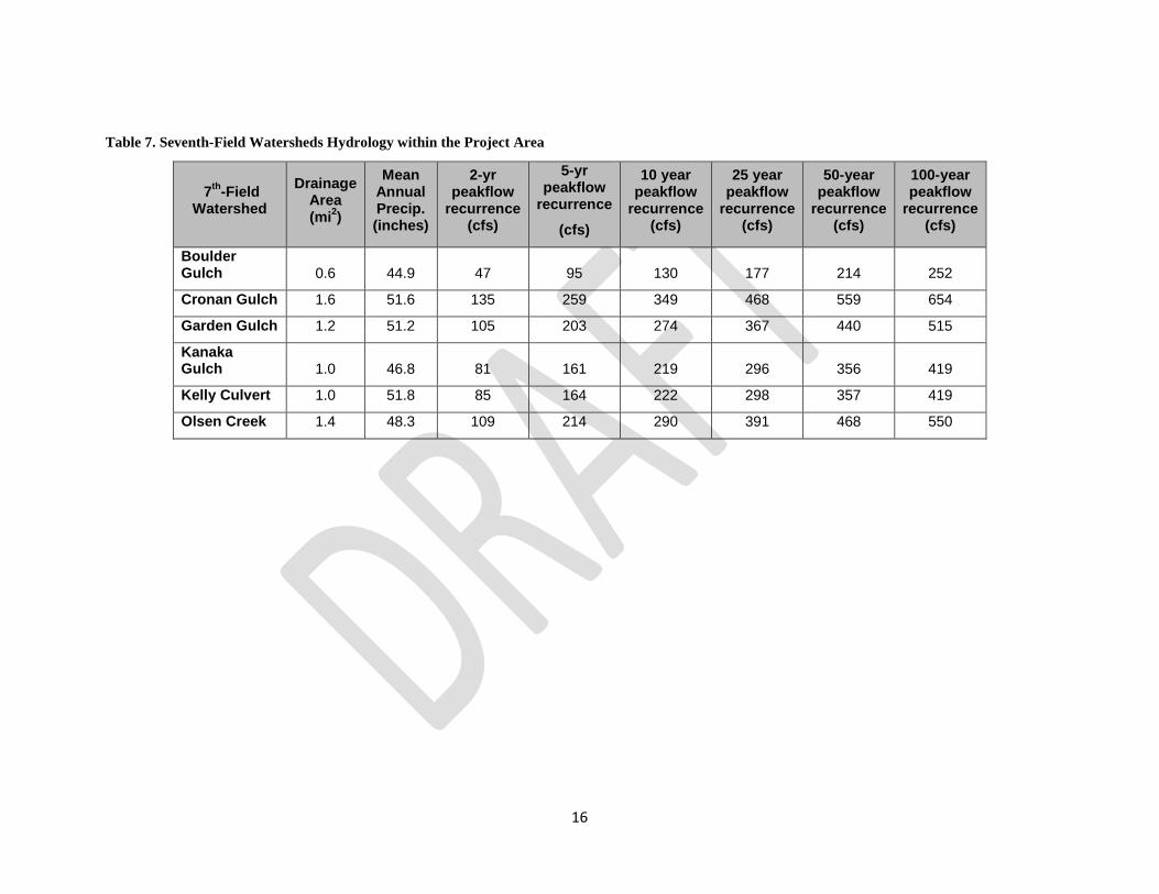
Peak and Base Flow Stream flow data is not available for this project. However, peak flows of various return intervals were estimated using USGS regression equations. Table 7 displays estimates of the 2, 10, 25, 50 and 100-year discharges for six streams within the project area. Both peak and base flow are expected to increase due to the Salmon Complex fire. See Table 4 for increases in peak flow.
16
Table 7. Seventh-Field Watersheds Hydrology within the Project Area
7th-Field Watershed
Drainage Area (mi2)
Mean Annual Precip. (inches)
2-yr peakflow
recurrence (cfs)
5-yr peakflow
recurrence
(cfs)
10 year peakflow
recurrence (cfs)
25 year peakflow
recurrence (cfs)
50-year peakflow
recurrence (cfs)
100-year peakflow
recurrence (cfs)
Boulder Gulch 0.6 44.9 47 95 130 177 214 252
Cronan Gulch 1.6 51.6 135 259 349 468 559 654
Garden Gulch 1.2 51.2 105 203 274 367 440 515
Kanaka Gulch 1.0 46.8 81 161 219 296 356 419
Kelly Culvert 1.0 51.8 85 164 222 298 357 419
Olsen Creek 1.4 48.3 109 214 290 391 468 550

17
Desired Condition The Klamath National Forest Land and Resource Management Plan (USFS, 1995) developed future desired conditions Forest-wide and in designated management areas. The Forest Service adopted the Aquatic Conservation Strategy for the Klamath National Forest (Forest Plan 4-6 and 4-7) and designated management area standards and guidelines in the Forest Plan to help achieve future desired conditions. Forest-wide Standards and Guidelines #1-3 for best management practices (BMPs) help meet geologic, water, soil and air quality objectives (LMRP, p. 4-18). Important Riparian Reserves (MA-10, 4-133 – 4-144) Standards and Guidelines are as follows: MA 10-2 identifying interim widths for Riparian Reserves MA 10-18 to -20 fish and wildlife habitat management MA 10-42, -48 and -53 roads management MA 10-54, -55, to -64 vegetation management MA 10-65 and -68 fire management The general forest-wide theme for the desired future condition of watersheds is that “[h]igh quality water in Forest streams and rivers will continue to provide the medium for healthy riparian and aquatic habitats” (Forest Plan, page 4-14). Watersheds in poor condition due to wildfire or legacy effects from land management will begin to respond to restoration practices. Important future desired conditions for Riparian Reserves are in the KNF Forest Plan (pp. 4-133 and 4-136). Desired conditions and management opportunities for Riparian Reserves and streams were identified in the North Fork Salmon River Ecosystem Analysis (USFS, 1995), as shown in Table 8 below. Table 8. Project related management opportunities that would help move the North Fork Salmon River watershed towards desired condition
Desired Condition Management Opportunity
Habitat is sufficient for sustainable populations of indigenous aquatic species. Fine sediment input, and accumulation are reduced to reference levels.
Promote and/or maintain vegetative growth, especially conifer, on burned land and on active landslides
Delineation of Riparian Reserves continues through the project level planning
Further refine delineation of Riparian Reserves at the project level to:
a) Facilitate project planning while meeting Riparian Reserves objectives;
b) Ensure location of Riparian Reserves in relation to project locations; and
c) Validate both watershed level and Forest Plan level Riparian Reserve mapping. Project level Riparian Reserve delineation should be completed in areas where management activities are planned.
18
Tributaries continue to provide cold, high quality water and perennial connection to the North Fork Salmon River
Design future management activities to maintain water quality, including suitable water temperatures. Protect mid to late seral stands from catastrophic wildfire. Insure the perennial connection of tributaries within North Fork Salmon River and smaller tributaries. Monitor crucial cold water streams.
Riparian vegetation conditions along North Fork Salmon River and its tributaries, tributaries to the Klamath River, and the mainstem Klamath are at full potential
Restore native vegetation, especially conifers, in Riparian Reserves. Increase the conifer component in riparian stands. Maintain conifer growth in riparian reserves located in plantations harvested prior to the establishment of the Aquatic Conservation Strategy objectives (usually along intermittent and in various plantations scattered throughout the analysis area, including those in LSRs).
Environmental Consequences Alternative 1 Direct and Indirect Effects Alternative 1 will not actively move existing conditions towards desired conditions. Most of the estimated 7,600 yd3 of fill material contained in legacy sites will discharge into tributaries of North Fork Salmon River in the short- and long-term, resulting in adverse effects to water quality. Without treatment, legacy sites will continue to produce soil erosion and increase the potential for landslides near streams and within unstable areas. Some of the legacy sites have been repaired during the Burned Area Emergency Response implementation; however, 16 legacy sites remain within the project area. Alternative 1 will not repair any legacy sites; the remaining legacy sites will continue to degrade and negatively affect water quality without repair.
Alternative 1 will not result in any short- or long-term improvements to watershed condition. Modeled risk ratios will slowly recover over time; stream sediment measured in response reaches is expected to remain the same or increase if untreated legacy sites continue to chronically or catastrophically fail over time.
The burned riparian areas will be left to recover naturally. Areas that were burned with a moderate to high intensity lost their duff layer which provided protection from erosional processes, provided a supply of nutrients to the soil, and acted as a natural reserve of nutrients for long-term soil productivity. Future fires will burn with higher intensities, which will delay recovery and further degrade watershed conditions. Cumulative Effects
Cumulative effects included analysis of the direct and indirect effects for the no action alternative described above combined with the existing condition and effects of reasonably foreseeable future actions at the 5th and 7th field watershed scale. All of the risk ratios within the project are under TOC for all models except for Lower Little North Fork Salmon River and Olsen Creek watersheds (Table 9). The high levels in GEO include highly erosive soils, past
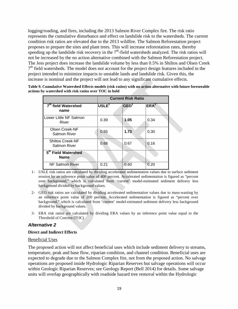
19
logging/roading, and fires, including the 2013 Salmon River Complex fire. The risk ratio represents the cumulative disturbance and effect on landslide risk to the watersheds. The current condition risk ratios are elevated due to the 2013 wildfire. The Salmon Reforestation project proposes to prepare the sites and plant trees. This will increase reforestation rates, thereby speeding up the landslide risk recovery in the 7th-field watersheds analyzed. The risk ratios will not be increased by the no action alternative combined with the Salmon Reforestation project. The Jess project does increase the landslide volume by less than 0.5% in Shiltos and Olsen Creek 7th field watersheds. The model does not account for the project design features included in the project intended to minimize impacts to unstable lands and landslide risk. Given this, the increase is nominal and the project will not lead to any significant cumulative effects. Table 9. Cumulative Watershed Effects models (risk ratios) with no action alternative with future foreseeable actions by watershed with risk ratios over TOC in bold
Current Risk Ratio
7th field Watershed name
USLE1 GEO2 ERA3
Lower Little NF Salmon River 0.39 1.05 0.34
Olsen Creek-NF Salmon River 0.55 1.73 0.30
Shiltos Creek-NF Salmon River 0.68 0.67 0.16
5th Field Watershed Name
NF Salmon River 0.21 0.60 0.20
1- USLE risk ratios are calculated by dividing accelerated sedimentation values due to surface sediment erosion by an inference point value of 400 percent. Accelerated sedimentation is figured as “percent over background,” which is calculated from ‘current’ model-estimated sediment delivery less background divided by background values.
2- GEO risk ratios are calculated by dividing accelerated sedimentation values due to mass-wasting by an inference point value of 200 percent. Accelerated sedimentation is figured as “percent over background,” which is calculated from ‘current’ model-estimated sediment delivery less background divided by background values.
3- ERA risk ratios are calculated by dividing ERA values by an inference point value equal to the Threshold of Concern (TOC)
Alternative 2 Direct and Indirect Effects
Beneficial Uses
The proposed action will not affect beneficial uses which include sediment delivery to streams, temperature, peak and base flow, riparian condition, and channel condition. Beneficial uses are expected to degrade due to the Salmon Complex fire, not from the proposed action. No salvage operations are proposed inside Hydrologic Riparian Reserves but salvage operations will occur within Geologic Riparian Reserves; see Geology Report (Bell 2014) for details. Some salvage units will overlap geographically with roadside hazard tree removal within the Hydrologic
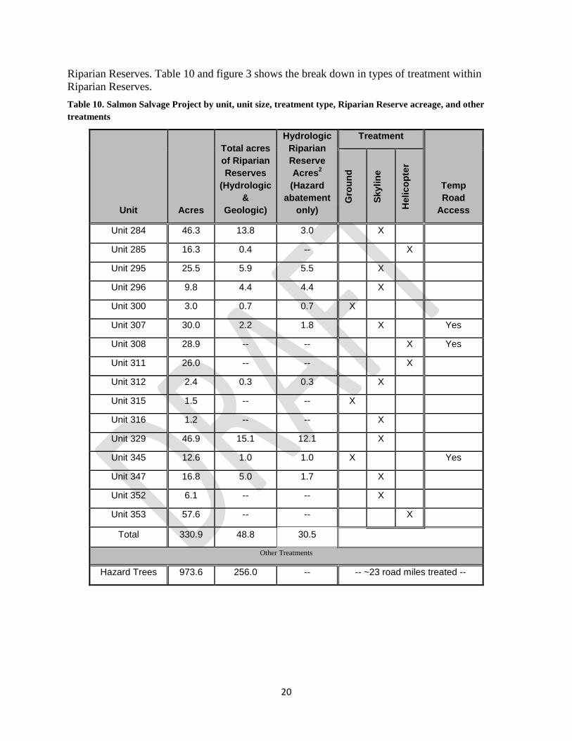
20
Riparian Reserves. Table 10 and figure 3 shows the break down in types of treatment within Riparian Reserves. Table 10. Salmon Salvage Project by unit, unit size, treatment type, Riparian Reserve acreage, and other treatments
Unit Acres
Total acres of Riparian Reserves
(Hydrologic &
Geologic)
Hydrologic Riparian Reserve Acres2 (Hazard
abatement only)
Treatment
Temp Road
Access
Gro
und
Skyl
ine
Hel
icop
ter
Unit 284 46.3 13.8 3.0
X
Unit 285 16.3 0.4 --
X
Unit 295 25.5 5.9 5.5
X
Unit 296 9.8 4.4 4.4
X
Unit 300 3.0 0.7 0.7 X
Unit 307 30.0 2.2 1.8
X
Yes
Unit 308 28.9 -- --
X Yes
Unit 311 26.0 -- --
X
Unit 312 2.4 0.3 0.3
X
Unit 315 1.5 -- -- X
Unit 316 1.2 -- --
X
Unit 329 46.9 15.1 12.1
X
Unit 345 12.6 1.0 1.0 X
Yes
Unit 347 16.8 5.0 1.7
X
Unit 352 6.1 -- --
X
Unit 353 57.6 -- --
X
Total 330.9 48.8 30.5
Other Treatments
Hazard Trees 973.6 256.0 -- -- ~23 road miles treated --
21
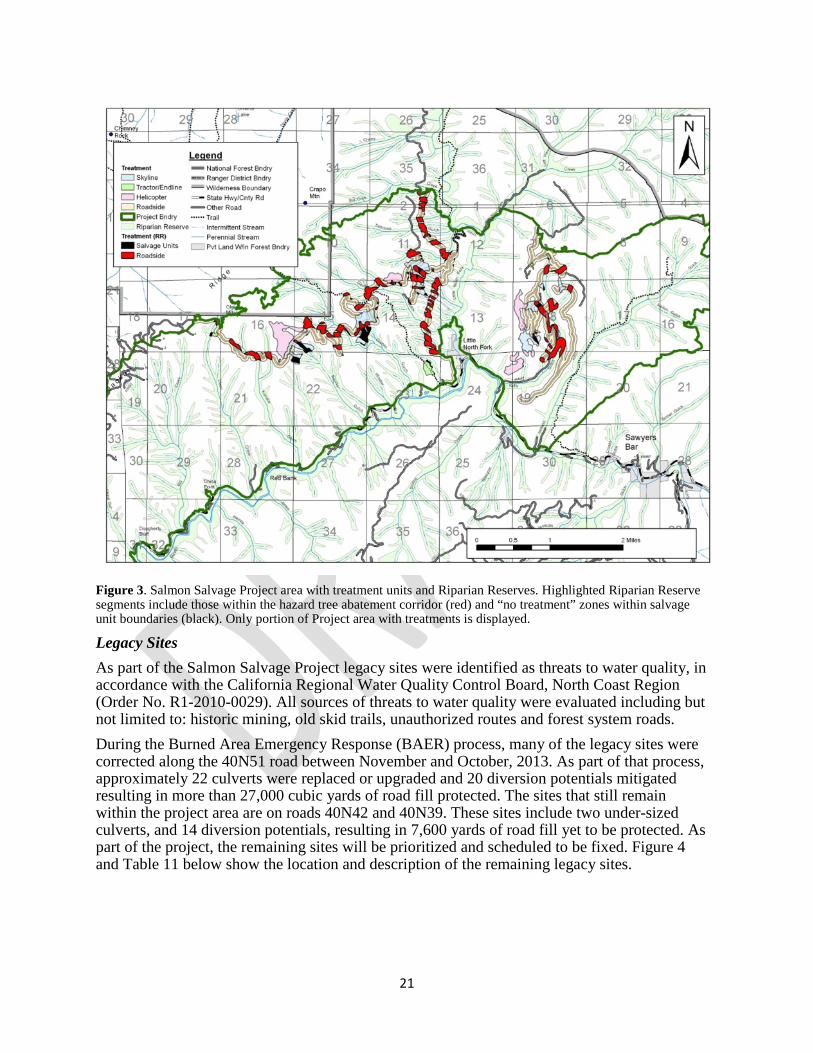
Figure 3. Salmon Salvage Project area with treatment units and Riparian Reserves. Highlighted Riparian Reserve segments include those within the hazard tree abatement corridor (red) and “no treatment” zones within salvage unit boundaries (black). Only portion of Project area with treatments is displayed.
Legacy Sites As part of the Salmon Salvage Project legacy sites were identified as threats to water quality, in accordance with the California Regional Water Quality Control Board, North Coast Region (Order No. R1-2010-0029). All sources of threats to water quality were evaluated including but not limited to: historic mining, old skid trails, unauthorized routes and forest system roads. During the Burned Area Emergency Response (BAER) process, many of the legacy sites were corrected along the 40N51 road between November and October, 2013. As part of that process, approximately 22 culverts were replaced or upgraded and 20 diversion potentials mitigated resulting in more than 27,000 cubic yards of road fill protected. The sites that still remain within the project area are on roads 40N42 and 40N39. These sites include two under-sized culverts, and 14 diversion potentials, resulting in 7,600 yards of road fill yet to be protected. As part of the project, the remaining sites will be prioritized and scheduled to be fixed. Figure 4 and Table 11 below show the location and description of the remaining legacy sites.

22
Figure 4. Map of Remaining Legacy Sites within the Project Area
Table 11. Remaining Legacy Sites within the Project Area
Name Description Notes Mitigation
40N39 - 0.03
Diversion Potential
Rolling Dip
40N39 - 0.13
Diversion Potential
Rolling Dip
40N39 - 0.20
Undersized Culvert
On main stem Kelly Gulch, also a fish passage issue Install 100 yr. culvert, reduce fill
40N42 - 0.30
Diversion Potential Bottom Part of Rock Pit Rolling Dip
40N42 - 0.46
Diversion Potential
Rolling Dip
40N42 - 0.59
Diversion Potential
Rolling Dip
40N42 - 0.79
Diversion Potential/
Undersized Culvert
Install 100 yr. culvert, reduce fill,
install rolling dip

23
40N42 - 0.86
Diversion Potential
Rolling Dip
40N42 - 0.95
Diversion Potential
Rolling Dip
40N42 - 1.83
Diversion Potential
Rolling Dip
40N42 - 1.87
Diversion Potential
Cross-Drain Culvert Relief Needs another culvert to reduce collection
potential. Install Cross-drain relief culvert
40N42 - 2.71
Diversion Potential
Rolling Dip
40N42 - 3.94
Diversion Potential
Rolling Dip
40N42 - 4.26
Diversion Potential
Fix diversion potential and reduce large fill volume
Rolling Dip and reduce Large fill volume
40N42 - 4.66
Diversion Potential
Rolling Dip
40N42 - 4.98
Diversion Potential
Rolling Dip
Cumulative Effects
The elevated risk ratio does not significantly change for Lower Little North Fork Salmon River and Olsen Creek-North Fork Salmon River from alternative 1 (Table 12), therefore the proposed action will not affect sediment regimes for those watersheds. All other watersheds are below the TOC. The cumulative effects of the proposed action result in greater improvements in watershed condition than alternative 1 because all potential sediment discharge sites (legacy sites) within the project area will be fixed which includes updating all culvert crossings to pass 100-yr. floods, fixing diversion potentials, and the reduction of large fills over culverts. The current condition risk ratios are elevated due to the 2013 wildfire. The Salmon Reforestation project proposes to prepare the sites and plant trees. This will increase reforestation rates, thereby speeding up the landslide risk recovery in the 7th field watersheds analyzed. The addition of the fire salvage and Salmon Reforestation activities increase the risk ratios by 0.09 for Lower Little North Fork Salmon River and 0.06 for Olsen Creek-North Fork Salmon River. The Jess project does increase the landslide volume by less than 0.5% in Shiltos and Olsen Creek 7th field watersheds. The model does not account for the project design features included in the project intended to minimize impacts to unstable lands and landslide risk. Given this, the increase is nominal and the project will not lead to any significant cumulative effects.

24
Table 12. Alternative 2’s influence on cumulative watershed effects risk ratios (numbers in parentheses indicate the increase in risk ratio from no action) The increases in risk ratio do not account for Legacy Site repairs
Risk Ratio after treatments (Increase in Risk Ratio)
7th field Watershed name USLE1 GEO2 ERA3
Lower Little NF Salmon River
0.39 (0.04)
1.05 (0.09)
0.34 (0.09)
Olsen Creek-NF Salmon River
0.55 (0.02)
1.73 (0.06)
0.30 (0.05)
Shiltos Creek-NF Salmon River
0.68 (0.04)
0.67 (0.11)
0.16 (0.08)
5th Field Watershed Name
NF Salmon River 0.21 (0.01)
0.60 (0.02)
0.20 (0.01)
Future foreseeable Federal actions include (1) Salmon Reforestation; (2) Jess Vegetation Management; and (3) Yellow Jacket Thinning and Fuel Break.
Within the Project area, a future foreseeable federal action is the Salmon Reforestation project. Analysis was underway at the time of this document. This project is expected to have a decision signed in mid-2014, with implementation concurrent with the Salmon Salvage Project. Proposed activities include replanting suitable areas within the Salmon Complex fire perimeter with conifer species, with a focus upon severely burned plantations. Where necessary, brush, undesirable hardwoods, and dead and dying conifers would be removed by hand to prepare sites for planting.
The activities of the Salmon Reforestation project overlap with the Salmon Salvage project, but there will be no cumulative impact. Cumulative watershed effects modeling is insensitive to low impact activities such as site preparation and tree planting, especially, as is this case, everything will be done by hand. Overall, additive disturbance by the two projects, even where planting is proposed to occur within salvage units, is not expected given prescription differences. Furthermore, the Salmon Complex Reforestation project is expected to accelerate recovery from salvage logging and the Salmon Complex fire by revegetating the portions of the landscape faster than possible given local conditions and seed bed reserves.
Adjacent to the Project area, a future foreseeable action is the Jess Vegetation Management project. Analysis was underway at the time of this document. This multi-year project is expected to have a decision signed in mid-2014, with implementation beginning that fall or in the year following. Proposed activities include variable-density thinning, pre-commercial thinning, pile burning and underburning, meadow restoration, legacy site repair, and water drafting. The Salmon Salvage Project and the Jess project intersect via the 7th-field watersheds of Olsen Creek-NF Salmon River and Shiltos Creek-NF Salmon River. These watersheds are “compound”,

25
meaning they consist of drainages north and south of the NF Salmon River which do not physically connect to each other.
The activities proposed by the Salmon Salvage Project minimally overlap with the Jess project. Both projects may utilize the same NF Salmon River drafting sites to attain water, but the overall use intensity is expected to be low, so there will be no additional impact to beneficial uses, sediment delivery to streams, changes in peak and base flow, changes in temperature, riparian condition, and channel condition/geomorphology. While there is no physical overlap of units, there will be overlap in affected 7th-field watersheds, however, the overall effect to the CWE models from these two projects is minimal, and there will not be sufficient cumulative effect to exceed model thresholds in the shared drainages, nor amplify metrics already over threshold. The CWE modeling for the Salmon Salvage project took into account the addition of the Jess project. As presented in Table 13 with the model effects of the Jess project removed, there is very little change in CWE output, and nothing sufficiently additive to be discernable over background variability or impact from the Salmon River Complex fire. Table 13. Comparison of CWE model outputs of shared 7th-field drainages – baseline, Salmon Salvage with all future activities, and Salmon Salvage without Jess project
Drainage Baseline
Salvage Project (with all future
activities) Salvage Project (without Jess)
ERA USLE GEO ERA USLE GEO ERA USLE GEO Olsen Creek-NF
Salmon River 0.30 0.55 1.73 0.34 0.57 1.79 0.33 0.57 1.79
Shiltos Creek-NF Salmon River 0.16 0.68 0.67 0.31 0.72 0.78 0.27 0.71 0.78
A third foreseeable Federal action with in the Project area is the Yellow Jacket Thinning and Fuel Break. Implementation is currently on-hold due to the Salmon Complex fire burning through the project area. Furthermore, suppression activities during the fire included the bulldozing of control lines along the ridge where the project’s shaded fuel break was planned; and some post-fire salvage and replanting activities (Salmon Salvage; Salmon Complex Reforestation) are occurring within units associated with the Yellow Jacket project. Therefore, the Yellow Jacket project is currently undergoing re-evaluation. It is near certain that the Salmon Salvage project, except for legacy repair in Kelly Gulch, will be fully implemented before the Yellow Jacket project is redesigned. Without an updated project description, consideration of cumulative effects cannot be determined; and by the time the Yellow Jacket project is reevaluated, Salmon Salvage will have become part of the baseline, existing environment.
Finally, while past events within the Project area e.g., mining, timber harvest, road building, grazing, flood, fire to the existing condition, this Project will not produce an additive effect.
In summary, there will be minimal cumulative impacts from future foreseeable actions. Where there is spatial or temporal overlap of projects currently undergoing implementation, they have already been accounted for in the existing environment. Where future actions do overlap with the Jess Vegetation Management Project, there will be insufficient additive impact to adversely affect anadromous salmonids, Forest Service Sensitive species, or Management Indicator Species.

26
Compliance with law, regulation, and policy
The intent of the Clean Water Act is met on National Forest System land by complying with water quality standards developed by the State of California, as authorized by the U.S. Environmental Protection Agency pursuant to the Federal Clean Water Act of 1972. The Porter-Cologne Act, California’s corresponding state law, assigns responsibility for protection of water quality within North Coast watersheds to the North Coast Regional Water Quality Control Board (NCRWQCB). The NCRWQCB implements and enforces the Porter-Cologne Act, and the Water Quality Control Plan for the North Coast Basin (Basin Plan). Water quality objectives are outlined in the Basin Plan. The primary purpose for maintaining water quality is to assure that the beneficial uses of water are not adversely affected. When water quality objectives are met, and beneficial uses protected, then the State considers that a project meets water quality standards.
The Forest Service entered into a Management Agency Agreement (1981) with the NCRWQCB and State of California requiring the Forest Service to institute a water quality management program to meet applicable water quality objectives and protect beneficial uses. Under the agreement, implementation of State-approved and Environmental Protection Agency (EPA)-certified best management practices (BMPs) are considered sufficient to protect water quality from non-point sources of pollution (USFS, 2000). Compliance with the Clean Water Act and the water quality objectives of the Basin Plan are achieved by meeting the conditions of the Waiver of Waste Discharge Requirements for Nonpoint Source Discharges Related to Certain Land Management Activities on National Forest System Lands (NCRWQCB Order No. R1-2010-0029; 2010 Waiver). Compliance with the conditions of the waiver also constitutes compliance with the sediment, temperature, dissolved oxygen, and nutrient requirements of the Klamath TMDL.
Alternative 3 Direct and Indirect Effects
Legacy site repair is the same for Alternative 2. Most activities required to support salvage harvest, such as landing and temporary road construction, would no longer be required, although water drafting for dust abatement may still occur.
Shading A Solar Pathfinder was used along Hydrologic Riparian Reserves adjacent to roads to measure current shade compared to estimated shade after hazard tree harvest. Solar Pathfinder measurements were conducted on February 21st and 27th, 2014 to evaluate the potential impact to stream shade due to hazard tree removal within the project. Fifty-one sites were measured and only six showed a measureable reduction in shade. For the six sites identified, only two showed a reduction in shade to less than 80% after salvage tree harvest. Both sites are small ephemeral channels with the total extent of reduction less than one-hundred feet of channel. The first site is on road 40N42 near road mile 2.7 and has an estimated reduction from 90% to 65% over forty feet of channel. The second site is on road 40N33 near road mile 0.3 and has an estimated reduction from 83% to 75% over twenty feet of channel. Both sites will not contribute to stream temperature increases due to the ephemeral nature of the streams. Although the other four sites measured had a reduction in shade, it was not less than 80% with the hazard tree removal.

27
Stream temperatures on the KNF are highest during summer months when the ephemeral streams will be dry, therefore, they will not have any effects to streams temperatures downstream.
Figure 5. Results of Solar Pathfinder Survey for Hazard Trees
Cumulative Effects
Alternative 3 will have less ground disturbance than alternative 2 which is reflected in the CWE models (Table 14). There will be no significant effects to water quality because the models either remain below the critical threshold or do not contribute to existing over-threshold risks. The current condition risk ratios are elevated due to the 2013 wildfire. The Salmon Reforestation project proposes to prepare the sites and plant trees. This will increase reforestation rates, thereby speeding up the landslide risk recovery in the 7th field watersheds analyzed. The addition of the fire salvage and Salmon Reforestation activities increase the risk ratios by 0.09 for Lower Little North Fork Salmon River and 0.06 for Olsen Creek-North Fork Salmon River. The Jess project does increase the landslide volume by less than 0.5% in Shiltos and Olsen Creek 7th field watersheds. The model does not account for the project design features included in the project intended to minimize impacts to unstable lands and landslide risk. Given this, the increase is nominal and the project will not lead to any significant cumulative effects. All other watersheds are below the TOC.

28
Table 14. Alternative 3’s influence on cumulative watershed effects risk ratios (numbers in parentheses indicate the increase in risk ratio from no action). The increases in risk ratio do not account for Legacy Site repairs
Risk Ratio after treatments (Increase in Risk Ratio)
7th field Watershed name USLE1 GEO2 ERA3
Lower Little NF Salmon River
0.39 (-.01) 1.05 (0) 0.34
(0.04)
Olsen Creek-NF Salmon River
0.55 (-.02) 1.73 (0) 0.30
(0.02)
Shiltos Creek-NF Salmon River 0.68 (0) 0.67
(0.01) 0.16 (0.08)
5th Field Watershed Name
NF Salmon River 0.21 (0) 0.60 (0.01)
0.20 (0.01)
Comparison of Effects
Table 15 displays a comparison of the effects on water quality risk ratios among alternatives.
Table 15. Comparison of effects of alternatives on water quality risk ratios. Risk Ratios (effects of legacy site repairs not included)
7th field Watershed name USLE GEO ERA
Alt. 1 Alt. 2 Alt. 3 Alt. 1 Alt. 2 Alt. 3 Alt. 1 Alt. 2 Alt. 3
Lower Little North Fork Salmon River
0.39 0.43 0.38 1.05 1.14 1.05 0.34 0.43 0.38
Olsen Creek-North Fork Salmon River
0.55 0.57 0.53 1.73 1.79 1.73 0.30 0.35 0.32
Shiltos Creek-North Fork Salmon River
0.68 0.72 0.68 0.67 0.78 0.68 0.16 0.31 0.24
North Fork Salmon River 5th Field
0.21 0.22 0.21 0.60 0.62 0.61 0.20 0.22 0.21
The modeled hydrologic differences in outputs and risk ratios for Alternatives 1, 2 and 3 would not change any of the drainages into a higher categorical risk status and would not be evident or measureable in the watershed. There is a lower risk of negative effects occurring for Alternative 3 versus 2, however, future fires would burn with higher intensities, which would delay recovery and further degrade watershed conditions.

29
Literature Cited De la Fuente, J. 1991. Effects of the intense summer storm at Kanaka and Olsen Creeks: Salmon River Ranger District, September 25, 1990. USDA, Forest Service, Klamath National Forest, Yreka, CA.
De la Fuente, J., E. Rose, and J. Davis. 2006. North Fork Salmon Roads Assessment: Geology/Geotech/Engineering Considerations. USDA, Forest Service, Klamath National Forest, Yreka, CA.
Gotvald, A.J., Barth, N.A., Veilleux, A.G., and Parrett, Charles. 2012. Methods for determining magnitude and frequency of floods in California, based on data through water year 2006: U.S. Geological Survey Scientific Investigations Report 2012–5113
Mikulovsky, R. and A. Bell. 2013. Salmon Complex BAER Geology Report. USDA, Forest Service, Klamath National Forest, Yreka, CA.
North Coast Regional Water Quality Control Board. 2010a. Order No. R1-2010-0029 Waiver of Waste Discharge Requirements for Nonpoint Source Discharges Related to Certain Federal Land Management Activities on National Forest System Lands in the North Coast Region.
North Coast Regional Water Quality Control Board. 2010b. Action Plan for the Klamath River Total Maximum Daily Loads.
North Coast Regional Water Quality Control Board. 2009. Staff Report for the 2008 Integrated Report for the Clean Water Act Section 305(b) Surface Water Quality Assessment and the 303(d) List of Impaired Waters (Table 10).
Rosgen, Dave. 1996. Applied river morphology. Pagosa Springs, CO: Wildland Hydrology. Variously paginated.
Rust, B. 2013. Salmon Complex BAER Soils Report. USDA, Forest Service, Klamath National Forest, Yreka, CA.
USFS, 2012. Regional Hazard Tree Guidelines for Forest Service Facilities and Roads in the Pacific Southwest Region. #RO-12-01.
USFS, 2013. Burned Area Emergency Response, Hydrology Specialist Report.
USFS, 2011. Forest Service Handbook Southwest Region (Region 5). Chapter 10-Water Quality Management Handbook.
USFS, 1995. Klamath National Forest North Fork Watershed Analysis. Step 3-2.
USFS. 2013. Stream Sediment Monitoring on the Klamath National Forest 2009 to 2012. Klamath National Forest.
USFS 2011. Stream Shade Monitoring on the Klamath National Forest, 2010.
USFS, 2012. Stream Temperature Monitoring on the Klamath National Forest, 2010 to 2011.
USFS, 2000. Water quality management for National Forest system lands in California – Best Management Practices. Pacific Southwest Region, Vallejo, California.
USFS, 2010. Klamath National Forest’s Land and Resource Management Plan, Capter 4. USDA-Forest Service, PSW Region, Klamath National Forest, Yreka, California.

30
USFS, 2011. Marking guidelines for fire-injured trees in California. Report #RO-11-01. U.S. Forest Service, Pacific Southwest Region, Vallejo, CA. 15 p.

A-1
Appendix A - Aquatic Conservation Strategy
The Klamath National Forest (KNF) Land and Resource Management Plan (Forest Plan) contains the components, objectives and standards and guidelines for consistency of projects with the Aquatic Conservation Strategy (ACS). The Record of Decision (ROD) for the KNF Forest Plan (USFS, 2010) is the guiding document for KNF projects; the KNF ROD incorporates the ACS standards and guidelines from the ROD for Amendments to Forest Service and Bureau of Land Management Planning Documents within the Range of the Northern Spotted Owl (commonly known as the Northwest Forest Plan) (USDA Forest Service and USDI Bureau of Land Management 1994b). The KNF Forest Plan lists four components of the ACS, as stated on pages 4-25 through 4-27 of the KNF Forest Plan: “1) Riparian Reserves, 2) Key Watersheds, 3) Watershed Analysis and 4) Watershed Restoration” (USDA Forest Service 1995). The Salmon Fire Salvage Project addresses these components as follows:
1. Riparian Reserves: No salvage operations are proposed inside stream-course (hydrologic) Riparian Reserves but salvage operations will occur within Riparian Reserves on unstable or potentially unstable lands (geologic Riparian Reserves). Riparian Reserve buffers will apply to all units; there will be no salvage harvesting within the hydrologic Riparian Reserve (Table 10). Treatment prescriptions for project units were developed with input from wildlife and fish specialists and earth scientists to insure that Forest Plan direction, including the Aquatic Conservation Strategy, was met. Protection measures were integrated as guided by Best Management Practices from the Pacific Southwest Region (R-5) Water Quality Management for Forested Lands in California: Best Management Practices (USFS 2000) and Water Quality Management Handbook (USDA 2011). Project-specific Best Management Practices and project design features were developed to reduce negative effects of the project and meet the requirement of the Forest Plan (p. 4-106) to prohibit and regulate activities in Riparian Reserves that can retard or prevent attainment of the Aquatic Conservation Strategy objectives.
2. Key Watersheds: The Salmon Salvage project is in a Key Watershed so standards and guidelines related to key watersheds are addressed in this project. One Forest-wide standard and guideline (6-27) requires the completion of watershed analysis prior to timber harvest, including salvage (Forest Plan, page 4-25).
3. Watershed Analysis: Initial watershed analysis was completed for the Salmon Salvage area and is documented in the North Fork Watershed Analysis (USFS Forest Service 1995); information from this analysis is used when locating and designing proposed activities for the Salmon Salvage project. Recommendations from the watershed analysis related to the purpose and need of this project are considered in developing treatments, prescriptions and project design features.
4. Watershed Restoration: Watershed restoration, including fish passage improvement, removing and upgrading roads, and restoration of large trees in Riparian Reserves, is an ongoing program on the Forest but not part of the purpose and need for the Salmon Salvage project. However, proposed treatments in the project contribute to watershed restoration, especially repairing the legacy sites. Legacy-site repairs include removing diversion potentials, installing rolling dips that reduce fills, and upgrading culverts to pass 100-year floods (Forest Plan standard 6-31, page 4-25). Hydrological restoration
A-2
of temporary roads used in the project after their use will also contribute to watershed restoration.
Alternatives for the project are evaluated to determine the effects to hydrologic (stream-course) Riparian Reserves at the site, reach, and 7th and 5th field watershed scales in the short and long term to determine effects on water quality, and on anadromous fish and their habitat. Both hydrologic Riparian Reserves and those on unstable and potentially unstable lands (geologic Riparian Reserves) are included in the analysis and evaluation. Additionally, replacing the Kelly Gulch culvert with a structure that allows fish passage (and can sustain 100-year flood events) will have a measurable beneficial effect by removing the last man-made barrier to fish occupancy within the sub-drainage. Salvage harvest will reduce post-fire fuel concentrations in treated areas, thus decreasing the potential for a high-intensity re-burn that could kill most vegetation, especially within the Riparian Reserve and be detrimental to the watershed.
The conclusions of these evaluations for each alternative are summarized, by the nine Aquatic Conservation Strategy objectives, as follows:
Alternative 1
1. Maintain and restore the distribution, diversity, and complexity of watershed and landscape-scale features to ensure protection of the aquatic systems to which species, populations and communities are uniquely adapted.
In the short term, alternative 1 will maintain the distribution, diversity and complexity of watershed and landscape-scale features that resulted from the Salmon River Complex fires; these features are not those that ensure protection of aquatic systems. In the long term, alternative 1 will maintain the current sediment regime but not move quickly toward restoring the sediment regime since this alternative will increase and not decrease the likelihood of negative effects due to high intensity wildfires. Legacy sites will not be repaired in this alternative; thus the improvement of water quality will be delayed.
2. Maintain and restore spatial and temporal connectivity within and between watersheds. Lateral, longitudinal, and drainage network connections include floodplains, wetlands, upslope areas, headwater tributaries, and intact refugia. These network connections must provide chemically and physically unobstructed routes to areas critical for fulfilling life history requirements of aquatic- and riparian-dependent species.
Alternative 1 will not affect spatial and temporal connectivity within and between watersheds.
3. Maintain and restore the physical integrity of the aquatic system, including shorelines, banks, and bottom configurations.
Alternative 1 will maintain the physical integrity of the aquatic system as it now exists since no action will be taken.
4. Maintain and restore water quality necessary to support healthy riparian, aquatic, and wetland ecosystems. Water quality must remain within the range that maintains the biological, physical, and chemical integrity of the system and benefits survival, growth, reproduction and migration of individuals composing aquatic and riparian communities.
A-3
In the short term, alternative 1 will maintain the water quality that exists after the Salmon River Complex fires. In the long term, as natural re-vegetation to shrubs and grasses progresses, the area will move toward restoring water quality unless a high-intensity wildfire in the areas that are proposed for salvage in alternative 2 again reduces or eliminates vegetative cover near streams.
5. Maintain and restore the sediment regime under which aquatic ecosystems evolved. Elements of the sediment regime include the timing, volume, rate, and character of sediment input, storage and transport.
The Salmon River Complex has caused the reduction of interception by vegetation, increasing direct precipitation on bare ground which has increased the landslide potential for the project area. The result of the increased landslide potential is a modified sediment regime. Debris flow is the primary landsliding process on the severely weathered granitic lands (geologic Riparian Reserve) in the project area. Debris flows can introduce sediment to a stream, modify where sediment is stored in the channel and impact bank stability. The landslide potential will remain elevated until the area is forested. Alternative 1 will have slow re-vegetation by shrubs and grasses; therefore, the post-fire sediment regime will continue in the short term. In the long term, increased likelihood of re-burning by high intensity wildfire will make restoration of the pre-fire sediment regime slow, if at all possible.
6. Maintain and restore in-stream flows sufficient to create and sustain riparian, aquatic, and wetland habitats, and to retain patterns of sediment, nutrient, and wood routing. The timing, magnitude, duration, and spatial distribution of peak, high, and low flows must be protected.
This alternative will not affect the timing, magnitude, duration, and spatial distribution of peak, high, and low flows. Wood routing will increase; dead or dying trees will eventually fall over and increase large wood recruitment into streams.
7. Maintain and restore the timing, variability, and duration of floodplain inundation and water table elevation in meadows and wetlands.
There are no meadows or wetlands within the project so there is no effect of this alternative on them.
8. Maintain and restore the species composition and structural diversity of plant communities in riparian areas and wetlands to provide adequate summer and winter thermal regulation, nutrient filtering, appropriate rates of surface erosion, bank erosion, and channel migration and to supply amounts and distributions of coarse woody debris sufficient to sustain physical complexity and stability.
Post-fire species composition of plant communities in riparian areas will be maintained in the short term. In the long term, there will be an increased growth of shrubs and grasses in these areas. The increased risk of stand-replacing fire in riparian areas will hinder the re-growth of pre-fire vegetation. Structural diversity will be maintained by leaving snags within areas connected to the aquatic system. Large woody debris will be left in hydrologic Riparian Reserves, ensuring recruitment into streams and within the riparian

A-4
area. Large woody debris will retard erosion and trap fine sediment as the forest recovers from the Salmon River Complex fire but future wildfires are likely to retard this recovery.
9. Maintain and restore well-distributed populations of native plant, invertebrate and vertebrate riparian-dependent species.
This alternative will not aid in a well-distributed population of native plant, invertebrate, and vertebrate riparian-dependent species because it will not decrease the likelihood of high intensity fire not speed the recovery of habitat for forest wildlife species.
Alternative 2
1. Maintain and restore the distribution, diversity, and complexity of watershed and landscape-scale features to ensure protection of the aquatic systems to which species, populations and communities are uniquely adapted.
In the short term, alternative 2 will: (1) increase sedimentation at the site- and reach-scale due to ground disturbance and/or vegetation removal in the roadside hazard tree removal areas within stream-course (hydrologic) Riparian Reserves; (2) decrease the risk of moderate- to high-intensity wildfire in treated areas; and (3) increase sedimentation at legacy sites due to ground disturbance and/or vegetation removal (i.e., fixing diversion potentials, upgrading culverts). In the long term, alternative 2 will maintain the current sediment regime or move toward restoring the sediment regime by decreasing the likelihood of negative effects due to high intensity wildfires. Alternative 2 will not include salvage in hydrologic Riparian Reserves (170’ for non-fish bearing streams and 340’ for fish-bearing streams). This will encourage large woody recruitment into streams while providing diversity and complexity for aquatic and nonaquatic species. Additionally, fixing legacy sites will move towards restoring the sediment regime by decreasing the impact of the roaded areas to stream habitat including water quality.
2. Maintain and restore spatial and temporal connectivity within and between watersheds. Lateral longitudinal, and drainage network connections include floodplains, wetlands, upslope areas, headwater tributaries, and intact refugia. These network connections must provide chemically and physically unobstructed routes to areas critical for fulfilling life history requirements of aquatic- and riparian-dependent species.
The project includes upgrade of an undersized culvert and documented fish barrier at Kelly Gulch. This culvert replacement will improve and restore connectivity in this sub-watershed, and encourage species diversity, by providing for free passage of aquatic organisms throughout Kelly Gulch and opening up access to additional spawning habitat for salmonids. The other legacy site repair actions include constructing dips at stream crossings to eliminate diversion potential, reducing road fill volumes at stream crossings to withstand 100-year peak flows and debris flows, and constructing rolling dips and waterbars to reduce concentration of overland run-off. These actions also assist in maintaining and restoring physically unobstructed routes for aquatic species because they reduce sediment inputs to streams from roads and reduce stream diversion potential at road crossings. The other proposed actions in alternative 2 do not occur near streams and therefore will not affect spatial and temporal connectivity within and between watersheds.
A-5
3. Maintain and restore the physical integrity of the aquatic system, including shorelines, banks, and bottom configurations.
Salvage operations will not take place in hydrologic Riparian Reserves so this will maintain the physical integrity of the aquatic system. As described for objective #2, proposed legacy site repair will reduce the impacts of roads on streams, allowing for improved integrity of aquatic systems. At the Kelly Gulch crossing upgrade post project, the slope and substrate will align with historical condition and a more natural local hydrologic condition will be restored. Roadside hazard tree removal may occur within hydrologic Riparian Reserves. Due to the potential to affect National Forest user safety and road system integrity, hazard trees felled above the road may be removed. In Riparian Reserves hazard trees located below roads will be left on-site. Directional felling of hazard trees will be utilized as needed to eliminate any impact to streambanks, therefore there will be no effect to the physical integrity of the aquatic system.
4. Maintain and restore water quality necessary to support healthy riparian, aquatic, and wetland ecosystems. Water quality must remain within the range that maintains the biological, physical, and chemical integrity of the system and benefits survival, growth, reproduction and migration of individuals composing aquatic and riparian communities.
In the short term, there may be minor negative effects to sediment movement related to ground-disturbing actions such as road crossing upgrades and water drafting. These actions can affect sedimentation, and/or channel geomorphology, at the site-scale but not more than 300 feet downstream. Due to the upslope location of the project and its distance from fish-occupied waters, project design features and Best Management Practices designed for the project are considered to be adequate to control overland movement of sediment. Effects of this alternative will not be meaningful at the watershed scale because of the limited acreage of treatments relative to watershed size and the low intensity and magnitude of potential changes to the sediment regime. Additionally, fixing legacy sites will move toward restoring the sediment regime by decreasing the impact of the roaded areas, which will improve water quality, and benefit survival, growth, reproduction, and migration of aquatic and riparian communities.
5. Maintain and restore the sediment regime under which aquatic ecosystems evolved. Elements of the sediment regime include the timing, volume, rate, and character of sediment input, storage and transport.
In discussing the effects to water quality, objective #4 also provides information on maintenance and restoration of the sediment regime in existence before the Salmon River Complex fire. The Salmon River Complex has caused the reduction of interception by vegetation, increasing direct precipitation on bare ground which has increased the landslide potential for the project area. The result of the increased landslide potential is a modified sediment regime. Debris flow is the primary landsliding process on the severely weathered granitic lands (geologic Riparian Reserve) in the project area. Debris flows can introduce sediment to a stream, modify where sediment is stored in the channel and impact bank stability. The landslide potential will remain elevated until the area is forested. Project design features will minimize direct impacts to the landslide potential from this alternative at the site scale. The salvage of fire-killed trees will accelerate the re-

A-6
establishment of conifer forest in the project area compared to areas without salvage. By increasing the rate of reforestation, the project will speed up the reduction of landslide potential on severely weathered granitic lands (geologic Riparian Reserve). The alternative will reduce the time needed to return the landslide-related sediment regime to desired conditions under the Aquatic Conservation Strategy at the site scale and contribute to the trend of decreased landslide potential in the long-term at the 5th field watershed scale.
6. Maintain and restore in-stream flows sufficient to create and sustain riparian, aquatic, and wetland habitats, and to retain patterns of sediment, nutrient, and wood routing. The timing, magnitude, duration, and spatial distribution of peak, high, and low flows must be protected.
The wildfire caused changes to the magnitude (and timing/duration/spatial distribution) of all flows (peak and base) by increasing the magnitude, timing, duration, and spatial distribution. The lack of vegetation, bare ground and dead trees will decrease interception, evapotranspiration and infiltration, therefore increasing runoff into streams. This alternative involves limited ground disturbance related to infrastructure (temporary roads and landings) that will add some risk to further changes to these processes. This alternative will also allow for quicker reforestation within salvaged areas which will reduce the time needed for these processes to recover to pre-fire conditions. This alternative includes the salvage of dead or dying trees, fuel treatment, and hazard tree removal; these activities will not affect the timing, magnitude, duration, and spatial distribution of peak, high, and low flows. Wood routing will increase since there are no salvage harvest activities within hydrologic Riparian Reserves, thus leaving the dead or dying trees which will eventually fall over and increase large wood recruitment into streams. This alternative will not impact the trend of peak flows moving toward reference conditions at the 5th field watershed scale.
7. Maintain and restore the timing, variability, and duration of floodplain inundation and water table elevation in meadows and wetlands.
There are no meadows or wetlands within the project so there will be no effect on them from this alternative. As described for objective #6, the wildfires resulted in changes to the processes that control peak/base flows and timing/variability/duration of floodplain inundation. The short-term effects of this alternative are not likely to result in further negative effects to these processes. The long-term effects of this alternative are likely to accelerate recovery to pre-fire conditions.
8. Maintain and restore the species composition and structural diversity of plant communities in riparian areas and wetlands to provide adequate summer and winter thermal regulation, nutrient filtering, appropriate rates of surface erosion, bank erosion, and channel migration and to supply amounts and distributions of coarse woody debris sufficient to sustain physical complexity and stability.
Species composition of plant communities in riparian areas will be maintained or restored through reducing the risk of stand-replacing fire in geologic Riparian Reserves. Structural diversity will be maintained or restored by leaving snags within areas connected to the aquatic system. Large woody debris will be left in hydrologic Riparian Reserves ensuring recruitment into streams and within the riparian area. Large woody debris will retard

A-7
erosion and trap fine sediment as the forest recovers from the Salmon River Complex. Only some hazard trees will be removed in Riparian Reserves (when situated above a road); this minor amount of snag removal will not affect species composition or structural diversity.
9. Maintain and restore well-distributed populations of native plant, invertebrate and vertebrate riparian-dependent species.
This alternative will aid in restoring a well-distributed population of native plant, invertebrate, and vertebrate riparian-dependent species by keeping salvage treatments out of hydrologic Riparian Reserves and allowing for faster recovery of watershed processes. Also, the Kelly Gulch culvert replacement will restore the potential distribution of aquatic organisms in the drainage.
Alternative 3
1. Maintain and restore the distribution, diversity, and complexity of watershed and landscape-scale features to ensure protection of the aquatic systems to which species, populations and communities are uniquely adapted.
The effects of this alternative will be the same as alternative 2 for areas receiving roadside hazard treatments and the same as alternative 1 for other areas since no salvage treatments will occur in this alternative.
2. Maintain and restore spatial and temporal connectivity within and between watersheds Lateral longitudinal, and drainage network connections include floodplains, wetlands, upslope areas, headwater tributaries, and intact refugia. These network connections must provide chemically and physically unobstructed routes to areas critical for fulfilling life history requirements of aquatic- and riparian-dependent species.
The effects of this alternative will be the same as alternative 2 since the Kelly Gulch culvert will be replaced.
3. Maintain and restore the physical integrity of the aquatic system, including shorelines, banks, and bottom configurations.
The effects of this alternative will be the same as alternative 2 for areas receiving roadside hazard treatments and the same as alternative 1 for other areas since no salvage treatments will occur in this alternative.
4. Maintain and restore water quality necessary to support healthy riparian, aquatic, and wetland ecosystems. Water quality must remain within the range that maintains the biological, physical, and chemical integrity of the system and benefits survival, growth, reproduction and migration of individuals composing aquatic and riparian communities.
The effects of this alternative will be the same as alternative 2 for areas receiving roadside hazard treatments and the same as alternative 1 for other areas since no salvage treatments will occur in this alternative.
A-8
5. Maintain and restore the sediment regime under which aquatic ecosystems evolved. Elements of the sediment regime include the timing, volume, rate, and character of sediment input, storage and transport.
The effects of this alternative will be the same as alternative 2 for areas receiving roadside hazard treatments and the same as alternative 1 for other areas since no salvage treatments will occur in this alternative.
6. Maintain and restore in-stream flows sufficient to create and sustain riparian, aquatic, and wetland habitats, and to retain patterns of sediment, nutrient, and wood routing. The timing, magnitude, duration, and spatial distribution of peak, high, and low flows must be protected.
The effects of this alternative will be the same as alternative 2 for areas receiving roadside hazard treatments and the same as alternative 1 for other areas since no salvage treatments will occur in this alternative.
7. Maintain and restore the timing, variability, and duration of floodplain inundation and water table elevation in meadows and wetlands.
There are no meadows or wetlands within the project so there are no effects of this alternative.
8. Maintain and restore the species composition and structural diversity of plant communities in riparian areas and wetlands to provide adequate summer and winter thermal regulation, nutrient filtering, appropriate rates of surface erosion, bank erosion, and channel migration and to supply amounts and distributions of coarse woody debris sufficient to sustain physical complexity and stability.
The effects of this alternative will be the same as alternative 2 for areas receiving roadside hazard treatments and the same as alternative 1 for other areas since no salvage treatments will occur in this alternative.
9. Maintain and restore well-distributed populations of native plant, invertebrate and vertebrate riparian-dependent species.
The effects of this alternative will be the same as alternative 2 for areas receiving roadside hazard treatments and the same as alternative 1 for other areas since no salvage treatments will occur in this alternative.

A-9

B-1
Appendix B: Cumulative Watershed Effects Modeling Results
Table 16. Results for the Salvage Project Alternative 2 for the ERA model
Table 17. Results for the Salvage Project Alternative 2 for the GEO model
Table 18. Results for the Salvage Project Alternative 2 for the USLE model
HUC 14 HUC 14 Name TOC
HUC 14 Area (acres) Current project
future (Butler & Salmon CE)
future (Jess Project) Roads
Saved by road treatments
Temp Rd on existing roadbed
Saved by temp road decom Total ERA
Risk Ratio
18010210020604 Lower Little North Fork Salmon River 6.5% 4930 84 28 0.1 0 61 -37 0.0 0.0 137 0.4318010210020706 Shiltos Creek-North Fork Salmon River 9.5% 3910 29 39 0.1 13 97 -65 0.2 -0.2 114 0.3118010210020801 Olsen Creek-North Fork Salmon River 10.0% 8297 224 24 0.1 12 103 -77 0.6 -0.4 286 0.35
HUC 14 HUC 14 Namebackground current project
future (Butler & Salmon CE)
future (Jess) Roads
Saved by road treatments
Temp Rd on existing roadbed
Saved by temp road decom
Alt 2. total GEO CWE
Alt. 2 Risk Ratio
18010210020604 Lower Little North Fork Salmon River 12221 15542 2148 0 0 13187 -3109 39990 1.1418010210020706 Shiltos Creek-North Fork Salmon River 7331 1494 1547 0 69 9501 -1107 19 -14 18840 0.7818010210020801 Olsen Creek-North Fork Salmon River 18624 51088 1991 0 12 15007 -1550 15 -10 85178 1.79
HUC 14 HUC 14 Name background current project
future (Butler & Salmon CE)
future (Jess) Roads
Saved by road treatments
Temp Rd on existing roadbed
Saved by temp road decom
Total USLE CWE
Project Risk Ratio
18010210020604 Lower Little North Fork Salmon River 215 215 259 32 0 0 114 -36 583 58318010210020706 Shiltos Creek-North Fork Salmon River 81 81 50 10 0 2 255 -84 0.3 314 31418010210020801 Olsen Creek-North Fork Salmon River 246 246 403 21 0 1 176 -43 0.8 803 803

B-2
Table 19. Results for the Salvage Project Alternative 3 for the ERA model
Table 20. Results for the Salvage Project Alternative 3 for the GEO model
Table 21. Results for the Salvage Project Alternative 3 for the USLE model
HUC 14 HUC 14 Name TOC
HUC 14 Area (acres) Current project
future (Butler & Salmon CE)
future (Jess Project) Roads
Saved by road treatments
alt 3. total ERA
alt. 3 Risk Ratio
18010210020604 Lower Little North Fork Salmon River 6.5% 4930 80.22 17 0.1 0 61 -37 122 0.3818010210020706 Shiltos Creek-North Fork Salmon River 9.5% 3910 26.83 18 0.1 13 97 -65 91 0.2418010210020801 Olsen Creek-North Fork Salmon River 10.0% 8297 221.50 7 0.1 12 103 -77 267 0.32
HUC 14 HUC 14 Name background current project
future (Butler & Salmon CE)
future (Jess) Roads
Saved by road treatments
alt. 3 total GEO CWE
alt. 3 Risk Ratio
18010210020604 Lower Little North Fork Salmon River 12221 15542 0 0 0 13187 -3109 37841 1.0518010210020706 Shiltos Creek-North Fork Salmon River 7331 1494 0 0 69 9501 -1107 17288 0.6818010210020801 Olsen Creek-North Fork Salmon River 18624 51088 0 0 12 15007 -1550 83182 1.73
HUC_14 HUC 14_NAME background current project
future (Butler & Salmon CE) future (JesRoads
Saved by road treatments
alt. 3 Total USLE CWE
alt. 3 Risk Ratio
18010210020604 Lower Little North Fork Salmon River 212 241 0 0 0 114 -36 531 0.3818010210020706 Shiltos Creek-North Fork Salmon River 81 44 0 0 2 255 -84 298 0.6818010210020801 Olsen Creek-North Fork Salmon River 245 387 0 0 1 176 -43 765 0.53