Embed Size (px)
Citation preview
1
Hydrology
East Fork Illinois River Channel and Floodplain Restoration Project
Wild Rivers Ranger District, Rogue River-Siskiyou National Forest
/s/ Jamie Krezelok Date: January 23, 2015
Jamie Krezelok, Hydrologist
2
I. Introduction
This report will describe and analyze effects to existing aquatic resources within the East Fork Illinois
River Channel and Floodplain Restoration Project area, specifically water quality including, temperature,
clarity and chemistry and stream channel morphology, including function and condition. The project area
is located in the East Fork Illinois River 5th field watershed (1710031103) which contains the Dunn Creek
(171003110302), Upper East Fork Illinois River (171003110301), and Lower East Fork Illinois River
(171003110303) subwatersheds. There are no projects proposed in the Lower East Fork watershed since
most of the land is private. Land ownership within the watersheds is shown in Table 1.
Table 1. Watershed Area and Ownership Distribution
6th
Field Watersheds
Total
Acres
Land Ownership
USFS* Private Lands BLM* State Lands
acres % acres % acres % acres %
Upper East Fork
Illinois River 10,319 10,319 100% 0 0% 0 0% 0 <1%
Dunn Creek
Priority
Subwatershed
16,509 16,273 98% 236 2% 0 0% 0 0%
Lower East Fork
Illinois River 30,952 9,590 31% 16,270 53% 5,092 16% 0 0%
5th
Field TOTAL 57,779 36,182 -- 16,506 -- 5,092 -- 0 --
* USFS = Forest Service; BLM = Bureau of Land Management
II. Background and Affected Environment
Analysis Area
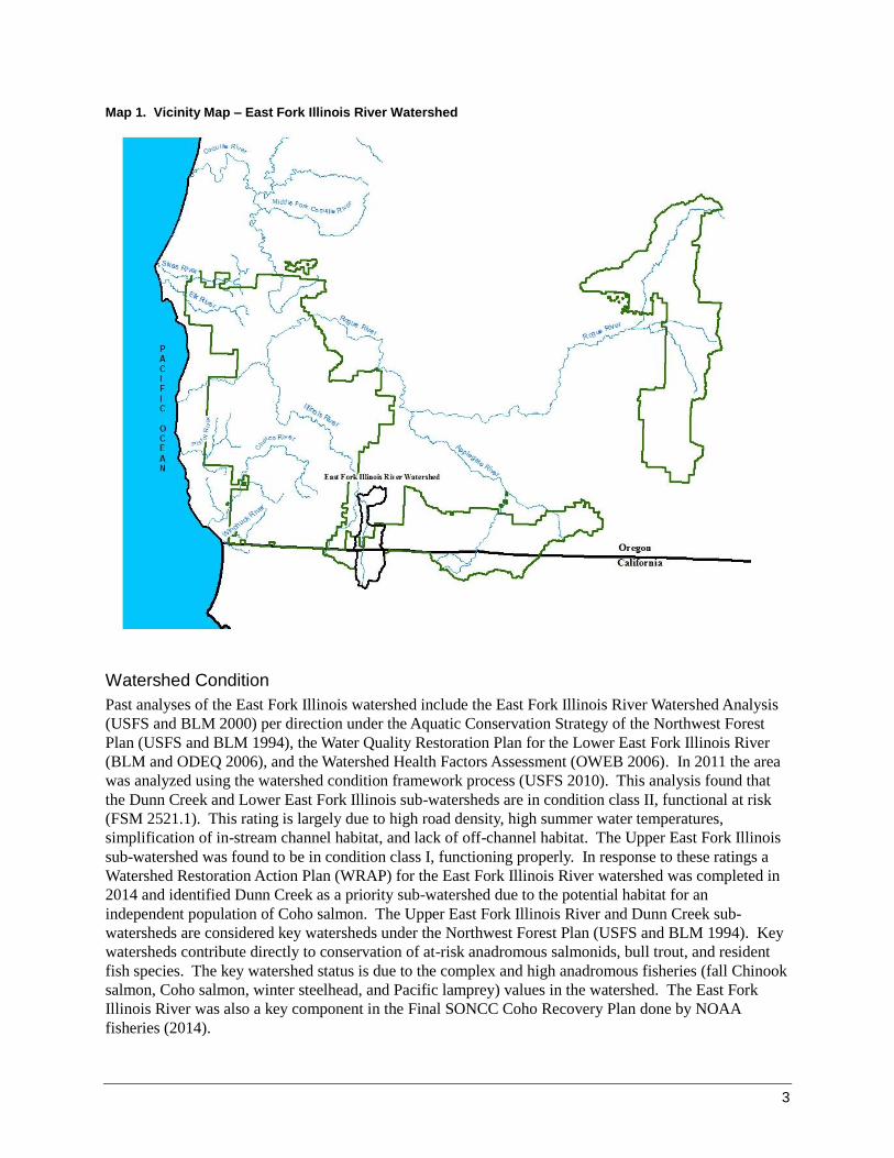
The analysis area for this section is based on the East Fork Illinois River 5th field watershed. The East
Fork Illinois watershed is approximately 57,780 acres within the Illinois River sub-basin within the
Klamath Mountain Geologic Province of southwestern Oregon (Map 1). The East Fork Illinois River
merges with the West Fork Illinois River at the city of Cave Junction, Oregon to form the Illinois River,
which flows into the Rogue River at Agness. The current climate in this watershed is characterized by dry
hot summers and cool wet winters. The rainy season typically runs from October through May,
accounting for 90 percent of the total precipitation. The annual average rainfall varies within the
watershed from approximately 45 inches at lower elevations to 80 inches at higher elevations. Elevation
ranges from 800 feet at the confluence of the East Fork Illinois and West Fork Illinois Rivers to 5,800 feet
at Sanger Peak. The high ridges are snow-covered for several months each winter, but no permanent snow
fields or glaciers are present. The Mediterranean climate and transient snow characteristics of the
watershed generate highly variable seasonal stream flows in East Fork Illinois River. A large portion of
the watershed is within the transitory snow zone at approximately 2,000 to 5,000 feet and snow
alternately falls and melts as temperatures vary from incoming Pacific storms. Floods generally occur
when a warm Pacific storm rapidly melts snow accumulated during November to February.
3
Map 1. Vicinity Map – East Fork Illinois River Watershed
Watershed Condition
Past analyses of the East Fork Illinois watershed include the East Fork Illinois River Watershed Analysis
(USFS and BLM 2000) per direction under the Aquatic Conservation Strategy of the Northwest Forest
Plan (USFS and BLM 1994), the Water Quality Restoration Plan for the Lower East Fork Illinois River
(BLM and ODEQ 2006), and the Watershed Health Factors Assessment (OWEB 2006). In 2011 the area
was analyzed using the watershed condition framework process (USFS 2010). This analysis found that
the Dunn Creek and Lower East Fork Illinois sub-watersheds are in condition class II, functional at risk
(FSM 2521.1). This rating is largely due to high road density, high summer water temperatures,
simplification of in-stream channel habitat, and lack of off-channel habitat. The Upper East Fork Illinois
sub-watershed was found to be in condition class I, functioning properly. In response to these ratings a
Watershed Restoration Action Plan (WRAP) for the East Fork Illinois River watershed was completed in
2014 and identified Dunn Creek as a priority sub-watershed due to the potential habitat for an
independent population of Coho salmon. The Upper East Fork Illinois River and Dunn Creek sub-
watersheds are considered key watersheds under the Northwest Forest Plan (USFS and BLM 1994). Key
watersheds contribute directly to conservation of at-risk anadromous salmonids, bull trout, and resident
fish species. The key watershed status is due to the complex and high anadromous fisheries (fall Chinook
salmon, Coho salmon, winter steelhead, and Pacific lamprey) values in the watershed. The East Fork
Illinois River was also a key component in the Final SONCC Coho Recovery Plan done by NOAA
fisheries (2014).
4
Aquatic resources have been altered by mining, past timber harvest, agriculture and road construction.
These have impacted aquatic habitat through sedimentation, channel modification, removal of large
woody debris, creation of fish passage barriers, and reduction of stream shading from riparian vegetation.
Many channels exhibit disturbance responses such as increased width, elevated water temperature, loss of
pool habitat due to sedimentation or loss of substrate, loss of side channel habitat due to channel
straightening, and loss of channel structure and habitat due to lack of large wood.
Channel Morphology-Stream Characteristics
Streams can be classified into general types by organizing stream feature data into discreet combinations
that typically occur together. The Rosgen classification scheme utilizes stream types based on landscape
morphology and stream reach characteristics (Rosgen 1996). For each stream reach a “most frequent
range” of values is given for morphological descriptions, such as width-depth ratio (Rosgen 1996). The
following descriptions are based on stream surveys and descriptions from the WRAP.
The streams along the mainstem of the East Fork Illinois River and the lower reaches of Dunn Creek are
C channel type (sinuous, low gradient channels, Rosgen 1994). The tributaries and upper reaches are
mostly B (low sinuosity, moderate gradient) and A (low sinuosity, high gradient) channel types. Sediment
and large wood can move quickly during storms from the upper reaches to the C depositional reaches in
the mainstems of Dunn Creek and East Fork Illinois River. Generally, there is a surplus of sediment and
lack of large wood in these areas. The Lower East Fork Illinois River subwatershed contains a wide
alluvial valley that is a primary agricultural use.
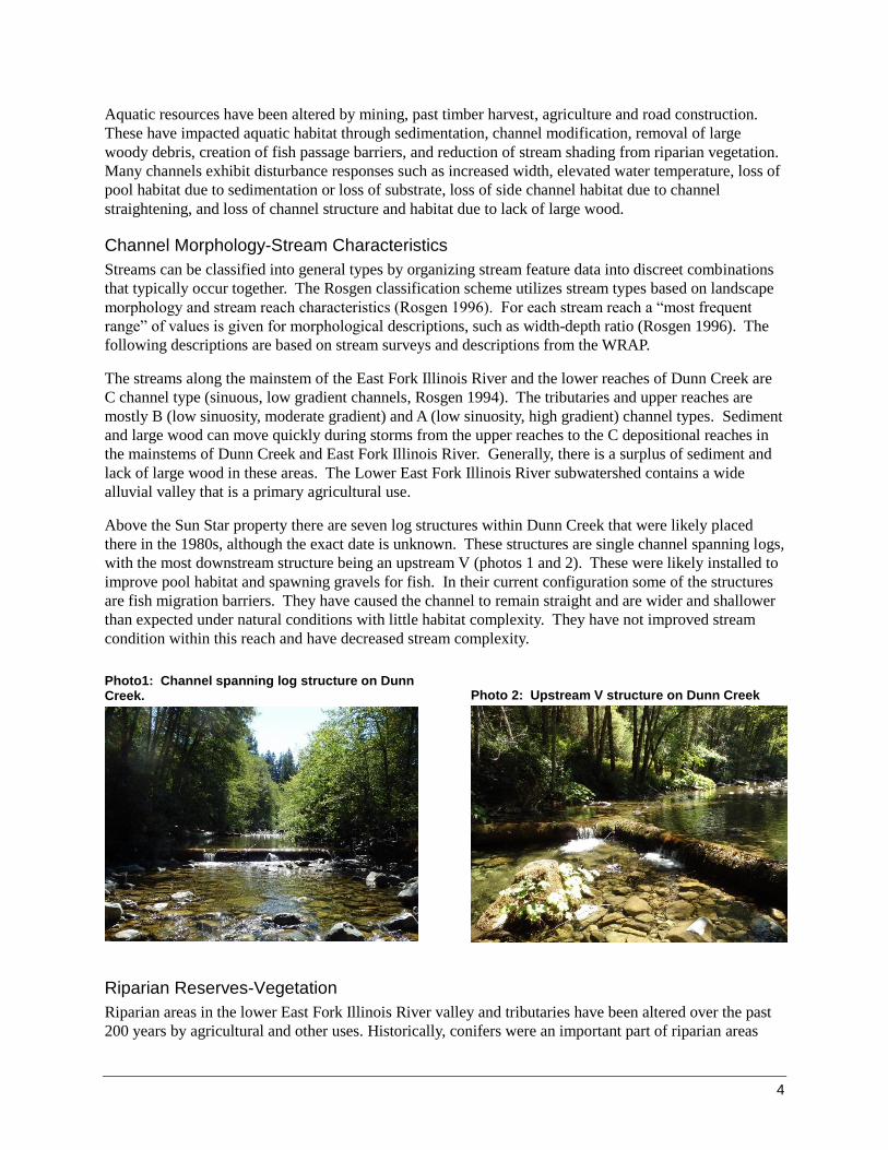
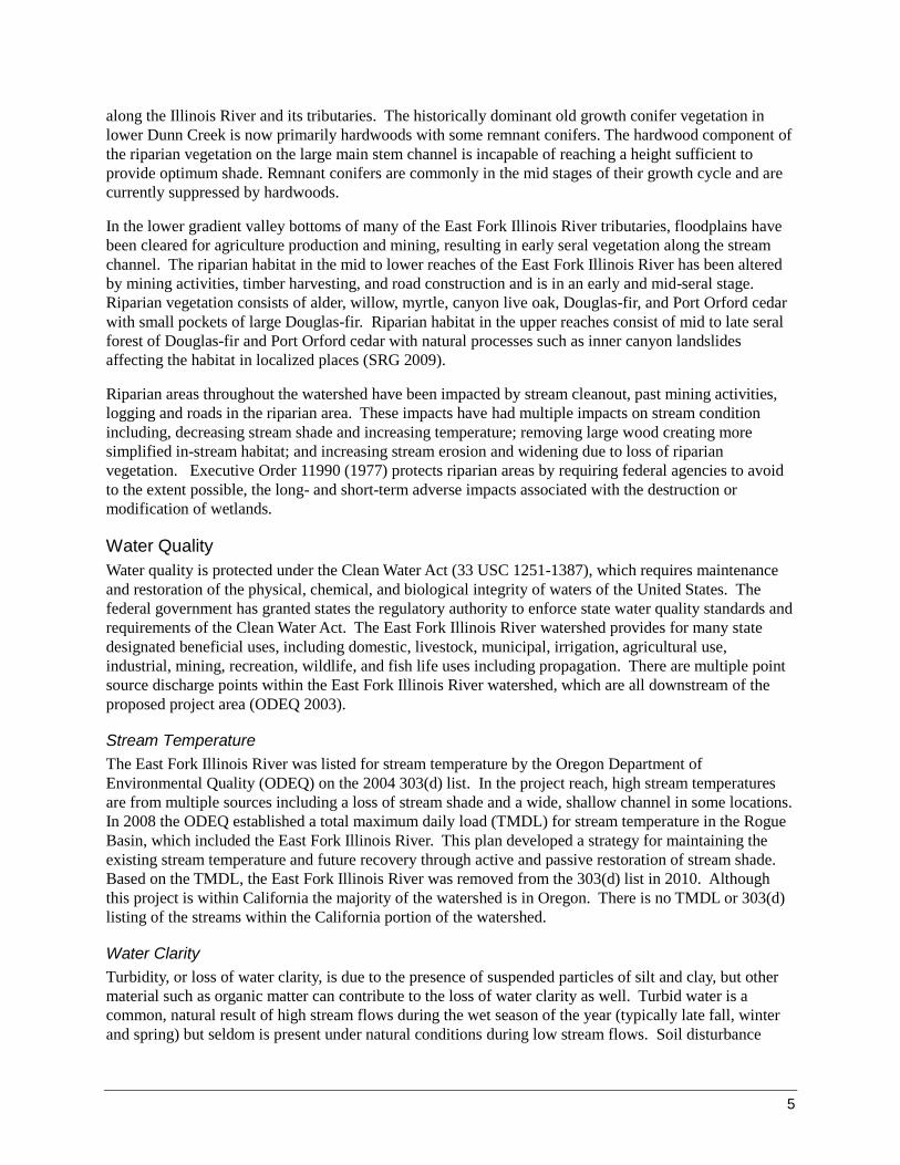
Above the Sun Star property there are seven log structures within Dunn Creek that were likely placed
there in the 1980s, although the exact date is unknown. These structures are single channel spanning logs,
with the most downstream structure being an upstream V (photos 1 and 2). These were likely installed to
improve pool habitat and spawning gravels for fish. In their current configuration some of the structures
are fish migration barriers. They have caused the channel to remain straight and are wider and shallower
than expected under natural conditions with little habitat complexity. They have not improved stream
condition within this reach and have decreased stream complexity.
Photo1: Channel spanning log structure on Dunn Creek.
Photo 2: Upstream V structure on Dunn Creek
Riparian Reserves-Vegetation
Riparian areas in the lower East Fork Illinois River valley and tributaries have been altered over the past
200 years by agricultural and other uses. Historically, conifers were an important part of riparian areas
5
along the Illinois River and its tributaries. The historically dominant old growth conifer vegetation in
lower Dunn Creek is now primarily hardwoods with some remnant conifers. The hardwood component of
the riparian vegetation on the large main stem channel is incapable of reaching a height sufficient to
provide optimum shade. Remnant conifers are commonly in the mid stages of their growth cycle and are
currently suppressed by hardwoods.
In the lower gradient valley bottoms of many of the East Fork Illinois River tributaries, floodplains have
been cleared for agriculture production and mining, resulting in early seral vegetation along the stream
channel. The riparian habitat in the mid to lower reaches of the East Fork Illinois River has been altered
by mining activities, timber harvesting, and road construction and is in an early and mid-seral stage.
Riparian vegetation consists of alder, willow, myrtle, canyon live oak, Douglas-fir, and Port Orford cedar
with small pockets of large Douglas-fir. Riparian habitat in the upper reaches consist of mid to late seral
forest of Douglas-fir and Port Orford cedar with natural processes such as inner canyon landslides
affecting the habitat in localized places (SRG 2009).
Riparian areas throughout the watershed have been impacted by stream cleanout, past mining activities,
logging and roads in the riparian area. These impacts have had multiple impacts on stream condition
including, decreasing stream shade and increasing temperature; removing large wood creating more
simplified in-stream habitat; and increasing stream erosion and widening due to loss of riparian
vegetation. Executive Order 11990 (1977) protects riparian areas by requiring federal agencies to avoid
to the extent possible, the long- and short-term adverse impacts associated with the destruction or
modification of wetlands.
Water Quality
Water quality is protected under the Clean Water Act (33 USC 1251-1387), which requires maintenance
and restoration of the physical, chemical, and biological integrity of waters of the United States. The
federal government has granted states the regulatory authority to enforce state water quality standards and
requirements of the Clean Water Act. The East Fork Illinois River watershed provides for many state
designated beneficial uses, including domestic, livestock, municipal, irrigation, agricultural use,
industrial, mining, recreation, wildlife, and fish life uses including propagation. There are multiple point
source discharge points within the East Fork Illinois River watershed, which are all downstream of the
proposed project area (ODEQ 2003).
Stream Temperature
The East Fork Illinois River was listed for stream temperature by the Oregon Department of
Environmental Quality (ODEQ) on the 2004 303(d) list. In the project reach, high stream temperatures
are from multiple sources including a loss of stream shade and a wide, shallow channel in some locations.
In 2008 the ODEQ established a total maximum daily load (TMDL) for stream temperature in the Rogue
Basin, which included the East Fork Illinois River. This plan developed a strategy for maintaining the
existing stream temperature and future recovery through active and passive restoration of stream shade.
Based on the TMDL, the East Fork Illinois River was removed from the 303(d) list in 2010. Although
this project is within California the majority of the watershed is in Oregon. There is no TMDL or 303(d)
listing of the streams within the California portion of the watershed.
Water Clarity
Turbidity, or loss of water clarity, is due to the presence of suspended particles of silt and clay, but other
material such as organic matter can contribute to the loss of water clarity as well. Turbid water is a
common, natural result of high stream flows during the wet season of the year (typically late fall, winter
and spring) but seldom is present under natural conditions during low stream flows. Soil disturbance
6
from management activities can cause sediment to be delivered to a stream. Sediment delivered to a
stream most often is comprised of both suspended sediment (silt and clay) and courser materials (sand and
gravel) that are transported as bedload. Most suspended sediments that affect water clarity are transported
through the stream system during flood flows. There is no monitoring data available for turbidity in the
East Fork Illinois project area.
Hazardous Materials
There are no records of sites where hazardous materials would be entering streams within the project area.
Suction dredging in California has been prohibited by statute since August 6, 2009 (Fish and Game Code
5653.1 subd. (b)), so this is not a concern in this area. On lands downstream within Oregon it is possible
that suction dredging could occur. On lands managed by the Forest Service, mitigation measures are
required which minimize risk of chemical spills during equipment use.
III. Environmental Consequences
Alternative 1 (No-Action)
Direct and Indirect Effects
Under this alternative the existing condition would remain the same. No large woody debris would be
added to the stream system, no side channel construction would occur, and no riparian planting would be
done.
Channel Morphology-Stream Characteristics
The no action alternative would have no effect on channel morphology, since no active restoration
activities would occur. Natural alterations in channel morphology and processes would continue to occur.
This alternative would allow for natural recovery for stream stabilization, revegetation of stream banks
and the floodplain, and fisheries habitat creation over time. Natural recovery is estimated to take up to
100 years due to the effects of past management activities. The structures that are currently in Dunn
Creek would remain in their current condition and continue to influence the stream channel shape and
complexity within this reach. Stream width would remain high which raises stream temperature. The
stream would remain straighter than expected increasing stream power and erosive forces along the
streambanks.
Riparian Reserves-Vegetation
There would be no removal of vegetation in riparian reserves under this alternative. The composition and
character of the site would remain unchanged and natural processes would continue to occur. A lack of
conifer species would remain in some portions of the watershed.
Watershed Condition
Watershed condition would not be improved in the Dunn Creek sub-watershed. The resource concerns
associated with the lack of large wood, spawning habitat, and off-channel habitat described in the WRAP
would not be addressed (USFS 2014). The Dunn Creek sub-watershed would remain functional at risk.
Water Quality
Stream Temperature
The no action alternative would have no effect on stream temperature since there would be no restoration
activities. The composition and character of riparian and forest stands affecting temperature would not be
7
altered. Channel width would not be reduced and channel depth would not increase. It is likely that
temperature would improve over time, however with the current lack of conifer species in the lower
portion of the riparian area, this would occur at a much slower rate than under the proposed action. There
would be little reduction in stream temperature from the riparian forest and the East Fork Illinois River
would not be working toward the TMDL for temperature.
Water Clarity
There would be no increase in sediment or turbidity in streams in the project area. Naturally occurring
sediment delivery would continue to occur, however no increased impacts are expected.
Alternative 2 (Proposed Action)
Direct and Indirect Effects
Channel Morphology-Stream Characteristics
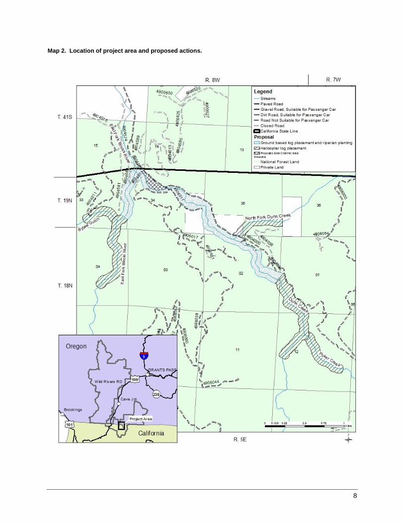
Under Alternative 2 one or more side channels would be built off of the Dunn Creek mainstem below the
NFSR 490600 road-stream crossing. The side channel location would be determined using hydrologic
modelling and on the ground surveys to ensure the channels fill at the appropriate mainstem flow, and that
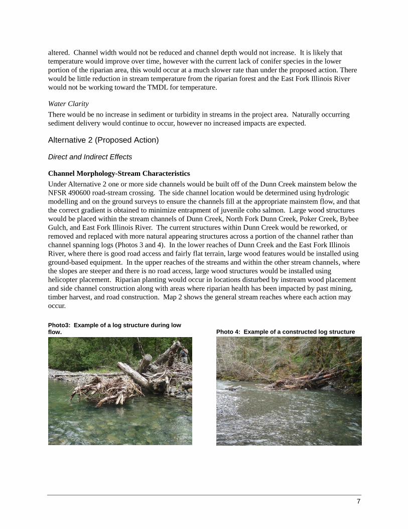
the correct gradient is obtained to minimize entrapment of juvenile coho salmon. Large wood structures
would be placed within the stream channels of Dunn Creek, North Fork Dunn Creek, Poker Creek, Bybee
Gulch, and East Fork Illinois River. The current structures within Dunn Creek would be reworked, or
removed and replaced with more natural appearing structures across a portion of the channel rather than
channel spanning logs (Photos 3 and 4). In the lower reaches of Dunn Creek and the East Fork Illinois
River, where there is good road access and fairly flat terrain, large wood features would be installed using
ground-based equipment. In the upper reaches of the streams and within the other stream channels, where
the slopes are steeper and there is no road access, large wood structures would be installed using
helicopter placement. Riparian planting would occur in locations disturbed by instream wood placement
and side channel construction along with areas where riparian health has been impacted by past mining,
timber harvest, and road construction. Map 2 shows the general stream reaches where each action may
occur.
Photo3: Example of a log structure during low flow.
Photo 4: Example of a constructed log structure
8
Map 2. Location of project area and proposed actions.
9
Riparian planting would provide several beneficial effects in the short-term (three to ten years) and long-
term (60 years to conifer maturation). As vegetation becomes established, trees, shrubs, and other plants
would assist in providing streambank stability. Established vegetation would also aid in providing
roughness across the floodplain to capture sediment and reduce water velocities during high flow events.
In addition, as planted conifers in the riparian area mature, large wood levels would be restored and
available for recruitment into the stream channel. There would be a number of beneficial effects from this
wood naturally falling into the stream channel and on the floodplain over time.
Construction and reconstruction of large wood structures in the streams would allow for the retention of
spawning gravels and woody debris within the channel. The addition of large wood would also increase
channel complexity, protect streambanks, and aid in the regulation of sediment in the system. Large wood
structures would provide roughness elements that would help regulate bed load movement of the stream
channel and fine sediment deposition in the floodplain through time. The structures would assist in the
regulation of water velocity and volume in the new side channels. Therefore, large wood structures
would have a beneficial effect on channel morphology. Side channel construction would provide
additional benefits to channel function and habitat, increasing floodplain connectivity and channel
complexity in that area. The side channels would be built with habitat features such as pools and riffles.
Smaller wood pieces would be included in the design to improve overstory cover and stream complexity.
Although there are risks associated with construction of the large wood structures (e.g. erosion of the
opposite bank associated with the structures) and overflow channels (e.g. movement of most of Dunn
Creek into the constructed channel and out of the current channel) assessments completed during the
design phase of this project would measurably reduce the potential risk. Actions considered to reduce the
risk of log displacement include interconnecting multiple logs, burying logs into the streambanks, placing
structures to extend above the 100-year flood elevation, and weaving structures into existing vegetation
when using helicopter placement.
Riparian Reserves-Vegetation
Placement of large wood structures would remove some stream side vegetative cover as trenches for large
wood pieces are dug into the streambank. Locations of structures would be determined to minimize the
loss of trees and shrubs. Any shrubs or small trees removed would be used on-site for slash in structures
or as cover for newly disturbed areas. Building of the side channels would also remove vegetation;
however, it is likely that these channels will be far enough from the mainstem that streamshade would not
be affected except at the points where they meet the mainstem of Dunn Creek. Areas disturbed during
construction would be planted with a mix of trees and shrubs following construction, and would follow
guidelines outlined in the revegetation plan. Although there would be some effects to vegetation in the
riparian area, adverse impacts would be short term and are expected to be minimal.
Planting a mix of native species would have a positive effect in riparian reserves, particularly the resistant
POC which should allow for re-establishment of this native species in the project area. Ultimately, some
of these resistant POC should survive and contribute to long lasting decay resistant in-channel structure to
the project area. A riparian plant community would be established in the riparian area and across the
floodplain. Areas that were previously impacted from past management activities would be revegetated.
The conifers that are currently lacking in some portions of the project area would be re-established.
Watershed Condition
Watershed condition would be improved by increasing channel complexity through the addition of large
wood structures and off-channel habitat, and improving riparian plant diversity though riparian planting.
Watershed condition in Dunn Creek which is currently functioning at risk would move toward and
possibly attain proper functioning condition.
10
Water Quality
Stream Temperature
Placement of large wood structures would not have any direct negative effects on stream temperature.
Large wood structures could provide some level of reduced temperatures at the microsite scale, but this
effect would not be measurable throughout the project reach.
As planted trees reach maturity (60 years), stream shading would increase in areas of the project that are
currently not well shaded. This increase in stream shading would contribute to reducing stream
temperature through the project area in the long-term.
Water Clarity
Short-term small pulses of turbidity would occur when large wood structures are constructed in the stream
channel using ground-based equipment and during construction of the side channels. Since structures
would be buried into the streambanks there would be some sediment inputs to the stream channel.
Turbidity pulses caused by these activities would quickly decrease to background levels after equipment
work stops. In addition, large wood structures would be placed during low flow to minimize effects to
water quality from sediment and turbidity. Turbidity increases from the side channel are likely to occur
during the first flow event through these newly constructed areas, but would return to background levels
during subsequent flow events. As planted vegetation becomes established in the riparian reserve, bank
stability would be provided, aiding in the prevention of excessive erosion and associated fine sediment
inputs to the stream. Large wood structures placed using helicopters would not have any measurable
effect on water clarity since these structures would be woven into existing trees and would not be buried
into the streambank.
Cumulative Effects
Past management activities from mining, logging, and roads have impacted stream function and water
quality in the East Fork Illinois River watershed. Future activities that could occur within the East Fork
Illinois River watershed include road decommissioning and timber harvest. Both of these activities would
require NEPA decisions and would not occur for many years. On private lands downstream of the project
area effects of agriculture, irrigation, and developments within the floodplain are more prevalent and will
continue to impact watershed condition. Effects of these activities include high stream temperatures,
increased fine sediment inputs, and a decrease in conifer species in some areas. Currently, both the Dunn
Creek and Lower East Fork sub-watersheds are considered functional-at-risk due to past disturbance.
This alternative would reduce adverse cumulative effects by improving stream function and riparian plant
diversity. The proposed treatments would help reduce the cumulative effects of past mining and timber
harvest, by improving the amount of large wood in stream channels, increasing off-channel habitat, and
increasing conifer species in riparian areas currently deficient in these species. Future timber harvest
would not use historic techniques and would rather be used to improve vegetative health of the stands,
which would also improve watershed health. These actions as well as future road decommissioning
would help to move the sub-watersheds toward proper functioning condition.
IV. Compliance with Aquatic Conservation Strategy An integral part of the Northwest Forest Plan is the Aquatic Conservation Strategy (ACS). The ACS is
intended to maintain and restore the ecological health of the watersheds and ecosystems within the
Northwest Forest Plan area. On March 30, 2007, the District Court, Western District of Washington,
ruled adverse to the US Fish and Wildlife Service (USFWS), National Oceanic and Atmospheric
Administration (NOAA-Fisheries) and USFS and BLM (Agencies) in Pacific Coast Fed. of Fishermen’s
Assn. et al. v. Natl. Marine Fisheries Service, et al. and American Forest Resource Council, Civ. No. 04-
11
1299RSM (W.D. Wash)( (PCFFA IV). Based on violations of the Endangered Species Act (ESA) and the
National Environmental Policy Act (NEPA), the Court set aside the USFWS Biological Opinion (March
18, 2004), the NOAA-Fisheries Biological Opinion for the ACS Amendment (March 19, 2004), the ACS
Amendment Final Supplemental Environmental Impact Statement (FSEIS) (October 2003), and the ACS
Amendment adopted by the Record of Decision dated March 22, 2004.
As a result of PCFFA IV, the Forest Service must now assess project consistency with the nine ACS
objectives as was done prior to the 2004 Record of Decision for the ACS amendment. New project
NEPA decisions must be consistent with the wording regarding ACS consistency, including consistency
with the nine ACS objectives, as ACS consistency is described in the 1994 NWFP ROD on page B-10. In
making the ACS consistency finding and to be guided by PCFFA IV, the decision maker must:
Review projects against the ACS objectives at the project or site scale, rather than only at the
watershed scale. This review can be accomplished through cumulative effects analyses (e.g., by
evaluating the incremental effect of the project added to the existing condition, and the effects of
other present and reasonably foreseeable future actions) on watershed conditions.
Evaluate the immediate (short-term) impacts, as well as long-term impacts of an action.
Provide a description of the existing watershed condition, including the important physical and
biological components of the 5th field watershed.
Provide written evidence that the decision maker considered relevant findings of watershed analysis.
The Northwest Forest Plan requires consistency with ACS with specific reference to nine ACS
Objectives. Below, is a summation of the environmental analysis regarding consistency with the elements
and components of the Objectives. Specific rationale may be found in other analysis documented under
other resources, e.g., Soils, Fisheries, Wildlife, Botany, etc.
Aquatic Conservation Strategy Objectives
This section focuses on the attainment of the nine Aquatic Conservation Strategy Objectives of the
alternatives considered in detail, the response to the specific Standards and Guidelines associated with
Riparian Reserves (NWFP C-33 & 34), and the attainment of Standards and Guidelines associated with
Key Watersheds (NWFP B-19).
Complying with the Aquatic Conservation Strategy objectives means that an agency must manage the
riparian-dependent resources to maintain the existing condition or implement actions to restore
conditions. The baseline from which to assess maintaining or restoring the condition is developed
through a Watershed Analysis. Improvement relates to restoring biological and physical processes within
their ranges of natural variability.
The Standards and Guidelines are designed to focus the review of proposed and certain existing projects
to determine compatibility with the Aquatic Conservation Strategy objectives. The Standards and
Guidelines focus on "meeting" and "not preventing attainment" of Aquatic Conservation Strategy
objectives. The intent is to ensure that a decision maker must find that the proposed management activity
is consistent with the Aquatic Conservation Strategy objectives. The decision maker will use the results of
watershed analysis to support the finding.
In order to make the finding that a project or management action "meets" or "does not prevent attainment"
of the Aquatic Conservation Strategy objectives, the analysis must include a description of the existing
condition, a description of the range of natural variability of the important physical and biological
components of a given watershed, and how the proposed project or management action maintains the
existing condition or moves it within the range of natural variability.
12
Below is a summation of the environmental analysis regarding consistency with the elements and
components of the objectives. Specific rationale may be found in other analysis documented under other
resources, e.g., Soils, Fisheries, Wildlife, Botany, etc.
ACS Objective 1. Maintain and restore the distribution, diversity, and complexity of watershed and
landscape-scale features to ensure protection of the aquatic systems to which species, populations and
communities are uniquely adapted.
Alternative 1 would maintain the current landscape-scape features within the watershed. The aquatic
system and riparian reserves would not be improved. The simplified stream structure would remain due
to a lack of large wood within the stream channel and a deficiency in the availability of large wood in the
riparian area. The creation of off-stream habitat would not improve channel complexity. The riparian
forest would remain deficient in conifer species in many areas throughout the watershed. This alternative
meets the objective.
Alternative 2 would restore the distribution, diversity, and complexity of watershed and landscape-scale
features to ensure protection of the aquatic systems to which species, populations, and communities are
uniquely adapted. Construction of one or more side channels, placement of large wood structures, and
improvement of riparian vegetation would restore the distribution, diversity, and complexity of aquatic
and riparian systems. Off-channel habitat would be created and stream complexity would be improved.
Off-channel habitat was found to be a limiting factor in the SONCC recovery plan (NOAA 2014), and this
project would improve that condition. Planting areas with a mix of native trees and shrubs would restore
the plant communities in the riparian area and floodplain. The distribution, diversity, and complexity of
these plant communities would improve as open areas that were previously impacted from past
management activities would be improved. In addition, the conifers that are lacking in some portions of
the project would be reestablished. These projects meet the objectives defined in the Watershed
Restoration Action Plan to improve watershed condition in the East Fork Illinois River watershed (USDA
2014). This alternative meets the objective.
ACS Objective 2. Maintain and restore spatial and temporal connectivity within and between
watersheds. Lateral, longitudinal, and drainage network connections include floodplains, wetlands,
upslope areas, headwater tributaries, and intact refugia. These network connections must provide
chemically and physically unobstructed routes to areas critical for fulfilling life history requirements of
aquatic and riparian-dependent species.
Alternative 1 would maintain the current condition and maintain existing connectivity throughout the
watershed. No activities in Alternative 2 would sever existing linkages between watersheds or
permanently obstruct existing connections in the drainage network. While some existing vegetation will
be removed inside the project area, the relatively small size of these sites would not hinder dispersal of
flora, fauna, and water across the terrestrial landscape. None of the activities proposed will chemically or
physically impede routes to areas critical for fulfilling life history requirements of aquatic and riparian-
dependent species, especially the threatened coho salmon. Both alternatives meet the objective.
ACS Objective 3. Maintain and restore the physical integrity of the aquatic system, including
shorelines, banks, and bottom configurations.
Alternative 1 would not affect the physical integrity of the system. However, under the current condition
many streams within the watershed are wider and deeper than would be expected based on their location
in the environment. This was caused by past management actions that removed large wood and
straightened stream channels removing the vegetative cover that was present and increasing the erosion
potential along streambanks. This alternative meets the objective.
13
Alternative 2 would improve the physical integrity of the aquatic system. Banks would be stabilized and
a larger portion of the floodplain would be connected to the stream channel. Large wood structures and
riparian planting would aid in the protection of streambanks, as well as provide roughness elements to
reduce water velocities and shear stress on streambanks. As vegetation becomes established, the roots of
these plants would provide increased streambank stability. This alternative meets restoration objectives
identified in the Watershed Restoration Action Plan for the East Fork Illinois River watershed (USDA
2014). This alternative meets the objective.
ACS Objective 4. Maintain and restore water quality necessary to support healthy riparian, aquatic,
and wetland ecosystems. Water quality must remain within the range that maintains the biological,
physical, and chemical integrity of the system and benefits survival, growth, reproduction, and
migration of individuals composing aquatic and riparian communities.
Alternative 1 would maintain the current condition of the ecosystem, which is not meeting water quality
standards for temperature. There is a lack of large conifer species present currently; however, over the
long-term the riparian area will recover as the impacts of past timber harvest and mining improves. This
is not consistent with the TMDL for the East Fork Illinois River and would not improve stream
temperature. This alternative does not meet the objective.
Alternative 2 would maintain and restore water quality conditions to support healthy riparian and aquatic
ecosystems. Implementation of the proposed action would result in an increase in stream shade, and may
decrease stream width in the long-term, which would lead to a decrease in stream temperature. The
decrease in water temperature may translate into lower stream temperatures downstream. However, with
the large amount of agricultural land in the Lower East Fork sub-watershed, the benefits to stream
temperature in the upper reaches may not significantly impact lower stream temperatures. The project
would have a beneficial effect on stream temperature within the Dunn Creek and Upper East Fork sub-
watersheds, improving water quality for aquatic and riparian communities within these areas.
Implementation of the project would cause some short-term turbidity plumes and pulses from
construction of the off-channel habitat and placement of large wood structures. These increases in
turbidity would be minimized by constructing the channel during low flow conditions. Further, all work
would be performed within the California Department of Fish and Wildlife instream work window (June
15 to November 1) to minimize effects to fish. Water quality conditions would be within the range
needed to maintain the integrity of the system. This alternative follows direction in the TMDL for the
East Fork Illinois River and meets the objective.
ACS Objective 5. Maintain and restore the sediment regime under which aquatic ecosystems evolved.
Elements of the sediment regime include the timing, volume, rate, and character of sediment input,
storage, and transport.
Alternative 1 would maintain the current sediment regime. Under this alternative no new habitat features
would be created and spawning gravels would continue to move through the system and be a limiting
factor within the watershed. This alternative does not meet the objective.
Alternative 2 would maintain and possibly improve the sediment regime by using large wood to create
features to hold spawning gravels, which are currently a limiting factor in the watershed according to the
WRAP (USDA 2014). This would improve overall habitat and restore elements of the stream channel
that are currently lacking and would implement projects identified for improving watershed condition and
the sediment regime identified in the WRAP. This alternative meets the objective.
14
ACS Objective 6. Maintain and restore in-stream flows sufficient to create and sustain riparian,
aquatic, and wetland habitats and to retain patterns of sediment, nutrient, and wood routing. The
timing, magnitude, duration, and spatial distribution of peak, high, and low flows must be protected.
None of the alternatives would have a measurable effect on stream flow.
ACS Objective 7. Maintain and restore the timing, variability, and duration of floodplain inundation
and water table elevation in meadows and wetlands.
Alternative 1 would maintain the current condition. Alternative 2 would improve the timing, variability,
and duration of floodplain inundation where the off-channel habitat is created. Floodplain connectivity
would be improved and normal high flows would have access to the floodplain. Both alternatives meet
the objective.
ACS Objective 8. Maintain and restore the species composition and structural diversity of plant
communities in Riparian Reserves and wetlands to provide adequate summer and winter thermal
regulation, nutrient filtering, appropriate rates of surface erosion, bank erosion, and channel
migration and to supply amounts and distributions of coarse woody debris sufficient to sustain physical
complexity and stability.
Alternative 1 would maintain the current condition, which is lacking in large conifer species and does not
provide adequate thermal regulation or coarse woody debris to the stream system. This is not consistent
the TMDL for the East Fork Illinois watershed and would not move toward a healthier watershed
condition. This alternative does not meet the objective.
Alternative 2 would improve species composition and structural diversity of plant communities within the
riparian reserve. Although there would be some removal of vegetation associated with off-channel
construction and large wood placement, these disturbed areas would be replanted with a mix of native
trees and shrubs following construction. Revegetation would occur with conifers, including disease
resistant Port-Orford-cedar, hardwoods, and a variety of shrubs. By using a species mix of trees and
plants that are appropriate to the site, the species compostion and structural diversity of plant communities
in riparian reserves would be maintained in the short-term and improved in the long-term. Existing and
planted vegetation would provide adequate thermal regulation, nutrient filtering, and appropriate rates of
surface erosion, bank erosion, and channel migration. In the long-term planted trees would restore the
amount and distribution of coarse woody debris that is currently not present in some locations. This
alternative follows direction in the TMDL for the East Fork Illinois River and meets the objective.
ACS Objective 9. Maintain and restore habitat to support well-distributed populations of native plant,
invertebrate, and vertebrate riparian-dependent species.
Alternative 1 would maintain the current condition and species populations would remain stable.
Alternative 2 would maintain and restore habitat to support well-distributed populations of native plant,
invertebrate, and vertebrate riparian-dependent species. By improving some floodplain connectivity,
habitat for riparian-dependent species would increase or be maintained. Flood flows would deliver
nutrients to the riparian area which would allow for improved growth of riparian vegetation. In addition,
native species would be planted to support invertebrate and vertebrate-dependent species. By establishing
a more robust riparian gallery forest, a diverse variety of habitats for a mix of species would be created.
Both alternatives would meet the objective.
Alternative 1 does not meet the Aquatic Conservation Strategy
15
Alternative 2 meets the Aquatic Conservation Strategy
V. Summary
The proposed action improves upon the current condition of the East Fork Illinois watershed and
specifically addresses needs identified in the Watershed Restoration Action Plan (USFS 2014) to improve
watershed condition. The plans, assessments, and analyses that were already in place were incorporated
into the WRAP to determine limiting factors and the priority for projects. The projects were ranked as
high, medium, and low priority and are being implemented based on this ranking. Most of the high
priority projects were identified on private land within the Lower East Fork sub-watershed. Working with
the Illinois Valley Watershed Council these projects may occur in the future.
This analysis indicates that Alternative 1 would not be in compliance with the ACS listed in the
Northwest Forest Plan. It would not be working toward the TMDL for temperature and water quality
would continue to be impaired. Past impacts from timber harvest, mining, and road construction would
persist. Due to these past actions and current condition many channels exhibit disturbance responses such
as increased width, elevated water temperature, loss of pool habitat due to sedimentation or loss of
substrate, loss of side channel habitat due to channel straightening, and loss of channel structure and
habitat due to lack of large wood. Impacts to aquatic habitat through sedimentation, channel
modification, removal of large woody debris, and reduction of stream shading from riparian vegetation
would continue and may be improved through passive recovery in the long-term.
The condition class of the watersheds would not improve in the priority or key watersheds. No
improvements would be made to critical off-channel habitat.
Alternative 2 would be in compliance with the ACS and would have long term benefits to the function of
the stream channel, riparian area, and associated floodplain. The proposed action is the first step in
moving towards an improved watershed condition as outlined in the WRAP. There would be an increase
in off-channel habitat through the creation of the side channels. This would provide critical slow water
habitat for juvenile coho salmon during high flow events. The side channel would also provide for
improved floodplain connectivity in this area.
The addition of large woody debris to the stream system would improve channel habitat and function and
increase stream complexity. The structures would help regulate bed load movement of the stream channel
and fine sediment deposition in the floodplain through time. Large wood structures would have a
beneficial effect on channel morphology. During construction of the large wood structures there would be
a short-term increase in turbidity which would quickly decrease after equipment work stops. The long-
term benefit of these structures outweighs the short-term impacts during construction.
Riparian planting would provide several beneficial effects. A diverse riparian plant community would be
established in riparian areas. As vegetation becomes established, trees, shrubs, and other plants would
assist in providing streambank stability. Established vegetation would also aid in providing roughness
across the floodplain to capture sediment and reduce water velocities during high flow events. In
addition, as planted conifers in the riparian area mature, large wood levels would be restored and
available for recruitment into the stream channel.
Alternative 2 would improve watershed condition by increasing channel complexity through the addition
of large wood structures and off-channel habitat, and improving riparian plant diversity though riparian
planting. Watershed condition in Dunn Creek which is currently functioning at risk would move toward
and possibly attain proper functioning condition.
16
VI. Hydrology Mitigation Measures
Minimize the number and length of access points through riparian areas.
Heavy equipment will be cleaned and free of leaks before use within the stream channel.
Develop and implement an approved spill containment plan that includes having a spill
containment kit on-site.
Refuel equipment, including chainsaws, and other hand power tools, at least 150 feet from water
bodies to prevent direct delivery of contaminants into a water body (or as far as possible from the
water body where local site conditions do not allow a 150-foot setback).
Construct new side channel segment(s) and log complexes built with ground based equipment
during dry conditions.
All in-channel stream work would occur during the California Department of Fish and Wildlife
instream construction timing window (June 15 to November 1) to minimize impacts to salmon.
In compliance with the California Fish and Wildlife guidance all relevant mitigation measures
would be followed (Carpia and Mandrup 2015).
17
Literature Cited
(BLM and ODEQ) United States Department of Interior, Bureau of Land Management and Oregon
Department of Environmental Quality. 2006. Water Quality Restoration Plan, Lower East Fork
Illinois River. Bureau of Land Management, Medford District, Medford, Oregon.
Carpio, K. and M. Mandrup. 2015. California Department of Fish and Wildlife Mitigated Negative
Declaration for the 2015 Fisheries Restoration Grant Program in Del Norte, Humbolt, Marin,
Mendicino, Monterey, Napa, San Luis, Obispo, San Mateo, Santa Barbara, Santa Clara, Santa
Cruz, Siskiyou, Sonoma, Trinity, and Ventura Counties, and Required Agreement Regarding
Stream or Lake Alteration. State of California Resource Agency, Department of Fish and
Wildlife, Fisheries Branch. Sacramento, California. Available online at:
https://www.dfg.ca.gov/fish/Administration/Grants/FRGP/Mit-Neg-Dec.asp
Executive Order 11900. Protection of Wetlands. May 24, 1977
F.S.M. 2521. Watershed and Air Management: Watershed Condition Assessment. May 26, 2004
(NOAA) National Oceanic and Atmospheric Administration. 2014. Final SONCC Coho Recovery Plan
NOAA National Marine Fisheries Service, Southwest Regional Office, Arcata, California.
(ODEQ) Oregon Department of Environmental Quality. 2003. Source Water Assessment Report for the
City of Cave Junction. Department of Environmental Quality Headquarters, Portland, Oregon.
(ODEQ) Oregon Department of Environmental Quality. 2008. Rogue River Basin TMDL. Department
of Environmental Quality Headquarters, Portland, Oregon.
(ODEQ) Oregon Department of Environmental Quality. 2012. Oregon’s 2012 Integrated Report.
Available online at: http://www.deq.state.or.us/wq/assessment/rpt2012/search.asp
OWEB Oregon Watershed Enhancement Board. 2006. Watershed Health Factors Assessment. Rogue
Basin Coordinating Council, Medford, Oregon.
Rosgen, D.L. 1994: A classification of natural rivers. Catena 22(3): 169-199.
Rosgen, D.L. 1996. Applied River Morphology. Wildland Hydrology. Pagosa Springs, Colorado.
(SRG) Siskiyou Research Group. 2009. East Fork Illinois River Level II Stream Survey. Siskiyou
Research Group. Cave Junction, Oregon.
(USFS and BLM) United States Department of Agriculture, Forest Service, and United States Department
of the Interior, Bureau of Land Management. 1994. Record of Decision for Amendments to Forest
Service and Bureau of Land Management Planning Documents Within the Range of the Northern
Spotted Owl. USDA Forest Service, Pacific Northwest Region, Portland, Oregon. Available
online at: http://www.reo.gov/library/reports/newroda.pdf
(USFS and BLM) United States Department of Agriculture, Forest Service, and United States Department
of the Interior, Bureau of Land Management. 2000. East Fork Illinois River Watershed Analysis.
Bureau of Land Management, Grants Pass Field Office, US Forest Service, Wild Rivers Ranger
District, Cave Junction, Oregon.
(USFS) United States Department of Agriculture, Forest Service. 2010. Watershed Condition
Classification Technical Guide. Primary Authors J. P. Potyondy and T.W. Geier. 70 pp.
18
(USFS) United States Department of Agriculture, Forest Service. 2014. East Fork Illinois River
Watershed Restoration Action Plan. USDA Forest Service, Pacific Northwest Region, Rogue
River-Siskiyou National Forest, Medford, Oregon.