Embed Size (px)
Citation preview

Te AraPātaka
Banks Peninsula
(Summit Walkway)
Published by: Department of ConservationMahaanui/Sockburn officePO Box 11089Sockburn 8443, ChristchurchNew Zealand November 2016
Editing and design:Publishing Team, DOC National Office
Text and images (unless otherwise credited): Rod Donald Banks Peninsula Trust R
1017
31
Cover: Remnant tōtara make the distinctive landscape of Waipuna Saddle. Photo: Andrew Smythe
This publication is produced using paper sourced from well-managed, renewable and legally logged forests.
Public transport Catch public bus #28 from central Christchurch to Lyttelton, and then the ferry to Diamond Harbour. Bus and ferry timetables are available on www.metroinfo.co.nz.Akaroa Shuttle and Akaroa French Connection provide services between Christchurch and Akaroa, and can stop or pick up at Hilltop Tavern on request. If you book to catch the bus at the end of your walk at Hilltop, make sure you let them know to call at the Tavern. Be there 15 min after the bus departure time from Akaroa.• For Akaroa Shuttle book via www.akaroashuttle.co.nz or
ring 0800 500 929. • For Akaroa French Connection book via
www.akaroabus.co.nz or ring 0800 800 575.It is an excellent 2-day trip using public transport starting at Diamond Harbour jetty, staying overnight at Rod Donald Hut, and catching a shuttle from Hilltop Tavern back to Christchurch.
Further information• Contact DOC Christchurch Visitor Centre for all enquiries
about Te Ara Pātaka.• See the Rod Donald Banks Peninsula Trust website for
more information about the Trust. www.roddonaldtrust.co.nz
• Visit www.bpwalks.co.nz for information on all Banks Peninsula walks.
Hut fees per night
Make sure you display proof of your booking next to your bunks. Camping is permitted only by Sign of the Packhorse Hut. You need to pre-purchase camping tickets – there is a marked container next to the hut for the ticket stubs. There is no pre-booking for camping (it’s ‘first in, best served’).
Mountain biking on Te Ara PātakaOnly some tracks are open to mountain biking. From Gebbies Pass, mountain bikes are permitted only as far as Sign of the Packhorse Hut (return the same way). From Port Levy saddle east the track is open for mountain biking, except through Montgomery Park Scenic Reserve. Bikes need to use the alternative exit route via Pettigrews Road. The short track down to Rod Donald Hut is not suitable for bikes – either leave them at the top, or be prepared to push them up and down the hut track.
Adult (18+ years)
Youth (11–17 years)
Child/infant (0–10 years)
Sign of the Packhorse Hut
$15.00 $7.50 Free
Camping at Sign of the Packhorse Hut
$5.00 (basic hut ticket)
$2.50 (basic hut ticket)
Free
Rod Donald Hut $15.00 $7.50 $7.50
Sign of the Packhorse Hut. Photo: DOC

Te Ara Pātaka
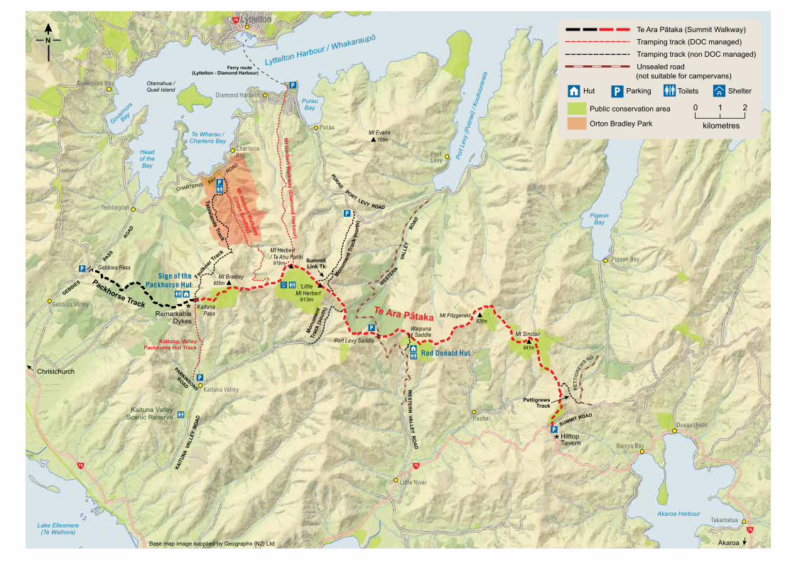
A great introduction to family tramping close to Christchurch Te Ara Pātaka (also known as Summit Walkway) is a 35 km route linking Gebbies Pass in the Lyttelton crater to Hilltop in the Akaroa crater. It follows a long high ridgeline that includes Mount Herbert/Te Ahu Patiki, the highest point on Banks Peninsula. Allow 2 ½ days to walk the full length, staying in Sign of the Packhorse and Rod Donald huts.
Preparation will make it a great experience Although the walkway is easily accessible the weather can change quickly, and it can be very cold and exposed on the tops. Make sure you are well equipped, with layered clothing and a water/wind-proof jacket. There is no drinking water on the way except at the huts and Mount Herbert Shelter – you must take water with you.
Working in partnershipVarious tracks connect to Te Ara Pātaka from valleys below, enabling a variety of day walks or shorter overnight tramps. This track and hut network is collectively managed by the Department of Conservation (DOC), the Rod Donald Banks Peninsula Trust and the Christchurch City Council, in cooperation with local landowners.
Crossing private farmlandAll tracks cross private farmland, so keep on the marked tracks and respect the working operations on the farms. Leave gates as you find them, taking extra care in large groups. Dogs are not permitted on any tracks, and mountain bikes are restricted to some tracks only. Firearms, motor vehicles or fires are also not permitted anywhere on this land. Track closures• Tracks west of Port Levy saddle are closed for lambing and
calving from 8 August to 15 September. • Tracks east of Port Levy saddle beyond Rod Donald Hut
are closed from 1 September to 25 October.
Getting there The easiest way to access Te Ara Pātaka is by private car, preferably by leaving a car at each end of the track. However, connecting tracks enable shorter loop walks, and public transport is available from Te Waipapa/Diamond Harbour and Hilltop Tavern. If parking at Hilltop, leave your vehicle at the furthest end of the car park from the tavern itself.You can also reach Te Ara Pātaka via several connecting tracks, including the Kaituna Valley Packhorse Hut Track, Mount Herbert Walkway, Tablelands/Faulkner tracks and the Monument Track (both north and south). The track can be picked up at Port Levy saddle, via Western Valley Road. Drive carefully: this unsealed road is winding, rough, steep and narrow. After heavy rain it may be passable only by 4WD vehicles.
Staying overnightOvernight stays are permitted at huts only. Currently camping outside the huts is permitted only at Sign of the Packhorse Hut. You must book to stay overnight at either or both of the huts before you arrive. Sign of the Packhorse and Rod Donald huts• Sign of the Packhorse Hut (DOC) and Rod Donald Hut
(Rod Donald Banks Peninsula Trust) make an excellent introduction to overnight tramping for families and youth groups.
• Both these 9-bunk serviced huts must be pre-booked through the DOC website or by contacting the DOC Christchurch Visitor Centre at the i-SITE in central Christchurch.
• There are rain-fed water tanks and toilets at both huts for day walkers.
• If staying overnight take a cookstove, pots and pans, sleeping bag and toilet paper.
The huts are both above 450 m in altitude so it can get chilly at night, even in summer. Each hut has a wood burner with firewood. This wood is only for use in the wood burner. No fires are permitted outside at any time.
Note: Rod Donald Hut has a state-of-the-art, ventilation-improved pit toilet. Once composted, its contents can be returned to the bush. DO NOT put non-biodegradable items (such as nappies) in either toilet. Take these out with you.
Rod Donald Hut. Photo: Suky Thompson Trampers well equipped for poor weather. Photo: Suky Thompson

Walking Te Ara PātakaThe following description covers the walkway from Gebbies Pass to Hilltop, but other access/exit points are possible and noted where relevant.
Gebbies Pass to Sign of the Packhorse Hut Time: 2 hrDistance: 5.8 kmTrack closed for lambing 8 August to 15 OctoberThis section of track is maintained by the Christchurch City Council.Getting there: The track starts near the crest of Gebbies Pass Road on the Lyttelton side, where there is a small car park. This is one of three tracks to Sign of the Packhorse Hut. It is marked with orange-topped poles. From the car park, take the marked track below the logging road. Soon it crosses open paddocks with lovely views over Lyttelton Harbour/Whakaraupō. When you leave the paddocks and encounter the logging road for the second time, don’t walk along it – make sure you cross over the road to enter the pine forest. The track climbs through the forest, eventually re-emerging into open land, then skirts below the Remarkable Dykes volcanic rock formations. The track ends at the historic Sign of the Packhorse Hut.
Kaituna Valley Packhorse Hut Track Time: 2 hrDistance: 4.1 km Track open year-roundGetting there: Take SH75 to Kaituna Valley Road. Turn left into Parkinsons Road approximately 6 km up the valley. Park near the road end where the track starts. This offers much more secure parking than Gebbies Pass. Sign of the Packhorse Hut can be accessed year-round via this track – other tracks beyond Packhorse Hut are closed for lambing between August and October. The track ambles through pasture and then forest, crossing the valley stream several times. In the summer you can use stepping stones to cross, but be prepared to get wet feet if the stream is up after rain. The track climbs steadily through the bush, and then up a more open grassy slope with wonderful views back down the valley.
Sign of the Packhorse Hut to Mount Herbert/Te Ahu Patiki summit Time: 3 hr Distance: 6.5 kmTrack closed for lambing 8 August to 15 OctoberHead east through Sign of the Packhorse Scenic Reserve through many young, regenerating lancewood trees. The track emerges from the reserve into open country and zig-zags steeply up the side of Mount Bradley, climbing 300 m. This is the toughest part of the track, so take a rest and admire the view of Lake Ellesmere (Te Waihora). After the last zig-zag the track heads east, skirting below the mountain's rocky massif through gorse, bush and regenerating scrub; you will have to pick over some rocky patches.The track emerges at a fence line on the pass between Mount Bradley and Mount Herbert. Cross at the stile and carry straight on near the fence. You will soon join a farm track; stay on the main track when a side track branches off to Orton Bradley Park. The Mount Herbert Shelter is a short distance along and has a toilet and water. From the shelter, return to the farm track. Turn right after about 400 m, up a smaller track that leads through gorse to the Mount Herbert/Te Ahu Patiki summit. If you miss this turnoff, there is another opportunity to reach the summit when the track from Te Waipapa/Diamond Harbour joins. There are stunning views from here on a good day. On a cloudy day it can be misty and confusing so watch closely for the track markers, which are closer together on this section.
Looking toward Akaroa Harbour from Montgomery Park Scenic Reserve. Photo: Andrew Smythe
Looking toward Lyttelton Harbour. Photo: Rangiora Tramping Club

Mount Herbert summit to Port Levy saddle Time: 2 hr 30 minDistance: 5.7 kmTrack closed for lambing 8 August to 15 OctoberFrom the summit of Mount Herbert, head south-east along the plateau through tussock grassland to reach the summit of ‘Little Mount Herbert’. Take great care in misty weather to follow the orange markers along the 1-km plateau between the two summits. You may encounter cattle grazing along the way. Give them space as you walk.From ‘Little Mount Herbert’, carry on south-east down a steep tussock slope, to pick up the marked farm track (punctuated by pine forest and old stands of remnant tōtara) to the Port Levy saddle car park on Western Valley Road.Port Levy saddle is at the top of Western Valley Road. This steep, narrow gravel road connects Little River to Port Levy. It is not suitable for campervans or towing vehicles, and can be difficult for 2WD vehicles after heavy rain. There is a parking area here providing easy access to Rod Donald Hut or Mount Herbert (if doing the track in reverse).
Port Levy saddle to Rod Donald Hut Time: 50 minDistance: 2.5 kmAccess to the hut is open year-roundCross Western Valley Road and follow the marked track to Waipuna Saddle. There is a beautiful old growth tōtara forest at Waipuna Saddle. This is on private land, but the landowner permits you to visit it. Please respect this very special place. Rod Donald Hut is down a side track and takes about 25 min to walk to from here. This section of the track is accessible by mountain bike, but bikes are best left at the top of the Rod Donald Hut track.The Rod Donald Hut is on private land belonging to the Rod Donald Banks Peninsula Trust and protected by a QEII National Trust covenant. As with Sign of the Packhorse Hut, bunks must be pre-booked through the DOC website, but day walkers are welcome to visit.
Te Ara Pātaka or Summit Walkway?Te Ara Pātaka, the name chosen by the four peninsula rūnanga (Wairewa, Ngāti Wheke, Ōnuku and Koukourārata), acknowledges the importance of the area as a food basket (pātaka) to their tupuna and the Māori name for Banks Peninsula, Te Pātaka o Rākaihautū. The name Summit Walkway acknowledges the vision of MP Harry Ell, the Summit Road Society and the many trampers who have walked and worked on these tracks over the last 100 years.
Mount Herbert/Te Ahu Patiki (919 m)Mount Herbert is the highest point on Banks Peninsula. Looking north over Lyttelton crater is Christchurch city, and a view beyond Pegasus Bay to the Kaikoura mountain ranges. To the west is Mount Bradley, the Canterbury plains and the Southern Alps/Kā Tiritiri o te Moana. To the south is Lake Ellesmere (Te Waihora) and Kaitorete Spit. The long, high plateau of Mount Herbert stretches to the east for nearly 1 km, with the far end being known as ‘Little Mount Herbert’. This is perhaps slightly unkind, as at 913 m it is only 6 m lower than the true summit.
Both summits have radio and mobile phone towers, and it can be confusing to know which you are on! Facing Lyttelton Harbour, Mount Herbert is at the left end with Little Mount Herbert at the right.
This place is important to Māori – the ancestors recognised its rounded shaped was similar to a flounder, naming it Te Ahu Patiki, ‘the shape of the flounder’.
Rod Donald Hut to Hilltop Time: 6 hrDistance: 14.3 kmTracks past Rod Donald Hut track junction are closed for lambing/calving 1 September to 25 OctoberFrom Rod Donald Hut, climb back up the access track to reach Waipuna Saddle. Then head east following the marked farm track through the tōtara graveyard, pasture and several DOC reserves.Mountain bikers leave the main track briefly to bypass the narrow rocky track through Mount Fitzgerald, and take an easier farm track.Soon after the Whatarangi Totara Scenic Reserve, the track diverges again. Walkers should head up to Montgomery Park Scenic Reserve and walk directly to Hilltop Tavern. The reserve track is steep and rocky, so take care and enjoy the beautiful forest including a giant tōtara, thought to be up to 2,000 years old. The track emerges from the reserve onto Summit Road. Keep children close and take extreme care to look and listen for vehicles as you cross the road. Walk along the other side of the road for about 100 m, then go over the stile to walk across the paddock to Hilltop Tavern.Mountain bikes are not permitted in Montgomery Park Scenic Reserve, so follow the farm track to Pettigrews Road; turn right at the end to reach the Summit Road, and right again to ride along the Summit Road to SH75 and then to Hilltop Tavern – about 3 km.
It takes six teenagers to link arms around the giant tōtara. Photo: Andrew Smythe The crater rim. Photo: Anna Pearson
913m
Tablelands Track
Akaroa
Mt Fitzgerald
Lyttelton
Otamahua / Quail Island
Packhorse Hut Track
Dykes
Unsealed road
Base map image supplied by Geographx (NZ) Ltd

Track gradesEasy tramping track – well formed track for comfortable overnight tramping/hiking.
Tramping track – mostly unformed but with track directional markers, poles or cairns. Backcountry skills and experience required.
Your safety is your responsibilityKnow the Outdoor Safety Code – 5 simple rules to help you stay safe:
1. Plan your trip2. Tell someone3. Be aware of the weather4. Know your limits5. Take sufficient supplies
More information at www.adventuresmart.org.nz.
Te Ara Pātaka – alternative track entrances and exits There are many different tracks linking to Te Ara Pātaka, providing a range of opportunities for day walks or single overnight tramps. The following is a brief summary of tracks not already mentioned. For further details, refer to the Banks Peninsula Walks or DOC websites.
Tablelands and Faulkner tracks Time: 3 hrDistance: 7.1 kmFaulkner Track closed for lambing 8 August to 15 OctoberGetting there: Orton Bradley Park is on Charteris Bay Road on the southern side of Lyttelton Harbour. There is a small fee to enter the park, which has a lovely collection of historic buildings, a variety of shorter walks, toilets, a summer café and safe parking. Ensure you return to your vehicle in good time as the park gates are locked overnight. Park in upper Orton Bradley car park and follow the marked track to Sign of the Packhorse Hut. The track climbs up steadily through forest and pastoral land in the park. After leaving the park the track joins Faulkner Track, a farm track through private farmland, then continues up the flank of Mount Bradley. Heading west, the track eventually levels out a bit and goes through a patch of bush. Here it becomes less distinct; after leaving the bush it picks through a rocky area, eventually arriving at Sign of the Packhorse Hut.
Mount Herbert Walkway This walkway links Orton Bradley Park to Diamond Harbour via the summit of Mount Herbert/Te Ahu Patiki. It provides two excellent ways to join Te Ara Pātaka from Lyttelton Harbour. Time: 4 hr up to Mount Herbert summit from either trackDistance: Diamond Harbour section 8.5 km. Orton Bradley section 7.8 kmWalkway is closed for lambing 8 August to 15 OctoberGetting there: Diamond Harbour section – get to Diamond Harbour by ferry from Lyttelton, or drive around on the Lyttelton Harbour coastal road. The track starts at the jetty or you can join it from the coastal road (called Marine Drive in Diamond Harbour).
Orton Bradley section – get to Orton Bradley Park and park in the upper car park as described in the section above. Follow the Valley Track to the edge of the park, and then continue to Te Ara Pātaka on the marked track.
Note: Most of the track is in open country and is very exposed – be prepared for all weather conditions. There is little water along the way so take plenty with you.
Orton Bradley Park loop Time: 9–10 hr loop (including summit)Distance: 20 kmWalkway is closed for lambing 8 August to 15 OctoberAn option for a loop track starting and finishing at Orton Bradley Park is to take Faulkner Track to Sign of the Packhorse Hut, then come back down the Orton Bradley section of Mount Herbert Walkway. This makes an excellent 2-day tramp, with an overnight stay at Sign of the Packhorse Hut.
Monument Track (north and south) Monument Track links Purau saddle in the north to Kaituna Valley Road in the south, joining Te Ara Pātaka for around 500 m along the ridgeline.
Monument Track (north) from Purau saddle car park to Te Ara PātakaTime: 1 hr 30 min Distance: 4 kmTrack is closed for lambing 8 August to 15 OctoberGetting there: Follow the Lyttelton Harbour coastal road through Diamond Harbour to Purau. Turn right on the Port Levy Road and park at the Purau saddle car park.Note: The Monument Track is the easiest and quickest way to reach the summit of Mount Herbert. You will pass the old Monument Hut, built in the 1950s by Colin and Ben Faulkner who worked for many years on these tracks as volunteers. You are on private land and close to the sheep yards here, so please respect any farming in progress.
!

Monument Track (south) from Kaituna Valley to Te Ara Pātaka Time: 1 hr 30 minDistance: 2.7 kmTrack is closed for lambing 8 August to 15 OctoberGetting there: Take SH75 to Kaituna Valley Road. Monument Track starts at the end of Kaituna Valley Road. Park by the sign at the farm gate at the end of the road. Walk past the yellow farmhouse, and follow the marked track to join Te Ara Pātaka.Note: The property to Te Ara Pātaka belongs to the Parrs, who live at the farm and recently retired it from grazing to facilitate native forest regeneration. It is now under a Banks Peninsula Conservation Trust covenant to protect it for the future.
Kaituna Valley loop An option for a loop track is to take the Kaituna Valley Packhorse Hut Track to Te Ara Pātaka, and then the Monument Track (south) back to Kaituna Valley. The loop completes with a 6 km walk back down the quiet (and very pretty) Kaituna Valley Road to the starting point. This loop makes an excellent 1½-day tramp with a short first day, an overnight stay at Sign of the Packhorse Hut, and a longer second day.Time: 10 hrDistance: 23.5 kmTrack beyond Sign of the Packhorse Hut is closed for lambing 8 August to 15 OctoberGetting there: Take SH75 to Kaituna Valley Road. Parkinsons Road is approximately 6 km up the valley. Park near the road end where the Kaituna Valley to Packhorse Hut Track starts.
Banks Peninsula: a dramatically-changed landscape
The astonishing tōtara graveyard bears witness to transformation of the pre-European landscape from thick forest to pastoral farmland. Timber milling began in the 1850s, soon after the arrival of pākehā pioneers. Great trees were felled and logs dragged by bullock teams to mills in the valleys below. Most of the milled timber was transported to Christchurch to build the early city. Fire was used extensively to clear the remaining brush and smaller trees, and the land was seeded with cocksfoot grass. Note the old tōtara fences still standing from those early pioneer farms, a tribute to the durability of this ancient timber.
Scenic reserves at Mount Fitzgerald, Mount Sinclair, Whatarangi and Montgomery Park protect remnants of old-growth native forest, with ancient remains showing the hardships of their exposure to fire and weather. There is a wealth of regeneration taking place in these reserves, thanks to the exclusion of grazing stock. Some of the subalpine species here include Hall's tōtara, tree fuchsia/kōtukutuku, broadleaf/kāpuka and dracophyllum.
Many private landowners are also protecting forest remnants and regenerating growth with conservation covenants.
This giant tōtara in Montgomery Park Scenic Reserve could be up to 2,000 years old. Photo: Suky Thompson
Tōtara forest remnants and skeleton trees. Photo: Janey Thomas
• Plan ahead and prepare
• Keep to marked tracks and stay overnight at huts only
• Dispose of waste properly
• Leave what you find
• High fire danger – absolutely no fires
• Respect wildlife and farm animals
• Be considerate of others