Embed Size (px)
Citation preview
Hurricane Dorian 09.02.19 Analysis
Risk Services Division
2 September 2019 Legal Notice All consulting services performed by HUB are advisory in nature. All resultant reports are based upon conditions and practices observed by HUB and information supplied by the client. Any such reports may not identify or contemplate all unsafe conditions and practices; others may exist. HUB does not imply, guarantee or warrant the safety of any of the client’s properties or operations or that the client or any such properties or operations are in compliance with all federal, state or local laws, codes, statutes, ordinances, standards or recommendations. All decisions in connection with the implementation, if any, of any of HUB’s advice or recommendations shall be the sole responsibility of, and be made by, the client. The advice and recommendations submitted in this plan constitute neither a warranty of future results nor an assurance against risk. This material represents the best judgment of HUB and is based on information obtained from both open and closed sources.
HUB Risk Services Hurricane Dorian
Sensitive For Official Use Only
2 September 2019 09:00 AM EDT
Sensitive
For Official Use Only Page 2 of 16
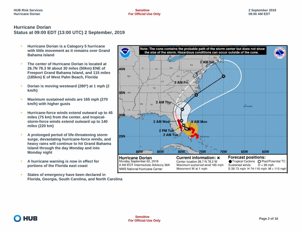
Hurricane Dorian Status at 09:00 EDT (13:00 UTC) 2 September, 2019
Hurricane Dorian is a Category 5 hurricane with little movement as it remains over Grand Bahama Island
The center of Hurricane Dorian is located at 26.7N 78.3 W about 30 miles (50km) ENE of Freeport Grand Bahama Island, and 115 miles (185km) E of West Palm Beach, Florida
Dorian is moving westward (280º) at 1 mph (2 km/h)
Maximum sustained winds are 165 mph (270 km/h) with higher gusts
Hurricane-force winds extend outward up to 45 miles (75 km) from the center, and tropical-storm-force winds extend outward up to 140 miles (220 km)
A prolonged period of life-threatening storm surge, devastating hurricane-force winds, and heavy rains will continue to hit Grand Bahama Island through the day Monday and into Monday night
A hurricane warning is now in effect for portions of the Florida east coast
States of emergency have been declared in Florida, Georgia, South Carolina, and North Carolina
HUB Risk Services Hurricane Dorian
Sensitive For Official Use Only
2 September 2019 09:00 AM EDT
Sensitive
For Official Use Only Page 3 of 16
Summary
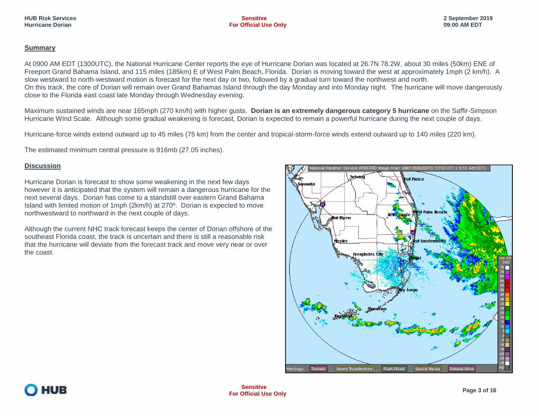
At 0900 AM EDT (1300UTC), the National Hurricane Center reports the eye of Hurricane Dorian was located at 26.7N 78.2W, about 30 miles (50km) ENE of Freeport Grand Bahama Island, and 115 miles (185km) E of West Palm Beach, Florida. Dorian is moving toward the west at approximately 1mph (2 km/h). A slow westward to north-westward motion is forecast for the next day or two, followed by a gradual turn toward the northwest and north. On this track, the core of Dorian will remain over Grand Bahamas Island through the day Monday and into Monday night. The hurricane will move dangerously close to the Florida east coast late Monday through Wednesday evening. Maximum sustained winds are near 165mph (270 km/h) with higher gusts. Dorian is an extremely dangerous category 5 hurricane on the Saffir-Simpson Hurricane Wind Scale. Although some gradual weakening is forecast, Dorian is expected to remain a powerful hurricane during the next couple of days. Hurricane-force winds extend outward up to 45 miles (75 km) from the center and tropical-storm-force winds extend outward up to 140 miles (220 km). The estimated minimum central pressure is 916mb (27.05 inches).
Discussion
Hurricane Dorian is forecast to show some weakening in the next few days however it is anticipated that the system will remain a dangerous hurricane for the next several days. Dorian has come to a standstill over eastern Grand Bahama Island with limited motion of 1mph (2km/h) at 270º. Dorian is expected to move northwestward to northward in the next couple of days. Although the current NHC track forecast keeps the center of Dorian offshore of the southeast Florida coast, the track is uncertain and there is still a reasonable risk that the hurricane will deviate from the forecast track and move very near or over the coast.
HUB Risk Services Hurricane Dorian
Sensitive For Official Use Only
2 September 2019 09:00 AM EDT
Sensitive
For Official Use Only Page 4 of 16
Key Messages
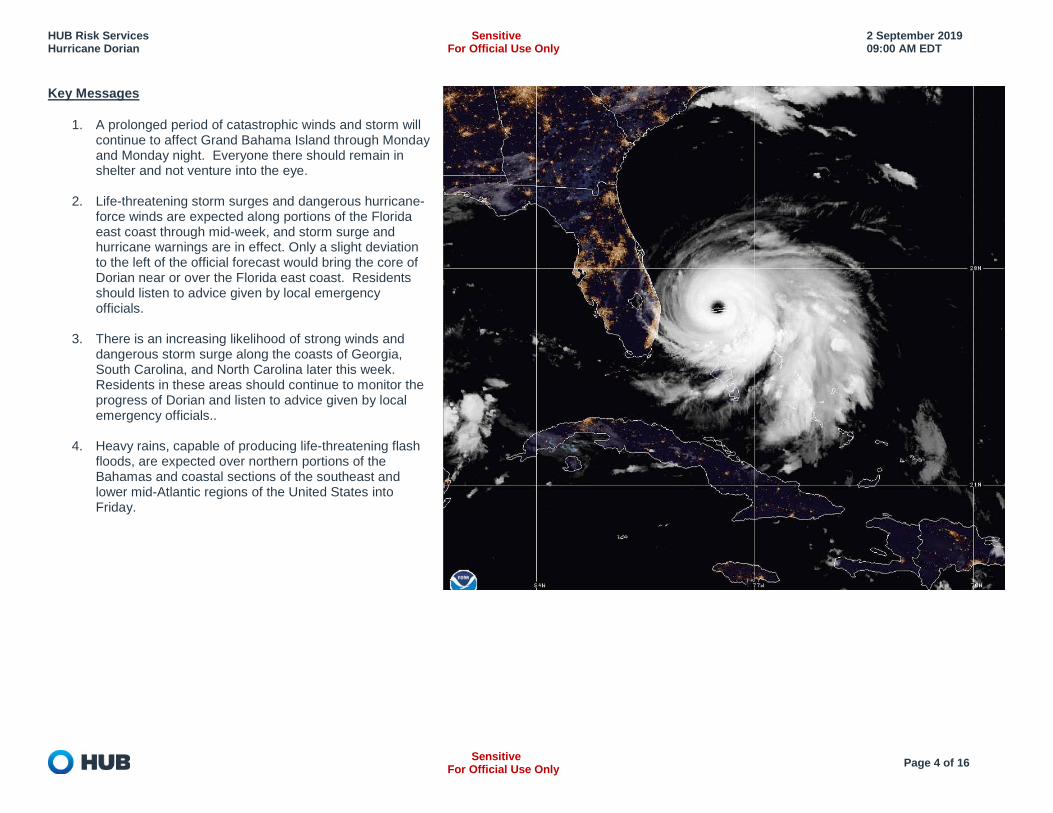
1. A prolonged period of catastrophic winds and storm will continue to affect Grand Bahama Island through Monday and Monday night. Everyone there should remain in shelter and not venture into the eye.
2. Life-threatening storm surges and dangerous hurricane-
force winds are expected along portions of the Florida east coast through mid-week, and storm surge and hurricane warnings are in effect. Only a slight deviation to the left of the official forecast would bring the core of Dorian near or over the Florida east coast. Residents should listen to advice given by local emergency officials.
3. There is an increasing likelihood of strong winds and
dangerous storm surge along the coasts of Georgia, South Carolina, and North Carolina later this week. Residents in these areas should continue to monitor the progress of Dorian and listen to advice given by local emergency officials..
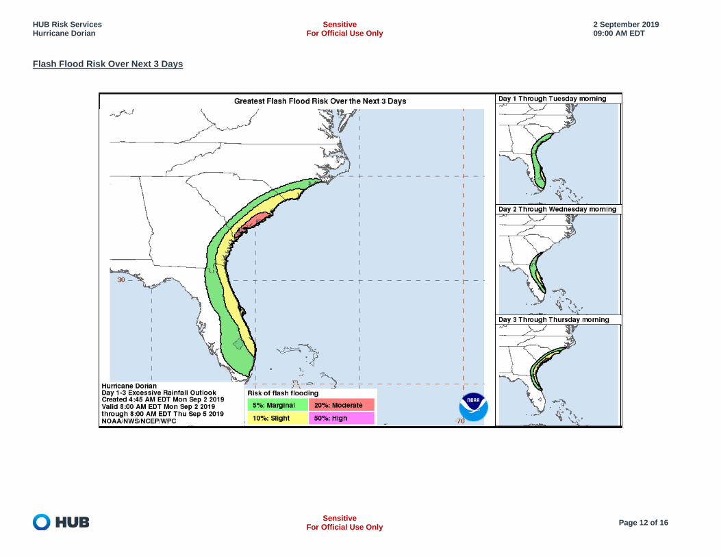
4. Heavy rains, capable of producing life-threatening flash
floods, are expected over northern portions of the Bahamas and coastal sections of the southeast and lower mid-Atlantic regions of the United States into Friday.
HUB Risk Services Hurricane Dorian
Sensitive For Official Use Only
2 September 2019 09:00 AM EDT
Sensitive
For Official Use Only Page 5 of 16
Watches and Warnings
A hurricane warning is in effect for Grand Bahama and the Abacos Islands in the northwestern Bahamas A hurricane warning is in effect for Jupiter Inlet to the Volusia/Brevard County line A hurricane watch is in effect for north of Deerfield Beach to Jupiter Inlet and Volusia/Brevard County line to the mouth of the St. Mary’s River A Tropical Storm Warning is in effect for North of Deerfield Beach to Jupiter Inlet A Tropical Storm Watch is in effect for North of Golden Beach to Deerfield Beach and Lake Okeechobee A Storm Surge Warning is in effect for Lantana to the Volusia/Brevard County Line A Storm Surge Watch is in effect for North of Deerfield Beach to south of Lantana and Volusia/Brevard County Line to the Mouth of the St. Mary's River
A Storm Surge Warning means there is a danger of life-threatening inundation, from rising water moving inland from the coastline, during the next 36 hours in the indicated locations. This is a life-threatening situation. Persons located within these areas should take all necessary actions to protect life and property from rising water and the potential for other dangerous conditions. Promptly follow evacuation and other instructions from local officials. A Storm Surge Watch means there is a possibility of life-threatening inundation, from rising water moving inland from the coastline, in the indicated locations during the next 48 hours. A Hurricane Warning means that hurricane conditions are expected somewhere within the warning area. A warning is typically issued 36 hours before the anticipated first occurrence of tropical-storm-force winds, conditions that make outside preparations difficult or dangerous. Preparations to protect life and property should be rushed to completion. A Hurricane Watch means that hurricane conditions are possible within the watch area. A watch is typically issued 48 hours before the anticipated first occurrence of tropical-storm-force winds, conditions that make outside preparations difficult or dangerous. A Tropical Storm Warning means that tropical storm conditions are expected somewhere within the warning area within 36 hours. A Tropical Storm Watch means that tropical storm conditions are possible within the watch area, generally within 48 hours.
HUB Risk Services Hurricane Dorian
Sensitive For Official Use Only
2 September 2019 09:00 AM EDT
Sensitive
For Official Use Only Page 6 of 16
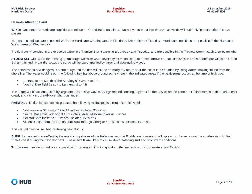
Hazards Affecting Land
WIND: Catastrophic hurricane conditions continue on Grand Bahama Island. Do not venture out into the eye, as winds will suddenly increase after the eye passes. Hurricane conditions are expected within the Hurricane Warning area in Florida by late tonight or Tuesday. Hurricane conditions are possible in the Hurricane Watch area on Wednesday. Tropical storm conditions are expected within the Tropical Storm warning area today and Tuesday, and are possible in the Tropical Storm watch area by tonight. STORM SURGE: A life-threatening storm surge will raise water levels by as much as 18 to 23 feet above normal tide levels in areas of onshore winds on Grand Bahama Island. Near the coast, the surge will be accompanied by large and destructive waves. The combination of a dangerous storm surge and the tide will cause normally dry areas near the coast to be flooded by rising waters moving inland from the shoreline. The water could reach the following heights above ground somewhere in the indicated areas if the peak surge occurs at the time of high tide:
Lantana to the Mouth of the St. Mary's River...4 to 7 ft North of Deerfield Beach to Lantana...2 to 4 ft
The surge will be accompanied by large and destructive waves. Surge-related flooding depends on the how close the center of Dorian comes to the Florida east coast, and can vary greatly over short distances. RAINFALL: Dorian is expected to produce the following rainfall totals through late this week:
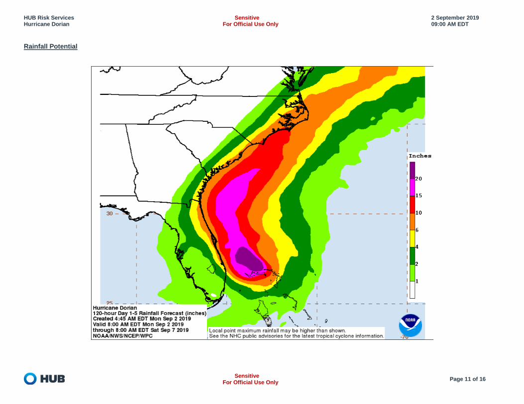
• Northwestern Bahamas: 12 to 24 inches, isolated 30 inches • Central Bahamas: additional 1 - 3 inches, isolated storm totals of 6 inches • Coastal Carolinas:5 to 10 inches, isolated 15 inches • Atlantic Coast from the Florida peninsula through Georgia: 4 to 8 inches, isolated 10 inches
This rainfall may cause life-threatening flash floods. SURF: Large swells are affecting the east-facing shores of the Bahamas and the Florida east coast and will spread northward along the southeastern United States coast during the next few days. These swells are likely to cause life-threatening surf and rip current conditions. Tornadoes: Isolate tornadoes are possible this afternoon into tonight along the immediate coast of east-central Florida.

HUB Risk Services Hurricane Dorian
Sensitive For Official Use Only
2 September 2019 09:00 AM EDT
Sensitive
For Official Use Only Page 7 of 16
Current Predicted Path
HUB Risk Services Hurricane Dorian
Sensitive For Official Use Only
2 September 2019 09:00 AM EDT
Sensitive
For Official Use Only Page 8 of 16
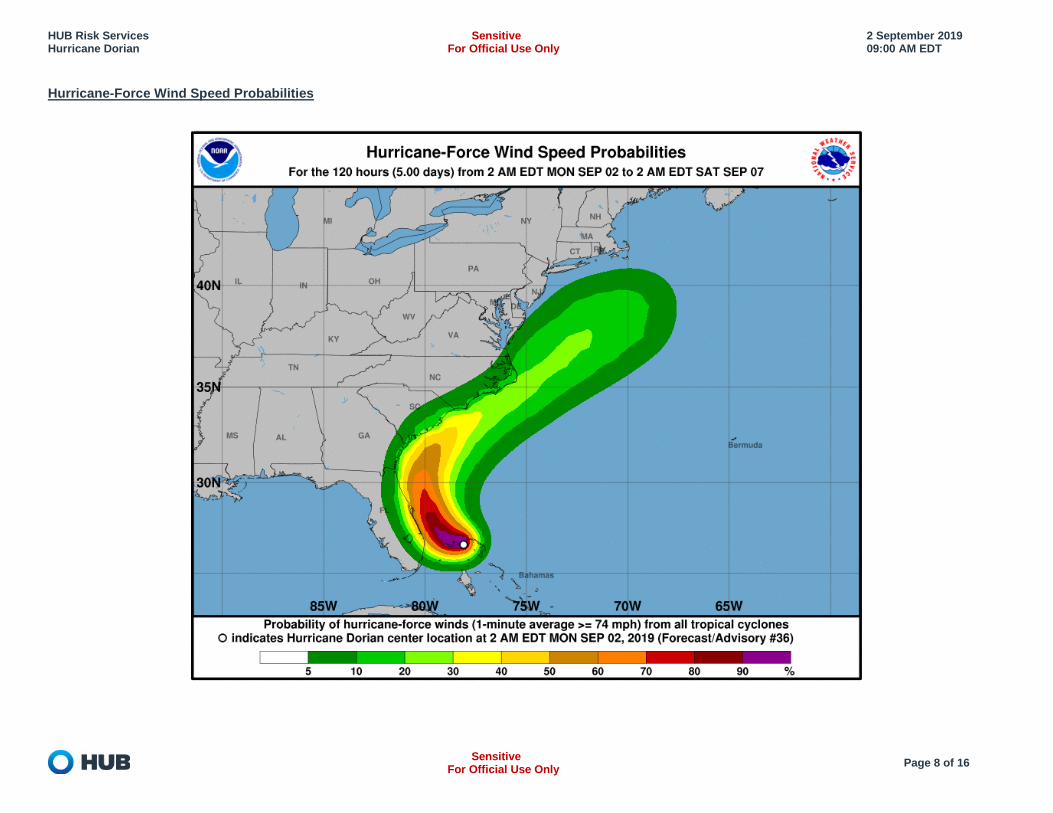
Hurricane-Force Wind Speed Probabilities
HUB Risk Services Hurricane Dorian
Sensitive For Official Use Only
2 September 2019 09:00 AM EDT
Sensitive
For Official Use Only Page 9 of 16
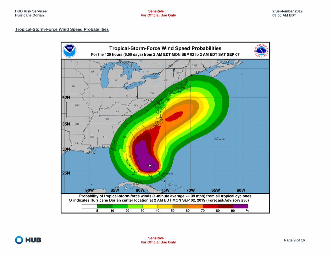
Tropical-Storm-Force Wind Speed Probabilities
HUB Risk Services Hurricane Dorian
Sensitive For Official Use Only
2 September 2019 09:00 AM EDT
Sensitive
For Official Use Only Page 10 of 16
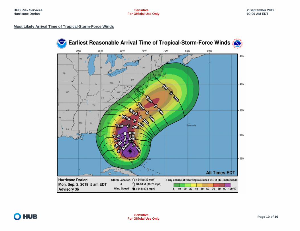
Most Likely Arrival Time of Tropical-Storm-Force Winds
HUB Risk Services Hurricane Dorian
Sensitive For Official Use Only
2 September 2019 09:00 AM EDT
Sensitive
For Official Use Only Page 11 of 16
Rainfall Potential
HUB Risk Services Hurricane Dorian
Sensitive For Official Use Only
2 September 2019 09:00 AM EDT
Sensitive
For Official Use Only Page 12 of 16
Flash Flood Risk Over Next 3 Days

HUB Risk Services Hurricane Dorian
Sensitive For Official Use Only
2 September 2019 09:00 AM EDT
Sensitive
For Official Use Only Page 13 of 16
Storm Surge Watch/Warning Graphic
HUB Risk Services Hurricane Dorian
Sensitive For Official Use Only
2 September 2019 09:00 AM EDT
Sensitive
For Official Use Only Page 14 of 16
Safety Procedures & Readiness
Hurricane Hazards
While hurricanes pose the greatest threat to life and property, tropical storms and depressions also can be devastating. The primary hazards from tropical cyclones (which include tropical depressions, tropical storms, and hurricanes) are storm surge flooding, inland flooding from heavy rains, destructive winds, tornadoes, and high surf and rip currents.
Storm surge is the abnormal rise of water generated by a storm's winds. This hazard is historically the leading cause of hurricane related deaths in the United States. Storm surge and large battering waves can result in large loss of life and cause massive destruction along the coast.
Storm surge can travel several miles inland, especially along bays, rivers, and estuaries. Flooding from heavy rains is the second leading cause of fatalities from landfalling tropical cyclones. Widespread torrential rains associated with these
storms often cause flooding hundreds of miles inland. This flooding can persist for several days after a storm has dissipated Winds from a hurricane can destroy buildings and manufactured homes. Signs, roofing material, and other items left outside can become flying missiles
during hurricanes. Tornadoes can accompany landfalling tropical cyclones. These tornadoes typically occur in rain bands well away from the center of the storm Dangerous waves produced by a tropical cyclone's strong winds can pose a significant hazard to coastal residents and mariners. These waves can cause
deadly rip currents, significant beach erosion, and damage to structures along the coastline, even when the storm is more than a 1,000 miles offshore Now is the time to prepare. All residents and visitors in the path of Hurricane Lane should review these tips:
Check to make sure your emergency kit is stocked and test your family communications plan. Know your evacuation routes and how to find higher ground. Determine where you would go, and how you would get there if instructed to evacuate. If
directed to evacuate by local officials, evacuate. Stay vigilant and continue to monitor local radio or TV stations and local emergency management officials for updated weather and emergency information.
The FEMA App (available in English and Spanish) provides National Weather Service alerts (for up to 5 areas), emergency kit checklists, directions to open shelters, safety preparation tips and more.
Make plans to secure your property: o Cover all of your home’s windows. Permanent storm shutters offer the best protection for windows. A second option is to board up windows with
5/8” marine plywood, cut to fit and ready to install. Tape does not prevent windows from breaking. o Reinforce your garage doors; if wind enters a garage it can cause dangerous and expensive structural damage. o Plan to bring in all outdoor furniture, decorations, garbage cans, and anything else that is not tied down. o Determine how and where to secure boats and other marine craft.
You can safely install a generator for emergencies. Remember, never run a generator inside and keep it away from windows, doors, and vents. If using candles, please use caution. If possible, use flashlights instead. If you must use candles, do not burn them on or near anything that can catch fire. Your phone is an important tool to ensure your family’s safety. Make sure to charge your phone and other electronic devices. Businesses of all sizes are encouraged to follow local public safety authority direction and to share safety messaging with employees in order to reduce
risk. If you have a National Flood Insurance Program (NFIP) flood insurance policy, you may be eligible for reimbursement for actions taken to protect your
property. Call your insurance agent to find out more.
HUB Risk Services Hurricane Dorian
Sensitive For Official Use Only
2 September 2019 09:00 AM EDT
Sensitive
For Official Use Only Page 15 of 16
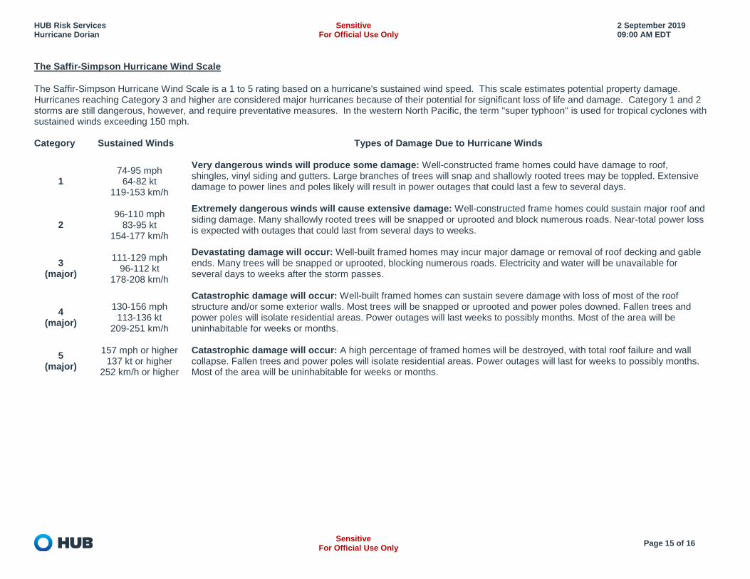
The Saffir-Simpson Hurricane Wind Scale
The Saffir-Simpson Hurricane Wind Scale is a 1 to 5 rating based on a hurricane's sustained wind speed. This scale estimates potential property damage. Hurricanes reaching Category 3 and higher are considered major hurricanes because of their potential for significant loss of life and damage. Category 1 and 2 storms are still dangerous, however, and require preventative measures. In the western North Pacific, the term "super typhoon" is used for tropical cyclones with sustained winds exceeding 150 mph. Category Sustained Winds Types of Damage Due to Hurricane Winds
1 74-95 mph
64-82 kt 119-153 km/h
Very dangerous winds will produce some damage: Well-constructed frame homes could have damage to roof, shingles, vinyl siding and gutters. Large branches of trees will snap and shallowly rooted trees may be toppled. Extensive damage to power lines and poles likely will result in power outages that could last a few to several days.
2 96-110 mph
83-95 kt 154-177 km/h
Extremely dangerous winds will cause extensive damage: Well-constructed frame homes could sustain major roof and siding damage. Many shallowly rooted trees will be snapped or uprooted and block numerous roads. Near-total power loss is expected with outages that could last from several days to weeks.
3 (major)
111-129 mph 96-112 kt
178-208 km/h
Devastating damage will occur: Well-built framed homes may incur major damage or removal of roof decking and gable ends. Many trees will be snapped or uprooted, blocking numerous roads. Electricity and water will be unavailable for several days to weeks after the storm passes.
4 (major)
130-156 mph 113-136 kt
209-251 km/h
Catastrophic damage will occur: Well-built framed homes can sustain severe damage with loss of most of the roof structure and/or some exterior walls. Most trees will be snapped or uprooted and power poles downed. Fallen trees and power poles will isolate residential areas. Power outages will last weeks to possibly months. Most of the area will be uninhabitable for weeks or months.
5 (major)
157 mph or higher 137 kt or higher
252 km/h or higher
Catastrophic damage will occur: A high percentage of framed homes will be destroyed, with total roof failure and wall collapse. Fallen trees and power poles will isolate residential areas. Power outages will last for weeks to possibly months. Most of the area will be uninhabitable for weeks or months.
HUB Risk Services Hurricane Dorian
Sensitive For Official Use Only
2 September 2019 09:00 AM EDT
Sensitive
For Official Use Only Page 16 of 16
For Additional Information:
American Red Cross http://www.redcross.org/ US Coast Guard Storm Center https://www.uscg.mil/news/stormcenter/ US National Hurricane Center www.nhc.noaa.gov US Federal Emergency Management Agency http://www.ready.gov/hurricanes FEMA – Mobile App https://www.fema.gov/mobile-app FEMA – Flooding https://www.fema.gov/media-library-data/1522342356506-
54bd8d92d0d0d07bca4c1250ebde2b21/Flood_508.pdf Ready Gov www.ready.gov Listo Gov (Spanish) www.listo.gov Emergency Management Agencies https://www.fema.gov/emergency-management-agencies Caribbean Disaster Emergency Management Agency http://www.cdema.org/index.php?option=com_wrapper&view=wrapper&Itemid=417 Smart Traveler Enrollment Program https://step.state.gov/