Embed Size (px)
Citation preview
How Argyle Square Came To Be IN 1769, Argyle Square is in the centre of a field, from which the future Battle Bridge Estate will be developed. It is a pit of dereliction, and includes the famous Dust Heap, described as a mountain of bones and cinders, just in the curve of what
will be Gray’s Inn Road. By 1801, the thoroughfares St. Chad’s Row, which will become Gray’s Inn Road, and the New Road, later Euston Road, have been created. Argyle Square is where the larger pond is shown, and the gentle curve of the field boundary to the south survives as Argyle Walk. In 1824, Thomas Dunston, William Robinson, and William Flanders purchase the 16½ acres of the field, and with a private Act of Parliament, create the Battle Bridge Estate, together with rights to develop
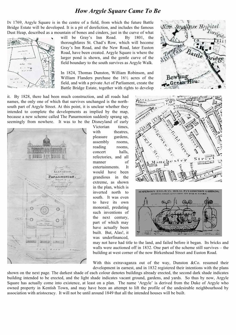
it. By 1828, there had been much construction, and all roads had names, the only one of which that survives unchanged is the north-south part of Argyle Street. At this point, it is unclear whether they intended to complete the developments as implied by the map, because a new scheme called The Panarmonion suddenly sprang up, seemingly from nowhere. It was to be the Disneyland of early
Victorian times, with theatres, pleasure gardens, assembly rooms, reading rooms, concert halls, refectories, and all manner of entertainments. It would have been grandious in the extreme, as shown in the plan, which is inverted north to south. It was even to have its own monorail, predating such inventions of the next century, part of which may have actually been built. But, Alas!, it was underfinanced, may not have had title to the land, and failed before it began. Its bricks and walls were auctioned off in 1832. One part of the scheme still survives – the building at west corner of the now Birkenhead Street and Euston Road. With this extravaganza out of the way, Dunston &Co. resumed their development in earnest, and in 1832 registered their intentions with the plans
shown on the next page. The darkest shade of each colour denotes buildings already erected, the second dark shade indicates building intended to be erected, and the light shade indicates vacant ground, gardens, and yards. So thus by now, Argyle Square has actually come into existence, at least on a plan. The name ‘Argyle’ is derived from the Duke of Argyle who owned property in Kentish Town, and may have been an attempt to lift the profile of the undesirable neighbourhood by association with aristocracy. It will not be until around 1849 that all the intended houses will be built.
It was never a high status area, and starting in 1827, there were multiple complaints to the Vestry of bad behaviour and prostitution. From the 1860s the neighbourhood declined further with many of the local houses turned over to “hotels” which were in fact brothels. In fact, 74 local addresses have been prosecuted for prostitution over the years, including 11 in Argyle Square. By 1889, when Booth’s Poverty Map was published, Argyle Square was coloured red, meaning houses “with two servants” but the rest of the neighbourhood was coloured black – “semi-criminal” – or blue – “chronic want” – or purple – “working class comfort.”
This situation continued throughout the 19th century, and various maps show Argyle Square much as in 1894, left. By 1922, the houses on the north side have been replaced by industrial premises, and by 1959, below, the landscaping has changed, and all the surrounding streets have their modern names. Prostitution is as popular as ever, and by the 1980s, Argyle Square becomes the very metaphor for vice in London, featuring regularly in the popular press and even in Hansard. By 1977, below right, the Square has the basketball court and playground. But by all reports, vice and dereliction continued until a major cleanup, both physically and morally, in
the 1990s, gave us the lovely garden square that we enjoy today. Looking at the Square below on a sunny day, no one would guess its history but only think of one of the small garden gems of central London, used, enjoyed and played in by many.
Dr Henry Fitzhugh, 2009
With thanks to the Camden Local Studies and Archive Centre for most of these pictures. pictures.