Embed Size (px)
Citation preview
8
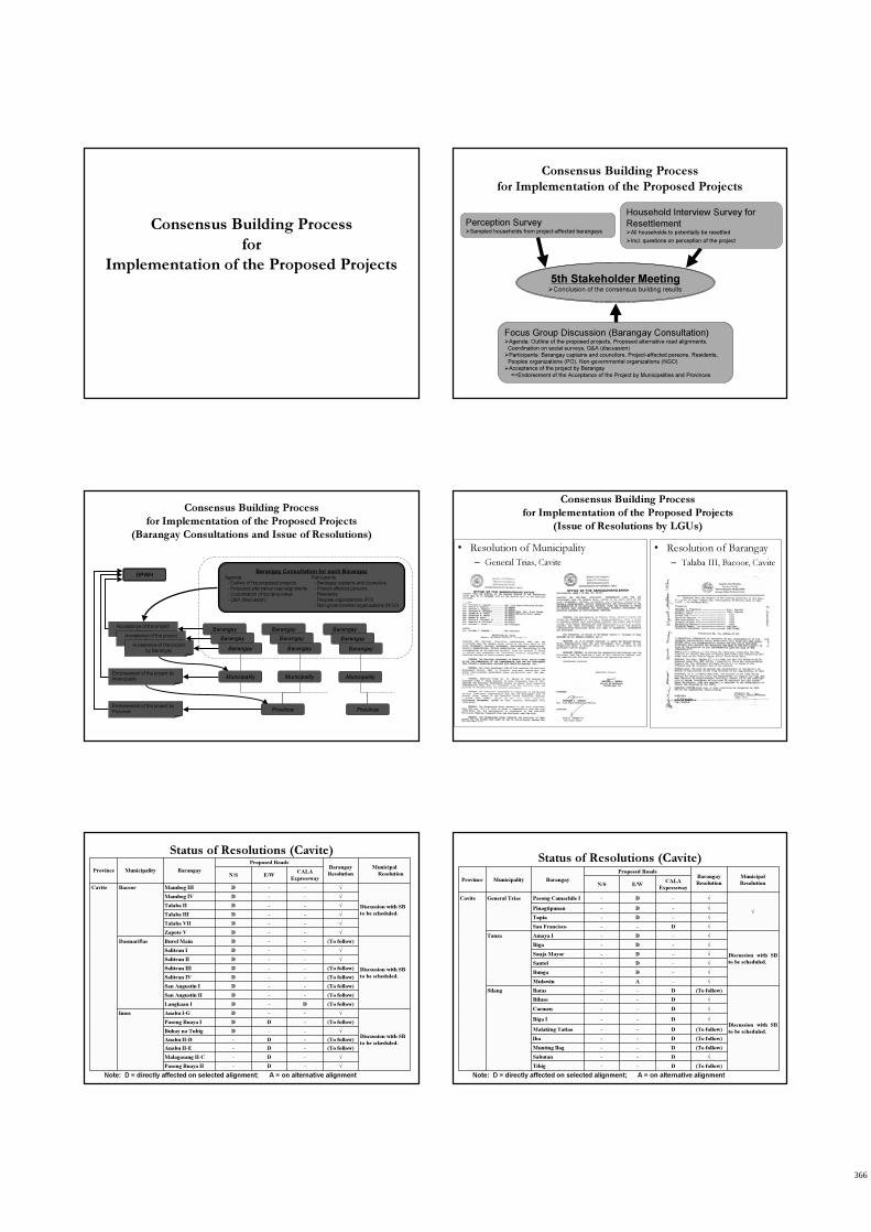
Consensus Building Process
for
Implementation of the Proposed Projects
Consensus Building Process
for Implementation of the Proposed Projects
5th Stakeholder Meeting�Conclusion of the consensus building results
Focus Group Discussion (Barangay Consultation)�Agenda: Outline of the proposed projects, Proposed alternative road alignments,
Coordination on social surveys, Q&A (discussion)
�Participants: Barangay captains and councilors, Project-affected persons, Residents,
Peoples organizations (PO), Non-governmental organizations (NGO)
�Acceptance of the project by Barangay
=>Endorsement of the Acceptance of the Project by Municipalities and Provinces
Perception Survey�Sampled households from project-affected barangays
Household Interview Survey for
Resettlement�All households to potentially be resettled
�Incl. questions on perception of the project
Consensus Building Process
for Implementation of the Proposed Projects
(Barangay Consultations and Issue of Resolutions)
Barangay Consultation for each BarangayAgenda:
- Outline of the proposed projects
- Proposed alternative road alignments
- Coordination of social surveys
- Q&A (discussion)
BarangayAcceptance of the project
by Barangay
Endorsement of the project by
Municipality
Barangay
Barangay
Barangay
Barangay
Barangay
Endorsement of the project by
Province
Acceptance of the project
by BarangayAcceptance of the project
by Barangay
Municipality
DPWH
Province
Participants: - Barangay captains and councilors
- Project-affected persons
- Residents
- Peoples organizations (PO)
- Non-governmental organizations (NGO)
Municipality
Barangay
Barangay
Barangay
Municipality
Province
Consensus Building Process
for Implementation of the Proposed Projects
(Issue of Resolutions by LGUs)
• Resolution of Barangay
– Talaba III, Bacoor, Cavite
• Resolution of Municipality
– General Trias, Cavite
Status of Resolutions (Cavite)
√-D-Pasong Buaya II
√-D-Malagasang II-C
(To follow)-D-Anabu II-E
(To follow)-D-Anabu II-D
√--DBuhay na Tubig
(To follow)-DDPasong Buaya I
Discussion with SB
to be scheduled.
√--DAnabu I-GImus
(To follow)D-DLangkaan I
(To follow)--DSan Augustin II
(To follow)--DSan Augustin I
(To follow)--DSalitran IV
(To follow)--DSalitran III
√--DSalitran II
√--DSalitran I
Discussion with SB
to be scheduled.
(To follow)--DBurol MainDasmariñas
√--DZapote V
√--DTalaba VII
√--DTalaba III
√--DTalaba II
√--DMambog IV
Discussion with SB
to be scheduled.
√--DMambog IIIBacoorCavite
CALA
ExpresswayE/WN/S
Municipal
Resolution
Barangay
Resolution
Proposed Roads
BarangayMunicipalityProvince
Note: D = directly affected on selected alignment; A = on alternative alignment
Status of Resolutions (Cavite)
(To follow)D--Tibig
√D--Sabutan
(To follow)D--Munting Ilog
(To follow)D--Iba
(To follow)D--Malaking Tatiao
√D--Biga I
√D--Carmen
√D--Biluso
Discussion with SB
to be scheduled.
(To follow)D--BatasSilang
√-A-Mulawin
√-D-Bunga
√-D-Santol
√-D-Sanja Mayor
√-D-Biga
Discussion with SB
to be scheduled.
√-D-Amaya ITanza
√D--San Francisco
√-D-Tapia
√-D-Pinagtipunan
√
√-D-Pasong Camachile IGeneral TriasCavite
CALA
ExpresswayE/WN/S
Municipal
Resolution
Barangay
Resolution
Proposed Roads
BarangayMunicipalityProvince
Note: D = directly affected on selected alignment; A = on alternative alignment
366
9
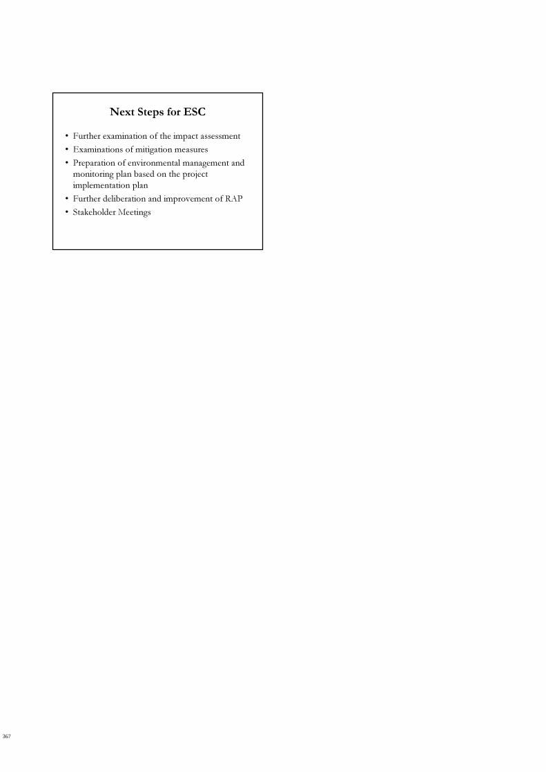
Next Steps for ESC
• Further examination of the impact assessment
• Examinations of mitigation measures
• Preparation of environmental management and
monitoring plan based on the project
implementation plan
• Further deliberation and improvement of RAP
• Stakeholder Meetings
367
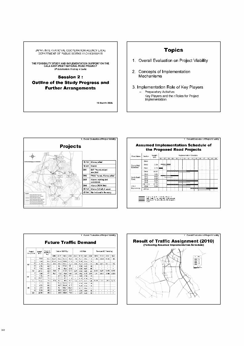
1
JAPAN INTERNATIONAL COOPERATION AGENCY (JICA)
DEPARTMENT OF PUBLIC WORKS AND HIGHWAYS
THE FEASIBILITY STUDY AND IMPLEMENTATION SUPPORT ON THE
CALA EAST-WEST NATIONAL ROAD PROJECT
5th Stakeholders’ Meeting in Cavite
Session 2 :
Outline of the Study Progress and
Further Arrangements
15 March 2006
Topics
1. Overall Evaluation on Project Viability
2. Concepts of Implementation Mechanisms
3. Implementation Role of Key Players– Preparatory Activities
– Key Players and their Roles for Project Implementation
Projects
1. Overall Evaluation of Project Viability
Not included in the studyCE 5-6
6 lanes (initially 4 lanes)CE 1-4
4 lanes (ROW 30m)DH4
4 lanes, existing (not
completed)
DH3
PNCC Project, 4 lanes, tolledDH2
BOT Project, not yet
analyzed
DH1
6 lanesNS 4-5
6 lanes, tolledNS 1-3
Assumed Implementation Schedule of
the Proposed Road Projects
1. Overall Evaluation of Project Viability
Preparations (project approval, bidding, etc.)
Detail Design (including selection of the consultantConstruction (including selection of the contractor)
ROW
Future Traffic Demand
1. Overall Evaluation of Project Viability
Volume (000PCU) V/C Ratio Revenue (000 Pesos/day) Project Component
Length (km)
Capacity (000PCU/
day)
2010 2015 2020 2030 2010 2015 2020 2030 2010 2015 2020 2030
-1 1.93 102.7 105.2 106.9 107.5 119.3 1.02 1.04 1.05 1.16 1,618 1,650 1,668 1,860
-2 4.60 102.7 115.1 123.4 129.6 131.8 1.12 1.20 1.26 1.28 - - - -
-3 6.29 102.7 70.1 104.7 116.7 140.7 0.68 1.02 1.14 1.37 1,099 1,611 1,817 2,200
-4 6.76 102.7 - 112.1 116.3 134.1 - 1.09 1.13 1.31 - - - -
-5 7.63 102.7 - 103.1 89.3 107.5 - 1.00 0.87 1.05 - - - -
NS
total 27.21 102.7 99.5 111.1 111.9 127.0 0.97 1.08 1.09 1.24 2,717 3,261 3,485 4,059
-2 3.20 49.5 68.7 70.2 88.0 144.8 1.39 1.42 1.78 2.93 1,041 1,077 1,340 2,211
-3 9.25 49.5 - 69.3 66.1 89.5 - 1.40 1.34 1.81 - - - -
-4 11.82 49.5 - 55.7 61.2 77.9 - 1.13 1.24 1.57 - - - - DH
total 24.27 49.5 82.8 65.1 69.8 93.2 1.67 1.32 1.41 1.88 1,041 1,077 1,340 2,211
-1 5.14 98.0 - 115.9 152.8 187.6 - 1.18 1.56 1.91 - - - -
-2 9.52 98.0 - 106.7 134.9 181.7 - 1.09 1.38 1.85 - - - -
-3 2.54 98.0 - 112.1 156.4 209.2 - 1.14 1.60 2.13 - - - -
-4 5.69 98.0 - 55.3 101.7 139.7 - 0.56 1.04 1.43 - - - -
CE
total 22.89 98.0 - 94.8 130.5 174.3 - 0.97 1.33 1.78 - - - -
Result of Traffic Assignment (2010)(Following Assumed Implementation Schedule)
1. Overall Evaluation of Project Viability
2.0>
1.5>
1.0>
1.0<
V/C Ratio
150 100 50 (000PCU)
369

2
Result of Traffic Assignment (2015)(Following Assumed Implementation Schedule)
1. Overall Evaluation of Project Viability
2.0>
1.5>
1.0>
1.0<
V/C Ratio
150 100 50 (000PCU)
2.0>
1.5>
1.0>
1.0<
V/C Ratio
150 100 50 (000PCU)
Result of Traffic Assignment (2020)(Following Assumed Implementation Schedule)
1. Overall Evaluation of Project Viability
2.0>
1.5>
1.0>
1.0<
V/C Ratio
150 100 50 (000PCU)
2.0>
1.5>
1.0>
1.0<
V/C Ratio
150 100 50 (000PCU)
Result of Traffic Assignment (2020)(Without Any Road Projects)
2.0>
1.5>
1.0>
1.0<
V/C Ratio
150 100 50 (000PCU)
1. Overall Evaluation of Project Viability
Implementation Scenarios
1. Conventional – DPWH Only
• N-S and E-W Roads built in stages as open-access roads
• Molino Blvd remains open
• Financing via capital budget of DPWH
• DH2 (link to SLEX) uptoPIC/PNCC
2. With NDC-PIC Participation
• North segments of N-S (NS1-NS3) built as toll roads in stages
• SPC created for the toll roads, w/TCA from TRB, prior to privatization
• NS1 to be built immediately, even before privatization
• E-W roads (excl. DH2) and rest of N-S built by DPWH in stages
Plus Factors: advance ROW acquisition,
early construction of NS1
2. Concept of Implementation Mechanism
Implementation Scenario
Likely Timetable
1. Conventional – DPWH Only
• 2007 - Loan Appraisal & Approval
• 2008 – ROW of NS1
• 2009 – NS1 construction
• 2010 – NS2 & NS3 ROW + Construction
• 2012 – DH3 & DH4 ROW + construction
• 2013 – Other segments
2. With NDC-PIC Participation
• 3Q2006 – ROW for NS1
• 2007 – Bidding, then construction of NS1
• 4Q2007 – Bidding, then construction of DH2
• 2007 – Loan Appraisal & approval for other roads
• 2008 – ROW for DH3 & DH4, then construction in 2009
• 2010++ - Other segments
Plus Factors: construction earlier by 2 yrs
2. Concept of Implementation Mechanism
Likely TimetableImplementation Support Required
1. Conventional – DPWH Only
• ECC documents for all roads
• Detailed F/S for all, except DH2
• Parcillary mapping for priority sections & Advance consents of large property owners
• Documents for loan appraisal
• Internal DPWH Documents to re-classify roads as national
2. With NDC-PIC Participation
ALL tasks mentioned at the left box, plus the following:
• Basic design of NS1 plus viability analyses for toll road
• Documents to support issuance of TCA by TRB
• Documents to secure NEDA-ICC ok of BTO implementation
• Tender documents for privatization of SPC
Additional tasks not yet part of CALA
Study Team scope of work
2. Concept of Implementation Mechanism
Implementation Support Required
370

3
Existing Implementation Schemes
GOP
NEDA-ICC DPWH TRB
Construction
TOA
Bidding
ROWROW
TA by Donor
Bid Docs
TA by Donor
Bid Docs
f/sf/s
SPC
Private InvestorsPrivate
Investors
DDDD
LendersLenders
O&M Co
Toll Road OperationToll Road Operation
TOCTOC
ContractorContractor
Public Sector
Private Sector
Conventional Scheme for BOTFor Foreign-Funded Tollroad Project
GOP
NEDA-ICC DPWH TRBf/sf/s
DD
Bid Docs
Construction
Toll Road
Operation
ROW
ODA
Contractor
Bidding
Operator
Bidding
TOC
2. Concept of Implementation Mechanism
Modified BOT Scheme for CALA NS
Tollway Project
GOP
NEDA-ICC DPWH TRB
Construction
TOA
Bid Docs
ROW
f/sf/s
Private Investors
LendersLenders
Toll Road Operation
O&M Co
TOC
ContractorsContractors
Public Sector
Private Sector
SPC (1)
SPC (2)
NDC-PICseed
financing
DD ConsultantConsultantPrivatization
JICA CALA Study
2. Concept of Implementation Mechanism
Responsibilities for Implementation
North-South (NS1-NS3:Tolled)
NDC/PIC to lead implementation via BTO scheme
East-West (DH2: Tolled)
NDC/PIC/PNCC to implement toll road via BTO scheme
CALA Expressway (non-Toll)
DPWH to lead implementation on conventional public sector financing mode
3. Implementation Role of Key Players
Preparatory Activities
�Feasibility Studies• Concensus, Endorsements
& Resolutions/Ordinances
• Parcellary mapping (for
approval)
�Detailed Engineering
(Design)• ROW acquisition details
• Tender documents
�Line up financing for
construction • NEDA-ICC approval
• Loan Appraisal & Negotiation
PLANNING IMPLEMENTATION
�Bid and Award of
construction contracts
�ROW Acquisition• Writ of possession• Relocation of affected
residents
�Construction• Relocate utilities, if any
• Construction supervision• QA/QC
3. Implementation Role of Key Players
Implementation Role of Key Players
DPWH:� Prepare F/S & DE
� Acquire ROW
� Bid-out construction of roads
� Supervise construction
� Maintain completed roads
DENR:� Review & approve ECC
� Monitor ECC compliance during construction
DOF: negotiates foreign & domestic loan financing
DBM: releases funds per GAA
NHA: executes resettlement program
Barangay:� Endorse road project
� Identifies affected residents & assist in relocation, if any
Municipality/City:� Resolution endorsing project
� Freeze land use classification and zonal valuation of ROW
� Facilitate ROW acquisition (land titles, suasion on owners, assist in relocation, etc.)
� Supplemental funds for ROW & feeder roads
Province:� Resolution endorsing the project
� Issue ordinance for ROW protection
� Coordinates support of municipalities along road alignment
NGUs LGUs
3. Implementation Role of Key Players
Implementation Role of Other Players
NDC/PIC:
� Provide seed equity for toll project company that will have toll concession
� Advance funds for ROW
� Harness private sector participation in the project company
� Advance funds for pre-construction activities, such as for DE
TRB: grants toll concession
IFC/Lenders: provide long term loans to the project company, to finance construction
TPC: toll project company builds and operates the toll road
Donor/Foreign Lenders:� Provide long-term concessional loans,
to finance road construction
� Oversight of construction to ensure funds are disbursed according to approved plans/programs
Congressmen:� Lobbies for inclusion in GAA as
early as possible� Allocates CDF for early ROW
acquisition and/or relocation of affected constituencies
For TOLL ROADS For Non-Toll ROADS
3. Implementation Role of Key Players
371

4
THANK YOU
372
373

Sixth Stakeholders’ Meeting
The Feasibility Study and Implementation Support on the CALA East-West National Road Project
June 2, 2006 @ The Kalipayan Resort/Hotel, Municipality of Dasmarinas, Cavite
PROCEEDINGS
Table of Contents
1. Introduction ................................................................................................. 1-1
1.1 Background .......................................................................................... 1-1 1.2 Implementation and Recording of the Sixth Stakeholders’ Meeting ...... 1-2
2. Opening Remarks............................................................................................ 2-1
3. The First Session............................................................................................. 3-1
3.1 Presentation of the Follo-up Environmental Assessment (EIA and Resettlement Action Plan (RAP) Framework ........................................ 3-1
3.2 Open Forum........................................................................................3-13 4. The Second Session........................................................................................ 4-1
4.1 Presentation of the Conceptual Road Design and Present Issues........ 4-1 4.2 Open Forum......................................................................................... 4-8
5. Closing Remarks.............................................................................................. 5-1
Appendices
A Attendance Sheets
B Handouts for the Meeting
375

List of Abbreviations and Acronyms
CALA - Cavite and Laguna
CDF - Countryside Development Fund
DBM - Department of Budget and Management
DENR - Department of Environment and Natural Resources
DPWH - Department of Public Works and Highways
ECAs - Environmental Critical Areas
ECC - Environmental Compliance Certificate
EIA - Environment Impact Assessment
EIS - Environment Impact Statement
EMB - Environment Management Board
FGDs - Focus Group Discussions
FS - feasibility study
JBIC - Japan Bank for International Cooperation
JICA - Japan International Cooperation Agency
kph - kilometers per hour
LGU - local government unit
MPDC - Municipal Planning and Development Coordinator
MSWDO - Municipal Social Welfare and Development Office
NDC - National Development Corporation
NEDA - National Economic Development Authority
NGO - non-government organization
NIA - National Irrigation Administration
PD - Presidential Decree
PIC - Philippine Infrastructure Corporation
PMO F/S - Project Management Office for Feasibility Studies
PNCC - Philippine National Construction Corporation
PPDC - Provincial Planning and Development Coordinator
RAP - Resettlement Action Plan
ROW - right-of-way
TRB - Toll Regulatory Board
TSP - Total Suspended Particulates
UDHA - Urban Development and Housing Act
377
The Feasibility Study and Implementation Support on the CALA East-West National Road Project
Proceedings of the Sixth Stakeholders’ Meeting Chapter 1
Introduction 1-1
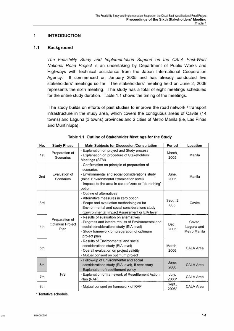
1 INTRODUCTION
1.1 Background
The Feasibility Study and Implementation Support on the CALA East-West
National Road Project is an undertaking by Department of Public Works and
Highways with technical assistance from the Japan International Cooperation
Agency. It commenced on January 2005 and has already conducted five
stakeholders’ meetings so far. The stakeholders’ meeting held on June 2, 2006
represents the sixth meeting. The study has a total of eight meetings scheduled
for the entire study duration. Table 1.1 shows the timing of the meetings.
The study builds on efforts of past studies to improve the road network / transport
infrastructure in the study area, which covers the contiguous areas of Cavite (14
towns) and Laguna (3 towns) provinces and 2 cities of Metro Manila (i.e, Las Piñas
and Muntinlupa).
Table 1.1 Outline of Stakeholder Meetings for the Study
No. Study Phase Main Subjects for Discussion/Consultation Period Location
1st Preparation of
Scenarios
- Explanation on project and Study process
- Explanation on procedure of Stakeholders’
Meetings (STM)
March,
2005 Manila
2nd Evaluation of
Scenarios
- Confirmation on principle of preparation of
scenarios
- Environmental and social considerations study
(Initial Environmental Examination level)
- Impacts to the area in case of zero or “do nothing”
option
June,
2005 Manila
3rd
- Outline of alternatives
- Alternative measures in zero option
- Scope and evaluation methodologies for
Environmental and social considerations study
(Environmental Impact Assessment or EIA level)
Sept., 2
005 Cavite
4th
- Results of evaluation on alternatives
- Progress and interim results of Environmental and
social considerations study (EIA level)
- Study framework on preparation of optimum
project plan
Dec.,
2005
Cavite,
Laguna and
Metro Manila
5th
Preparation of
Optimum Project
Plan
- Results of Environmental and social
considerations study (EIA level)
- Overall evaluation on project validity
- Mutual consent on optimum project
March,
2006 CALA Area
6th
- Follow-up of Environmental and social
considerations study (EIA level), if necessary
- Explanation of resettlement policy
June,
2006 CALA Area
7th - Explanation of framework of Resettlement Action
Plan (RAP)
July,
2006* CALA Area
8th
F/S
- Mutual consent on framework of RAP Sept.,
2006* CALA Area
* Tentative schedule.
379
The Feasibility Study and Implementation Support on the CALA East-West National Road Project
Proceedings of the Sixth Stakeholders’ Meeting Chapter 1
1-2 Introduction
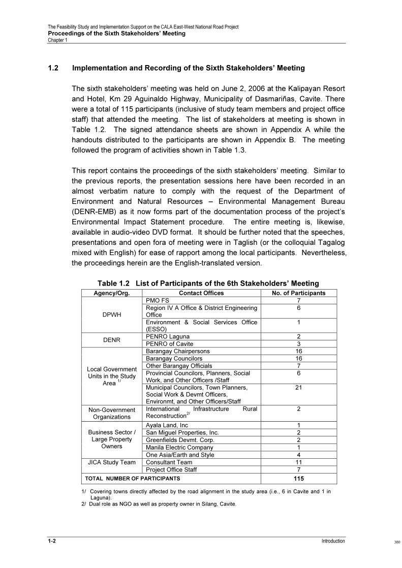
1.2 Implementation and Recording of the Sixth Stakeholders’ Meeting
The sixth stakeholders’ meeting was held on June 2, 2006 at the Kalipayan Resort
and Hotel, Km 29 Aguinaldo Highway, Municipality of Dasmariñas, Cavite. There
were a total of 115 participants (inclusive of study team members and project office
staff) that attended the meeting. The list of stakeholders at meeting is shown in
Table 1.2. The signed attendance sheets are shown in Appendix A while the
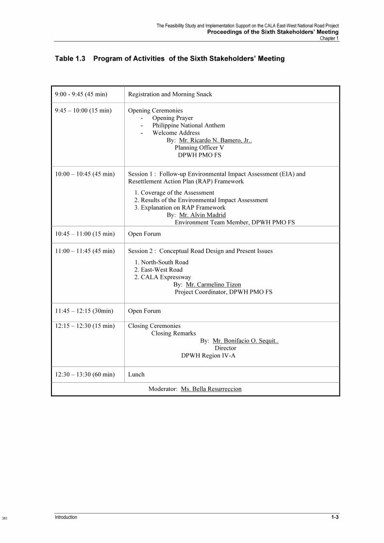
handouts distributed to the participants are shown in Appendix B. The meeting
followed the program of activities shown in Table 1.3.
This report contains the proceedings of the sixth stakeholders’ meeting. Similar to
the previous reports, the presentation sessions here have been recorded in an
almost verbatim nature to comply with the request of the Department of
Environment and Natural Resources – Environmental Management Bureau
(DENR-EMB) as it now forms part of the documentation process of the project’s
Environmental Impact Statement procedure. The entire meeting is, likewise,
available in audio-video DVD format. It should be further noted that the speeches,
presentations and open fora of meeting were in Taglish (or the colloquial Tagalog
mixed with English) for ease of rapport among the local participants. Nevertheless,
the proceedings herein are the English-translated version.
Table 1.2 List of Participants of the 6th Stakeholders’ Meeting
Agency/Org. Contact Offices No. of Participants
PMO FS 7
Region IV A Office & District Engineering Office
6 DPWH
Environment & Social Services Office (ESSO)
1
PENRO Laguna
2 DENR
PENRO of Cavite 3
Barangay Chairpersons 16
Barangay Councilors 16
Other Barangay Officials 7
Provincial Councilors, Planners, Social Work, and Other Officers /Staff
6 Local Government Units in the Study
Area 1/
Municipal Councilors, Town Planners, Social Work & Devmt Officers, Environmt, and Other Officers/Staff
21
Non-Government Organizations
International Infrastructure Rural Reconstruction
2/
2
Ayala Land, Inc 1
San Miguel Properties, Inc. 2
Greenfields Devmt. Corp. 2
Manila Electric Company 1
Business Sector /
Large Property Owners
One Asia/Earth and Style 4
Consultant Team 11 JICA Study Team
Project Office Staff 7
TOTAL NUMBER OF PARTICIPANTS 115
1/ Covering towns directly affected by the road alignment in the study area (i.e., 6 in Cavite and 1 in Laguna).
2/ Dual role as NGO as well as property owner in Silang, Cavite.
380
The Feasibility Study and Implementation Support on the CALA East-West National Road Project
Proceedings of the Sixth Stakeholders’ Meeting Chapter 1
Introduction 1-3
Table 1.3 Program of Activities of the Sixth Stakeholders’ Meeting
9:00 - 9:45 (45 min) Registration and Morning Snack
9:45 – 10:00 (15 min) Opening Ceremonies
- Opening Prayer
- Philippine National Anthem
- Welcome Address
By: Mr. Ricardo N. Bamero, Jr.. Planning Officer V
DPWH PMO FS
10:00 – 10:45 (45 min) Session 1 : Follow-up Environmental Impact Assessment (EIA) and Resettlement Action Plan (RAP) Framework
1. Coverage of the Assessment
2. Results of the Environmental Impact Assessment
3. Explanation on RAP Framework By: Mr. Alvin Madrid
Environment Team Member, DPWH PMO FS
10:45 – 11:00 (15 min) Open Forum
11:00 – 11:45 (45 min) Session 2 : Conceptual Road Design and Present Issues
1. North-South Road
2. East-West Road 2. CALA Expressway
By: Mr. Carmelino Tizon
Project Coordinator, DPWH PMO FS
11:45 – 12:15 (30min) Open Forum
12:15 – 12:30 (15 min) Closing Ceremonies
Closing Remarks
By: Mr. Bonifacio O. Sequit.. Director
DPWH Region IV-A
12:30 – 13:30 (60 min) Lunch
Moderator: Ms. Bella Resurreccion
381

The Feasibility Study and Implementation Support on the CALA East-West National Road Project
Proceedings of the Sixth Stakeholders’ Meeting Chapter 2
Opening Remarks 2-1
2 OPENING REMARKS1
Department of Public Works and Highways
Delivered By: Mr. Carmelino Tizon
For: Mr. Faustino Sta. Maria
Director
PMO-FS, DPWH
“Good morning to everyone. Our director, Mr. Sta. Maria is on leave right now. He
is in the U.S. and he will be back next week. The one who was supposed to open
our meeting today is our OIC (officer-in-charge) Mr. Bamero, but I got a message
last night that he will not be able to come. So, I said I will be overexposed but
nevertheless I have to accept to open the proceedings of the seminar.
As part of the opening remarks, I will just give you an overview of why we are here
and what we are doing here today. It all started in the Feasibility Study and
Implementation Support for the CALA East-West National Road Project with
technical assistance from the JICA through the Department of Public Works and
Highways. The study started in January 2005 and we are expecting this to be
completed in October 2006. So, this is about 4 or 5 months from now.
When we talk of feasibility and implementation support, we talk of economics,
traffic, and technical. We talk of environmental and social issues also. This is not
only a feasibility study. Included in the title is “implementation support”. So, as I
mentioned in past meetings, we have studies and studies but what about the
implementation support. So, the study team is working out how to implement the
project fully.
This is our sixth stakeholders’ meeting. It is one of the project’s commitments to
keep the stakeholders’ abreast of what is going on in the project. What should you
know about the activities of the project? When we say project, it is the project
preparation activities. I would also like to share that the stakeholders’ meeting will
let you know (as part of the stakeholders of the project) what the government is
doing.
Now, as I mentioned this is the stakeholders’ consultation regarding project
preparation activities. In DPWH, we also have stakeholders’ consultation just for
the implementation stage. This is actually part of the DPWH reform and I think this
will be initiated this month or next month. This now involves consultation during
and after the implementation of the project. We also have the consultation with the
civil society of effectiveness of road services and user engagement. What does
this mean? The department wants to relate to the civil society (not the civil society
1 The delivery of the speech was in Taglish (colloquial Tagalog mixed with English) for ease of comprehension
by the local participants. Nevertheless, the proceedings herein are translated to English.
383
The Feasibility Study and Implementation Support on the CALA East-West National Road Project
Proceedings of the Sixth Stakeholders’ Meeting Chapter 2
2-2 Opening Remarks
equated with rallies) as part of the road users, transport operators, and trucks
operators. This is the move of the department. The objective here is to engage
the citizens as road users to enhance the effectiveness of services provided by the
DPWH. The infrastructure project is given to the citizens. This is some sort of
“road-socio contract” where the DPWH has an obligation to the citizens. This is
like an agency ‘report card’ of the department to gauge the effectiveness of DPWH
in implementing projects coming from the road users or the civil society group that
are transport-related. This is another aspect of the stakeholders’ meeting that
DPWH has to undertake.
This is our Sixth Stakeholders’ Meeting. The previous fourth and fifth
Stakeholders’ Meetings had two separate venues. One in Laguna and one in
Cavite.
Today’s meeting will tackle two aspects. One will focus on project impacts based
on environmental and social surveys presented last stakeholders’ meeting. This
will be handled by Mr. Alvin Madrid. The second presentation will focus on
preliminary conceptual designs on proposed roads as well as status on initially
presented issues. This will be handled by me later.
So, we would like to request for your valuable inputs. Help us out in the
completion of this feasibility study and implementation support. Thank you very
much.”
384
The Feasibility Study and Implementation Support on the CALA East-West National Road Project
Proceedings of the Sixth Stakeholders’ Meeting Chapter 3
The First Session on EIA and RAP Framework 3-1
3. THE FIRST SESSION ON EIA AND RAP FRAMEWORK
3.1 Presentation on the Follow-up Environmental Impact Assessment (EIA) and
Resettlement Action Plan (RAP) Framework
Prior the start of this first session, the moderator proceded with the introduction of
the JICA study team members and the DPWH counterpart team members. She
then gave a brief introduction for Mr. Alvin Madrid, the environmental team leader
of the DPWH PMO FS.
The presentation started with Mr. Alvin Madrid greeting the participants. He then
went on with his explanation of each slide presentation as quoted below1.
Slide 1: (Page Title) Session 1: Follow-up Environmental Impact Assessment and
Resettlement Action Plan Framework
“Good Morning. This session covers the environmental impact assessment and
resettlement action plan and its framework. As it was introduced, the things that
will be tackled here are the results and analyses (in terms of impacts) with regards
to the gathered data which were presented in the previous stakeholders’ meeting. “
Slide 2: Today’s Topics
“So this will cover the topics on project description, framework of environmental
and social study, results of environmental impact assessment, outline of mitigation
measures for negative impacts, outline of monitoring plan, framework of RAP,
consensus building process and some updates, and the future steps for the
environmental and social concerns.”
Slide 3: (Title Page) Project Description
(shown only)
Slide 4: Study Area
“As you well know, in the last meeting, we have been talking of the project area,
which we are all familiar with. We are now still covering the Province of Cavite and
some parts of the Province of Laguna.”
Slide 5: Target Project
“The proposed roads or the target projects would be the North-South Road starting
from Bacoor and down to Silang covering 26.7 kilometers with a design speed of
60 km/h and 6 lanes with a right-of-way width of 30 meters.
1 The presentation was in Taglish (colloquial Tagalog with a mixture of English) for ease of comprehension by
the participants. Nevertheless, the proceedings herein are translated to English. .
385
The Feasibility Study and Implementation Support on the CALA East-West National Road Project
Proceedings of the Sixth Stakeholders’ Meeting Chapter 3
3-2 The First Session on EIA and RAP Framework
The second one would be Daang Hari (CALA East-West) starting from Muntinlupa
down to Tanza covering 21 kilometers. Also with 60 km/h design speed; 4 lanes;
and with right-of-way of 30 meters.
CALA Expressway would be starting at the junction of Governors’ Drive down to
Asia Brewery Exit covering 22.9 kilometers. The design speed is 100 km/hr for an
expressway. And will be composed of a 6-lane road and right-of-way of 50
meters.”
Slide 6: Current Situation (North-South)
“These are some pictures of the current situation in the different portions of the
North-South Road. So we have situations at the coastal area at the Bacoor area,
the New Molino Boulevard, and some river crossings. The alignment will traverse
near the La Salle Medical Center and the controversial Citta Italia.”
Slide 7: Current Situation (Daang Hari)
“For the current situation down in Daang Hari, we all know that the bridge is nearly
finished and this will connect to the Aguinaldo Highway. And the project will
extend to Tanza. So, this is the current or present situation down in Daang Hari.
So, we have the usual traffic flow shown here. We have some river crossings and
some open areas.”
Slide 8: Current Situatioon (CALA Expressway)
“I am presenting now the CALA Expressway. We have pictures here of deep
ravine and river crossings and some open areas and the usual traffic in some parts
of Silang and around some parts of the Tagaytay-Sta. Rosa Road.”
Slide 9: Main Rivers
“Also, we have some main rivers in the project area, which is comprised of the
Ylang-ylang river, the Rio Grande, the Canas and the Imus River. We have rainfall
gauges in these areas and water level gauges in these areas (as shown on map).
These are used to monitor water levels or flood levels. “
Slide 10: (Title Page) Framework of Environmental and Social Considerations
Study
(shown only)
Slide 11: (Chart of Framework)
“This is the flow of the study, which most of us are familiar with. We are at this
stage. We are now forming the Resettlement Framework and the Preliminary RAP,
which is in conjunction with overall study for Environmental Impact Assessment.
When this report is completed, it will be submitted to EMB or the Environmental
Management Bureau of DENR for their assessment. And, hopefully, we will
secure their ECC. So, we are on the sixth stakeholders’ meeting. And we have
386
The Feasibility Study and Implementation Support on the CALA East-West National Road Project
Proceedings of the Sixth Stakeholders’ Meeting Chapter 3
The First Session on EIA and RAP Framework 3-3
two more left and we will discuss further the feasibility and the environmental
studies of the project.”
Slide 12: Stakeholders’ Meetings
“So, these are the schedules we had and the schedules in the future for our
stakeholders’ meetings. Next schedule for our meeting is early July and early
September for the last stakeholders’ meeting.”
Slide 13: Environmental and Social Considerations Study
“For the environmental and social considerations study, previously we discussed
the environmental baseline and social surveys we have conducted. Today, we will
discuss impacts assessments and some mitigation measures for significant and
negative impacts. We will also present a monitoring plan and the framework for
the Resettlement Action Plan (RAP).”
Slide 14: Environmental Items for EIS
“For the environmental items, we covered the effects on physical environment
such as the effects on: land, water, air and noise. For the biological environment,
we covered the terrestrial ( or the flora and fauna) and the conditions of the fresh
water . For land use, we have the land use and zoning, aesthetics and visual
effects, the archaeological and historical sites in the area, and the socio-cultural
and economic aspects. Of course, we studied the areas’ population, economic
activities, labor and employment, housing and social services, and so on and so
forth. All these are the basic requirements for the establishment of the
Environmental Impact Statement.”
Slide 15: (Title Page) Results of Environmental Impact Assessment
(shown only)
Slide 16: Environmental Impacts during Construction (1)
“For the physical environment, we talked about environmental impacts. These are
the predicted environmental impacts on land: terrain modification; soil and
weathered rock displacement and erosion; and siltation. These are the major or
significant impacts wherein there will be land movement or the earth works. So
terrain modification, we have some areas to be flattened or filled up for the design
of the road and some for the flyovers or bridges. So these are the possible
impacts on the areas wherein erosion and roack displacement will occur. Also
some slope destabilization for new cuts. So for relatively high elevation areas, we
need to have some cuts. These cuts will have residue and the soil will be used to
fill some low areas in the project area. The slope destabilization will be of the
moderate impact.
Changes in river water quality pertain mostly to during construction. So, we have
some siltation and debris deposited in the river, which will make the river quality
rather poor during the construction stage.
387
The Feasibility Study and Implementation Support on the CALA East-West National Road Project
Proceedings of the Sixth Stakeholders’ Meeting Chapter 3
3-4 The First Session on EIA and RAP Framework
On air, there will be increase in particulates and gaseous emissions during
construction (produce a lot of dusts) and the equipment will contribute to the fuel
emissions. And noise will be increased during construction.
On biological environment, there will be loss, disturbance and damage to existing
vegetation. So, we will have tree cutting and some areas of agricultural use will be
covered and used as roadway.
On freshwater, there will be local aquatic habitation alternation and temporary
displacement of species. So in these items, we focus on land and water which
have greater impact relative to the others.
The next presentation will be tackling on the mitigation measures. So, please take
note of these impacts.”
Slide 17: Major Crossing Point at River/Creek
“So, these are the major crossings at rivers/creeks. Daang Hari would be having a
lot of bridges because the terrain and the river formations are on the north-south
trend. So the east-west direction of Daang Hari will cross so many rivers in the
project area. The North-South Road will also have a number of bridges and
flyovers. Also similar to Daang Hari, the CALA Expressway will have a lot of
bridges constructed for an east-west trending road.”
Slide 18: Environmental Impacts during Construction (2)
“These are the impacts during construction on land. For the impact on
archaeological and historical sites, I think we are relatively far from the historical
sites. On the socio-economic impact, there will be total or partial loss of land. This
is a very sensitive subject. There will be loss of farm area, properties and crops,
dislocation and loss of income due to right-of-way acquisition. These are the main
impacts also with the dislocation of families. The moderate impact is the increase
in livelihood and business opportunities.
The other impacts of moderate degree are the increase in employment
opportunities; potential health, sanitation and safety problems; and increase in
solid waste during construction. All of these impacts will be mitigated but we
would rather center our focus on the main negative impacts.”
Slide 19: Number of Directly Affected Households
“These are the number of affected families through out project area. A total of 667
families in Cavite and Muntinlupa is a total of 66 families. This is an estimate.
There may be a shift in the alignment in DH2 or the Daang Hari alignment in
Muntinlupa. This will be updated and we will inform you of the updates during the
next stakeholders’ meeting.”
388

The Feasibility Study and Implementation Support on the CALA East-West National Road Project
Proceedings of the Sixth Stakeholders’ Meeting Chapter 3
The First Session on EIA and RAP Framework 3-5
Slide 20: Environmental Impacts during Operation (1)
“During the road operation, these are the impacts. Again, for land, there will be
erosion at the discharge points of the road storm drains. For water, there will be
water inflow at the discharge points of the road storm drains. For air, there will be
increase in particulates and gaseous emissions because in operation we expect
very high volume of traffic that will use our roads. Likewise, there will be an
increase in noise levels.
For land, there will be some changes in the landscape.”
Slide 21: Future TSP Level (2015)
“Talking about noise, air and air pollution or some air quality increases, this
illustration presents some data that we gathered from the previous activities of air
quality measurements plus we integrated Metro Manila data on air quality and
average traffic volumes. So, we have an increasing trend. As the volume of traffic
increases, the reading of Total Suspended Particulates also increases. This point
is Daang Hari. This is the projection for year 2015. Daang Hari will have an
approximate of 65,000 passenger-car units (pcu). That would be equivalent to 170
TSP reading. This red line is the standard of DENR, which is set at 230. So, it is
below even at year 2015. CALA Expressway is also below the standard at an
approximate reading of 200 and the North-South Road would be a little below the
standard at 220. So, these are the exact figures of the model for the approximate
estimation of TSP levels versus the traffic volumes.”
Slide 22: Environmental Impacts during Operation (2)
“For the socio-economic aspects, for the housing and social services, there will be
a regional severance. This is equated to regional divide. We will illustrate this
impact later.
Infrastructure and public utilities: the improvement in the access to public utilities
and services, some existing access roads and access of people going to different
places will be moderately affected.
Accidents: increase in traffic accidents are seen because of the introduction of
new roads and also in the population and activities around the new constructed
roads. Mitigation measures - you are all familiar with safety and traffic
management so this is considered an important mitigation for accidents.”
Slide 23: Image of Regional Severance
“This is an image or simple illustration of a regional severance or regional divide
situation. For example, these blocks are groups of people inside a community
wherein people travel from place to place in different directions like going to
market, hospitals, work, pleasure or what have you. So this is the human flow.
The road is constructed and divides the community. It will pose some hindrances
389
The Feasibility Study and Implementation Support on the CALA East-West National Road Project
Proceedings of the Sixth Stakeholders’ Meeting Chapter 3
3-6 The First Session on EIA and RAP Framework
for people to travel for their usual activity. This is a case of a regional severance
or regional divide.”
Slide 24: (Title Page) Outline of Mitigation Measures for Negative Impacts
(shown only)
Slide 25: Mitigation Measures for Negative Impacts – For Directly Affected
Households
“For the mitigation measures for these impacts, for the directly affected
households, the preparation of the Resettlement Action Plan is now ongoing. And
it is focused on fair compensation. Do not be misled that every household will be
entitled to this kind of house. This is one of the issues in Citta Italia.
Fair compensation is the issue of replacement of the structure and the acquisition
of the land is also an issue for the preparation of the Resettlement Action Plan.
Later, we will be presenting to you the framework or the basis for the entitlements
for the affected families.”
Slide 26: Mitigation Measures for Negative Impacts – For Air Pollution and Noise
Level Increase
“For air pollution and noise level increase, mitigation measures for noise would be
planting of trees along side the roadway to break sound waves before reaching the
built-up areas. This is one of the examples. Usually, DPWH plants fast growing
trees. This will be well planned by our designers.
For the dust emissions or the smoke and dust emissions on the streets, currently
MMDA has this equipment of the street sweeper. This is street sweeper
equipment used by MMDA to maintain cleanliness usually in EDSA.”
Slide 27: Mitigation Measures for Negative Impacts – For Regional Severance
“For regional severance or divide, the project is assigning some pedestrian
crossing at-grade or in the form of flyover for areas that would need to transport
people from one place to the other side of the regional divide. It is also for them to
have continued activities after the construction.
So, some of our road sections would be over existing intersections and pedestrian
crossing might be designed under the newly constructed facility.”
Slide 28: (Title Page) Outline of Monitoring Plan
(shown only)
Slide 29: Environmental Monitoring Plan
“We have to have a program to monitor all these mitigation measures to check
whether mitigation measures are carried out by your DPWH components and also
390
The Feasibility Study and Implementation Support on the CALA East-West National Road Project
Proceedings of the Sixth Stakeholders’ Meeting Chapter 3
The First Session on EIA and RAP Framework 3-7
if these mitigation measures are effective to handle these impacts. So, the
contractor will be handling these slope profile and signs of instability. The
responsibility could be on the DPWH/DENR/MMT of the multipartite monitoring
team, which is composed of local government representatives and DPWH (the
proponent) to monitor these levels of impacts. So, you are involved in the
monitoring of the impacts of said project during and after construction.”
Slide 30: (Title Page) Framework of Resettlement Action Plan
(shown only)
Slide 31: Summary of Relevant Policies on Land and Resettlement
“Now for the resettlement framework, we have been guided by several laws for
resettlement. This is a summary of the laws and regulations that would be used as
a guide to establish the Resettlement Action Plan for this project.
First, we have Republic Act 7279 or UDHA. This law is on the welfare of providing
shelter for squatter families but it also advocates that no squatter should be living
in danger zones like coastal roads, river banks, etc. It advocates the oberservance
of just and humane manner of eviction and demolition. So, we could not just evict
people without notice, without consultation, and so on.
The land valuation and compensation is guided by Republic Act 8974. It
discusses and guides on the mode of land acquisition and procedures on
expropriation and compensation.
For resettlement options, Republic Act 6026 provides options and assistance to
squatters (informal dwellers).
Compensation for lost crops based on the Comprehensive Agrarian Reform Law
or the RA 6657: compensation for lost crops and displaced tenants and settlers is
provided.
For eminent domain, we have Circular No. 35 and Republic Act 7160 of 1990
which allows government to exercise eminent domain on payment of just
compensation.
Community participation is encouraged and development initiatives in Article III,
Section 10 of the Philippine Constitution of 1987.
Lastly, gender and development: RA7192 is mainstreaming gender concerns in
development projects. So, we are concerned with our women, our youth, our
children, etc. Together, we will devise some manner of activities for their
development along side the development of the overall community.
So, this now the framework for the Resettlement Action Plan.”
391
The Feasibility Study and Implementation Support on the CALA East-West National Road Project
Proceedings of the Sixth Stakeholders’ Meeting Chapter 3
3-8 The First Session on EIA and RAP Framework
Slide 32: Project Resettlement Framework – Payment of Land
“Payment will be given to registered owner of the land with Transfer Certificate
Title (TCT) as proof of ownership. A tax declaration receipt is not proof of
ownership.
Tax declaration may ripen into full ownership upon application for titling with the
DENR, provided the said parcel of land is classified as alienable and disposal land.
Only improvements will be compensated.
All land titles are registered with the concerned government agencies. The DPWH
researchers called ROW agents will verify land titles subject for compensation.
Payment will be done after a process of verification. Verification has to be done
because some have fake titles. It will be closely followed by the DPWH right-of-
way agents.
The price may be negotiated. The last recourse of DPWH is a court case in the
event the landowner is not amenable to sell his property at the offered price.
Some steps will be taken by the proponent – the DPWH to consult you and
affected families in every step of this proceeding.”
Slide 33: Project Resettlement Framework - Payment of Structure; Compensation
of Trees and Crops
“Payment of Structure: During the feasibility study, the directly affected
households and their structures will be identified based on the road alignment. In
our previous activities, we identified houses or structures along the roadway -
inside the right-of-way and a buffer zone on both sides of about 5 to 10 meters.
The purpose of including houses in the buffer zones is that we are anticipating or
expecting some minor movement or modification of the alignment. So, we know
the approximate number of houses that can be affected in cases of modifications.
In the detailed engineering phase, the houses will be photographed. Actually, we
have photographed them already. But in the detailed engineering phase, we will
photograph them again and we will be tagging them and we will have a final list of
these affected structures. Final structures during the detailed engineering would
not only include houses but it will also include business establishments, buildings,
or even barangay hall in the case of Salitran, even electric posts, and also trees or
significant vegetation.
The structure will be paid based on the replacement value as of the designated
cut-off date. So, if the cut-off date is 2007, prices will be 2007 base prices. That
includes materials and labor. So, even if the structure was built in 1960 or 1970,
prices estimation will be based on 2007 or upon designated cut-off date.
392

The Feasibility Study and Implementation Support on the CALA East-West National Road Project
Proceedings of the Sixth Stakeholders’ Meeting Chapter 3
The First Session on EIA and RAP Framework 3-9
Compensation of Trees and Crops: The owners of trees and crops will be
compensated based on the values in the provincial and/or municipal assessor’s
office.
There may be trees that have no listed value in the provincial or municipal
assessor’s office. In these cases, the values of trees and crops in the Department
of Agriculture or the Department of Environment and Natural Resources will be the
bases of valuation. Usually, they cost the trees by type or kind and age. Some
fruit trees are estimated on the value they produce in a span of 5 or 3 years.
Slide 34: Project Resettlement Framework – Partial Effects on Structures and
Lands
In cases where we have partial effects on structures, if only one-fifth (20%) of a
house will be affected and still be livable, then, only the affected portion of the
house will be compensated. If your veranda is affected then only your veranda will
be costed because your house is still livable. But if your ‘sala’ is affected, you will
not wake up one morning and be run over by a bus. So, your whole house will be
paid. That is the simplest description of a livable house. What is livable is that only
one-fifth is affected and you continue your activities inside the house safely.
This is also true with partially affected lands. If the properties have been impaired
in any way by the project such that they are no longer livable or economically
viable to sustain existing usage, for example, offices or buildings, then the whole
property will be compensated.
Portions of land actually used or impaired because of the project will be
compensated by the project. The original title will be sub-divided to reflect the
portions paid by the government and new titles will be issued in favor of the
government and the owner.
Slide 35: Project Resettlement Framework - Relocation
Relocation is one of the options of households. So, in our surveys, we ask the
affected or possible affected families if they are in favor of a relocation site; if they
want to go back to their home town or province; or if they want to be compensated
and they will choose their own place to stay. So, this relocation is one of the
households’ options. DPWH will supply the necessary information about the
directly affected households to the municipality based on the data gathered during
the various stages of the project. As I have said, we have conducted this in the
early stage of the feasibility (in the environmental study) together with the counting
of the houses. We interviewed personally the household head but unfortunately
we are also unlucky to proceed with some interviews because the owners of the
structures refused to be interviewed like in Citta Italia.
393
The Feasibility Study and Implementation Support on the CALA East-West National Road Project
Proceedings of the Sixth Stakeholders’ Meeting Chapter 3
3-10 The First Session on EIA and RAP Framework
The municipality as part of its counterpart for the project will then prepare a
relocation site based on the actual number of households in their municipality who
opted for resettlement in this project.
So, the purpose of the social survey is not only for us. It is also for vital
information for the municipalities and also for their cost estimator to determine the
size of lots for the affected families because we have some entries here on the
size of the family. So, the average size of the lot could be established and the
average paying capacity of each household could be determined because we also
ask their monthly average income.
There will be no forced eviction without court order.”
Slide 36: Project Resettlement Framework – Relocation; Alignment
“The next step will be disclosure activities where dislocated households will be
informed about their relocation options and compensation. The objective of this
disclosure is to avert the need for forced eviction by providing acceptable
compensation. What is happening is some people would get their compensation
and sell their right or make business out of it or take the money and leave. So,
during the consultations, we clarify and get the exact information from households
how much are they able to pay for the lot. Also, at the start of the barangay
consultation, we clearly say that there is no free relocation site. Payment for
amortization of relocation lots would be defined by their capacity to pay.
The foreign funder will not release any amount for the construction unless DPWH
has resolved the right-of-way issues and has paid the affected owners 100% of the
compensation, to be compensated at least a month before actual construction can
begin. This same close because there are some negotiations on some quarters of
the project. So, it is a very close limit before construction. It should be settled or
else we go into court which takes months or years and it will delay the overall
project and also affected persons would spend for attorney’s fee and a lot of time
has been wasted. In our effort, we will be consulting the affected families and also
consult the local leaders to discuss this matter with the affected families.
As a rule, the road alignments proposed by DPWH will try to avoid structures
particularly those providing public services such as schools and hospitals.
Proposed road alignments veered away from structures that are very expensive
such as main transmission lines for electricity. So, if you will notice, the design of
the North-South is further away from the main electric posts. If you are looking
northward, it is on the right side of Aguinaldo (the huge metal-cased posts there).”
Slide 37: Project Resettlement Framework – Public Hearing; Land Valuation
“Public hearing and barangay consultations required by the DENR as part of the
EIA process were undertaken to inform the affected residents and to
394
The Feasibility Study and Implementation Support on the CALA East-West National Road Project
Proceedings of the Sixth Stakeholders’ Meeting Chapter 3
The First Session on EIA and RAP Framework 3-11
elicit the views, concern and issues on the proposed project. We have done
around 72 barangay consultations and this is the sixth stakeholders’ meeting. And
we are now in the process of making the Environmental Impact Statement in which
a public consultation or public hearing might be required by EMB so that we can
acquire the ECC.
In the context of Mr. Tizon’s opening remarks, the DPWH (not as a requirement of
DENR) will start to consult formally with constituents on the proposed projects to
be carried out by DPWH.
Land Valuation: If the offered price for the properties is perceived to be low by the
landowner, he can ask for a better price. DPWH will commission an independent
appraiser to determine the replacement cost. As a last recourse, DPWH can file
expropriation through the power of eminent domain of the state. However, to
prevent this legal eventuality, consultations are being undertaken to thresh out
issues and concerns of directly affected households. So, during valuation of land,
there will a lot of negotiation to be undertaken by DPWH to avoid expropriation. “
Slide 38: Project Resettlement Framework – Compensation of Tenants;
Conversion of Agricultural Land to Road Use
“Compensation of Tenants: The legal tenant of the land will be paid based on the
Comprehensive Agrarian Reform Law.
In cases wherein the tenant will be dispossessed from the land that he tills, the
prescribed compensation to be given to the tenant is equivalent to 1 year income
from the harvest based on average of past 3 years which is not less than P15,000
per hectare. In a separate study by Asian Development Bank, land preparation is
of a separate costing.
Conversion of Agricultural Land to Road Use: This is a road project of DPWH,
which entails the construction of a road passing through land with various uses
such as agricultural, residential, commercial and industrial. It is submitted that to
build a road in these lands with various uses does not require the usual conversion
processes as enunciated by the Comprehensive Agrarian Reform Law.”
Slide 39: Project Resettlement Framework – Inherited Land; Transparency
“Inherited Land: DPWH will compensate the heirs with legal proof of land
ownership.
Transparency: The residents will be given updates during the various stages of
the project. The team, through consultations with possible affected households will
find out the best road alignment.
395

The Feasibility Study and Implementation Support on the CALA East-West National Road Project
Proceedings of the Sixth Stakeholders’ Meeting Chapter 3
3-12 The First Session on EIA and RAP Framework
In the detailed engineering stage, the households to be affected will be positively
identified. Before the actual relocation, consultations and coordination will be done
with the affected parties, barangay, and municipal officials.
Disclosure meetings will be held, which will provide detailed valuation for the land
or structure to the directly affected owners.
If you have comments, please raise them later for the open forum.”
Slide 40: (Title Page) Consensus Building Process for Implementation of the
Proposed Projects – Update: (Issue on Resolutions by LGUs)
(shown only)
Slide 41: Status of Resolutions (Cavite: total 39 brgys)
“Going into the consensus building process for the implementation of the proposed
projects, for your update, ladies and gentlemen, these are the barangays that we
have received barangay resolutions from. These are also the municipalities that
have not submitted yet because it is being consulted yet with the Sangguniang
Bayan. We now follow up these resolutions from the respective municipalities.”
Slide 42: Status of Resolutions (Cavite): continued
“We have Barangay Tibig in Silang still lacking.”
Slide 43: Status of Resolutions (Laguna: 3 brgys & Metro Manila: 2 brgys)
“And Barangay Malitlit for Laguna and Barangay Poblacion of Muntinlupa (we have
presented to the Infrastructure Cluster in February 22 in Muntinlupa City). For
Laguna, we are still waiting for your endorsements or resolutions. “
Slide 44: Next Steps for ESC
“Finally, the next steps for the environmental and social considerations would be:
(1) The Complementation of the EIS or the Environmental Impact Statement that
we will present to you in the next stakeholders’ meeting;
(2) Further deliberation and improvement of the RAP (or Resettlement Action Plan)
which we are now trying to update all details and based on the policy
framework. .We will present to you in the next stakeholders’ meeting some
computation of entitlements and also criteria of who will receive what in the
next stakeholders’ meeting;
396

The Feasibility Study and Implementation Support on the CALA East-West National Road Project
Proceedings of the Sixth Stakeholders’ Meeting Chapter 3
The First Session on EIA and RAP Framework 3-13
(3) Of course, the next stakeholders’ meeting will be early July and the last will be
early September.
Thank you very much.”
3.2 Open Forum
Ms. Bella (the moderator) thanked Mr. Alvin Madrid and declared the start of the
open forum and requested requested the participants to raise their questions. In
addition, Mr. Tizon came forward and encouraged the participants to raise their
concerns as it will be the basis for the study team to address and it will be
integrated in the study activities.
As there was no question from the participants, Mr. Tizon stressed on the issue of
the barangay, municipal and provincial resolutions (in the checklist) that are still
pending. He pointed out that most barangays have complied with their resolutions
thereby giving an indication the barangays are supportive of this undertaking. The
study team is still awaiting the municipal resolutions. Mr. Tizon informed the
participants that officials of the local government units were invited in the
stakeholders’ meeting to gain more information on the project so that they can
discuss this in their Sangguniang Bayan (SB) meeting. But it seems they are busy
so the study team is willing to present the project to each SB, if needed, as a basis
for the issuance of the municipal resolution.
Ms. Bella informed the participants that they can still raise their questions in the
next session.
397
The Feasibility Study and Implementation Support on the CALA East-West National Road Project
Proceedings of the Sixth Stakeholders’ Meeting Chapter 4
The Second Session on Conceptual Road Design 4-1
4. THE SECOND SESSION
4.1 Presentation of the Conceptual Road Design and Present Issues
The moderator gave a brief introduction for Mr. Carmelino Tizon of the DPWH
PMO FS. Mr. Tizon then took over and began his presentation of the CALA
conceptual road design and the present issues identified.
Slide 1: Session 2: Conceptual Road Design and Present Issues
“I will be presenting to the body, the conceptual road design and the present
issues. We are planning this feasibility study, our projections here, for the next 30
years. Perhaps we are no longer here. But our children, our grandchildren will still
be here in Laguna and Cavite. But during the implementation hopefully, perhaps
we are still here.
If you will just take note, the present situation now in our area – Laguna, Cavite –
we see the traffic congestion, Aguinaldo Highway, South Luzon Expressway, even
bound to Los Baños. In fact, here in Cavite, I got to know about this traffic flow
scheme, “buhos system”, that there are times for all outgoing vehicles, and there
are times for all incoming vehicles. They say that is where we are unique. That is
one way of the provincial government addressing the situation, of course, with the
DPWH and perhaps the LGUs also.
For the past decade, part of the congestion problem, is the growth rate. In terms
of the population in our area, the rate is something like six percent per annum.
That is big. Our national average is something like 2.5 percent per annum only.
Our study area, that includes Las Pinas and Muntinlupa, our population is
something like 3.2 million inhabitants.
The Metro Manila at present is something like 8-10 million per day. Our
projections for Cavite-Laguna area, come 30 years from now, is eight million
population. When we reckon this, it is almost the same with the population of
Metro Manila. Look what will happen to Cavite and Laguna if we don’t have
infrastructure projects, especially roads.
That’s why at present we are already experiencing this traffic problem, this
population problem. Just open one road and real estate developments follow.
Example of which is the Daang Hari, it was open and then subdivisions sprouted
like mushrooms.
The DPWH on this matter, is very much concerned. That is why this study is being
pursued of course, with the assistance from the Japanese Government, to really
address the present situation in the area, much more for the future.
399

The Feasibility Study and Implementation Support on the CALA East-West National Road Project
Proceedings of the Sixth Stakeholders’ Meeting Chapter 4
4-2 The Second Session on Conceptual Road Design
Okay, so that’s more of a backgrounder. So we got to think, ‘what should we really
do with our beloved provinces?’”
Slide 2: Project Roads
“These are the priority area that we are talking about in this particular undertaking.
Before, these were plenty. We have gone through a selection process, because in
the master plan really a number of roads were identified for that area but because
of the limitation of the scope, we have identified priority projects. These were the
ones mentioned during the first, second, third and fourth stakeholders meeting.
This is the north-south backbone, coming from toll plaza of Manila-Cavite
Expressway, crossing Talaba. It will cross here at Saint Dominic. This red one. It
will run parallel to Aguinaldo Highway, onwards to Daang Hari then onwards to
Governors’ Drive and farther South to Silang.
Molino Road is a national secondary road – this is already decongested also.
Aguinaldo Highway -- main arterial road, decongested also. So the objective of
this red line, the North-South Road that we are talking about is to decongest
Aguinaldo Highway.
Another priority project is the greenline. This is what we call the Daang Hari. This
is the one recently opened, up to the Zapote-Alabang Road, and then it will go
farther up to Tanza.
This proposal is to extend the Daang Hari up to South Luzon Expressway. And
then, we have also proposals to address the congestion problem of the South
Luzon Expressway, of coming up with the CALA Expressway, from… this blue line,
which will be located south of Governors Drive, crossing here in Tagaytay-Sta.
Rosa Road, Aguinaldo Highway, onwards to Governors Drive. So these are the
projects, priority projects that we intend to implement for this Cavite-Laguna area.
Just to give you an overview of the magnitude of the cost requirement, the NS1,
this is about 27.2 kilometers. Our initial estimate of the cost here is about 5.7
billion pesos. We are no longer talking of millions, billions already.
And then for the Daang Hari, starting from this point up to this area. This is about
24 km. The estimated cost is 2.4 billion.
And this CALA expressway, the total length is 22 km and costing about 7.8 billion.
So overall, the total length that we are proposing in Cavite-Laguna area is about
74 km. of a total of 15.9 billion pesos. Our proposal for this Cavite area and
Laguna is big just to address the congestion.”
Slide 3 North-South Road
400
The Feasibility Study and Implementation Support on the CALA East-West National Road Project
Proceedings of the Sixth Stakeholders’ Meeting Chapter 4
The Second Session on Conceptual Road Design 4-3
“North-South Road. This is it. We are proposing here the 30 meters right-of-way.
That means, we are proposing here a six-lane road. That is six lanes. Then we
will allot 2.25 meters for the shoulders (on both shoulders), plus we are going to
put up a service road. It is either a two-lane service road, or a one-lane service
road, design speed, as already mentioned a while ago is 60 kilometers per hour.
Number of lane is six lanes. Road right-of-way requirement is 30 meters.”
Slide 4 to 8: North-South (N-S) Road (Satellite Images)
“This is one satellite image. This road will pass this curve in Manila-Cavite Coastal
Road. We will put a viaduct here. We will come up with a toll plaza here. Then
that will go down here where St. Dominic is situated, fronting the Tropical (a food
chain). Then, now we are going to make use of the new (not rather new since
partially it is being used already) the national Molino Boulevard, as we call it, which
is parallel to Molino Road, and the Aguinaldo Highway. So, it will go farther. This
is parallel to Aguinaldo Highway. SM Bacoor is here. So this will be a fly-over.
And then some minor bridges. Toll plaza – we are going to put up a toll plaza.
Then it will go farther, this is part of the North-South, this is the Molino Boulevard.
This Molino Boulevard now curves towards Molino Road.
Now our project is this one, westward. And it crosses the Citta Italia (subdivision).
This was the one mentioned earlier that has a problem. However, there has been
some initial discussions, I think with the developer of Citta Italia on how really to
address this problem. Our Japanese engineers made a compromise on a better
alignment, such that there will be lesser affected persons or houses.
Citta Italia is a big upper middle class development in the area. So this has now
being worked out. So our proposal here on crossing the Citta Italia area is, there
is a proposal to put up a fly-over, passing through a private property, not owned
actually by Citta Italia. Citta Italia now was placed in the middle.
Then it will go farther, towards the junction of Daang Hari Road, the one near the
SM Bacoor. Perhaps, there now only 300 meters left unfinished, and one major
bridge that is being constructed by the DPWH Region IV-A. Actually this is already
being used, using the dike road that’s why there has been many coming from
Aguinaldo Highway that passes Daang Hari.
When you arrive at this area, on the other hand, I think this will traverse the One
Asia property, we will be coming up with toll plaza again. Then it will go farther
here in Salitran-Salawag Road, we will put a fly-over onwards to area where the La
Salle Medical Center is situated -- another fly-over project, near Walter Mart, then
will now cross Aguinaldo Highway. We will put another fly-over, leading to
Westside. They no longer let is pass the eastside because it will hit Shoemart.
We will go to the Westside, here we will also put a middle structure, at the back of
the Robinsons Dasmariñas, at the intersection of Governors Drive, that of Palapala
401
The Feasibility Study and Implementation Support on the CALA East-West National Road Project
Proceedings of the Sixth Stakeholders’ Meeting Chapter 4
4-4 The Second Session on Conceptual Road Design
Junction. Then onwards, comes the Governors Drive, then onwards, terminating
here in the proposed CALA Expressway, west of Silang. So if Aguinaldo Highway
is here, here is the Silang area, this is the north diversion road, it is on the left side.
So this is part of the north-south backbone. Arriving at this intersection, there is a
proposal to come up with an interchange. Because on this left side here comes
what we refer as the CALA expressway.”
Slide 9: Bus Stops on N-S Road
“Our design for the North-South Road is unique. In fact, this was the one identified
in the earlier stage what we call the Busway alignment. The concept of this
Busway is unique. This is a toll facility. There is a toll road but there is a provision
for bus stops.
This means bus will be allowed along the expressway, and they have area
dedicated for designated bus stops. This shows the cross-section of that busway.
This is the midline of the expressway, we are talking here of six lanes. Buses will
exit here and this is where the bus stop will be located. It is like there is an
intermodal facility. This means the expressway now will be provided with bus
stops, but the arrangement here is it will be a controlled. Controlled means there
will be bus companies that will be allowed to use expressways. Do you know
why? So as to avoid also the congestion because you know that buses stop
anywhere although there is designated bus stop.
This busway, these are the identified, meaning there are provision for bus area,
bus will stop here, then exit at the gate, then there are also other mode of transport
waiting at the designated area. It could be jeepneys. It could be tricycles. It could
be everything, and taxis outside the expressways. So the design is unique,
expressway with bus stop. We haven’t seen this in the Philippines. This is the first
of its kind. So these are the selected bus stop in the area. As I said this is more of
a intermodal transport mode.”
Slide 10: Daang Hari Road
Daang Hari. Our proposal for Daang Hari is 21 km., 30 meters right-of-way. It’s a
four- lane. This area here. But we will take note here in the existing Daang Hari,
there are a number of sharp curves, that when the time comes when this is open
up to Aguinaldo Highway, we should avoid accidents there. So, one of the
recommendations of the study is to correct the sharp curves. Because we are
talking here of 60 kilometer per hour. If you will navigate on the sharp curves, you
are running at 20 because it is too curvy or wavy. “
Slide 1111 ttoo 1144:: Daang Hari (Satellite Images)
“This is the proposal for Daang Hari (four lanes). As I said, it will traverse
Muntinlupa then onwards to Tanza.
402

The Feasibility Study and Implementation Support on the CALA East-West National Road Project
Proceedings of the Sixth Stakeholders’ Meeting Chapter 4
The Second Session on Conceptual Road Design 4-5
This is Molino Boulevard. This is operational now. The proposal it to extend the
existing road up to South Luzon Expressway on the east using the National Bilibid
Prison (NBP) property. The study team made representation with the NBP
through General Vinarao. This is a government-owned land. “
Slide 15: CALA Expressway
“We start first with this area here in South Luzon Expressway. This is the
Tagaytay-Sta. Rosa Road.”
Slide 1166 ttoo1199:: CALA Expressway (Satellite Images)
“We were initially proposing this particular alignment which is south of Sta. Rosa-
Tagaytay Road. However, now we have a problem. Because situated here are
the Georgia Club, the Quiros Properties. Then, eventually we learned that the site
of the University of Santo Tomas is also here. Apparently, they already
commissioned Palafox firm to design their school campus.
And situated here also are the property of Lucio Tan, the Greenfield property as
well as the Landco, a realty corporation.
This area here is being said as the La Residencia. There lie also a certain sugar
development corporation, the Hacienda Sta. Elena, and a golf course.
So we are working originally on this alignment, now we shifted towards farther
south and then if we can remain here in Asia Brewery, the ABB-Greenfield (as we
have originally aligned).
For your information, with the permission of Buddy Tan, representative from Ayala,
Ayala is putting up something here. What we call this “spine road”. The centerline
of which is here, somewhat like that. So with that Ayala development, we will have
problem somewhere this intersection. Initially they will make it a rotunda. But
eventually our team is proposing an interchange.
The alignment will also pass the West Grove onwards to Aguinaldo Highway. We
already have a proposal here for a fly-over. This is their old national road. Then
farther east is the Silang-Aguinaldo Junction. Arriving at the intersection with the
North-South, we are proposing here an interchange. Then it will pass through
west of this First Cavite Industrial Estate (FCIE). Then terminates at Governors’
Drive, the alignment being somewhere in the middle of Purefoods and FCIE.
So that is the CALA expressway.”
Slide 20: Major River Crossings Along Proposed Alignment
“These are the major river crossings that we study team have identified along the
three road projects being considered priority by the study team and by the
stakeholders for the area. So these are the major river crossings.”
403
The Feasibility Study and Implementation Support on the CALA East-West National Road Project
Proceedings of the Sixth Stakeholders’ Meeting Chapter 4
4-6 The Second Session on Conceptual Road Design
Slide 21: Example of River Cross Section At No.1 along CALA Expressway
“This on the other hand is the proposed structure, the engineering intervention
when the alignment passes a river crossing section. This is the flood level, this
blue one. And then there is a free board that is 1.5 meters, that is where the
structure will be placed. The study team has also considered to use as much as
possible the easement of the river, so as to minimize the road right-of-way
requirements.”
Slide 22: Next Steps (For Project Implementation)
“What do we still have to do? Preparation and review of memorandum of
understanding between NDC-PIC -- this is the National Development Corporation
and the Philippine Infrastructure Corporation with DPWH, of course with
assistance of the study team. Why does NDC come in here? Because we are
thinking here, as mentioned earlier we are talking here of magnitude of cost,
something like 15.9 billion. DPWH can’t afford this. So we need private sector
also. So we are working this out with NDC, for it to look for some private partners
to construct some of the proposed projects in the area.
The first that we are referring here is that NS1. This is the viaduct from Cavite
Coastal road towards Saint Dominic. So it will cross there. Of course, the DPWH
is there when it will be constructed. It will eventually or initially decongest this
Talaba area. But it will be operated a toll. You will pass through the viaduct. You
will pay your toll. So at least, it will initially address the congestion in Bacoor, at
Talaba area. So that’s one of the initiatives that we are holding, we are negotiating
with the private sector, through NDC.
Secondly is the enactment of the department order by the DPWH -- that the
existing Molino and Daang Hari roads be converted into a national road. This is
the proposed upgrading and widening.
We have already made representation on this matter with our counterpart of the
regional and district offices to initiate the conversion of this Molino Road and
Daang Hari Road. Because if we don’t convert this, that can be closed. So there is
really a need to convert all these constructed roads, major roads in the area into a
national road.
Another rationale of that is, so that there will be funds for maintenance. So these
are the things the DPWH will do. We will prepare also project documents for
evaluation and approval of the NEDA, the Investment and Coordinating Committee,
ICC as to the public-private partnership development for the NS1 and NS3 into a
toll road.
404

The Feasibility Study and Implementation Support on the CALA East-West National Road Project
Proceedings of the Sixth Stakeholders’ Meeting Chapter 4
The Second Session on Conceptual Road Design 4-7
That is the process of that. We don’t just implement, we have got to request a go
signal from NEDA because NEDA is the policy-governing body of our entire
government. So the process is like that. We are like defending a thesis in NEDA.
You are like passing through a needle’s eye when you are defending your project
to them.
So this is one of the requirements, the process.
Of course another task is the interactions with major property developers to
harmonize the subdivision plans with the road alignment and the designing of
corresponding MOU’s. As I have said, there have been some talks already with
some big developers in the area like Buddy Tan from Ayala as part also of their
urban planning, we integrate their plan to ours. I think we also have some initial
discussions with Greenfield, with Crystal Place, and then One Asia. It is like
coming up with a win-win solution. Private entities will benefit, as well as the
government, and also the people through the government. So this has got to be
written down. I mean, whatever has been agreed upon with the private sector, is
we come up with a memorandum of understanding, so that come a time, we avoid
just putting up a building along the alignment that we have established; which is
also the same thing with our request for board resolutions from the municipal
council because the municipal council also is the one giving the development
permit. So both sides, if this is what was agreed upon in the municipality, this
should be followed, such that before they could issue a development permit, the
Sanguniang Bayan, they should think it over first, that there is an agreed proposal
here with the DPWH. So we need interactions such as that.
Another step is to secure a toll concession agreement of DPWH and NDC, from
the Toll Regulatory Board. This is the one that they look into to estimate the toll
rate, how much was spent, how much is the project cost, how much or how long is
the recovery period so that we will be able to establish the toll rate structure. The
one doing that is not the DPWH, but the Toll Regulatory Board.”
Slide 23: Next Steps (Completion of the Remaining Tasks)
“These are still the other tasks – the remaining tasks of the feasibility study:
formulation of the basic design, intersection design, construction plan, operation
and maintenance plan, traffic management plan, then further review of the cost
estimates, as well as the economic and financial analysis.
These are the tasks that will be done until October, the completion study. Then as
usual further consultation, coordination of proposed implementation arrangement.
When we say implementation arrangement, what is it that we can do as soon as
possible? So that is just it. Thank you very much.”
405
The Feasibility Study and Implementation Support on the CALA East-West National Road Project
Proceedings of the Sixth Stakeholders’ Meeting Chapter 4
4-8 The Second Session on Conceptual Road Design
4.2 Open Forum
The moderator noted that no one has a question to raise, she remarked that it
seems to her that on this 6th stakeholders meeting, the project is getting smoother
and clearer to everyone. Nonetheless, she encouraged them to raise any further
inquiry that they may still have.
Question: Mr. Sonny L. Tapia (Board Member, Sangguniang Panlalawigan, Province
of Laguna)
“Good morning to all. From the Province of Laguna, I am Board Member Tapia. I
just noted from the observation of DPWH and JICA, wherein right now we are still
in the study period, the Sta. Rosa-Tagaytay Road at present, on Saturdays,
Sundays, is on a heavy traffic. I hope you will be able to include in your study that
way – the Calamba-Tagaytay Road, wherein there is existing around 7 kilometers
that is finished. What remains is just around 7.5 to 8 km, whose width is 30 meters
also. I hope Calamba will be the one included in study that you are still
conducting, wherein you are still in the study period.
If we are looking at 2010, as I see it, even in the study of the province, the area of
Batangas going to Calamba is very important. Then if you already have study on
this, will it be possible for you to share with us whether that will be a provincial or a
national road? So that we can plan for the Province of Laguna. Thank you very
much.“
Answer: Mr. Carmelino. Tizon (CALA Project Coordinator, DPWH PMO-FS)
“Thank you your Honor (Bucal). The Tagaytay-Calamaba road is actually
identified by the DPWH as part of the East-West Lateral Road of the road network.
East-West means that’s coming from Nasugbu, Tagaytay, down to Calamba,
Pagsanjan, Los Banos, Pagsanjan. This is part of the east-west lateral link, of the
road network of the DPWH. These are major roads.
The information that I know there, that is the one that traverses the Yulo properties.
When we say earlier, ‘as part of the arterial road’, there is provincial and national,
and it is part of the arterial road it can be converted. And that is the priority of the
department. Now the problem is the accessibility to the area because it traverse
the Yulo properties. Now, in fact what the DPWH did, we initiated the construction
of Tagaytay-Sta. Rosa road, though it traverses part of the Yulo properties.
We were even informed, about two days ago, we had a meeting with the former
district engineer in the area, that even that area by the way is classified as a
national road inspite the fact that we don’t have a deed of donation coming from
the Yulo. I mean, the road was just opened and classified as a national road. But
if you demand a document from DPWH, there is none. We were just allowed to
406
The Feasibility Study and Implementation Support on the CALA East-West National Road Project
Proceedings of the Sixth Stakeholders’ Meeting Chapter 4
The Second Session on Conceptual Road Design 4-9
put up the road there. So it is the same problem we encounter I think with the
Calamba-Tagaytay road.
If you can hopefully help us out, I mean with your representation already with the
Yulo family. As I have said that is already identified as part of the arterial road
network, it can be initiated by the department. Thank you very much.”
Question: Ms. Eden Austria (PPDC, Province of Cavite)
“Actually I don’t have a question but an additional request of Governor regarding
our CALA expressway. Now, he is requesting to fast-track the feasibility study for
the northern part of the CALA Expressway, from terminal of R1 Extension to
Governors’ Drive (below Governors Drive to Sta. Rosa). And he said that
Malacañang is interested on funding that portion, which is anyway covered by this
study. So maybe the study team will consider that request by the Governor.”
Answer: Mr. Carmelino. Tizon (CALA Project Coordinator, DPWH PMO-FS)
“Eden is a member of our technical working group for the CALA. What Eden is
talking about is that, this road here, this an expressway to connect here. In fact, it
was initially identified as part of the study. But we did not give it a priority. I mean,
not that it is not a priority perhaps in the second priority; because that particular
road will also function somewhat to decongest Aguinaldo Highway. So by
having/constructing that road, we will be coming up with two North South roads,
making the Aguinaldo Highway being in the middle. What we are trying to say
about that is that it is a mutually exclusive project. Mutually exclusive in a sense
that when we construct the one on the right, the one in the left may no longer be
feasible; and vice versa, when we construct the left one, the right one will not be
feasible anymore, but anyway, come a time, if the development in the area will be
like that, making the two alignment still feasible, they why not.
Now one constraint that we were working at that time, is ‘When will the R1 be
extended?’ This one here up to here. Though, that is one of the considerations
that we considered as part of the analysis at that time. Though we have some
initial talks with someone in UEMARA, the one financing the extension of the
Cavite Coastal Road. We were expressing ‘When are they going to finish the R1
extension up to Kawit onwards to the bypass in Rosario (the bypass in Rosario will
be used here), onwards to EPZA?’ That will eventually connect the R1 Extension.
Now, well, perhaps, that request as mentioned by Eden is for us to conduct a
feasibility study. But we are saying the Japanese study team may not be able to
accommodate it since there is also limitation in their scope. So we suggested at
that time, if we can do that in-house, meaning through government resources only.
But if we do that, when we speak of government resources only, we in the office of
the DPWH are the ones going to do that, then there will be no holding of
stakeholders like this. We have no funds for stakeholders meeting. But
nevertheless perhaps, as I have articulated, we are looking at the possibility for
407

The Feasibility Study and Implementation Support on the CALA East-West National Road Project
Proceedings of the Sixth Stakeholders’ Meeting Chapter 4
4-10 The Second Session on Conceptual Road Design
one, (1) that UEMARA be able to extend it up to Kawit, then it will link with the
western alignment of the CALABARZON expressway, secondly (2) we will come
up with STRADA traffic assignment analysis, of course with the assistance, with
the permission of the study team to make use of their STRADA traffic assignment
analysis.
In fact that was discussed during the stakeholders meeting that we are going to
make use of their model. That is a good model of theirs. That model, with just a
click of a button, if you open a road, you will know where the vehicles will likely go,
a very high tech model indeed.
In addition to that request of Eden, in relation to this expressway, there is also a
proposal from Congressman Abaya to link the alignment toward Kawit. Those are
requests that we are just receiving recently, in fact just the other day in the office,
that are also being considered as part of the study. But our proposal this is more
an expressway system also.
Perhaps, Eden, my answer to your question is 'Mr. Takagi may help us out’. Their
completion is October 2006, simultaneous with the completion of the
CALABARZON. That’s all.”
Additional Answer: Mr. Godofredo Galano (JICA Study Team Member)
“I just like to add something about the problems of conducting the CALA
expressway, connecting to the coastal road. If the government intends to link
north to south, from coastal road to Daang Hari, then if there is an intervention, the
traffic will be divided, then the governments revenue will be diminished. It may not
be feasible if we do it, but with the present program that we have, would cost
already 15 billion pesos. If we have that segment of CALA expressway, from
Rosario to Governors drive, the cost might go up to about 20 billion pesos. What
we have, what the Department of Public Works and Highways have at the moment
is only 4.6 billion pesos, so you put in mind this discrepancy of the amount needed.
So we have to be careful. The study could be done. Anyway, without the coastal
road, the traffic will be discouraged to use that because the direction of the traffic
towards Manila, but anyway lets just prepare a sort of preliminary study.”
Additional Comment: Mr. Carmelino. Tizon (CALA Project Coordinator, DPWH PMO-FS)
“May we request also from the private sector to say something about this
presentation of any commitment. It would be nice for the developers and
stakeholders to know what interaction DPWH and CALA team are doing with the
private sector. May I request Buddy Tan to say something. Buddy Tan is from
Ayala. “
408

The Feasibility Study and Implementation Support on the CALA East-West National Road Project
Proceedings of the Sixth Stakeholders’ Meeting Chapter 4
The Second Session on Conceptual Road Design 4-11
Answer: Salvador C. Tan, Senior Division Manager, Ayala Land, Inc.
“I just like to make a general statement that we, Ayala Land, support this project
and we have prepared to us a reasonable system, to realize this project. And we
realize that this is very important for the region of Laguna, we realized that it is
something that the entire CALABARZON area needs, so it is something that we
wholeheartedly support. Thank you.”
Additional Comment: Mr. Carmelino. Tizon (CALA Project Coordinator, DPWH PMO-FS)
“Great isn’t it, what a statement coming a developer. Wish other developer would
say something also. But what I am trying to say here is that we can talk it out. As
also mentioned by Dir Galano earlier, the cost is 15 billion pesos, the one allocated
in DPWH is something like 4 billion only. Where are we going to get the 11 billion,
so we really need also the developers’ assistance. They should be willing to
donate. Anyway, it is a win-win solution, the developer will benefit, the
government likewise, so if they can simply but wholeheartedly donate the road
right-of-way, since we have been stressing ‘the CALA can’t proceed with the
implementation, for as long as there is a road right-of-way problem.’ And that’s a
law.
So what we really need is to help one another. That is why we are doing this
stakeholders’ meeting so that we will know your rights, the rights of the affected
households/persons, and to know the response of the developers about this.
That is whether they are going to donate the property for us to implement this
immediately. You just take note that one third of the project cost is more or less
spent for right-of-way.
It’s 40 percent, so we are talking here of 15 billion, 40% of which is right-of-way.
Where do we get that amount? DPWH payables alone at the moment for the right-
of-way is something like 15 billion pesos nationwide. What the Department of
Budget and Management (DBM) releases only now is something like 500 million
per annum. So when do we pay for all? 50 years from now?
Again, let us help each other to realize this project.”
409
The Feasibility Study and Implementation Support on the CALA East-West National Road Project
Proceedings of the Sixth Stakeholders’ Meeting Chapter 5
Closing Remarks 5-1
5. CLOSING REMARKS1
Department of Public Works and Highways
By: Engr. Huillio B. Belleza
Assistant Regional Director
(In Behalf of Regional Director Bonifacio Seguit)
Region IV-A, DPWH
“Thank you very much, Bella.
Our director asks for pardon. Director Bonifacio Seguit should be the one to give
the closing remark. Unfortunaltey there is a schedule visit of the president in the
Province of Quezon next week. So he went there in preparation, so as to avoid
being reproached.
He prepared for all of us, this speech, perhaps this is about ten pages, we will end
past one o’clock.
So he sent me as his representative. Once the directors are not available, they
send their assistant regional directors.
Just a wrap up, awhile ago we were presented with a good status, where are we
now in this project of ours, in this 6th Stakeholders Meeting for the feasibility study
and implementation support on the Cavite-Laguna or the CALA East-West national
road project.
Earlier, what were presented are the pressing concerns in line with construction of
road. That is why the economics, traffic, technical problem, issues and concern –
environmental and social impacts, and most of these have been discussed to all of
us. And I would like to read the speech of Director.”
“Ladies and gentlemen, good morning. (His speech is on traffic congestion.)
Traffic congestion has always been a serious problem in this country. They say
this problem is parallel to urbanization. But no matter how we call it, still heavy
traffic is a problem. It could mean a bad day for all of us traveling public. And the
Cavite-Laguna area is not being spared from this problem and this is the reason
why, CALA East-West National Road Project has been conceptualized. This
project aims to improve the deteriorating problem of traffic condition of the Cavite
and Laguna. And in line with it, various measures have been made, not only by
the Philippine Government but with the assistance of JICA, the World Bank and
other international donor agencies. This is the reason why we are holding the 6th
1 The delivery of the speech was in Taglish (colloquial Tagalog mixed with English) for ease of comprehension
by the local participants. Nevertheless, the proceedings herein are translated to English.
411
The Feasibility Study and Implementation Support on the CALA East-West National Road Project
Proceedings of the Sixth Stakeholders’ Meeting Chapter 5
5-2 Closing Remarks
Stakeholders Meeting, in cooperation and participation of the various government
agencies, like the DPWH and NEDA, as well as our LGUs or the local government
units towards the realization of this project.
We firmly believe that since our country is thriving towards economic stability,
government funds should be carefully spent. We have to ensure that our people
are getting their taxes worth. One consideration is the country’s infrastructures. It
is just right and proper that a feasibility study such as this should be thoroughly
conducted. In this process, workshops, meetings have been taken place, we are
confident that government funds will not be put in waste. But let us not forget that
feasibility study is not just the be all and end all of it all. More importantly, this
funding support is towards the realization. And so with the presence of all in this
meeting, we are confident that this project will be successful for it to be
implemented and realized, that would not just benefit the constituents of the
provinces of Cavite and Laguna but of the whole country in general. In ending, we
would like to extend our sincere gratitude, in presence of our dear JICA study team
consultants, the participating agencies, the local government officials – both local
and municipalities, cities and barangays, our private sector representative, non-
government organizations.
And it is our fervent hope that we continue to work hand in hand towards the
progress and development of Cavite and Laguna and the CALABARZON in
general. Thank you very much and may you have a safe way home. God bless all
of us and good day. Thank you.”
412
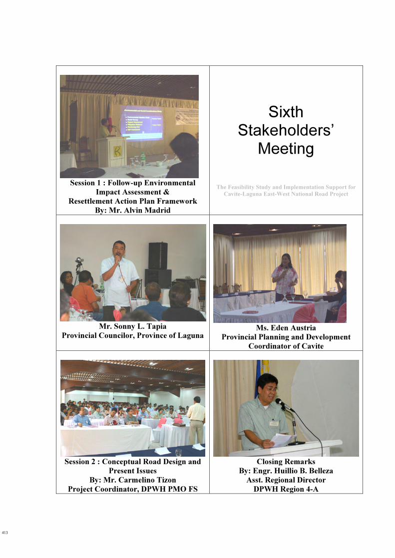
Session 1 : Follow-up Environmental
Impact Assessment &
Resettlement Action Plan Framework
By: Mr. Alvin Madrid
Sixth Stakeholders’
Meeting
The Feasibility Study and Implementation Support for
Cavite-Laguna East-West National Road Project
Mr. Sonny L. Tapia
Provincial Councilor, Province of Laguna
Ms. Eden Austria
Provincial Planning and Development
Coordinator of Cavite
Session 2 : Conceptual Road Design and
Present Issues
By: Mr. Carmelino Tizon
Project Coordinator, DPWH PMO FS
Closing Remarks
By: Engr. Huillio B. Belleza
Asst. Regional Director
DPWH Region 4-A
413
Eaoc_9.s r t
\
s+x.
lHII
s4ivNt
\)
* \
\,--+'x
\
\tA]
$I
IA
\
aNs.||'
ft
Np\
I. T>-T
tI
\
lqt-+--
=
I-+_IIt\t
i\J
x\t
\
\<{
J*
)
)
\
\s.
\[\
d\ V\..t-\
)
:hocoEo.-9o
F
t-f!/>-
f.
$ld-
F.fs\-ss
6
ocoCD
c>a
\>E\\
---)r<\*
n\.
\
q
C
vJ$
q/1
J)
a'+YM
I_s
<-
/ir.p.<.
t
flJIC4
€.L
+Gr{-
(9
-4-
v
K.
\.7
V]
c,"9oc-c',oo
N\\
:{\J
:*
d
'/g1
F-!rart
' < \
\t\ \
..-\
'{-
\)
\ x
CtV
C\l
Jc 'so
t - (
{
s, f t
.s+
(
$7 r D
.{\
J
{
5ou
N
rc
x'$
) !P {t<
- D
))
\ o
f,<-*
I
i c r
.t
€=CIDv
*fJ
J
eq
{
t>s oa_
aN.za)t
oEoz
s+94
N\
-q. \
L....-
B*f
aIIia0_
6l
*
\
a\<!o
o\'-D\s
s-.1-\\
.\J
\-Y
\q\*s
(5
dI
,6-\
V
c\
;
x
p
>-l ruo/I
\{a\l
\\J-l
-t
i-a
(\)eA
$j
Y
i'i
\
r0fiP$r$rts{Dtr@
\z
I>+<q
5t
€/
' Y
!\
rl\*
FF
E
\
ct
sF
%f-{
- U
€
3-K
\ \
E.=
1?t
€
CJ
)'tiIP
d
(\I
-\-g
€
'9D*
@
&=v
aao
g'
<
,.R
si
K>-r(
Fq
5 <
_.co.1
ro
(,o04Eood,
E eE EE oZ g
.:6 ' == Fi Bq c ltll
d s Ao o : u rS g ! oE = 9 2e H 5b t I o8 E R za I d Ic O - Fe - a , t ': F E vE 5 pO cE 9- 9 PoE sP 36 RI ' E= - tv, (\l
=o-tttooo.cF
415
l-*jF
l--bcU,r-ts-(J
cu)
l)
A
1J
p
Jt, ix6
on
{ \\
t!srb
kN\R
)\a
.o\
nq-
\5\
vN
\Juo
sN
\\
$N$NL-\
N
\){bF\A)
\
=
.-ad
\
6l
u
4".l)T4(]
d
s,b,o
)
I
IJst \w
(toEo.oooc,
E s..0 EE oz nt ; , EO E= E-!. 6at, oo o
tll
i o Eo E - 9a r b T r rf g i crF = 9 =Y q . =E E P o8 E R zl ; i . t l l. 7 r V E | -c o - F9 e . E -E . c vE 6 &O cE 9- 9 SoE s9 8E Rt t E
a t N
Fo6ooIL
o.c
416