Embed Size (px)
Citation preview
HOT SPRINGS COUNTY ANNEX
Hot Springs County Annex Region 6 Hazard Mitigation Plan 2016 DRAFT 1
1 Mitigation Planning and County Planning Team
Hot Springs County developed this annex during the development of the 2016 Region 6 Hazard
Mitigation Plan. This represents the first local hazard mitigation plan developed for the County
and its municipalities. As part of the regional planning process the County established a Hazard
Mitigation Planning Committee (HMPC) to develop the mitigation plan and identify potential
mitigation projects. The following jurisdictions participated in the DMA planning process for the
County.
Hot Springs County
Town of Thermopolis
Town of East Thermopolis
Town of Kirby
More details on the planning process followed and how the counties, municipalities and
stakeholders participated can be referenced in Chapter 3 of the base plan. Additional details on
which local government departments participated and who represented them are listed in Appendix
A.
2 Geography and Climate
Hot Springs County was created on February 21, 1911. The county has a total area of 2,006 square
miles, making it the smallest county by area in Wyoming. The Absaroka Mountain Range lies on
the west side of the county, while the Bridger Mountains surround the east side. Hot Springs
County also includes the southern portion of Bighorn Basin.
Counties adjacent to Hot Springs include Washakie, Fremont, and Park County. Towns include
Thermopolis, East Thermopolis and Kirby.
The County experiences a semi-arid climate with long, cold, dry winters and hot, dry summers.
The average high temperature is 65.53 and the average low temperature is around 33.53 with the
average annual precipitation around 12.04 inches per year.
3 Population Trends
As of the 2010 United States Census, there were a total of 4,812 people living in Hot Springs
County. With a population of 4,882 people recorded in the 2000 US Census, the county’s
population decreased by 1.45% in that timeframe. The county’s population was estimated at 4,741
in 2015, showing a decrease by 1.5%.
Hot Springs County Annex DRAFT 2 Region 6 Hazard Mitigation Plan 2016
The Town of Thermopolis is the County’s principal population center.
Table 3.1. Population Estimates for Communities 2010-2015
2010 2011 2012 2013 2014 2015
Thermopolis 3,010 3,015 3,035 3,037 3,005 2,974
East Thermopolis 254 254 255 254 251 248
Kirby 92 93 93 93 93 92
Source: American Factfinder, U.S. Census www.census.gov
Select Census demographic and social characteristics for Hot Springs County are shown in Table
3.2. The table indicates the proportion of the population that may have special needs, such as the
elderly or children under 5 years of age.
Hot Springs County Annex DRAFT 3 Region 6 Hazard Mitigation Plan 2016
Table 3.2. Hot Springs County Demographic Profile
People
Hot Springs County
Population
Population estimates, July 1, 2015, (V2015) 4,741
Population, percent change - April 1, 2010 (estimates base) to July 1, 2015, (V2015) -1.5
Population, Census, April 1, 2010 4,812
Age and Sex
Persons under 5 years, percent, July 1, 2015, (V2015) 4.5
Persons under 18 years, percent, July 1, 2015, (V2015) 20.6
Persons 65 years and over, percent, July 1, 2015, (V2015) 24.3
Female persons, percent, July 1, 2015, (V2015) 49.5
Race and Hispanic Origin
White alone, percent, July 1, 2015, (V2015) (a) 95.6
Black or African American alone, percent, July 1, 2015, (V2015) (a) 0.6
American Indian and Alaska Native alone, percent, July 1, 2015, (V2015) (a) 1.7
Asian alone, percent, July 1, 2015, (V2015) (a) 0.6
Native Hawaiian and Other Pacific Islander alone, percent, July 1, 2015, (V2015) (a) 0.1
Two or More Races, percent, July 1, 2015, (V2015) 1.5
Hispanic or Latino, percent, July 1, 2015, (V2015) (b) 4.5
White alone, not Hispanic or Latino, percent, July 1, 2015, (V2015) 91.5
Education
High school graduate or higher, percent of persons age 25 years+, 2010-2014 87.5
Bachelor's degree or higher, percent of persons age 25 years+, 2010-2014 19.5
Source: U.S. Census Bureau www.census.gov/ *Hispanic or Latino is considered to be an ethnicity and not a race. People who identify themselves as Hispanic or Latino can
belong to one or more races. Therefore, the total percentage can be greater than 100%.
4 Development Trends
During the 2016 Regional Plan development the HMPC discussed growth and development
trends in the County including:
Future development in East Thermopolis includes a large-scale renovation and modernization
project at the Hot Springs County Memorial Hospital.
The Wyoming Dinosaur Center, currently located in East Thermopolis has purchased land
south of Thermopolis for development.
Though there is no growth into timbered areas at this time, the potential exists for
range/grassland fires to threaten housing in all areas of Hot Springs County.
Hot Springs County Annex DRAFT 4 Region 6 Hazard Mitigation Plan 2016
Building in the rural areas south and west of Thermopolis continues at a steady pace. There
are a few small subdivisions, but main development is on small acreage parcels-5 acres or less.
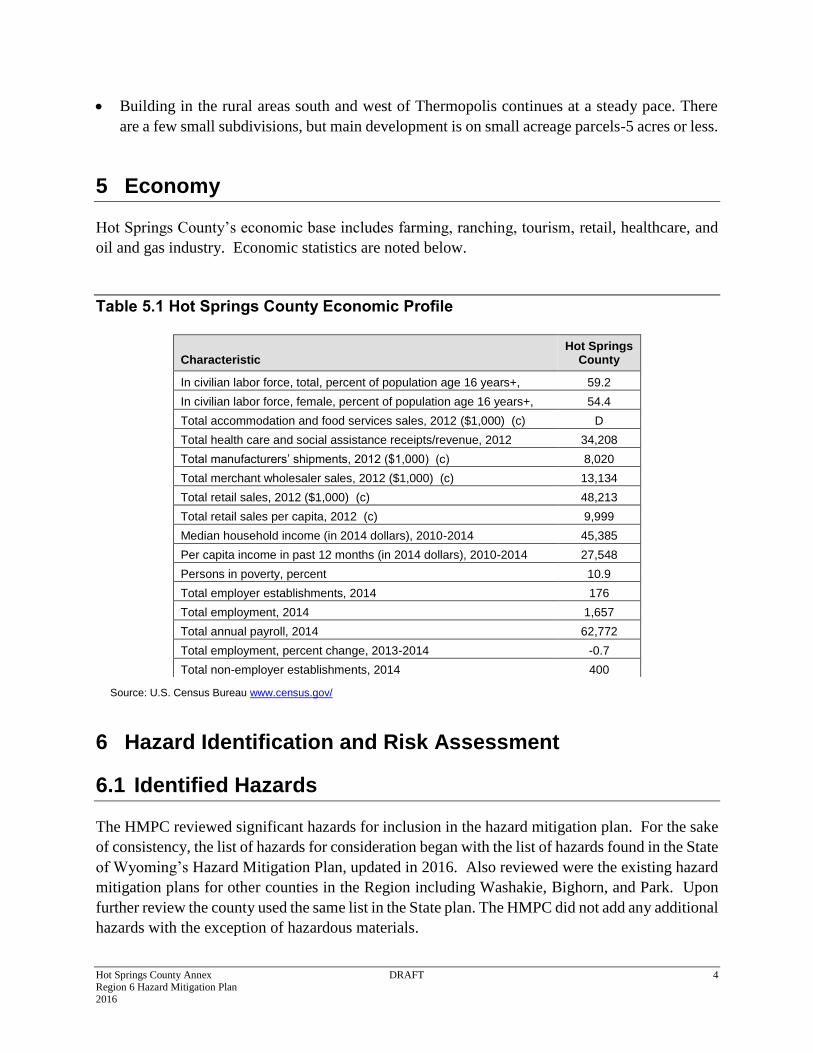
5 Economy
Hot Springs County’s economic base includes farming, ranching, tourism, retail, healthcare, and
oil and gas industry. Economic statistics are noted below.
Table 5.1 Hot Springs County Economic Profile
Source: U.S. Census Bureau www.census.gov/
6 Hazard Identification and Risk Assessment
6.1 Identified Hazards
The HMPC reviewed significant hazards for inclusion in the hazard mitigation plan. For the sake
of consistency, the list of hazards for consideration began with the list of hazards found in the State
of Wyoming’s Hazard Mitigation Plan, updated in 2016. Also reviewed were the existing hazard
mitigation plans for other counties in the Region including Washakie, Bighorn, and Park. Upon
further review the county used the same list in the State plan. The HMPC did not add any additional
hazards with the exception of hazardous materials.
Characteristic Hot Springs
County
In civilian labor force, total, percent of population age 16 years+, 2010-2014
59.2
In civilian labor force, female, percent of population age 16 years+, 2010-2014
54.4
Total accommodation and food services sales, 2012 ($1,000) (c) D
Total health care and social assistance receipts/revenue, 2012 ($1,000) (c)
34,208
Total manufacturers’ shipments, 2012 ($1,000) (c) 8,020
Total merchant wholesaler sales, 2012 ($1,000) (c) 13,134
Total retail sales, 2012 ($1,000) (c) 48,213
Total retail sales per capita, 2012 (c) 9,999
Median household income (in 2014 dollars), 2010-2014 45,385
Per capita income in past 12 months (in 2014 dollars), 2010-2014 27,548
Persons in poverty, percent 10.9
Total employer establishments, 2014 176
Total employment, 2014 1,657
Total annual payroll, 2014 62,772
Total employment, percent change, 2013-2014 -0.7
Total non-employer establishments, 2014 400
Hot Springs County Annex DRAFT 5 Region 6 Hazard Mitigation Plan 2016
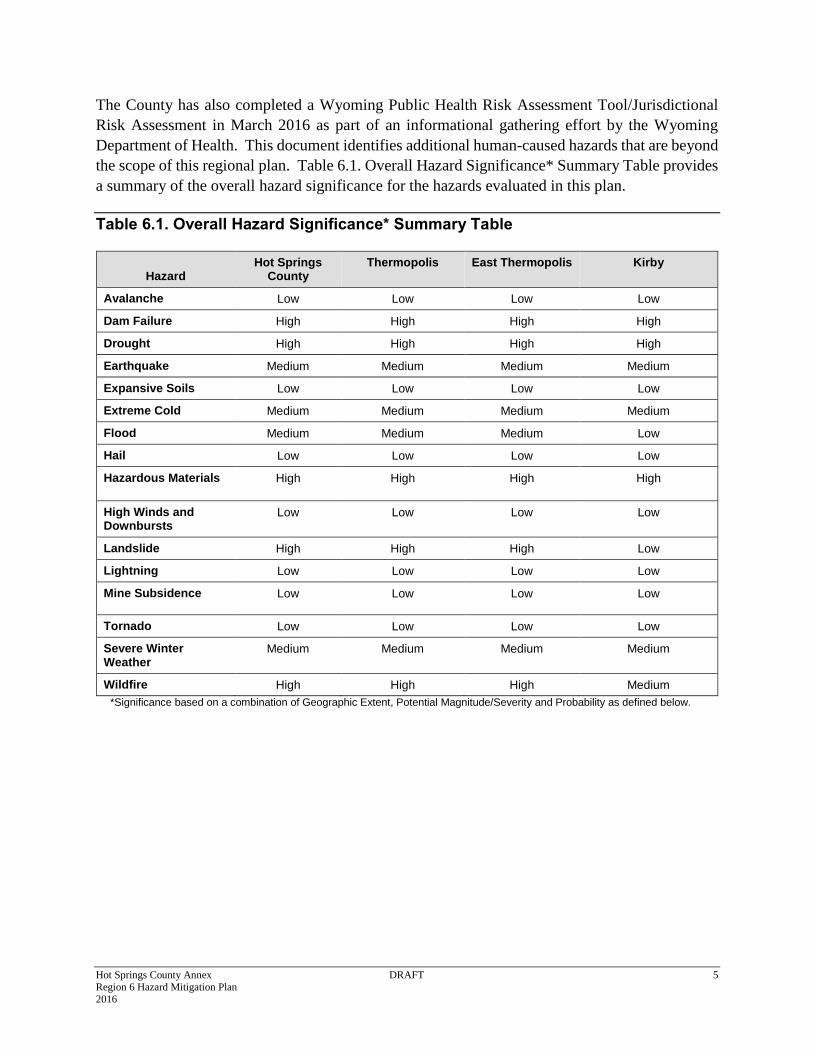
The County has also completed a Wyoming Public Health Risk Assessment Tool/Jurisdictional
Risk Assessment in March 2016 as part of an informational gathering effort by the Wyoming
Department of Health. This document identifies additional human-caused hazards that are beyond
the scope of this regional plan. Table 6.1. Overall Hazard Significance* Summary Table provides
a summary of the overall hazard significance for the hazards evaluated in this plan.
Table 6.1. Overall Hazard Significance* Summary Table
Hazard Hot Springs
County Thermopolis East Thermopolis Kirby
Avalanche Low Low Low Low
Dam Failure High High High High
Drought High High High High
Earthquake Medium Medium Medium Medium
Expansive Soils Low Low Low Low
Extreme Cold Medium Medium Medium Medium
Flood Medium Medium Medium Low
Hail Low Low Low Low
Hazardous Materials High High High High
High Winds and Downbursts
Low Low Low Low
Landslide High High High Low
Lightning Low Low Low Low
Mine Subsidence Low Low Low Low
Tornado Low Low Low Low
Severe Winter Weather
Medium Medium Medium Medium
Wildfire High High High Medium
*Significance based on a combination of Geographic Extent, Potential Magnitude/Severity and Probability as defined below.
Hot Springs County Annex DRAFT 6 Region 6 Hazard Mitigation Plan 2016
Catastrophic: More than 50 percent of property is severely
damaged, facilities and services are unavailable or hindered
for more than 2 weeks, the medical response system is
overwhelmed for an extended period of time or many deaths
occur.
High: The criteria consistently fall along the high ranges of the
classification and the event exerts significant and frequent impacts on
the planning area. This rating is also sometimes utilized for hazards
with a high psychological impact or for hazards that the jurisdiction
identifies as particularly relevant.
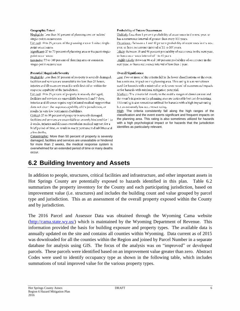
6.2 Building Inventory and Assets
In addition to people, structures, critical facilities and infrastructure, and other important assets in
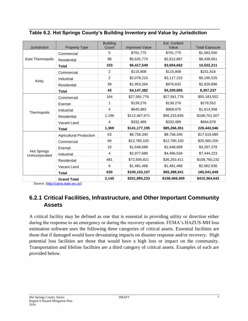
Hot Springs County are potentially exposed to hazards identified in this plan. Table 6.2
summarizes the property inventory for the County and each participating jurisdiction, based on
improvement value (i.e. structures) and includes the building count and value grouped by parcel
type and jurisdiction. This as an assessment of the overall property exposed within the County
and by jurisdiction.
The 2016 Parcel and Assessor Data was obtained through the Wyoming Cama website
(http://cama.state.wy.us/) which is maintained by the Wyoming Department of Revenue. This
information provided the basis for building exposure and property types. The available data is
annually updated on the site and contains all counties within Wyoming. Data current as of 2015
was downloaded for all the counties within the Region and joined by Parcel Number in a separate
database for analysis using GIS. The focus of the analysis was on “improved” or developed
parcels. These parcels were identified based on an improvement value greater than zero. Abstract
Codes were used to identify occupancy type as shown in the following table, which includes
summations of total improved value for the various property types.
Hot Springs County Annex DRAFT 7 Region 6 Hazard Mitigation Plan 2016
Table 6.2. Hot Springs County’s Building Inventory and Value by Jurisdiction
Jurisdiction Property Type Building Count Improved Value
Est. Content Value Total Exposure
East Thermopolis
Commercial 5 $791,775 $791,775 $1,583,550
Residential 98 $5,625,774 $2,812,887 $8,438,661
Total 103 $6,417,549 $3,604,662 10,022,211
Kirby
Commercial 2 $115,908 $115,908 $231,816
Industrial 2 $2,078,210 $3,117,315 $5,195,525
Residential 39 $1,953,264 $976,632 $2,929,896
Total 43 $4,147,382 $4,209,855 8,357,237
Thermopolis
Commercial 164 $27,591,776 $27,591,776 $55,183,552
Exempt 1 $139,276 $139,276 $278,552
Industrial 4 $645,983 $968,975 $1,614,958
Residential 1,196 $112,467,671 $56,233,836 $168,701,507
Vacant Land 4 $332,489 $332,489 $664,978
Total 1,369 $141,177,195 $85,266,351 226,443,546
Hot Springs Unincorporated
Agricultural Production 63 $8,758,340 $8,758,340 $17,516,680
Commercial 66 $12,780,100 $12,780,100 $25,560,200
Exempt 10 $1,648,689 $1,648,689 $3,297,378
Industrial 4 $2,977,689 $4,466,534 $7,444,223
Residential 481 $72,506,821 $36,253,411 $108,760,232
Vacant Land 6 $1,481,468 $1,481,468 $2,962,936
Total 630 $100,153,107 $65,388,541 165,541,648
Grand Total 2,145 $251,895,233 $158,469,409 $410,364,642
Source: (http://cama.state.wy.us/)
6.2.1 Critical Facilities, Infrastructure, and Other Important Community
Assets
A critical facility may be defined as one that is essential in providing utility or direction either
during the response to an emergency or during the recovery operation. FEMA’s HAZUS-MH loss
estimation software uses the following three categories of critical assets. Essential facilities are
those that if damaged would have devastating impacts on disaster response and/or recovery. High
potential loss facilities are those that would have a high loss or impact on the community.
Transportation and lifeline facilities are a third category of critical assets. Examples of each are
provided below.
Hot Springs County Annex DRAFT 8 Region 6 Hazard Mitigation Plan 2016
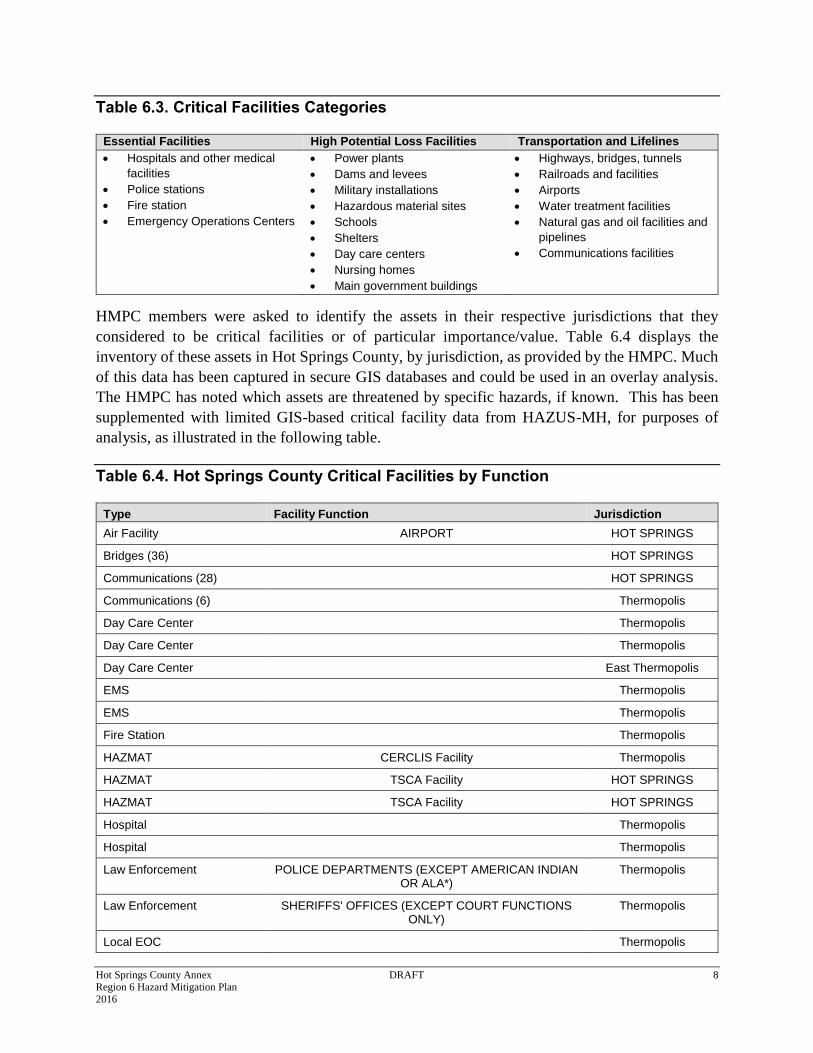
Table 6.3. Critical Facilities Categories
Essential Facilities High Potential Loss Facilities Transportation and Lifelines
Hospitals and other medical
facilities
Police stations
Fire station
Emergency Operations Centers
Power plants
Dams and levees
Military installations
Hazardous material sites
Schools
Shelters
Day care centers
Nursing homes
Main government buildings
Highways, bridges, tunnels
Railroads and facilities
Airports
Water treatment facilities
Natural gas and oil facilities and
pipelines
Communications facilities
HMPC members were asked to identify the assets in their respective jurisdictions that they
considered to be critical facilities or of particular importance/value. Table 6.4 displays the
inventory of these assets in Hot Springs County, by jurisdiction, as provided by the HMPC. Much
of this data has been captured in secure GIS databases and could be used in an overlay analysis.
The HMPC has noted which assets are threatened by specific hazards, if known. This has been
supplemented with limited GIS-based critical facility data from HAZUS-MH, for purposes of
analysis, as illustrated in the following table.
Table 6.4. Hot Springs County Critical Facilities by Function
Type Facility Function Jurisdiction
Air Facility AIRPORT HOT SPRINGS
Bridges (36) HOT SPRINGS
Communications (28) HOT SPRINGS
Communications (6) Thermopolis
Day Care Center Thermopolis
Day Care Center Thermopolis
Day Care Center East Thermopolis
EMS Thermopolis
EMS Thermopolis
Fire Station Thermopolis
HAZMAT CERCLIS Facility Thermopolis
HAZMAT TSCA Facility HOT SPRINGS
HAZMAT TSCA Facility HOT SPRINGS
Hospital Thermopolis
Hospital Thermopolis
Law Enforcement POLICE DEPARTMENTS (EXCEPT AMERICAN INDIAN OR ALA*)
Thermopolis
Law Enforcement SHERIFFS' OFFICES (EXCEPT COURT FUNCTIONS ONLY)
Thermopolis
Local EOC Thermopolis
Hot Springs County Annex DRAFT 9 Region 6 Hazard Mitigation Plan 2016
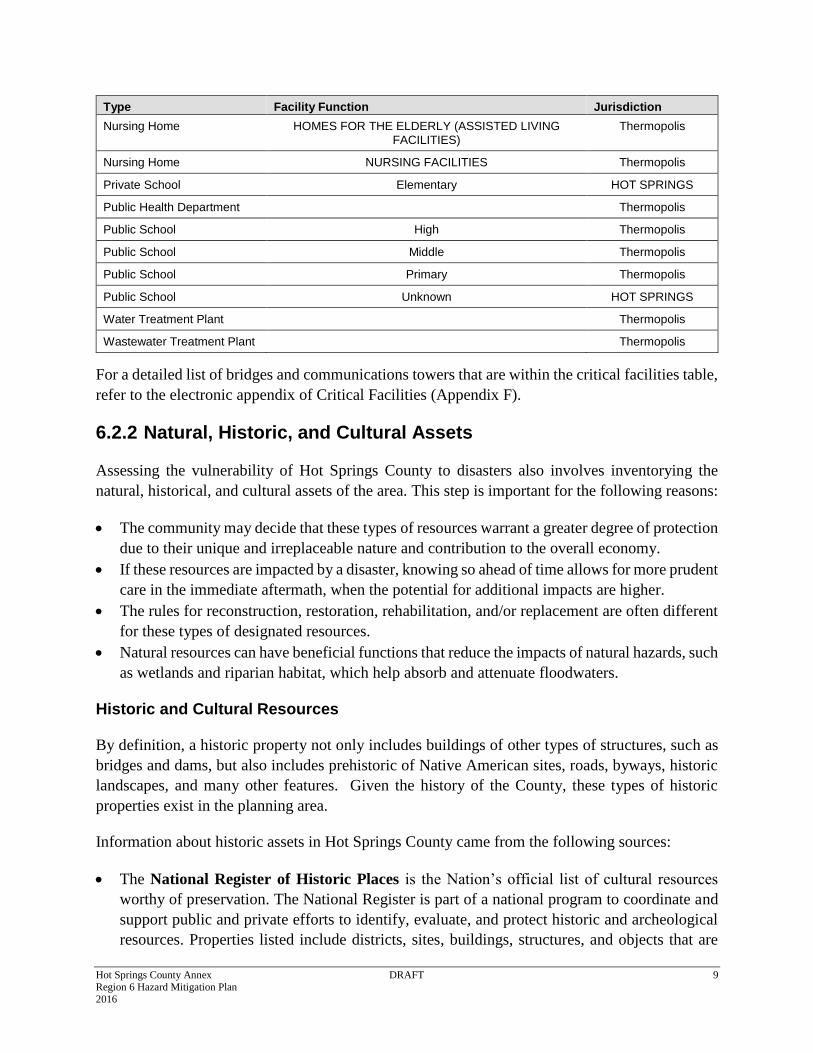
Type Facility Function Jurisdiction
Nursing Home HOMES FOR THE ELDERLY (ASSISTED LIVING FACILITIES)
Thermopolis
Nursing Home NURSING FACILITIES Thermopolis
Private School Elementary HOT SPRINGS
Public Health Department Thermopolis
Public School High Thermopolis
Public School Middle Thermopolis
Public School Primary Thermopolis
Public School Unknown HOT SPRINGS
Water Treatment Plant Thermopolis
Wastewater Treatment Plant Thermopolis
For a detailed list of bridges and communications towers that are within the critical facilities table,
refer to the electronic appendix of Critical Facilities (Appendix F).
6.2.2 Natural, Historic, and Cultural Assets
Assessing the vulnerability of Hot Springs County to disasters also involves inventorying the
natural, historical, and cultural assets of the area. This step is important for the following reasons:
The community may decide that these types of resources warrant a greater degree of protection
due to their unique and irreplaceable nature and contribution to the overall economy.
If these resources are impacted by a disaster, knowing so ahead of time allows for more prudent
care in the immediate aftermath, when the potential for additional impacts are higher.
The rules for reconstruction, restoration, rehabilitation, and/or replacement are often different
for these types of designated resources.
Natural resources can have beneficial functions that reduce the impacts of natural hazards, such
as wetlands and riparian habitat, which help absorb and attenuate floodwaters.
Historic and Cultural Resources
By definition, a historic property not only includes buildings of other types of structures, such as
bridges and dams, but also includes prehistoric of Native American sites, roads, byways, historic
landscapes, and many other features. Given the history of the County, these types of historic
properties exist in the planning area.
Information about historic assets in Hot Springs County came from the following sources:
The National Register of Historic Places is the Nation’s official list of cultural resources
worthy of preservation. The National Register is part of a national program to coordinate and
support public and private efforts to identify, evaluate, and protect historic and archeological
resources. Properties listed include districts, sites, buildings, structures, and objects that are
Hot Springs County Annex DRAFT 10 Region 6 Hazard Mitigation Plan 2016
significant in American history, architecture, archeology, engineering, and culture. The
National Register is administered by the National Park Service, which is part of the U.S.
Department of the Interior.
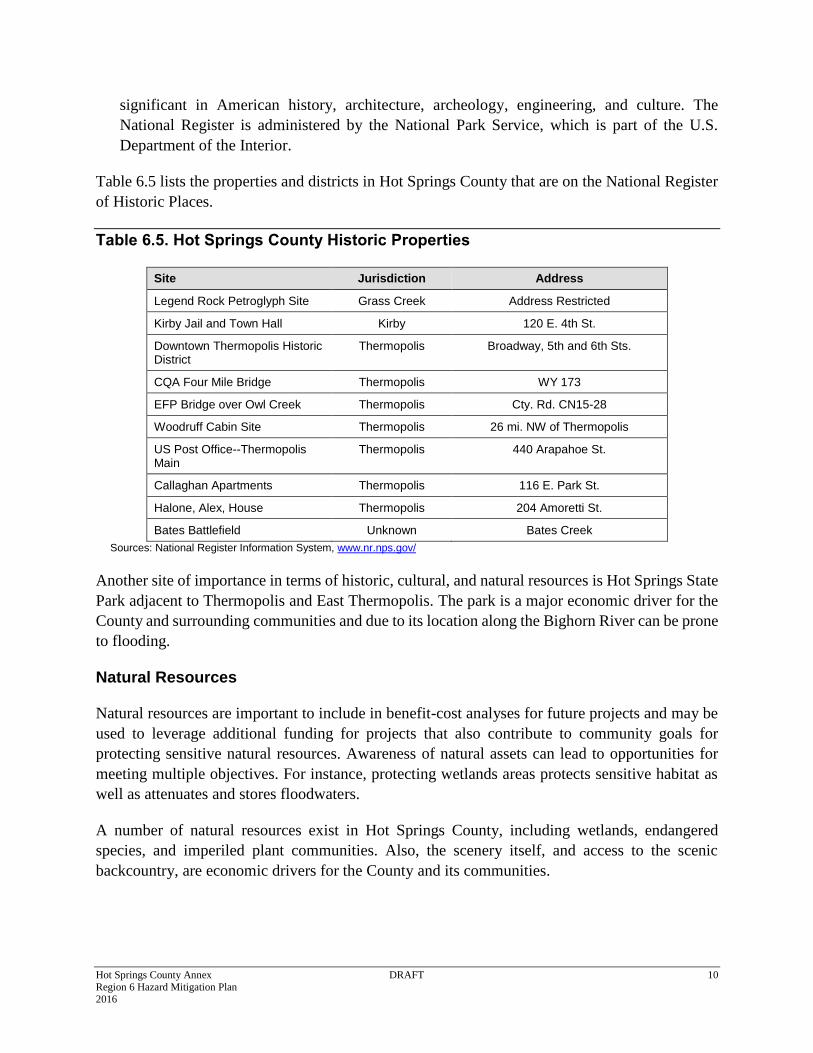
Table 6.5 lists the properties and districts in Hot Springs County that are on the National Register
of Historic Places.
Table 6.5. Hot Springs County Historic Properties
Site Jurisdiction Address
Legend Rock Petroglyph Site Grass Creek Address Restricted
Kirby Jail and Town Hall Kirby 120 E. 4th St.
Downtown Thermopolis Historic District
Thermopolis Broadway, 5th and 6th Sts.
CQA Four Mile Bridge Thermopolis WY 173
EFP Bridge over Owl Creek Thermopolis Cty. Rd. CN15-28
Woodruff Cabin Site Thermopolis 26 mi. NW of Thermopolis
US Post Office--Thermopolis Main
Thermopolis 440 Arapahoe St.
Callaghan Apartments Thermopolis 116 E. Park St.
Halone, Alex, House Thermopolis 204 Amoretti St.
Bates Battlefield Unknown Bates Creek
Sources: National Register Information System, www.nr.nps.gov/
Another site of importance in terms of historic, cultural, and natural resources is Hot Springs State
Park adjacent to Thermopolis and East Thermopolis. The park is a major economic driver for the
County and surrounding communities and due to its location along the Bighorn River can be prone
to flooding.
Natural Resources
Natural resources are important to include in benefit-cost analyses for future projects and may be
used to leverage additional funding for projects that also contribute to community goals for
protecting sensitive natural resources. Awareness of natural assets can lead to opportunities for
meeting multiple objectives. For instance, protecting wetlands areas protects sensitive habitat as
well as attenuates and stores floodwaters.
A number of natural resources exist in Hot Springs County, including wetlands, endangered
species, and imperiled plant communities. Also, the scenery itself, and access to the scenic
backcountry, are economic drivers for the County and its communities.
Hot Springs County Annex DRAFT 11 Region 6 Hazard Mitigation Plan 2016
Wetlands
Wetlands are a valuable natural resource for communities, due to their benefits to water quality,
wildlife protection, recreation, and education, and play an important role in hazard mitigation.
Wetlands reduce flood peaks and slowly release floodwaters to downstream areas. When surface
runoff is dampened, the erosive powers of the water are greatly diminished. Furthermore, the
reduction in the velocity of inflowing water as it passes through a wetland helps remove sediment
being transported by the water. They also provide drought relief in water-scarce areas where the
relationship between water storage and streamflow regulation are vital.
Endangered Species
To further understand natural resources that may be particularly vulnerable to a hazard event, as
well as those that need consideration when implementing mitigation activities, it is important to
identify at-risk species (i.e., endangered species) in the planning area. An endangered species is
any species of fish, plant life, or wildlife that is in danger of extinction throughout all or most of
its range. A threatened species is a species that is likely to become an endangered species within
the foreseeable future throughout all or a significant portion of its range. Both endangered and
threatened species are protected by law and any future hazard mitigation projects are subject to
these laws. Candidate species are plants and animals that have been proposed as endangered or
threatened but are not currently listed.
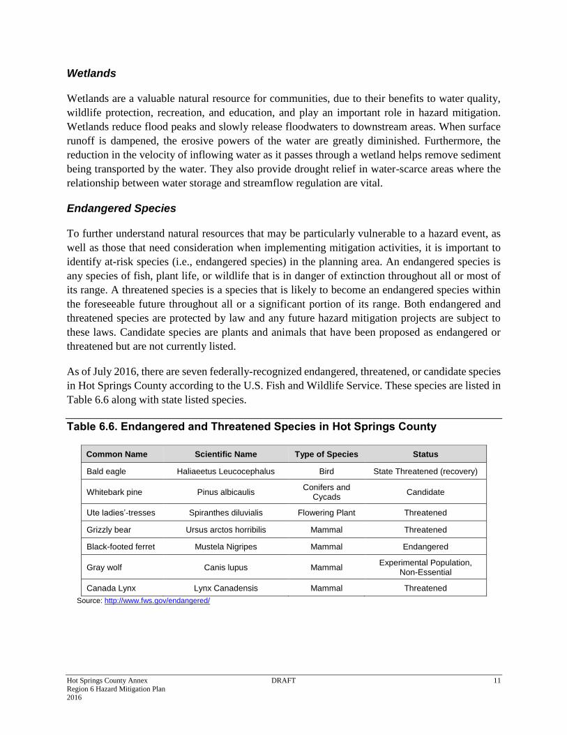
As of July 2016, there are seven federally-recognized endangered, threatened, or candidate species
in Hot Springs County according to the U.S. Fish and Wildlife Service. These species are listed in
Table 6.6 along with state listed species.
Table 6.6. Endangered and Threatened Species in Hot Springs County
Common Name Scientific Name Type of Species Status
Bald eagle Haliaeetus Leucocephalus Bird State Threatened (recovery)
Whitebark pine Pinus albicaulis Conifers and
Cycads Candidate
Ute ladies’-tresses Spiranthes diluvialis Flowering Plant Threatened
Grizzly bear Ursus arctos horribilis Mammal Threatened
Black-footed ferret Mustela Nigripes Mammal Endangered
Gray wolf Canis lupus Mammal Experimental Population,
Non-Essential
Canada Lynx Lynx Canadensis Mammal Threatened
Source: http://www.fws.gov/endangered/
Hot Springs County Annex DRAFT 12 Region 6 Hazard Mitigation Plan 2016
6.3 Vulnerability to Specific Hazards
This section details vulnerability to specific hazards, where quantifiable, only where it differs from
that of the Region. The results of detailed GIS analyses used to estimate potential for future losses
are presented here, in addition to maps of hazard areas and details by jurisdiction and building
type. For a discussion of the methodology used to develop the loss estimates refer to Chapter 4 of
the base plan. In many cases Chapter 4 contains information that differentiates the risk by county
thus the information is not duplicated here. For most of the weather-related hazards the risk does
not vary significantly enough from the rest of the Region and thus the reader should refer to
Chapter 4. Only unique issues or vulnerabilities are discussed, where applicable.
Avalanche
Dam Failure
Drought
Earthquake
Extreme Cold
Expansive Soils
Flood
Hail
Hazards Materials
High Winds and Downbursts
Landslide, Debris Flow and Rockfall
Lightning
Mine Subsidence
Tornado
Wildfire
Winter Weather
6.3.1 Avalanche
Avalanche prone areas are limited to the far west part of the County but have had negligible impact.
Refer to Chapter 4 in the base plan for a discussion of general avalanche risk in the Region.
6.3.2 Dam Failure
Due to the presences of Boysen dam upstream of the County and major population centers
including Thermopolis and East Thermopolis there is considerable risk to dam failure. There are
also many dams upstream above Boysen in Fremont County. A table and map in Chapter 4
indicates the High and Significant Hazard dams upstream of the County.
Boysen Dam and Reservoir is an earthen dam located on the Wind River, approximately 20 miles
south of Thermopolis in Fremont County. The current dam is operated by the U.S. Federal Bureau
Hot Springs County Annex DRAFT 13 Region 6 Hazard Mitigation Plan 2016
of Reclamation, and is an earth-filled dam with a structural height of 220 feet. Total flood damages
reduced by the reservoir since construction totaled about $75.0 million by the end of 1998. This
dam was last inspected on June 22, 2010. If Boysen Dam fails, impacts could be significant to
Thermopolis, East Thermopolis, the unincorporated areas along the Bighorn River, and Kirby,
including loss of life.
The Anchor Dam is the only High Hazard dam in the County. It has a dike built to keep water
from going into sinkholes nearby. Failure of the dam would impact Owl Creek and homes along
stream. It has some flood control but is mostly intended for irrigation purposes. It has an
Emergency Action Plan and warning system.
6.3.3 Drought
Similar to the rest of the Region drought is a high significance hazard for the County. Members of
the HMPC noted the following regarding water supply and impacts from drought in Hot Springs
County:
Water supply in Hot Springs County comes from rivers, wells, and groundwater recovery;
Senior Water Right calls on the Bighorn River during times of drought can result in lower
flows. The Hot Springs flows can be impacted by low river flows. The State has the option to
buy water from Boysen Reservoir during drought;
Grazing cattle are impacted the most during intense drought;
Owl Creek has a cyclical flow depending on drought; and
1996-1998 fire season occurred during a drought. So emergency services could not use County
water for firefighting.
Refer to the Chapter 4 in the Base Plan for additional discussion of drought risk related to the
Region and the County.
6.3.4 Extreme Cold
Vulnerability to extreme cold is not noticeably different from the rest of the region and is
considered a medium significance hazard. Refer to Chapter 4 for a discussion of this hazard’s risk
related to Hot Springs County and the Region. Members of the HMPC noted that extreme cold
contributed to an ice jam on the Bighorn River in January of 2016 and sometimes results in burst
pipes, power outages, and impacts to trees.
6.3.5 Earthquake
As discussed in Chapter 4 earthquakes are low probability but could have considerable impacts in
Hot Springs County. During the 2016 Regional Plan development the HMPC noted the following
potential consequences of earthquake in Hot Springs County:
Earthquakes pose a risk to Boysen dam and railroad tunnels;
Hot Springs County Annex DRAFT 14 Region 6 Hazard Mitigation Plan 2016
The age of buildings is an issue as older and historic buildings in the County and Thermopolis
are more vulnerable to earthquake shaking; and
A concern was raised that if earthquakes affected the flow of the Hot Springs, which is a natural
and cultural resource, it would affect the local economy.
6.3.6 Expansive Soils
Expansive soils causes occasional problems in the County. During the 2016 Regional Plan
development the HMPC noted the following consequences of expansive soils in Hot Springs
County:
Some houses were made inhabitable south of Thermopolis by this hazard;
Issues on Highways; and
Added costs to building middle school to mitigate impacts.
Data did not exist to provide a more quantitative loss estimate. See Chapter 4 for more description
on the expansive soils hazard.
6.3.7 Flood
During the 2016 Regional Plan development the HMPC noted the following consequences of flood
hazards in Hot Springs County:
High releases from Boysen Reservoir can result in flooding along the Bighorn River;
The 300 year event in 1923 was pre-Boysen Reservoir. The Reservoir provides some flood
mitigation;
Some ice jams have occurred that have backed floodwaters into Thermopolis (1980s and
January 2015);
Prone to flash flooding: Owl Creek, Kirby Creek, Buffalo Creek, Sand Draw, Buffalo,
Gooseberry and Grass Creeks and other small creeks, washes and drainages (small watershed
between dam and Thermopolis), Red Canyon (flooded into town based on anecdote);
Hot Springs State Park is a main economic draw and also has areas prone to flooding; and
There is no flood hazard mapping in the unincorporated area
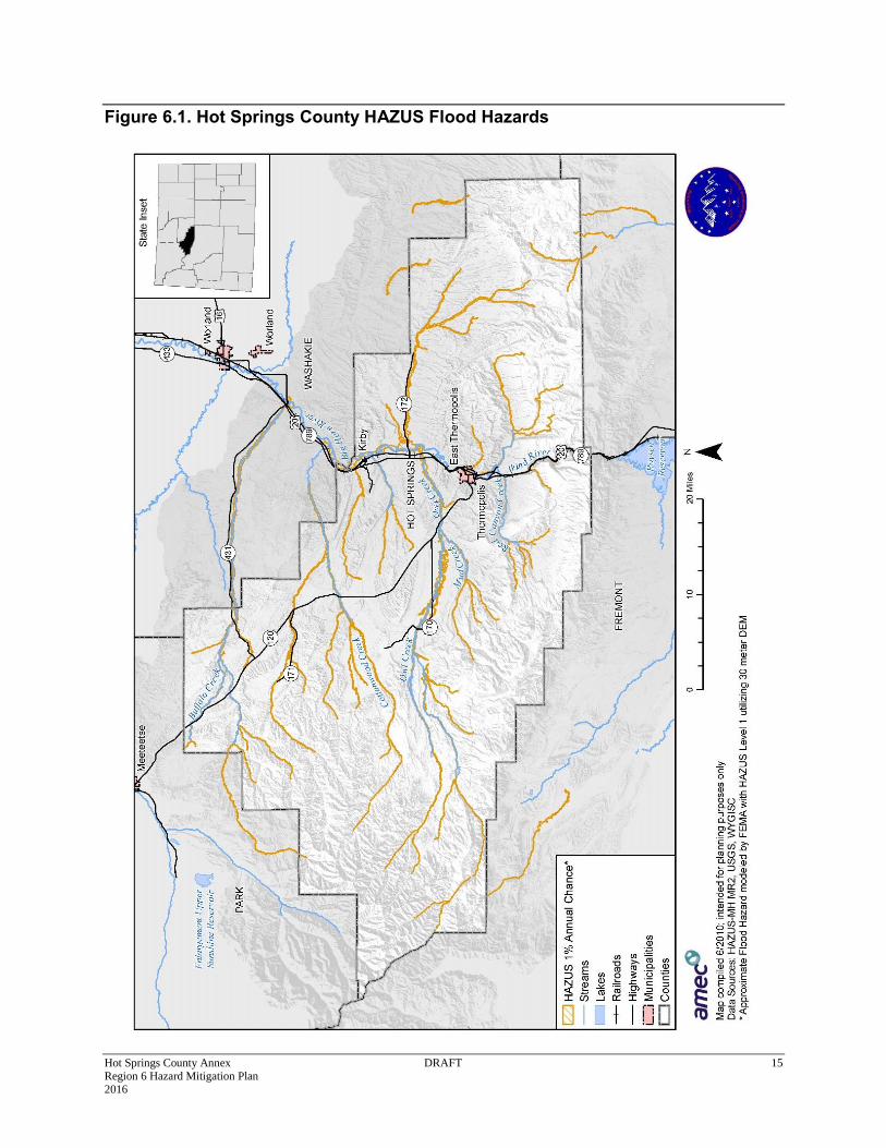
The following maps show approximate flood hazards in specific areas of Hot Springs County,
largely based on HAZUS-generated approximate flood hazard areas. FIRM mapping and analysis
only exists for Thermopolis. The FIRM was digitized during the 2016 planning effort to
accommodate a more accurate flood risk analysis with GIS.
Hot Springs County Annex DRAFT 15 Region 6 Hazard Mitigation Plan 2016
Figure 6.1. Hot Springs County HAZUS Flood Hazards
Hot Springs County Annex DRAFT 16 Region 6 Hazard Mitigation Plan 2016
Figure 6.2. Town of Thermopolis and East Thermopolis Flood Hazards
Hot Springs County Annex DRAFT 17 Region 6 Hazard Mitigation Plan 2016
Figure 6.3. Town of Kirby HAZUS Flood Hazards
Hot Springs County Annex DRAFT 18 Region 6 Hazard Mitigation Plan 2016
Potential Loss in 100-year and 500-year Floodplains
The following data results from analysis of available HAZUS and DFIRM data, and shows
potential impacts from flooding, including the number or people vulnerable, total building
exposure, and associated costs related to a 100 year or 1% annual chance flood and where data
permits the 500 year or 0.2% annual chance flood. Two analyses are provided. The first is based
on a GIS analysis based on improved parcels using a digitized FIRM for Thermopolis and an
approximate HAZUS-generated floodplain for the remainder of the County. The results of a 2010
HAZUS flood analysis, based on HAZUS inventory data, are also included to show additional
economic losses.
Table 6.7. Summary of Floodplain Population Information
Total # of Buildings Population Estimate
100 yr. flood 120 191
500 yr. flood 114 216
Total flood** 234 407
Hot Springs County Annex DRAFT 19 Region 6 Hazard Mitigation Plan 2016
Parcel Level Analyses
The following results show potential impacts from flooding, including the number or people vulnerable, total building exposure, and
associated costs related to a general flooding incident based on a parcel level analysis.
Table 6.8. Exposure and Potential Loss in 100-year Floodplain by Jurisdiction and Property Type
Jurisdiction Property Type Building Count Improved Value Est. Content Value Total Exposure Potential Loss Population
East Thermopolis
Commercial 2 $155,812 $155,812 $311,624 $77,906
Residential 16 $1,517,987 $758,994 $2,276,981 $569,245 34
Total 18 $1,673,799 $914,806 $2,588,605 $647,151
Thermopolis
Commercial 1 $125,795 $125,795 $251,590 $62,898
Industrial 2 $364,816 $547,224 $912,040 $228,010
Residential 14 $1,206,158 $603,079 $1,809,237 $452,309 30
Total 17 $1,696,769 $1,276,098 $2,972,867 $743,217
Hot Springs Unincorporated
Agricultural Production 17 $3,555,520 $3,555,520 $7,111,040 $1,777,760
Commercial 8 $1,009,529 $1,009,529 $2,019,058 $504,765
Residential 60 $7,988,350 $3,994,175 $11,982,525 $2,995,631 127
Total 85 $12,553,399 $8,559,224 $21,112,623 $5,278,156
Grand Total 120 $15,923,967 $10,750,128 $26,674,095 $6,668,524 191
Hot Springs County Annex DRAFT 20 Region 6 Hazard Mitigation Plan 2016
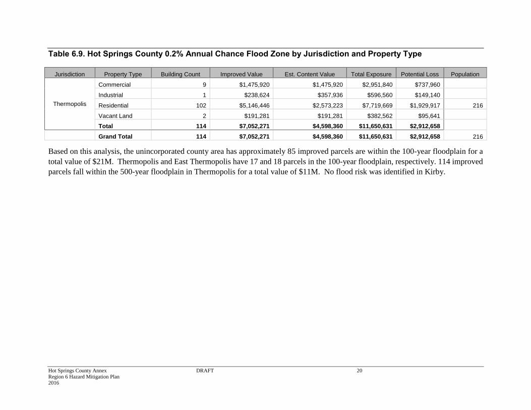
Table 6.9. Hot Springs County 0.2% Annual Chance Flood Zone by Jurisdiction and Property Type
Jurisdiction Property Type Building Count Improved Value Est. Content Value Total Exposure Potential Loss Population
Thermopolis
Commercial 9 $1,475,920 $1,475,920 $2,951,840 $737,960
Industrial 1 $238,624 $357,936 $596,560 $149,140
Residential 102 $5,146,446 $2,573,223 $7,719,669 $1,929,917 216
Vacant Land 2 $191,281 $191,281 $382,562 $95,641
Total 114 $7,052,271 $4,598,360 $11,650,631 $2,912,658
Grand Total 114 $7,052,271 $4,598,360 $11,650,631 $2,912,658 216
Based on this analysis, the unincorporated county area has approximately 85 improved parcels are within the 100-year floodplain for a
total value of $21M. Thermopolis and East Thermopolis have 17 and 18 parcels in the 100-year floodplain, respectively. 114 improved
parcels fall within the 500-year floodplain in Thermopolis for a total value of $11M. No flood risk was identified in Kirby.
Hot Springs County Annex DRAFT 21 Region 6 Hazard Mitigation Plan 2016
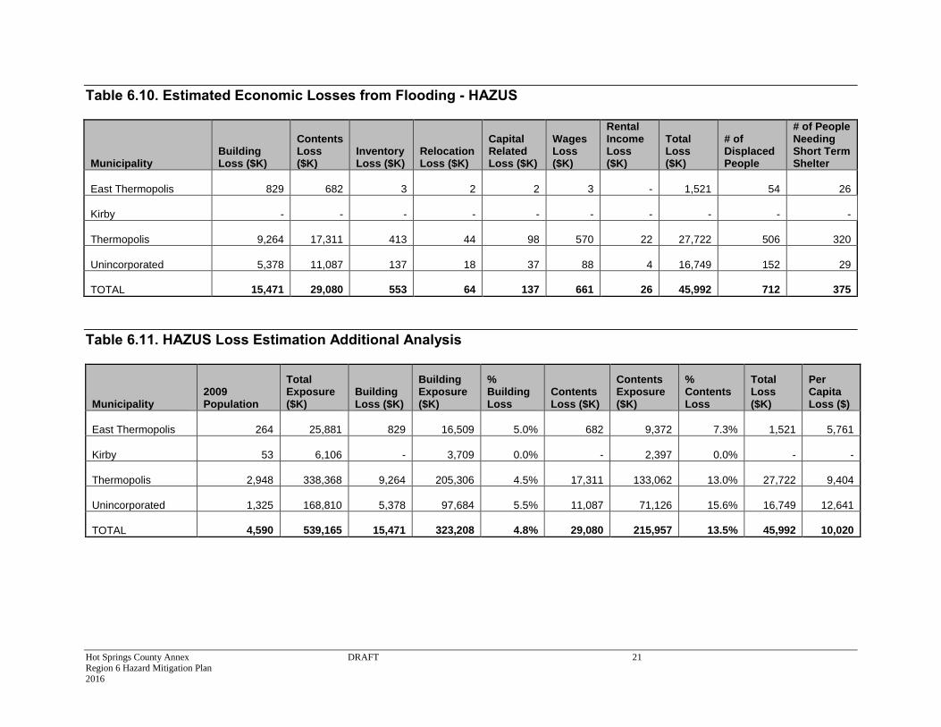
Table 6.10. Estimated Economic Losses from Flooding - HAZUS
Municipality Building Loss ($K)
Contents Loss ($K)
Inventory Loss ($K)
Relocation Loss ($K)
Capital Related Loss ($K)
Wages Loss ($K)
Rental Income Loss ($K)
Total Loss ($K)
# of Displaced People
# of People Needing Short Term Shelter
East Thermopolis 829
682
3
2
2
3
-
1,521 54
26
Kirby -
-
-
-
-
-
-
- -
-
Thermopolis 9,264
17,311
413
44
98
570
22
27,722 506
320
Unincorporated 5,378
11,087
137
18
37
88
4
16,749 152
29
TOTAL 15,471
29,080 553 64 137
661
26
45,992 712
375
Table 6.11. HAZUS Loss Estimation Additional Analysis
Municipality 2009 Population
Total Exposure ($K)
Building Loss ($K)
Building Exposure ($K)
% Building Loss
Contents Loss ($K)
Contents Exposure ($K)
% Contents Loss
Total Loss ($K)
Per Capita Loss ($)
East Thermopolis 264
25,881
829
16,509 5.0%
682
9,372 7.3%
1,521
5,761
Kirby 53
6,106
-
3,709 0.0% -
2,397 0.0%
-
-
Thermopolis 2,948
338,368
9,264
205,306 4.5% 17,311
133,062 13.0%
27,722
9,404
Unincorporated 1,325
168,810
5,378
97,684 5.5% 11,087
71,126 15.6%
16,749
12,641
TOTAL 4,590 539,165 15,471 323,208 4.8% 29,080 215,957 13.5% 45,992
10,020
Hot Springs County Annex DRAFT 22 Region 6 Hazard Mitigation Plan 2016
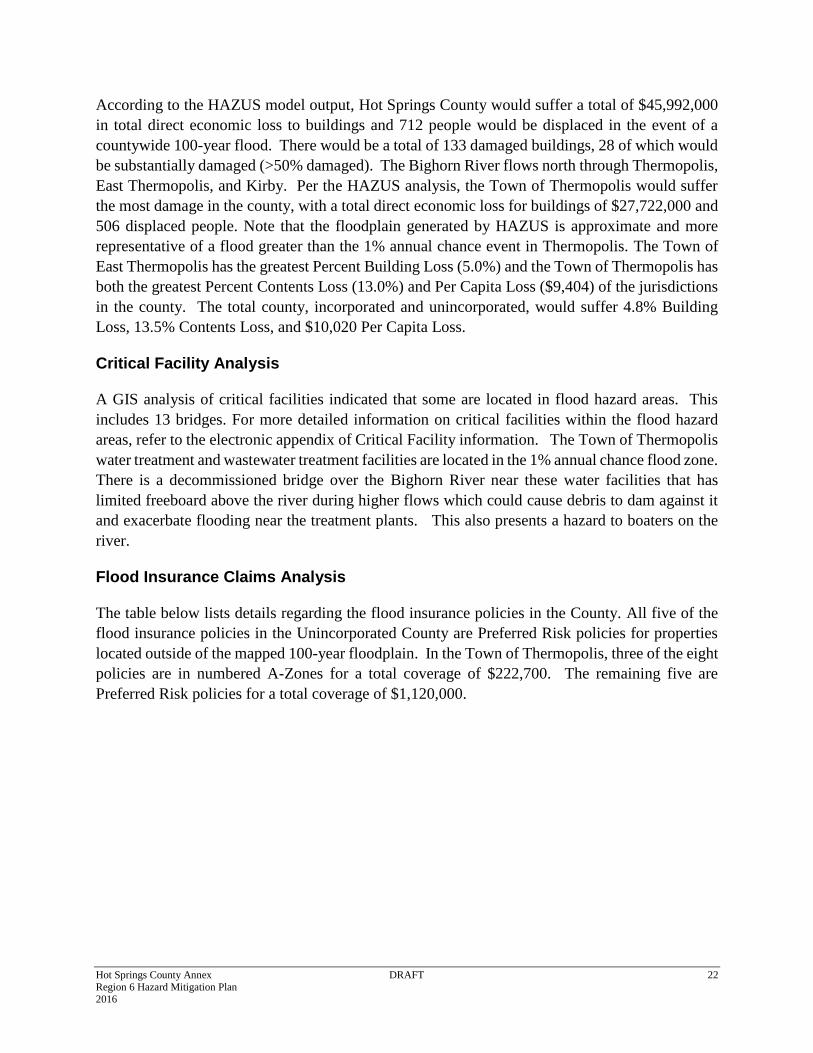
According to the HAZUS model output, Hot Springs County would suffer a total of $45,992,000
in total direct economic loss to buildings and 712 people would be displaced in the event of a
countywide 100-year flood. There would be a total of 133 damaged buildings, 28 of which would
be substantially damaged (>50% damaged). The Bighorn River flows north through Thermopolis,
East Thermopolis, and Kirby. Per the HAZUS analysis, the Town of Thermopolis would suffer
the most damage in the county, with a total direct economic loss for buildings of $27,722,000 and
506 displaced people. Note that the floodplain generated by HAZUS is approximate and more
representative of a flood greater than the 1% annual chance event in Thermopolis. The Town of
East Thermopolis has the greatest Percent Building Loss (5.0%) and the Town of Thermopolis has
both the greatest Percent Contents Loss (13.0%) and Per Capita Loss ($9,404) of the jurisdictions
in the county. The total county, incorporated and unincorporated, would suffer 4.8% Building
Loss, 13.5% Contents Loss, and $10,020 Per Capita Loss.
Critical Facility Analysis
A GIS analysis of critical facilities indicated that some are located in flood hazard areas. This
includes 13 bridges. For more detailed information on critical facilities within the flood hazard
areas, refer to the electronic appendix of Critical Facility information. The Town of Thermopolis
water treatment and wastewater treatment facilities are located in the 1% annual chance flood zone.
There is a decommissioned bridge over the Bighorn River near these water facilities that has
limited freeboard above the river during higher flows which could cause debris to dam against it
and exacerbate flooding near the treatment plants. This also presents a hazard to boaters on the
river.
Flood Insurance Claims Analysis
The table below lists details regarding the flood insurance policies in the County. All five of the
flood insurance policies in the Unincorporated County are Preferred Risk policies for properties
located outside of the mapped 100-year floodplain. In the Town of Thermopolis, three of the eight
policies are in numbered A-Zones for a total coverage of $222,700. The remaining five are
Preferred Risk policies for a total coverage of $1,120,000.
Hot Springs County Annex DRAFT 23 Region 6 Hazard Mitigation Plan 2016
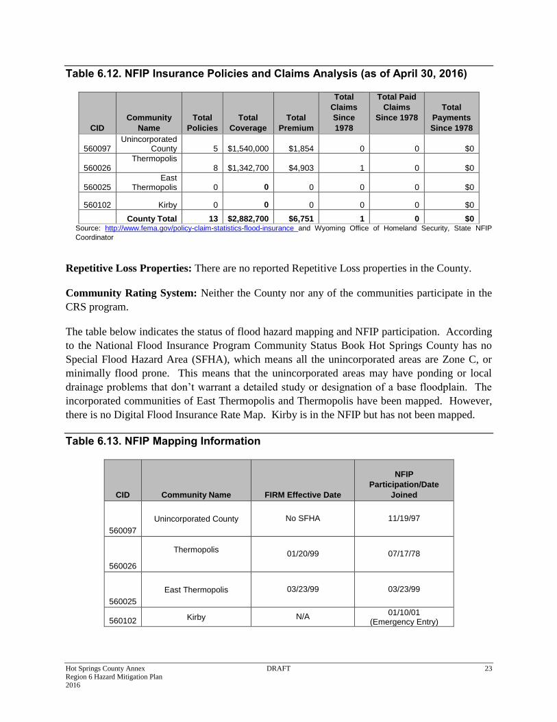
Table 6.12. NFIP Insurance Policies and Claims Analysis (as of April 30, 2016)
CID
Community
Name
Total
Policies
Total
Coverage
Total
Premium
Total
Claims
Since
1978
Total Paid
Claims
Since 1978
Total
Payments
Since 1978
560097 Unincorporated
County 5 $1,540,000 $1,854 0 0 $0
560026 Thermopolis
8 $1,342,700 $4,903 1 0 $0
560025 East
Thermopolis 0 0 0 0 0 $0
560102 Kirby 0 0 0 0 0 $0
County Total 13 $2,882,700 $6,751 1 0 $0 Source: http://www.fema.gov/policy-claim-statistics-flood-insurance and Wyoming Office of Homeland Security, State NFIP
Coordinator
Repetitive Loss Properties: There are no reported Repetitive Loss properties in the County.
Community Rating System: Neither the County nor any of the communities participate in the
CRS program.
The table below indicates the status of flood hazard mapping and NFIP participation. According
to the National Flood Insurance Program Community Status Book Hot Springs County has no
Special Flood Hazard Area (SFHA), which means all the unincorporated areas are Zone C, or
minimally flood prone. This means that the unincorporated areas may have ponding or local
drainage problems that don’t warrant a detailed study or designation of a base floodplain. The
incorporated communities of East Thermopolis and Thermopolis have been mapped. However,
there is no Digital Flood Insurance Rate Map. Kirby is in the NFIP but has not been mapped.
Table 6.13. NFIP Mapping Information
CID Community Name FIRM Effective Date
NFIP
Participation/Date
Joined
560097
Unincorporated County No SFHA 11/19/97
560026
Thermopolis
01/20/99 07/17/78
560025
East Thermopolis 03/23/99 03/23/99
560102 Kirby N/A 01/10/01
(Emergency Entry)
Hot Springs County Annex DRAFT 24 Region 6 Hazard Mitigation Plan 2016
6.3.8 Hail
Vulnerability to hail is not noticeably different from the rest of the region. Refer to Chapter 4 for
a discussion of hail risk related to Hot Springs County and the Region. Members of the HMPC
noted that the 1982 hail storm had significant impacts which also impacted the Hot Springs State
Park.
6.3.9 Hazardous Materials
Hazardous materials vulnerability is significant in the County for transportation accidents due to
the highways and railroad that passes through the County and all municipalities. Hazardous
Materials facilities are listed in the Critical Facilities section of this annex in Section 2.7.2. Refer
to Chapter 4 for a discussion of hazardous materials risk in the Region and County. The HMPC
also noted that the railroad and pipelines pose a major concern. The County LEPC has an inventory
of rail transported hazardous materials, but no commodity flow study related to the highway.
Given the highway and railroad proximity to Thermopolis and East Thermopolis these
municipalities have a high vulnerability to hazardous materials incidents.
6.3.10 High Wind
Refer to Chapter 4 for a discussion of wind risk related to Hot Springs County and the Region.
6.3.11 Landslide, Debris Flow and Rockfall
Hot Springs County has a higher hazard significance rating for landslides than most counties in
the region reflecting high risk to transportation (highway and rail) and travelling public in Wind
River Canyon and economic impacts of highway and rail closures due to landslides. During the
Hot Springs County Risk Assessment and Goals Meeting, members of the HMPC noted the
following consequences of landslides:
GIS analysis did not indicate risk to existing development but planning committee noted that
slumps are near six or more houses in Wind River Canyon, near Wolf Creek;
Regional economic impacts from landslides can be substantial. The highway in the Wind River
Canyon was closed for 3 days in May 2015 during Memorial Day weekend;
The landslides and debris flows in May 2015 damaged train tracks and blocked the highway
for a few days.
Another incident in the Canyon caused a train derailment May 2010. Crew was transported to
hospital with hypothermia from being in the river. The derailment was caused by a boulder on
the track.
Also has the potential to trigger a transportation hazardous materials incident.
Hot Springs County Annex DRAFT 25 Region 6 Hazard Mitigation Plan 2016
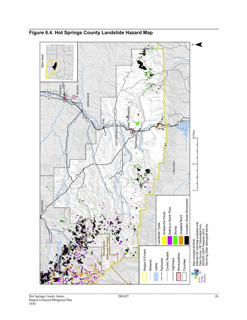
Below is a map of landslide hazards in Hot Springs County. Additional details on these mapped
landslide areas can be referenced in the Region 6 Landslide Appendix (Appendix B) by USGS
quadrangle.
While the risk is primarily in the unincorporated areas the municipalities are all vulnerable to
indirect impacts of landslides when the highway or railroad is impacted.
Hot Springs County Annex DRAFT 26 Region 6 Hazard Mitigation Plan 2016
Figure 6.4. Hot Springs County Landslide Hazard Map
Hot Springs County Annex DRAFT 27 Region 6 Hazard Mitigation Plan 2016
One major highway and six county roads in the County intersect landslide areas, as noted in the
table below. Landslide, rockfall and debris flow mitigation in the Wind River Canyon on WY 789
has been a priority of WYDOT. According to WYDOT representative on the HMPC they have
17 areas undergoing further investigation but do not currently have the funding to address all
needed mitigation.
Table 6.14. Highways Intersecting Landslide Hazard Areas
County Road Type Road Name Segment Count Length (ft.) Length (m)
Hot Springs
County Road CR 36 1 1,692 0.3
County Road CR 4 1 1,103 0.2
County Road CR 5 9 6,579 1.2
County Road CR 7 3 5,023 1.0
State Highway WY 789 7 7,498 1.4
Total 21 21,895 4.1
Critical Facility Analysis
A GIS analysis of critical facilities did not identify any located within landslide hazard areas. The
Thermopolis water plant is near a stabilized landslide that has potential for future movement
according to a geologist present at a public meeting.
6.3.12 Lightning
Vulnerability to lightning is not noticeably different from the rest of the region. The HMPC noted
the following regarding this hazard in Hot Springs County:
Communications towers are grounded, as are some substations; and
Lightning Detection/Monitoring by Federal Government (BLM/Interagency) helps mitigate
wildfire starts by sending maps to fire departments.
6.3.13 Mine Subsidence
During the Hot Springs County Risk Assessment and Goals Meeting, members of the HMPC
commented that there are some areas of mine and natural subsidence in Hot Springs County.
The Gebo mine area has been reclaimed per the Wyoming Geological Survey;
Natural sinkholes in limestone at Legend Rock, golf course, and Anchor Dam; and
While not a subsidence hazard per se, a potential public safety hazards exist with cisterns in
certain areas. These are typically 20’ deep by 5’ wide.
Hot Springs County Annex DRAFT 28 Region 6 Hazard Mitigation Plan 2016
6.3.14 Tornado
The HMPC noted that while tornadoes occur in the county, they historically occur in undeveloped
areas and are not very strong. Refer to Chapter 4 for a discussion of tornado risk related to the
Region.
6.3.15 Wildfire
Wildfire is a high significance hazard for the County, consistent with other counties in the Region.
The Hot Springs County HMPC, however, noted that the WUI is not as extensive as other parts of
Wyoming as many of the forested areas are not inhabited. The group noted that Cottonwood
Ventures subdivision in the unincorporated county having the highest risk and highest value homes
in the WUI. Range land and grass fires can be a threat both to property and livestock and can also
allow invasive species to spread. Thermopolis has been threatened by wildfire in the past. The
railroad has also seen impacts from fires. Other impacts include air quality, even from fires
hundreds of miles away.
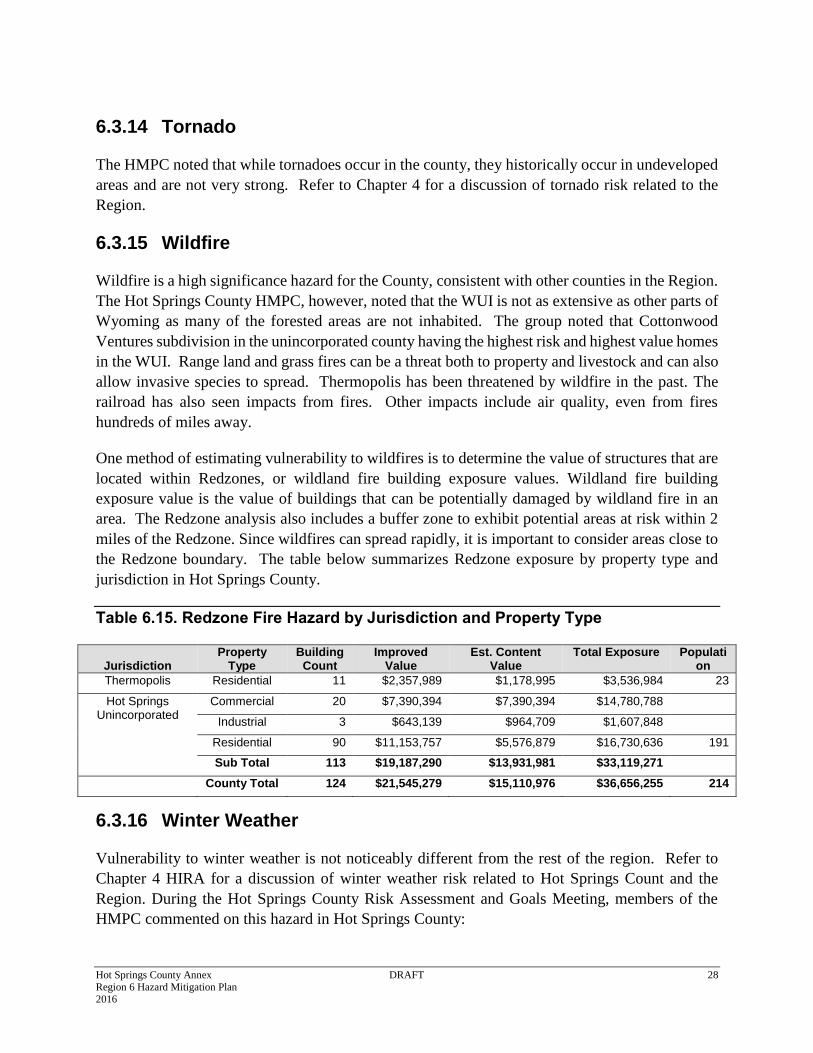
One method of estimating vulnerability to wildfires is to determine the value of structures that are
located within Redzones, or wildland fire building exposure values. Wildland fire building
exposure value is the value of buildings that can be potentially damaged by wildland fire in an
area. The Redzone analysis also includes a buffer zone to exhibit potential areas at risk within 2
miles of the Redzone. Since wildfires can spread rapidly, it is important to consider areas close to
the Redzone boundary. The table below summarizes Redzone exposure by property type and
jurisdiction in Hot Springs County.
Table 6.15. Redzone Fire Hazard by Jurisdiction and Property Type
Jurisdiction Property
Type Building
Count Improved
Value Est. Content
Value Total Exposure Populati
on
Thermopolis Residential 11 $2,357,989 $1,178,995 $3,536,984 23
Hot Springs Unincorporated
Commercial 20 $7,390,394 $7,390,394 $14,780,788
Industrial 3 $643,139 $964,709 $1,607,848
Residential 90 $11,153,757 $5,576,879 $16,730,636 191
Sub Total 113 $19,187,290 $13,931,981 $33,119,271
County Total 124 $21,545,279 $15,110,976 $36,656,255 214
6.3.16 Winter Weather
Vulnerability to winter weather is not noticeably different from the rest of the region. Refer to
Chapter 4 HIRA for a discussion of winter weather risk related to Hot Springs Count and the
Region. During the Hot Springs County Risk Assessment and Goals Meeting, members of the
HMPC commented on this hazard in Hot Springs County:
Hot Springs County Annex DRAFT 29 Region 6 Hazard Mitigation Plan 2016
Power failures have occurred and caused occasional facility damage;
2014 shed and roof damage; there are a number of flat roofed buildings in the County;
East Thermopolis has been undergrounding utilities to help mitigate impacts; and
Tree damage has also been an issue
6.4 Mitigation Capabilities Assessment
As part of the regional plan development, the Region and participating jurisdictions developed a
mitigation capability assessment. Capabilities are those plans, policies and procedures that are
currently in place that contribute to reducing hazard losses. Combining the risk assessment with
the mitigation capability assessment results in “net vulnerability” to disasters and more accurately
focuses the goals, objectives, and proposed actions of this plan. The HMPC used a two-step
approach to conduct this assessment. First, an inventory of common mitigation activities was made
through the use of a matrix. The purpose of this effort was to identify policies and programs that
were either in place or could be undertaken, if appropriate. Second, the HMPC conducted an
inventory and review of existing policies, regulations, plans, projects, and programs to determine
if they contribute to reducing hazard related losses.
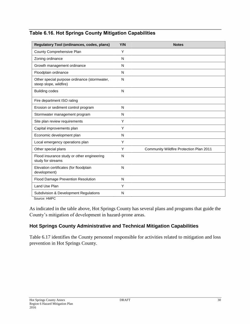
6.4.1 Hot Springs County Regulatory Mitigation Capabilities
Table 6.16 lists planning and land management tools typically used by local jurisdictions to
implement hazard mitigation activities and indicates those that are in place in Hot Springs County.
Excerpts from applicable policies, regulations, plans and programs descriptions follow to provide
more detail on existing mitigation capabilities.
Hot Springs County Annex DRAFT 30 Region 6 Hazard Mitigation Plan 2016
Table 6.16. Hot Springs County Mitigation Capabilities
Regulatory Tool (ordinances, codes, plans) Y/N Notes
County Comprehensive Plan Y
Zoning ordinance N
Growth management ordinance N
Floodplain ordinance N
Other special purpose ordinance (stormwater,
steep slope, wildfire)
N
Building codes N
Fire department ISO rating
Erosion or sediment control program N
Stormwater management program N
Site plan review requirements Y
Capital improvements plan Y
Economic development plan N
Local emergency operations plan Y
Other special plans Y Community Wildfire Protection Plan 2011
Flood insurance study or other engineering
study for streams
N
Elevation certificates (for floodplain
development)
N
Flood Damage Prevention Resolution N
Land Use Plan Y
Subdivision & Development Regulations N
Source: HMPC
As indicated in the table above, Hot Springs County has several plans and programs that guide the
County’s mitigation of development in hazard-prone areas.
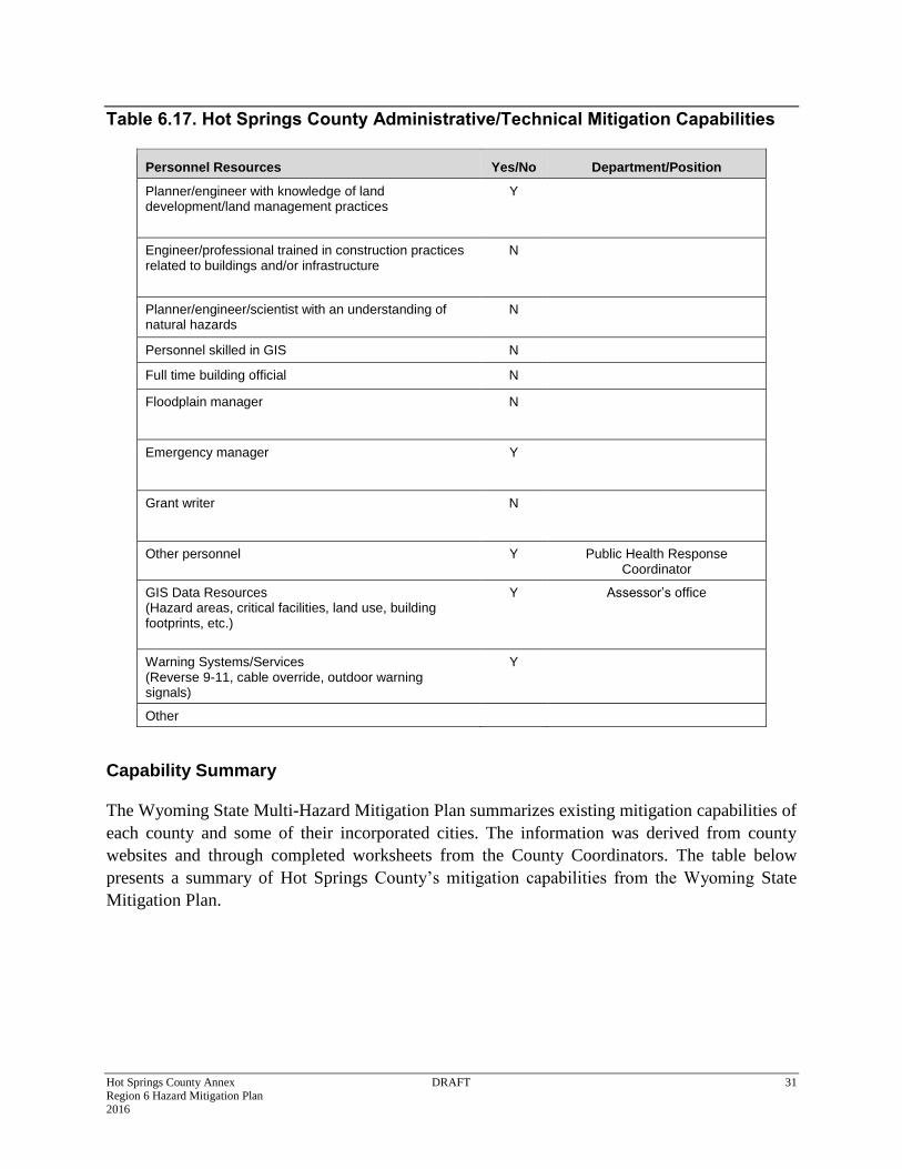
Hot Springs County Administrative and Technical Mitigation Capabilities
Table 6.17 identifies the County personnel responsible for activities related to mitigation and loss
prevention in Hot Springs County.
Hot Springs County Annex DRAFT 31 Region 6 Hazard Mitigation Plan 2016
Table 6.17. Hot Springs County Administrative/Technical Mitigation Capabilities
Personnel Resources Yes/No Department/Position
Planner/engineer with knowledge of land development/land management practices
Y
Engineer/professional trained in construction practices related to buildings and/or infrastructure
N
Planner/engineer/scientist with an understanding of natural hazards
N
Personnel skilled in GIS N
Full time building official N
Floodplain manager N
Emergency manager Y
Grant writer N
Other personnel Y Public Health Response Coordinator
GIS Data Resources (Hazard areas, critical facilities, land use, building footprints, etc.)
Y Assessor’s office
Warning Systems/Services (Reverse 9-11, cable override, outdoor warning signals)
Y
Other
Capability Summary
The Wyoming State Multi-Hazard Mitigation Plan summarizes existing mitigation capabilities of
each county and some of their incorporated cities. The information was derived from county
websites and through completed worksheets from the County Coordinators. The table below
presents a summary of Hot Springs County’s mitigation capabilities from the Wyoming State
Mitigation Plan.
Hot Springs County Annex DRAFT 32 Region 6 Hazard Mitigation Plan 2016
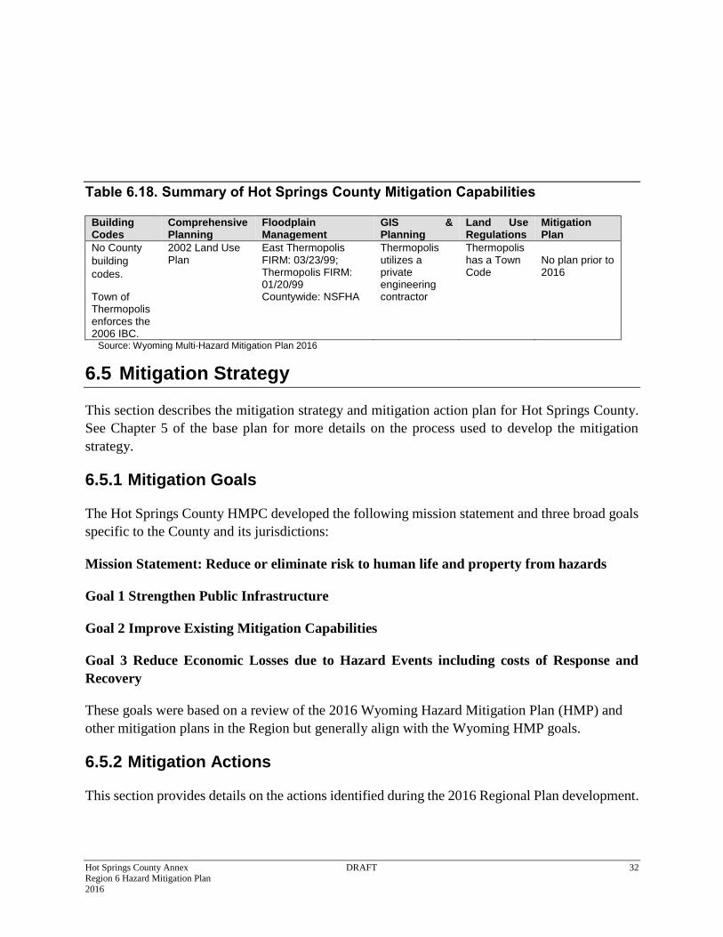
Table 6.18. Summary of Hot Springs County Mitigation Capabilities
Building Codes
Comprehensive Planning
Floodplain Management
GIS & Planning
Land Use Regulations
Mitigation Plan
No County
building
codes.
Town of Thermopolis enforces the 2006 IBC.
2002 Land Use Plan
East Thermopolis FIRM: 03/23/99; Thermopolis FIRM: 01/20/99 Countywide: NSFHA
Thermopolis utilizes a private engineering contractor
Thermopolis has a Town Code
No plan prior to 2016
Source: Wyoming Multi-Hazard Mitigation Plan 2016
6.5 Mitigation Strategy
This section describes the mitigation strategy and mitigation action plan for Hot Springs County.
See Chapter 5 of the base plan for more details on the process used to develop the mitigation
strategy.
6.5.1 Mitigation Goals
The Hot Springs County HMPC developed the following mission statement and three broad goals
specific to the County and its jurisdictions:
Mission Statement: Reduce or eliminate risk to human life and property from hazards
Goal 1 Strengthen Public Infrastructure
Goal 2 Improve Existing Mitigation Capabilities
Goal 3 Reduce Economic Losses due to Hazard Events including costs of Response and
Recovery
These goals were based on a review of the 2016 Wyoming Hazard Mitigation Plan (HMP) and
other mitigation plans in the Region but generally align with the Wyoming HMP goals.
6.5.2 Mitigation Actions
This section provides details on the actions identified during the 2016 Regional Plan development.
Hot Springs County Annex DRAFT 33 Region 6 Hazard Mitigation Plan 2016
As a part of the 2016 regional planning process, the HMPC developed a list of hazard mitigation
actions or projects specific to Hot Springs County and its jurisdictions. The process used to
identify, develop and prioritize these actions is described in Chapter 5 of the base plan. Listed
below are the proposed actions, the hazards they intend to mitigate, jurisdiction specifics, primary
agencies, priority, and estimated timeframe and costs involved. Per the DMA requirement, actions
have been identified that address reducing losses to existing development as well as future
development. Those that reduce losses to future development are indicated by an asterisk (*) in
the “Proposed Mitigation Action Description” column in Table 5.1. Also important to reducing
losses to future development is continued compliance with the NFIP. The jurisdictions that
participate in the NFIP (County, Thermopolis, East Thermopolis, and Kirby) will continue to make
every effort to remain in good standing with the program. This includes continuing to comply
with the NFIP in regards to adopting floodplain maps and implementing, maintaining and updating
floodplain ordinances. See Section 5.4.2 in the base plan for more discussion on NFIP compliance.
Related to this is the need for better floodplain mapping to support floodplain management which
is noted in a specific action in the following table.
Hot Springs County Annex DRAFT 34 Region 6 Hazard Mitigation Plan 2016
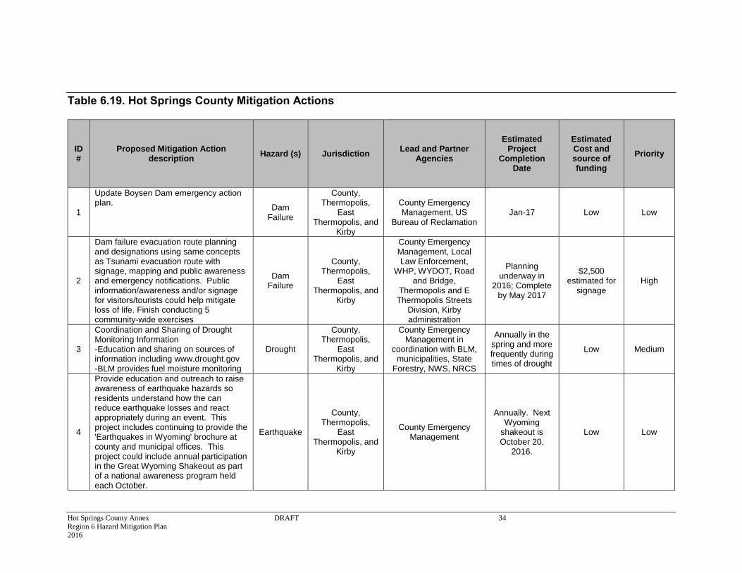
Table 6.19. Hot Springs County Mitigation Actions
ID #
Proposed Mitigation Action description
Hazard (s) Jurisdiction Lead and Partner
Agencies
Estimated Project
Completion Date
Estimated Cost and source of funding
Priority
1
Update Boysen Dam emergency action plan.
Dam Failure
County, Thermopolis,
East Thermopolis, and
Kirby
County Emergency Management, US
Bureau of Reclamation Jan-17 Low Low
2
Dam failure evacuation route planning and designations using same concepts as Tsunami evacuation route with signage, mapping and public awareness and emergency notifications. Public information/awareness and/or signage for visitors/tourists could help mitigate loss of life. Finish conducting 5 community-wide exercises
Dam Failure
County, Thermopolis,
East Thermopolis, and
Kirby
County Emergency Management, Local Law Enforcement,
WHP, WYDOT, Road and Bridge,
Thermopolis and E Thermopolis Streets
Division, Kirby administration
Planning underway in
2016; Complete by May 2017
$2,500 estimated for
signage High
3
Coordination and Sharing of Drought Monitoring Information -Education and sharing on sources of information including www.drought.gov -BLM provides fuel moisture monitoring
Drought
County, Thermopolis,
East Thermopolis, and
Kirby
County Emergency Management in
coordination with BLM, municipalities, State
Forestry, NWS, NRCS
Annually in the spring and more frequently during times of drought
Low Medium
4
Provide education and outreach to raise awareness of earthquake hazards so residents understand how the can reduce earthquake losses and react appropriately during an event. This project includes continuing to provide the 'Earthquakes in Wyoming' brochure at county and municipal offices. This project could include annual participation in the Great Wyoming Shakeout as part of a national awareness program held each October.
Earthquake
County, Thermopolis,
East Thermopolis, and
Kirby
County Emergency Management
Annually. Next Wyoming
shakeout is October 20,
2016.
Low Low
Hot Springs County Annex DRAFT 35 Region 6 Hazard Mitigation Plan 2016
ID #
Proposed Mitigation Action description
Hazard (s) Jurisdiction Lead and Partner
Agencies
Estimated Project
Completion Date
Estimated Cost and source of funding
Priority
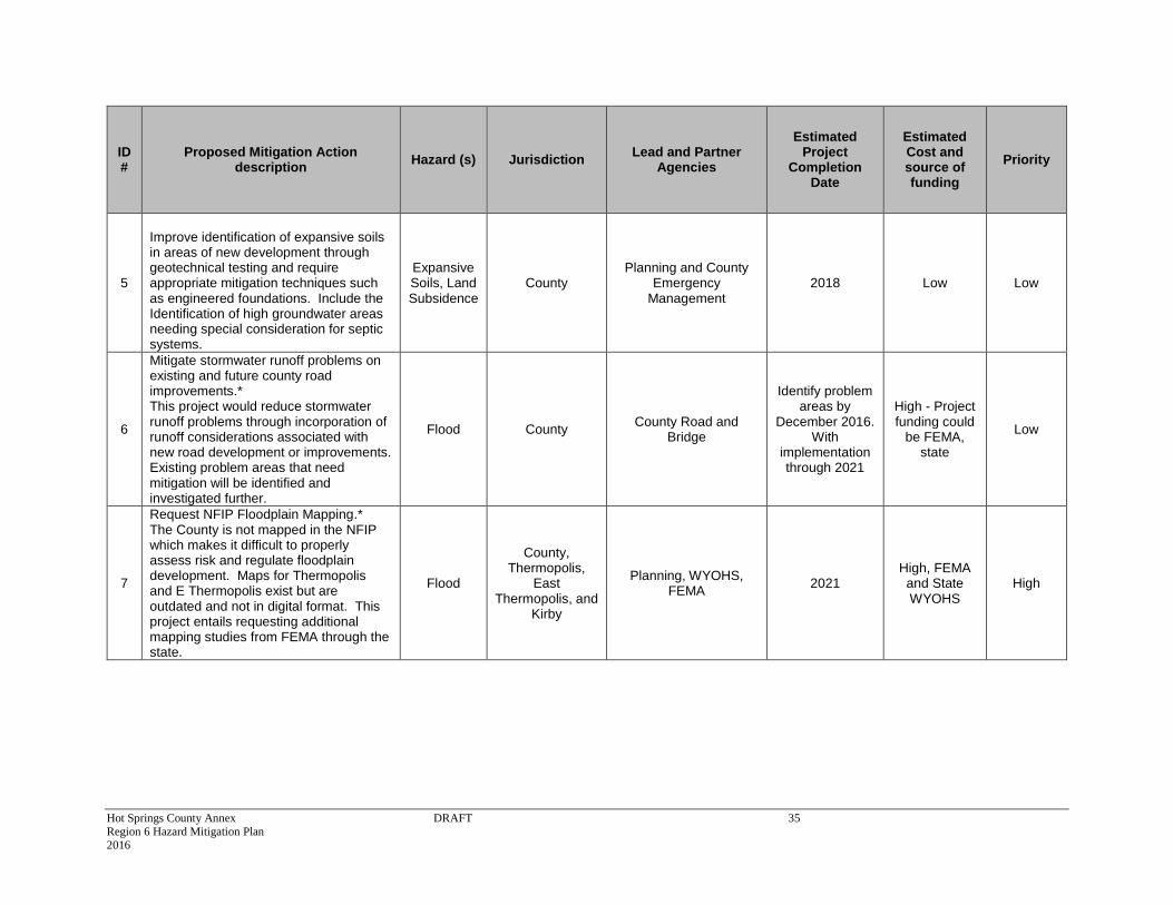
5
Improve identification of expansive soils in areas of new development through geotechnical testing and require appropriate mitigation techniques such as engineered foundations. Include the Identification of high groundwater areas needing special consideration for septic systems.
Expansive Soils, Land Subsidence
County Planning and County
Emergency Management
2018 Low Low
6
Mitigate stormwater runoff problems on existing and future county road improvements.* This project would reduce stormwater runoff problems through incorporation of runoff considerations associated with new road development or improvements. Existing problem areas that need mitigation will be identified and investigated further.
Flood County County Road and
Bridge
Identify problem areas by
December 2016. With
implementation through 2021
High - Project funding could
be FEMA, state
Low
7
Request NFIP Floodplain Mapping.* The County is not mapped in the NFIP which makes it difficult to properly assess risk and regulate floodplain development. Maps for Thermopolis and E Thermopolis exist but are outdated and not in digital format. This project entails requesting additional mapping studies from FEMA through the state.
Flood
County, Thermopolis,
East Thermopolis, and
Kirby
Planning, WYOHS, FEMA
2021 High, FEMA and State WYOHS
High
Hot Springs County Annex DRAFT 36 Region 6 Hazard Mitigation Plan 2016
ID #
Proposed Mitigation Action description
Hazard (s) Jurisdiction Lead and Partner
Agencies
Estimated Project
Completion Date
Estimated Cost and source of funding
Priority
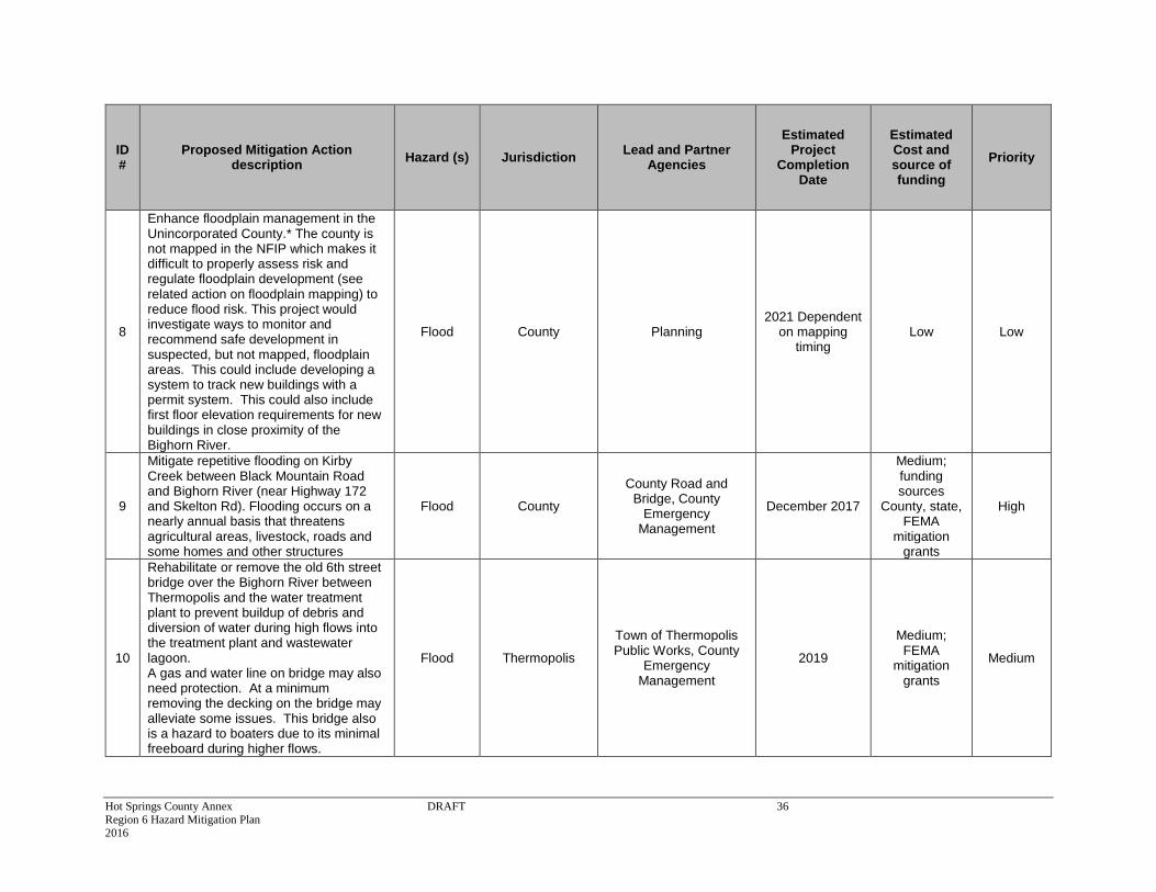
8
Enhance floodplain management in the Unincorporated County.* The county is not mapped in the NFIP which makes it difficult to properly assess risk and regulate floodplain development (see related action on floodplain mapping) to reduce flood risk. This project would investigate ways to monitor and recommend safe development in suspected, but not mapped, floodplain areas. This could include developing a system to track new buildings with a permit system. This could also include first floor elevation requirements for new buildings in close proximity of the Bighorn River.
Flood County Planning 2021 Dependent
on mapping timing
Low Low
9
Mitigate repetitive flooding on Kirby Creek between Black Mountain Road and Bighorn River (near Highway 172 and Skelton Rd). Flooding occurs on a nearly annual basis that threatens agricultural areas, livestock, roads and some homes and other structures
Flood County
County Road and Bridge, County
Emergency Management
December 2017
Medium; funding sources
County, state, FEMA
mitigation grants
High
10
Rehabilitate or remove the old 6th street bridge over the Bighorn River between Thermopolis and the water treatment plant to prevent buildup of debris and diversion of water during high flows into the treatment plant and wastewater lagoon. A gas and water line on bridge may also need protection. At a minimum removing the decking on the bridge may alleviate some issues. This bridge also is a hazard to boaters due to its minimal freeboard during higher flows.
Flood Thermopolis
Town of Thermopolis Public Works, County
Emergency Management
2019
Medium; FEMA
mitigation grants
Medium
Hot Springs County Annex DRAFT 37 Region 6 Hazard Mitigation Plan 2016
ID #
Proposed Mitigation Action description
Hazard (s) Jurisdiction Lead and Partner
Agencies
Estimated Project
Completion Date
Estimated Cost and source of funding
Priority
11
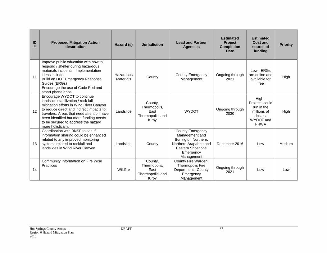
Improve public education with how to respond / shelter during hazardous materials incidents. Implementation ideas include: Build on DOT Emergency Response Guides (ERGs) Encourage the use of Code Red and smart phone apps.
Hazardous Materials
County County Emergency
Management Ongoing through
2021
Low - ERGs are online and available for
free
High
12
Encourage WYDOT to continue landslide stabilization / rock fall mitigation efforts in Wind River Canyon to reduce direct and indirect impacts to travelers. Areas that need attention have been identified but more funding needs to be secured to address the hazard more holistically.
Landslide
County, Thermopolis,
East Thermopolis, and
Kirby
WYDOT Ongoing through
2030
High - Projects could
run in the millions of
dollars. WYDOT and
FHWA
High
13
Coordination with BNSF to see if information sharing could be enhanced related to any improved monitoring systems related to rockfall and landslides in Wind River Canyon
Landslide County
County Emergency Management and
Burlington Northern, Northern Arapahoe and
Eastern Shoshone Emergency
Management
December 2016 Low Medium
14
Community Information on Fire Wise Practices
Wildfire
County, Thermopolis,
East Thermopolis, and
Kirby
County Fire Warden, Thermopolis Fire
Department, County Emergency
Management
Ongoing through 2021
Low Low
Hot Springs County Annex DRAFT 38 Region 6 Hazard Mitigation Plan 2016
ID #
Proposed Mitigation Action description
Hazard (s) Jurisdiction Lead and Partner
Agencies
Estimated Project
Completion Date
Estimated Cost and source of funding
Priority
15
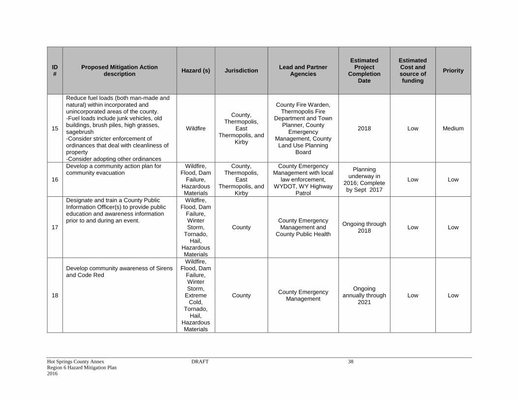
Reduce fuel loads (both man-made and natural) within incorporated and unincorporated areas of the county. -Fuel loads include junk vehicles, old buildings, brush piles, high grasses, sagebrush -Consider stricter enforcement of ordinances that deal with cleanliness of property -Consider adopting other ordinances
Wildfire
County, Thermopolis,
East Thermopolis, and
Kirby
County Fire Warden, Thermopolis Fire
Department and Town Planner, County
Emergency Management, County Land Use Planning
Board
2018 Low Medium
16
Develop a community action plan for community evacuation
Wildfire, Flood, Dam
Failure, Hazardous Materials
County, Thermopolis,
East Thermopolis, and
Kirby
County Emergency Management with local
law enforcement, WYDOT, WY Highway
Patrol
Planning underway in
2016; Complete by Sept 2017
Low Low
17
Designate and train a County Public Information Officer(s) to provide public education and awareness information prior to and during an event.
Wildfire, Flood, Dam
Failure, Winter Storm,
Tornado, Hail,
Hazardous Materials
County County Emergency Management and
County Public Health
Ongoing through 2018
Low Low
18
Develop community awareness of Sirens and Code Red
Wildfire, Flood, Dam
Failure, Winter Storm,
Extreme Cold,
Tornado, Hail,
Hazardous Materials
County County Emergency
Management
Ongoing annually through
2021 Low Low
Hot Springs County Annex DRAFT 39 Region 6 Hazard Mitigation Plan 2016
ID #
Proposed Mitigation Action description
Hazard (s) Jurisdiction Lead and Partner
Agencies
Estimated Project
Completion Date
Estimated Cost and source of funding
Priority
19
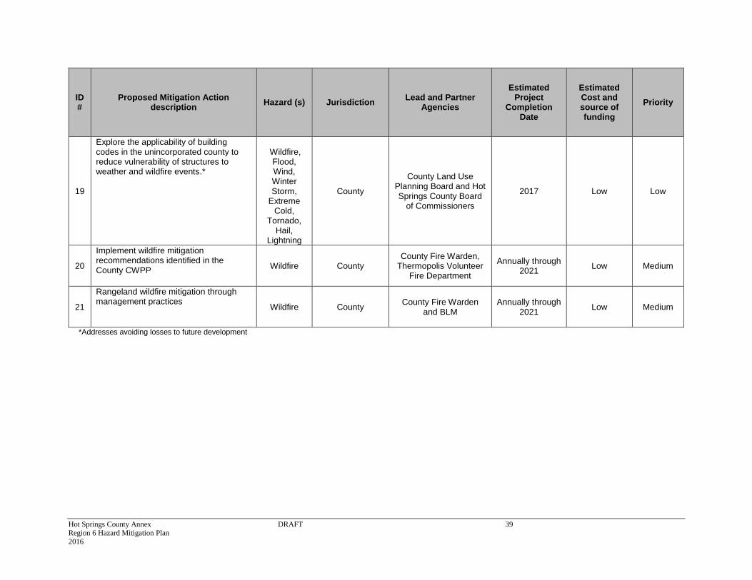
Explore the applicability of building codes in the unincorporated county to reduce vulnerability of structures to weather and wildfire events.*
Wildfire,
Flood, Wind, Winter Storm,
Extreme Cold,
Tornado, Hail,
Lightning
County
County Land Use Planning Board and Hot Springs County Board
of Commissioners
2017 Low Low
20
Implement wildfire mitigation recommendations identified in the County CWPP
Wildfire County County Fire Warden,
Thermopolis Volunteer Fire Department
Annually through 2021
Low Medium
21
Rangeland wildfire mitigation through management practices
Wildfire County County Fire Warden
and BLM Annually through
2021 Low Medium
*Addresses avoiding losses to future development

Hot Springs County Annex DRAFT 40 Region 6 Hazard Mitigation Plan 2016
6.5.3 Implementation
Moving forward the Hot Springs County HMPC will use the mitigation action table in the previous
section to track progress on implementation of each project. Implementation of the plan overall
is discussed in Chapter 6.
Incorporation into Existing Planning Mechanisms
Also discussed in Chapter 6 is the importance of implementation and incorporation of the
principles of this plan into other planning mechanisms.
As described in the capability assessment, the County already implements policies and programs
to reduce losses to life and property from hazards. This plan builds upon the momentum developed
through previous and related planning efforts and mitigation programs and recommends
implementing actions, where possible, through these other program mechanisms. Where
applicable, these existing mechanisms could include:
County or community comprehensive plans
County or community development codes
County or community Emergency Operations Plans
Threat and Hazard Identification and Risk Assessments (THIRA)
Community Wildfire Protection Plan (CWPP)
Capital improvement plans and budgets
Recovery planning efforts
Watershed planning efforts
Wildfire planning efforts on adjacent public lands
Master planning efforts
River corridor planning efforts
Hot Springs State Park Master Plan
WYDOT Wind River Canyon rockfall and landslide mitigation
Other plans, regulations, and practices with a mitigation aspect
The process for incorporation of the Regional Hazard Mitigation Plan into other planning
mechanisms can be as simple as cross-referencing the Hazard Mitigation Plan where applicable.
Integrated planning is a key to building community resiliency.