Embed Size (px)
Citation preview
HONEYMOON ISLAND STATE PARK
UNIT MANAGEMENT PLAN
APPROVED
STATE OF FLORIDA DEPARTMENT OF ENVIRONMENTAL PROTECTION
Division of Recreation and Parks
June 15, 2007

i
TABLE OF CONTENTS
INTRODUCTION.....................................................................................................................1
PURPOSE AND SCOPE OF PLAN .......................................................................................1
MANAGEMENT PROGRAM OVERVIEW ........................................................................5
Management Authority and Responsibility ........................................................................5
Park Goals and Objectives......................................................................................................6
Management Coordination ....................................................................................................8
Public Participation .................................................................................................................9
Other Designations..................................................................................................................9
RESOURCE MANAGEMENT COMPONENT
INTRODUCTION...................................................................................................................11
RESOURCE DESCRIPTION AND ASSESSMENT.........................................................11
Natural Resources .................................................................................................................11
Cultural Resources ................................................................................................................20
RESOURCE MANAGEMENT PROGRAM ......................................................................21
Special Management Considerations .................................................................................21
Management Needs and Problems .....................................................................................22
Management Objectives .......................................................................................................24
Management Measures For Natural Resources ................................................................26
Management Measures For Cultural Resources ...............................................................31
Research Needs......................................................................................................................32
Resource Management Schedule.........................................................................................32
Land Management Review ..................................................................................................33
ii
LAND USE COMPONENT
INTRODUCTION...................................................................................................................35
EXTERNAL CONDITIONS..................................................................................................35
Existing Use of Adjacent Lands...........................................................................................36
Planned Use of Adjacent Lands...........................................................................................37
PROPERTY ANALYSIS.........................................................................................................37
Recreation Resource Elements.............................................................................................37
Assessment of Use .................................................................................................................39
CONCEPTUAL LAND USE PLAN .....................................................................................42
Potential Uses and Proposed Facilities...............................................................................44
Facilities Development..........................................................................................................46
Existing Use and Optimum Carrying Capacity ................................................................47
Optimum Boundary ..............................................................................................................47
TABLE
TABLE 1 - Existing Use and Optimum Carrying Capacity...............................................48
LIST OF ADDENDA
ADDENDUM 1
Acquisition History and Advisory Group Documentation ................................. A 1 - 1
ADDENDUM 2
References Cited ......................................................................................................... A 2 - 1 ADDENDUM 3
Soil Descriptions ......................................................................................................... A 3 - 1

iii
ADDENDUM 4
Plant and Animal List ................................................................................................ A 4 - 1
ADDENDUM 5
Designated Species List ............................................................................................. A 5 - 1
ADDENDUM 6
Priority Schedule and Cost Estimates...................................................................... A 6 - 1
ADDITIONAL INFORMATION
FNAI Descriptions of Natural Communities ......................................................................1
DHR Cultural Management Procedures..............................................................................9
2003 Land Management Review Report ............................................................................19
MAPS
Vicinity Map ...............................................................................................................................2
Reference Map............................................................................................................................3
Soils Map ...................................................................................................................................13
Natural Communities Map ....................................................................................................15
Burn Zone Map ........................................................................................................................27
Base Map ...................................................................................................................................40
Conceptual Land Use Plan .....................................................................................................43
1
INTRODUCTION
Honeymoon Island State Park is located in Pinellas County about four miles northwest of downtown Dunedin, and about two miles from the mainland shoreline. The island is part of a chain of barrier islands that parallels Florida’s Gulf Coast. The island has been accessible from the mainland via highway State Road 586 and the Dunedin Causeway since 1965 (see Vicinity and Reference Maps). St. Joseph Sound, an extensive body of water managed as a part of the 336,265-acre Pinellas County Aquatic Preserve, lies between the island and the mainland. A small mangrove island, called Grassy Key, lies off the eastern shore of Honeymoon Island. Several other significant land and water resources exist near the park. They include Caladesi Island State Park, Anclote Key Preserve State Park, Werner Boyce- Salt Springs State Park, Pinellas County Aquatic Preserve, Brooker Creek Preserve, owned by Pinellas County and The Hammock, which is owned by the City of Dunedin. Acquisition of the barrier island began in 1974, after the failure of an extensive commercial development scheme of high-density dwellings, (Luisi, 1999). Initially, funds from the 1972 sale of general obligation bonds were used. Later purchases were made with funds from the Land Acquisition Trust Fund. Currently the park contains approximately 2,810.16 acres. The park is the location of the administrative office for the following parks: Egmont Key State Park, Skyway Fishing Piers State Park, Caladesi Island State Park and Anclote Key Preserve State Park. At Honeymoon Island State Park, public outdoor recreation is the designated single use of the property (see Addendum 1). There are no legislative or executive directives that constrain the use of this property. Honeymoon Island State Park is a favorite destination for beach recreation and nature study. It consistently ranks among the top five most visited parks in the Florida State Parks system.
PURPOSE AND SCOPE OF THE PLAN
This plan serves as the basic statement of policy and direction for the management of Honeymoon Island State Park as a unit of Florida's state park system. It identifies the objectives, criteria and standards that guide each aspect of park administration, and sets forth the specific measures that will be implemented to meet management objectives. The plan is intended to meet the requirements of Sections 253.034 and 259.032, Florida Statutes, Chapter 18-2, Florida Administrative Code, and intended to be consistent with the State Lands Management Plan. With approval, this management plan will replace the October 31, 1999, approved plan. All development and resource alteration encompassed in this plan is subject to the granting of appropriate permits; easements, licenses, and other required legal instruments. Approval of the management plan does


4
not constitute an exemption from complying with the appropriate local, state or federal agencies. This plan is also intended to meet the requirements for beach and shore preservation, as defined in Chapter 161, Florida Statutes and Chapters 62B-33, 62B-36 and 62R-49, Florida Administrative Code. The plan consists of two interrelated components. Each component corresponds to a particular aspect of the administration of the park. The resource management component provides a detailed inventory and assessment of the natural and cultural resources of the park. Resource management problems and needs are identified, and specific management objectives are established for each resource type. This component provides guidance on the application of such measures as prescribed burning, exotic species removal and restoration of natural conditions. The land use component is the recreational resource allocation plan for the unit. Based on considerations such as access, population and adjacent land uses, an optimum allocation of the physical space of the park is made, locating use areas and proposing types of facilities and volume of use to be provided. In the development of this plan, the potential of the park to accommodate secondary management purposes (“multiple uses”) was analyzed. These secondary purposes were considered within the context of the Division’s statutory responsibilities and an analysis of the resource needs and values of the park. This analysis considered the park natural and cultural resources, management needs, aesthetic values, visitation and visitor experiences. For this park, it was determined that no secondary purposes could be accommodated in a manner that would not interfere with the primary purpose of resource-based outdoor recreation and conservation. Uses such as, water resource development projects, water supply projects, stormwater management projects, linear facilities and sustainable agriculture and forestry (other than those forest management activities specifically identified in this plan) are not consistent with this plan or the management purposes of the park and should be discouraged. The potential for generating revenue to enhance management was also analyzed. Visitor fees and charges are the principal source of revenue generated by the park. It was determined that multiple-use management activities would not be appropriate as a means of generating revenues for land management. Instead, techniques such as entrance fees, concessions and similar measures will be employed on a case-by-case basis as a means of supplementing park management funding. The use of private land managers to facilitate restoration and management of this unit was also analyzed. Decisions regarding this type of management (such as outsourcing, contracting with the private sector, use of volunteers, etc.) will be made on a case-by-case basis as necessity dictates.
5
MANAGEMENT PROGRAM OVERVIEW
Management Authority and Responsibility
In accordance with Chapter 258, Florida Statutes, and Chapter 62D-2, Florida Administrative Code, the Division of Recreation and Parks (DRP) is charged with the responsibility of developing and operating Florida's recreation and parks system. These are administered in accordance with the following policy:
It shall be the policy of the Division of Recreation and Parks to promote the state park system for the use, enjoyment, and benefit of the people of Florida and visitors; to acquire typical portions of the original domain of the state which will be accessible to all of the people, and of such character as to emblemize the state's natural values; conserve these natural values for all time; administer the development, use and maintenance of these lands and render such public service in so doing, in such a manner as to enable the people of Florida and visitors to enjoy these values without depleting them; to contribute materially to the development of a strong mental, moral, and physical fiber in the people; to provide for perpetual preservation of historic sites and memorials of statewide significance and interpretation of their history to the people; to contribute to the tourist appeal of Florida.
The Trustees have also granted management authority of certain sovereign submerged lands to the Division under Management Agreement MA 68-086 (as amended January 19, 1988). The management area includes a 400-foot zone from the edge of mean high water where a park boundary borders sovereign submerged lands fronting beaches, bays, estuarine areas, rivers or streams. Where emergent wetland vegetation exists, the zone extends waterward 400 feet beyond the vegetation. The agreement is intended to provide additional protection to resources of the park and nearshore areas and to provide authority to manage activities that could adversely affect public recreational uses. Many operating procedures are standard system wide and are set by policy. These procedures are outlined in the Division Operations Manual (OM) and cover such areas as personnel management, uniforms and personal appearance, training, signs, communications, fiscal procedures, interpretation, concessions, camping regulations, resource management, law enforcement, protection, safety and maintenance. In the management of Honeymoon Island State Park, emphasis is placed on maximizing the recreational potential of the recreation area; however, preservation of resources remains important. Depletion of a resource by any recreational activity is not permitted. In order to realize the unit's recreational potential, development in the park is aimed at providing facilities that are accessible, convenient and safe, as needed to support recreational use or the unit's natural, aesthetic and educational attributes.
6
Park Goals and Objectives
The following park goals and objectives express the Division’s long-term intent in managing the state park. At the beginning of the process to update this management plan, the Division reviewed the goals and objectives of the previous plan to determine if they remain meaningful and practical and should be included in the updated plan. This process ensures that the goals and objectives for the park remain relevant over time. Estimates are developed for the funding and staff resources needed to implement the management plan based on these goals, objectives and priority management activities. Funding priorities for all state park management and development activities are reviewed each year as part of the Division’s legislative budget process. The Division prepares an annual legislative budget request based on the priorities established for the entire state park system. The Division also aggressively pursues a wide range of other funds and staffing resources, such as grants, volunteers and partnerships with agencies, local governments and the private sector, for supplementing normal legislative appropriations to address unmet needs. The ability of the Division to implement the specific goals, objectives and priority actions identified in this plan will be determined by the availability of funding resources for these purposes.
Natural and Cultural Resources
1. Eradicate invasive exotic plants. A. Continue to remove Australian pine trees when they are found. B. Continue to eradicate Brazilian pepper trees progressively from each burn
zone to maintenance level, and prevent re-establishment in zones where they have been removed.
C. Continue to eradicate exotic grasses from natural communities. 2. Continue to maintain fire-adapted natural communities through prescribed
burning, and continue to restore ruderal areas to native vegetation through prescribed burning and/or replanting. A. Continue the successful burn program in progress, monitoring its restorative
effects in ruderal areas. B. Monitor the re-planting of native vegetation in ruderal areas that are not fire-
type communities, and where the restorative effects of prescribed burning are insufficient. Continue to plant native vegetation where appropriate.
C. Continue to search for a solution to restoring marine unconsolidated substrate, where previous dredge-and-fill operations have created a substrate of limestone pebbles and rocks.
3. Continue to protect shorebird nesting and resting sites, including wintering sites, some of which occur on high-use beaches. A. Continue to prevent disturbance of nesting and wintering shorebirds by
recreational users and their pets through education, interpretation, signs, barriers and law enforcement.

7
B. Educate park visitors by enlisting volunteers to help monitor shorebird nesting activity and using various educational materials.
4. Continue to protect seagrass beds, and monitor their recovery from damage due to propeller scarring and turbidity caused by pollution using guidelines and the best technology in cooperation with Pinellas County Environmental Services and Southwest Florida Water Management District. A. Continue to maintain signs and enlarge scope of educational materials, and
enforcement of combustion engine exclusion zones first permitted in 1993. B. Continue to monitor recovery from scarring and pollution, as well as overall
success of the protection program in partnership with participating agencies. 5. Continue to monitor sea turtle nesting, osprey nesting and wading/shore bird
nesting/resting sites. A. Enlist volunteers, if necessary to assist with monitoring. B. Continue to control terrestrial predators where they are a threat.
6. Assess the impact of nocturnal recreational use on natural resources. A. Assess the usage of nocturnal recreational uses to determine the impact to
nesting sea turtles and nesting/resting shorebirds. B. Assess nocturnal recreational use on a portion of the Gulf beach, and restrict
use if necessary. 7. Identify and protect cultural resources.
A. Conduct a Level I archaeological survey to determine the locations of prehistoric and historic sites.
B. Continue to protect known existing archaeological sites and their associated artifactual assemblage from vandalism, erosion and other forms of encroachment.
C. Interpret cultural resources in their context to educate visitors about Florida’s earlier inhabitants.
D. Determine the location of the cottages and structures from the “Honeymoon” era.
Recreational Goals
8. Continue to provide quality resource based outdoor recreational and interpretive programs and facilities at the state park. A. Continue to provide controlled access for beach recreation. B. Continue to provide visitor education through interpretive programs. C. Continue to provide well-maintained self-guided nature trail. D. Continue to provide and enhance programs offered to the community by
working with local schools. 9. Seek funding to expand recreational and interpretive opportunities through the
improvement of programs and the development of new use areas and facilities, as outlined in this management plan. A. Work closely with the Bureau of Beaches and Coastal Systems and the Fish
and Wildlife Conservation Commission to renourish and maintain sand on the
8
beach. B. Develop additional interpretive displays along the beach to educate visitors
about the potential recreational impacts to nesting shorebirds and sea turtles. C. Pave a bicycle path parallel to the park road. D. Expand the parking area for the Caladesi Island State Park land base. E. Provide additional staff residences (2) and volunteer RV campsites (3).
Park Administration/Operations
10. Provide safe, appropriate and high quality outdoor recreational opportunities for all park visitors.
11. Continue to share resources with all parks under Honeymoon Island Administration.
Management Coordination
The park is managed in accordance with all applicable Florida Statutes and administrative rules. Agencies having a major or direct role in the management of the park are discussed in this plan. The Department of Agriculture and Consumer Services, Division of Forestry (DOF), assists Division staff in the development of wildfire emergency plans and provides the authorization required for prescribed burning. The Florida Fish and Wildlife Conservation Commission (FFWCC), assists staff in the enforcement of state laws pertaining to wildlife, freshwater fish and other aquatic life existing within park boundaries. In addition, the FFWCC aids the Division with wildlife management programs, including the development and management of Watchable Wildlife programs. The Department of State, Division of Historical Resources (DHR) assists staff to assure protection of archaeological and historical sites. The Department of Environmental Protection (DEP), Division of Law Enforcement assists the enforcement of state laws, park rules and regulations. The DEP, Office of Coastal and Aquatic Managed Areas (CAMA) aids staff in aquatic preserves management programs and dock permitting issues. The DEP, Bureau of Beaches and Wetland Resources aids staff in planning and construction activities seaward of the Coastal Construction Line. In addition, the Bureau of Beaches and Wetland Resources aid the staff in the development of erosion control projects. Emphasis is placed on protection of existing resources as well as the promotion of compatible outdoor recreational uses. In cooperation with the FFWCC, shorebird nesting and resting areas are posted, monitored, and results are evaluated yearly. In addition, sea turtle nesting and stranding data from the parks are submitted to FFWCC. The Pinellas County Environmental Services monitor seagrass beds in the area with the assistance of the Southwest Florida Water Management District and annual results are submitted to the parks. Various research studies conducted by students and faculty from universities are permitted in the parks. Florida Audubon volunteers assist with monitoring bird
9
nesting colonies and bird sightings. The Friends of the Island Parks, a citizen support organization, local service, and philanthropic groups assist with fundraising, volunteer support, and public awareness of the parks.
Public Participation
The Division provided an opportunity for public input by conducting a public workshop and an advisory group meeting. A public workshop was held on February 9, 2005. The purpose of this meeting was to present this draft management plan to the public. An Advisory Group meeting was held on February 10, 2005. The purpose of this meeting was to provide the Advisory Group members the opportunity to discuss this draft management plan.
Other Designations
Honeymoon Island State Park has not been designated as an area of critical State concern as defined in section 380.05, Florida Statutes. Currently it is not under study for such designation. The park is a component of the Florida Greenways and Trails System. All waters within the unit have been designated as Outstanding Florida Waters, pursuant to Chapter 62-302 Florida Administrative Code. Administered by the Department of Environmental Protection, this program was created by Section 403.061, Florida Statutes, and protects lakes, rivers and streams against degradation of existing ambient water quality. Surface waters in this unit are also classified as Outstanding Florida Waters by DEP. Honeymoon Island is within the Pinellas County Aquatic Preserve, designated under provision of the Florida Aquatic Preserve Act of 1975 (section 258.35, Florida Statutes).

10
11
RESOURCE MANAGEMENT COMPONENT
INTRODUCTION
The Division of Recreation and Parks has implemented resource management programs for preserving for all time the representative examples of natural and cultural resources of statewide significance under its administration. This component of the unit plan describes the natural and cultural resources of the park and identifies the methods that will be used to manage them. The stated management measures in this plan are consistent with the Department’s overall mission in ecosystem management. Cited references are contained in Addendum 2. The Division’s philosophy of resource management is natural systems management. Primary emphasis is on restoring and maintaining, to the degree practicable, the natural processes that shape the structure, function and species composition of Florida’s diverse natural communities as they occurred in the original domain. Single species management may be implemented when the recovery or persistence of a species is problematic provided it is compatible with natural systems management. The management goal of cultural resources is to preserve sites and objects that represent all of Florida’s cultural periods as well as significant historic events or persons. This goal may entail active measures to stabilize, reconstruct or restore resources, or to rehabilitate them for appropriate public use. Because park units are often components of larger ecosystems, their proper management is often affected by conditions and occurrences beyond park boundaries. Ecosystem management is implemented through a resource management evaluation program (to assess resource conditions, evaluate management activities and refine management actions), review of local comprehensive plans and review of permit applications for park/ecosystem impacts.
RESOURCE DESCRIPTION AND ASSESSMENT
Natural Resources
Topography
Honeymoon Island State Park is located in the Gulf Coastal Lagoons and Barrier Chain subzone of the Coastal Lowlands physiographic region. The elevation of the park ranges from mean sea level to about 7 feet (2 m) (see Topographic Map). The highest elevations are found on berms formed of dredged fill. Honeymoon Island was created in 1921, when a hurricane breached the original barrier island known as Hog Island, creating a channel between what were to become Honeymoon and Caladesi Islands (HPIMP 1993). The islands have not experienced significant overwash since that time. Although the northern half of Honeymoon Island remains relatively undisturbed, the
12
topography of the southern half was altered significantly in 1969, when approximately 1.5 million cubic yards of fill were dredged from 2000 ft (610 m) offshore and placed on the southwestern-facing beach, raising it to 5 ft (1.5 m) above sea level. The fill consisted of limestone pebbles and rocks, as well as quartz sand. Subsequently, much of the sand was carried away by northern longshore drift, leaving a hardened shoreline of limestone rocks (Inglin and Davis 1993). The presence of the latter continues to be a problem for beach recreation. Periodic beach nourishment projects have taken place using sand from an offsite, upland, Pleistocene dune ridge, and sand from a dredging project in Hurricane Pass.
Geology
The major geologic formation underlying Honeymoon Island is the Hawthorne formation of the lower Miocene period. It consists of interbedded sand, clay, marl, limestone, lenses of Fuller’s Earth, and land-pebble phosphate. The limestone platform is covered by a few feet of muddy sand of the Pleistocene and Holocene strata. Honeymoon Island is probably 4,800 to 7,000 years old, based on sea level curves. At the time of its formation, Honeymoon and Caladesi was one island. During a period of slowly rising sea level following the islands formation, shoreline accretion increased the size of the island. Acceleration in sea level rise about 4,000 years ago caused shoreline recession and a reduction in island size. Sea level rise slowed about 3,000 years ago, resulting in a second period of island growth that has continued to the present. Global climate change and expected sea level rise, may in the future, seriously affect the entire island (Wanless, 2003).
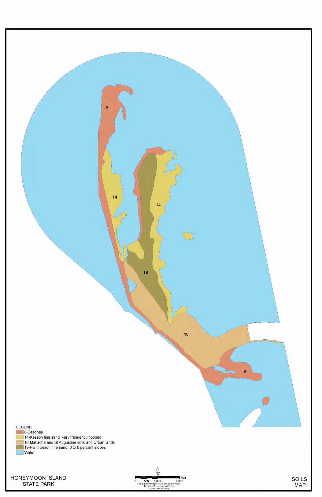
Soils
The natural portions of the island consist of undifferentiated sand, shell, clay, marl and peat -- mostly less than 4,500 years old. The dredged material added to the island is unconsolidated sand to a depth of 14 ft. This is underlain by limestone and coral to a depth of 20 ft, with chert below that. The fill is mainly fossiliferous limestone, with the remainder being black chert and residue from the abrasion of limestone during dredging. Most of the fill was boulder size or larger. There are four soil types (see Soil Map) on Honeymoon Island: coastal beaches, made land, St. Lucie fine sand with shell substratum, and tidal swamp (Vanatta et al. 1972). Addendum 3 contains a detailed description of the soil types in the unit. The soil conservation and soil erosion issues at this park arise where Made Land (Ma) occurs. Beach erosion and deposition is a natural and continuous process. However, where the beach has been subjected to dredge-and-fill operations, limestone pebbles and rocks are uncovered when the sand is washed away. These have unaesthetic qualities and are difficult to maneuver upon, forming a relatively hardened shoreline of limestone rock. A mechanical beach cleaner capable of removing rocks is periodically
14
used to remove small amounts of limestone rubble from the recreational beach.
Minerals
There are no known mineral resources at Honeymoon Island State Park.
Hydrology
There is no permanent surface water in the park. The park is not adversely affected by shoreline erosion, except where the beach consists of dredged fill. Nonetheless, beach erosion and deposition are natural processes, even where Made Land is concerned. Natural erosion and accretion will continue to cover and expose limestone pebbles and rocks.
Natural Communities
The system of classifying natural communities employed in this plan was developed by the Florida Natural Areas Inventory (FNAI). The premise of this system is that physical factors, such as climate, geology, soil, hydrology and fire frequency generally determine the species composition of an area, and that areas which are similar with respect to these factors will tend to have natural communities with similar species compositions. Obvious differences in species composition can occur, despite similar physical conditions. In other instances, physical factors are substantially different, yet the species compositions are quite similar. For example, coastal strand and scrub--two communities with similar species compositions--generally have quite different climatic environments, and these necessitate different management programs. Honeymoon Island State Park contains nine distinct natural communities in addition to ruderal and developed areas (see Natural Communities Map). Park specific assessments of the existing natural communities are provided in the narrative below. A list of plants and animals occurring in the unit is contained in Addendum 4. Beach dune. This dynamic community is essential for the protection of inland biological communities and serves as a reservoir of sand for the beach (marine unconsolidated substrate). Dune vegetation exhibits several morphological adaptations, allowing survival in the nutrient-poor, unstable, exposed environment. Nevertheless, plants are extremely vulnerable to foot traffic and vehicle trails. The latter damage the vegetation and begin a trend of beach dune erosion. On Honeymoon Island, this community type extends along the western shoreline, north of the intensive recreational use area demarcated by the bathhouses, almost to the end of a sandspit at the northern tip of the barrier island. There is also a narrow swath of remnant dune community running north and south through the center of the island. Man-made dune habitat near the bathhouses is protected within barriers that prevent trampling. Beach dune is characterized by the prevalence of species such as beach elder, sea oats, beach cordgrass, bitter panicum, seashore paspalum, beach dropseed, sea purslane, beach orach, ground cherry and sea rocket. Australian pine and Brazilian

16
pepper have been eradicated in most of this community Coastal strand. This community is a narrow, linear zone of vegetation on the northern half of the island, except on the sand spit. It occurs between the beach dune community and mesic flatwoods. Coastal strand is not well established on Honeymoon Island, and it is sometimes difficult to identify. It is characterized by some unique salt-tolerant shrubs. Typical species present include cabbage palm, seagrape, saltbush, Florida swampprivet, Hercules-club, prickly pear, and occasional slash pines, as well as a declining amount of Brazilian pepper. Along most of its length, this community grades rapidly into beach dune on the seaward slope and mesic flatwoods on the opposite slope. Maritime hammock. This community type occupies only a small area at the center of the island --- an old dune depression that has been stabilized long enough to allow growth of a forest. It is dominated by cabbage palms, and southern red cedar in the canopy, coin vine, necklace pod, saffron plum and sedges in the ground layer, and it is without oaks. The community grades into coastal strand and mesic flatwoods. Brazilian pepper has been removed from the understory. The soil is more organic and drains more slowly than adjacent coastal strand. Other species include wax myrtle and poison ivy. Although fire is rare in well-developed maritime hammocks, the small size of this community type, as well as the adjacent pyrogenic communities, cause fire to play a more important role in its appearance. Mesic flatwoods. Although this community harbors slash pine, it is not the typical open-canopy forest with little or no understory that occurs on the mainland. These flatwoods tend to have an understory of cabbage palms. Hercules’ club, Florida swampprivet, and wax myrtle (or Brazilian pepper if it is allowed to propagate), as well as saw palmetto, poison ivy, and occasional red cedar, are also present in the understory. There can be an extensive layer of pine litter. Mesic flatwoods occur in the center of the northern half of the island. The numerous slash pine snags and dead trees are home to a relatively large number of osprey nests. As for Brazilian pepper, progress continues to bring this species under control. Several small mosquito ditches traverse the community, as do several jeep and hiking trails. The reintroduction of fire has controlled the excessive fuel accumulation. Overall, the mesic flatwoods on Honeymoon Island remain relatively undisturbed. Marine grass bed. Grass beds are extensive along the eastern side of Honeymoon Island and other undeveloped, healthy Gulf coast barrier islands at this latitude. This community is supported where coastal waters are clear, shallow, sheltered from excessive wave-energy, and have a fine mud or sand substrate. Once established, grass beds reduce the wave energy on the bottom and promote sedimentation of suspended particles. Hence, marine grass beds tend to accumulate soil. Unfortunately, development around St. Joseph Sound has increased turbidity of the coastal waters due
17
to stormwater runoff and disturbance of sediments. Boat propellers and anchors have also damaged the marine grass beds. Established protection zones have prevented further mechanical damage, and promoted healing of the scars. The success of these measures is monitored by Pinellas County Environmental Services. The dominant species of seagrass are manatee grass, shoal grass, and turtle grass. This community grades into marine tidal marsh, marine tidal swamp and marine unconsolidated substrate. Marine mollusk reef. This reef community occurs in St. Joseph Sound in two places north of the park’s entrance station. It is composed of the oyster, Ostrea frons. The reef is intertidal, and is exposed at low tide. Mollusk reefs typically harbor other sessile and benthic invertebrates, which attach to and live within the collage of oyster shells. This community provides an important feeding ground for several species of wading birds. Marine tidal marsh. This community occurs in close association with Marine tidal swamp on the more stable portions of the barrier island, and occurs on the landward side of the sandspit extending from the northern half of the island. It generally requires low energy coastline with a gentle slope to develop. It is characterized by expanses of grasses, including smooth cordgrass, saltmeadow cord grass, seashore paspalum and seashore saltgrass. Salicornia, saltwort and sea blight are also present. The park is at the latitude where the mangrove-dominated intertidal zone begins to be replaced by non-woody marsh vegetation (Montague and Wiegert 1990). Both are interspersed at Honeymoon Island. Marine tidal swamp. This community, dominated by mangrove trees, occurs mainly along the relatively flat, low wave energy eastern shoreline of Honeymoon Island. It intergrades with marine tidal marsh. Although black mangrove is prevalent, red mangrove and white mangrove are also present, as is buttonwood. Glasswort and saltwort are sometimes present in the ground layer. A low berm of sediment and decaying vegetation builds up along the water’s edge of this community. Mosquito canals have been dug through this community, and the associated spoil piles have provided a foothold for the invasion of Brazilian pepper. Marine unconsolidated substrate. The acreage of this very dynamic community fluctuates from year to year. It is characterized as a sparsely vegetated or unvegetated, open area of subtidal, intertidal and supratidal coastline. On the Gulf side of the island, the unconsolidated substrate is beach sand, while on the bay side it is mudflat. This community includes infaunal organisms vulnerable to disturbances such as dredging, and to low levels of dissolved oxygen. It includes the intertidal beach habitat below the Beach Dune community. Although this is a zone of sparse vegetation, it is a rich feeding zone for wading birds and shorebirds, which are able to probe below the surface for infaunal organisms such as isopods, amphipods, polychaetes, mollusks and crustaceans. Subtidal, intertidal and supertidal zones are each associated with a
18
characteristic suite of organisms. The feeding grounds at Honeymoon Island help support the very significant nesting shorebird colony on Three Rooker Island, to the north. The southern beach at Honeymoon Island, next to Hurricane Pass, has been designated a “pet beach,” and is a place for pet owners to enjoy beach recreation with their animals. Pets, excluding exotic and barnyard animals are required to be on a leash. This specially designated section of beach has proven to be quite popular. Some of the park’s marine unconsolidated substrate community has been altered by dredging, particularly along the southwestern-facing shoreline on the southern portion of the island. This disturbance is manifested by limestone rock rubble littering the beach, especially after storms. Where the rubble is present, the beach is difficult to walk on, and the area is avoided by humans, sea turtles and most shorebirds. The community grades into beach dune, marine tidal marsh or marine tidal swamp. Ruderal. Ruderal communities are characterized by overwhelming human alteration of the natural substrate or biological community. These communities require long-term restoration efforts. Native vegetation is sparse, and pioneering species may be prevalent. It is mostly free of exotics. Most of the ruderal habitat occurs on the southern half of Honeymoon Island. It originated from dredge-and-fill operations of an aborted development project. As a credit to park management, some of the ruderal area has been restored--for example, the coastal strand community that occurs to the south and southeast of the entrance station, and east of bathhouse # 1. Progress establishing a coastal strand community with a few components of the mesic flatwoods has been undertaken. A low grass cover, punctuated by occasional shrubs characterizes the ruderal community. Hairgrass is present, as is common ragweed, rough hairy indigo, white sweet clover, red natalgrass and saltbush, along with several other pioneer and exotic species. This community has low diversity; however, it is slowly beginning to improve by planting appropriate native plants. Developed. These are sites where the natural biological communities have been replaced or nearly replaced by structures, roads, visitor facilities, campgrounds, parking lots, concessions or permanently cleared areas. The park continues to serve a large recreational user group interested in beach-oriented activities. There is also a parking lot and land base with dock for visitors using Caladesi Island State Park. Ferryboats transport park visitors back and forth. Other developed areas include park residences, a shop area and a staging area with conference rooms converted from a mobile home.
Designated Species
Designated species are those that are listed by the Florida Natural Areas Inventory

19
(FNAI), U.S. Fish and Wildlife Service (USFWS), Florida Fish and Wildlife Conservation Commission (FFWCC), and the Florida Department of Agriculture and Consumer Services (FDA) as endangered, threatened or of special concern. Addendum 5 contains a list of the designated species and their designated status for this park. Management measures will be addressed later in this plan. Honeymoon Island is a very significant feeding and wintering site for shorebirds. It is ranked second among 27 sites in biological importance to wintering shorebirds on the Southwest coast and is ranked third in the State (Sprandel et al. 1997). It is located due south and in close proximity to Three Rooker Island, which is consistently ranked among the top five shorebird nesting sites in the State by biologists of the Florida Fish and Wildlife Conservation Commission. A large number of piping plovers, a state- and federally-listed threatened species, forage and rest at Honeymoon Island. The island also supports several species of nesting shorebirds, including the Wilson’s plover and two threatened species, the least tern and the snowy plover, as well as a species of special concern, the American oystercatcher. In addition to the four listed species of shorebirds noted above, 34 other designated bird species have been documented in the park. Six designated reptile species, and one designated mammal species have been documented. As for plants, -four designated species have been discovered in the park. The park is noted for its large number of osprey nests. The hiking trail, which traverses the northern half of the island, passes in close proximity to several of the nests, without apparent harm. Atlantic loggerhead sea turtles nest on the beach. Raccoons, which are responsible for most sea turtle nest depredation on barrier islands, are also present on Honeymoon Island. West Indian manatees, utilizing the Anclote River and the warm water refuge provided by the springs in Whitecomb Bayou, also use seagrass beds in the Park (J. Archer, pers. comm.). Manatees have been seen in the shallow seagrass beds north of the managers’ residences.
Special Natural Features
Honeymoon Island State Park does not possess any natural features that are unique to the island. In 1993, only the northern portion of the island remained in natural condition (Johnson and Muller 1993). Since that time, sites on the southern half of the island continue to be restored to a more natural condition. As mentioned above, the park’s proximity to Three Rooker Island, where shorebird nesting is of statewide significance, makes it important as a shorebird use area. The large number of osprey nests in the park is also notable, as is the large number and diversity of migrant bird species observed on the island.

20
The park has extensive seagrass beds within its eastern boundary. This community type is one of the most important of all coastal systems when the numbers of animals and plants that utilize it directly and indirectly for food, shelter and/or substrate are considered (Zieman and Zieman 1989). Seagrass beds act to stabilize sediments, function as nurseries for vertebrate and invertebrate species, provide high net primary productivity and function directly and indirectly in the food chain of many marine species, including herbivores, omnivores and detritivores (Bard 1992)
Cultural Resources
Evaluating the condition of cultural resources is accomplished using a three part evaluative scale, expressed as good, fair, poor. These terms describe the present state of affairs, rather than comparing what exists against the ideal, a newly constructed component. Good describes a condition of structural stability and physical wholeness, where no obvious deterioration other than normal occurs. Fair describes a condition in which there is a discernible decline in condition between inspections, and the wholeness or physical integrity is and continues to be threatened by factors other than normal wear. A fair judgment is cause for concern. Poor describe an unstable condition where there is palpable, accelerating decline, and physical integrity is being compromised quickly. A resource in poor condition suffers obvious declines in physical integrity from year to year. A poor condition suggests immediate action to reestablish physical stability. The first inhabitants of Honeymoon Island are believed to have been the local Safety Harbor culture, namely the Tocobagos, but this has not been confirmed. Hog Island Mound (8Pi9) on Caladesi contained skeletal remains, but from which culture is not known (Moore 1903). Pieces of pottery and chainmail dating to the sixteenth century reportedly have been found on Honeymoon Island. These indicate that Europeans used the island for at least a stopping-off point. Maps dating to the 1830s referred to the barrier island as Sand Island. Between 1830 and 1939, the island was given the name Hog Island. In 1921, because of a hurricane, Hog Island was breached into two islands. The Florida Master Site File lists a site (Pi747), named the “Osprey Breeding Site,” which is on Honeymoon Island proper. It is an artifact and lithic scatter site. The site was discovered in 1982, and was mapped as a large area encompassing the center of the northern half of the island. A dirt road apparently runs through the site. A possible second site is an anomalous sand mound located adjacent to the Osprey Trail. Shell is observable on the surface in conjunction with animal burrows. Aerial maps from the development era of the 1970’s reveal that much of the area was bisected east-west by ditches or canals; a short time later aerial maps show the canals filled and spoil piles visible. Remaining artifacts would have been very disturbed and out of context.
21
Honeymoon Island was named in 1939, by New York developer that built cottages and promoted the island as a vacation site. In the area of the interpretive trailer, there is a concrete pad and two upright, freestanding elements approximately five feet high. Photographs from the era of the Honeymoon cottages, about 1939-1940, indicate that this structure could have been part of the resort complex.
RESOURCE MANAGEMENT PROGRAM
Special Management Considerations
Timber Management Analysis
Chapters 253 and 259, Florida Statutes, require an assessment of the feasibility of managing timber in land management plans for parcels greater than 1,000 acres if the lead agency determines that timber management is not in conflict with the primary management objectives of the land. The feasibility of harvesting timber at this park during the period covered by this plan was considered in context of the Division’s statutory responsibilities, and an analysis of the park’s resource needs and values. The long-term management goal for forest communities in the state park system is to maintain or re-establish old-growth characteristics to the degree practicable, with the exception of early successional communities such as sand pine scrub and coastal strand. A timber management analysis was conducted for this park. During the development of this plan, it was determined that because the park is a barrier island, timber management activities would not be feasible and that the primary management objectives could be adequately met without conducting timber management activities.
Additional Considerations
The ospreys nesting at Honeymoon Island State Park are given special consideration in management plans for the mesic flatwoods where they occur. Management activities in burn zones where there are nests are curtailed while the breeding season is in progress and/or nests are active. There are extensive seagrass beds in the shallow waters along the eastern side of Honeymoon Island, and behind the sandspit extending from the northern end of the island. Between 1950 and 1982, as much as 72 percent of the historic seagrass cover was lost in St. Joseph Sound east of Honeymoon Island (Bard 1992). Between 1973 and 1990, approximately 20 percent of seagrass cover was lost from the nearshore waters around Honeymoon and Caladesi islands. Turtle grass (Thalassia testudinum), manatee grass (Syringodium filiforme) and shoal grass (Halodule wrightii) are all present in a mixed-species seagrass community, which suffered a dramatic increase in the number of propeller scars between 1979 and 1990 (Bard 1992, FMRI 1993). The seagrass beds are now part of the Pinellas County Aquatic Preserve. Since November 1994, most of the seagrass beds along the eastern side of Honeymoon Island have been protected within a combustion engine exclusion zone. Some beds off the north end of the island, and
22
behind the most northern portion of the sandspit are not within the zone. These should be monitored for damage, and seagrass beds at a depth that places them in danger of being damaged should be included in protected areas such as combustion engine exclusion zones. With minimal damage to rhizomes, plant recovery may occur within a year. Where damage is severe, recovery may take 10 years or more. Monitoring of seagrass bed recovery has been implemented. Monitoring should be continued in cooperation with Pinellas County Environmental Services. Another special management consideration is shorebird nesting on the island. During the breeding season, nesting sites should be protected from trespass by visitors, and high densities of terrestrial predators should be controlled. Biologists from the Florida Fish and Wildlife Conservation Commission will provide assistance with this special management activity. Finally, the influence of visitors on marine turtle nesting also requires special management consideration, especially since humans and turtles may be trying to use the beach at the same time. As with other management issues discussed above, education is a key management tool to avoiding conflicts between visitors and designated species. In 2006, over 400 After Hours Use Permits were issued which is nearly twice the number since 2003. Visitors may fish in designated areas, and walk or cycle on paved roads. Results using Pinellas county traffic counting devices in 2005 and 2006 revealed no extraordinary use patterns. Cursory checks of nocturnal visitor use disclose no resource conflicts; however, this will be assessed in more depth. If problems become evident, nocturnal recreational use may be restricted along the beach in control sites to evaluate the impact of nighttime recreational use on wildlife. Fishermen will need to be very sensitive to the possibility of disturbing sea turtles coming ashore to nest. If necessary, preferred nesting sites along the beach can be protected from trespass, just as for shorebird nesting.
Management Needs and Problems
The principal management problem at Honeymoon Island State Park is the threat to the natural biota from invasive exotic plants, especially Australian pines and Brazilian peppers. Australian pines readily colonize accreting beach dune habitat, and where these trees are present in a line along the foredune, they can obstruct turtle nesting. Before exotic plant removal began, Brazilian pepper had become especially prevalent in the mesic flatwoods and coastal strand communities on Honeymoon Island, where it crowded out native species in some locations. The dense tangle of branches of this exotic species can displace native vegetation. Although there are still some locations where pepper trees dominate the vegetation, great progress has been made in recent years in reducing the acreage of this exotic. Australian pines are virtually absent from the park. Monitoring and maintenance-removal of young saplings by hand will keep this problem species under control.

23
A more recent exotic invasive problem is the spread of cogon grass from into natural communities. Ongoing eradication is underway. The invasive, exotic carrotwood has been found in a few locations. Where the tree is found, it will be removed to avoid further dispersal. The second management need at Honeymoon Island State Park is protection of shorebird resting and nesting sites. The park is a heavily used recreation area. Resting and nesting shorebirds suffer constant disturbance during periods of high recreational use if barriers are not in place to prevent ingress. The use of signs and flagging has proven effective against disturbance, when combined with education and enforcement of regulations when it becomes necessary. Monitoring for shorebird nesting is conducted each season, and protective measures will continue to be implemented at nesting sites. Monitoring should continue, to verify that protection from disturbance has been achieved. As noted previously, Honeymoon Island ranks among the top sites as a wintering location for shorebirds. Resting sites used by wintering shorebirds should be regularly monitored for disturbance, protective measures implemented, and their success evaluated. Continued planting of native vegetation in ruderal areas, as well as maintenance of natural communities, which are still functioning or restored, is the third management need. The successful program of prescribed burning in fire-adapted communities will continue. In addition, reintroduction of native vegetation in those areas still designated ruderal should continue. The problem of ruderal beachfront habitat is a vexing one. Limestone pebbles and rocks resulting from historical dredge-and-fill operations continue to be exposed on the recreational beach at the park. Beach building by depositing many tons of sand has proven to be a temporary, and expensive, fix. A machine especially designed to clean rocks from the recreational beach works in a limited capacity, as long as the accumulation of rocks is not too great. In spite of all this, rocks continue to thwart the enjoyment of beach-goers at the park, as well as interfere with the foraging of shorebirds that prefer typical beach habitat. A beach renourishment project is anticipated in the future in the area near the cafe to the northern lagoon, using sand from an offshore bar. The duration of the sand placed on the rocky beach is estimated to be several years. A fourth management problem is protection of the seagrass beds around Honeymoon Island. The seagrass protection zone around Honeymoon Island was authorized in 1994. A total of 21 “Combustion Motor Exclusion” signs were installed along the marine grass bed community at the three -foot, mean high tide, depth contour (Smith 1998). The aging signs were replaced in 2006 with funding from Pinellas County. At this time, if other areas need protection, signs will be placed appropriately. The need now is for continued monitoring of the beds as they recover from scarring and turbidity. The signage appears to be an effective method for compliance. The welfare of resident or transient manatees and other marine animals, as well as those using park waters as a
24
travel corridor is fostered by a healthy benthic community. The fifth management need is to continue to monitor the activities of several listed species that utilize natural communities on the island. Specifically, osprey nesting and wading bird nesting and resting sites should continue to be monitored, and the success of protective measures evaluated. Similarly, nesting sea turtles should continue to be monitored. The final resource management need is to assess the magnitude of the disturbance caused by the intensive nocturnal recreational use at the park. During peak sea turtle nesting season, which coincides with snook fishing season, after-hours usage in the park increases through the usage of permits. The numbers of visitors will be monitored and appropriate measures taken if damages to the resources are occurring. In 2003, there were 20 false crawls, and only 14 Atlantic loggerhead nests at the park. This is a higher ratio of false crawls than at other barrier island parks. It appears that in this season, the primary reason for the high number of false crawls was from raccoons approaching the turtle as she began to dig the nest. A few of the crawls in the rocky areas were aborted. The impact of nocturnal recreational use on shorebirds also needs to be assessed. Finally, diurnal, as well as nocturnal, shell collectors need to be sensitive to negative impacts that may result from collecting live mollusks. A comprehensive inventory of cultural resources is needed, specifically a Level I archaeological survey. Concurrently, protection from vandalism and other forms of encroachment is needed, along with interpretation of the sites to park visitors.
Management Objectives
The resources administered by the Division are divided into two principal categories: natural resources and cultural resources. The Division primary objective in natural resource management is to maintain and restore, to the extent possible, to the conditions that existed before the ecological disruptions caused by man. The objective for managing cultural resources is to protect these resources from human-related and natural threats. This will arrest deterioration and help preserve the cultural resources for future generations to enjoy. The first management objective at Honeymoon Island State Park is to prevent the spread of invasive Australian pines and Brazilian peppers to such an extent within the next five years that one park ranger assigned to an area, such as a burn zone, could maintain control of exotics in that zone thereafter. The problem of invasive, exotic plants has been addressed energetically at the park in recent years. With the help of programs like AmeriCorps, Florida State Parks, and with the assistance of volunteers, park personnel have been able to clear many acres of exotic vegetation. Additional funding will apparently be available in coming years to continue this work. Undoubtedly, new exotic species problems will arise. Recently St. Augustine grass was
25
recognized as an invasive plant that also needs to be controlled. Nonetheless, it is very gratifying that invasive, exotic plants are very nearly eliminated from in the park. Sea turtles are threatened and need to be protected from disturbances that may interfere with reproduction. Protecting sea turtle nests, like shorebird nests, may require control of terrestrial predators, as well as protection from human disturbance. The potential for the latter is especially great at Honeymoon Island State Park because of the after-hours permits that are issued. An objective of this plan is to assess the impact of nocturnal recreational use on sea turtle nesting activity. An associated objective is to assess the impact on shorebirds. Accomplishment of these objectives may necessitate restrictions on nocturnal recreational use, in order to provide a beach control site. The protocol for monitoring sea turtle nests is well established, and has been followed at the park. Another important objective is adequate protection of shorebird nesting and wintering sites from human disturbance. Disturbance can be severe on sandbar spits, which are preferred by both shorebirds and visiting boaters. Shorebirds prefer these sites because they have fewer terrestrial predators, and they are located near highly productive foraging habitat like mudflats. Visitors enjoy them because they offer some of the best Gulf beach recreation sites accessible to boats, and because of their obvious aesthetic qualities. A new sport which is fast-growing is kite boarding or kite sailing. A large parasail propels the participant on a board. The sails are large and create a large moving shadow. Birds have been observed repeatedly scattering into the air when the boards pass near. Monitoring the disturbance should be conducted and exclusion areas should be considered. The objective of shorebird protection should be sufficient separation of visitors from colonies of nesting shorebirds to preclude birds from expending energy on human disturbances. The objective for wintering shorebirds, which can expend as much as 10 percent of their body weight in one weekend responding to disturbance by visitors (Below 1997), should be protected “sanctuaries” on the beach where they can rest without disturbance. Weight loss due to disturbance is especially critical at a time when birds are replenishing their fat reserves for migration and the next nesting season. Protected areas have been established and signs with the designation “Environmentally Sensitive Area” are being placed in appropriate areas. Protection must also address the problem of disturbance caused by pets and terrestrial predators. For the former, a pet beach is available. For the latter, protection may require removal of terrestrial predators where they occur at a high density. An objective for maintaining natural communities is to continue the successful burn program in progress. In addition, some ruderal areas are being planted with native vegetation with the objective of making them more characteristic of the historical
26
natural community type. The remaining objectives involve protecting and monitoring seagrass beds, osprey nesting and wading bird colonies. The objective for monitoring osprey nests and wading bird resting/nesting colonies is to identify any impact from anthropogenic sources, as well as to collect information on the variability of annual reproductive success. Recovery of seagrass beds within the protection zone needs to be monitored and documented. Any additional seagrass community that requires protection should be identified. Enforcement of the boating exclusion zone, violation of which is considered a misdemeanor, should also continue.
Management Measures for Natural Resources
Hydrology
There is no permanent surface water at Honeymoon Island State Park. Several storm water ponds were created next to parking lots when the latter were enlarged and paved. Dense cattail stands have grown in some ponds and may impair the functioning of the ponds. A plan for removal should be made. These should not require any management. Boardwalks and other walkways have controlled erosion from foot traffic through the beach dune community. Another, more difficult problem occurs at the intertidal line along some of the beach (Marine unconsolidated substrate) because of manmade disturbances. The natural, dynamic movement of sandbars and spits reflects the forces of natural phenomena, and does not constitute adverse impacts implied by the concept of soil erosion. However, along the developed beachfront at Honeymoon Island, erosion of sand exposes limestone fill that dates from an earlier development attempt. The hard limestone curtails beach recreation. Attempts to maintain a sand substrate have thus far not been successful. This is a difficult problem not easy to solve. In the past, ditches were dug for mosquito control in the mangrove and mesic flatwoods communities along the eastern side of the Island. Most of these have filled in to some extend, and interested parties have agreed that the ditches will not be maintained. At the present, further restorative action would probably cause more damage than benefit.
Prescribed Burning
The objectives of prescribed burning are to create those conditions that are most natural for a particular community, and to maintain ecological diversity within the unit's natural communities. To meet these objectives, the park is partitioned into burn zones, and burn prescriptions are implemented for each zone. The park burn plan is updated annually to meet current conditions. All prescribed burns are conducted with authorization from the Department of Agriculture and Consumer Services, Division of Forestry (DOF). Wildfire suppression activities will be coordinated between the Division and the DOF.

28
Honeymoon Island has been divided into 11 small burn zones ranging in size from 2 to 16 acres (see Burn Zone Map). These comprise the mesic flatwoods community. Living and dead slash pines are present, as is saw palmetto. Osprey nests present a special concern for prescribed burning at the park. Precautions are taken to avoid burning nest trees, and burning is usually not conducted during nesting season, which can extend from February through June. Burn zones are demarcated by roads, trails and ecotones. The extent of mesic flatwoods on barrier islands prior to settlement is unknown (see Herwitz 1977). However, given the extent of this community type on Honeymoon Island now, lightning-ignited fires would probably occur periodically. Thus, a benefit of regular prescribed burning is a lower, safer level of fuel loading. Smoke dispersal is an important consideration, and care must be taken to avoid smoke dispersal towards the condominium complex on the southern part of the island. On the northern half of the island, extensive stands of Brazilian pepper have been removed in burn zones 3 and 5, and smaller infestations have been treated in zones 4, 6 and 9. Zone 10 still requires extensive treatment. Nevertheless, these zones are at a stage where they can be burned at 3- year intervals or less, as is typical for inland mesic flatwoods communities. The season of burn for a particular zone will depend on osprey nesting activity within it, but growing season burns are preferred.
Designated Species Protection
The welfare of designated species is an important concern of the Division. In many cases, these species will benefit most from proper management of their natural communities. At times, however, additional management measures are needed because of the poor condition of some communities, or because of unusual circumstances that aggravate the particular problems of a species. The Division will consult and coordinate with appropriate federal, state and local agencies for management of designated species. With regard to designated plant species found at Honeymoon Island, populations of the butterfly orchid should be surveyed. The only population recently observed is in an area difficult to reach and thus protected at this time. Other species requiring special protection are beach dune species that will be well served by dune preservation. Boardwalks or “soft “corridors using post and rope that prevent trampling of beach dune vegetation and prevent erosion will greatly benefit these species. No other special measures to protect designated plants are required at this time. As stated above, several designated animal species require special protection measures. These include the sea turtles and shorebirds, as well as ospreys. Sea turtle nesting on Honeymoon Island has been monitored routinely in the past by park personnel. Atlantic loggerheads construct between three and 30 nests on the island in any given

29
year. There were 14 nests in 2003, of which seven produced hatchlings. However, nests do require protection from human disturbance, as well as from unusually high populations of terrestrial predators, such as raccoons attracted to picnic areas. Sea turtles are particularly prone to disturbance during nocturnal nesting activities at Honeymoon Island because of the visitors using the park after hours. As a first step, a control site, where nocturnal recreational use is restricted, could be established to assess the level of impact. Additional management actions may be needed if nesting turtles are being disturbed by visitors. Preferred nesting sites along the beach could be protected from trespass by using temporary barriers, just as for shorebird nesting. Eventually, sufficient data may be available to establish a quantitative relationship between the number of after-hours permits issued and the ratio of false crawls to nests. When this level of sophistication is reached, a carrying capacity may be promulgated for after-hours recreation, which will determine the number of after-hours permits issued. With regard to raccoons, wire screens have proven effective in protecting nests. Monitoring of osprey nests at Honeymoon Island should continue as in the past to verify that management at the sites is adequate. Most of the remaining designated species are wading birds and shorebirds. Least terns and snowy plovers nested on Honeymoon Island in 2003. American oystercatchers have also nested in the past. Many additional designated species use the beach, dunes and mud flats for resting and foraging, including some shorebirds that spend the winter here. In order to protect these designated species special protection measures are required. Nesting must be monitored in order to locate and secure preferred nesting areas from disturbance. Nesting habitat should be posted and barriers should be in place no later than April 15. Signs, posts and barriers should be maintained throughout the season. Nesting sites need to be patrolled as necessary to protect them. Volunteers can assist park staff in providing an effective protection program. Education and interpretation are important in gaining cooperation from visitors. Regular patrols and enforcement of the law will be necessary to elicit cooperation from a few. No pets should be allowed on or near the beach outside the designated pet beach. Exercising a pet near shorebirds is a recreational use that can be detrimental, unfortunately, to the natural resource. Recent studies of the effects of human activity on breeding bird colonies in Florida have quantified setback distances for different species. Human approach closer than these distances is ill advised and should be prohibited because it forces birds to expend energy required for successful reproduction. A similar situation exists for wintering shorebirds. In the latter case, human disturbance causes expenditure of critical energy reserves required for migration, or the next nesting season (Helmers 1992). Minimum setback distance from nesting shorebirds is 590 feet (180 m) (Rodgers and Smith 1995). Ideally, this should be the distance from signs and barriers to the outermost nests and
30
individuals in the colony. Wintering shorebird sites should be posted similarly. An interpretive display may be included where the barrier is implemented. The Regional Nongame Biologist of the Florida Fish and Wildlife Conservation Commission, Lakeland, Florida, is available to provide assistance with the implementation of protective measures (Douglass, pers. comm.). There are no known wading birds nesting colonies at Honeymoon Island now. However, designated wading bird species utilize various habitats in the park for foraging and roosting. Prohibition of pets outside the pet beach will also benefit these species. The idle speed zone in the boat dock basin is beneficial to the West Indian manatee, which often is the victim of collisions with boats and cuts from propellers. The combustion engine exclusion zone established to protect seagrass beds will also benefit the manatee. Educational materials, such as manatee information signs, brochures, posters, boater guides and decals should be distributed and interpreted to visitors. The FWCC Bureau of Protected Species Management can assist with acquiring educational materials, staff training, and manatee sighting forms. The latter are an important monitoring tool. With the intensity of recreational use, a special effort is needed to control litter harmful to designated species and other wildlife. Much of the litter, such as monofilament line and terminal tackle, is associated with fishing activities. Therefore, education and adequate disposal receptacles are essential.
Exotic Species Control
Exotic species are those plants or animals that are not native to Florida, but were introduced because of human-related activities. Exotics have fewer natural enemies and may have a higher survival rate than do native species, as well. They may also harbor diseases or parasites that significantly affect non-resistant native species. Consequently, it is the strategy of the Division to remove exotic species from native natural communities. There are no known exotic species of concern at this time. Great progress has been made in the removal of exotic, invasive plants at Honeymoon Island in recent years. Much of this work was done in 1996, beginning with contract labor funded and supported through park grant efforts. The work was subsequently continued through 1997 and into 1998, by industrious employees of the AmeriCorps Florida State Parks program. The grant-funded work was ultimately completed by park staff in March 1998. Several dense stands of Brazilian pepper still occur on the northern half of Honeymoon Island. Its occurrence on the southern half of the island is more sporadic, where it is found interspersed with mangroves lining drainage canals, and in the ecotone between mangroves and mesic flatwoods. The schedule for eradication of
31
large stands of Brazilian pepper is being conducted on a burn zone basis. Several heavily infested zones at the north end of the island have been cleared, and operations are continuing southward. The goal is to eradicate Brazilian pepper to a maintenance level within five years, and begin a program of monitoring and removal, with an individual park ranger responsible for the zones. The control of Australian pines is in a maintenance phase. Saplings occur sporadically in the beach dune and coastal strand communities. These can be easily pulled by hand. Two other exotic plant species requiring intensive control efforts are cogongrass and St. Augustine grass. Several small patches of the former have been treated, and the latter was recently noted to be invading natural communities. Immediate control of these two species is desired. Treatment programs for infested sites have extended over a two-year period to reach this goal. The exotic animals documented on Honeymoon Island do not require eradication programs. Exotic removal will proceed as outlined in the previous section. Brazilian pepper will be eradicated from individual burn zones in a sequential manner. After that, park staff can be assigned to zones to monitor for and remove recurrences of the plant. Australian pines can be controlled by hand pulling as they are found. The two exotic grass species, cogongrass and St. Augustine, will be treated with the appropriate herbicide wherever they occur, and will be re-treated or mechanically treated in accordance with the protocol for eradication. The infestations now present should be eradicated within two years. Assistance from organizations like AmeriCorps Florida State Parks and from volunteers will help keep the exotic removal program on schedule. Contracting some of the work has been a successful option.
Problem Species
Problem species are defined as native species whose habits create specific management problems or concerns. Occasionally, problem species are also a designated species, such as alligators. The Division will consult and coordinate with appropriate federal, state and local agencies for management of designated species that are considered a threat or problem. Raccoons are a problem species when they interfere significantly with sea turtle nesting and/or shorebird nesting at Honeymoon Island State Park. Numbers are reduced in accord with agency policy.
Management Measures for Cultural Resources
The management of cultural resources is often complicated because these resources are irreplaceable and extremely vulnerable to disturbances. The advice of historical and archaeological experts is required in this effort. Approval from Department of State, Division of Historical Resources (DHR) must be obtained before taking any actions, such as development or site improvements that could affect or disturb the cultural
32
resources on state lands (see Additional Information). Actions that require permits or approval from DHR include development, site excavations or surveys, disturbances of sites or structures, disturbances of the substrate, and any other actions that may affect the integrity of the cultural resources. These actions could damage evidence that would someday be useful to researchers attempting to interpret the past. The park has not been subjected to a systematic cultural resource assessment survey. Because of the known archaeological resources in the vicinity, management measures for cultural resources at Honeymoon Island include drafting a proposal for a Level I archaeological survey. Ground disturbing activities should be conducted in accordance with Division policy.
Research Needs
Natural Resources
Any research or other activity that involves the collection of plant or animal species on park property requires a collecting permit from the Department of Environmental Protection. Additional permits from the Florida Fish and Wildlife Conservation Commission, the Department of Agriculture and Consumer Services, or the U.S. Fish and Wildlife Service may also be required. An extensive inventory of the avian species of Honeymoon Island is available, due in large part to records kept by local Audubon Society members. A thorough inventory of other animal, as well as plant, species is needed. The park has a combination of temperate and tropical plants, which may change with climatic trends. In general, baseline inventories are utilized to measure the effect of management actions. On Honeymoon Island, this includes measuring the success of exotic removal, and recolonization by native species. Research should be conducted on the effects of after-hours use on natural resources. Specifically, any impacts that nighttime recreational use on the beach may have on shorebird and sea turtle nesting should be assessed. This may entail establishing a control site on the beach where nocturnal recreational use is restricted during nesting season.
Cultural Resources
The primary research need at Honeymoon Island is a Level I archaeological survey.
Resource Management Schedule
A priority schedule for conducting all management activities that is based on the purposes for which these lands were acquired, and to enhance the resource values, is contained in Addendum 6. Cost estimates for conducting priority management
33
activities are based on the most cost effective methods and recommendations currently available.
Land Management Review
Section 259.036, Florida Statutes, established land management review teams to determine whether conservation, preservation, and recreation lands titled in the name of the Board of Trustees of the Internal Improvement Trust Fund (board) are being managed for the purposes for which they were acquired and in accordance with a land management plan adopted pursuant to s. 259.032, the board of trustees, acting through the Department of Environmental Protection (department). The managing agency shall consider the findings and recommendations of the land management review team in finalizing the required update of its management plan. Honeymoon Island State Park was subject to a land management review on November 6, 2003 (see Additional Information). The review team made the following determinations:
1. The land is being managed for the purpose for which it was acquired.
2. The actual management practices, including public access, complied with the management plan for this site.

34
35
LAND USE COMPONENT
INTRODUCTION
Land use planning and park development decisions for the state park system are based on the dual responsibilities of the Division of Recreation and Parks. These responsibilities are to preserve representative examples of original natural Florida and its cultural resources, and to provide outdoor recreation opportunities for Florida's citizens and visitors. The general planning and design process begins with an analysis of the natural and cultural resources of the unit, and then proceeds through the creation of a conceptual land use plan that culminates in the actual design and construction of park facilities. Input to the plan is provided by experts in environmental sciences, cultural resources, park operation and management, through public workshops, and environmental groups. With this approach, the Division’s objective is to provide quality development for resource-based recreation throughout the state with a high level of sensitivity to the natural and cultural resources at each park. This component of the unit plan includes a brief inventory of the external conditions and the recreational potential of the unit. Existing uses, facilities, special conditions on use, and specific areas within the park that will be given special protection, are identified. The land use component then summarizes the current conceptual land use plan for the park, identifying the existing or proposed activities suited to the resource base of the park. Any new facilities needed to support the proposed activities are described and located in general terms.
EXTERNAL CONDITIONS
An assessment of the conditions that exist beyond the boundaries of the unit can identify any special development problems or opportunities that exist because of the unit's unique setting or environment. This also provides an opportunity to deal systematically with various planning issues such as location, regional demographics, adjacent land uses and park interaction with other facilities. Honeymoon Island State Park is located within Pinellas County, about four miles northwest of downtown Dunedin within the Greater Tampa Bay Area. This area is one of Florida’s most populous regions, and it continues to see growth. The populations of Pinellas County and the adjacent Hillsborough and Pasco Counties have grown 24 percent since 1990, and are projected to grow an additional 24 percent by 2020 (BEBR, University of Florida, 2005). The median ages of Pinellas and Pasco Counties are 44.2 and 44.9 which indicates a significantly older community than the state average of 39.6 while Hillsborough County is significantly younger at 35.5 (BEBR, University of Florida, 2005). Nearly 2.7 million people reside within 50 miles of the park, which includes the cities of Brooksville,
36
New Port Richey, Tarpon Springs, Dunedin, Tampa, Brandon, Zephyrhills, Plant City, Lakeland, Clearwater, St. Petersburg, Bradenton and Sarasota (Census, 2000). Honeymoon Island State Park recorded 953,824 visitors in fiscal year 2005/2006, making it the second most visited unit in the state park system. By DRP estimates, these visitors contributed $39.4 million in direct economic impact and the equivalent of 788 jobs to the local economy, which ranks second among all the state park units (Florida Department of Environmental Protection, 2006). This impressive economic impact is due to the park’s location and level of development, leading to high attendance and park expenditure levels.
Existing Use of Adjacent Lands
The original shoreline of Honeymoon Island was bulkheaded along the bay side, and filled both east and west from the original shorelines for development in the 1960s, creating a manmade landform over the southern one-third of the island. That ruderal landscape has been the development location for beach recreation and picnicking facilities constructed by the Division. The Royal Stewart Arms Condominium (RSA) complex is a privately owned high-density residential development located at the extreme southeastern end of the island. The island is connected to the mainland by Dunedin Causeway. The primary effects of adjacent land uses on the park derive from the heavy, and essentially unregulated, recreational uses of the surrounding waters for boating, fishing, jet skiing, canoeing and kayaking. Future increases in the recreational boating population should be expected. The anticipated future impacts from increased demand for recreation include traffic congestion and conflicts at the park entrance road, continued crowding and safety problems in the surrounding waterways, and the potential disturbances to wildlife along the park’s shorelines. Adjacent development may facilitate the invasion of exotic plant species, and complicates the tasks of smoke management during prescribed fire operations in the park. There are numerous resource-based recreation opportunities near Honeymoon Island State Park. Two state parks are located nearby and are managed by the staff of Honeymoon Island. Just across Hurricane Pass to the south is Caladesi Island State Park that is only accessible by private boat or ferry service. This park offers beach activities such as swimming and sunbathing, picnicking, fishing, boating, a kayaking trail, wildlife viewing, birding, and hiking trails. To the north of Honeymoon Island is Anclote Key Preserve State Park. Visitors are welcome to swim, picnic, fish, view wildlife, and primitive camp. This park is only accessible by private watercraft. Pinellas County maintains 23 county parks comprising more than 4,000 acres. These
37
parks are situated in a variety of natural settings and collectively offer opportunities for beach activities, swimming, fishing, boating, canoe/kayaking, wildlife observation, picnicking, hiking, biking, horseback riding and camping. The Pinellas Trail is a linear park and recreation trail extending from St. Petersburg to Tarpon Springs along an abandoned railroad corridor. The Honeymoon Island Spur Trail, a 2.5-mile section of the Pinellas Trail that crosses the Dunedin Causeway, connects the State Park to the mainland. The causeway, itself, is also a popular recreation area for swimming, sunbathing, fishing, kayaking, and sailing.
Planned Use of Adjacent Lands
The Future Land Use Map for the City of Dunedin (1997) designates Honeymoon Island State Park, neighboring Caladesi Island State Park, and the Dunedin Causeway as “Recreation/Open Space.” The purpose of this designation is to retain open space and environmentally sensitive areas. The RSA complex located immediately outside the main entrance to Honeymoon Island State Park is designated “Multi-Family Residential” which allows up to 30 dwelling units per gross acre. Land uses along the Dunedin Causeway are not expected to change significantly in the future and, no improvements are planned for the road or bridges. The area just east of the causeway contains commercial recreation activities, general commercial and “Residential Medium” (15 dwelling units/acre). The coastline visible from Honeymoon Island is primarily lined with low-density residential housing. The fact that the majority of Honeymoon Island is public land should secure the property from inappropriate development.
PROPERTY ANALYSIS
Effective planning requires a thorough understanding of the unit's natural and cultural resources. This section describes the resource characteristics and existing uses of the property. The unit's recreation resource elements are examined to identify the opportunities and constraints they present for recreational development. Past and present uses are assessed for their effects on the property, compatibility with the site, and relation to the unit's classification.
Recreation Resource Elements
This section assesses the unit’s recreation resource elements those physical qualities that, either singly or in certain combinations, supports the various resource-based recreation activities. Breaking down the property into such elements provides a means for measuring the property's capability to support individual recreation activities. This process also analyzes the existing spatial factors that either favor or limit the provision of each activity.
Land Area
Honeymoon Island State Park provides excellent outdoor recreation facilities within reach of nearly 3 million Florida residents, and is easily accessible to tourists traveling on U.S. Highway 19. It is one of the few barrier islands on the Gulf Coast
38
that has not been extensively developed. The park’s topography can be considered flat. Dunes occur along the island’s gulf shoreline and their height is determined mainly by the strength and direction of the winds. The upland natural communities of this park include beach dune, coastal strand, maritime hammock and mesic flatwoods. The marine communities include marine grass bed, marine mollusk reef, marine tidal marsh, marine tidal swamp and marine unconsolidated substrate. These natural features and communities provide a broad array of recreational and educational opportunities for the park’s visitors.
Water Area
Being an island, the park is surrounded by water with the Gulf of Mexico along its western shoreline and St. Joseph Sound on its eastern shoreline. The waters are popular with recreational boaters and fishermen. Hurricane Pass separates Honeymoon Island and Caladesi Island to the south and serves as a very popular boating channel. There is no permanent surface water in the park.
Shoreline
The primary recreational resources of the park are its saltwater shorelines. The beach shoreline is popular for sunbathing, swimming, shore fishing, shelling, and strolling. The combined shoreline length of the park amounts to approximately 50,000 feet, or about 9.5 miles. The management of the high volume of public use of the shoreline areas of the park continues to be the greatest challenge in the Division’s management of the area.
Natural Scenery
The beautiful, white sand beach attracts visitors from both near and far.
Significant Wildlife Habitat
As one of the last remnants of a barrier island in the Tampa Bay area, all undeveloped portions of the park are significant for the plant and animal habitats they support. The piping plover, Wilson’s plover, least tern, snowy plover and Atlantic loggerhead turtle are among the more than 50 listed plant and animal species found at the park. The island is a significant shorebird feeding, wintering and nesting site. In addition, the park is located south of Three Rooker Island, one of the state’s top shorebird nesting sites. All designated species are protected under established Division management policies, and visitor activities near the listed species are carefully monitored to identify potential impacts in advance. The diversity of listed and non-listed wildlife of the park and the proximity of the Gulf and Three Rooker Island, provide good potential for “Watchable Wildlife” activities at several locations. The park has extensive seagrass beds within its eastern boundary. The seagrass beds serve as nurseries for vertebrate and invertebrate species and provide an

39
important link in the local food chain. Most of the park’s seagrass beds are protected within the Pinellas County Aquatic Preserve, which excludes combustion engines.
Archaeological and Historical Features
One site of pre-historic importance, “Osprey Breeding Site,” is included in the Florida Master Site File for Honeymoon Island State Park. This is an artifact and lithic scatter site located in the northern part of the park. As noted previously, a comprehensive survey of this park has never been conducted. Additional research and a Level 1 archaeological survey should be conducted on this park including locating the site of the “Honeymoon” cottages. The information gathered should be incorporated into the park’s interpretive and educational programs.
Assessment of Use
All legal boundaries, significant natural features, structures, facilities, roads and trails existing in the unit are delineated on the base map (see Base Map). Specific uses made of the unit are briefly described in the following sections.
Past Uses
The island’s first inhabitants are believed to have been the Tocobagos, the local Safety Harbor culture, and skeletal remains have been found on Caladesi Island (a part of the original island). There are also indications that Europeans used the island: maps dating to the 1830s refer to the area as Sand Island, and between 1830 and 1939, it was known as Hog Island. In 1921, a nine-foot storm surge from a hurricane breached Hog Island into two separate sections. In 1939, a New York developer purchased the island and named it Honeymoon Island. He constructed 50 palm-thatched vacation cottages, and advertised free two-week vacations in Life magazine and Paramount newsreels. Newlywed couples were chosen in contests sponsored by department stores. One hundred sixty-seven newlywed couples honeymooned on the island prior to World War II. During the war, defense plant workers vacationed on the island, and portions of it were used for target practice and as a training center for amphibious units.
Recreational Uses
Beach use, picnicking, saltwater swimming, surfing, fishing, kayaking, hiking, birdwatching and nature study are the recreational activities currently available at Honeymoon Island State Park. Offshore fishing and boating recreation (including a large amount of personal watercraft use) are popular activities in the waters surrounding the park.
Other Uses
Visitors to Honeymoon Island can access neighboring Caladesi Island State Park via a ferry service that is operated by a concessionaire. The Caladesi Island Land Base
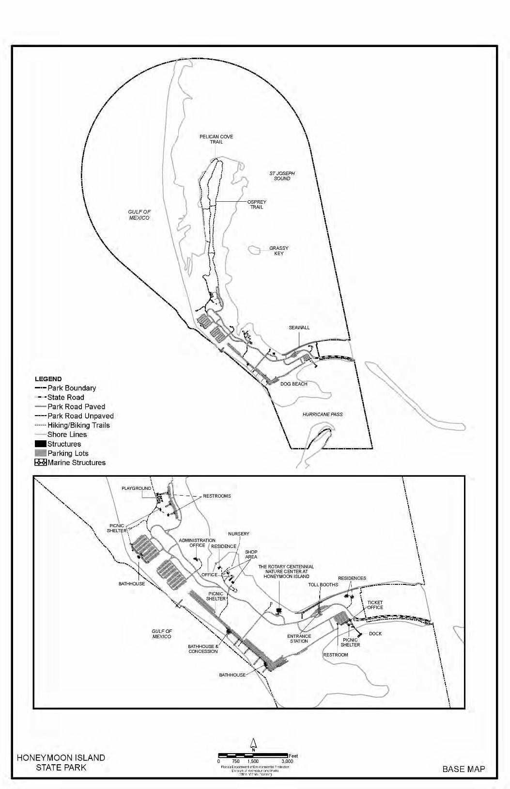
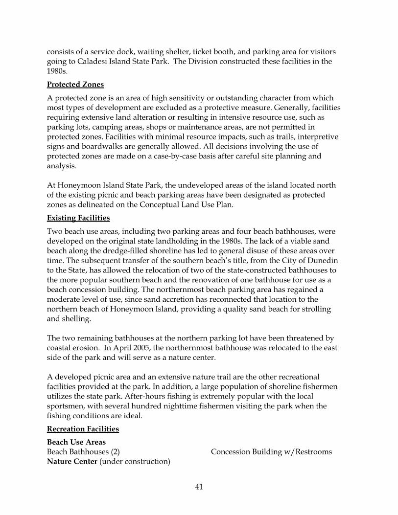
41
consists of a service dock, waiting shelter, ticket booth, and parking area for visitors going to Caladesi Island State Park. The Division constructed these facilities in the 1980s.
Protected Zones
A protected zone is an area of high sensitivity or outstanding character from which most types of development are excluded as a protective measure. Generally, facilities requiring extensive land alteration or resulting in intensive resource use, such as parking lots, camping areas, shops or maintenance areas, are not permitted in protected zones. Facilities with minimal resource impacts, such as trails, interpretive signs and boardwalks are generally allowed. All decisions involving the use of protected zones are made on a case-by-case basis after careful site planning and analysis. At Honeymoon Island State Park, the undeveloped areas of the island located north of the existing picnic and beach parking areas have been designated as protected zones as delineated on the Conceptual Land Use Plan.
Existing Facilities
Two beach use areas, including two parking areas and four beach bathhouses, were developed on the original state landholding in the 1980s. The lack of a viable sand beach along the dredge-filled shoreline has led to general disuse of these areas over time. The subsequent transfer of the southern beach’s title, from the City of Dunedin to the State, has allowed the relocation of two of the state-constructed bathhouses to the more popular southern beach and the renovation of one bathhouse for use as a beach concession building. The northernmost beach parking area has regained a moderate level of use, since sand accretion has reconnected that location to the northern beach of Honeymoon Island, providing a quality sand beach for strolling and shelling. The two remaining bathhouses at the northern parking lot have been threatened by coastal erosion. In April 2005, the northernmost bathhouse was relocated to the east side of the park and will serve as a nature center. A developed picnic area and an extensive nature trail are the other recreational facilities provided at the park. In addition, a large population of shoreline fishermen utilizes the state park. After-hours fishing is extremely popular with the local sportsmen, with several hundred nighttime fishermen visiting the park when the fishing conditions are ideal.
Recreation Facilities Beach Use Areas Beach Bathhouses (2) Concession Building w/Restrooms Nature Center (under construction)
42
Picnic Area Picnic Shelters (2) Restrooms (2)
Playground Osprey Nature Trail (2.4 miles)
Support Facilities Entrance Area Ranger Station Toll Booths (2) Shop Area Shop Building Carpentry Building Plant Nursery
Assistant Manager’s Office Flammable Storage Building
Other Support Buildings Administration Programs Building Residences (2) Beach Parking Areas North Beach – 485 spaces Middle Beach – 432 spaces
Main Beach – 785 spaces Dog Beach – 24 spaces
Roads Park Road – 2.4 miles Service Roads – 2.4 miles Caladesi Island Land Base Shelter w/Restrooms Storage Building Ticket Booth
Docks – 5 slips Parking – 153 spaces
CONCEPTUAL LAND USE PLAN
The following narrative represents the current conceptual land use proposal for this park. As new information is provided regarding the environment of the park, cultural resources, recreational use, and as new land is acquired, the conceptual land use plan may be amended to address the new conditions (see Conceptual Land Use Plan). A detailed development plan for the park and a site plan for specific facilities will be developed based on this conceptual land use plan, as funding becomes available. During the development of the unit management plan, the Division assesses potential impacts of proposed uses on the resources of the property. Uses that could result in unacceptable impacts are not included in the conceptual land use plan. Potential impacts are more thoroughly identified and assessed through the site planning process once funding is available for the development project. At that
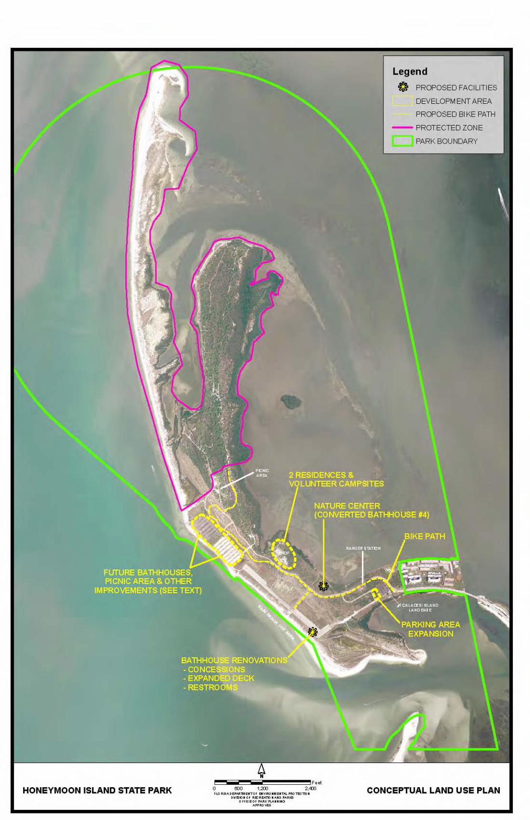
44
stage, design elements, such as sewage disposal and stormwater management, and design constraints, such as designated species or cultural site locations, are more thoroughly investigated. Advanced wastewater treatment or best available technology systems are applied for on-site sewage disposal. Stormwater management systems are designed to minimize impervious surfaces to the greatest extent feasible, and all facilities are designed and constructed using best management practices to avoid impacts and to mitigate those that cannot be avoided. Federal, state and local permit and regulatory requirements are met by the final design of the projects. This includes the design of all new park facilities consistent with the universal access requirements of the Americans with Disabilities Act (ADA). After new facilities are constructed, the park staff monitors conditions to ensure that impacts remain within acceptable levels.
Potential Uses and Proposed Facilities
The current forms of outdoor recreation should be continued as Honeymoon Island State Park provides a valuable resource for beach recreation, picnicking, hiking and nature study in the Pinellas County area. In addition to the existing uses and facilities, the following is proposed:
Recreation Facilities
Coastal Engineering and Beach Renourishment. One of the major reasons the state had for acquiring Honeymoon Island was to provide a regional beach recreation area in this urban area. Since its inception, Honeymoon Island State Park has been very popular; always ranking among the most visited in the state park system. However, its popularity and role as a public beach provider has been gradually declining over the past few years as sand along the developed beach areas has been migrating to the less accessible and more sensitive areas of the island. The Division has made a commitment to finding a long-term solution to keep sand on the developed beach areas. The solution will involve an extensive evaluation of the existing situation and may require coastal engineering structures and periodic beach renourishment. The Division will work closely with the Bureau of Beaches and Coastal Systems, the Florida Fish and Wildlife Conservation Commission, and Pinellas County to develop the best strategy. Bathhouse Renovations. Unfortunately, the Division cannot guarantee a permanent sandy beach in front of all the existing beach use facilities. As a consequence, existing restrooms and food concessions may need to be relocated, modified, or expanded over time to match the visitor use patterns and needs. In addition, a new bathhouse may also be needed in the future. At this time, the Division has decided to renovate bathhouse #1, the southernmost bathhouse, to improve visitor services. Renovations may include a food concession operation with a kitchen/service area and large covered deck, in addition to the necessary restroom facilities it currently provides.
45
Interpretive Improvements and Nature Center. Honeymoon Island State Park, the adjacent units of the state park system, St. Joseph Sound, the Gulf of Mexico, and the historic settlement areas of the mainland provide a wealth of natural resources, wildlife, and history for a well-rounded interpretive program at the park. The park has already developed a Statement for Interpretation document and currently provides a variety of Ranger-led programs and maintains numerous interpretive displays. However, there is potential to further develop the interpretive programming at the park. A nature center is currently being developed to support interpretive programs by Division staff and by others who have interests in communicating the natural and cultural values of this area. Bathhouse # 4, which was critically threatened by coastal erosion, was relocated in 2005 to the east side of the park overlooking St. Joseph Sound and is currently undergoing renovations to serve as the new nature center. It will be known as the Rotary Centennial Nature Center at Honeymoon Island State Park. Prominent interpretive themes will be: 1) the dynamics of barrier island formation and change (including the dramatic
impact of hurricanes), and how human manipulations along this coast have affected the dynamics of these islands;
2) the ecology of St. Joseph Sound with emphasis on the importance of sea grass beds and how human activities can threaten them;
3) the special importance of these islands to shorebird nesting and the challenge of managing recreational activities to protect the birds;
4) the role of prescribed burning and the threat of invasive exotics; 5) and the history of the islands to include archaeological excavation of the burial
mound on Caladesi Island, the pioneer Henry Scharrer and his daughter, the honeymoon cottages that gave Honeymoon Island its name, and the historical background provided by the Dunedin Historical Society.
Additional interpretive displays are recommended for the beach use areas to educate visitors about the recreational impacts to shorebirds and nesting turtles. As discussed in the Resource Management Component of this plan, nesting sea turtles and resting and nesting listed shorebirds utilize the beach areas of the park, primarily the northern beachfront extending north from the developed beach areas of the park. This area of beach has become more popular with park visitors in recent years due to the loss of sand at the developed beach use areas. The interpretive displays should explain how visitors can minimize their impacts on the wildlife and should highlight recent research done within the state park system. Reconfiguration of Special Events Parking Lot. Due to the current lack of sandy beach and absence of recreational facilities at one of the large beach parking lots at the north end of the park (see Conceptual Land Use Plan), this area is only being
46
used during special events. If the Division is unable to maintain a sand beach for this area of the park, improvements are recommended to better suit the needs of the organized events while also making it more attractive to visitors the rest of the year. Plans include replacing a significant amount of the pavement with grass and native landscaping to create an open, green space capable of supporting large gatherings of people on occasion while serving as a picnic area and recreational field the rest of the year. Picnic shelters capable of supporting the special events and a restroom are recommended for this area. Bicycle Path. Currently, the Honeymoon Island Spur Trail, which links the state park to the Pinellas Trail, ends at the park entrance. A paved bicycle path is recommended alongside the park road to allow visitors a safer route from the entrance gate to the beach use areas and the other recreation facilities. The bicycle path should be separated from the park road wherever possible to maximize safety.
Support Facilities
Approximately 75 additional parking spaces are needed to manage peak visitation periods at the Caladesi Island Land Base. The expansion should be located immediately adjacent to the existing paved parking area. Up to two additional residences and three additional volunteer RV campsites are recommended for the shop area to support park staff and volunteers. In addition, the city sewer line should be extended to the shop area so all park facilities are connected.
Facilities Development
Preliminary cost estimates for the following list of proposed facilities are provided in Addendum 6. These cost estimates are based on the most cost-effective construction standards available at this time. The preliminary estimates are provided to assist the Division in budgeting future park improvements, and may be revised as more information is collected through the planning and design processes.
Recreation Facilities Interpretive Improvements and Nature Center Nature Center
Parking (12 spaces) Landscaping (20,000 square feet)
Interpretive Displays (3)
Bathhouse Renovations
Kitchen Food Service Area
Covered Deck (1500 sq.ft.) Restrooms
47
Special Events Parking Lot Large Picnic Shelters (2) Restroom
Landscaping (110,000 square feet)
Bicycle Path Extension (1.5 miles)
Support Facilities Caladesi Island Land Base Parking Lot Expansion (75 spaces) Maintenance Area Ranger Residences (2) Volunteer RV Campsites (3)
Sewer Line Extension (900 feet) and Lift Station
Existing Use and Optimum Carrying Capacity
Carrying capacity is an estimate of the number of users a recreation resource or facility can accommodate and still provide a high quality recreational experience and preserve the natural values of the site. The carrying capacity of a unit is determined by identifying the land and water requirements for each recreation activity at the unit, and then applying these requirements to the unit's land and water base. Next, guidelines are applied which estimate the physical capacity of the unit's natural communities to withstand recreational uses without significant degradation. This analysis identifies a range within which the carrying capacity most appropriate to the specific activity, the activity site and the unit's classification is selected (see Table 1). The optimum carrying capacity for this park is a preliminary estimate of the number of users the unit could accommodate after the current conceptual development program has been implemented. When developed, the proposed new facilities would approximately increase the unit's carrying capacity as shown in Table 1.
Optimum Boundary
As additional needs are identified through park use, development, research, and as adjacent land uses change on private properties, modification of the unit's optimum boundary may occur for the enhancement of natural and cultural resources, recreational values and management efficiency. At this time, no additional lands are identified for acquisition and, no lands are considered surplus to the needs of the park.
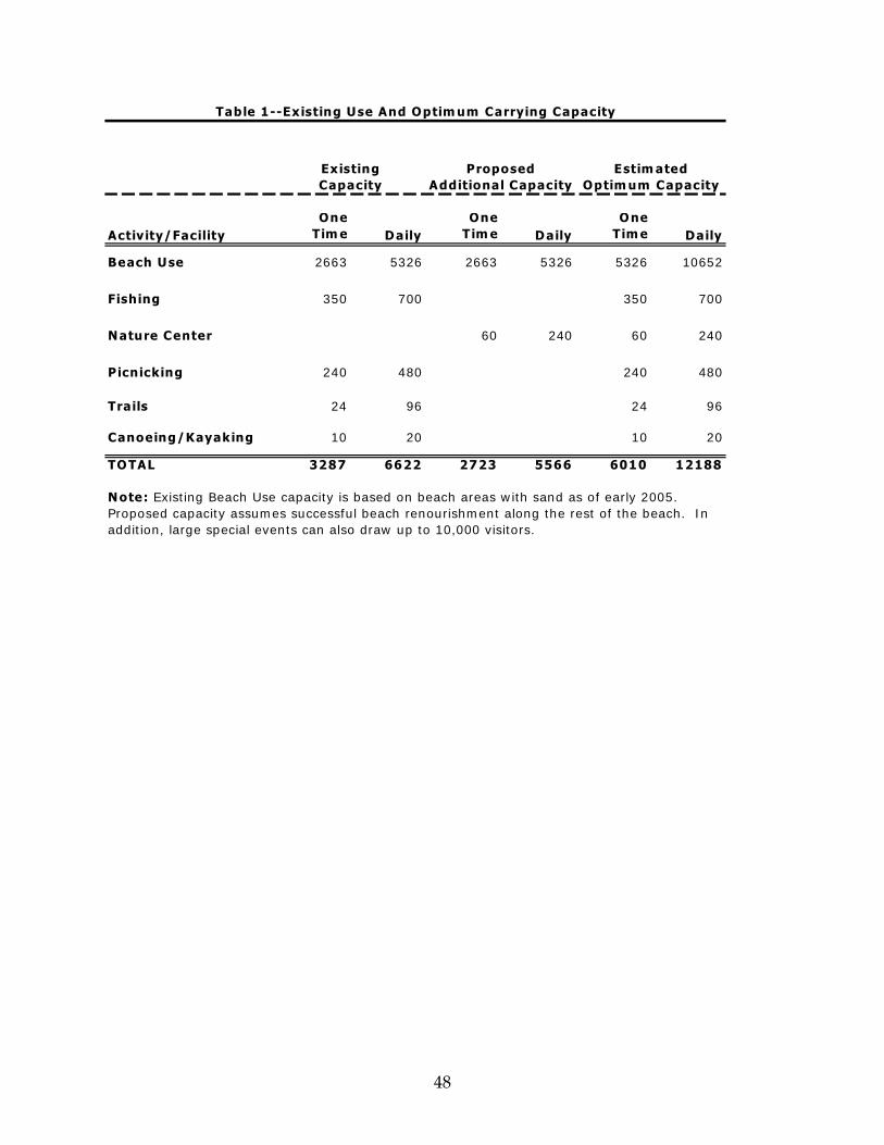
48
Activity/FacilityOne
Tim e D ailyOne
Tim e D ailyO ne
Tim e Daily
Beach Use 2663 5326 2663 5326 5326 10652
Fishing 350 700 350 700
N ature Center 60 240 60 240
Picnicking 240 480 240 480
Trails 24 96 24 96
Canoeing/Kayaking 10 20 10 20
TO TAL 3287 6622 2723 5566 6010 12188
N ote: Existing Beach Use capacity is based on beach areas w ith sand as of early 2005. Proposed capacity assumes successful beach renourishment along the rest of the beach. In addition, large specia l events can also draw up to 10,000 vis itors.
Proposed Additional Capacity
Existing Capacity
Estim ated Optim um Capacity
Table 1--Existing Use And Optim um Carrying Capacity

Addendum 1—Acquisition History and Advisory Group Documentation

Honeymoon Island State Park Acquisition History
A 1 - 1
Sequence of Acquisition On December 23, 1974, the Board of Trustees of the Internal Improvement Trust Fund (the Trustees) obtained title to a 113.56-acre property which later became Honeymoon Island State Park. The property was purchased from Hyman Green for $7,000,000 under the Land Acquisition Trust Fund (LATF) program. Between 1974 and 1982, the Trustees acquired several parcels for incorporation into the park. The acquisitions were made through the LATF, the federal Land and Water Conservation Fund (LWCF), or by donations. On December 7, 1981, the Trustees conveyed management authority of Honeymoon Island State Park to the Department of Environmental Protection, Division of Recreation and Parks (Division) under Lease No. 3203. Title Interest The Trustees hold fee simple title Honeymoon Island State Park. The Division manages the recreation area under Lease No. 3203 for a period of fifty (50) years. The lease will expire on December 7, 2031. Special Conditions on Use In accordance with the Division’s lease agreement with the Trustees, the property must be utilized for public outdoor recreation and related purposes. Uses such as, water resource development projects, water supply projects, stormwater management projects, linear facilities and sustainable agriculture and forestry (other than those forest management activities specifically identified in this plan) are not consistent with this plan. In accordance the LWCF program, the property must be retained solely for public outdoor recreation use. Outstanding Reservations There are no outstanding reservations and encumbrances which apply to Honeymoon Island State Park.

Honeymoon Island State Park Acquisition History
A 1 - 2
Caladesi Island and Honeymoon Island State Parks Advisory Group List
A 1 - 3
The Honorable Susan Latvala Pinellas County Board of County Commissioners Pinellas County Courthouse 5th Floor 315 Court Street Clearwater, Florida 33756 The Honorable John A. Doglione, Mayor City Hall 542 Main Street Dunedin, Florida 34698 Represented by: Harry Gross 903 Michigan Boulevard Dunedin, Florida 34698 Mr. Peter Krulder, Park Manager Honeymoon Island State Park No. 1 Causeway Boulevard Dunedin, Florida 34698 Ms. Nancy Douglass, Wildlife Biologist Florida Fish and Wildlife Conservation Commission 3900 Drane Field Road Lakeland, Florida 33811 Mr. Gary Zipprer, District Manager Lakeland District Office Florida Division of Forestry 5745 South Florida Avenue Lakeland, Florida 33813 (863) 648-3163 Dr. Randy Runnels Tampa Bay Aquatic Preserves P.O. Box 309 Terra Ceia, Florida 34250
Mr. Hugh Grambling, Chair Hillsborough Soil and Water Conservation District 1311 South Parsons Avenue Seffner, Florida 33584-4573 Ms. Sally Hess, President Friends of the Island Parks, Inc. 423 Grant Street Dunedin, Florida 34698 Mr. David Carson, Chairman Dunedin Chamber of Commerce 440 Douglas Avenue Dunedin, Florida 34698 Mr. Hank Brooks, President Tampa Bay Sea Kayakers 107 Marshall Street Safety Harbor, Florida 34695 Mr. Joe Lopez 1688 Hamilton Court Dunedin, Florida 34698 Mr. Ray Kingsbury 2440 State Road 580, Suite 14 Clearwater, Florida 33761 Ms. Cathy Harrelson, Group Chair Sierra Club – Suncoast Group 4460 Indianapolis Street NE St. Petersburg, Florida 33703 Represented by: Michael Miller 821 Woodcrest Avenue Clearwater, Florida 33756 Ms. Ann Paul Florida Coastal Island Sanctuaries 410 Ware Boulevard, Suite 702 Tampa, Florida 33619
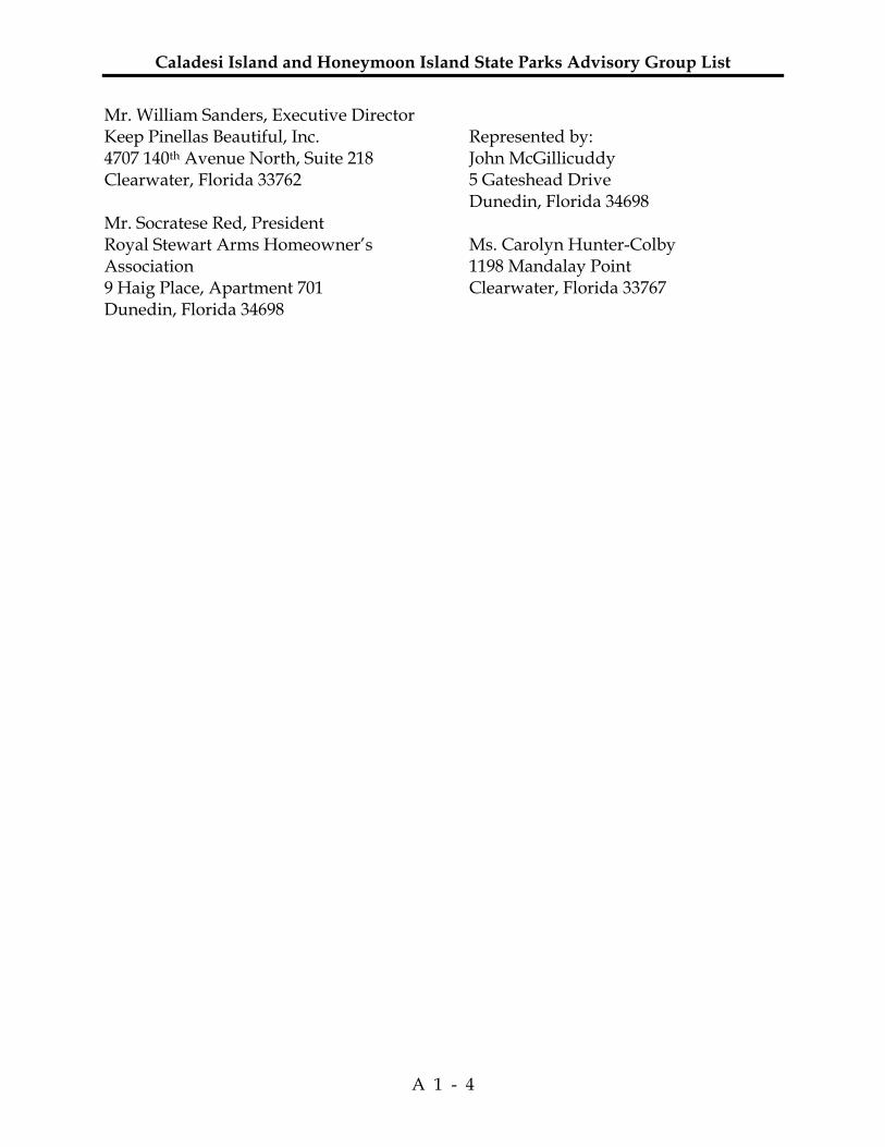
Caladesi Island and Honeymoon Island State Parks Advisory Group List
A 1 - 4
Mr. William Sanders, Executive Director Keep Pinellas Beautiful, Inc. 4707 140th Avenue North, Suite 218 Clearwater, Florida 33762 Mr. Socratese Red, President Royal Stewart Arms Homeowner’s Association 9 Haig Place, Apartment 701 Dunedin, Florida 34698
Represented by: John McGillicuddy 5 Gateshead Drive Dunedin, Florida 34698 Ms. Carolyn Hunter-Colby 1198 Mandalay Point Clearwater, Florida 33767
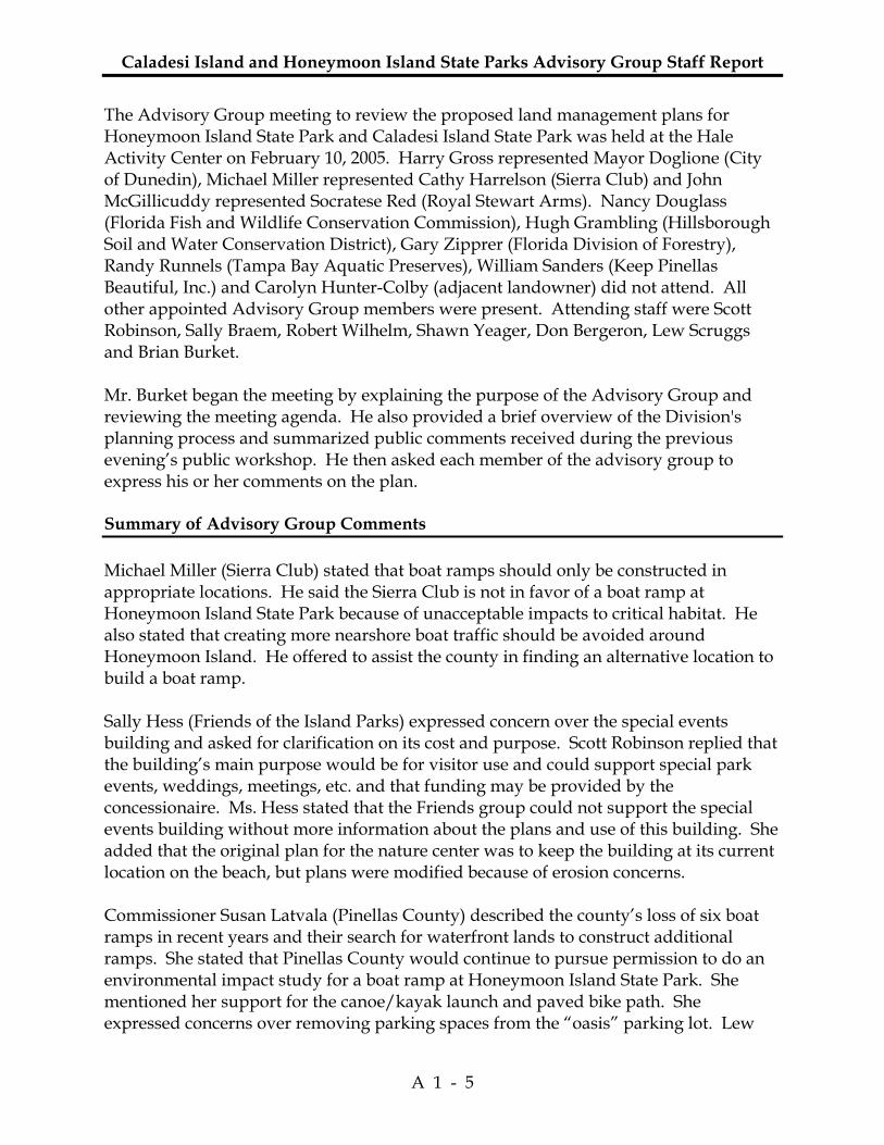
Caladesi Island and Honeymoon Island State Parks Advisory Group Staff Report
A 1 - 5
The Advisory Group meeting to review the proposed land management plans for Honeymoon Island State Park and Caladesi Island State Park was held at the Hale Activity Center on February 10, 2005. Harry Gross represented Mayor Doglione (City of Dunedin), Michael Miller represented Cathy Harrelson (Sierra Club) and John McGillicuddy represented Socratese Red (Royal Stewart Arms). Nancy Douglass (Florida Fish and Wildlife Conservation Commission), Hugh Grambling (Hillsborough Soil and Water Conservation District), Gary Zipprer (Florida Division of Forestry), Randy Runnels (Tampa Bay Aquatic Preserves), William Sanders (Keep Pinellas Beautiful, Inc.) and Carolyn Hunter-Colby (adjacent landowner) did not attend. All other appointed Advisory Group members were present. Attending staff were Scott Robinson, Sally Braem, Robert Wilhelm, Shawn Yeager, Don Bergeron, Lew Scruggs and Brian Burket. Mr. Burket began the meeting by explaining the purpose of the Advisory Group and reviewing the meeting agenda. He also provided a brief overview of the Division's planning process and summarized public comments received during the previous evening’s public workshop. He then asked each member of the advisory group to express his or her comments on the plan. Summary of Advisory Group Comments Michael Miller (Sierra Club) stated that boat ramps should only be constructed in appropriate locations. He said the Sierra Club is not in favor of a boat ramp at Honeymoon Island State Park because of unacceptable impacts to critical habitat. He also stated that creating more nearshore boat traffic should be avoided around Honeymoon Island. He offered to assist the county in finding an alternative location to build a boat ramp. Sally Hess (Friends of the Island Parks) expressed concern over the special events building and asked for clarification on its cost and purpose. Scott Robinson replied that the building’s main purpose would be for visitor use and could support special park events, weddings, meetings, etc. and that funding may be provided by the concessionaire. Ms. Hess stated that the Friends group could not support the special events building without more information about the plans and use of this building. She added that the original plan for the nature center was to keep the building at its current location on the beach, but plans were modified because of erosion concerns. Commissioner Susan Latvala (Pinellas County) described the county’s loss of six boat ramps in recent years and their search for waterfront lands to construct additional ramps. She stated that Pinellas County would continue to pursue permission to do an environmental impact study for a boat ramp at Honeymoon Island State Park. She mentioned her support for the canoe/kayak launch and paved bike path. She expressed concerns over removing parking spaces from the “oasis” parking lot. Lew
Caladesi Island and Honeymoon Island State Parks Advisory Group Staff Report
A 1 - 6
Scruggs replied that the Division is looking at options that would not involve the removal of pavement. Hank Brooks (kayaking representative) expressed his general approval of boat ramps, but does not support the construction of ramps that cause unacceptable environmental impacts. He voiced is appreciation for the proposed canoe/kayak launch but stated that some users may continue to launch from the causeway because it is free. He, then, asked for clarification about the optimum boundary for Caladesi Island. Brian Burket responded that the land identified on the optimum boundary map is for planning purposes only and that it would require a willing seller to acquire. John McGillicuddy (Royal Stewart Arms) expressed concern that the proposed bike path would result in trespassing within Royal Stewart Arms. Mr. Robinson replied that the Honeymoon Spur of the Pinellas Trail already comes to the entrance of the park and that the plan addresses the need to provide a safer route within the park for those arriving on foot or bicycle. Mr. McGillicuddy requested consideration for discounts for Royal Stewart Arms residents. Joe Lopez (boating representative) stated his appreciation for the wonderful job done by the park staff. He said he enjoys the new kayaking trail on Caladesi Island, appreciates the water/electric hook-ups at the boat slips and supports the idea for a bathhouse for the marina area. He recommended expanding the volunteer program. David Carson (Dunedin Chamber of Commerce) stated that he cannot speak officially for the Chamber, but shared his personal views. He expressed his appreciation to Pinellas County for their search for an appropriate location to construct a boat ramp, but recommended that launching boats from the Dunedin Causeway be eliminated. He mentioned that he regularly rides his bike along the park road and supports the proposal for a separate bike path as well as the kayak launch. Ann Paul (National Audubon) acknowledged the fine work of the park staff and the quality of the draft plans. She stated her approval for keeping the proposed facilities within the developed areas of the parks, thus protecting the wild areas. She recognized these parks as outstanding birding areas and that the efforts to protect shorebirds are first rate. She stated that the interpretive improvements are very important and should be incorporated with local school programs. She stated her approval of the terrestrial predator control program and said the exotic plant removal efforts are exemplary. She recommends consideration for creating freshwater wetlands within the ruderal areas. She expressed concern about the environmental impacts of a boat ramp in the ferry cove and offered to help the county find a more suitable location. She also said she was glad to see that cabins are not proposed for Honeymoon Island State Park. She stated that the optimum boundary property should be pursued to help buffer Caladesi Island State Park from potential development along Clearwater Beach. She suggested that the park
Caladesi Island and Honeymoon Island State Parks Advisory Group Staff Report
A 1 - 7
buy jet skis to aid enforcement of the motor exclusion zones. She also recommended that the special events building be a temporary/removable structure. Ray Kingsbury (fishing representative) stated that fishermen are most concerned with environmental impacts on the marine grass beds and is therefore opposed to the boat ramp in the ferry cove. He said the boat ramp would ruin the cove and that boating congestion in the area is already excessive. He recommended more trash cans be placed in high use areas. He supported the kayak launch as long as the grass beds are not impacted. He also supported the proposed nature center and its educational use. He stated that enforcement of fishing regulations and jet skis use needs to be improved. He then asked if any studies have looked at the environmental impact of special events at the state parks. Sally Braem responded that biologists review the proposals for new events to ensure there are no significant impacts. Harry Gross (City of Dunedin) stated that the City of Dunedin supports Pinellas County’s request to study the environmental impact of a boat ramp at Honeymoon Island State Park. He said the city supports all efforts to place sand on the beach at Honeymoon Island State Park. He mentioned the city/county effort to solicit public input for their Dunedin Causeway Master Plan. He requested that the park-specific annual pass be reinstated. He also voiced concern that the city may not be able to provide support services for additional special events at Honeymoon Island if a special events building is constructed. Scott Robinson (Park Manger) thanked the advisory group for their comments and their support of these state parks. Summary of Public Comments Jack McNichols congratulated the staff for doing an excellent job in managing the state parks. He stated that the primary goal should be to keep development at a minimum in order to preserve natural Florida. He said the ferry cove is too shallow for a boat ramp and that it would ruin the cove. He also mentioned that he does not believe Honeymoon Island State Park needs a special events building. Aydelette Kelsey requested that the public have an opportunity to review the advisory group drafts of the management plans and recommended that the Acquisition and Restoration Council hold their final review of these plans locally. She also stated that a boat ramp would have unacceptable environmental impacts and encouraged the Division stay firm on their decision not to support its construction. Richard Selleg suggested, “Less is more” and encouraged the park to restrict further development. He voiced his support for the kayak launch and denial of the boat ramp. He suggested an alternative location for a boat ramp on the Dunedin Causeway. He
Caladesi Island and Honeymoon Island State Parks Advisory Group Staff Report
A 1 - 8
also recommended that a temporary structure be used for special events instead of constructing the proposed special events building. James Richter agreed with Mr. McNichols’ statements. He mentioned that he rides his bicycle in Honeymoon Island but does not support the proposed bike path because of potential impacts to birds. He recommended, instead, increasing signage and visitor education about sharing the roadway. Gabrielle Mullins expressed concern over the proposed special events building. She stated that exclusive uses should not be allowed in the state parks. Staff Recommendations The staff recommends approval of the proposed management plans for Honeymoon Island State Park and Caladesi Island State Park as presented with the following changes:
Honeymoon Island State Park
Boat Ramp. After careful consideration, the Division has determined that constructing a boat ramp at Honeymoon Island State Park would damage endangered mangroves and sensitive sea grasses, which provide important wildlife habitat. A park boat ramp would also increase traffic and road congestion for our neighbors living outside the park. Special Events Building. The proposal for a special events building, as discussed in the management plan, has been removed. Beach Bathhouses. The Division has made a commitment to finding a long-term solution to keep sand on the developed beach areas. Unfortunately, the Division cannot guarantee a permanent sandy beach in front of all the existing beach use facilities. Consequently, existing restrooms and food concessions may need to be relocated, modified or expanded over time to match the visitor use patterns and needs. In addition, a new bathhouse may also be needed in the future. At this time, the Division has decided to renovate bathhouse #1, the southernmost bathhouse, to improve visitor services that may include a food concession operation with a kitchen and service area, a large covered deck, in addition to the necessary restroom facilities it currently provides. Bike Path. The Division has discussed and supports a separate bicycle path because of safety concerns and believes it can be constructed in a way that minimizes impact to nesting birds. Canoe/Kayak Launch. The recommendation for a canoe/kayak launch on St. Joseph
Caladesi Island and Honeymoon Island State Parks Advisory Group Staff Report
A 1 - 9
Sound has been removed from the conceptual plan for Honeymoon Island State Park. After further analysis, it was determined that a canoe/kayak launch anywhere along this shoreline would result in significant impact to mangroves, sea grasses, and resting shorebirds. The launching of canoes and kayaks is available along the park’s gulf shoreline as well as on Dunedin Causeway.
Caladesi Island State Park Observation Platform. If feasible, the design of the proposed open-air interpretive pavilion could include an observation platform to provide a scenic panorama of the island’s natural communities.

Caladesi Island and Honeymoon Island State Parks Advisory Group Staff Report
A 1 - 10

Addendum 2—References Cited


Honeymoon Island State Park References Cited
A 2 - 1
Bard, A.M. 1992. The status of the seagrass community of St. Joseph Sound adjacent to Honeymoon Island State Recreation Area and Caladesi Island State Park, Pinellas County, Florida: ecology, distribution and recommendations for management. District 5 Technical Report No. 1, Florida Dept. Of Nat. Res., Tallahassee, FL. 47 pp.
Bureau of Economic and Business Research (BEBR), University of Florida. 2005. Florida
Statistical Abstract 2005. Gainesville, Florida. Douglass, N.J. 1997. Regional Nongame Biologist, South region, Florida Game and Fresh
Water Fish Commission. Personal communication. Dunedin. 1997. Dunedin 2015 - The Comprehensive Plan. Dunedin, Florida. Florida Department of Environmental Protection. 2006. Florida State Park System
Economic Impact Assessment for Fiscal Year 2005/2006. Tallahassee, Florida. FMRI. 1993. Statewide assessment of propeller scar damage in seagrass beds. Geographic
Information System Map. Florida Marine Research Institute, Dept. Of Env. Protection. Based on 1992-1993 Aerial Survey.
Helmers, D.L. 1992. Shorebird Management Manual. Western Hemisphere Shorebird
Reserve Network, Manumit, MA. 58 pp. Herwitz, S. 1977. The natural history of Cayo Costa Island. New College Environmental
Studies, Sarasota, Florida. HPIMP. 1993. Hurricane Pass Inlet Management Plan. Submitted to Pinellas County
Department of Public Works, Clearwater, Florida by Applied Technology and Management, Inc., Gainesville, Florida. 90 pp.
Inglin, D.C. and R.A. Davis, Jr. 1993. Honeymoon Island study phase four: three year
monitoring report. Coastal Research Laboratory of the Department. of Geology, University of South Florida, Tampa, FL. 68 pp.
Johnson, A.F. and J.W. Muller. 1993. An assessment of Florida’s remaining coastal upland
natural communities: Southwest Florida. Florida Natural Areas Inventory, Tallahassee, FL.
Montague, C.L. and R.G. Weigert. 1990. Salt marshes, PP 481-516 in Ecosystems of
Florida. R.L. Myers and J.J. Ewel, eds. University of Central Florida Press, Orlando. 765 pp.
Honeymoon Island State Park References Cited
A 2 - 2
Moore, C.B. 1903. Certain aboriginal mounds of the Florida Central West-Coast. Available from the Florida State Geological Survey, Tallahassee, FL. (Only excerpt of pages 433-434 seen.)
Rodgers, J.A., Jr. And H.S. Smith. 1995. Set-back distances to protect nesting bird colonies
from human disturbance in Florida. Conservation Biology 9 : 89-99. Smith, K. 1998. A summary of limited vessel entry zones for managed seagrass protection
in Florida. Bureau of Protected Species Management, Florida Dept. of Environmental Protection, Tallahassee, FL. 30 pp.
Sprandel, G.L., J.A. Gore and D.T. Cobb. 1997. Winter shorebird survey. Florida Game
and Fresh Water Fish Comm. Final Perf. Rep. Tallahassee. 162 pp. + vi. U. S. Department of Commerce, Bureau of the Census. 2000. U. S. Census 2000. Vanatta, E.S., Jr., L.T. Stem, W.H. Wittstruck, D.E. Petry, and J.W. Spieth. 1972. Soil
Survey of Pinellas County, Florida. In cooperation with the University of Florida Agricultural Experiment Stations. USDA, Soil Cons. Serv. 106 pp.
Zieman, J.C. and R.T. Zieman. 1989. The ecology of the seagrass meadows of the west
coast of Florida: a community profile. U.S. Fish and Wildlife Service, Biological Report 85(7.25). 155 pp.

Addendum 3—Soils Descriptions

Honeymoon Island State Park
Soils Descriptions
A 3 - 1
Coastal beaches (Co) - Coastal beaches consists of narrow strips of tide-washed sand bordering islands and parts of the mainland. Most area are covered during storms and daily at high tide. These beaches range from a few feet to as much as 500 feet in width. Long stretches are practically without vegetation, but sparse salt-tolerant grasses and other plants grow in places. Depth to the water table varies with the tide. The beach sand has been deposited, mixed, and reworked by waves. It is firm or compact when moist and loose when dry. This sand is light gray to white and consists mainly of fine quartz particles in which there are varying quantities of medium to coarse shell fragments. The sand contains a few, fine, rounded, weakly cemented very dark gray to very dark brown particles. Coastal beaches is used primarily for recreation. It provides habitat for shore birds. (No capability classification; woodland group 9)
Made land (Ma) - This consists of mixed sand, clay, hard rock, shells, and shell fragments that have been transported, reworked, and leveled by earth-moving equipment. Many areas consist of material that has been dredged from the bay and used to fill diked areas. Coarser sludge materials are deposited near the outlet of discharge pipes andfiner materials settle in more distant positions. Rocks 1/2 inch to 12 inches in diameter are common. Numerous silicified oyster shells and some animal fossils occur in these materials. Stratification is apparent in the water-transported material. Materials transported by truck are similar but they usually are sandier and do not contain silicified shells and fossils. Made land in underlain at a depth of 2 to 8 feet by various kinds of material. In some areas it is underlain by the sandy bay bottom, and in others by Tidal swamp that has layers of fibrous peat 20 inches or less thick. Some of the material transported by truck has been deposited over solid rubble consisting of chunks of concrete, discarded appliances, and broken asphalt. Made land occurs mainly in urban areas, along the coast and keys, and as manmade islands built in shallow water. In coastal areas it has been built up to provide desirable locations for residential development. Recently deposited material shows very little profile development and has severe limitations for plants. Topsoil, irrigation, and special fertilizers are needed for good growth of lawns and ornamental plants. (No capability classification; woodland group 9) St. Lucie fine sand, shell substratum (Su) - This is a nearly level soil on low ridges on barrier islands in the western part of the county. In most places the surface layer is very dark gray fine sand about 3 inches thick. Below this is light-gray loose fine sand about 34 inches thick. The next layer is very pale brown, loose fine sand that extends to a depth of 40 inches or more. This is underlain by layers of mixed light-gray or white sand, seashells, and shell fragments. Reaction is medium acid in the surface layer and mildly alkaline below. The water table is at a depth of 40 to 60 inches for 6 months or more in most years. It is within 40 inches for less than 60 days. Included in mapping are small areas of Palm Beach sand that make up no more than 15 percent of any mapped area and of Made land that make up as much as 5 percent.
Honeymoon Island State Park
Soils Descriptions
A 3 - 2
Most areas of St. Lucie fine sand, shell substratum, are in State or county parks or have been used for building lots. No areas are available for farming. (Capability unit VIs-2; woodland group 3). Tidal swamp (Ts) - Tidal swamp is on small islands and in low, broad coastal areas that are covered with sea water. It occurs mostly in the southeastern part of the county. The water is several inches deep at low tide and 1 or 2 feet deep at high tide. Tidal swamp differs from Tidal marsh mainly in vegetation. Tidal swamp has a thick growth of mangrove trees and a few small patches of salt-tolerant plants. Tidal swamp is subject to wave action, whereas Tidal marsh usually is not.
This land type consists mainly of sand, peaty sand, a few organic soils, seashells, and shell fragments. The dense forest of mangrove trees and high water make detailed investigation of the soils impractical. In places the surface layer is fibrous peat, 6 to 18 inches thick, over gray to pale-brown sand mixed with shell fragments. In places the surface layer is sandy clay and the subsurface layers are loam or marl. Other areas are stratified sand and organic material. Most areas contain varying amounts of seashells and shell fragments at irregular depths. Tidal swamp is not extensive in the county. It is mainly a source of food, cover, and breeding grounds for numerous shore birds and animals. Many mosquito-control ditches have been dug in most areas to remove water trapped buy falling tides. The shallow water in these ditches provides food and breeding areas for may species of fish. Some areas in the vicinity of St. Petersburg, Clearwater, and Honeymoon Island have been filled with dredged material to provide waterfront homesites. (No capability classification; woodland group 9)

Addendum 4—Plant And Animal List


Honeymoon Island State Park
Plants Primary Habitat Codes Common Name Scientific Name (for designated species)
* Non-native Species A 4 - 1
Rosary pea * Abrus precatorius Pineland acacia Acacia pinetorum Giant leather fern Acrostichum danaeifolium Saltmarsh false foxglove Agalinis maritima Hammock thoroughwort Ageratina jucunda Florida amaranth Amaranthus floridanus Spiny amaranth * Amaranthus spinosa Common ragweed Ambrosia artemisiifolia Toothcups Ammania latifolia Peppervine Ampelopsis arborea Bushy bluestem Andropogon glomeratus var. pumilus Broomsedge Andropogon virginicus Arrowfeather Aristida purpurascens Sand atriplex Atriplex cristata Black mangrove Avicennia germinans Saltbush Baccharis halimifolia Coastal water-hyssop Bacopa monnieri Saltwort Batis maritima Spanish needles; Beggar-ticks Bidens alba var. radiata Seaside oxeye Borrichia frutescens American blueheart Buchnera americana Gray nicker Caesalpinia bonduc Coastal searocket Cakile lanceolata American beautyberry Callicarpa americana Seaside bean Canavalia rosea Love vine; Devil's-gut Cassytha filiformis Coast sandspur Cenchrus spiniflex Spurred butterfly-pea Centrosema virginianum Partridge pea; Sleepingplant Chamaecrista fasciculata Partridge pea Chamaecrista nictitans var. aspera Dixie sandmat Chamaesyce bombensis Pill-pod sandmat Chamaesyce hirta Hyssop-leaf sandmat Chamaesyce hyssopifolia Spotted sandmat Chamaesyce maculata Coastal-beach sandmat Chamaesyce mesembrianthemifolia Pigweed Chenopodium album Mexican tea * Chenopodium ambrosioides Snowberry Chiococca alba Yellow thistle Cirsium horridulum Tread-softly; Finger-rot Cnidoscolus stimulosus Seagrape Coccoloba uvifera Erect dayflower Commelina erecta Buttonwood Conocarpus erectus

Honeymoon Island State Park
Plants Primary Habitat Codes Common Name Scientific Name (for designated species)
* Non-native Species A 4 - 2
Dwarf horseweed Conyza canadensis var. pusilla Leavenworth's tickseed Coreopsis leavenworthii Smooth rattlebox * Crotalaria pallida var. obovata Rabbit-bells Crotalaria rotundifolia Tropical croton Croton glandulosus Seaside croton Croton punctatus Carrotwood * Cupaniopsis anacardioides Gulf coast swallow-wort Cynanchum angustifolium Bermudagrass * Cynodon dactylon Poorland flatsedge Cyperus compressus Red-root flatsedge Cyperus erythrorhizos Alabama swamp flatsedge Cyperus ligularis Rusty flatsedge Cyperus odoratus Flatleaf flatsedge Cyperus planifolius Many-spike flatsedge Cyperus polystachyos Low flatsedge * Cyperus pumilus Pine-barren flatsedge Cyperus retrorsus Straw-color flatsedge Cyperus strigosus Straw colored flatsedge Cyperus surinamensis Crowfootgrass * Dactyloctenium aegyptium Coin-vine Dalbergia ecastophyllum Summer-farewell Dalea pinnata Zarzabacoa comun * Desmodium incanum Dixie tick-trefoil * Desmodium tortuosum Three-flower tick-trefoil * Desmodium triflorum Needleleaf witchgrass Dichanthelium aciculare Rough buttonweed Diodia teres Seashore saltgrass Distichlis spicata Varnish leaf Dodonaea viscosa Coast cockspur Echinochloa walteri Goosegrass * Eleusine indica Tampa butterfly orchid Encyclia tampensis 82 Elliott lovegrass Eragrostis elliottii Red lovegrass Eragrostis secundiflora subsp. oxylepis Fireweed Erechtites hieraciifolius Oakleaf fleabane Erigeron quercifolius Michaux’s cupgrass Eriochloa michauxii Golden beach creeper Ernodea littoralis Baldwin's eryngo Eryngium baldwinii Yankeeweed Eupatorium compositifolium Semaphore thoroughwort Eupatorium mikanioides Pinewoods fingergrass Eustachys petraea Marsh gentian Eustoma exaltatum Slender flattopped goldenrod Euthamia caroliniana
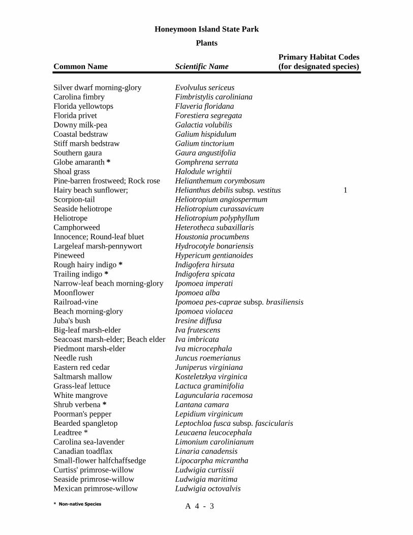
Honeymoon Island State Park
Plants Primary Habitat Codes Common Name Scientific Name (for designated species)
* Non-native Species A 4 - 3
Silver dwarf morning-glory Evolvulus sericeus Carolina fimbry Fimbristylis caroliniana Florida yellowtops Flaveria floridana Florida privet Forestiera segregata Downy milk-pea Galactia volubilis Coastal bedstraw Galium hispidulum Stiff marsh bedstraw Galium tinctorium Southern gaura Gaura angustifolia Globe amaranth * Gomphrena serrata Shoal grass Halodule wrightii Pine-barren frostweed; Rock rose Helianthemum corymbosum Hairy beach sunflower; Helianthus debilis subsp. vestitus 1 Scorpion-tail Heliotropium angiospermum Seaside heliotrope Heliotropium curassavicum Heliotrope Heliotropium polyphyllum Camphorweed Heterotheca subaxillaris Innocence; Round-leaf bluet Houstonia procumbens Largeleaf marsh-pennywort Hydrocotyle bonariensis Pineweed Hypericum gentianoides Rough hairy indigo * Indigofera hirsuta Trailing indigo * Indigofera spicata Narrow-leaf beach morning-glory Ipomoea imperati Moonflower Ipomoea alba Railroad-vine Ipomoea pes-caprae subsp. brasiliensis Beach morning-glory Ipomoea violacea Juba's bush Iresine diffusa Big-leaf marsh-elder Iva frutescens Seacoast marsh-elder; Beach elder Iva imbricata Piedmont marsh-elder Iva microcephala Needle rush Juncus roemerianus Eastern red cedar Juniperus virginiana Saltmarsh mallow Kosteletzkya virginica Grass-leaf lettuce Lactuca graminifolia White mangrove Laguncularia racemosa Shrub verbena * Lantana camara Poorman's pepper Lepidium virginicum Bearded spangletop Leptochloa fusca subsp. fascicularis Leadtree * Leucaena leucocephala Carolina sea-lavender Limonium carolinianum Canadian toadflax Linaria canadensis Small-flower halfchaffsedge Lipocarpha micrantha Curtiss' primrose-willow Ludwigia curtissii Seaside primrose-willow Ludwigia maritima Mexican primrose-willow Ludwigia octovalvis

Honeymoon Island State Park
Plants Primary Habitat Codes Common Name Scientific Name (for designated species)
* Non-native Species A 4 - 4
Sky-blue lupine Lupinus diffusus Christmasberry Lycium carolinianum Florida mayten Maytenus phyllanthoides Melaleuca, punk tree * Melaleuca quinquenervia Snow squarestem Melanthera nivea White sweet clover * Melilotus albus Creeping cucumber Melothria pendula Alamo vine * Merremia dissecta Climbing hempvine Mikania scandens Southern balsam-pear * Momordica charantia Horsemint Monarda punctata Hairgrass Muhlenbergia capillaris Wax myrtle Myrica cerifera Seaside evening-primrose Oenothera humifusa Cutleaf evening primrose Oenothera laciniata Clustered bluet Oldenlandia uniflora Prickly-pear cactus Opuntia humifusa Shell mound prickly-pear cactus Opuntia stricta 1, 5 Yellow wood-sorrel Oxalis corniculata Beachgrass Panicum amarum Fall panicum Panicum dichotomiflorum Switchgrass Panicum virgatum Virginia creeper Parthenocissus quinquefolia Florida paspalum Paspalum floridanum Thin paspalum Paspalum setaceum Vaseygrass * Paspalum urvillei Seashore paspalum Paspalum vaginatum Corky-stemmed passionflower Passiflora suberosa Spreading chinchweed Pectis prostrate Frog fruit; Carpetweed Phyla nodiflora Drummond's leaf-flower Phyllanthus abnormis Mascarene island leafflower * Phyllanthus tenellus Chamberbitter * Phyllanthus urniaria Coastal ground-cherry Physalis angustifolia Starry-hair ground-cherry Physalis walteri Pokeberry Phytolacca americana Slash pine Pinus elliottii Wing-stem camphorweed Pluchea carolinensis Shrubby camphorweed Pluchea odorata Wild poinsettia; painted-leaf Poinsettia cyathophora Showy milkwort Polygala grandiflora Rustweed Polypremum procumbens Paraguay purslane * Portulaca amilis Little hogweed * Portulaca oleracea

Honeymoon Island State Park
Plants Primary Habitat Codes Common Name Scientific Name (for designated species)
* Non-native Species A 4 - 5
Black cherry Prunus serotina Coastal blackroot; rabbit-tobacco Pterocaulon pycnostachyum Hairlike mock bishop's-weed Ptilimnium capillaceum Sand live oak Quercus geminata Turkey oak Quercus laevis Virginia live oak Quercus virginiana White indigo-berry Randia aculeata Red mangrove Rhizophora mangle Winged sumac Rhus copallina Red Natalgrass * Rhynchelytrum repens Michaux's snout-bean Rhynchosia michauxii White-tops; Star rush Rhynchospora colorata Tropical Mexican clover * Richardia brasiliensis Castorbean * Ricinis communis Bloodberry Rivina humilis Southern dewberry Rubus trivialis Hastate-leaf dock Rumex hastatulus Cabbage palm Sabal palmetto Perennial glasswort Sarcostemma perennis Carolina willow Salix caroliniana Water pimpernel Samolus ebracteatus Bowstring hemp * Sansevieria hyacinthoides Inkberry Scaevola plumieri 1 Brazilian pepper * Schinus terebinthifolius Sweetbroom Scoparia dulcis Saw palmetto Serenoa repens Bladderpod Sesbania vesicaria Shoreline sea purslane Sesuvium portulacastrum Knotroot foxtail Setaria parviflora Broomweed Sida acuta Llima * Sida cordifolia Saffron-plum Sideroxylon celastrinum Narrow-leaf blue-eyed grass Sisyrinchium angustifolium Ear-leaf greenbrier Smilax auriculata Saw greenbrier Smilax bona-nox American black nightshade Solanum americanum Black nightshade Solanum chenopodioides Tropical soda apple * Solanum viarum Seaside goldenrod Solidago sempervirens Wand goldenrod Solidago stricta Common sow thistle * Sonchus oleraceus Yellow necklace pod Sophora tomentosa var truncata Saltmarsh cordgrass Spartina alterniflora var. glabra Saltmeadow cordgrass Spartina patens
Honeymoon Island State Park
Plants Primary Habitat Codes Common Name Scientific Name (for designated species)
* Non-native Species A 4 - 6
Spring ladies'-tresses Spiranthes vernalis Smutgrass * Sporobolus indicus Seashore dropseed Sporobolus virginicus Diamond-flowers Stenaria nigricans St. Augustinegrass Stenotaphrum secundatum Queen's delight Stillingia sylvatica Sea blite Suaeda linearis Rice button aster Symphyotrichum dumosum Perennial saltmarsh aster Symphyotrichum tenuifolium Manateegrass Syringodium filiforme Scurf hoary-pea Tephrosia chrysophylla Turtlegrass Thalassia testudinum Small ball moss Tillandsia recurvata Spanish moss Tillandsia usneoides Eastern poison ivy Toxicodendron radicans Jamaician feverplant * Tribulus cistoides Forked bluecurls Trichostema dichotomum Purple sandgrass Triplasis purpurea Sea oats Uniola paniculata Paragrass * Uriochloa mutica Brazilian vervain * Verbena brasiliensis White crownbeard Verbesina virginica Piedmont cow-pea Vigna luteola Southern fox grape Vitis rotundifolia Spanish dagger Yucca aloifolia Hercules-club Zanthoxylum clava-herculis
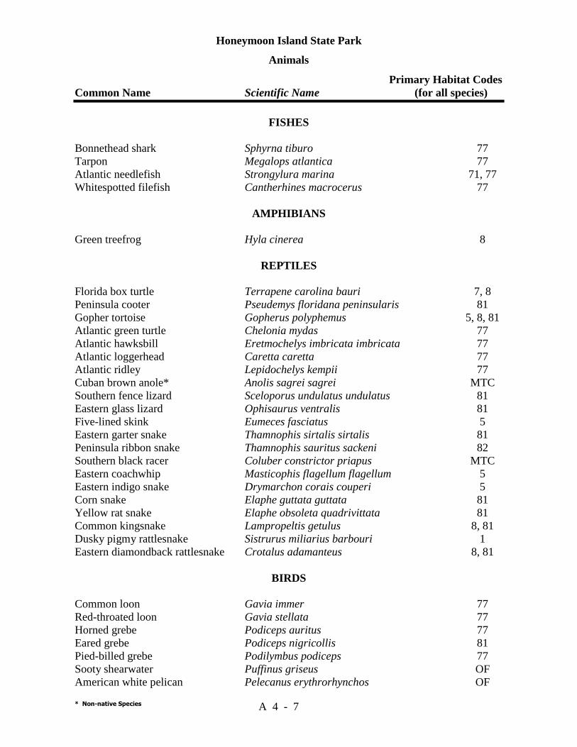
Honeymoon Island State Park
Animals Primary Habitat Codes Common Name Scientific Name (for all species)
* Non-native Species A 4 - 7
FISHES Bonnethead shark Sphyrna tiburo 77 Tarpon Megalops atlantica 77 Atlantic needlefish Strongylura marina 71, 77 Whitespotted filefish Cantherhines macrocerus 77
AMPHIBIANS Green treefrog Hyla cinerea 8
REPTILES Florida box turtle Terrapene carolina bauri 7, 8 Peninsula cooter Pseudemys floridana peninsularis 81 Gopher tortoise Gopherus polyphemus 5, 8, 81 Atlantic green turtle Chelonia mydas 77 Atlantic hawksbill Eretmochelys imbricata imbricata 77 Atlantic loggerhead Caretta caretta 77 Atlantic ridley Lepidochelys kempii 77 Cuban brown anole* Anolis sagrei sagrei MTC Southern fence lizard Sceloporus undulatus undulatus 81 Eastern glass lizard Ophisaurus ventralis 81 Five-lined skink Eumeces fasciatus 5 Eastern garter snake Thamnophis sirtalis sirtalis 81 Peninsula ribbon snake Thamnophis sauritus sackeni 82 Southern black racer Coluber constrictor priapus MTC Eastern coachwhip Masticophis flagellum flagellum 5 Eastern indigo snake Drymarchon corais couperi 5 Corn snake Elaphe guttata guttata 81 Yellow rat snake Elaphe obsoleta quadrivittata 81 Common kingsnake Lampropeltis getulus 8, 81 Dusky pigmy rattlesnake Sistrurus miliarius barbouri 1 Eastern diamondback rattlesnake Crotalus adamanteus 8, 81
BIRDS Common loon Gavia immer 77 Red-throated loon Gavia stellata 77 Horned grebe Podiceps auritus 77 Eared grebe Podiceps nigricollis 81 Pied-billed grebe Podilymbus podiceps 77 Sooty shearwater Puffinus griseus OF American white pelican Pelecanus erythrorhynchos OF

Honeymoon Island State Park
Animals Primary Habitat Codes Common Name Scientific Name (for all species)
* Non-native Species A 4 - 8
Eastern brown pelican Pelecanus occidentalis carolinensis OF, 77 Brown booby Sula leucogaster OF Northern gannet Sula bassanus OF Double-crested cormorant Phalacrocorax auritus OF Anhinga Anhinga anhinga OF Magnificent frigatebird Fregata magnificens OF Great blue heron Ardea herodias 1, 75 Green heron Butorides virescens 76 Cattle egret Bubulcus ibis OF, 81 Little blue heron Egretta caerulea 75 Reddish egret Egretta rufescens 77 Great egret Ardea alba 72, 75, 77 Snowy egret Egretta thula 77 Tricolored heron Egretta tricolor 77 Black-crowned night heron Nycticorax nycticorax 76 Yellow-crowned night heron Nyctanassa violacea 76 Least bittern Ixobrychus exilis 75 American bittern Botaurus lentiginosus 75 Wood stork Mycteria americana 81 White ibis Eudocimus albus 77 Roseate spoonbill Ajaia ajaja 77 Greater flamingo* Phoenicopterus ruber 77, OF Brant Branta bernicla 77 Snow goose Aen caerulescens 77 Mallard Anas platyrhynchos 81 Mottled duck Anas fulvigula 81 Gadwall Anas strepera 81 Northern pintail Anas acuta 81 Green-winged teal Anas crecca 81 Blue-winged teal Anas discors 81 American wigeon Anas americana 81 Northern shoveler Anas clypeata 81 Redhead Aythya americana 77 Ring-necked duck Aythya collaris 77 Canvasback Aythya valisineria 77 Greater scaup Aythya marila 77 Lesser scaup Aythya affinis 77 Bufflehead Bucephala albeola 77 Long-tailed duck Clangula hyemalis 77 Ruddy duck Oxyura jamaicensis 77 Hooded merganser Lophodytes cucullatus 77 Common merganser Mergus merganser 77 Red-breasted merganser Mergus serrator 77 Turkey vulture Cathartes aura OF

Honeymoon Island State Park
Animals Primary Habitat Codes Common Name Scientific Name (for all species)
* Non-native Species A 4 - 9
Black vulture Coragyps atratus OF Swallow-tailed kite Elanoides forficatus OF Mississippi kite Ictinia mississippiensis OF Sharp-shinned hawk Accipiter striatus OF Cooper's hawk Accipiter cooperii OF Red-tailed hawk Buteo jamaicensis OF Red-shouldered hawk Buteo lineatus 8, OF Broad-winged hawk Buteo platypterus OF Southern bald eagle Haliaeetus leucocephalus OF Northern harrier Circus cyaneus OF Osprey Pandion haliaetus 8, OF Peregrine falcon Falco peregrinus tundrius OF Merlin Falco columbarius OF American kestrel Falco sparverius OF Northern bobwhite Colinus virginianus 8 Wild turkey Meleagris gallopavo 8 Sandhill crane Grus canadensis OF King rail Rallus elegans 75 Florida clapper rail Rallus longirostris scottii 75 Virginia rail Rallus limicola 75 Sora Porzana carolina 81 Clapper rail Rallus longirostris 75 Purple gallinule Porphyrula martinica 81 Common moorhen Gallinula chloropus 81 American coot Fulica americana 77 American oystercatcher Haematopus palliatus 77 Semipalmated plover Charadrius semipalmatus 77 Piping plover Charadrius melodus 77 Southeastern snowy plover Charadrius alexandrinus tenuirostris 77 Wilson's plover Charadrius wilsonia 77 Killdeer Charadrius vociferus 77 Black-bellied plover Pluvialis squatarola 77 Ruddy turnstone Arenaria interpres 77 Common snipe Gallinago gallinago 75 Long-billed curlew Numenius americanus 77 Whimbrel Numenius phaeopus 77 Spotted sandpiper Actitis macularia 77 Solitary sandpiper Tringa solitaria 77 Greater yellowlegs Tringa melanoleuca 77 Lesser yellowlegs Tringa flavipes 77 Willet Catoptrophorus semipalmatus 77 Red knot Calidris canutus 77 Pectoral sandpiper Calidris melanotos 77 White-rumped sandpiper Calidris fuscicollis 77
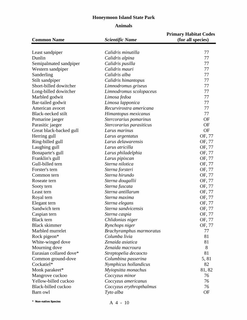
Honeymoon Island State Park
Animals Primary Habitat Codes Common Name Scientific Name (for all species)
* Non-native Species A 4 - 10
Least sandpiper Calidris minutilla 77 Dunlin Calidris alpina 77 Semipalmated sandpiper Calidris pusilla 77 Western sandpiper Calidris mauri 77 Sanderling Calidris alba 77 Stilt sandpiper Calidris himantopus 77 Short-billed dowitcher Limnodromus griseus 77 Long-billed dowitcher Limnodromus scolopaceus 77 Marbled godwit Limosa fedoa 77 Bar-tailed godwit Limosa lapponica 77 American avocet Recurvirostra americana 77 Black-necked stilt Himantopus mexicanus 77 Pomarine jaeger Stercorarius pomarinus OF Parasitic jaeger Stercorarius parasiticus OF Great black-backed gull Larus marinus OF Herring gull Larus argentatus OF, 77 Ring-billed gull Larus delawarensis OF, 77 Laughing gull Larus atricilla OF, 77 Bonaparte's gull Larus philadelphia OF, 77 Franklin's gull Larus pipixcan OF, 77 Gull-billed tern Sterna nilotica OF, 77 Forster's tern Sterna forsteri OF, 77 Common tern Sterna hirundo OF, 77 Roseate tern Sterna dougallii OF, 77 Sooty tern Sterna fuscata OF, 77 Least tern Sterna antillarum OF, 77 Royal tern Sterna maxima OF, 77 Elegant tern Sterna elegans OF, 77 Sandwich tern Sterna sandvicensis OF, 77 Caspian tern Sterna caspia OF, 77 Black tern Chlidonias niger OF, 77 Black skimmer Rynchops niger OF, 77 Marbled murrelet Brachyramphus marmoratus 77 Rock pigeon* Columba livia 81 White-winged dove Zenaida asiatica 81 Mourning dove Zenaida macroura 8 Eurasian collared dove* Streptopelia decaocto 81 Common ground-dove Columbina passerina 5, 81 Cockatiel* Nymphicus hollandicus 82 Monk parakeet* Myiopsitta monachus 81, 82 Mangrove cuckoo Coccyzus minor 76 Yellow-billed cuckoo Coccyzus americanus 76 Black-billed cuckoo Coccyzus erythropthalmus 76 Barn owl Tyto alba OF
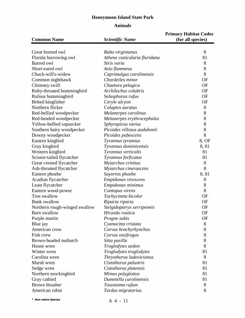
Honeymoon Island State Park
Animals Primary Habitat Codes Common Name Scientific Name (for all species)
* Non-native Species A 4 - 11
Great horned owl Bubo virginianus 8 Florida burrowing owl Athene cunicularia floridana 81 Barred owl Strix varia 8 Short-eared owl Asio flammeus 8 Chuck-will's-widow Caprimulgus carolinensis 8 Common nighthawk Chordeiles minor OF Chimney swift Chaetura pelagica OF Ruby-throated hummingbird Archilochus colubris OF Rufous hummingbird Selasphorus rufus OF Belted kingfisher Ceryle alcyon OF Northern flicker Colaptes auratus 8 Red-bellied woodpecker Melanerpes carolinus 8 Red-headed woodpecker Melanerpes erythrocephalus 8 Yellow-bellied sapsucker Sphyrapicus varius 8 Southern hairy woodpecker Picoides villosus audubonii 8 Downy woodpecker Picoides pubescens 8 Eastern kingbird Tyrannus tyrannus 8, OF Gray kingbird Tyrannus dominicensis 8, 81 Western kingbird Tyrannus verticalis 81 Scissor-tailed flycatcher Tyrannus forficatus 81 Great crested flycatcher Myiarchus crinitus 8 Ash-throated flycatcher Myiarchus cinerascens 8 Eastern phoebe Sayornis phoebe 8, 81 Acadian flycatcher Empidonax virescens 8 Least flycatcher Empidonax minimus 8 Eastern wood-pewee Contopus virens 8 Tree swallow Tachycineta bicolor OF Bank swallow Riparia riparia OF Northern rough-winged swallow Stelgidopteryx serripennis OF Barn swallow Hirundo rustica OF Purple martin Progne subis OF Blue jay Cyanocitta cristata 8 American crow Corvus brachyrhynchos 8 Fish crow Corvus ossifragus 8 Brown-headed nuthatch Sitta pusilla 8 House wren Troglodytes aedon 8 Winter wren Troglodytes troglodytes 81 Carolina wren Thryothorus ludovicianus 8 Marsh wren Cistothorus palustris 81 Sedge wren Cistothorus platensis 81 Northern mockingbird Mimus polyglottos 81 Gray catbird Dumetella carolinensis 81 Brown thrasher Toxostoma rufum 8 American robin Turdus migratorius 8
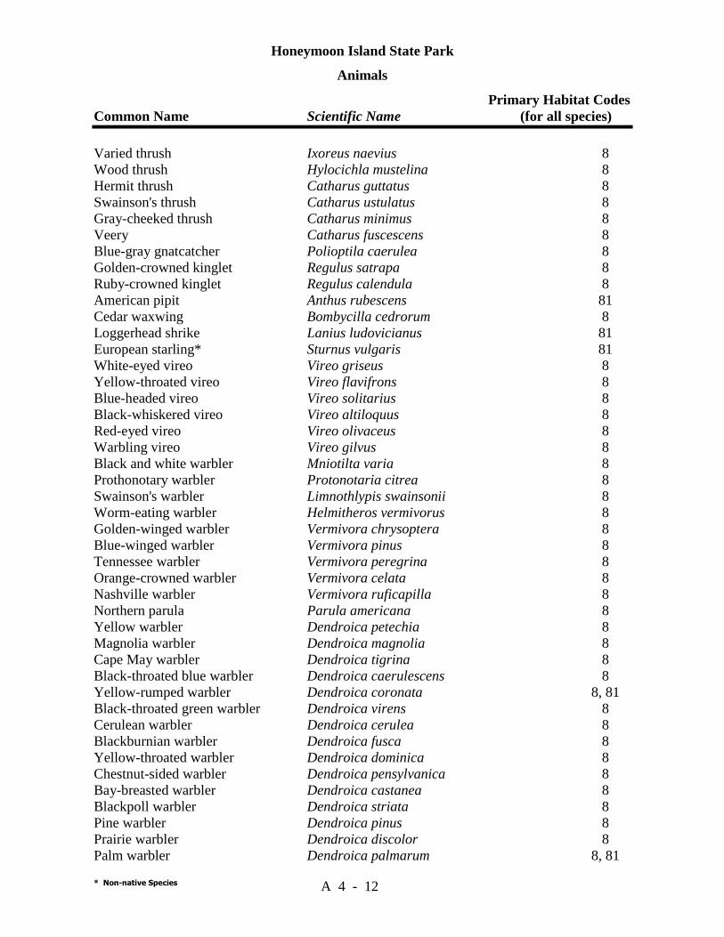
Honeymoon Island State Park
Animals Primary Habitat Codes Common Name Scientific Name (for all species)
* Non-native Species A 4 - 12
Varied thrush Ixoreus naevius 8 Wood thrush Hylocichla mustelina 8 Hermit thrush Catharus guttatus 8 Swainson's thrush Catharus ustulatus 8 Gray-cheeked thrush Catharus minimus 8 Veery Catharus fuscescens 8 Blue-gray gnatcatcher Polioptila caerulea 8 Golden-crowned kinglet Regulus satrapa 8 Ruby-crowned kinglet Regulus calendula 8 American pipit Anthus rubescens 81 Cedar waxwing Bombycilla cedrorum 8 Loggerhead shrike Lanius ludovicianus 81 European starling* Sturnus vulgaris 81 White-eyed vireo Vireo griseus 8 Yellow-throated vireo Vireo flavifrons 8 Blue-headed vireo Vireo solitarius 8 Black-whiskered vireo Vireo altiloquus 8 Red-eyed vireo Vireo olivaceus 8 Warbling vireo Vireo gilvus 8 Black and white warbler Mniotilta varia 8 Prothonotary warbler Protonotaria citrea 8 Swainson's warbler Limnothlypis swainsonii 8 Worm-eating warbler Helmitheros vermivorus 8 Golden-winged warbler Vermivora chrysoptera 8 Blue-winged warbler Vermivora pinus 8 Tennessee warbler Vermivora peregrina 8 Orange-crowned warbler Vermivora celata 8 Nashville warbler Vermivora ruficapilla 8 Northern parula Parula americana 8 Yellow warbler Dendroica petechia 8 Magnolia warbler Dendroica magnolia 8 Cape May warbler Dendroica tigrina 8 Black-throated blue warbler Dendroica caerulescens 8 Yellow-rumped warbler Dendroica coronata 8, 81 Black-throated green warbler Dendroica virens 8 Cerulean warbler Dendroica cerulea 8 Blackburnian warbler Dendroica fusca 8 Yellow-throated warbler Dendroica dominica 8 Chestnut-sided warbler Dendroica pensylvanica 8 Bay-breasted warbler Dendroica castanea 8 Blackpoll warbler Dendroica striata 8 Pine warbler Dendroica pinus 8 Prairie warbler Dendroica discolor 8 Palm warbler Dendroica palmarum 8, 81
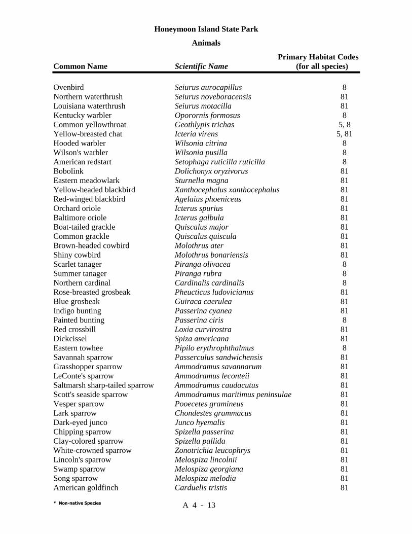
Honeymoon Island State Park
Animals Primary Habitat Codes Common Name Scientific Name (for all species)
* Non-native Species A 4 - 13
Ovenbird Seiurus aurocapillus 8 Northern waterthrush Seiurus noveboracensis 81 Louisiana waterthrush Seiurus motacilla 81 Kentucky warbler Oporornis formosus 8 Common yellowthroat Geothlypis trichas 5, 8 Yellow-breasted chat Icteria virens 5, 81 Hooded warbler Wilsonia citrina 8 Wilson's warbler Wilsonia pusilla 8 American redstart Setophaga ruticilla ruticilla 8 Bobolink Dolichonyx oryzivorus 81 Eastern meadowlark Sturnella magna 81 Yellow-headed blackbird Xanthocephalus xanthocephalus 81 Red-winged blackbird Agelaius phoeniceus 81 Orchard oriole Icterus spurius 81 Baltimore oriole Icterus galbula 81 Boat-tailed grackle Quiscalus major 81 Common grackle Quiscalus quiscula 81 Brown-headed cowbird Molothrus ater 81 Shiny cowbird Molothrus bonariensis 81 Scarlet tanager Piranga olivacea 8 Summer tanager Piranga rubra 8 Northern cardinal Cardinalis cardinalis 8 Rose-breasted grosbeak Pheucticus ludovicianus 81 Blue grosbeak Guiraca caerulea 81 Indigo bunting Passerina cyanea 81 Painted bunting Passerina ciris 8 Red crossbill Loxia curvirostra 81 Dickcissel Spiza americana 81 Eastern towhee Pipilo erythrophthalmus 8 Savannah sparrow Passerculus sandwichensis 81 Grasshopper sparrow Ammodramus savannarum 81 LeConte's sparrow Ammodramus leconteii 81 Saltmarsh sharp-tailed sparrow Ammodramus caudacutus 81 Scott's seaside sparrow Ammodramus maritimus peninsulae 81 Vesper sparrow Pooecetes gramineus 81 Lark sparrow Chondestes grammacus 81 Dark-eyed junco Junco hyemalis 81 Chipping sparrow Spizella passerina 81 Clay-colored sparrow Spizella pallida 81 White-crowned sparrow Zonotrichia leucophrys 81 Lincoln's sparrow Melospiza lincolnii 81 Swamp sparrow Melospiza georgiana 81 Song sparrow Melospiza melodia 81 American goldfinch Carduelis tristis 81
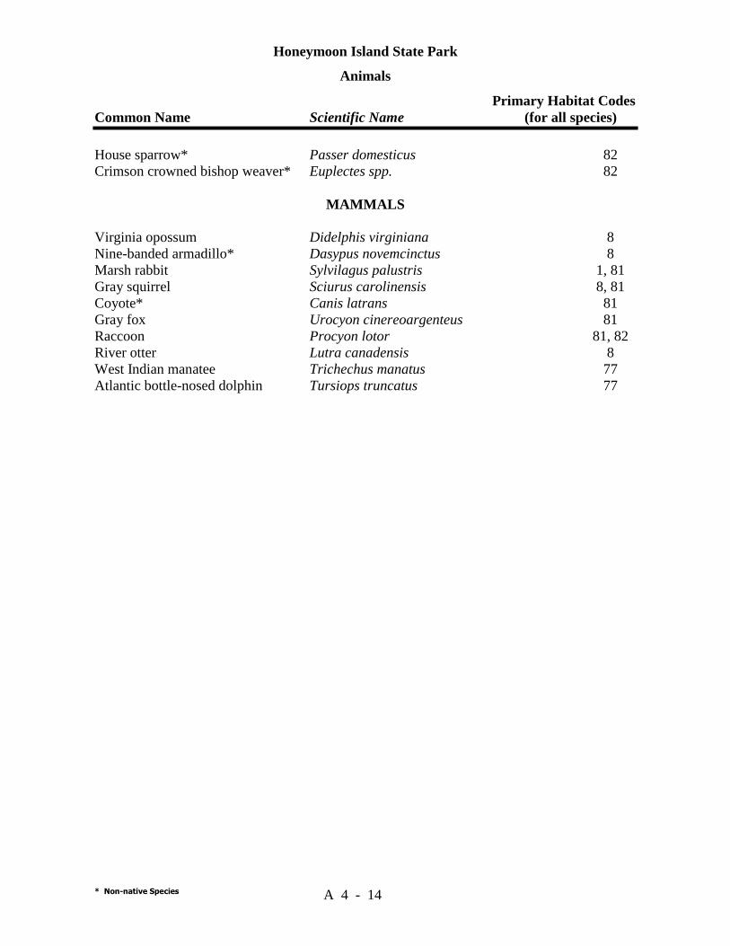
Honeymoon Island State Park
Animals Primary Habitat Codes Common Name Scientific Name (for all species)
* Non-native Species A 4 - 14
House sparrow* Passer domesticus 82 Crimson crowned bishop weaver* Euplectes spp. 82
MAMMALS Virginia opossum Didelphis virginiana 8 Nine-banded armadillo* Dasypus novemcinctus 8 Marsh rabbit Sylvilagus palustris 1, 81 Gray squirrel Sciurus carolinensis 8, 81 Coyote* Canis latrans 81 Gray fox Urocyon cinereoargenteus 81 Raccoon Procyon lotor 81, 82 River otter Lutra canadensis 8 West Indian manatee Trichechus manatus 77 Atlantic bottle-nosed dolphin Tursiops truncatus 77
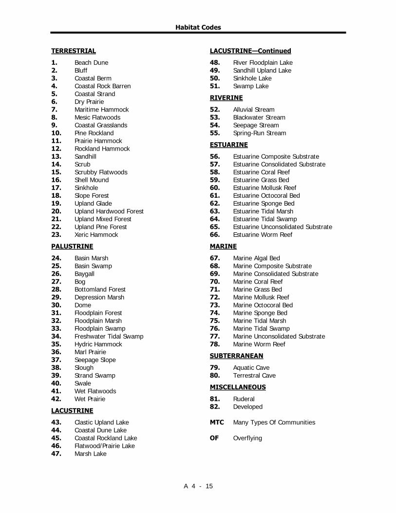
Habitat Codes
A 4 - 15
TERRESTRIAL 1. Beach Dune 2. Bluff 3. Coastal Berm 4. Coastal Rock Barren 5. Coastal Strand 6. Dry Prairie 7. Maritime Hammock 8. Mesic Flatwoods 9. Coastal Grasslands 10. Pine Rockland 11. Prairie Hammock 12. Rockland Hammock 13. Sandhill 14. Scrub 15. Scrubby Flatwoods 16. Shell Mound 17. Sinkhole 18. Slope Forest 19. Upland Glade 20. Upland Hardwood Forest 21. Upland Mixed Forest 22. Upland Pine Forest 23. Xeric Hammock PALUSTRINE 24. Basin Marsh 25. Basin Swamp 26. Baygall 27. Bog 28. Bottomland Forest 29. Depression Marsh 30. Dome 31. Floodplain Forest 32. Floodplain Marsh 33. Floodplain Swamp 34. Freshwater Tidal Swamp 35. Hydric Hammock 36. Marl Prairie 37. Seepage Slope 38. Slough 39. Strand Swamp 40. Swale 41. Wet Flatwoods 42. Wet Prairie LACUSTRINE 43. Clastic Upland Lake 44. Coastal Dune Lake 45. Coastal Rockland Lake 46. Flatwood/Prairie Lake 47. Marsh Lake
LACUSTRINE—Continued 48. River Floodplain Lake 49. Sandhill Upland Lake 50. Sinkhole Lake 51. Swamp Lake RIVERINE 52. Alluvial Stream 53. Blackwater Stream 54. Seepage Stream 55. Spring-Run Stream ESTUARINE 56. Estuarine Composite Substrate 57. Estuarine Consolidated Substrate 58. Estuarine Coral Reef 59. Estuarine Grass Bed 60. Estuarine Mollusk Reef 61. Estuarine Octocoral Bed 62. Estuarine Sponge Bed 63. Estuarine Tidal Marsh 64. Estuarine Tidal Swamp 65. Estuarine Unconsolidated Substrate 66. Estuarine Worm Reef MARINE 67. Marine Algal Bed 68. Marine Composite Substrate 69. Marine Consolidated Substrate 70. Marine Coral Reef 71. Marine Grass Bed 72. Marine Mollusk Reef 73. Marine Octocoral Bed 74. Marine Sponge Bed 75. Marine Tidal Marsh 76. Marine Tidal Swamp 77. Marine Unconsolidated Substrate 78. Marine Worm Reef SUBTERRANEAN 79. Aquatic Cave 80. Terrestral Cave MISCELLANEOUS 81. Ruderal 82. Developed MTC Many Types Of Communities OF Overflying

Habitat Codes
A 4 - 16

Addendum 5—Designated Species List


Rank Explanations For FNAI Global Rank, FNAI State Rank,
Federal Status And State Status
A 5 - 1
The Nature Conservancy and the Natural Heritage Program Network (of which FNAI is a part) define an element as any exemplary or rare component of the natural environment,such as a species,natural community,bird rookery,spring,sinkhole,cave,or other ecological feature. An element occurrence (EO) is a single extant habitat that sustains or otherwise contributes to the survival of a population or a distinct,self-sustaining example of a particular element. Using a ranking system developed by The Nature Conservancy and the Natural Heritage Program Network,the Florida Natural Areas Inventory assigns two ranks to each element. The global rank is based on an element's worldwide status; the state rank is based on the status of the element in Florida. Element ranks are based on many factors,the most important ones being estimated number of Element occurrences,estimated abundance (number of individuals for species; area for natural communities),range,estimated adequately protected EOs,relative threat of destruction,and ecological fragility. Federal and State status information is from the U.S. Fish and Wildlife Service; and the Florida Game and Freshwater Fish Commission (animals),and the Florida Department of Agriculture and Consumer Services (plants),respectively.
FNAI GLOBAL RANK DEFINITIONS G1 = Critically imperiled globally because of extreme rarity (5 or fewer occurrences or less than 1000
individuals) or because of extreme vulnerability to extinction due to some natural or man-made factor.
G2 = Imperiled globally because of rarity (6 to 20 occurrences or less than 3000 individuals) or because of vulnerability to extinction due to some natural or man-made factor.
G3 = Either very rare and local throughout its range (21-100 occurrences or less than 10,000 individuals) or found locally in a restricted range or vulnerable to extinction of other factors.
G4 = apparently secure globally (may be rare in parts of range) G5 = demonstrably secure globally GH = of historical occurrence throughout its range,may be rediscovered (e.g.,ivory-billed
woodpecker) GX = believed to be extinct throughout range GXC = extirpated from the wild but still known from captivity or cultivation G#? = tentative rank (e.g.,G2?) G#G# = range of rank; insufficient data to assign specific global rank (e.g.,G2G3) G#T# = rank of a taxonomic subgroup such as a subspecies or variety; the G portion of the rank refers
to the entire species and the T portion refers to the specific subgroup; numbers have same definition as above (e.g.,G3T1)
G#Q = rank of questionable species - ranked as species but questionable whether it is species or subspecies; numbers have same definition as above (e.g.,G2Q)
G#T#Q = same as above,but validity as subspecies or variety is questioned. GU = due to lack of information,no rank or range can be assigned (e.g.,GUT2). G? = not yet ranked (temporary) S1 = Critically imperiled in Florida because of extreme rarity (5 or fewer occurrences or less than
1000 individuals) or because of extreme vulnerability to extinction due to some natural or man-made factor.
S2 = Imperiled in Florida because of rarity (6 to 20 occurrences or less than 3000 individuals) or because of vulnerability to extinction due to some natural or man-made factor.
S3 = Either very rare and local throughout its range (21-100 occurrences or less than 10,000 individuals) or found locally in a restricted range or vulnerable to extinction of other factors.
S4 = apparently secure in Florida (may be rare in parts of range) S5 = demonstrably secure in Florida SH = of historical occurrence throughout its range,may be rediscovered (e.g.,ivory-billed
woodpecker) SX = believed to be extinct throughout range SA = accidental in Florida,i.e.,not part of the established biota SE = an exotic species established in Florida may be native elsewhere in North America SN = regularly occurring,but widely and unreliably distributed; sites for conservation hard to
determine SU = due to lack of information,no rank or range can be assigned (e.g.,SUT2). S? = not yet ranked (temporary)

Rank Explanations For FNAI Global Rank, FNAI State Rank,
Federal Status And State Status
A 5 - 2
LEGAL STATUS N = Not currently listed,nor currently being considered for listing,by state or federal agencies. FEDERAL (Listed by the U. S. Fish and Wildlife Service - USFWS) LE = Listed as Endangered Species in the List of Endangered and Threatened Wildlife and Plants
under the provisions of the Endangered Species Act. Defined as any species that is in danger of extinction throughout all or a significant portion of its range.
PE = Proposed for addition to the List of Endangered and Threatened Wildlife and Plants as Endangered Species.
LT = Listed as Threatened Species. Defined as any species that is likely to become an endangered species within the near future throughout all or a significant portion of its range.
PT = Proposed for listing as Threatened Species. C = Candidate Species for addition to the list of Endangered and Threatened Wildlife and Plants.
Defined as those species for which the USFWS currently has on file sufficient information on biological vulnerability and threats to support proposing to list the species as endangered or threatened.
E(S/A) = Endangered due to similarity of appearance. T(S/A) = Threatened due to similarity of appearance. STATE Animals (Listed by the Florida Fish and Wildlife Conservation Commission - FFWCC) LE = Listed as Endangered Species by the FFWCC. Defined as a species,subspecies,or isolated
population which is so rare or depleted in number or so restricted in range of habitat due to any man-made or natural factors that it is in immediate danger of extinction or extirpation from the state,or which may attain such a status within the immediate future.
LT = Listed as Threatened Species by the FFWCC. Defined as a species,subspecies,or isolated population which is acutely vulnerable to environmental alteration,declining in number at a rapid rate,or whose range or habitat is decreasing in area at a rapid rate and as a consequence is destined or very likely to become an endangered species within the foreseeable future.
LS = Listed as Species of Special Concern by the FFWCC. Defined as a population which warrants special protection,recognition,or consideration because it has an inherent significant vulnerability to habitat modification,environmental alteration,human disturbance,or substantial human exploitation which,in the foreseeable future,may result in its becoming a threatened species.
Plants (Listed by the Florida Department of Agriculture and Consumer Services - FDACS) LE = Listed as Endangered Plants in the Preservation of Native Flora of Florida Act. Defined as
species of plants native to the state that are in imminent danger of extinction within the state,the survival of which is unlikely if the causes of a decline in the number of plants continue,and includes all species determined to be endangered or threatened pursuant to the Federal Endangered Species Act of 1973,as amended.
LT = Listed as Threatened Plants in the Preservation of Native Flora of Florida Act. Defined as species native to the state that are in rapid decline in the number of plants within the state,but which have not so decreased in such number as to cause them to be endangered.

Honeymoon Island State Park
Designated Species
Plants Common Name/ Designated Species Status Scientific Name FDA USFWS FNAI
A 5 - 3
Tampa butterfly orchid Encyclia tampensis CE Hairy beach sunflower Helianthus debilis subsp. vestitus MC G5T2,S2 Shell Mound prickly-pear cactus Opuntia stricta LT Inkberry Scaevola plumieri LT
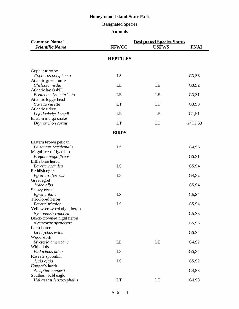
Honeymoon Island State Park Designated Species
Animals Common Name/ Designated Species Status Scientific Name FFWCC USFWS FNAI
A 5 - 4
REPTILES Gopher tortoise Gopherus polyphemus LS G3,S3 Atlantic green turtle Chelonia mydas LE LE G3,S2 Atlantic hawksbill Eretmochelys imbricata LE LE G3,S1 Atlantic loggerhead Caretta caretta LT LT G3,S3 Atlantic ridley Lepidochelys kempii LE LE G1,S1 Eastern indigo snake Drymarchon corais LT LT G4T3,S3
BIRDS Eastern brown pelican Pelecanus occidentalis LS G4,S3 Magnificent frigatebird Fregata magnificens G5,S1 Little blue heron Egretta caerulea LS G5,S4 Reddish egret Egretta rufescens LS G4,S2 Great egret Ardea alba G5,S4 Snowy egret Egretta thula LS G5,S4 Tricolored heron Egretta tricolor LS G5,S4 Yellow-crowned night heron Nyctanassa violacea G5,S3 Black-crowned night heron Nycticorax nycticorax G5,S3 Least bittern Ixobrychus exilis G5,S4 Wood stork Mycteria americana LE LE G4,S2 White ibis Eudocimus albus LS G5,S4 Roseate spoonbill Ajaia ajaja LS G5,S2 Cooper’s hawk Accipiter cooperii G4,S3 Southern bald eagle Haliaeetus leucocephalus LT LT G4,S3
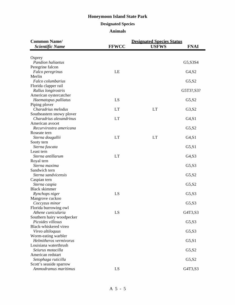
Honeymoon Island State Park Designated Species
Animals Common Name/ Designated Species Status Scientific Name FFWCC USFWS FNAI
A 5 - 5
Osprey Pandion haliaetus G5,S3S4 Peregrine falcon Falco peregrinus LE G4,S2 Merlin Falco columbarius G5,S2 Florida clapper rail Rallus longirostris G5T3?,S3? American oystercatcher Haematopus palliatus LS G5,S2 Piping plover Charadrius melodus LT LT G3,S2 Southeastern snowy plover Charadrius alexandrinus LT G4,S1 American avocet Recurvirostra americana G5,S2 Roseate tern Sterna dougallii LT LT G4,S1 Sooty tern Sterna fuscata G5,S1 Least tern Sterna antillarum LT G4,S3 Royal tern Sterna maxima G5,S3 Sandwich tern Sterna sandvicensis G5,S2 Caspian tern Sterna caspia G5,S2 Black skimmer Rynchops niger LS G5,S3 Mangrove cuckoo Coccyzus minor G5,S3 Florida burrowing owl Athene cunicularia LS G4T3,S3 Southern hairy woodpecker Picoides villosus G5,S3 Black-whiskered vireo Vireo altiloquus G5,S3 Worm-eating warbler Helmitheros vermivorus G5,S1 Louisiana waterthrush Seiurus motacilla G5,S2 American redstart Setophaga ruticilla G5,S2 Scott’s seaside sparrow Ammodramus maritimus LS G4T3,S3

Honeymoon Island State Park Designated Species
Animals Common Name/ Designated Species Status Scientific Name FFWCC USFWS FNAI
A 5 - 6
MAMMALS
West Indian manatee Trichechus manatus latirostris LE LE G2,S2

Addendum 6—Priority Schedule And Cost Estimates

Honeymoon Island State Park Priority Schedule And Cost Estimates
A 6 - 1
Estimates are developed for the funding and staff resources needed to implement the management plan based on goals, objectives and priority management activities. Funding priorities for all state park management and development activities are reviewed each year as part of the Division’s legislative budget process. The Division prepares an annual legislative budget request based on the priorities established for the entire state park system. The Division also aggressively pursues a wide range of other funds and staffing resources, such as grants, volunteers, and partnerships with agencies, local governments and the private sector for supplementing normal legislative appropriations to address unmet needs. The ability of the Division to implement the specific goals, objectives and priority actions identified in this plan will be determined by the availability of funding resources for these purposes. Resource Management A. Exotic plant removal, completed over ten years. Estimated Cost: Contracted cost, including manpower, herbicide, and travel is
$1500/ac for removal of Brazilian pepper in an island situation. There are approximately 40 acres requiring Brazilian pepper removal. Removal of cogongrass, St. Augustine grass, and other exotics will be an ongoing project with annual costs estimated at $3000.00, including 200 manhours/yr, and $1000.00/yr for herbicides and application equipment and supplies.
Subtotal: $150,000 for ten years. B. Maintenance of natural communities and restoration of ruderal sites. Estimated Cost: There are 11 burn zones at Honeymoon Island. Allowing a day and 4
park rangers to burn each zone, and burning half of the zones twice and the remainder at least once in 5 years, results in a manpower cost of $10,000.00 over ten years. Equipment and supplies are estimated at $2000.00/yr, and training will cost another $1600.00/yr. An additional $1800.00/yr ($1000.00 for supplies, including plants; $800/yr manpower costs) is allowed for revegetation of ruderal sites.
Subtotal: $60,000 for 10 years. C. Protection of shorebird nesting and wintering habitat by managing public access
through signs and barriers, education, interpretation, and law enforcement. Monitor nesting. years.
Estimated Cost: During nesting season, a park ranger should patrol the site daily

Honeymoon Island State Park Priority Schedule And Cost Estimates
A 6 - 2
during weekends and holidays, and sporadically during the week. Allowing 4 hours during the week and 4 hours on weekends, at $10.00/hr the cost is $80.00/wk. Materials for signs, barriers and educational displays are estimated to cost $2,000.00/yr. The presence of a law enforcement officer may be required once per month. The cost for this is $15.00/hr for 3 hrs/mo, plus $120.00/mo for fuel, totaling $1980.00/yr.
Subtotal: $81,4,00 for 10 years. D. Protect and monitor seagrass beds around the park. Estimated Cost: Law enforcement may be required to deal with violations of the
seagrass bed protection zone. Allowing one patrol per weekend (3 hrs) would cost $2340.00/yr manpower and $3120.00/yr fuel. Monitoring seagrass beds is very inexpensive. Posting additional seagrass bed sites would cost $200.00/sign. Twenty additional signs are allowed for over 10 years.
Subtotal: $58,600 for ten years. E. Monitor sea turtle nesting, osprey nesting, and wading birds. Estimated Cost: A park ranger will need to survey the beach daily during sea turtle
nesting season (May-Sept). Osprey nesting can be monitored weekly. At $10.00/hr, and 16 hrs/wk, the annual cost (22 weeks) is $3520.00. Nest screening supplies for raccoon deterrence, will cost $500.00/yr.
Subtotal: $40,200 for ten years. TOTAL ESTIMATED COST: $390,000.00

Honeymoon Island State Park Priority Schedule And Cost Estimates
A 6 - 3
Capital Improvements
Development Area or Facilities Cost Caladesi Island Land Base ..................................................................................200,000.00 Interpretive Improvements .....................................................................................1,875.00 Maintenance Area ................................................................................................499,875.00 Nature Center..........................................................................................................65,000.00 Reconfiguration of Parking Lot ..........................................................................710,000.00 Trail Development..............................................................................................$230,000.00 Total w/contingency.......................................................................................$2,171,100.00

Honeymoon Island State Park Priority Schedule And Cost Estimates
A 6 - 4

Additional Information
FNAI Descriptions
DHR Cultural Management Statement
And
Land Management Review Report

Descriptions Of Natural Communities Developed By FNAI
1
This summary presents the hierarchical classification and brief descriptions of 82 Natural Communities developed by Florida Natural Areas Inventory and identified as collectively constituting the original, natural biological associations of Florida.
A Natural Community is defined as a distinct and recurring assemblage of populations of plants, animals, fungi and microorganisms naturally associated with each other and their physical environment. For more complete descriptions, see Guide to the Natural Communities of Florida, available from Florida Department of Natural Resources.
The levels of the hierarchy are:
Natural Community Category - defined by hydrology and vegetation.
Natural Community Groups - defined by landform, substrate, and vegetation.
Natural Community Type - defined by landform and substrate; soil moisture condition; climate; fire; and characteristic vegetation.
TERRESTRIAL COMMUNITIES
XERIC UPLANDS COASTAL UPLANDS
MESIC UPLANDS ROCKLANDS
MESIC FLATLANDS
PALUSTRINE COMMUNITIES
WET FLATLANDS SEEPAGE WETLANDS
FLOODPLAIN WETLANDS BASIN WETLANDS
LACUSTRINE COMMUNITIES
RIVERINE COMMUNITIES
SUBTERRANEAN COMMUNITIES
MARINE/ESTUARINE COMMUNITIES
Definitions of Terms Used in Natural Community Descriptions
TERRESTRIAL - Upland habitats dominated by plants which are not adapted to anaerobic soil conditions imposed by saturation or inundation for more than 10% of the growing season.
XERIC UPLANDS - very dry, deep, well-drained hills of sand with xeric-adapted vegetation.
Sandhill - upland with deep sand substrate; xeric; temperate; frequent fire (2-5 years); longleaf pine and/or turkey oak with wiregrass understory.
Scrub - old dune with deep fine sand substrate; xeric; temperate or subtropical; occasional or rare fire (20 - 80 years); sand pine and/or scrub oaks and/or rosemary and lichens.
Xeric Hammock - upland with deep sand substrate; xeric-mesic; temperate or subtropical; rare or no fire; live oak and/or sand live oak and/or laurel oak and/or other oaks, sparkleberry, saw palmetto.
COASTAL UPLANDS - substrate and vegetation influenced primarily by such coastal (maritime) processes as erosion, deposition, salt spray, and storms.
Beach Dune - active coastal dune with sand substrate; xeric; temperate or subtropical; occasional or rare fire; sea oats and/or mixed salt-spray tolerant grasses and herbs.
Coastal Berm - old bar or storm debris with sand/shell substrate; xeric-mesic; subtropical or temperate; rare or no fire; buttonwood, mangroves, and/or mixed halophytic herbs and/or shrubs and trees.

Descriptions Of Natural Communities Developed By FNAI
2
Coastal Grassland - coastal flatland with sand substrate; xeric-mesic; subtropical or temperate; occasional fire; grasses, herbs, and shrubs with or without slash pine and/or cabbage palm.
Coastal Rock Barren - flatland with exposed limestone substrate; xeric; subtropical; no fire; algae, mixed halophytic herbs and grasses, and/or cacti and stunted shrubs and trees.
Coastal Strand - stabilized coastal dune with sand substrate; xeric; subtropical or temperate; occasional or rare fire; dense saw palmetto and/or seagrape and/or mixed stunted shrubs, yucca, and cacti.
Maritime Hammock - stabilized coastal dune with sand substrate; xeric-mesic; subtropical or temperate; rare or no fire; mixed hardwoods and/or live oak.
Shell Mound - Indian midden with shell substrate; xeric-mesic; subtropical or temperate; rare or no fire; mixed hardwoods.
MESIC UPLANDS - dry to moist hills of sand with varying amounts of clay, silt or organic material; diverse mixture of broadleaved and needleleaved temperate woody species.
Bluff - steep slope with rock, sand, and/or clay substrate; hydric-xeric; temperate; sparse grasses, herbs and shrubs.
Slope Forest - steep slope on bluff or in sheltered ravine; sand/clay substrate; mesic-hydric; temperate; rare or no fire; magnolia, beech, spruce pine, Shumard oak, Florida maple, mixed hardwoods.
Upland Glade - upland with calcareous rock and/or clay substrate; hydric-xeric; temperate; sparse mixed grasses and herbs with occasional stunted trees and shrubs, e.g., eastern red cedar.
Upland Hardwood Forest - upland with sand/clay and/or calcareous substrate; mesic; temperate; rare or no fire; spruce pine, magnolia, beech, pignut hickory, white oak, and mixed hardwoods.
Upland Mixed Forest - upland with sand/clay substrate; mesic; temperate; rare or no fire; loblolly pine and/or shortleaf pine and/or laurel oak and/or magnolia and spruce pine and/or mixed hardwoods.
Upland Pine Forest - upland with sand/clay substrate; mesic-xeric; temperate; frequent or occasional fire; longleaf pine and/or loblolly pine and/or shortleaf pine, southern red oak, wiregrass.
ROCKLANDS - low, generally flat limestone outcrops with tropical vegetation; or limestone exposed through karst activities with tropical or temperate vegetation.
Pine Rockland - flatland with exposed limestone substrate; mesic-xeric; subtropical; frequent fire; south Florida slash pine, palms and/or hardwoods, and mixed grasses and herbs.
Rockland Hammock - flatland with limestone substrate; mesic; subtropical; rare or no fire; mixed tropical hardwoods, often with live oak.
Sinkhole - karst feature with steep limestone walls; mesic-hydric; subtropical or temperate; no fire; ferns, herbs, shrubs, and hardwoods.
MESIC FLATLANDS - flat, moderately well-drained sandy substrates with admixture of organic material, often with a hard pan.
Dry Prairie - flatland with sand substrate; mesic-xeric; subtropical or temperate; annual or frequent fire; wiregrass, saw palmetto, and mixed grasses and herbs.

Descriptions Of Natural Communities Developed By FNAI
3
Mesic Flatwoods - flatland with sand substrate; mesic; subtropical or temperate; frequent fire; slash pine and/or longleaf pine with saw palmetto, gallberry and/or wiregrass or cutthroat grass understory.
Prairie Hammock - flatland with sand/organic soil over marl or limestone substrate; mesic; subtropical; occasional or rare fire; live oak and/or cabbage palm.
Scrubby Flatwoods - flatland with sand substrate; xeric-mesic; subtropical or temperate; occasional fire; longleaf pine or slash pine with scrub oaks and wiregrass understory.
PALUSTRINE - Wetlands dominated by plants adapted to anaerobic substrate conditions imposed by substrate saturation or inundation during 10% or more of the growing season. Includes non-tidal wetlands; tidal wetlands with ocean derived salinities less than 0.5 ppt and dominance by salt-intolerant species; small (less than 8 ha), shallow (less than 2 m deep at low water) water bodies without wave-formed or bedrock shoreline; and inland brackish or saline wetlands.
WET FLATLANDS - flat, poorly drained sand, marl or limestone substrates.
Hydric Hammock - lowland with sand/clay/organic soil, often over limestone; mesic-hydric; subtropical or temperate; rare or no fire; water oak, cabbage palm, red cedar, red maple, bays, hackberry, hornbeam, blackgum, needle palm, and mixed hardwoods.
Marl Prairie - flatland with marl over limestone substrate; seasonally inundated; tropical; frequent to no fire; sawgrass, spikerush, and/or mixed grasses, sometimes with dwarf cypress.
Wet Flatwoods - flatland with sand substrate; seasonally inundated; subtropical or temperate; frequent fire; vegetation characterized by slash pine or pond pine and/or cabbage palm with mixed grasses and herbs.
Wet Prairie - flatland with sand substrate; seasonally inundated; subtropical or temperate; annual or frequent fire; maidencane, beakrush, spikerush, wiregrass, pitcher plants, St. John's wort, mixed herbs.
SEEPAGE WETLANDS - sloped or flat sands or peat with high moisture levels maintained by downslope seepage; wetland and mesic woody and/or herbaceous vegetation.
Baygall - wetland with peat substrate at base of slope; maintained by downslope seepage, usually saturated and occasionally inundated; subtropical or temperate; rare or no fire; bays and/or dahoon holly and/or red maple and/or mixed hardwoods.
Seepage Slope - wetland on or at base of slope with organic/sand substrate; maintained by downslope seepage, usually saturated but rarely inundated; subtropical or temperate; frequent or occasional fire; sphagnum moss, mixed grasses and herbs or mixed hydrophytic shrubs.
FLOODPLAIN WETLANDS - flat, alluvial sand or peat substrates associated with flowing water courses and subjected to flooding but not permanent inundation; wetland or mesic woody and herbaceous vegetation.
Bottomland Forest - flatland with sand/clay/organic substrate; occasionally inundated; temperate; rare or no fire; water oak, red maple, beech, magnolia, tuliptree, sweetgum, bays, cabbage palm, and mixed hardwoods.
Floodplain Forest - floodplain with alluvial substrate of sand, silt, clay or organic soil; seasonally inundated; temperate; rare or no fire; diamondleaf oak, overcup oak, water oak, swamp chestnut oak, blue palmetto, cane, and mixed hardwoods.
Floodplain Marsh - floodplain with organic/sand/alluvial substrate; seasonally inundated;
Descriptions Of Natural Communities Developed By FNAI
4
subtropical; frequent or occasional fire; maidencane, pickerelweed, sagittaria spp., buttonbush, and mixed emergents.
Floodplain Swamp - floodplain with organic/alluvial substrate; usually inundated; subtropical or temperate; rare or no fire; vegetation characterized by cypress, tupelo, black gum, and/or pop ash.
Freshwater Tidal Swamp - river mouth wetland, organic soil with extensive root mat; inundated with freshwater in response to tidal cycles; rare or no fire; cypress, bays, cabbage palm, gums and/or cedars.
Slough - broad, shallow channel with peat over mineral substrate; seasonally inundated, flowing water; subtropical; occasional or rare fire; pop ash and/or pond apple or water lily.
Strand Swamp - broad, shallow channel with peat over mineral substrate; seasonally inundated, flowing water; subtropical; occasional or rare fire; cypress and/or willow.
Swale - broad, shallow channel with sand/peat substrate; seasonally inundated, flowing water; subtropical or temperate; frequent or occasional fire; sawgrass, maidencane, pickerelweed, and/or mixed emergents.
BASIN WETLANDS - shallow, closed basin with outlet usually only in time of high water; peat or sand substrate, usually inundated; wetland woody and/or herbaceous vegetation.
Basin Marsh - large basin with peat substrate; seasonally inundated; temperate or subtropical; frequent fire; sawgrass and/or cattail and/or buttonbush and/or mixed emergents.
Basin Swamp - large basin with peat substrate; seasonally inundated, still water; subtropical or temperate; occasional or rare fire; vegetation characterized by cypress, blackgum, bays and/or mixed hardwoods.
Bog - wetland on deep peat substrate; moisture held by sphagnum mosses, soil usually saturated, occasionally inundated; subtropical or temperate; rare fire; sphagnum moss and titi and/or bays and/or dahoon holly, and/or mixed hydrophytic shrubs.
Coastal Interdunal Swale - long narrow depression wetlands in sand/peat-sand substrate; seasonally inundated, fresh to brackish, still water; temperate; rare fire; graminoids and mixed wetland forbs.
Depression Marsh - small rounded depression in sand substrate with peat accumulating toward center; seasonally inundated, still water; subtropical or temperate; frequent or occasional fire; maidencane, fire flag, pickerelweed, and mixed emergents, may be in concentric bands.
Dome Swamp - rounded depression in sand/limestone substrate with peat accumulating toward center; seasonally inundated, still water; subtropical or temperate; occasional or rare fire; cypress, blackgum, or bays, often tallest in center.
LACUSTRINE - Non-flowing wetlands of natural depressions lacking persistent emergent vegetation except around the perimeter.
Clastic Upland Lake - generally irregular basin in clay uplands; predominantly with inflows, frequently without surface outflow; clay or organic substrate; colored, acidic, soft water with low mineral content (sodium, chloride, sulfate); oligo-mesotrophic to eutrophic.
Coastal Dune Lake - basin or lagoon influenced by recent coastal processes; predominantly sand substrate with some organic matter; salinity variable among and within lakes, and subject to saltwater intrusion and storm surges; slightly acidic, hard water with high mineral content (sodium, chloride).
Descriptions Of Natural Communities Developed By FNAI
5
Coastal Rockland Lake - shallow basin influence by recent coastal processes; predominantly barren oolitic or Miami limestone substrate; salinity variable among and within lakes, and subject to saltwater intrusion, storm surges and evaporation (because of shallowness); slightly alkaline, hard water with high mineral content (sodium, chloride).
Flatwoods/Prairie Lake - generally shallow basin in flatlands with high water table; frequently with a broad littoral zone; still water or flow-through; sand or peat substrate; variable water chemistry, but characteristically colored to clear, acidic to slightly alkaline, soft to moderately hard water with moderate mineral content (sodium, chloride, sulfate); oligo-mesotrophic to eutrophic.
Marsh lake - generally shallow, open water area within wide expanses of freshwater marsh; still water or flow-through; peat, sand or clay substrate; occurs in most physiographic regions; variable water chemistry, but characteristically highly colored, acidic, soft water with moderate mineral content (sodium, chloride, sulfate); oligo-mesotrophic to eutrophic.
River Floodplain Lake - meander scar, backwater, or larger flow-through body within major river floodplains; sand, alluvial or organic substrate; colored, alkaline or slightly acidic, hard or moderately hard water with high mineral content (sulfate, sodium, chloride, calcium, magnesium); mesotrophic to eutrophic.
Sandhill Upland Lake - generally rounded solution depression in deep sandy uplands or sandy uplands shallowly underlain by limestone; predominantly without surface inflows/outflows; typically sand substrate with organic accumulations toward middle; clear, acidic moderately soft water with varying mineral content; ultra-oligotrophic to mesotrophic.
Sinkhole Lake - typically deep, funnel-shaped depression in limestone base; occurs in most physiographic regions; predominantly without surface inflows/outflows, but frequently with connection to the aquifer; clear, alkaline, hard water with high mineral content (calcium, bicarbonate, magnesium).
Swamp Lake - generally shallow, open water area within basin swamps; still water or flow-through; peat, sand or clay substrate; occurs in most physiographic regions; variable water chemistry, but characteristically highly colored, acidic, soft water with moderate mineral content (sodium, chloride, sulfate); oligo-mesotrophic to eutrophic.
RIVERINE - Natural, flowing waters from their source to the downstream limits of tidal influence and bounded by channel banks.
Alluvial Stream - lower perennial or intermittent/seasonal watercourse characterized by turbid water with suspended silt, clay, sand and small gravel; generally with a distinct, sediment-derived (alluvial) floodplain and a sandy, elevated natural levee just inland from the bank.
Blackwater Stream - perennial or intermittent/seasonal watercourse characterized by tea-colored water with a high content of particulate and dissolved organic matter derived from drainage through swamps and marshes; generally lacking an alluvial floodplain.
Seepage Stream - upper perennial or intermittent/seasonal watercourse characterized by clear to lightly colored water derived from shallow groundwater seepage.
Spring-run Stream - perennial watercourse with deep aquifer headwaters and characterized by clear water, circumneutral pH and, frequently, a solid limestone bottom.
SUBTERRANEAN - Twilight, middle and deep zones of natural chambers overlain by the earth's crust and characterized by climatic stability and assemblages of trogloxenic, troglophilic, and troglobitic
Descriptions Of Natural Communities Developed By FNAI
6
organisms.
Aquatic Cave - cavernicolous area permanently or periodically submerged; often characterized by troglobitic crustaceans and salamanders; includes high energy systems which receive large quantities of organic detritus and low energy systems.
Terrestrial Cave - cavernicolous area lacking standing water; often characterized by bats, such as Myotis spp., and other terrestrial vertebrates and invertebrates; includes interstitial areas above standing water such as fissures in the ceiling of caves.
MARINE/ESTUARINE (The distinction between the Marine and Estuarine Natural Communities is often subtle, and the natural communities types found under these two community categories have the same descriptions. For these reasons they have been grouped together.) - Subtidal, intertidal and supratidal zones of the sea, landward to the point at which seawater becomes significantly diluted with freshwater inflow from the land.
Consolidated Substrate - expansive subtidal, intertidal and supratidal area composed primarily of nonliving compacted or coherent and relatively hard, naturally formed mass of mineral matter (e.g., coquina limerock and relic reefs); octocorals, sponges, stony corals, nondrift macrophytic algae, blue-green mat-forming algae and seagrasses sparse, if present.
Unconsolidated Substrate - expansive subtidal, intertidal and supratidal area composed primarily of loose mineral matter (e.g., coralgal, gravel, marl, mud, sand and shell); octocorals, sponges, stony corals, nondrift macrophytic algae, blue-green mat-forming algae and seagrasses sparse, if present.
Octocoral Bed - expansive subtidal area occupied primarily by living sessile organisms of the Class Anthozoa, Subclass Octocorallia (e.g., soft corals, horny corals, sea fans, sea whips, and sea pens); sponges, stony corals, nondrift macrophytic algae and seagrasses spares, if present.
Sponge Bed - expansive subtidal area occupied primarily by living sessile organisms of the Phylum Porifera (e.g., sheepswool sponge, Florida loggerhead sponge and branching candle sponge); octocorals, stony corals, nondrift macrophytic algae and seagrasses sparse, if present.
Coral Reef - expansive subtidal area with elevational gradient or relief and occupied primarily by living sessile organisms of the Class Hydrozoa (e.g., fire corals and hydrocorals) and Class Anthozoa, Subclass Zoantharia (e.g., stony corals and black corals); includes deepwater bank reefs, fringing barrier reefs, outer bank reefs and patch reefs, some of which may contain distinct zones of assorted macrophytes, octocorals, & sponges.
Mollusk Reef - substantial subtidal or intertidal area with relief from concentrations of sessile organisms of the Phylum Mollusca, Class Bivalvia (e.g., molluscs, oysters, & worm shells); octocorals, sponges, stony corals, macrophytic algae and seagrasses sparse, if present.
Worm Reef - substantial subtidal or intertidal area with relief from concentrations of sessile, tubicolous organisms of the Phylum Annelida, Class Polychaeta (e.g., chaetopterids and sabellarids); octocorals, sponges, stony corals, macrophytic algae and seagrasses sparse, if present.
Algal Bed - expansive subtidal, intertidal or supratidal area, occupied primarily by attached thallophytic or mat-forming prokaryotic algae (e.g, halimeda, blue-green algae); octocorals, sponges, stony corals and seagrasses sparse, if present.
Grass Bed - expansive subtidal or intertidal area, occupied primarily by rooted vascular macrophytes, (e.g., shoal grass, halophila, widgeon grass, manatee grass and turtle grass); may include various epiphytes and epifauna; octocorals, sponges, stony corals, and attached macrophytic algae sparse, if present.

Descriptions Of Natural Communities Developed By FNAI
7
Composite Substrate - expansive subtidal, intertidal, or supratidal area, occupied primarily by Natural Community elements from more than one Natural Community category (e.g., Grass Bed and Algal Bed species; Octocoral and Algal Bed species); includes both patchy and evenly distributed occurrences.
Tidal Marsh - expansive intertidal or supratidal area occupied primarily by rooted, emergent vascular macrophytes (e.g., cord grass, needlerush, saw grass, saltwort, saltgrass and glasswort); may include various epiphytes and epifauna.
Tidal Swamp - expansive intertidal and supratidal area occupied primarily by woody vascular macrophytes (e.g., black mangrove, buttonwood, red mangrove, and white mangrove); may include various epiphytes and epifauna.
DEFINITIONS OF TERMS Terrestrial and Palustrine Natural Communities
Physiography Upland - high area in region with significant topographic relief; generally undulating Lowland - low area in region with or without significant topographic relief; generally flat to gently sloping Flatland - generally level area in region without significant topographic relief; flat to gently sloping Basin - large, relatively level lowland with slopes confined to the perimeter or isolated interior locations Depression - small depression with sloping sides, deepest in center and progressively shallower towards the perimeter Floodplain - lowland adjacent to a stream; topography influenced by recent fluvial processes Bottomland - lowland not on active floodplain; sand/clay/organic substrate
Hydrology occasionally inundated - surface water present only after heavy rains and/or during flood stages seasonally inundated - surface water present during wet season and flood periods usually inundated - surface water present except during droughts
Climatic Affinity of the Flora tropical - community generally occurs in practically frost-free areas subtropical - community generally occurs in areas that experience occasional frost, but where freezing temperatures are not frequent enough to cause true winter dormancy temperate - community generally occurs in areas that freeze often enough that vegetation goes into winter dormancy
Fire annual fire - burns about every 1-2 years frequent fire - burns about every 3-7 years occasional fire - burns about every 8-25 years rare fire - burns about every 26-100 years no fire - community develops only when site goes more than 100 years without burning
Descriptions Of Natural Communities Developed By FNAI
8
LATIN NAMES OF PLANTS MENTIONED IN NATURAL COMMUNITY DESCRIPTIONS anise - Illicium floridanum bays: swamp bay -Persea palustris gordonia -Gordonia lasianthus sweetbay -Magnolia virgiana beakrush - Rhynchospora spp. beech - Fagus grandifolia blackgum - Nyssa biflora blue palmetto - Sabal minor bluestem - Andropogon spp. buttonbush - Cephalanthus occidentalis cabbage palm - Sabal palmetto cacti - Opuntia and Harrisia spp., predominantly stricta and pentagonus cane - Arundinaria gigantea or A. tecta cattail - Typha spp. cedars: red cedar - Juniperus silicicola white cedar - Chamaecyparis thyoides or C. henryi cladonia - Cladonia spp. cypress - Taxodium distichum dahoon holly - Ilex cassine diamondleaf oak - Quercus laurifolia fire flag - Thalia geniculata Florida maple - Acer barbatum gallberry - Ilex glabra gums: tupelo - Nyssa aquatica blackgum - Nyssa biflora Ogeechee gum - Nyssa ogeche hackberry - Celtis laevigata hornbeam - Carpinus caroliniana laurel oak - Quercus hemisphaerica live oak - Quercus virginiana loblolly pine - Pinus taeda longleaf pine - Pinus palustris magnolia - Magnolia grandiflora maidencane - Panicum hemitomon needle palm - Rhapidophyllum hystrix
overcup oak - Quercus lyrata pickerel weed - Pontederia cordata or P. lanceolata pignut hickory - Carya glabra pop ash - Fraxinus caroliniana pond apple - Annona glabra pond pine - Pinus serotina pyramid magnolia - Magnolia pyramidata railroad vine - Ipomoea pes-caprae red cedar - Juniperus silicicola red maple - Acer rubrum red oak - Quercus falcata rosemary - Ceratiola ericoides sagittaria - Sagittaria lancifolia sand pine - Pinus clausa saw palmetto - Serenoa repens sawgrass - Cladium jamaicensis scrub oaks - Quercus geminata, Q. chapmanii, Q. myrtifolia,Q. inopina sea oats - Uniola paniculata seagrape - Coccoloba uvifera shortleaf pine - Pinus echinata Shumard oak - Quercus shumardii slash pine - Pinus elliottii sphagnum moss - Sphagnum spp. spikerush - Eleocharis spp. spruce pine - Pinus glabra St. John's wort - Hypericum spp. swamp chestnut oak - Quercus prinus sweetgum - Liquidambar styraciflua titi - Cyrilla racemiflora, and Cliftonia monophylla tuliptree - Liriodendron tulipfera tupelo - Nyssa aquatica turkey oak - Quercus laevis water oak - Quercus nigra waterlily - Nymphaea odorata white cedar - Chamaecyparis thyoides white oak - Quercus alba willow - Salix caroliniana yucca - Yucca aloifolia
Management Procedures For Archaeological And Historical Sites And Properties
On State -- Owned Or Controlled Lands (Revised August, 1995)
9
A. GENERAL DISCUSSION Archaeological and historic sites are defined collectively in 267.021(3), F.S., as "historic properties" or "historic resources." They have several essential characteristics that must be recognized in a management program. First of all, they are a finite and non-renewable resource. Once destroyed, presently existing resources, including buildings, other structures, shipwreck remains, archaeological sites and other objects of antiquity, cannot be renewed or revived. Today, sites in the State of Florida are being destroyed by all kinds of land development, inappropriate land management practices, erosion, looting, and to a minor extent even by well-intentioned professional scientific research (e.g., archaeological excavation). Measures must be taken to ensure that some of these resources will be preserved for future study and appreciation. Secondly, sites are unique because individually they represent the tangible remains of events that occurred at a specific time and place. Thirdly, while sites uniquely reflect localized events, these events and the origin of particular sites are related to conditions and events in other times and places. Sites can be understood properly only in relation to their natural surroundings and the activities of inhabitants of other sites. Managers must be aware of this "systemic" character of historic and archaeological sites. Also, it should be recognized that archaeological sites are time capsules for more than cultural history; they preserve traces of past biotic communities, climate, and other elements of the environment that may be of interest to other scientific disciplines. Finally, the significance of sites, particularly archaeological ones, derives not only from the individual artifacts within them, but equally from the spatial arrangement of those artifacts in both horizontal and vertical planes. When archaeologists excavate, they recover, not merely objects, but also a record of the positions of these objects in relation to one another and their containing matrix (e.g., soil strata). Much information is sacrificed if the so-called "context" of archaeological objects is destroyed or not recovered, and this is what archaeologists are most concerned about when a site is threatened with destruction or damage. The artifacts themselves can be recovered even after a site is heavily disturbed, but the context -- the vertical and horizontal relationships -- cannot. Historic structures also contain a wealth of cultural (socio-economic) data that can be lost if historically sensitive maintenance, restoration or rehabilitation procedures are not implemented, or if they are demolished or extensively altered without appropriate documentation. Lastly, it should not be forgotten that historic structures often have associated potentially significant historic archaeological features that must be considered in land management decisions. B. STATUTORY AUTHORITY Chapter 253, Florida Statutes ("State Lands") directs the preparation of "single-use" or "multiple-use" land management plans for all state-owned lands and state-owned sovereignty submerged lands. In this document, 253.034(4), F.S., specifically requires that "all management plans, whether for single-use or multiple-use properties, shall specifically describe how the managing agency plans to identify, locate, protect and preserve, or otherwise use fragile non-renewable resources, such as archaeological and historic sites, as well as other fragile resources..." Chapter 267, Florida Statutes is the primary historic preservation authority of the state. The importance of protecting and interpreting archaeological and historic sites is recognized in 267.061(1)(a), F.S.:The rich and unique heritage of historic properties in this state, representing more than 10,000 years of human presence, is an important legacy to be valued and conserved for present and future generations. The destruction of these nonrenewable historic resources will engender a significant loss to the state's quality of life, economy, and cultural environment. It is therefore declared to be state policy to:
Management Procedures For Archaeological And Historical Sites And Properties
On State -- Owned Or Controlled Lands (Revised August, 1995)
10
1. Provide leadership in the preservation of the state's historic resources; [and] 2. Administer state-owned or state-controlled historic resources in a spirit of stewardship and
trusteeship;... Responsibilities of the Division of Historical Resources in the Department of State pursuant to 267.061(3), F.S., include the following: 1. Cooperate with federal and state agencies, local Governments, and private organizations and
individuals to direct and conduct a comprehensive statewide survey of historic resources and to maintain an inventory of such responses.
2. Develop a comprehensive statewide historic preservation plan. 3. Identify and nominate eligible properties to the National Register of Historic Places and otherwise
administer applications for listing properties in the National Register of Historic Places. 4. Cooperate with federal and state agencies, local governments, and organizations and individuals
to ensure that historic resources are taken into consideration at all levels of planning and development.
5. Advise and assist, as appropriate, federal and state agencies and local governments in carrying out their historic preservation responsibilities and programs.
6. Carry out on behalf of the state the programs of the National Historic Preservation Act of 1966, as amended, and to establish, maintain, and administer a state historic preservation program meeting the requirements of an approved program and fulfilling the responsibilities of state historic preservation programs as provided in subsection 101(b) of that act.
7. Take such other actions necessary or appropriate to locate, acquire, protect, preserve, operate, interpret, and promote the location, acquisition, protection, preservation, operation, and interpretation of historic resources to foster an appreciation of Florida history and culture. Prior to the acquisition, preservation, interpretation, or operation of a historic property by a state agency, the Division shall be provided a reasonable opportunity to review and comment on the proposed undertaking and shall determine that there exists historic authenticity and a feasible means of providing for the preservation, interpretation and operation of such property.
8. Establish professional standards for the preservation, exclusive of acquisition, of historic resources in state ownership or control.
9. Establish guidelines for state agency responsibilities under subsection (2). Responsibilities of other state agencies of the executive branch, pursuant to 267.061(2), F.S., include: 1. Each state agency of the executive branch having direct or indirect jurisdiction over a proposed
state or state-assisted undertaking shall, in accordance with state policy and prior to the approval of expenditure of any state funds on the undertaking, consider the effect of the undertaking on any historic property that is included in, or eligible for inclusion in, the National Register of Historic Places. Each such agency shall afford the division a reasonable opportunity to comment with regard to such an undertaking.
2. Each state agency of the executive branch shall initiate measures in consultation with the division to assure that where, as a result of state action or assistance carried out by such agency, a historic property is to be demolished or substantially altered in a way that adversely affects the character, form, integrity, or other qualities that contribute to [the] historical, architectural, or archaeological value of the property, timely steps are taken to determine that no feasible and prudent alternative to the proposed demolition or alteration exists, and, where no such alternative is determined to exist, to assure that timely steps are taken either to avoid or mitigate the adverse effects, or to undertake an appropriate archaeological salvage excavation or other recovery action to document the property as it existed prior to demolition or alteration.
3. In consultation with the division [of Historical Resources], each state agency of the executive branch shall establish a program to locate, inventory, and evaluate all historic properties under the agency's ownership or control that appear to qualify for the National Register. Each such agency shall exercise caution to assure that any such historic property is not inadvertently
Management Procedures For Archaeological And Historical Sites And Properties
On State -- Owned Or Controlled Lands (Revised August, 1995)
11
transferred, sold, demolished, substantially altered, or allowed to deteriorate significantly. 4. Each state agency of the executive branch shall assume responsibility for the preservation of
historic resources that are owned or controlled by such agency. Prior to acquiring, constructing, or leasing buildings for the purpose of carrying out agency responsibilities, the agency shall use, to the maximum extent feasible, historic properties available to the agency. Each agency shall undertake, consistent with preservation of such properties, the mission of the agency, and the professional standards established pursuant to paragraph (3)(k), any preservation actions necessary to carry out the intent of this paragraph.
5. Each state agency of the executive branch, in seeking to acquire additional space through new construction or lease, shall give preference to the acquisition or use of historic properties when such acquisition or use is determined to be feasible and prudent compared with available alternatives. The acquisition or use of historic properties is considered feasible and prudent if the cost of purchase or lease, the cost of rehabilitation, remodeling, or altering the building to meet compliance standards and the agency's needs, and the projected costs of maintaining the building and providing utilities and other services is less than or equal to the same costs for available alternatives. The agency shall request the division to assist in determining if the acquisition or use of a historic property is feasible and prudent. Within 60 days after making a determination that additional space is needed, the agency shall request the division to assist in identifying buildings within the appropriate geographic area that are historic properties suitable for acquisition or lease by the agency, whether or not such properties are in need of repair, alteration, or addition.
6. Consistent with the agency's mission and authority, all state agencies of the executive branch shall carry out agency programs and projects, including those under which any state assistance is provided, in a manner which is generally sensitive to the preservation of historic properties and shall give consideration to programs and projects which will further the purposes of this section.
Section 267.12 authorizes the Division to establish procedures for the granting of research permits for archaeological and historic site survey or excavation on state-owned or controlled lands, while Section 267.13 establishes penalties for the conduct of such work without first obtaining written permission from the Division of Historical Resources. The Rules of the Department of State, Division of Historical Resources, for research permits for archaeological sites of significance are contained in Chapter 1A-32, F.A.C. Another Florida Statute affecting land management decisions is Chapter 872, F.S. Section 872.02, F.S., pertains to marked grave sites, regardless of age. Many state-owned properties contain old family and other cemeteries with tombstones, crypts, etc. Section 872.05, F.S., pertains to unmarked human burial sites, including prehistoric and historic Indian burial sites. Unauthorized disturbance of both marked and unmarked human burial site is a felony. C. MANAGEMENT POLICY The choice of a management policy for archaeological and historic sites within state-owned or controlled land obviously depends upon a detailed evaluation of the characteristics and conditions of the individual sites and groups of sites within those tracts. This includes an interpretation of the significance (or potential significance) of these sites, in terms of social and political factors, as well as environmental factors. Furthermore, for historic structures architectural significance must be considered, as well as any associated historic landscapes. Sites on privately owned lands are especially vulnerable to destruction, since often times the economic incentives for preservation are low compared to other uses of the land areas involved. Hence, sites in public ownership have a magnified importance, since they are the ones with the best chance of survival over the long run. This is particularly true of sites that are state-owned or controlled, where the basis of management is to provide for land uses that are minimally destructive of resource values.

Management Procedures For Archaeological And Historical Sites And Properties
On State -- Owned Or Controlled Lands (Revised August, 1995)
12
It should be noted that while many archaeological and historical sites are already recorded within state--owned or controlled--lands, the majority of the uplands areas and nearly all of the inundated areas have not been surveyed to locate and assess the significance of such resources. The known sites are, thus, only an incomplete sample of the actual resources - i.e., the number, density, distribution, age, character and condition of archaeological and historic sites - on these tracts. Unfortunately, the lack of specific knowledge of the actual resources prevents formulation of any sort of detailed management or use plan involving decisions about the relative historic value of individual sites. For this reason, a generalized policy of conservation is recommended until the resources have been better addressed. The generalized management policy recommended by the Division of Historical Resources includes the following: 1. State land managers shall coordinate all planned activities involving known archaeological or
historic sites or potential site areas closely with the Division of Historical Resources in order to prevent any kind of disturbance to significant archaeological or historic sites that may exist on the tract. Under 267.061(1)(b), F.S., the Division of Historical Resources is vested with title to archaeological and historic resources abandoned on state lands and is responsible for administration and protection of such resources. The Division will cooperate with the land manager in the management of these resources. Furthermore, provisions of 267.061(2) and 267.13, F.S., combined with those in 267.061(3) and 253.034(4), F.S., require that other managing (or permitting) agencies coordinate their plans with the Division of Historical Resources at a sufficiently early stage to preclude inadvertent damage or destruction to known or potentially occurring, presently unknown archaeological and historic sites. The provisions pertaining to human burial sites must also be followed by state land managers when such remains are known or suspected to be present (see 872.02 and 872.05, F.S., and 1A-44, F.A.C.)
2. Since the actual resources are so poorly known, the potential impact of the managing agency's activities on historic archaeological sites may not be immediately apparent. Special field survey for such sites may be required to identify the potential endangerment as a result of particular management or permitting activities. The Division may perform surveys, as its resources permit, to aid the planning of other state agencies in their management activities, but outside archaeological consultants may have to be retained by the managing agency. This would be especially necessary in the cases of activities contemplating ground disturbance over large areas and unexpected occurrences. It should be noted, however, that in most instances Division staff's knowledge of known and expected site distribution is such that actual field surveys may not be necessary, and the project may be reviewed by submitting a project location map (preferably a 7.5 minute U.S.G.S. Quadrangle map or portion thereof) and project descriptive data, including detailed construction plans. To avoid delays, Division staff should be contacted to discuss specific project documentation review needs.
3. In the case of known significant sites, which may be affected by proposed project activities, the managing agency will generally be expected to alter proposed management or development plans, as necessary, or else make special provisions to minimize or mitigate damage to such sites.
4. If in the course of management activities, or as a result of development or the permitting of dredge activities (see 403.918(2)(6)a, F.S.), it is determined that valuable historic or archaeological sites will be damaged or destroyed, the Division reserves the right, pursuant to 267.061(1)(b), F.S., to require salvage measures to mitigate the destructive impact of such activities to such sites. Such salvage measures would be accomplished before the Division would grant permission for destruction of the affected site areas. The funding needed to implement salvage measures would be the responsibility of the managing agency planning the site destructive activity. Mitigation of historic structures at a minimum involves the preparation of measured drawings and documentary photographs. Mitigation of archaeological resources involves the excavation, analysis and reporting of the project findings and must be planned to

Management Procedures For Archaeological And Historical Sites And Properties
On State -- Owned Or Controlled Lands (Revised August, 1995)
13
occur sufficiently in advance to avoid project construction delays. If these services are to be contracted by the state agency, the selected consultant will need to obtain an Archaeological Research Permit from the Division of Historical Resources, Bureau of Archaeological Research (see 267.12, F.S. and Rules 1A-32 and 1A-46 F.A.C.).
5. For the near future, excavation of non-endangered (i.e., sites not being lost to erosion or development) archaeological site is discouraged. There are many endangered sites in Florida (on both private and public lands) in need of excavation because of the threat of development or other factors. Those within state-owned or controlled lands should be left undisturbed for the present - with particular attention devoted to preventing site looting by "treasure hunters". On the other hand, the archaeological and historic survey of these tracts is encouraged in order to build an inventory of the resources present, and to assess their scientific research potential and historic or architectural significance.
6. The cooperation of land managers in reporting sites to the Division that their field personnel may discover is encouraged. The Division will help inform field personnel from other resource managing agencies about the characteristics and appearance of sites. The Division has initiated a cultural resource management training program to help accomplish this. Upon request the Division will also provide to other agencies archaeological and historical summaries of the known and potentially occurring resources so that information may be incorporated into management plans and public awareness programs (See Management Implementation).
7. Any discovery of instances of looting or unauthorized destruction of sites must be reported to the agent for the Board of Trustees of the Internal Improvement Trust Fund and the Division so that appropriate action may be initiated. When human burial sites are involved, the provisions of 872.02 and 872.05, F. S. and Rule 1A-44, F.A.C., as applicable, must also be followed. Any state agent with law enforcement authority observing individuals or groups clearly and incontrovertibly vandalizing, looting or destroying archaeological or historic sites within state-owned or controlled lands without demonstrable permission from the Division will make arrests and detain those individuals or groups under the provisions of 267.13, 901.15, and 901.21, F.S., and related statutory authority pertaining to such illegal activities on state-owned or controlled lands. County Sheriffs' officers are urged to assist in efforts to stop and/or prevent site looting and destruction.
In addition to the above management policy for archaeological and historic sites on state-owned land, special attention shall be given to those properties listed in the National Register of Historic Places and other significant buildings. The Division recommends that the Secretary of the Interior's Standards for Rehabilitation and Guidelines for Rehabilitating Historic Buildings (Revised 1990) be followed for such sites. The following general standards apply to all treatments undertaken on historically significant properties. 1. A property shall be used for its historic purpose or be placed in a new use that requires minimal
change to the defining characteristics of the building and its site and environment. 2. The historic character of a property shall be retained and preserved. The removal of historic
materials or alterations of features and spaces that characterize a property shall be avoided. 3. Each property shall be recognized as a physical record of its time, place and use. Changes that
create a false sense of historical development, such as adding conjectural features or architectural elements from other buildings, shall not be undertaken.
4. Most properties change over time; those changes that have acquired historic significance in their own right shall be retained and preserved.
5. Distinctive features, finishes, and construction techniques or examples of craftsmanship that characterize a historic property shall be preserved.
6. Deteriorated historic features shall be repaired rather than replaced. Where the severity of deterioration requires replacement of a distinctive feature, the new feature shall match the old in design, color, texture, and other visual qualities and, where possible, materials. Replacement of

Management Procedures For Archaeological And Historical Sites And Properties
On State -- Owned Or Controlled Lands (Revised August, 1995)
14
missing features shall be substantiated by documentary, physical, or pictorial evidence. 7. Chemical or physical treatments, such as sandblasting, that cause damage to historic materials
shall not be used. The surface cleaning of structures, if appropriate, shall be undertaken using the gentlest means possible.
8. Significant archaeological resources affected by a project shall be protected and preserved. If such resources must be disturbed, mitigation measures shall be undertaken.
9. New additions, exterior alterations, or related new construction shall not destroy materials that characterize the property. The new work shall be differentiated from the old and shall be compatible with the massing, size, scale, and architectural features to protect the historic integrity of the property and its environment.
10. New additions and adjacent or related new construction shall be undertaken in such a manner that if removed in the future, the essential form and integrity of the historic property and its environment would be unimpaired. (see Secretary of the Interior's Standards for Rehabilitation and Guidelines for Rehabilitating Historic Buildings [Revised 1990]).
Divisions of Historical Resources staff are available for technical assistance for any of the above listed topics. It is encouraged that such assistance be sought as early as possible in the project planning. D. MANAGEMENT IMPLEMENTATION As noted earlier, 253.034(4), F.S., states that "all management plans, whether for single-use or multiple-use properties, shall specifically describe how the managing agency plans to identify, locate, protect and preserve, or otherwise use fragile non-renewable resources, such as archaeological and historic sites..." The following guidelines should help to fulfill that requirement. 1. All land managing agencies should contact the Division and send U.S.G.S. 7.5 minute quadrangle
maps outlining the boundaries of their various properties. 2. The Division will in turn identify site locations on those maps and provide descriptions for known
archaeological and historical sites to the managing agency. 3. Further, the Division may also identify on the maps areas of high archaeological and historic site
location probability within the subject tract. These are only probability zones, and sites may be found outside of these areas. Therefore, actual ground inspections of project areas may still be necessary.
4. The Division will send archaeological field recording forms and historic structure field recording forms to representatives of the agency to facilitate the recording of information on such resources.
5. Land managers will update information on recorded sites and properties. 6. Land managers will supply the Division with new information as it becomes available on
previously unrecorded sites that their staff locate. The following details the kind of information the Division wishes to obtain for any new sites or structures that the land managers may report:
A. Historic Sites
(1) Type of structure (dwelling, church, factory, etc.). (2) Known or estimated age or construction date for each structure and addition. (3) Location of building (identify location on a map of the property, and building placement, i.e.,
detached, row, etc.). (4) General Characteristics: (include photographs if possible) overall shape of plan (rectangle,
"L" "T" "H" "U", etc.); number of stories; number of vertical divisions of bays; construction materials (brick, frame, stone, etc.); wall finish (kind of bond, coursing, shingle, etc.); roof shape.
(5) Specific features including location, number and appearance of: (a) Important decorative elements; (b) Interior features contributing to the character of the building;

Management Procedures For Archaeological And Historical Sites And Properties
On State -- Owned Or Controlled Lands (Revised August, 1995)
15
(c) Number, type, and location of outbuildings, as well as date(s) of construction; (d) Notation if property has been moved; (e) Notation of known alterations to building.
B. Archaeological Sites
(1) Site location (written narrative and mapped location). (2) Cultural affiliation and period. (3) Site type (midden, burial mound, artifact scatter, building rubble, etc.). (4) Threats to site (deterioration, vandalism, etc.). (5) Site size (acreage, square meters, etc.). (6) Artifacts observed on ground surface (pottery, bone, glass, etc.). (7) Description of surrounding environment.
7. No land disturbing activities should be undertaken in areas of known archaeological or historic sites or areas of high site probability without prior review by the Division early in the project planning.
8. Ground disturbing activities may proceed elsewhere but land managers should stop disturbance in the immediate vicinity of artifact finds and notifies the Division if previously unknown archaeological or historic remains are uncovered. The provisions of Chapter 872, F.S., must be followed when human remains are encountered.
9. Excavation and collection of archaeological and historic sites on state lands without a permit from the Division are a violation of state law and shall be reported to a law enforcement officer. The use of metal detectors to search for historic artifacts shall be prohibited on state lands except when authorized in a 1A-32, F.A.C., research permit from the Division.
10. Interpretation and visitation which will increase public understanding and enjoyment of archaeological and historic sites without site destruction or vandalism is strongly encouraged.
11. Development of interpretive programs including trails, signage, kiosks, and exhibits is encouraged and should be coordinated with the Division.
12. Artifacts found or collected on state lands are by law the property of the Division. Land managers shall contact the Division whenever such material is found so that arrangements may be made for recording and conservation. This material, if taken to Tallahassee, can be returned for public display on a long term loan.
E. ADMINISTERING AGENCY Questions relating to the treatment of archaeological and historic resources on state lands may be directed to:
Compliance Review Section Bureau of Historic Preservation Division of Historical Resources
R.A. Gray Building 500 South Bronough Street
Tallahassee, Florida 32399-0250 Contact Person: Susan M. Harp
Historic Preservation Planner Telephone (850) 245-6333
Suncom 205-6333 FAX (850) 245-6437

16
17
Land Management Review of Honeymoon Island State Park
(Lease No. 3203): November 6, 2003
Prepared by Division of State Lands Staff
William Howell, OMC Manager Joseph Duncan, Administrative Assistant
For Honeymoon Island State Park Review Team
Final Report January 21, 2004 Land Manager:
DRP
Area: 2808 County: Pinellas Mngt. Plan Revised: 10/21/1999 Mngt. Plan Update Due: 10/21/2009

18
Land Management Review of Honeymoon Island State Park— November 6, 2003
19
Management Review Team Members
Agency Team member Team member
Represented Appointed In attendance Division of Forestry Bill Korn Bill Korn
DEP Southwest District Harry Michaels Harry Michaels
Pinellas County Joe Lupardus Joe Lupardus
Environmental org. Dan Walton Dan Walton
DRP Andrea Bishop Andrea Bishop
FWCC Mike Wichrowski Mike Wichrowski
Process for Implementing Regional Management Review Teams
Legislative Intent and Guidance: Chapter 259.036, F. S. was enacted in 1997 to determine whether conservation, preservation, and recreation lands owned by the state Board of Trustees of the Internal Improvement Trust Fund (Board) are being managed properly. It directs the Department of Environmental Protection (DEP) to establish land management review teams to evaluate the extent to which the existing management plan provides sufficient protection to threatened or endangered species, unique or important natural or physical features, geological or hydrological functions, and archaeological features. The teams also evaluate the extent to which the land is being managed for the purposes for which it was acquired and the degree to which actual management practices, including public access, are in compliance with the adopted management plan. If a land management plan has not been adopted, the review shall consider the extent to which the land is being managed for the purposes for which it was acquired and the degree to which actual management practices are in compliance with the management policy statement and management prospectus for that property. If the land management review team determines that reviewed lands are not being managed for the purposes for which they were acquired or in compliance with the adopted land management plan, management policy statement, or management prospectus, DEP shall provide the review findings to the Board, and the managing agency must report to the Board its reasons for managing the lands as it has. A report of the review findings is given to the managing agency under review, the Acquisition and Restoration Council, and to the Division of State Lands. Also, DEP shall report the annual review findings of its land management review teams to the Board no later than the second board meeting in October of each year.
Review Site The management review of Honeymoon Island State Park considered approximately 2808 acres in Pinellas County that are managed by the Division of Recreation and Parks (DRP). The team evaluated the extent to which current management actions are sufficient, whether the land is being managed for the purpose for which it was acquired, and whether actual management practices, including public access, are in compliance with the management plan. The DRP management plan was approved on October 21, 1999, and the management plan update is due on October 21, 2009.
Review Team Determination
1. Is the land being managed for the purpose for which it was acquired? All team members agreed that Honeymoon Island State Park is being managed for the purpose for which it was acquired.
Land Management Review of Honeymoon Island State Park— November 6, 2003
20
2. Are actual management practices, including public access, in compliance with the management plan?
All team members agreed that actual management practices, including public access, were in compliance with the management plan for this site.
Exceptional Management Actions The following items received high scores on the review team checklist which indicates that management actions exceeded expectations Exceptional management actions: • Management and protection of the Beach Dune, Coastal Strand, Mesic Flatwoods, Marine Grass Bed,
Marine Mollusk reef, Marine Tidal Marsh, Marine Tidal and the Marine Unconsolidated Substrate communities.
• Protection and preservation of listed plants and animals. • Exceptional roads and parking. • Excellent ditches and water access. • Excellent boundary survey, gates/fencing, signage and law enforcement presence. • Excellent environmental education/outreach programs. • Excellent waste disposal and sanitary facilities.
Recommendations and Checklist Findings The management plan must include responses to the recommendations and checklist items that are identified below. Recommendations The following recommendations resulted from a discussion and vote of review team members. 1. The team recommends that completion of a visitor center should be a high priority at this park due
to the high visitor attendance, affording an opportunity to interpret the park and natural systems. Vote(6+,0-)
Manager’s Response: It is beyond the scope of the review team’s responsibilities to plan facilities or development on state lands. State Park land use plans are developed by professional planning staff through a public process and are approved by the Acquisition and Restoration Council. However, it should be noted that a Visitor Center is already proposed for the unit in the current Unit Management Plan. The Citizen Support Organization for Honeymoon Island and Caladesi Island State Parks are undertaking funding-raising for the structure. We anticipate opening the facility in February 2005. Additional Funding from the state may be needed for operations Checklist findings The following items received low scores on the review team checklist which indicates that management actions, in the field, were insufficient (f) or that the issue was not sufficiently addressed in the management plan (p). These items need to be further addressed in the management plan update. 1. Discussion in the management plan of water quality testing at the beach (p). Manager’s Response: Agree. Water quality testing is done weekly by The Florida Department of Health

Land Management Review of Honeymoon Island State Park— November 6, 2003
21
2. Discussion in the management plan for a need of a cultural resources survey (f).
Manager’s Response: Agree. A reconnaissance survey should be conducted to locate, identify, and assess the significance of cultural resource sites within the park, and to recover additional information on the park’s one recorded site, the Osprey Breeding Site.

Land Management Review of Honeymoon Island State Park— November 6, 2003
22