Embed Size (px)
Citation preview
Page 2 of 35
ABSTRACT With the advent of mobile devices, opportunities exist for increased citizen science data
collection. This study evaluates options for how smartphones and tablets can enhance existing
sea turtle conservation efforts in North Carolina and Puerto Rico. Social media applications
(Twitter, Flickr, and YouTube), productivity apps (Google Drive’s sheets and forms), and
creation of a stand-alone application are evaluated with an eye toward a streamlined user
experience. The goal of the project is to create a social media protocol or mobile application that
aids sea turtle volunteers in collecting nesting and stranding data in the field and stores that
information in a database on a remote server. Outputs from the database include daily-generated
.csv and .kml files.
An evaluation of needs for North Carolina’s and Puerto Rico’s sea turtle volunteer
networks showed that for Puerto Rico, any sea turtle nesting data collected needs to remain
private to prevent poachers from using the information to raid nests for eggs. This consideration
significantly changed the nature of the project from start to finish. Additionally, researchers in
both areas require detailed data collection. Since some locations are remote, any protocol or app
developed needs to work when no cell phone or wifi signal is available. These constraints led to
a custom stand-alone app as the best-fit solution. The results of a survey of mobile device
ownership and usage by sea turtle volunteers showed that iOS devices (iPhone and iPad) and
Android phones and tablets where the most popular mobile devices.
The application, called Caretta, uses the open source PhoneGap development framework
to allow for easier modification of a single HTML5, CSS3 and JavaScript code base to create
mobile apps for all kinds of devices, independent of platform. By quickly creating an app that
could be deployed to iOS devices as well as Android, Blackberry, Windows Phone and others,
the opportunity to engage more people in citizen science is increased significantly. Though this
study focuses on North Carolina and Puerto Rico, the findings can be applied to any location and
any discipline where smartphone or tablet data collection would be useful.
Page 3 of 35
INTRODUCTION In 1973 the Endangered Species Act1 began protecting the six sea turtle species that
inhabit United States waters, specifically the green, hawksbill, Kemp's ridley, leatherback,
loggerhead, and olive ridley turtles.2 The first five species come ashore each summer to lay
their eggs on U.S. beaches. Olive ridley turtles do not nest on U.S. shores, but occur in U.S.
waters during feeding migrations.3 A seventh species, the flatback sea turtle, occurs only in
Australia.2
The United States Fish and Wildlife Service (FWS) and the National Oceanic and
Atmospheric Administration (NOAA) share responsibility for administering The Act. For sea
turtles, the FWS takes the lead on conservation and recovery when turtles are on nesting beaches
and NOAA takes the lead when sea turtles are in the marine environment.2
Numerous sea turtle conservation organizations assist in the protection and preservation
of these vulnerable species. With the advent of smartphones, tablets and mobile applications,
increased opportunities exist to not only engage more volunteers in citizen science, but more
easily collect field data as well. Provided with an easy-to-use protocol or mobile application,
volunteers and conservation staff could potentially collect large amounts of data which could be
used to enhance existing sea turtle conservation efforts.
The Coastal Walkabout Project4 is one example of using the power of smartphones and
citizen scientists for marine conservation in Western Australia. Given the rapid rate of
development actions along the coast, scientists are concerned that they cannot assess and
document the western Australian ecosystems in a traditional, scientific way and still keep pace
with development. By enlisting everyday citizens to assist with documenting the marine coastal
ecosystems, this team of scientists is beginning to collect more data than they could have
gathered alone and is making it available to anyone interested in the areas of potential conflict
between human activities and marine resources such as dolphin habitat.4
The idea behind this study is to see if the model used in the Coastal Walkabout Project
could be applied to sea turtle conservation in North Carolina and Puerto Rico and if so, what
modifications would be necessary. The goal is create a tool - a social media protocol or mobile
application - that aids sea turtle volunteers in collecting nesting and stranding data while in the
field and stores that information in a remote database. Outputs from the database include daily-
Page 4 of 35
generated cumulative .csv and .kml files, which biologists can download to view in Excel and
Google Earth respectively.
METHODS Since the final tool will be used by sea turtle conservation organizations in North
Carolina and Puerto Rico, obtaining input from experts connected to those organizations was an
important step. Dr. Matthew Godfrey, Sea Turtle Program Coordinator (State Coordinator) with
the North Carolina Wildlife Resources Commission and Dr. Robert J. Mayer, Associate
Professor and Director of the University of Puerto Rico’s Center for Coastal Conservation and
Restoration in Aguadilla, Puerto Rico provided key information regarding the needs and desires
of sea turtle biologists, conservation staff and volunteers.
Keeping in mind the constraints and desires of the two volunteer groups, the author
researched possible technological options, starting with a combination of social media
applications similar to the Coastal Walkabout Project. Social media mobile apps considered
included Twitter, Flickr, and YouTube. Existing productivity apps, such as Google Drive5 -
Google’s desktop and mobile app for accessing Google documents, sheets and forms - were also
considered. To cover the full range of development options, creating a new stand-alone mobile
application using various methods was also considered. These methods included using
PhoneGap, “an open source framework for quickly building cross-platform mobile apps using
HTML5, Javascript and CSS”, 6 and programming in each device’s native language.
A survey of mobile device ownership and use within the two volunteer communities was
devised and deployed. North Carolina volunteers were offered an online survey to complete and
Puerto Rican volunteers could fill out a paper survey distributed at a sea turtle meeting or fill out
the online survey after they returned home from the meeting.
RESULTS / OBSERVATIONS
Results from Discussions with Sea Turtle Biologists and Volunteer Coordinators
Both Puerto Rican and North Carolinian volunteers collect relatively detailed data on sea
turtle strandings and nestings. Data collection in North Carolina is a bit more automated since
volunteers are supposed to enter data from field datasheets into an online web-based form that
Page 5 of 35
adds that data to the SeaTurtle.org database, while the Puerto Rican data remains largely on the
paper datasheets that volunteers fill out. Since the Puerto Rican sea turtle biologists would like
to expand and standardize the data they collect, the data structure the North Carolina biologists
are currently using is the core structure for the database that holds all the sea turtle data that will
be collected. The data fields and example data for both the stranding and nesting databases for
North Carolina are included in Appendix A.
The two volunteer networks also vary in the need to keep data private. While the need
for privacy has not been necessary in North Carolina, in Puerto Rico, it is important that the data
remain private to prevent poachers from using the information to raid nests. The Puerto Rican
DNR, NOAA and USFWS require that nest information not be made public (Robert Mayer,
personal communication). Even with these precautions, poaching persists as shown recently
when approximately 400 eggs were stolen from four out of six leatherback nests on a beach in
Puerto Rico during the 2012 nesting season (Elimelec Medina, personal communication).
While the two locations have different levels of data collection and consolidation,
Matthew Godfrey and Robert Mayer agree that both volunteer networks could benefit from using
mobile devices to collect data. In Puerto Rico, having a centralized location for all sea turtle data
that is collected with a consistent set of data fields, and then distributing that data to scientists on
an approved, or “blessed” list, would be a noticeable step forward. In North Carolina, Matthew
Godfrey would like to eventually enter all the data electronically while in the field and have that
data go directly to the SeaTurtle.org database, bypassing the need to write data down on paper
and enter it into a computer at a later time.
Since the SeaTurtle.org website provides a mapping interface for the North Carolina data,
a separate mapping tool is not needed. There is no mapping interface for the Puerto Rican data,
so scientists there would benefit from an interface that allows approved users to see the data
collected each day. In the interest of creating an appropriate data collection solution as quickly
as possible, the author determined that creating updated .kml files each day during nesting season
was the best way to quickly provide spatially-enabled data for viewing. Creating .kml files to be
viewed in Google Earth requires significantly less development work than other options and
provides a functional tool for a large number of users given the widespread use of Google Earth.
Since remote beaches exist in both locations, any mobile tool needs to work even if a
cellular network or wifi signal is not available. The GPS functionality of mobile devices
Page 6 of 35
continues to work when out of range of a cellular or wifi signal since, under these circumstances,
the device determines its location from the constellation of GPS satellites that ships and airplanes
use to determine their locations.
Results of Volunteer Surveys
The two groups of sea turtle volunteers, those in North Carolina and Puerto Rico, were
surveyed to determine the extent of smartphone and tablet usage and volunteers attitudes towards
using mobile devices in the field. Appendix B shows the paper survey that was distributed.
North Carolinian Responses
In North Carolina 257 volunteers responded to the survey out of approximately 850
volunteers that were emailed a link to the online version of the survey, yielding a 30% response
rate. Of those 257 responses, 254 or 99% owned cell phones or other devices and 3 (1%) did
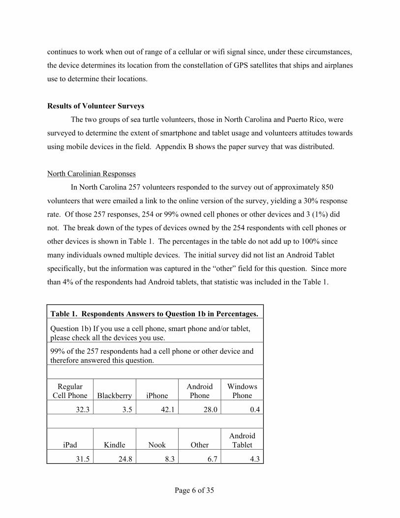
not. The break down of the types of devices owned by the 254 respondents with cell phones or
other devices is shown in Table 1. The percentages in the table do not add up to 100% since
many individuals owned multiple devices. The initial survey did not list an Android Tablet
specifically, but the information was captured in the “other” field for this question. Since more
than 4% of the respondents had Android tablets, that statistic was included in the Table 1.
Table 1. Respondents Answers to Question 1b in Percentages.
Question 1b) If you use a cell phone, smart phone and/or tablet, please check all the devices you use.
99% of the 257 respondents had a cell phone or other device and therefore answered this question.
Regular
Cell Phone Blackberry iPhone Android Phone
Windows Phone
32.3 3.5 42.1 28.0 0.4
iPad Kindle Nook Other Android Tablet
31.5 24.8 8.3 6.7 4.3
Page 7 of 35
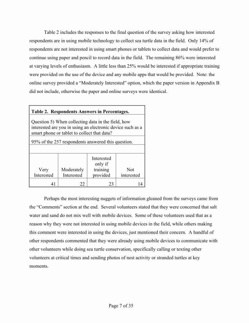
Table 2 includes the responses to the final question of the survey asking how interested
respondents are in using mobile technology to collect sea turtle data in the field. Only 14% of
respondents are not interested in using smart phones or tablets to collect data and would prefer to
continue using paper and pencil to record data in the field. The remaining 86% were interested
at varying levels of enthusiasm. A little less than 25% would be interested if appropriate training
were provided on the use of the device and any mobile apps that would be provided. Note: the
online survey provided a “Moderately Interested” option, which the paper version in Appendix B
did not include, otherwise the paper and online surveys were identical.
Table 2. Respondents Answers in Percentages.
Question 5) When collecting data in the field, how interested are you in using an electronic device such as a smart phone or tablet to collect that data?
95% of the 257 respondents answered this question.
Very Interested
Moderately Interested
Interested only if training provided
Not interested
41 22 23 14
Perhaps the most interesting nuggets of information gleaned from the surveys came from
the “Comments” section at the end. Several volunteers stated that they were concerned that salt
water and sand do not mix well with mobile devices. Some of these volunteers used that as a
reason why they were not interested in using mobile devices in the field, while others making
this comment were interested in using the devices, just mentioned their concern. A handful of
other respondents commented that they were already using mobile devices to communicate with
other volunteers while doing sea turtle conservation, specifically calling or texting other
volunteers at critical times and sending photos of nest activity or stranded turtles at key
moments.
Page 8 of 35
Puerto Rican Responses
In Puerto Rico, 55 respondents filled out a paper survey and 9 completed the online
survey yielding a total of 64 responses out of 105 people surveyed giving a 61% response rate.
Two reasons this response rate could be higher than North Carolina’s is that the network is
smaller than in North Carolina and all respondents were presented with the survey face to face at
a sea turtle meeting.
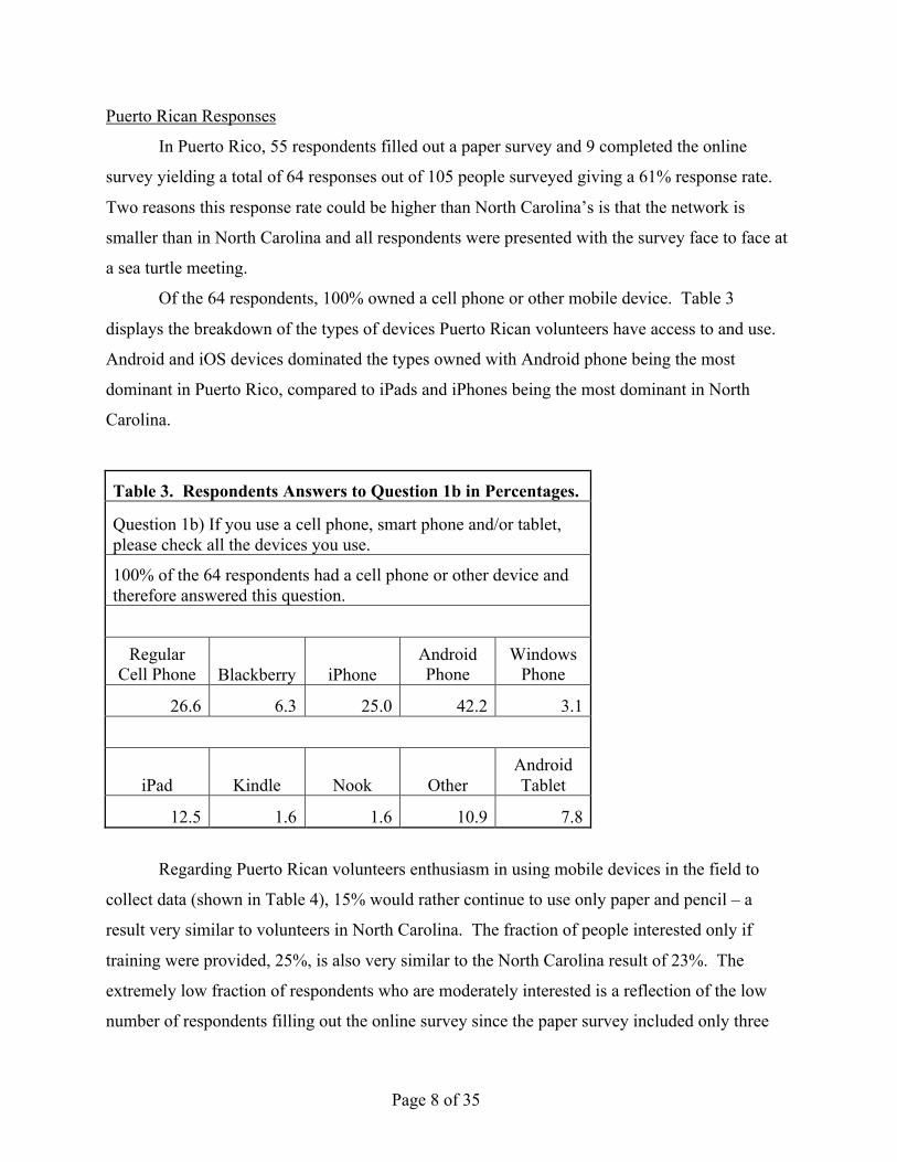
Of the 64 respondents, 100% owned a cell phone or other mobile device. Table 3
displays the breakdown of the types of devices Puerto Rican volunteers have access to and use.
Android and iOS devices dominated the types owned with Android phone being the most
dominant in Puerto Rico, compared to iPads and iPhones being the most dominant in North
Carolina.
Table 3. Respondents Answers to Question 1b in Percentages.
Question 1b) If you use a cell phone, smart phone and/or tablet, please check all the devices you use.
100% of the 64 respondents had a cell phone or other device and therefore answered this question.
Regular
Cell Phone Blackberry iPhone Android Phone
Windows Phone
26.6 6.3 25.0 42.2 3.1
iPad Kindle Nook Other Android Tablet
12.5 1.6 1.6 10.9 7.8
Regarding Puerto Rican volunteers enthusiasm in using mobile devices in the field to
collect data (shown in Table 4), 15% would rather continue to use only paper and pencil – a
result very similar to volunteers in North Carolina. The fraction of people interested only if
training were provided, 25%, is also very similar to the North Carolina result of 23%. The
extremely low fraction of respondents who are moderately interested is a reflection of the low
number of respondents filling out the online survey since the paper survey included only three
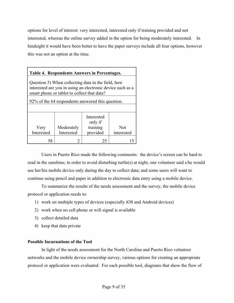
Page 9 of 35
options for level of interest: very interested, interested only if training provided and not
interested, whereas the online survey added in the option for being moderately interested. In
hindsight it would have been better to have the paper surveys include all four options, however
this was not an option at the time.
Table 4. Respondents Answers in Percentages.
Question 5) When collecting data in the field, how interested are you in using an electronic device such as a smart phone or tablet to collect that data?
92% of the 64 respondents answered this question.
Very Interested
Moderately Interested
Interested only if training provided
Not interested
58 2 25 15
Users in Puerto Rico made the following comments: the device’s screen can be hard to
read in the sunshine; in order to avoid disturbing turtle(s) at night, one volunteer said s/he would
use her/his mobile device only during the day to collect data; and some users will want to
continue using pencil and paper in addition to electronic data entry using a mobile device.
To summarize the results of the needs assessment and the survey, the mobile device
protocol or application needs to:
1) work on multiple types of devices (especially iOS and Android devices)
2) work when no cell phone or wifi signal is available
3) collect detailed data
4) keep that data private
Possible Incarnations of the Tool
In light of the needs assessment for the North Carolina and Puerto Rico volunteer
networks and the mobile device ownership survey, various options for creating an appropriate
protocol or application were evaluated. For each possible tool, diagrams that show the flow of
Page 10 of 35
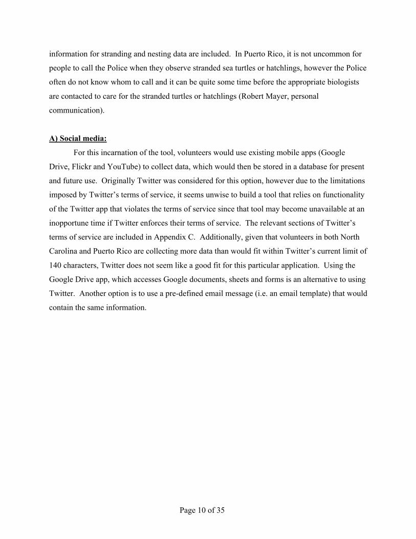
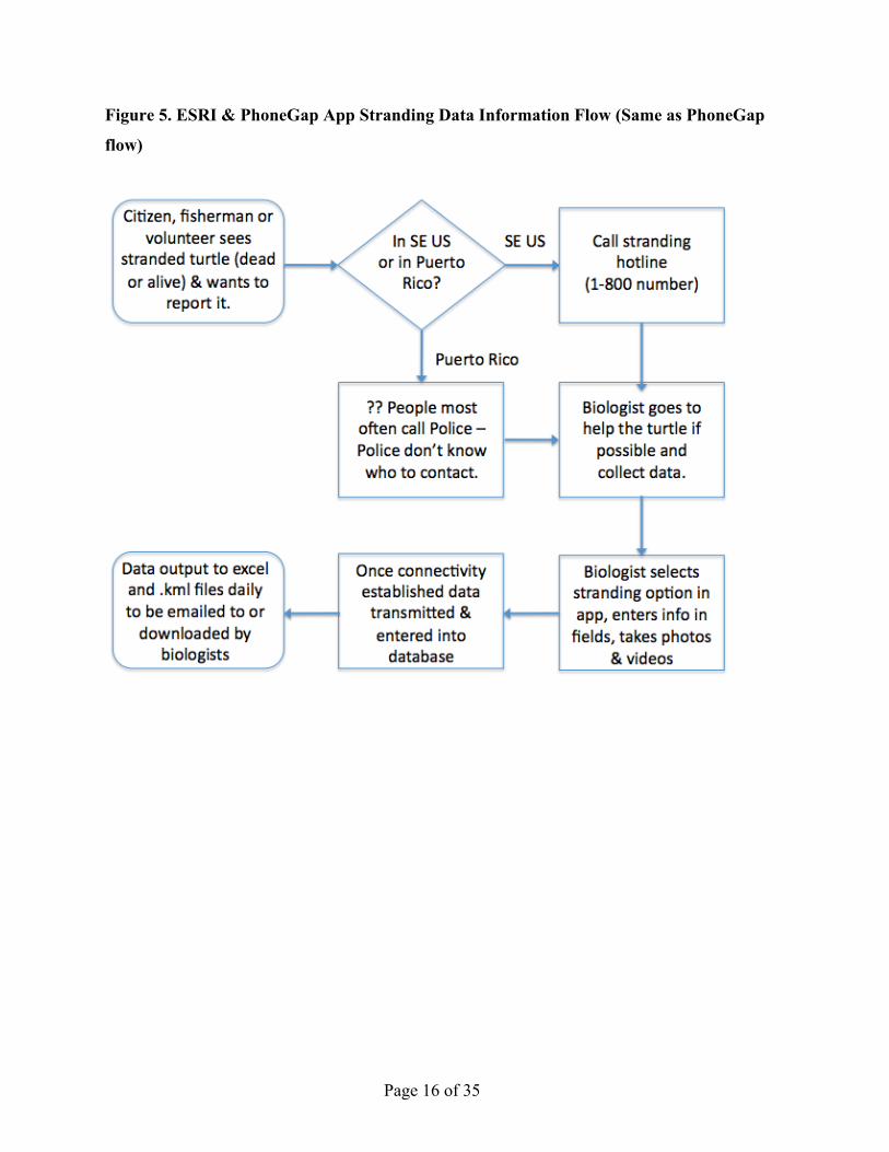
information for stranding and nesting data are included. In Puerto Rico, it is not uncommon for
people to call the Police when they observe stranded sea turtles or hatchlings, however the Police
often do not know whom to call and it can be quite some time before the appropriate biologists
are contacted to care for the stranded turtles or hatchlings (Robert Mayer, personal
communication).
A) Social media:
For this incarnation of the tool, volunteers would use existing mobile apps (Google
Drive, Flickr and YouTube) to collect data, which would then be stored in a database for present
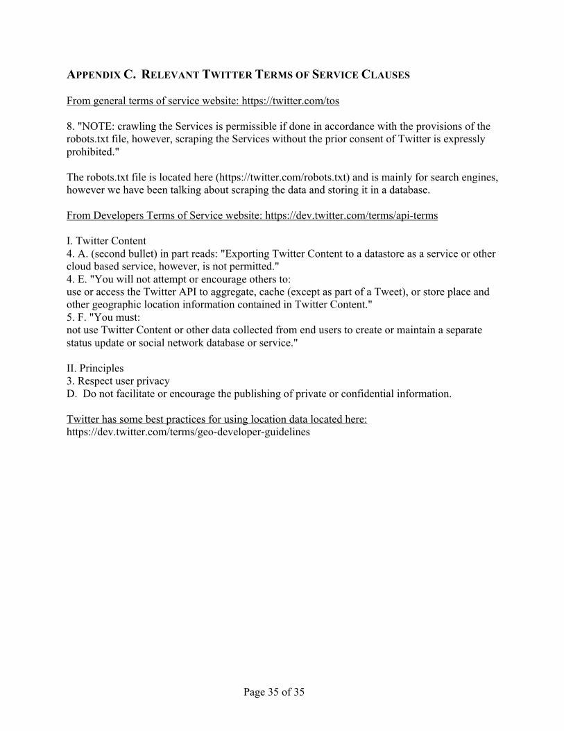
and future use. Originally Twitter was considered for this option, however due to the limitations
imposed by Twitter’s terms of service, it seems unwise to build a tool that relies on functionality
of the Twitter app that violates the terms of service since that tool may become unavailable at an
inopportune time if Twitter enforces their terms of service. The relevant sections of Twitter’s
terms of service are included in Appendix C. Additionally, given that volunteers in both North
Carolina and Puerto Rico are collecting more data than would fit within Twitter’s current limit of
140 characters, Twitter does not seem like a good fit for this particular application. Using the
Google Drive app, which accesses Google documents, sheets and forms is an alternative to using
Twitter. Another option is to use a pre-defined email message (i.e. an email template) that would
contain the same information.
Page 11 of 35
Figure 1. Social Media Stranding Data Information Flow
Page 12 of 35
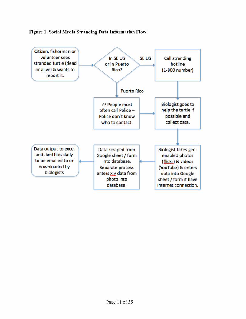
Figure 2. Social Media Nesting Information Flow
Pros:
-‐ Apps exist already, just need to write a protocol.
-‐ Users might already be familiar with the apps and how they function.
-‐ Information immediately available provided user has an Internet connection or cell phone
signal.
Cons:
-‐ Google sheets and forms do not work when no cellular or wifi signal is available.
-‐ Difficult to gather all the data desired. One idea is to have Puerto Rican volunteers take a
video of themselves verbally filling out a data sheet and then have undergraduate students
transcribe that data and enter it into a Google sheet or form which only they would know
about (in order to keep the data private). This is very time consuming and not a viable
option for North Carolina.
-‐ Twitter terms of service do not allow geo-enabled tweets to be stored in a database and
do not allow scraping of their service without prior consent.
Page 13 of 35
-‐ Users have to go through many hoops to keep the data private and even then, there is
some question about how private that data is since social media is, by design, meant to be
very public.
-‐ Added step of entering location information from geo-enabled photos or videos into
database from a separate location app. Not all location apps provide the accuracy of the
location, which is important information, especially when mobile devices are being used
since the accuracy can vary significantly from one location to the next.
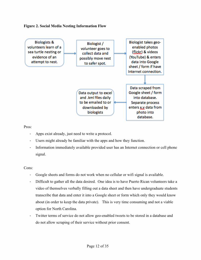
B) Stand-alone App using PhoneGap
For this incarnation of the tool, a stand-alone application for iOS and Android devices
(and other platforms as needed) would be created using a single software development
framework, PhoneGap.
Figure 3. Stand-alone PhoneGap App Stranding Data Information Flow
Page 14 of 35
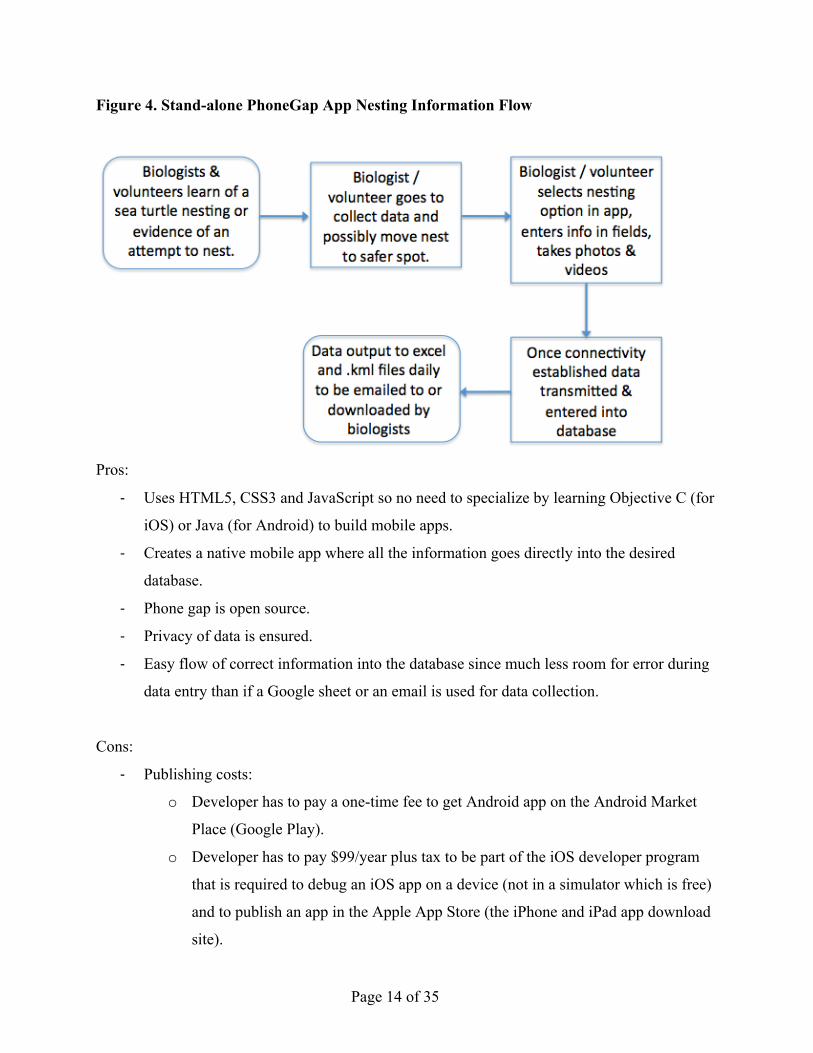
Figure 4. Stand-alone PhoneGap App Nesting Information Flow
Pros:
-‐ Uses HTML5, CSS3 and JavaScript so no need to specialize by learning Objective C (for
iOS) or Java (for Android) to build mobile apps.
-‐ Creates a native mobile app where all the information goes directly into the desired
database.
-‐ Phone gap is open source.
-‐ Privacy of data is ensured.
-‐ Easy flow of correct information into the database since much less room for error during
data entry than if a Google sheet or an email is used for data collection.
Cons:
-‐ Publishing costs:
o Developer has to pay a one-time fee to get Android app on the Android Market
Place (Google Play).
o Developer has to pay $99/year plus tax to be part of the iOS developer program
that is required to debug an iOS app on a device (not in a simulator which is free)
and to publish an app in the Apple App Store (the iPhone and iPad app download
site).
Page 15 of 35
-‐ Publishing time: approval of an iOS app is not instantaneous. The Apple review time, the
longest of all the platforms, at the time of publication is approximately 6 days.7
Developers can request an expedited review8 and a time-sensitive event is a legitimate
reason to request such a review. In the author’s opinion, the onset of sea turtle nesting
would qualify as a time-sensitive event.
C) ESRI SDK + PhoneGap
For this incarnation of the tool, ESRI’s Software Development Kit (SDK) would be used
to create a web map on ArcGIS Online that provides the background for an app. Location data
could be collected and viewed in near real time provided an Internet connection or cell phone
service is available.
This process would use ArcGIS online as the base map. It is useful if users want to
display the information that has been gathered in near real time. For sea turtle data collection,
this capability is probably not critical, though it does have a “gee wiz” factor in order to see
where other volunteers have observed turtles nesting or being stranded. This information could
be viewed from a web page displayed on a computer after the field session is over, however.
Page 16 of 35
Figure 5. ESRI & PhoneGap App Stranding Data Information Flow (Same as PhoneGap
flow)
Page 17 of 35
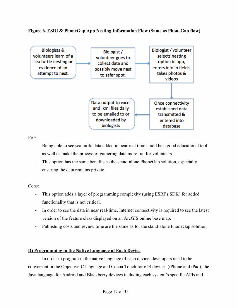
Figure 6. ESRI & PhoneGap App Nesting Information Flow (Same as PhoneGap flow)
Pros:
-‐ Being able to see sea turtle data added in near real time could be a good educational tool
as well as make the process of gathering data more fun for volunteers.
-‐ This option has the same benefits as the stand-alone PhoneGap solution, especially
ensuring the data remains private.
Cons:
-‐ This option adds a layer of programming complexity (using ESRI’s SDK) for added
functionality that is not critical.
-‐ In order to see the data in near real-time, Internet connectivity is required to see the latest
version of the feature class displayed on an ArcGIS online base map.
-‐ Publishing costs and review time are the same as for the stand-alone PhoneGap solution.
D) Programming in the Native Language of Each Device
In order to program in the native language of each device, developers need to be
conversant in the Objective-C language and Cocoa Touch for iOS devices (iPhone and iPad), the
Java language for Android and Blackberry devices including each system’s specific APIs and
Page 18 of 35
frameworks, and C# and Silverlight on Windows Phone.9, 10 (Note: Java is a completely
different language from JavaScript, though the two languages have similar names.) The flow of
information for natively programmed apps is the same as for the last two options, PhoneGap and
ESRI & PhoneGap, so the diagrams were not included again.
Pros:
-‐ Full range of programming possibilities available with a single debugging software
package.
Cons:
-‐ Large investment of time to learn appropriate operating system language for a single
platform.
-‐ Developers tend to specialize in a single language/platform so multiple developers could
be needed to create an app that will truly cross multiple platforms.
-‐ Lengthy period of time to develop an app on multiple platforms, leading to a more costly
solution.
-‐ Publishing costs and review time are the same as for the stand-alone PhoneGap solution.
DISCUSSION AND CONCLUSION While the original plan was to see if the framework used in the Coastal Walkabout
Project could be extended to sea turtle conservation, the need to keep the Puerto Rican data
private, the desire to collect detailed data and the need for offline functionality caused the project
to take a turn in a different direction and a stand-alone app emerged as the best-fit solution.
App Specification
Based on the discussions with conservation experts and the survey of existing technology
options, the following application features and requirements evolved:
1) Collect detailed data on nesting and stranding events with different sets of fields for each
event.
2) App must work when no Internet connection is available, i.e. when no cellular or wifi
signal is available. (Since almost all locations are expected to be out in the open,
Page 19 of 35
concerns about the difficulty in obtaining a GPS fix due to tall trees or buildings nearby
are minimal.)
3) App must save data when power to the device has been turned off (or the device runs out
of power due to a low battery while in the field.)
4) The app should work on multiple devices (e.g. iPhone and iPad) and multiple operating
systems (e.g. iOS and Android).
5) The data for Puerto Rico must be separate from the North Carolina data and must be kept
private.
Other desirable attributes:
6) App should work independent of the orientation of the device, and the user should be able
to zoom in on a page if needed to make the text or data entry fields larger.
7) The interface should be intuitive and easy to navigate.
Existing Customizable Data Collection Apps
Two customizable data collection apps currently exist: iGeoTrak and Open Data Kit.11
iGeoTrak12 is a fee-based comprehensive iOS solution, which allows users to create custom
forms for all types of data collection. Open Data Kit13 is a free, open-source option for Android
devices that also allows a variety of user created forms and data storage on a remote server. No
pre-existing solution for data collection across multiple platforms appears to be available at the
time of publication.
The Best-Fit Option
For this project, PhoneGap was the best option since the Puerto Rican data needs to
remain private, detailed data needs to be recorded, the volunteers have a range of types of mobile
devices, and by using HTML5, CSS3, and JavaScript, it was easier for the author to come up to
speed quickly to build a functional application in a relatively short period of time. The author
also felt that to get the highest quality data possible, it was important to make things as easy for
the user as possible. Following a protocol that uses multiple existing applications and a set of
private social media accounts did not seem to create a streamlined, positive user experience
especially given the other constraints of this project. Though PhoneGap does not provide every
Page 20 of 35
single native functionality available on a device, it provides access to all the native functionality
this project required included geolocation / GPS capability, camera and audio recording
capability, local storage on each type of device, and means to test for network connectivity.
The author chose to use jQuery-mobile14 to aid in creating a visually pleasing user
interface since a goal of the project was to get a working prototype of the app functioning as
soon as possible. By using existing user interface designs contained in jQuery-mobile, the author
could create a respectable-looking application extremely quickly. JQuery-mobile’s ThemeRoller
tool allows developers and designers to create new visual themes and apply them to an app in a
matter of minutes.
For the database on the back end or server-side of the application, the author decided to
use Parse.com, a cloud-based data storage option in the interest of time. Since Parse handles all
the server maintenance and the majority of the server-side programming, the author could focus
on the app itself. The core database structure was based on the data fields that North Carolina
uses for recording nesting and stranding events (see Appendix A), so data collected with the
Caretta app can be integrated with the SeaTurtle.org database at a future point in time if desired.
Though any user can download the app and enter data, only data submitted by users on
the “approved” or “blessed” list will be distributed to scientists who are also on the “blessed”
list. For the .csv and .kml creation, the author is expecting to use Python to convert the output
from the Parse.com database (JSON objects) into .csv and .kml files that will be available for
approved users to download from a secure website.
Caveats (Things to keep in mind)
As with any ongoing data gathering effort, maintenance of the database requires some
effort. Depending on the complexity of the data and the situation, this maintenance could be
minimal or rather extensive. As new versions of operating systems and programming
frameworks emerge, the code base will need to stay current. Using PhoneGap provides an
advantage in that the code base for all devices is basically the same, so updating that code is
much easier than for completely separate apps for iOS, Android, Blackberry, Windows Phone,
etc. which use different programming languages.
While using PhoneGap provides tangible gains in deploying an app across multiple
device operating systems, a few considerations bear keeping in mind. When moving an app
Page 21 of 35
from one platform to another, a few minor tweaks need to be performed. More importantly,
there are few comprehensive single-product debuggers for PhoneGap applications, though this is
an area where improvements are being made daily. Adobe, which distributes and supports the
open source PhoneGap framework has created the Edge Suite of tools for web development. The
Edge Inspect program, a debugger interface for mobile applications, appears to fill this gap.
Another difference between using PhoneGap and separate development paths is the ability to use
compatible frameworks and libraries such as JQuery-mobile, which makes creating a visually
pleasing mobile interface extremely fast. The down side to using these extra libraries is that
when debugging, making sure the library and third-party interface is working properly can be
harder to debug than code in a single language with a single library. Additionally, if unused
library elements are not removed when moving from a development app to a production app that
is ready for deployment, the resulting application can be bloated with unused library elements,
making it much less responsive than if those unused elements were removed.
The final consideration is position accuracy. While mobile devices can be relatively
accurate as seen in the device correctly locating itself on a map in an area with many cellular
towers and wifi hotspots, they also can be rather inaccurate as the large blue circle shows before
the device’s position is determined more accurately. If no cellular or wifi signal is available at a
particular beach where a sea turtle is nesting, the battery could be drained much more quickly as
the device uses its GPS capability to find its position – a notoriously energy intensive process.
Recording position accuracy along with latitude and longitude is an important parameter in order
to judge if the position data is sufficiently accurate for the project at hand. If extremely high
accuracy is needed, smartphones and tablets may not be an acceptable solution.
Conclusion
Even with the possible added programming and debugging challenges, the ability to use a
single, core code base for apps that deploy to all devices is a drastic time saver that significantly
outweighs the relatively minor considerations that need to be made to adapt the code for all
devices. Additionally, a wider pool of web development professionals can use their existing
knowledge of JavaScript, HTML5 and CSS3 with minor re-tooling costs to migrate into the
mobile world from the web. This could be extremely valuable to organizations that have limited
resources. If they have an interested web developer, he or she could branch into mobile
Page 22 of 35
development without having to invest the time to learn a new language such as Objective-C or
Java, they could more cost-effectively deploy an app to multiple device platforms, and can more
cheaply maintain those applications.
Compared to purchasing a fleet of programmable GPS units, using an app on a
smartphone or tablet can provide significant cost-savings for location-based data collection when
extreme accuracy is not necessary. Being able to enlist more people because the equipment costs
are low can lead to noticeable gains in the quantity of data collected, provided some basic level
of data quality is maintained.
While the benefits of using the Caretta app have yet to be realized, the gains for Puerto
Rico are likely to be larger initially than for North Carolina since a centralized database of sea
turtle data does not exist for Puerto Rico. However both locations could benefit if a significant
number of volunteers use the app while in the field. Long-term, having a larger quantity of
quality data available in a centralized database will likely aid scientists in gaining insights into
sea turtle biology.
Future Research and Improvements
It is expected that future versions of the application will include the capability to take a
photo, video, or audio recording associated with each nesting or stranding event. The names of
the photos, videos and audio recordings of an event will be stored with the event’s record so they
can be easily recalled. Providing a stranding hotline phone number and email address, which
users can call or email directly using their mobile device is a feature the author hopes to
incorporate in the next version of the app. After the iOS and Android versions of the app are
publically available, building Blackberry and Windows Phone versions is another possible future
improvement.
Providing the app in Spanish for Puerto Rican volunteers is an important improvement
the author would like to incorporate as soon as reasonably possible. Providing an additional .kml
file that aggregates the Puerto Rican nesting data to show only polygons for beaches in Puerto
Rico and list the number of nests on each beach is a mapping product that Robert Mayer would
find useful for public outreach. By aggregating the data at the beach level, private data can be
shared with the public to encourage people to become volunteers, but does not provide enough
information to put the nests at risk from poachers. Another feature that could be added is a
Page 23 of 35
mapping view that uses a cashed vector-based map that could be used offline to allow users to
compare where they are to the coastline on the cached map. This feature would be available
even when the device has no Internet connection.
If the volunteer organizations continue to use the application, moving the database to a
different server will likely be needed since there is a data and traffic limit to the Parse.com free
account. Additionally, switching to a MySQL or similar database on a Duke server may be
desirable as a step toward integration with the SeaTurtle.org database if that integration is
deemed a worthwhile endeavor.
Incorporating the capability to record data on simple observations of a sea turtle by the
general public could also be added with the goal of merging that data with the International Sea
Turtle Observation Registry (iSTOR)15 database. Others have suggested that including turtle
identification information could help reduce that number of sea turtle misidentifications in
addition to a side benefit of providing educational material in the app. Finally, expanding the
app to cover other states and/or countries could be a future enhancement that promotes increased
sea turtle conservation over a much larger geographic area.
Page 24 of 35
REFERENCES 1 “Summary of ESA” [Internet]. Environmental Protection Agency: [cited 9/3/2012]. Available from: http://www.epa.gov/lawsregs/laws/esa.html 2 “Sea Turtles” [Internet]. NOAA Fisheries Office of Protected Recourses: ©2012 [cited 9/3/2012]. Available from: http://www.nmfs.noaa.gov/pr/species/turtles/ 3 “Olive Ridley Sea Turtle Fact Sheet” [Internet]. U S Fish & Wildlife Service's North Florida ESO Jacksonville: ©2012 [cited 4/13/2013]. Available from: http://www.fws.gov/northflorida/SeaTurtles/Turtle%20Factsheets/olive-ridley-sea-turtle.htm 4 Coastal Walkabout Project [Internet]. Cetacean Research Unit, Murdoch University; Marine Conservation Ecology; BlueCloud Spatial: ©2012 [cited 9/3/2012]. Available from: http://superpod.ml.duke.edu/walkabout/ 5 Google Drive [Internet]. Google: [cited 2/25/2013]. Available from: http://www.google.com/drive/start/index.html 6 PhoneGap [Internet]. Adobe Systems Inc: ©2013 [cited 2/25/2013]. Available from: http://phonegap.com/about/ 7 “Average App Store Review Times” [Internet]. Shiny Development: ©2013 [cited 4/13/2013]. Available from: http://reviewtimes.shinydevelopment.com/ 8 “Request an Expedited App Review - App Store Resource Center” [Internet]. Apple Inc. ©2013 [cited 4/13/2013]. Available from: https://developer.apple.com/appstore/contact/appreviewteam/index.html 9 “HOW TO: Start Developing for iOS, Android or Windows Phone 7” [Internet]. Christina Warren, Mashable: ©Nov 07, 2010 [cited 2/25/2013]. Available from: http://mashable.com/2010/11/07/how-to-mobile-app-development/ 10 “Getting Started with Windows Phone Development” [Internet]. Microsoft: ©September 25, 2012 [cited 2/25/2013]. Available from: http://msdn.microsoft.com/en-us/library/ff402529%28v=vs.92%29.aspx 11 “Apps for Ocean Management and Conservation” [Internet]. Sarah Carr for OpenChannels [cited 2/25/2013]. Available from: http://openchannels.org/software-tools/apps-ocean-management-and-conservation 12 iGeoTrak [Internet]. Cogent3D, Inc.: [cited 2/25/2013]. Available from: http://igeotrak.com/ 13 Open Data Kit [Internet]. Open Data Kit: [cited 2/25/2013]. Available from: http://opendatakit.org/
Page 25 of 35
14 jQuery-mobile [Internet]. The jQuery Foundation: ©2013 [cited 2/25/2013]. Available from: jQuery http://jquerymobile.com/ 15 “Seaturtle.org – iSTOR” [Internet]. Seaturtle.org Inc.: ©1999-2009 [cited 4/13/2013]. Available from: http://www.seaturtle.org/istor/
Page 26 of 35
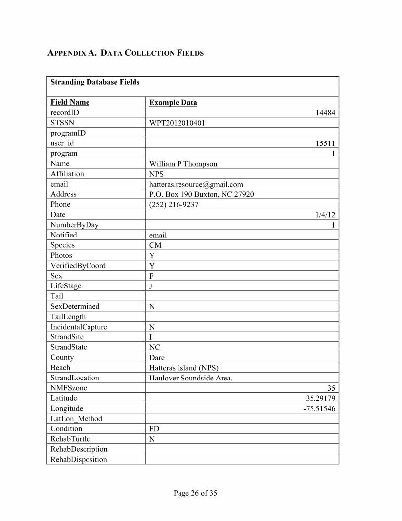
APPENDIX A. DATA COLLECTION FIELDS Stranding Database Fields Field Name Example Data recordID 14484 STSSN WPT2012010401 programID user_id 15511 program 1 Name William P Thompson Affiliation NPS email [email protected] Address P.O. Box 190 Buxton, NC 27920 Phone (252) 216-9237 Date 1/4/12 NumberByDay 1 Notified email Species CM Photos Y VerifiedByCoord Y Sex F LifeStage J Tail SexDetermined N TailLength IncidentalCapture N StrandSite I StrandState NC County Dare Beach Hatteras Island (NPS) StrandLocation Haulover Soundside Area. NMFSzone 35 Latitude 35.29179 Longitude -75.51546 LatLon_Method Condition FD RehabTurtle N RehabDescription RehabDisposition
Page 27 of 35
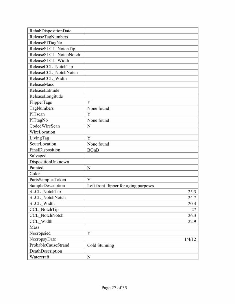
RehabDispositionDate ReleaseTagNumbers ReleasePITtagNo ReleaseSLCL_NotchTip ReleaseSLCL_NotchNotch ReleaseSLCL_Width ReleaseCCL_NotchTip ReleaseCCL_NotchNotch ReleaseCCL_Width ReleaseMass ReleaseLatitude ReleaseLongitude FlipperTags Y TagNumbers None found PITscan Y PITtagNo None found CodedWireScan N WireLocation LivingTag Y ScuteLocation None found FinalDisposition BOnB Salvaged DispositionUnknown Painted N Color PartsSamplesTaken Y SampleDescription Left front flipper for aging purposes SLCL_NotchTip 25.3 SLCL_NotchNotch 24.7 SLCL_Width 20.4 CCL_NotchTip 27 CCL_NotchNotch 26.3 CCL_Width 22.9 Mass Necropsied Y NecropsyDate 1/4/12 ProbableCauseStrand Cold Stunning DeathDescription Watercraft N
Page 28 of 35
Notes
Deep pink aorund the base of the appendages. Large amount of vegetation and barnacles growing on the carapace. Scavenged at the neck and front flippers. The heart and liver both looked good. Lungs were inflated with frozen bloody foam inside. Vegetation found throughout the GI tract and esophogus. Cold stun.
date_entered 1/4/12 14:00 last_modified 1/11/12 6:15 NMFS_date status 1 Prop_SL Prop_CL Prop_Width Prop_Depth Prop_Distance bid 1 beach_program 1 beach_name Hatteras Island (NPS) beach_admin beach_viewer 5,087,801,015,511 Owner Cape Hatteras Hatteras Biotech Year 2012 Month 1 Week 1
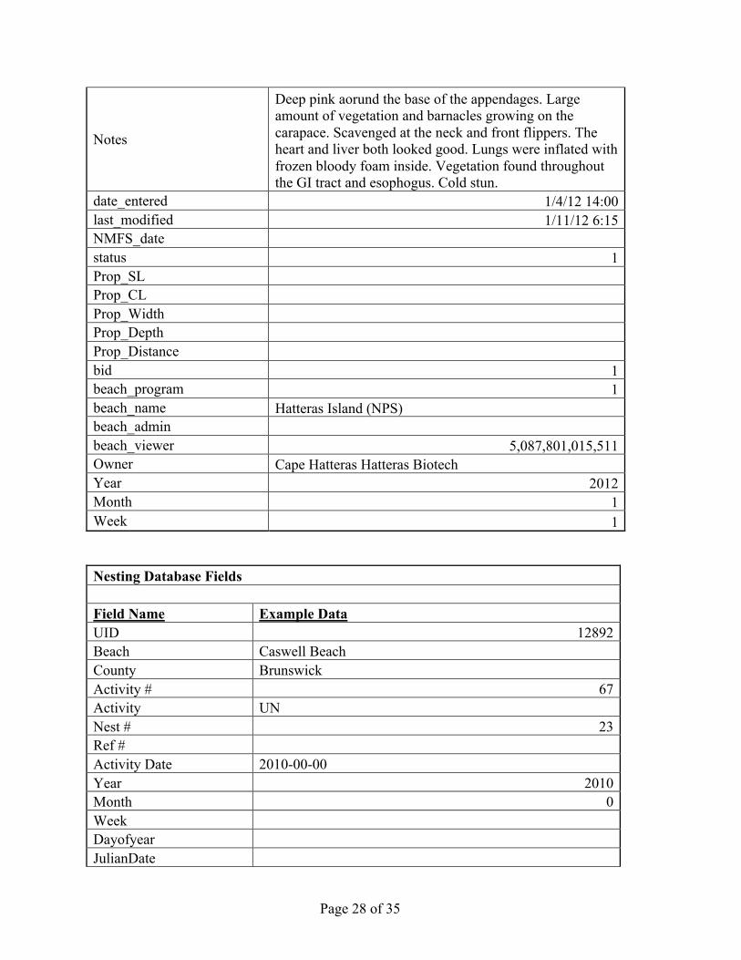
Nesting Database Fields Field Name Example Data UID 12892 Beach Caswell Beach County Brunswick Activity # 67 Activity UN Nest # 23 Ref # Activity Date 2010-00-00 Year 2010 Month 0 Week Dayofyear JulianDate
Page 29 of 35
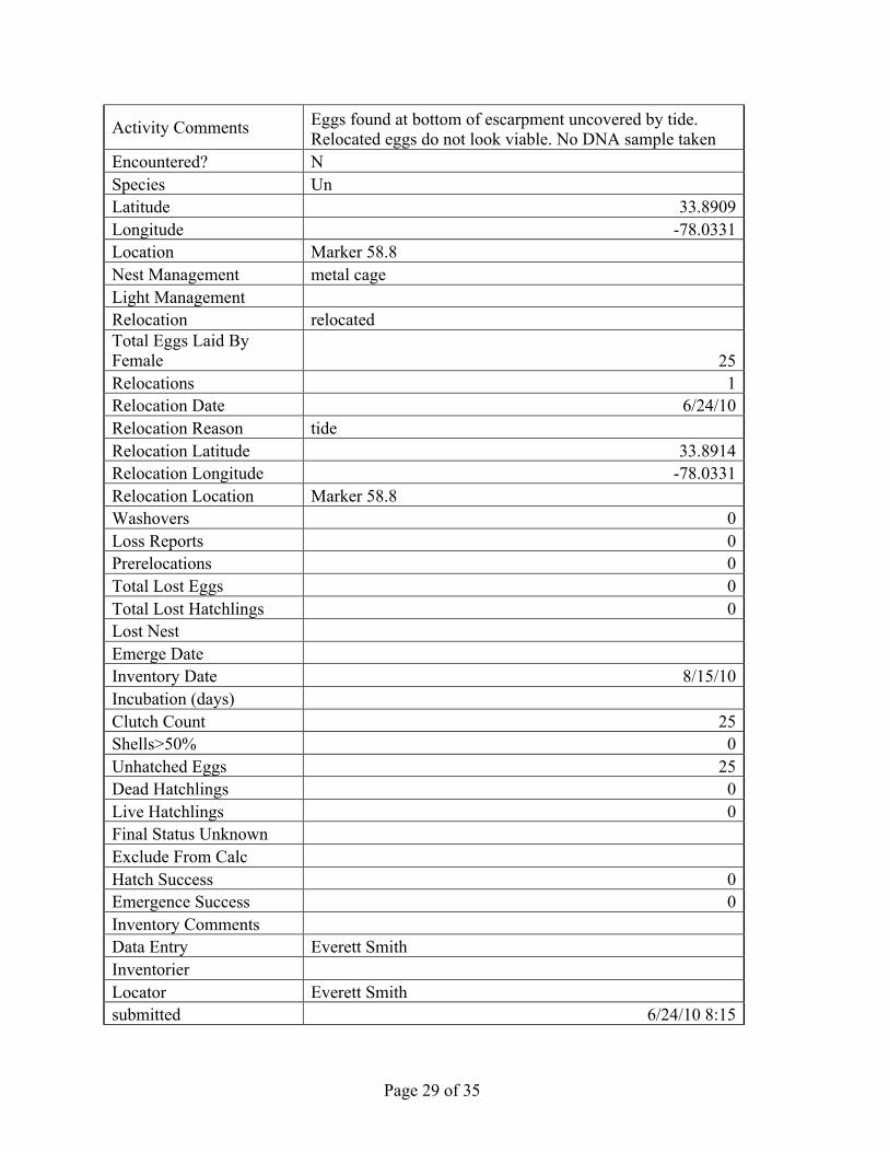
Activity Comments Eggs found at bottom of escarpment uncovered by tide. Relocated eggs do not look viable. No DNA sample taken
Encountered? N Species Un Latitude 33.8909 Longitude -78.0331 Location Marker 58.8 Nest Management metal cage Light Management Relocation relocated Total Eggs Laid By Female 25 Relocations 1 Relocation Date 6/24/10 Relocation Reason tide Relocation Latitude 33.8914 Relocation Longitude -78.0331 Relocation Location Marker 58.8 Washovers 0 Loss Reports 0 Prerelocations 0 Total Lost Eggs 0 Total Lost Hatchlings 0 Lost Nest Emerge Date Inventory Date 8/15/10 Incubation (days) Clutch Count 25 Shells>50% 0 Unhatched Eggs 25 Dead Hatchlings 0 Live Hatchlings 0 Final Status Unknown Exclude From Calc Hatch Success 0 Emergence Success 0 Inventory Comments Data Entry Everett Smith Inventorier Locator Everett Smith submitted 6/24/10 8:15
Page 30 of 35
modified 8/15/10 8:17 Program North Carolina
Page 31 of 35
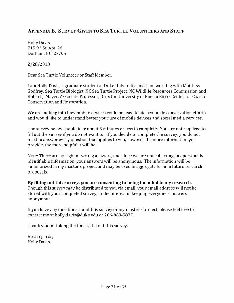
APPENDIX B. SURVEY GIVEN TO SEA TURTLE VOLUNTEERS AND STAFF Holly Davis 715 9th St. Apt. 26 Durham, NC 27705 2/28/2013 Dear Sea Turtle Volunteer or Staff Member, I am Holly Davis, a graduate student at Duke University, and I am working with Matthew Godfrey, Sea Turtle Biologist, NC Sea Turtle Project, NC Wildlife Resources Commission and Robert J. Mayer, Associate Professor, Director, University of Puerto Rico -‐ Center for Coastal Conservation and Restoration. We are looking into how mobile devices could be used to aid sea turtle conservation efforts and would like to understand better your use of mobile devices and social media services. The survey below should take about 5 minutes or less to complete. You are not required to fill out the survey if you do not want to. If you decide to complete the survey, you do not need to answer every question that applies to you, however the more information you provide, the more helpful it will be. Note: There are no right or wrong answers, and since we are not collecting any personally identifiable information, your answers will be anonymous. The information will be summarized in my master’s project and may be used in aggregate form in future research proposals. By filling out this survey, you are consenting to being included in my research. Though this survey may be distributed to you via email, your email address will not be stored with your completed survey, in the interest of keeping everyone’s answers anonymous. If you have any questions about this survey or my master’s project, please feel free to contact me at [email protected] or 206-‐883-‐5877. Thank you for taking the time to fill out this survey. Best regards, Holly Davis
Page 32 of 35
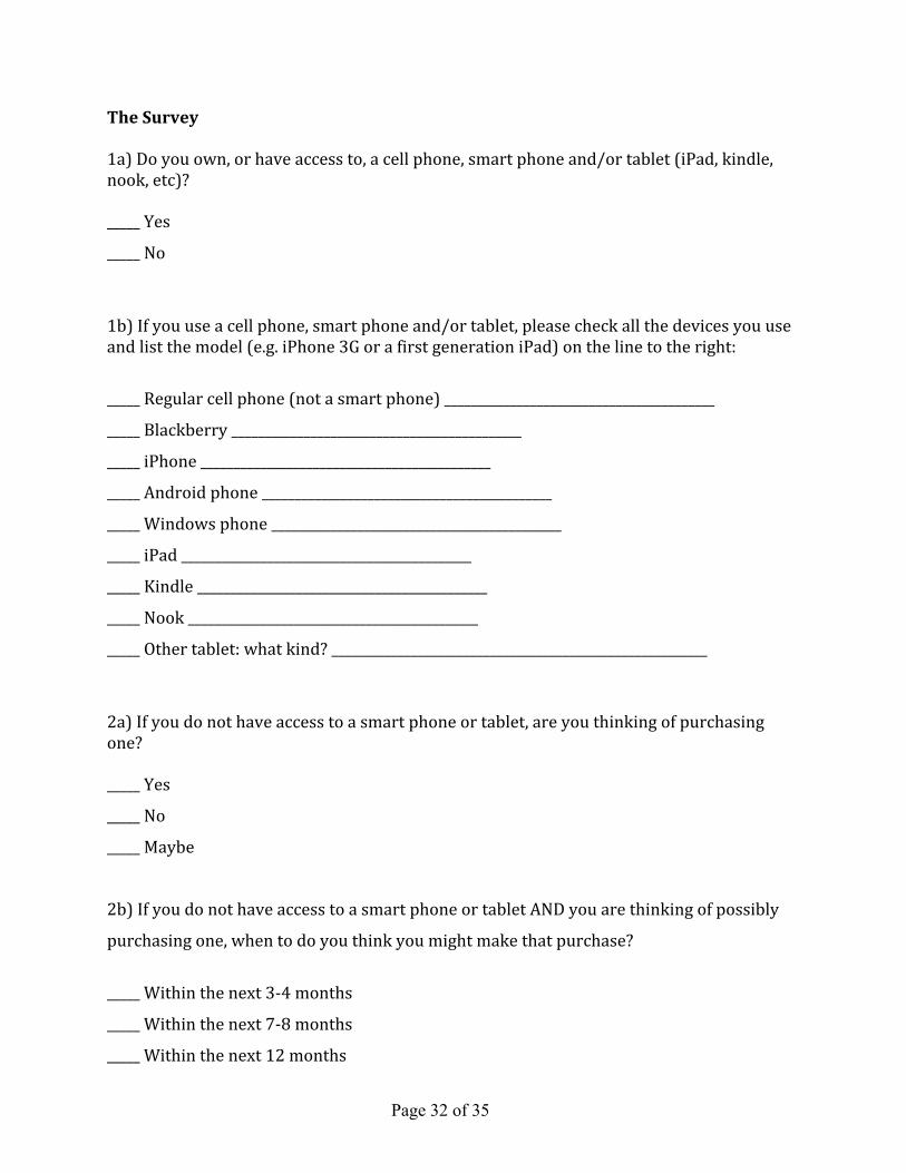
The Survey 1a) Do you own, or have access to, a cell phone, smart phone and/or tablet (iPad, kindle, nook, etc)? _____ Yes
_____ No
1b) If you use a cell phone, smart phone and/or tablet, please check all the devices you use and list the model (e.g. iPhone 3G or a first generation iPad) on the line to the right:
_____ Regular cell phone (not a smart phone) _________________________________________
_____ Blackberry ____________________________________________
_____ iPhone ____________________________________________
_____ Android phone ____________________________________________
_____ Windows phone ____________________________________________
_____ iPad ____________________________________________
_____ Kindle ____________________________________________
_____ Nook ____________________________________________
_____ Other tablet: what kind? _________________________________________________________
2a) If you do not have access to a smart phone or tablet, are you thinking of purchasing one? _____ Yes
_____ No
_____ Maybe
2b) If you do not have access to a smart phone or tablet AND you are thinking of possibly
purchasing one, when to do you think you might make that purchase?
_____ Within the next 3-‐4 months
_____ Within the next 7-‐8 months
_____ Within the next 12 months
Page 33 of 35
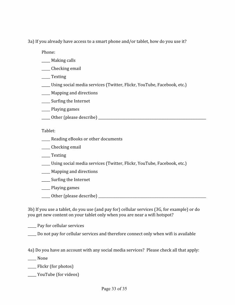
3a) If you already have access to a smart phone and/or tablet, how do you use it? Phone:
_____ Making calls
_____ Checking email
_____ Texting
_____ Using social media services (Twitter, Flickr, YouTube, Facebook, etc.)
_____ Mapping and directions
_____ Surfing the Internet
_____ Playing games
_____ Other (please describe) _______________________________________________________________
Tablet:
_____ Reading eBooks or other documents
_____ Checking email
_____ Texting
_____ Using social media services (Twitter, Flickr, YouTube, Facebook, etc.)
_____ Mapping and directions
_____ Surfing the Internet
_____ Playing games
_____ Other (please describe) _______________________________________________________________
3b) If you use a tablet, do you use (and pay for) cellular services (3G, for example) or do you get new content on your tablet only when you are near a wifi hotspot? _____ Pay for cellular services
_____ Do not pay for cellular services and therefore connect only when wifi is available
4a) Do you have an account with any social media services? Please check all that apply:
_____ None
_____ Flickr (for photos)
_____ YouTube (for videos)
Page 34 of 35
_____ Twitter (for posting comments/tweets)
_____ Other (please list) ______________________________________________________________________
4b) If you have accounts with social media services, are any of them private accounts?
_____ Yes
_____ No
4c) If you have private accounts with any social media services, and you are willing to
comment, could you list the services where you have a private account? ______________________
_________________________________________________________________________________________________________
(The intent of the question above is to understand how many users would need to obtain
private accounts for specific social media services that might be used to collect sensitive
sea turtle data that would need to be kept private.)
5) When collecting data in the field, how interested are you in using an electronic device
such as a smart phone or tablet to collect that data?
_____ Very interested
_____ Interested only if appropriate training were provided on how to use the device
_____ Not interested – I prefer to use paper and pencil to record information
Comments
_________________________________________________________________________________________________________
_________________________________________________________________________________________________________
_________________________________________________________________________________________________________
_________________________________________________________________________________________________________
_________________________________________________________________________________________________________
_________________________________________________________________________________________________________
Thank you, again, for your time!
Page 35 of 35
APPENDIX C. RELEVANT TWITTER TERMS OF SERVICE CLAUSES From general terms of service website: https://twitter.com/tos 8. "NOTE: crawling the Services is permissible if done in accordance with the provisions of the robots.txt file, however, scraping the Services without the prior consent of Twitter is expressly prohibited." The robots.txt file is located here (https://twitter.com/robots.txt) and is mainly for search engines, however we have been talking about scraping the data and storing it in a database. From Developers Terms of Service website: https://dev.twitter.com/terms/api-terms I. Twitter Content 4. A. (second bullet) in part reads: "Exporting Twitter Content to a datastore as a service or other cloud based service, however, is not permitted." 4. E. "You will not attempt or encourage others to: use or access the Twitter API to aggregate, cache (except as part of a Tweet), or store place and other geographic location information contained in Twitter Content." 5. F. "You must: not use Twitter Content or other data collected from end users to create or maintain a separate status update or social network database or service." II. Principles 3. Respect user privacy D. Do not facilitate or encourage the publishing of private or confidential information. Twitter has some best practices for using location data located here: https://dev.twitter.com/terms/geo-developer-guidelines