Embed Size (px)
Citation preview
Published by Oxford Wessex Archaeology, a joint venture between Oxford Archaeology and Wessex Archaeology
© Oxford Archaeology Ltd 2017© Wessex Archaeology Ltd 2017
Oxford Archaeology, Janus House, Osney Mead, Oxford, OX2 0ES
Wessex Archaeology, Portway House, Old Sarum Park, Salisbury, SP4 6EB
Front cover: Aerial view of the East Kent Access Phase 2 road under construction (view from south); Iron Age horse burial, Late Bronze Age gold bracelets, Roman dish with pig bone and Anglo-Saxon triple burial.Back cover: Open day in Zone 23–visitors viewing one of the Early Bronze Age ring ditches.
Oxford Archaeology Ltd is a company limited by guarantee registered in England, company number 1618597. It is a Charity registered in England and Wales, number 285627.Our registered offi ce is at Janus House, Osney Mead, Oxford, Oxfordshire, OX2 0ES.
Wessex Archaeology Ltd is a company limited by guarantee registered in England, company number 1712772. It is a Charity registered in England and Wales, number 287786 and in Scotland, Scottish Charity number SC042630.Our registered offi ce is at Portway House, Old Sarum Park, Salisbury, Wiltshire, SP4 6EB.
Former coastline
RamsgateRamsgate
Cliffs EndCliffs End
ManstonManston
Hollins BottomHollins Bottom
Foads HillFoads Hill
Cottington HillCottington Hill
Telegraph HillTelegraph Hill
MinsterMinster
Richborough PortRichborough Port
LondonThe Site
Oxford
NorwichBirmingham
River Stour
0 1 km
Pegwell Bay
EbbsfleetPeninsulaEbbsfleetPeninsula
Manston Airport
SevenscoreB2048
A253
A256
Zone 1
Zone 9
Zone 7
Zone 8
Zone 6
Zone 5
Zone 4
Zone 3
Zone 2
Zone 26
Zone 13
Zone 28
Zone 16
Zone 15Zone 14
Zone 12Zone 11
Zone 10Zone 10a
Zone 21a
Zone 20aZone 19a
Zone 18a
Zone 29
Zone 21 Zone 20
Zone 22
Zone 23
Zone 25
Zone24 Zone 19
Zone 18
Zone 17
Zone 1
Zone 9
Zone 7
Zone 8
Zone 6
Zone 5
Zone 4
Zone 3
Zone 2
Zone 26
Zone 13
Zone 28
Zone 16
Zone 15Zone 14
Zone 12Zone 11
Zone 10Zone 10a
Zone 21a
Zone 20aZone 19a
Zone 18a
Zone 29
Zone 21 Zone 20
Zone 22
Zone 23
Zone 25
Zone24 Zone 19
Zone 18
Zone 17
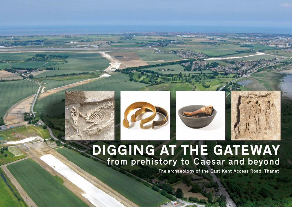
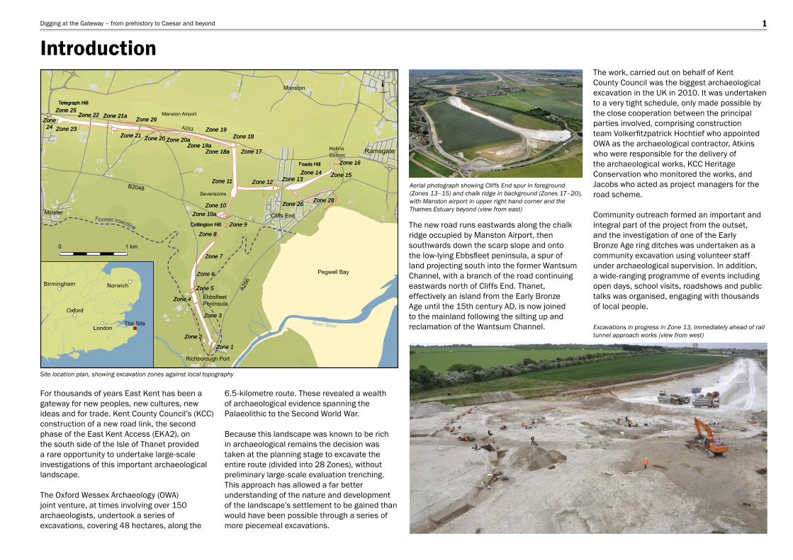
For thousands of years East Kent has been a gateway for new peoples, new cultures, new ideas and for trade. Kent County Council’s (KCC) construction of a new road link, the second phase of the East Kent Access (EKA2), on the south side of the Isle of Thanet provided a rare opportunity to undertake large-scale investigations of this important archaeological landscape. The Oxford Wessex Archaeology (OWA) joint venture, at times involving over 150 archaeologists, undertook a series of excavations, covering 48 hectares, along the
The new road runs eastwards along the chalk ridge occupied by Manston Airport, then southwards down the scarp slope and onto the low-lying Ebbsfl eet peninsula, a spur of land projecting south into the former Wantsum Channel, with a branch of the road continuing eastwards north of Cliffs End. Thanet, effectively an island from the Early Bronze Age until the 15th century AD, is now joined to the mainland following the silting up and reclamation of the Wantsum Channel.
6.5-kilometre route. These revealed a wealth of archaeological evidence spanning the Palaeolithic to the Second World War. Because this landscape was known to be rich in archaeological remains the decision was taken at the planning stage to excavate the entire route (divided into 28 Zones), without preliminary large-scale evaluation trenching. This approach has allowed a far better understanding of the nature and development of the landscape’s settlement to be gained than would have been possible through a series of more piecemeal excavations.
The work, carried out on behalf of Kent County Council was the biggest archaeological excavation in the UK in 2010. It was undertaken to a very tight schedule, only made possible by the close cooperation between the principal parties involved, comprising construction team Volkerfi tzpatrick Hochtief who appointed OWA as the archaeological contractor, Atkins who were responsible for the delivery of the archaeological works, KCC Heritage Conservation who monitored the works, and Jacobs who acted as project managers for the road scheme.
Community outreach formed an important and integral part of the project from the outset, and the investigation of one of the Early Bronze Age ring ditches was undertaken as a community excavation using volunteer staff under archaeological supervision. In addition, a wide-ranging programme of events including open days, school visits, roadshows and public talks was organised, engaging with thousands of local people.
Site location plan, showing excavation zones against local topography
Aerial photograph showing Cliffs End spur in foreground (Zones 13–15) and chalk ridge in background (Zones 17–20), with Manston airport in upper right hand corner and the Thames Estuary beyond (view from east)
Excavations in progress in Zone 13, immediately ahead of rail tunnel approach works (view from west)
IntroductionDigging at the Gateway – from prehistory to Caesar and beyond 1

With the exception of a single fl int fl ake of probable Palaeolithic date and one further Late Upper Palaeolithic/Early Mesolithic piece, the earliest discoveries were a Mesolithic tranchet axe and a small number of microliths and other diagnostic pieces of similar date. Although all the Mesolithic material was found residually in later features, it was concentrated on the low-lying ground of the Ebbsfl eet peninsula, before the rising sea-level during this period had fully encroached on the Wantsum Channel and rendered Thanet an island.
Two small groups of Early Neolithic pits with associated assemblages of pottery and worked fl int represent rare occurrences in this landscape, which included the nearby Early Neolithic causewayed enclosure at Chalk Hill, Ramsgate. The radiocarbon dating of charred plant remains from the pits confi rmed the presence of fl ax in this period, along with grains of emmer wheat and hazelnut shell fragments. Notable concentrations of worked fl int on the Ebbsfl eet peninsula indicated locations of in situ knapping, exploiting different sources of the raw material. These included the east–west outcrop of good quality Bullhead fl int below the crest of the chalk ridge, fl int nodules from the chalk itself and poorer quality material provided by beach cobbles.
The earliest burial found during the investigation (in Zone 13) dated to the Middle Neolithic. The inhumation, an adult male aged between 46 and 65, had been laid on his left side in a fl exed position; no grave goods were found with the burial, the date of which was established by radiocarbon dating. Middle Neolithic Mortlake-style pottery was found in a pit (in Zone 10) which also contained worked fl int and a small amount of cremated human bone, probably from an infant.
Late Neolithic material was also generally sparse, although the presence in Zone 13 of a circular possible hengiform monument with
opposing entrances was suggested by the remains of an early enclosure defi ned by a ditch and bank. This occupied a prominent spur and overlooked Pegwell Bay. The monument, perhaps serving as an important local meeting place, had been almost completely dug away by an Early Bronze Age ring ditch at least a couple of centuries later. Two chisel arrowheads, one recovered from the Bronze Age ditch, the other from the enclosure’s interior, provide some evidence for Late Neolithic activity at this location, perhaps of a ceremonial nature.
Possible Late Neolithic hengiform monument replaced by Early Bronze Age ring ditch in Zone 13, with the rising ground of Foad’s Hill beyond (view from south-east)
Neolithic polished and fl aked fl int axes from Zones 6 and 11 Middle Neolithic pottery from a pit in Zone 10
Mesolithic and Neolithic (8500–2400 BC)Digging at the Gateway – from prehistory to Caesar and beyond 2
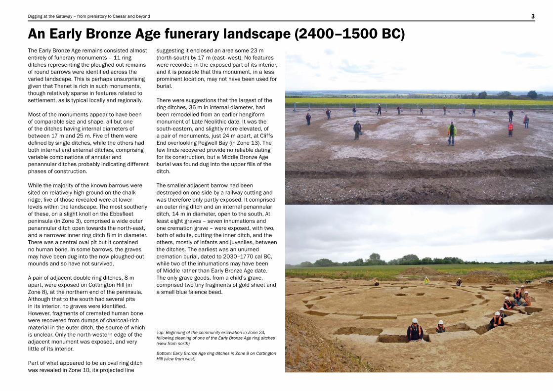
The Early Bronze Age remains consisted almost entirely of funerary monuments – 11 ring ditches representing the ploughed out remains of round barrows were identifi ed across the varied landscape. This is perhaps unsurprising given that Thanet is rich in such monuments, though relatively sparse in features related to settlement, as is typical locally and regionally.
Most of the monuments appear to have been of comparable size and shape, all but one of the ditches having internal diameters of between 17 m and 25 m. Five of them were defi ned by single ditches, while the others had both internal and external ditches, comprising variable combinations of annular and penannular ditches probably indicating different phases of construction. While the majority of the known barrows were sited on relatively high ground on the chalk ridge, fi ve of those revealed were at lower levels within the landscape. The most southerly of these, on a slight knoll on the Ebbsfl eet peninsula (in Zone 3), comprised a wide outer penannular ditch open towards the north-east, and a narrower inner ring ditch 8 m in diameter. There was a central oval pit but it contained no human bone. In some barrows, the graves may have been dug into the now ploughed-out mounds and so have not survived.
A pair of adjacent double ring ditches, 8 m apart, were exposed on Cottington Hill (in Zone 8), at the northern end of the peninsula. Although that to the south had several pits in its interior, no graves were identifi ed. However, fragments of cremated human bone were recovered from dumps of charcoal-rich material in the outer ditch, the source of which is unclear. Only the north-western edge of the adjacent monument was exposed, and very little of its interior.
Part of what appeared to be an oval ring ditch was revealed in Zone 10, its projected line
suggesting it enclosed an area some 23 m (north-south) by 17 m (east–west). No features were recorded in the exposed part of its interior, and it is possible that this monument, in a less prominent location, may not have been used for burial.
There were suggestions that the largest of the ring ditches, 36 m in internal diameter, had been remodelled from an earlier hengiform monument of Late Neolithic date. It was the south-eastern, and slightly more elevated, of a pair of monuments, just 24 m apart, at Cliffs End overlooking Pegwell Bay (in Zone 13). The few fi nds recovered provide no reliable dating for its construction, but a Middle Bronze Age burial was found dug into the upper fi lls of the ditch.
The smaller adjacent barrow had been destroyed on one side by a railway cutting and was therefore only partly exposed. It comprised an outer ring ditch and an internal penannular ditch, 14 m in diameter, open to the south. At least eight graves – seven inhumations and one cremation grave – were exposed, with two, both of adults, cutting the inner ditch, and the others, mostly of infants and juveniles, between the ditches. The earliest was an unurned cremation burial, dated to 2030–1770 cal BC, while two of the inhumations may have been of Middle rather than Early Bronze Age date. The only grave goods, from a child’s grave, comprised two tiny fragments of gold sheet and a small blue faience bead.
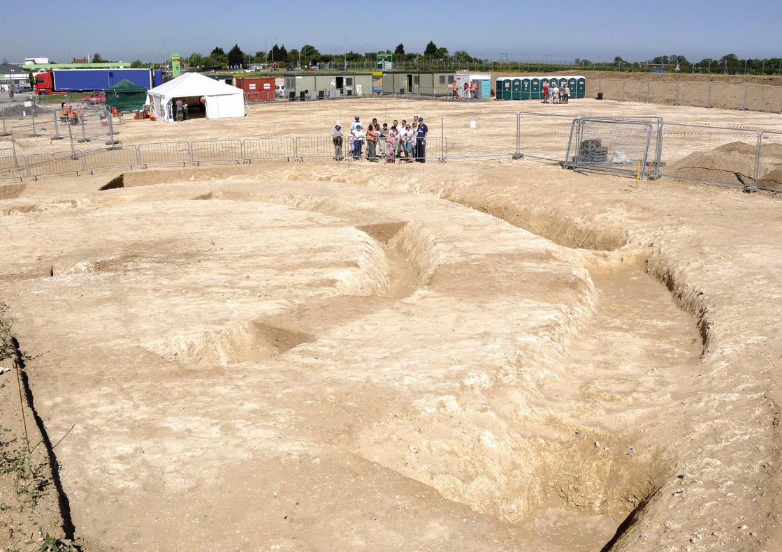
Top: Beginning of the community excavation in Zone 23, following cleaning of one of the Early Bronze Age ring ditches (view from north)
Bottom: Early Bronze Age ring ditches in Zone 8 on Cottington Hill (view from west)
An Early Bronze Age funerary landscape (2400–1500 BC)Digging at the Gateway – from prehistory to Caesar and beyond 3
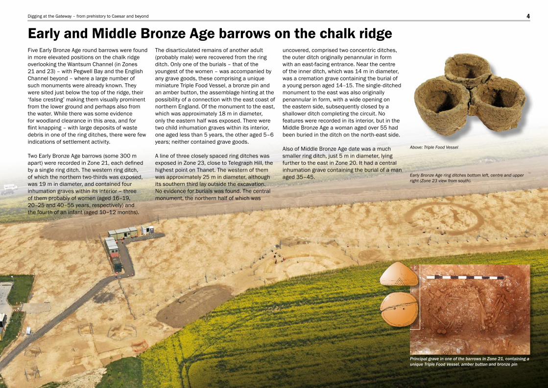
Five Early Bronze Age round barrows were found in more elevated positions on the chalk ridge overlooking the Wantsum Channel (in Zones 21 and 23) – with Pegwell Bay and the English Channel beyond – where a large number of such monuments were already known. They were sited just below the top of the ridge, their ‘false cresting’ making them visually prominent from the lower ground and perhaps also from the water. While there was some evidence for woodland clearance in this area, and for fl int knapping – with large deposits of waste debris in one of the ring ditches, there were few indications of settlement activity.
Two Early Bronze Age barrows (some 300 m apart) were recorded in Zone 21, each defi ned by a single ring ditch. The western ring ditch, of which the northern two-thirds was exposed, was 19 m in diameter, and contained four inhumation graves within its interior – three of them probably of women (aged 16–19, 20–25 and 40–55 years, respectively) and the fourth of an infant (aged 10–12 months).
The disarticulated remains of another adult (probably male) were recovered from the ring ditch. Only one of the burials – that of the youngest of the women – was accompanied by any grave goods, these comprising a unique miniature Triple Food Vessel, a bronze pin and an amber button, the assemblage hinting at the possibility of a connection with the east coast of northern England. Of the monument to the east, which was approximately 18 m in diameter, only the eastern half was exposed. There were two child inhumation graves within its interior, one aged less than 5 years, the other aged 5–6 years; neither contained grave goods. A line of three closely spaced ring ditches was exposed in Zone 23, close to Telegraph Hill, the highest point on Thanet. The western of them was approximately 25 m in diameter, although its southern third lay outside the excavation. No evidence for burials was found. The central monument, the northern half of which was
uncovered, comprised two concentric ditches, the outer ditch originally penannular in form with an east-facing entrance. Near the centre of the inner ditch, which was 14 m in diameter, was a cremation grave containing the burial of a young person aged 14–15. The single-ditched monument to the east was also originally penannular in form, with a wide opening on the eastern side, subsequently closed by a shallower ditch completing the circuit. No features were recorded in its interior, but in the Middle Bronze Age a woman aged over 55 had been buried in the ditch on the north-east side.
Also of Middle Bronze Age date was a much smaller ring ditch, just 5 m in diameter, lying further to the east in Zone 20. It had a central inhumation grave containing the burial of a man aged 35–45.
Above: Triple Food Vessel
Principal grave in one of the barrows in Zone 21, containing a unique Triple Food Vessel, amber button and bronze pin
Early Bronze Age ring ditches bottom left, centre and upper right (Zone 23 view from south).
Early and Middle Bronze Age barrows on the chalk ridgeDigging at the Gateway – from prehistory to Caesar and beyond 4
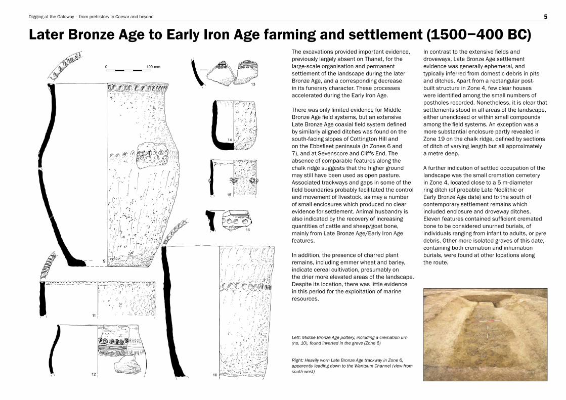
The excavations provided important evidence, previously largely absent on Thanet, for the large-scale organisation and permanent settlement of the landscape during the later Bronze Age, and a corresponding decrease in its funerary character. These processes accelerated during the Early Iron Age.
There was only limited evidence for Middle Bronze Age fi eld systems, but an extensive Late Bronze Age coaxial fi eld system defi ned by similarly aligned ditches was found on the south-facing slopes of Cottington Hill and on the Ebbsfl eet peninsula (in Zones 6 and 7), and at Sevenscore and Cliffs End. The absence of comparable features along the chalk ridge suggests that the higher ground may still have been used as open pasture. Associated trackways and gaps in some of the fi eld boundaries probably facilitated the control and movement of livestock, as may a number of small enclosures which produced no clear evidence for settlement. Animal husbandry is also indicated by the recovery of increasing quantities of cattle and sheep/goat bone, mainly from Late Bronze Age/Early Iron Age features.
In addition, the presence of charred plant remains, including emmer wheat and barley, indicate cereal cultivation, presumably onthe drier more elevated areas of the landscape. Despite its location, there was little evidence in this period for the exploitation of marine resources.
In contrast to the extensive fi elds and droveways, Late Bronze Age settlement evidence was generally ephemeral, and typically inferred from domestic debris in pits and ditches. Apart from a rectangular post-built structure in Zone 4, few clear houses were identifi ed among the small numbers of postholes recorded. Nonetheless, it is clear that settlements stood in all areas of the landscape, either unenclosed or within small compounds among the fi eld systems. An exception was a more substantial enclosure partly revealed in Zone 19 on the chalk ridge, defi ned by sections of ditch of varying length but all approximatelya metre deep.
A further indication of settled occupation of the landscape was the small cremation cemetery in Zone 4, located close to a 5 m-diameter ring ditch (of probable Late Neolithic or Early Bronze Age date) and to the south of contemporary settlement remains which included enclosure and droveway ditches. Eleven features contained suffi cient cremated bone to be considered unurned burials, of individuals ranging from infant to adults, or pyre debris. Other more isolated graves of this date, containing both cremation and inhumation burials, were found at other locations alongthe route.
Left: Middle Bronze Age pottery, including a cremation urn (no. 10), found inverted in the grave (Zone 6)
Right: Heavily worn Late Bronze Age trackway in Zone 6, apparently leading down to the Wantsum Channel (view from south-west)
Later Bronze Age to Early Iron Age farming and settlement (1500−400 BC)Digging at the Gateway – from prehistory to Caesar and beyond 5
Isle of Thanet
Weatherlees Hill
9m
8mA5
26 (S
andw
ich/R
amsg
ate
Road
)
Ebbs
fleet
Lan
e
R. Sto
ur
R. Stour
Ebbsfleet Farm
Former shoreline
10m
5m
5m
II
I
IIIV
VIIV
VIIIVII
Wantsum Channel
1
2
34
5 (x9)
6
9
7
8
0 500 m
0 5 km
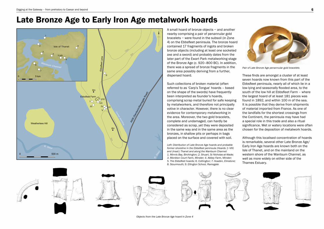
A small hoard of bronze objects − and another nearby comprising a pair of penannular gold bracelets − were found in the subsoil (in Zone 4) on the Ebbsfl eet peninsula. The bronze hoard contained 17 fragments of ingots and broken bronze objects (including at least one socketed axe and a sword) and probably dates from the later part of the Ewart Park metalworking stage of the Bronze Age (c. 920–800 BC). In addition, there was a spread of bronze fragments in the same area possibly deriving from a further, dispersed hoard.
Such collections of broken material (often referred to as ‘Carp’s Tongue’ hoards – based on the shape of the swords) have frequently been interpreted as founder’s hoards, comprising scrap metal buried for safe keeping by metalworkers, and therefore not principally votive in character. However, there is no clear evidence for contemporary metalworking in the area. Moreover, the two gold bracelets, complete and undamaged, can hardly be considered as scrap, yet they were deposited in the same way and in the same area as the bronzes, in shallow pits or perhaps in bags placed on the surface and covered with soil.
These fi nds are amongst a cluster of at least seven hoards now known from this part of the Ebbsfl eet peninsula, nearly all of which lie in a low-lying and seasonally fl ooded area, to the south of the low hill at Ebbsfl eet Farm – where the largest hoard of at least 181 pieces was found in 1892, and within 100 m of the sea. It is possible that they derive from shipments of material imported from France. As one of the landfalls for the shortest crossings from the Continent, the peninsula may have had a special role in this trade and also a ritual signifi cance. Wet or watery locations were often chosen for the deposition of metalwork hoards.
Although this localised concentration of hoards is remarkable, several other Late Bronze Age/Early Iron Age hoards are known both on the Isle of Thanet, and on the mainland on the western shore of the Wantsum Channel, aswell as more widely on either side of the Thames Estuary.
Left: Distribution of Late Bronze Age hoards and probable former shoreline in the Ebbsfl eet peninsula (Hoards 1−VIII) and (Inset:) Thanet and along the Wantsum Channel: 1. Minnis Bay, Birchington; 2. Shuart, St Nicholas-at-Wade; 3. Monkton Court Farm, Minster; 4. Abbey Farm, Minster; 5. The Ebbsfl eet hoards; 6. Cottington; 7. Hoaden, Elmstone; 8. Stourmouth; 9. Ellington School, Ramsgate
Pair of Late Bronze Age penannular gold bracelets
Objects from the Late Bronze Age hoard in Zone 4
Late Bronze Age to Early Iron Age metalwork hoardsDigging at the Gateway – from prehistory to Caesar and beyond 6
Enclosure ditch
Granary
Fence?
Pits
Pits
Pits
Sunken-featuredbuilding
Ramp down
Horse burial
Fence
Entrance
Early to Middle Iron Age feature
0 20m
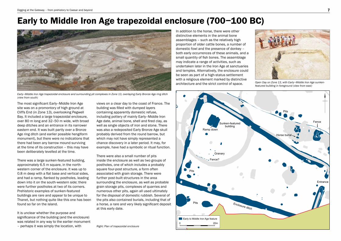
The most signifi cant Early–Middle Iron Age site was on a promontory of high ground at Cliffs End (in Zone 13), overlooking Pegwell Bay. It included a large trapezoidal enclosure, over 80 m long and 32–50 m wide, with broad deep ditches and an entrance in its narrower eastern end. It was built partly over a Bronze Age ring ditch (and earlier possible hengiform monument), but there were no indications that there had been any barrow mound surviving at the time of its construction – this may have been deliberately levelled at the time.
There was a large sunken-featured building, approximately 6.5 m square, in the north-western corner of the enclosure. It was up to 0.8 m deep with a fl at base and vertical sides, and had a ramp, fl anked by postholes, leading down into it on the south-western side; there were further postholes at two of its corners. Prehistoric examples of sunken-featured buildings are rare and appear to be unique to Thanet, but nothing quite like this one has been found so far on the island.
It is unclear whether the purpose and signifi cance of the building (and the enclosure) was related in any way to the earlier monument – perhaps it was simply the location, with
views on a clear day to the coast of France. The building was fi lled with dumped layers containing apparently domestic refuse, including pottery of mainly Early–Middle Iron Age date, animal bone, shell and fi red clay, as well as single objects of iron and stone. There was also a redeposited Early Bronze Age skull probably derived from the round barrow, but which may not have simply represented a chance discovery in a later period. It may, for example, have had a symbolic or ritual function.
There were also a small number of pits inside the enclosure as well as two groups of postholes, one of which includes a probably square four-post structure, a form often associated with grain storage. There were further post-built structures in the area surrounding the enclosure, as well as probable grain storage pits, complexes of quarries and numerous other pits, again all used ultimately for the disposal of domestic rubbish. Several of the pits also contained burials, including that of a horse, a rare and very likely signifi cant deposit at this early date.
In addition to the horse, there were other distinctive elements in the animal bone assemblages – such as the relatively high proportion of older cattle bones, a number of domestic fowl and the presence of donkey – both early occurrences of these animals, and a small quantity of fi sh bones. The assemblage may indicate a range of activities, such as undertaken later in the Iron Age at sanctuaries and temples. Alternatively, the enclosure could be seen as part of a high-status settlement with a religious element marked by distinctive architecture and the strict control of space.
Right: Plan of trapezoidal enclosure
Open Day on Zone 13, with Early−Middle Iron Age sunken-featured building in foreground (view from east)
Early–Middle Iron Age trapezoidal enclosure and surrounding pit complexes in Zone 13, overlaying Early Bronze Age ring ditch (view from south)
Early to Middle Iron Age trapezoidal enclosure (700−100 BC)Digging at the Gateway – from prehistory to Caesar and beyond 7
Right: Roundhouse reconstruction
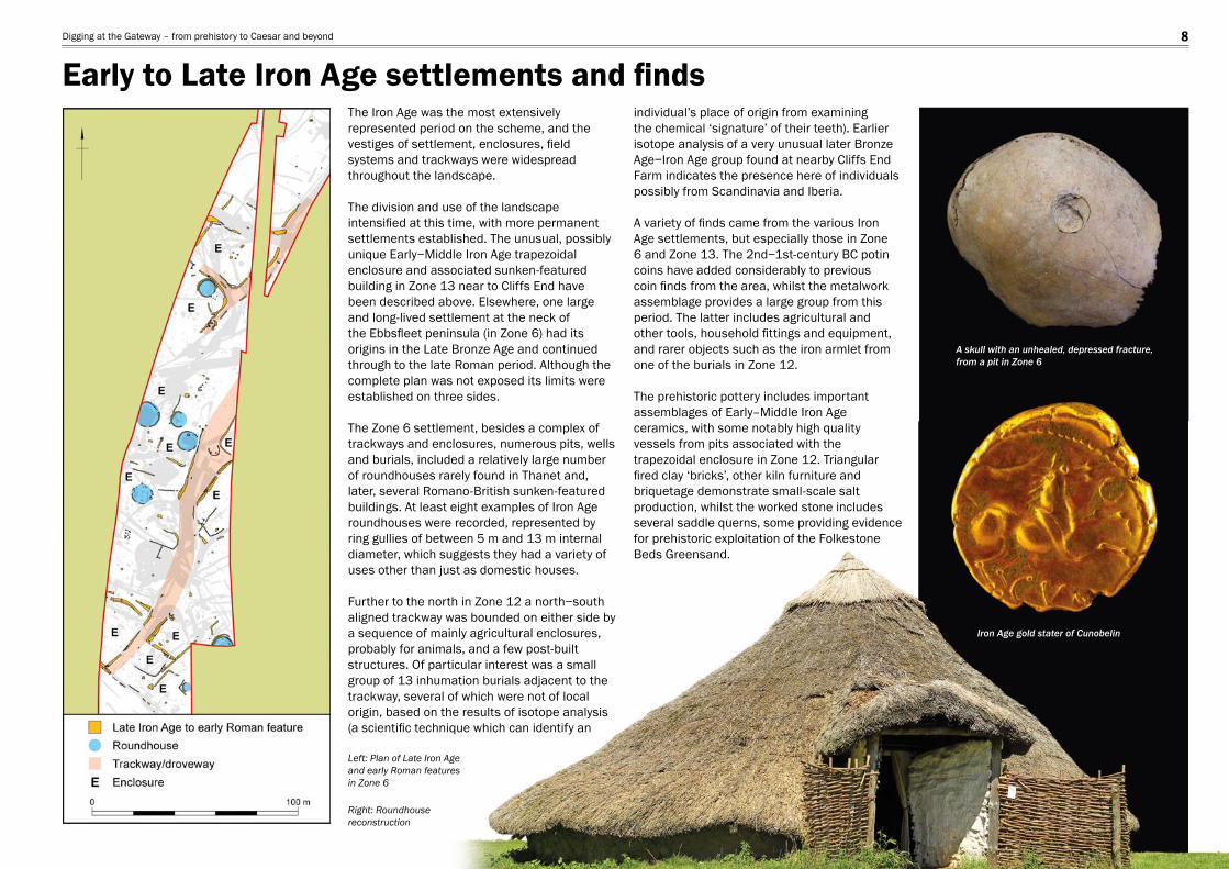
Left: Plan of Late Iron Age and early Roman features in Zone 6
The Iron Age was the most extensively represented period on the scheme, and the vestiges of settlement, enclosures, fi eld systems and trackways were widespread throughout the landscape.
The division and use of the landscape intensifi ed at this time, with more permanent settlements established. The unusual, possibly unique Early−Middle Iron Age trapezoidal enclosure and associated sunken-featured building in Zone 13 near to Cliffs End have been described above. Elsewhere, one large and long-lived settlement at the neck of the Ebbsfl eet peninsula (in Zone 6) had its origins in the Late Bronze Age and continued through to the late Roman period. Although the complete plan was not exposed its limits were established on three sides.
The Zone 6 settlement, besides a complex of trackways and enclosures, numerous pits, wells and burials, included a relatively large number of roundhouses rarely found in Thanet and, later, several Romano-British sunken-featured buildings. At least eight examples of Iron Age roundhouses were recorded, represented by ring gullies of between 5 m and 13 m internal diameter, which suggests they had a variety of uses other than just as domestic houses.
Further to the north in Zone 12 a north−south aligned trackway was bounded on either side by a sequence of mainly agricultural enclosures, probably for animals, and a few post-built structures. Of particular interest was a small group of 13 inhumation burials adjacent to the trackway, several of which were not of local origin, based on the results of isotope analysis (a scientifi c technique which can identify an
individual’s place of origin from examining the chemical ‘signature’ of their teeth). Earlier isotope analysis of a very unusual later Bronze Age−Iron Age group found at nearby Cliffs End Farm indicates the presence here of individuals possibly from Scandinavia and Iberia.
A variety of fi nds came from the various Iron Age settlements, but especially those in Zone 6 and Zone 13. The 2nd−1st-century BC potin coins have added considerably to previous coin fi nds from the area, whilst the metalwork assemblage provides a large group from this period. The latter includes agricultural and other tools, household fi ttings and equipment, and rarer objects such as the iron armlet from one of the burials in Zone 12.
The prehistoric pottery includes important assemblages of Early–Middle Iron Age ceramics, with some notably high quality vessels from pits associated with the trapezoidal enclosure in Zone 12. Triangular fi red clay ‘bricks’, other kiln furniture and briquetage demonstrate small-scale salt production, whilst the worked stone includes several saddle querns, some providing evidence for prehistoric exploitation of the Folkestone Beds Greensand.
A skull with an unhealed, depressed fracture,from a pit in Zone 6
Iron Age gold stater of Cunobelin
Early to Late Iron Age settlements and fi ndsDigging at the Gateway – from prehistory to Caesar and beyond 8
0 500 m
9m
8m
Projected lineof defences
2015 geophysicalsurvey
2015 geophysicalsurvey
Zone 7
Zone 62005 pipeline
(Ebbsfleet Lane)
Zone 4 and2005 Ebbsfleet Compound
Weatherlees Pond
EbbsfleetHill
Suggested former shoreline
10m
5m
5m
5m
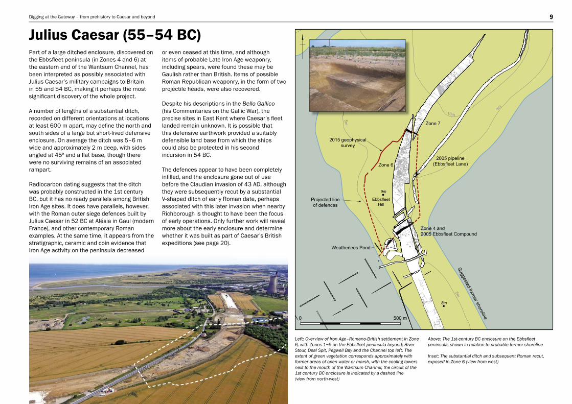
Part of a large ditched enclosure, discovered on the Ebbsfl eet peninsula (in Zones 4 and 6) at the eastern end of the Wantsum Channel, has been interpreted as possibly associated with Julius Caesar’s military campaigns to Britain in 55 and 54 BC, making it perhaps the most signifi cant discovery of the whole project.
A number of lengths of a substantial ditch, recorded on different orientations at locations at least 600 m apart, may defi ne the north and south sides of a large but short-lived defensive enclosure. On average the ditch was 5–6 m wide and approximately 2 m deep, with sides angled at 45º and a fl at base, though there were no surviving remains of an associated rampart.
Radiocarbon dating suggests that the ditch was probably constructed in the 1st century BC, but it has no ready parallels among British Iron Age sites. It does have parallels, however, with the Roman outer siege defences built by Julius Caesar in 52 BC at Alésia in Gaul (modern France), and other contemporary Roman examples. At the same time, it appears from the stratigraphic, ceramic and coin evidence that Iron Age activity on the peninsula decreased
or even ceased at this time, and although items of probable Late Iron Age weaponry, including spears, were found these may be Gaulish rather than British. Items of possible Roman Republican weaponry, in the form of two projectile heads, were also recovered.
Despite his descriptions in the Bello Gallico (his Commentaries on the Gallic War), the precise sites in East Kent where Caesar’s fl eet landed remain unknown. It is possible that this defensive earthwork provided a suitably defensible land base from which the shipscould also be protected in his secondincursion in 54 BC.
The defences appear to have been completely infi lled, and the enclosure gone out of use before the Claudian invasion of 43 AD, although they were subsequently recut by a substantial V-shaped ditch of early Roman date, perhaps associated with this later invasion when nearby Richborough is thought to have been the focus of early operations. Only further work will reveal more about the early enclosure and determine whether it was built as part of Caesar’s British expeditions (see page 20).
Left: Overview of Iron Age–Romano-British settlement in Zone 6, with Zones 1−5 on the Ebbsfl eet peninsula beyond; River Stour, Deal Spit, Pegwell Bay and the Channel top left. The extent of green vegetation corresponds approximately with former areas of open water or marsh, with the cooling towers next to the mouth of the Wantsum Channel; the circuit of the 1st century BC enclosure is indicated by a dashed line(view from north-west)
Above: The 1st-century BC enclosure on the Ebbsfl eet peninsula, shown in relation to probable former shoreline
Inset: The substantial ditch and subsequent Roman recut, exposed in Zone 6 (view from west)
Julius Caesar (55–54 BC) Digging at the Gateway – from prehistory to Caesar and beyond 9
Late Iron Age to early Roman feature
Enclosure
Graves
Graves
Grave
Settlementboundary ditch
SFB
Early Roman featureTrackway/droveway
EE
E
E
E
E
E
E
E
E
E0 50 m
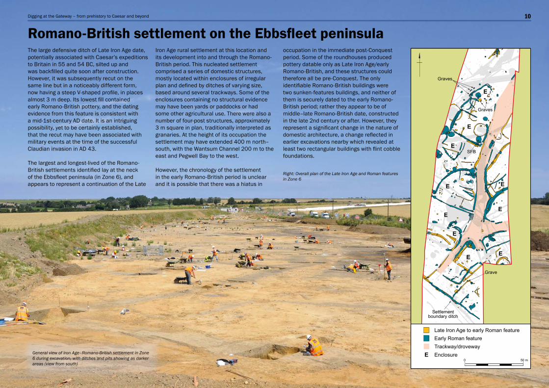
The large defensive ditch of Late Iron Age date, potentially associated with Caesar’s expeditions to Britain in 55 and 54 BC, silted up and was backfi lled quite soon after construction. However, it was subsequently recut on the same line but in a noticeably different form, now having a steep V-shaped profi le, in places almost 3 m deep. Its lowest fi ll contained early Romano-British pottery, and the dating evidence from this feature is consistent with a mid-1st-century AD date. It is an intriguing possibility, yet to be certainly established, that the recut may have been associated with military events at the time of the successful Claudian invasion in AD 43.
The largest and longest-lived of the Romano-British settlements identifi ed lay at the neck of the Ebbsfl eet peninsula (in Zone 6), and appears to represent a continuation of the Late
Iron Age rural settlement at this location and its development into and through the Romano-British period. This nucleated settlement comprised a series of domestic structures, mostly located within enclosures of irregular plan and defi ned by ditches of varying size, based around several trackways. Some of the enclosures containing no structural evidence may have been yards or paddocks or had some other agricultural use. There were also a number of four-post structures, approximately 3 m square in plan, traditionally interpreted as granaries. At the height of its occupation the settlement may have extended 400 m north–south, with the Wantsum Channel 200 m to the east and Pegwell Bay to the west.
However, the chronology of the settlement in the early Romano-British period is unclear and it is possible that there was a hiatus in
occupation in the immediate post-Conquest period. Some of the roundhouses produced pottery datable only as Late Iron Age/early Romano-British, and these structures could therefore all be pre-Conquest. The only identifi able Romano-British buildings were two sunken-features buildings, and neither of them is securely dated to the early Romano-British period; rather they appear to be of middle–late Romano-British date, constructed in the late 2nd century or after. However, they represent a signifi cant change in the nature of domestic architecture, a change refl ected in earlier excavations nearby which revealed at least two rectangular buildings with fl int cobble foundations.
Right: Overall plan of the Late Iron Age and Roman features in Zone 6
General view of Iron Age–Romano-British settlement in Zone 6 during excavation, with ditches and pits showing as darker areas (view from south)
Romano-British settlement on the Ebbsfl eet peninsulaDigging at the Gateway – from prehistory to Caesar and beyond 10
205150
205161171207
171243
Section 171207
171219
171239
171217
171241
E W
171215
171202
171219
205161
Section 171207
Steps down
171216
171209171208
171211171212
171210
171214
171222
171224 171225
171221
171223
171226
171230
171219
Oven
Post-holes forroof supports
47.92 m OD
0 2 m
0 5 m
0 200 mm0 500 mm 896
4029
Pottery
40314030
4030
896
215193
40304031
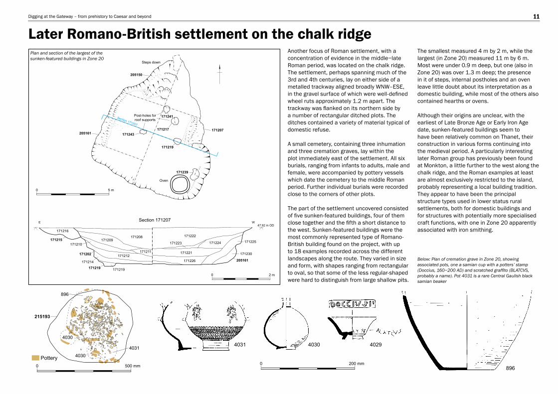
Another focus of Roman settlement, with a concentration of evidence in the middle−late Roman period, was located on the chalk ridge. The settlement, perhaps spanning much of the 3rd and 4th centuries, lay on either side of a metalled trackway aligned broadly WNW–ESE, in the gravel surface of which were well-defi ned wheel ruts approximately 1.2 m apart. The trackway was fl anked on its northern side by a number of rectangular ditched plots. The ditches contained a variety of material typical of domestic refuse.
A small cemetery, containing three inhumation and three cremation graves, lay within the plot immediately east of the settlement. All six burials, ranging from infants to adults, male and female, were accompanied by pottery vessels which date the cemetery to the middle Roman period. Further individual burials were recorded close to the corners of other plots.
The part of the settlement uncovered consisted of fi ve sunken-featured buildings, four of them close together and the fi fth a short distance to the west. Sunken-featured buildings were the most commonly represented type of Romano-British building found on the project, with up to 18 examples recorded across the different landscapes along the route. They varied in size and form, with shapes ranging from rectangular to oval, so that some of the less regular-shaped were hard to distinguish from large shallow pits.
The smallest measured 4 m by 2 m, while the largest (in Zone 20) measured 11 m by 6 m. Most were under 0.9 m deep, but one (also in Zone 20) was over 1.3 m deep; the presence in it of steps, internal postholes and an oven leave little doubt about its interpretation as a domestic building, while most of the others also contained hearths or ovens.
Although their origins are unclear, with the earliest of Late Bronze Age or Early Iron Age date, sunken-featured buildings seem to have been relatively common on Thanet, their construction in various forms continuing into the medieval period. A particularly interesting later Roman group has previously been found at Monkton, a little further to the west along the chalk ridge, and the Roman examples at least are almost exclusively restricted to the island, probably representing a local building tradition. They appear to have been the principal structure types used in lower status rural settlements, both for domestic buildings and for structures with potentially more specialised craft functions, with one in Zone 20 apparently associated with iron smithing.
Below: Plan of cremation grave in Zone 20, showing associated pots, one a samian cup with a potters’ stamp (Doccius, 160−200 AD) and scratched graffi to (BLATCVS, probably a name). Pot 4031 is a rare Central Gaulish black samian beaker
Plan and section of the largest of the sunken-featured buildings in Zone 20
Later Romano-British settlement on the chalk ridgeDigging at the Gateway – from prehistory to Caesar and beyond 11
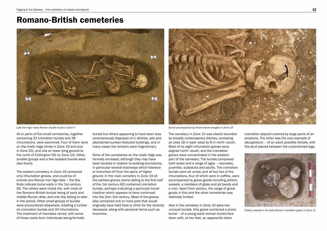
All or parts of fi ve small cemeteries, together containing 33 cremation burials and 38 inhumations, were examined. Four of them were on the chalk ridge (three in Zone 19 and one in Zone 20), and one on lower lying ground to the north of Cottington Hill (in Zone 10). Other, smaller groups and a few isolated burials were also found.
The western cemetery in Zone 19 contained only inhumation graves, and could be of entirely pre-Roman Iron Age date – the few fi nds indicate burial early in the 1st century AD. The others were mixed rite, with most of the Romano-British burials being of early and middle Roman date, and only few dating to later in the period. Other small groups of burials were encountered elsewhere, totalling a further six cremation burials and 34 inhumations. The treatment of neonates varied, with some of these newly-born individuals being formally
buried but others appearing to have been less ceremoniously disposed of in ditches, pits and abandoned sunken-featured buildings, and in many cases the remains were fragmentary.
None of the cemeteries on the chalk ridge was formally enclosed, although they may have been located in relation to existing boundaries, in particular several trackways which followed or branched off from the spine of higher ground. In the main cemetery in Zone 19 all the earliest graves (some dating to the fi rst half of the 1st century AD) contained cremation burials, perhaps indicating a particular burial tradition which appears to have continued into the 2nd–3rd century. Most of the graves also contained one or more pots that would originally have held food or drink for the recently deceased, along with personal items such as brooches.
The cemetery in Zone 10 was clearly bounded by broadly contemporary ditches, enclosing an area 18 m east–west by 8 m north–south. Most of its eight inhumation graves were aligned north–south, and the cremation graves were concentrated in the western part of the cemetery. The burials comprised both sexes and a range of ages – neonates, juveniles, subadults and adults. The cremation burials were all urned, and all but two of the inhumations, four of which were in coffi ns, were accompanied by grave goods including pottery vessels, a necklace of glass and jet beads and a coin. Apart from pottery, the range of grave goods in this and the other cemeteries was relatively limited.
Also in the cemetery in Zone 10 were two unusual burials. One grave contained a prone burial – of a young adult woman buried face down with, at her feet, an apparently token
cremation deposit covered by large parts of an amphora. The other was the only example of decapitation – of an adult possible female, with the skull placed between the outstretched legs.
Late Iron Age–early Roman double burial in Zone 4 Burial accompanied by three bronze bangles in Zone 19
Pottery vessels in an early Roman cremation grave in Zone 11
Romano-British cemeteriesDigging at the Gateway – from prehistory to Caesar and beyond 12
0 200 mm
0 250 mm
0 100 mm
Pottery, as is normal, was the most commonly occurring Roman fi nd, the earlier material – up to c. AD 70 − characterised by Belgic wares and continuity from the Late Iron Age rather than change, with most vessels wheel-made (or fi nished). Also present were imitation Gallo-Belgic forms refl ecting increased cross-Channel contacts and early imports of wine amphorae from the Mediterranean region. Other, slightly later imports included mortaria and fl agons from northern France, while various amphorae indicated the use of olive oil, fi sh-based products and olives, as well as wine, during the late 1st and early/mid-2nd century. There were few early examples of samian, with most of the South Gaulish material dating to afterc. AD 70. In the 2nd century much of the samian was from Lezoux, with other imports including Cologne colour-coated wares and Moselkeramic beakers. More local ceramic production is indicated by increasing quantities of sandy greyware from the Thameside industry and nearby sources, and by the late 1st century from the Canterbury kilns.
The Romano-British pottery is notable for the individual grave groups containing a variety of vessels, sometimes as containers for the cremated bone, and also for the use of birch bark tar for repair, a practice recorded elsewhere in Kent.
There was comparatively little roofi ng tile, fl ue tile and brick, the evidence indicating that most of the buildings were constructed of timber, wattle and daub with thatched roofs. Only a few more substantial buildings are known locally, such as the villa at Minster, however small amounts of brick and tile were used in hearths and ovens.
Amongst the less common objects were fragments of two pipe-clay fi gurines, one possibly of Venus, the other of Dea Nutrix (nursing goddess), which are likely to have been part of household shrines.
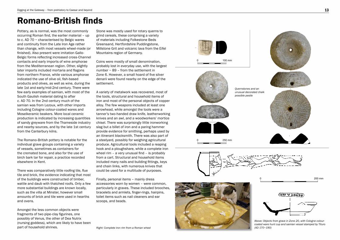
Stone was mostly used for rotary querns to grind cereals, these comprising a variety of materials including Folkestone Beds Greensand, Hertfordshire Puddingstone, Millstone Grit and volcanic lava from the Eifel Mountains region of Germany.
Coins were mostly of small denomination, probably lost in everyday use, with the largest number − 89 – from the settlement inZone 6. However, a small hoard of fi ve silver denarii were found nearby on the edge of the settlement.
A variety of metalwork was recovered, most of the tools, structural and household items of iron and most of the personal objects of copper alloy. The few weapons included at least one arrowhead, while amongst the tools were a tanner’s two-handed draw knife, leatherworking knives and an awl, and a woodworkers’ mortice chisel. There was surprisingly little ironworking slag but a billet of iron and a paring hammer provide evidence for smithing, perhaps used by an itinerant blacksmith. There was also part of a steelyard, possibly for weighing agricultural produce. Agricultural tools included a reaping hook and a ploughshare, while a complete iron wheel rim – a very unusual fi nd – is probably from a cart. Structural and household items included many nails and building fi ttings, keys and chain links, with numerous knives that could be used for a multitude of purposes.
Finally, personal items – mainly dress accessories worn by women – were common, particularly in graves. These included brooches, bracelets and armlets, fi nger-rings, hairpins, toilet items such as nail cleaners and ear scoops, and beads.
Right: Complete iron rim from a Roman wheel
Quernstones and an unusual decorated chalk possible pestle
Above: Objects from grave in Zone 20, with Cologne colour-coated ware hunt cup and samian vessel stamped by Tituro(AD 170−190)
Romano-British fi ndsDigging at the Gateway – from prehistory to Caesar and beyond 13
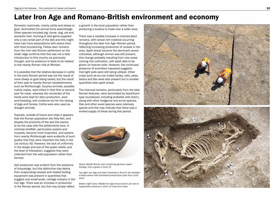
Domestic mammals, mainly cattle and sheep or goat, dominated the animal bone assemblage. Other species included pig, horse, dog, cat and domestic fowl. Hunting of wild game supplied only a very small part of the diet and this might have had more associations with status than with food provisioning. Fallow deer remains from the mid−late Roman settlement on the chalk ridge confi rms that this was not a later introduction to this country as previously thought, and its presence is likely to be related to the nearby Roman villa at Minster.
It is possible that the relative decrease in cattle in the early Roman period was not the result of more sheep or goat being raised, but the result of their sale to nearby Roman establishments such as Richborough. Surplus animals, possibly mainly males, were killed in their fi rst or second year for meat, whereas the remainder of the herds were kept for dairy production, wool and breeding, with evidence too for the raising of pigs and horses. Cattle were also used as draught animals.
Typically, outside of towns and villas it appears that the Roman population ate little fi sh, and despite the proximity of the sea this seems to be the case with the settlements here. In contrast shellfi sh, particularly oysters and mussels, became more important, and oysters from nearby Richborough were evidently of such quality that they were imported into Italy in the 1st century AD. However, the lack of uniformity in the shape and size of the oyster shells, and the level of infestation, suggests they were collected from the wild population rather than farmed.
Salt production was evident from the presence of briquetage, but this distinctive clay debris from evaporating vessels and related boiling equipment was present in quantities that suggest only small-scale, cottage industry in the Iron Age. There was an increase in production in the Roman period, but this may simply refl ect
a growth in the local population rather than producing a surplus to trade over a wider area.
There was a notable increase in charred plant remains, with cereal-rich material occurring throughout the later Iron Age−Roman period, refl ecting increasing production of cereals in the area. Spelt wheat became the dominant cereal cultivated, although emmer was still present, this change probably resulting from new areas coming into cultivation, with spelt able to be grown on heavier soils. However, the continued presence of scentless mayweed suggests that light soils were still being utilised. Other crops such as six-row hulled barley, oats, peas, beans and fl ax were also present but in smaller quantities than spelt wheat.
The charcoal remains, particularly from the later Roman features, were dominated by blackthorn-type roundwood, including probable wild cherry, along with other hedgerow and scrub species. Oak and other wood species were relatively sparse and this may indicate that there was a limited supply of these during this period.
Above: Middle Roman dish containing pig bone (upper foreleg), from a grave in Zone 10
Top right: Iron Age (and later) trackway in Zone 6, the metalled surface strewn with butchered animal bone (view from north-west)
Bottom right: Early–Middle Iron Age horse burial in pit next to trapezoidal enclosure in Zone 13 (view from west)
Later Iron Age and Romano-British environment and economyDigging at the Gateway – from prehistory to Caesar and beyond 14

The excavations have contributed substantially to our understanding of the earlier Anglo-Saxon period in Thanet. The principal remains comprised several cemeteries together probably spanning the mid-6th–early 8th centuries, and associated early–mid-Saxon settlement remains, for which there was previously little evidence in Thanet, or indeed more widely in Kent.
Although the Ebbsfl eet peninsula has traditionally been identifi ed as the landing place of Hengist and Horsa, the legendary leaders of the fi rst Anglo-Saxon invaders of Britain in c. 449, the fi rst tangible evidence for Saxon settlement comprises a number of richly-furnished graves in east Kent dating to the 6th century.
A dispersed group of three sunken-featured buildings lay on the lower slopes of Cottington Hill (in Zone 11), with parts of one or more cemeteries close to a complex of trackways higher up and extending along the chalk ridge. The buildings, with fl oors below ground level to provide protection from the elements, would have had thatched roofs and low walls of wattle and daub. Although the buildings cannot be closely dated, and may represent a succession of structures, one contained sherds from a decorated jar or bowl of 5th–6th-century date, while a nearby well produced pottery of late 6th–7th-century date.
Another building, some 500 m to the south (in Zone 10), is likely to have belonged to a separate settlement. Among the fi nds were sherds of Merovingian pottery imported from France in the 7th–8th century. The possible chronological overlap between the two areas provides rare evidence for settlement shift at the end of the 7th century.
This settlement evidence is enhanced by the presence of three probably broadly contemporary inhumation cemeteries, each
possibly associated with a separate settlement, or representing burial places which shifted over time. The earliest Anglo-Saxon burials here appear, mainly on the basis of grave goods, to be dated to c. 550 AD, and the latest to around 700. All the burials were made close to trackways along the chalk ridge (in Zone 19 and the eastern part of Zone 20) and the sites of the cemeteries would have been visible from the settlements, a kilometre or so downslope, as well as commanding extensive views over the Wantsum Channel. Most graves contained single burials, but there were two graves containing two individuals side-by-side and another grave with three. In addition, there were a small number of graves with two, or in one case three burials on top of each other, these multiple burials perhaps representing members of the same family. Many burials had associated grave goods, but a few apparent graves contained no human remains or fi nds, and while it is possible that these may have been robbed or revisited and the bone removed, it is perhaps more likely that some served as cenotaphs.
Above: Triple burial in grave 136111 (Zone 19; view from east)
Right: Wheel ruts of an Anglo-Saxon trackway running along the chalk ridge in Zone 19 (view from east)
Early to mid-Saxon settlement and cemeteriesDigging at the Gateway – from prehistory to Caesar and beyond 15
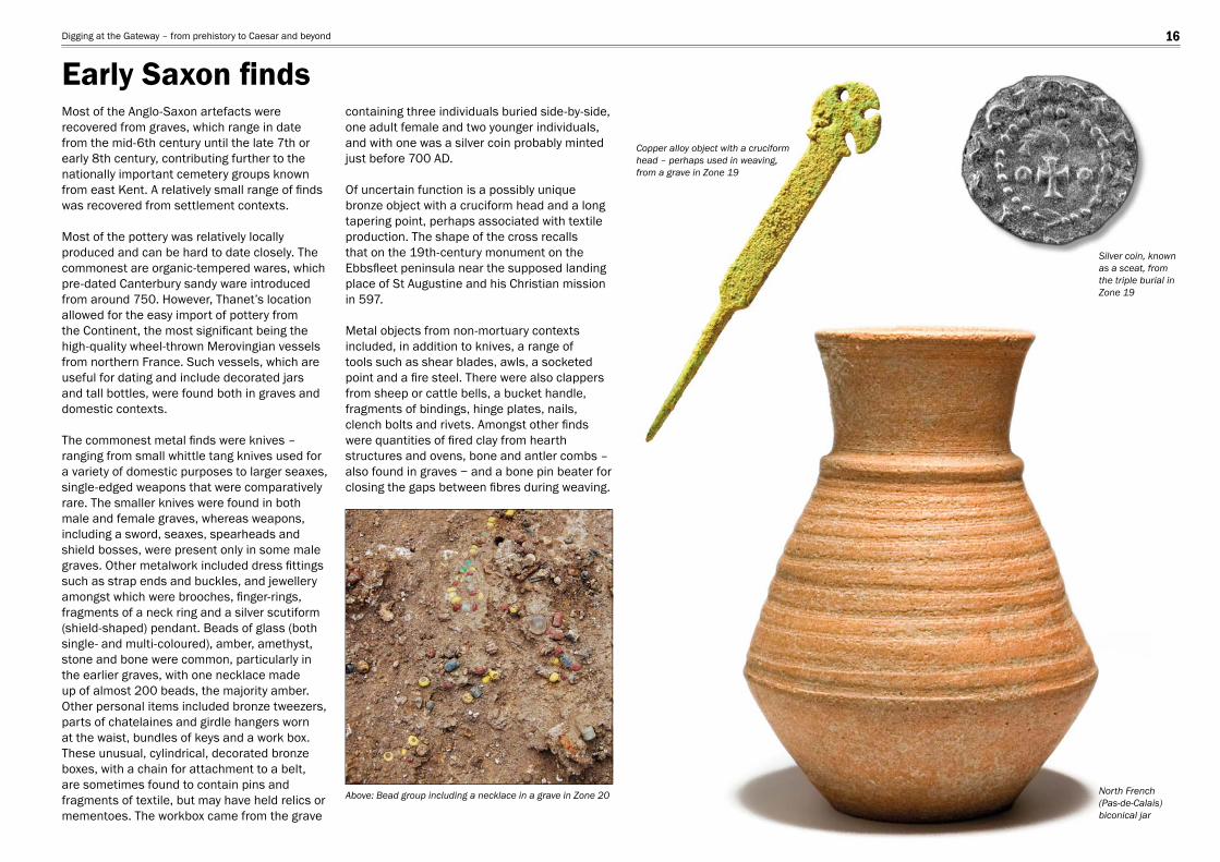
Most of the Anglo-Saxon artefacts were recovered from graves, which range in date from the mid-6th century until the late 7th or early 8th century, contributing further to the nationally important cemetery groups known from east Kent. A relatively small range of fi nds was recovered from settlement contexts.
Most of the pottery was relatively locally produced and can be hard to date closely. The commonest are organic-tempered wares, which pre-dated Canterbury sandy ware introduced from around 750. However, Thanet’s location allowed for the easy import of pottery from the Continent, the most signifi cant being the high-quality wheel-thrown Merovingian vessels from northern France. Such vessels, which are useful for dating and include decorated jars and tall bottles, were found both in graves and domestic contexts.
The commonest metal fi nds were knives – ranging from small whittle tang knives used for a variety of domestic purposes to larger seaxes, single-edged weapons that were comparatively rare. The smaller knives were found in both male and female graves, whereas weapons, including a sword, seaxes, spearheads and shield bosses, were present only in some male graves. Other metalwork included dress fi ttings such as strap ends and buckles, and jewellery amongst which were brooches, fi nger-rings, fragments of a neck ring and a silver scutiform (shield-shaped) pendant. Beads of glass (both single- and multi-coloured), amber, amethyst, stone and bone were common, particularly in the earlier graves, with one necklace made up of almost 200 beads, the majority amber. Other personal items included bronze tweezers, parts of chatelaines and girdle hangers worn at the waist, bundles of keys and a work box. These unusual, cylindrical, decorated bronze boxes, with a chain for attachment to a belt, are sometimes found to contain pins and fragments of textile, but may have held relics or mementoes. The workbox came from the grave
containing three individuals buried side-by-side, one adult female and two younger individuals, and with one was a silver coin probably minted just before 700 AD.
Of uncertain function is a possibly unique bronze object with a cruciform head and a long tapering point, perhaps associated with textile production. The shape of the cross recalls that on the 19th-century monument on the Ebbsfl eet peninsula near the supposed landing place of St Augustine and his Christian mission in 597.
Metal objects from non-mortuary contexts included, in addition to knives, a range of tools such as shear blades, awls, a socketed point and a fi re steel. There were also clappers from sheep or cattle bells, a bucket handle, fragments of bindings, hinge plates, nails, clench bolts and rivets. Amongst other fi nds were quantities of fi red clay from hearth structures and ovens, bone and antler combs – also found in graves − and a bone pin beater for closing the gaps between fi bres during weaving.
Above: Bead group including a necklace in a grave in Zone 20
Copper alloy object with a cruciform head – perhaps used in weaving, from a grave in Zone 19
Silver coin, known as a sceat, from the triple burial in Zone 19
North French (Pas-de-Calais) biconical jar
Early Saxon fi ndsDigging at the Gateway – from prehistory to Caesar and beyond 16
0 100 mm
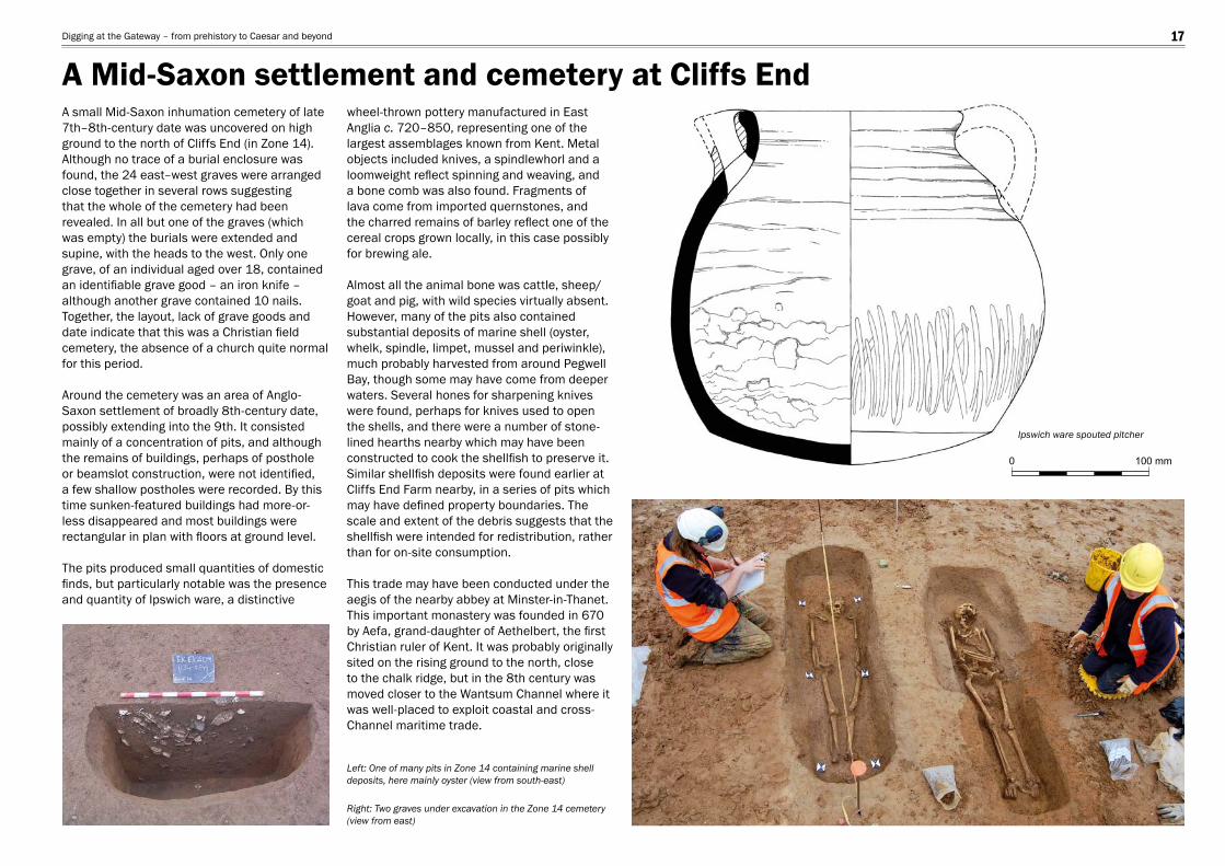
A small Mid-Saxon inhumation cemetery of late 7th–8th-century date was uncovered on high ground to the north of Cliffs End (in Zone 14). Although no trace of a burial enclosure was found, the 24 east–west graves were arranged close together in several rows suggesting that the whole of the cemetery had been revealed. In all but one of the graves (which was empty) the burials were extended and supine, with the heads to the west. Only one grave, of an individual aged over 18, contained an identifi able grave good – an iron knife – although another grave contained 10 nails. Together, the layout, lack of grave goods and date indicate that this was a Christian fi eld cemetery, the absence of a church quite normal for this period.
Around the cemetery was an area of Anglo-Saxon settlement of broadly 8th-century date, possibly extending into the 9th. It consisted mainly of a concentration of pits, and although the remains of buildings, perhaps of posthole or beamslot construction, were not identifi ed, a few shallow postholes were recorded. By this time sunken-featured buildings had more-or-less disappeared and most buildings were rectangular in plan with fl oors at ground level.
The pits produced small quantities of domestic fi nds, but particularly notable was the presence and quantity of Ipswich ware, a distinctive
wheel-thrown pottery manufactured in East Anglia c. 720–850, representing one of the largest assemblages known from Kent. Metal objects included knives, a spindlewhorl and a loomweight refl ect spinning and weaving, and a bone comb was also found. Fragments of lava come from imported quernstones, and the charred remains of barley refl ect one of the cereal crops grown locally, in this case possibly for brewing ale.
Almost all the animal bone was cattle, sheep/goat and pig, with wild species virtually absent. However, many of the pits also contained substantial deposits of marine shell (oyster, whelk, spindle, limpet, mussel and periwinkle), much probably harvested from around Pegwell Bay, though some may have come from deeper waters. Several hones for sharpening knives were found, perhaps for knives used to open the shells, and there were a number of stone-lined hearths nearby which may have been constructed to cook the shellfi sh to preserve it. Similar shellfi sh deposits were found earlier at Cliffs End Farm nearby, in a series of pits which may have defi ned property boundaries. The scale and extent of the debris suggests that the shellfi sh were intended for redistribution, rather than for on-site consumption.
This trade may have been conducted under the aegis of the nearby abbey at Minster-in-Thanet. This important monastery was founded in 670 by Aefa, grand-daughter of Aethelbert, the fi rst Christian ruler of Kent. It was probably originally sited on the rising ground to the north, close to the chalk ridge, but in the 8th century was moved closer to the Wantsum Channel where it was well-placed to exploit coastal and cross-Channel maritime trade.
Ipswich ware spouted pitcher
Right: Two graves under excavation in the Zone 14 cemetery (view from east)
Left: One of many pits in Zone 14 containing marine shell deposits, here mainly oyster (view from south-east)
A Mid-Saxon settlement and cemetery at Cliffs EndDigging at the Gateway – from prehistory to Caesar and beyond 17
Early Bronze Age barrow –mound possibly still surviving
Farmhouseprobably here
Enclosure ditches
Enclosureditches
Zone 3
Medieval feature
Ebbsfleetpeninsula
Minster
Margate
Ramsgate
NorthForeland
Wantsum Channel
Broadstairs
Pegwell Bay
Isle of ThanetThanet Earth
Dunstrete
DS
WH
EF
3
12
Stonar
Sarre
A253 (1994–5)
Causeway
SBR
Canterbury
Sandwich
LyddenValley
0 5 km
TrackwayMedieval bankAbbots WallBoarded GroinMonks WallDeal SpitStonar BankEbbsfleet FarmRichboroughWeatherlees Hill
123
DSSBEFR
WH
Rive r Stour
0 50 m
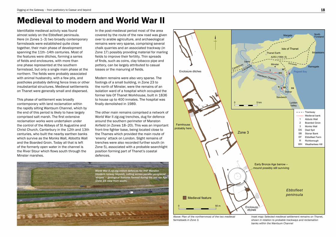
Identifi able medieval activity was found almost solely on the Ebbsfl eet peninsula. Here (in Zones 1–3) two broadly contemporary farmsteads were established quite close together, their main phase of development spanning the 11th–14th centuries. Most of the features were ditches, forming a series of fi elds and enclosures, with more than one phase represented at the southern farmstead, but only a single main phase at the northern. The fi elds were probably associated with animal husbandry, with a few pits, and postholes probably defi ning fence lines or other insubstantial structures. Medieval settlements on Thanet were generally small and dispersed.
This phase of settlement was broadly contemporary with land reclamation within the rapidly silting Wantsum Channel, which by the end of this period is likely to have largely comprised salt marsh. The fi rst extensive reclamation works were undertaken under the control of the Abbeys of St Augustine and Christ Church, Canterbury in the 12th and 13th centuries, who built the nearby earthen banks which survive as the Monks Wall, Abbotts Wall and the Boarded Groin. Today all that is left of the formerly open water in the channel is the River Stour which fl ows south through the Minster marshes.
In the post-medieval period most of the area covered by the route of the new road was given over to arable agriculture, and archaeological remains were very sparse, comprising several chalk quarries and an associated trackway (in Zone 17) possibly providing material for marling fi elds to improve their fertility. Thin spreads of fi nds, such as coins, clay tobacco pipe and pottery, can be largely attributed to casual losses or the manuring of fi elds.
Modern remains were also very sparse. The footings of a small building, in Zone 23 to the north of Minster, were the remains of an isolation ward of a hospital which occupied the former Isle Of Thanet Workhouse, built in 1836 to house up to 400 inmates. The hospital was fi nally demolished in 1989.
The other main remains comprised a network of World War II zig-zag trenches, dug for defence around the southern perimeter of Manston Airfi eld (in Zones 18–20). This was an important front-line fi ghter base, being located close to the Thames which provided the main route of ‘enemy’ attack on London. Slight remains of trenches were also recorded further south (in Zone 5), associated with a probable searchlight position forming part of Thanet’s coastal defences.
World War II zig-zag trench defences for RAF Manston (modern runway beyond), cutting across parallel periglacial ‘stripes’ − geological features formed during the last Ice Age (Zone 19; view from south)
Above: Plan of the northernmost of the two medieval farmsteads in Zone 3.
Inset map: Selected medieval settlement remains on Thanet, shown in relation to probable trackways and reclamation banks within the Wantsum Channel
Medieval to modern and World War IIDigging at the Gateway – from prehistory to Caesar and beyond 18
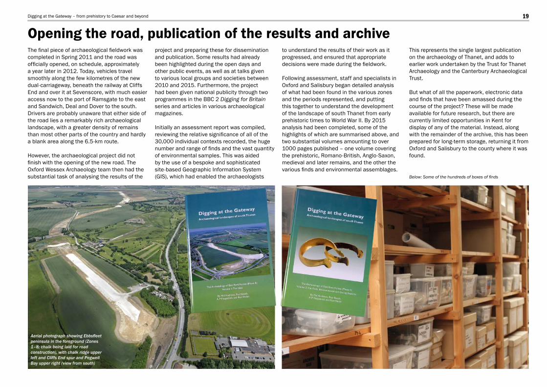
The fi nal piece of archaeological fi eldwork was completed in Spring 2011 and the road was offi cially opened, on schedule, approximately a year later in 2012. Today, vehicles travel smoothly along the few kilometres of the new dual-carriageway, beneath the railway at Cliffs End and over it at Sevenscore, with much easier access now to the port of Ramsgate to the east and Sandwich, Deal and Dover to the south. Drivers are probably unaware that either side of the road lies a remarkably rich archaeological landscape, with a greater density of remains than most other parts of the country and hardly a blank area along the 6.5-km route.
However, the archaeological project did not fi nish with the opening of the new road. The Oxford Wessex Archaeology team then had the substantial task of analysing the results of the
project and preparing these for dissemination and publication. Some results had already been highlighted during the open days and other public events, as well as at talks given to various local groups and societies between 2010 and 2015. Furthermore, the project had been given national publicity through two programmes in the BBC 2 Digging for Britain series and articles in various archaeological magazines.
Initially an assessment report was compiled, reviewing the relative signifi cance of all of the 30,000 individual contexts recorded, the huge number and range of fi nds and the vast quantity of environmental samples. This was aided by the use of a bespoke and sophisticated site-based Geographic Information System (GIS), which had enabled the archaeologists
to understand the results of their work as it progressed, and ensured that appropriate decisions were made during the fi eldwork.
Following assessment, staff and specialists in Oxford and Salisbury began detailed analysis of what had been found in the various zones and the periods represented, and putting this together to understand the development of the landscape of south Thanet from early prehistoric times to World War II. By 2015 analysis had been completed, some of the highlights of which are summarised above, and two substantial volumes amounting to over 1000 pages published – one volume covering the prehistoric, Romano-British, Anglo-Saxon, medieval and later remains, and the other the various fi nds and environmental assemblages.
This represents the single largest publication on the archaeology of Thanet, and adds to earlier work undertaken by the Trust for Thanet Archaeology and the Canterbury Archaeological Trust.
But what of all the paperwork, electronic data and fi nds that have been amassed during the course of the project? These will be made available for future research, but there are currently limited opportunities in Kent for display of any of the material. Instead, along with the remainder of the archive, this has been prepared for long-term storage, returning it from Oxford and Salisbury to the county where it was found.
Aerial photograph showing Ebbsfl eet peninsula in the foreground (Zones 1–8; chalk being laid for road construction), with chalk ridge upper left and Cliffs End spur and Pegwell Bay upper right (view from south)
Below: Some of the hundreds of boxes of fi nds
Opening the road, publication of the results and archiveDigging at the Gateway – from prehistory to Caesar and beyond 19
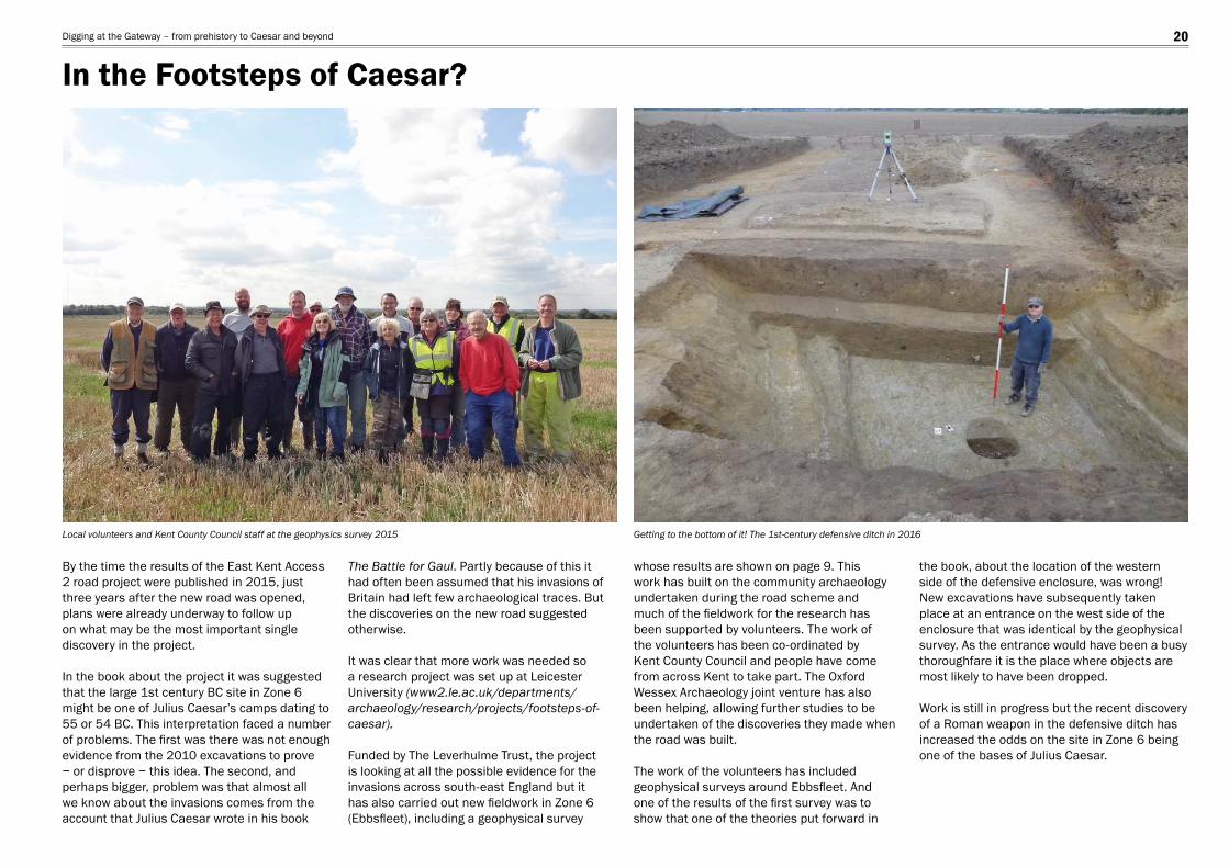
By the time the results of the East Kent Access 2 road project were published in 2015, just three years after the new road was opened, plans were already underway to follow up on what may be the most important single discovery in the project.
In the book about the project it was suggested that the large 1st century BC site in Zone 6 might be one of Julius Caesar’s camps dating to 55 or 54 BC. This interpretation faced a number of problems. The fi rst was there was not enough evidence from the 2010 excavations to prove − or disprove − this idea. The second, and perhaps bigger, problem was that almost all we know about the invasions comes from the account that Julius Caesar wrote in his book
The Battle for Gaul. Partly because of this it had often been assumed that his invasions of Britain had left few archaeological traces. But the discoveries on the new road suggested otherwise.
It was clear that more work was needed so a research project was set up at Leicester University (www2.le.ac.uk/departments/archaeology/research/projects/footsteps-of-caesar).
Funded by The Leverhulme Trust, the project is looking at all the possible evidence for the invasions across south-east England but it has also carried out new fi eldwork in Zone 6 (Ebbsfl eet), including a geophysical survey
whose results are shown on page 9. This work has built on the community archaeology undertaken during the road scheme and much of the fi eldwork for the research has been supported by volunteers. The work of the volunteers has been co-ordinated by Kent County Council and people have come from across Kent to take part. The Oxford Wessex Archaeology joint venture has also been helping, allowing further studies to be undertaken of the discoveries they made when the road was built.
The work of the volunteers has included geophysical surveys around Ebbsfl eet. And one of the results of the fi rst survey was to show that one of the theories put forward in
the book, about the location of the western side of the defensive enclosure, was wrong! New excavations have subsequently taken place at an entrance on the west side of the enclosure that was identical by the geophysical survey. As the entrance would have been a busy thoroughfare it is the place where objects are most likely to have been dropped.
Work is still in progress but the recent discovery of a Roman weapon in the defensive ditch has increased the odds on the site in Zone 6 being one of the bases of Julius Caesar.
Local volunteers and Kent County Council staff at the geophysics survey 2015 Getting to the bottom of it! The 1st-century defensive ditch in 2016
In the Footsteps of Caesar?Digging at the Gateway – from prehistory to Caesar and beyond 20
The publication was generously funded by Kent County Council and Volkerfi tzpatrick Hochtief. We are grateful to Kent County Council Heritage Conservation, Atkins and Jacobs for assistance during the project. We are also grateful to Dr Andrew Fitzpatrick and the Footsteps of Caesar Project team for information. The text was written by Phil Andrews and Andrew Powell, and edited by Philippa Bradley. Illustrations are by Hannah Kennedy (plans and sections), and Elizabeth James and Sophie Lamb (fi nds); fi nds photographs are by Magdalena Wachnik and Karen Nichols. The site plans and sections have been adapted for this publication by Will Foster, who also typeset and designed this report.
The full results of the excavations are published in Digging at the Gateway: Archaeological landscapes of south Thanet. The Archaeology of East Kent Access (Phase II) Volume 1: The Sites and Volume 2: The Finds, Environmental and Dating Reports (Phil Andrews, Paul Booth,A P Fitzpatrick and Ken Welsh 2015 OWA Monograph No. 8).
Aerial photographs are reproduced courtesy of Volkerfi tzpatrick Hochtief; photographs on page 20 are copyright Andrew Fitzpatrick; Iron Age roundhouse image on page 8 David Peter Robinson/Shutterstock.com; all other images are copyright Oxford Wessex Archaeology.
Picture credits
AcknowledgementsDigging at the Gateway – from prehistory to Caesar and beyond 21