Embed Size (px)
DESCRIPTION
http://foothillsri.ca/sites/default/files/null/HLP_2009_10_Prsnttn_HintonShortCourseDay2Part3.pdf
Citation preview

Natural Disturbance Approaches
to Forest Land Management
Day 2, Part 3: Evaluation Techniques
October 6-8, 2009
Hinton, Alberta

On at Least Four Different
Levels:
If there is no single natural pattern
approach, then how to evaluate?
1. Objective
2. The use of NRV
3. Process
4. Success

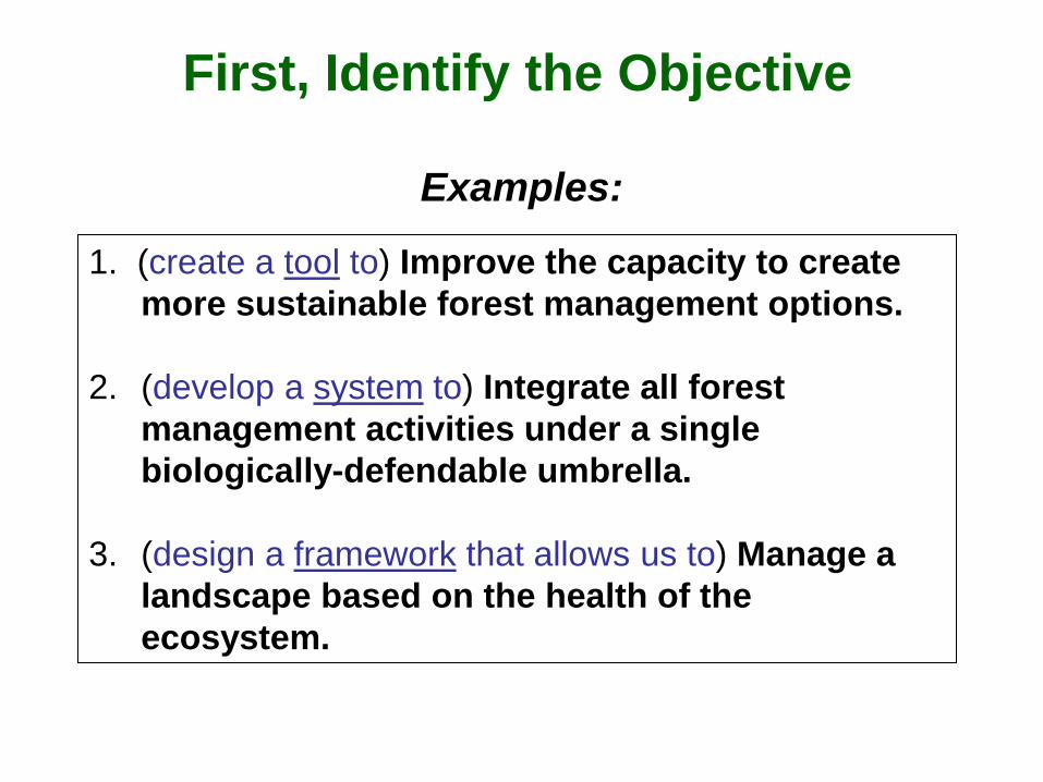
First, Identify the Objective
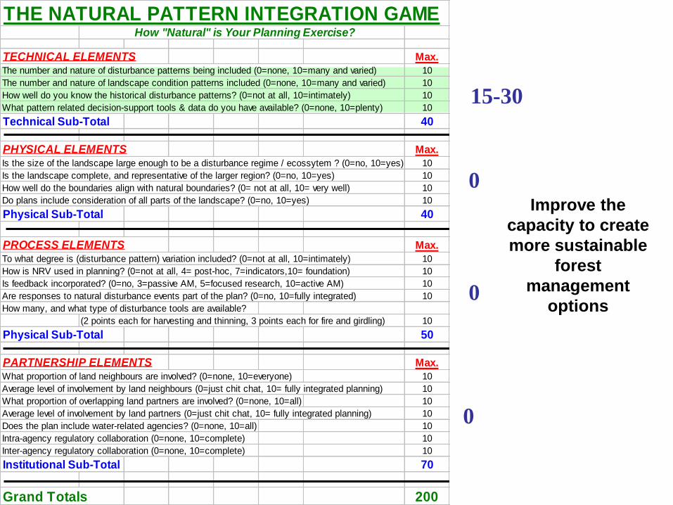
1. (create a tool to) Improve the capacity to create
more sustainable forest management options.
2. (develop a system to) Integrate all forest
management activities under a single
biologically-defendable umbrella.
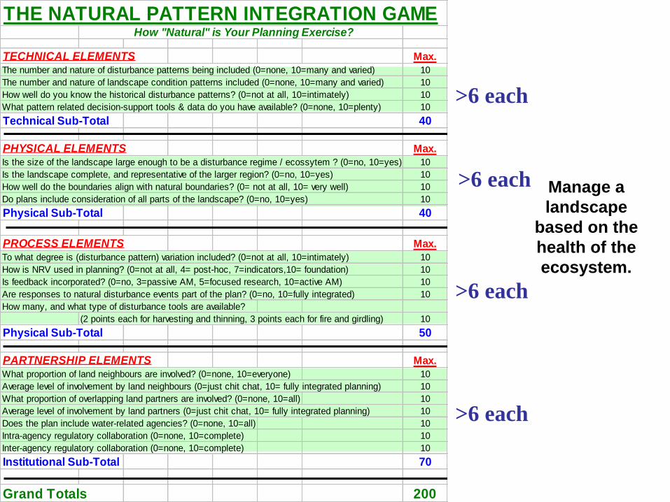
3. (design a framework that allows us to) Manage a
landscape based on the health of the
ecosystem.
Examples:
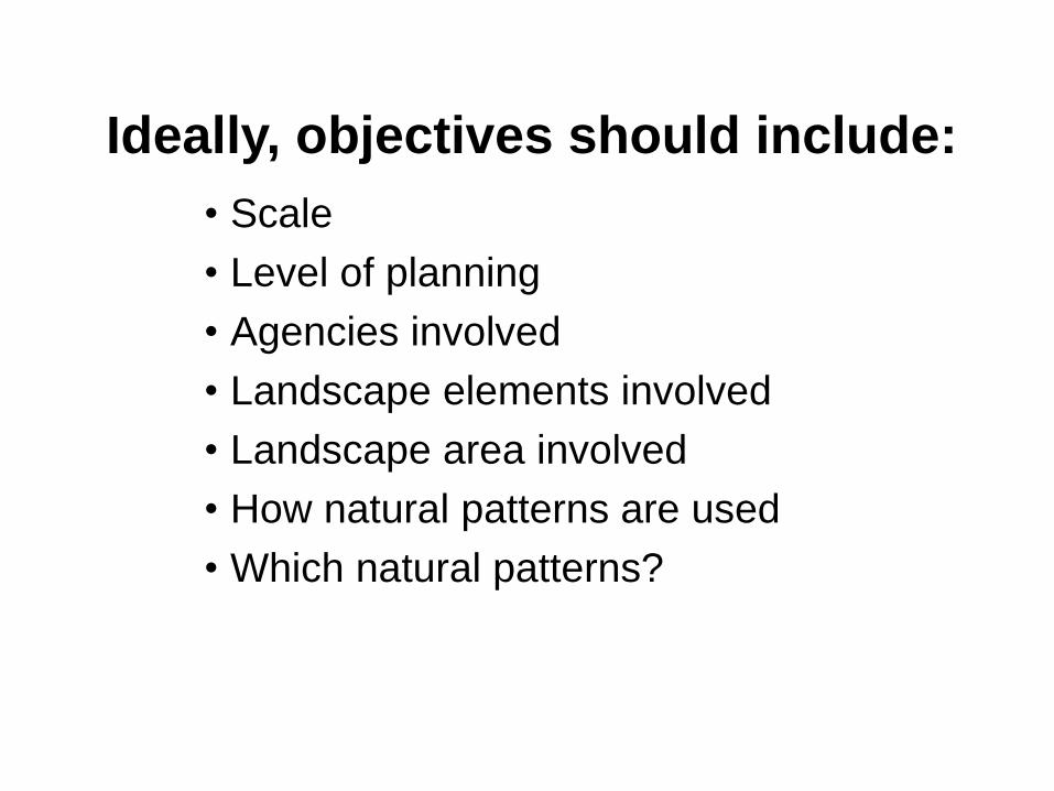
Ideally, objectives should include:
• Scale
• Level of planning
• Agencies involved
• Landscape elements involved
• Landscape area involved
• How natural patterns are used
• Which natural patterns?

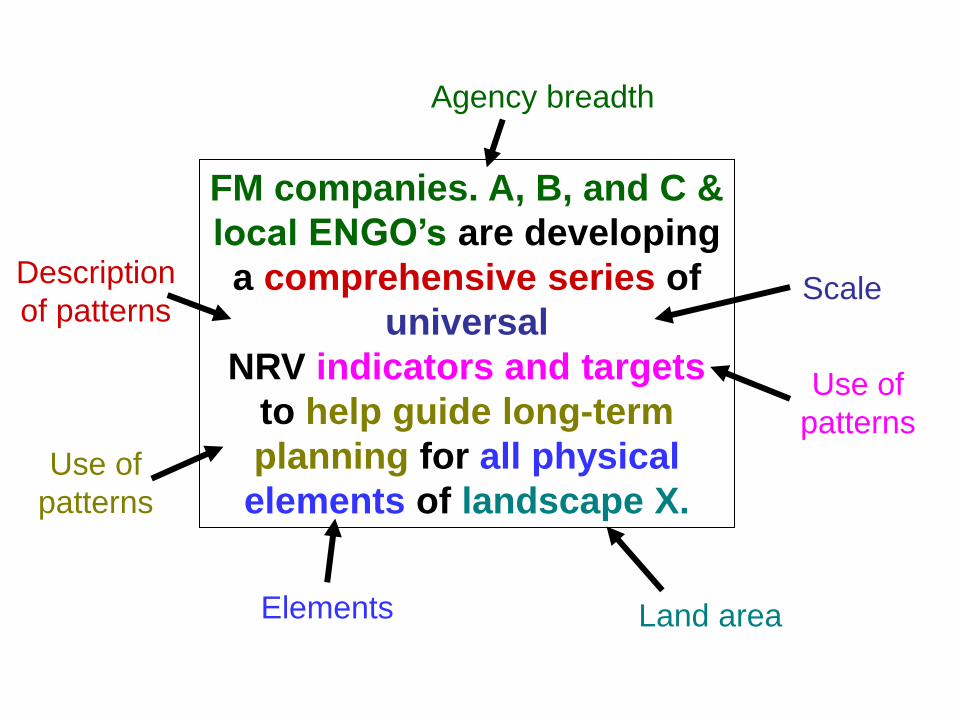
“FM companies. A, B, and C & local
ENGO’s are developing a
comprehensive series of universal NRV
indicators and targets to help guide long-
term planning for all physical elements
of landscape X.”
A good objective statement.
FM companies. A, B, and C &
local ENGO’s are developing
a comprehensive series of
universal
NRV indicators and targets
to help guide long-term
planning for all physical
elements of landscape X.
Agency breadth
Description
of patterns Scale
Use of
patterns
Use of
patterns
Land area Elements
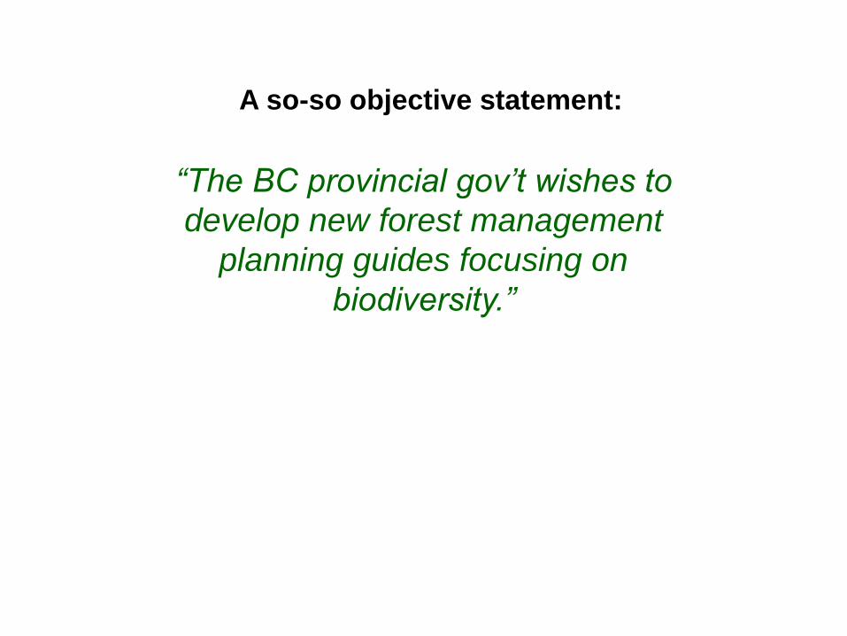
“The BC provincial gov’t wishes to
develop new forest management
planning guides focusing on
biodiversity.”
A so-so objective statement:
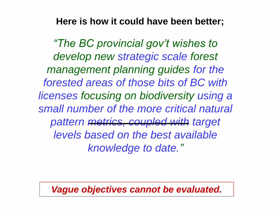
“The BC provincial gov’t wishes to
develop new strategic scale forest
management planning guides for the
forested areas of those bits of BC with
licenses focusing on biodiversity using a
small number of the more critical natural
pattern metrics, coupled with target
levels based on the best available
knowledge to date.”
Here is how it could have been better;
Vague objectives cannot be evaluated.

Technical: Knowledge, tools, & indicators.
Physical: Nature of the landscape & its pieces.
Process: Variation, how NRV is used, feedback,
regulatory issues, integration of natural disturbances,
& available tools.
Partnership: Who is involved, how, and to what
degree.
Elements of an ND Approach
Now, Evaluate Success. Compare Expected to Observed.

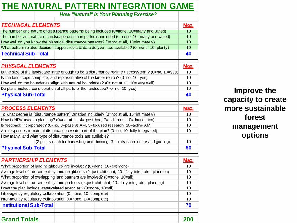
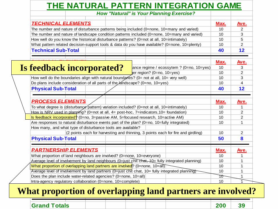
THE NATURAL PATTERN INTEGRATION GAME How "Natural" is Your Planning Exercise?
TECHNICAL ELEMENTS Max. Ave.
The number and nature of disturbance patterns being included (0=none, 10=many and varied) 10 2
The number and nature of landscape condition patterns included (0=none, 10=many and varied) 10 3
How well do you know the historical disturbance patterns? (0=not at all, 10=intimately) 10 5
What pattern related decision-support tools & data do you have available? (0=none, 10=plenty) 10 2
Technical Sub-Total 40 12
PHYSICAL ELEMENTS Max. Ave.
Is the size of the landscape large enough to be a disturbance regime / ecossytem ? (0=no, 10=yes) 10 3
Is the landscape complete, and representative of the larger region? (0=no, 10=yes) 10 2
How well do the boundaries align with natural boundaries? (0= not at all, 10= very well) 10 3
Do plans include consideration of all parts of the landscape? (0=no, 10=yes) 10 4
Physical Sub-Total 40 12
PROCESS ELEMENTS Max. Ave.
To what degree is (disturbance pattern) variation included? (0=not at all, 10=intimately) 10 1
How is NRV used in planning? (0=not at all, 4= post-hoc, 7=indicators,10= foundation) 10 2
Is feedback incorporated? (0=no, 3=passive AM, 5=focused research, 10=active AM) 10 2
Are responses to natural disturbance events part of the plan? (0=no, 10=fully integrated) 10 1
How many, and what type of disturbance tools are available?
(2 points each for harvesting and thinning, 3 points each for fire and girdling) 10 2
Physical Sub-Total 50 8
PARTNERSHIP ELEMENTS Max. Ave.
What proportion of land neighbours are involved? (0=none, 10=everyone) 10 1
Average level of involvement by land neighbours (0=just chit chat, 10= fully integrated planning) 10 1
What proportion of overlapping land partners are involved? (0=none, 10=all) 10 1
Average level of involvement by land partners (0=just chit chat, 10= fully integrated planning) 10 1
Does the plan include water-related agencies? (0=none, 10=all) 10 1
Intra-agency regulatory collaboration (0=none, 10=complete) 10 1
Inter-agency regulatory collaboration (0=none, 10=complete) 10 1
Institutional Sub-Total 70 7
Grand Totals 200 39
First, Identify the Objective
1. (create a tool to) Improve the capacity to create
more sustainable forest management options.
2. (develop a system to) Integrate all forest
management activities under a single
biologically-defendable umbrella.
3. (design a framework that allows us to) Manage a
landscape based on the health of the
ecosystem.
Examples:
Improve the
capacity to create
more sustainable
forest
management
options
THE NATURAL PATTERN INTEGRATION GAME How "Natural" is Your Planning Exercise?
TECHNICAL ELEMENTS Max.
The number and nature of disturbance patterns being included (0=none, 10=many and varied) 10
The number and nature of landscape condition patterns included (0=none, 10=many and varied) 10
How well do you know the historical disturbance patterns? (0=not at all, 10=intimately) 10
What pattern related decision-support tools & data do you have available? (0=none, 10=plenty) 10
Technical Sub-Total 40
PHYSICAL ELEMENTS Max.
Is the size of the landscape large enough to be a disturbance regime / ecossytem ? (0=no, 10=yes) 10
Is the landscape complete, and representative of the larger region? (0=no, 10=yes) 10
How well do the boundaries align with natural boundaries? (0= not at all, 10= very well) 10
Do plans include consideration of all parts of the landscape? (0=no, 10=yes) 10
Physical Sub-Total 40
PROCESS ELEMENTS Max.
To what degree is (disturbance pattern) variation included? (0=not at all, 10=intimately) 10
How is NRV used in planning? (0=not at all, 4= post-hoc, 7=indicators,10= foundation) 10
Is feedback incorporated? (0=no, 3=passive AM, 5=focused research, 10=active AM) 10
Are responses to natural disturbance events part of the plan? (0=no, 10=fully integrated) 10
How many, and what type of disturbance tools are available?
(2 points each for harvesting and thinning, 3 points each for fire and girdling) 10
Physical Sub-Total 50
PARTNERSHIP ELEMENTS Max.
What proportion of land neighbours are involved? (0=none, 10=everyone) 10
Average level of involvement by land neighbours (0=just chit chat, 10= fully integrated planning) 10
What proportion of overlapping land partners are involved? (0=none, 10=all) 10
Average level of involvement by land partners (0=just chit chat, 10= fully integrated planning) 10
Does the plan include water-related agencies? (0=none, 10=all) 10
Intra-agency regulatory collaboration (0=none, 10=complete) 10
Inter-agency regulatory collaboration (0=none, 10=complete) 10
Institutional Sub-Total 70
Grand Totals 200
15-30
0
0
0
THE NATURAL PATTERN INTEGRATION GAME How "Natural" is Your Planning Exercise?
TECHNICAL ELEMENTS Max.
The number and nature of disturbance patterns being included (0=none, 10=many and varied) 10
The number and nature of landscape condition patterns included (0=none, 10=many and varied) 10
How well do you know the historical disturbance patterns? (0=not at all, 10=intimately) 10
What pattern related decision-support tools & data do you have available? (0=none, 10=plenty) 10
Technical Sub-Total 40
PHYSICAL ELEMENTS Max.
Is the size of the landscape large enough to be a disturbance regime / ecossytem ? (0=no, 10=yes) 10
Is the landscape complete, and representative of the larger region? (0=no, 10=yes) 10
How well do the boundaries align with natural boundaries? (0= not at all, 10= very well) 10
Do plans include consideration of all parts of the landscape? (0=no, 10=yes) 10
Physical Sub-Total 40
PROCESS ELEMENTS Max.
To what degree is (disturbance pattern) variation included? (0=not at all, 10=intimately) 10
How is NRV used in planning? (0=not at all, 4= post-hoc, 7=indicators,10= foundation) 10
Is feedback incorporated? (0=no, 3=passive AM, 5=focused research, 10=active AM) 10
Are responses to natural disturbance events part of the plan? (0=no, 10=fully integrated) 10
How many, and what type of disturbance tools are available?
(2 points each for harvesting and thinning, 3 points each for fire and girdling) 10
Physical Sub-Total 50
PARTNERSHIP ELEMENTS Max.
What proportion of land neighbours are involved? (0=none, 10=everyone) 10
Average level of involvement by land neighbours (0=just chit chat, 10= fully integrated planning) 10
What proportion of overlapping land partners are involved? (0=none, 10=all) 10
Average level of involvement by land partners (0=just chit chat, 10= fully integrated planning) 10
Does the plan include water-related agencies? (0=none, 10=all) 10
Intra-agency regulatory collaboration (0=none, 10=complete) 10
Inter-agency regulatory collaboration (0=none, 10=complete) 10
Institutional Sub-Total 70
Grand Totals 200
>20
>10
>10
>5
Integrate all forest
management
activities under a
single biologically-
defendable
umbrella.
THE NATURAL PATTERN INTEGRATION GAME How "Natural" is Your Planning Exercise?
TECHNICAL ELEMENTS Max.
The number and nature of disturbance patterns being included (0=none, 10=many and varied) 10
The number and nature of landscape condition patterns included (0=none, 10=many and varied) 10
How well do you know the historical disturbance patterns? (0=not at all, 10=intimately) 10
What pattern related decision-support tools & data do you have available? (0=none, 10=plenty) 10
Technical Sub-Total 40
PHYSICAL ELEMENTS Max.
Is the size of the landscape large enough to be a disturbance regime / ecossytem ? (0=no, 10=yes) 10
Is the landscape complete, and representative of the larger region? (0=no, 10=yes) 10
How well do the boundaries align with natural boundaries? (0= not at all, 10= very well) 10
Do plans include consideration of all parts of the landscape? (0=no, 10=yes) 10
Physical Sub-Total 40
PROCESS ELEMENTS Max.
To what degree is (disturbance pattern) variation included? (0=not at all, 10=intimately) 10
How is NRV used in planning? (0=not at all, 4= post-hoc, 7=indicators,10= foundation) 10
Is feedback incorporated? (0=no, 3=passive AM, 5=focused research, 10=active AM) 10
Are responses to natural disturbance events part of the plan? (0=no, 10=fully integrated) 10
How many, and what type of disturbance tools are available?
(2 points each for harvesting and thinning, 3 points each for fire and girdling) 10
Physical Sub-Total 50
PARTNERSHIP ELEMENTS Max.
What proportion of land neighbours are involved? (0=none, 10=everyone) 10
Average level of involvement by land neighbours (0=just chit chat, 10= fully integrated planning) 10
What proportion of overlapping land partners are involved? (0=none, 10=all) 10
Average level of involvement by land partners (0=just chit chat, 10= fully integrated planning) 10
Does the plan include water-related agencies? (0=none, 10=all) 10
Intra-agency regulatory collaboration (0=none, 10=complete) 10
Inter-agency regulatory collaboration (0=none, 10=complete) 10
Institutional Sub-Total 70
Grand Totals 200
>6 each
>6 each
>6 each
>6 each
Manage a
landscape
based on the
health of the
ecosystem.

THE NATURAL PATTERN INTEGRATION GAME How "Natural" is Your Planning Exercise?
TECHNICAL ELEMENTS Max. Ave.
The number and nature of disturbance patterns being included (0=none, 10=many and varied) 10 2
The number and nature of landscape condition patterns included (0=none, 10=many and varied) 10 3
How well do you know the historical disturbance patterns? (0=not at all, 10=intimately) 10 5
What pattern related decision-support tools & data do you have available? (0=none, 10=plenty) 10 2
Technical Sub-Total 40 12
PHYSICAL ELEMENTS Max. Ave.
Is the size of the landscape large enough to be a disturbance regime / ecossytem ? (0=no, 10=yes) 10 3
Is the landscape complete, and representative of the larger region? (0=no, 10=yes) 10 2
How well do the boundaries align with natural boundaries? (0= not at all, 10= very well) 10 3
Do plans include consideration of all parts of the landscape? (0=no, 10=yes) 10 4
Physical Sub-Total 40 12
PROCESS ELEMENTS Max. Ave.
To what degree is (disturbance pattern) variation included? (0=not at all, 10=intimately) 10 1
How is NRV used in planning? (0=not at all, 4= post-hoc, 7=indicators,10= foundation) 10 2
Is feedback incorporated? (0=no, 3=passive AM, 5=focused research, 10=active AM) 10 2
Are responses to natural disturbance events part of the plan? (0=no, 10=fully integrated) 10 1
How many, and what type of disturbance tools are available?
(2 points each for harvesting and thinning, 3 points each for fire and girdling) 10 2
Physical Sub-Total 50 8
PARTNERSHIP ELEMENTS Max. Ave.
What proportion of land neighbours are involved? (0=none, 10=everyone) 10 1
Average level of involvement by land neighbours (0=just chit chat, 10= fully integrated planning) 10 1
What proportion of overlapping land partners are involved? (0=none, 10=all) 10 1
Average level of involvement by land partners (0=just chit chat, 10= fully integrated planning) 10 1
Does the plan include water-related agencies? (0=none, 10=all) 10 1
Intra-agency regulatory collaboration (0=none, 10=complete) 10 1
Inter-agency regulatory collaboration (0=none, 10=complete) 10 1
Institutional Sub-Total 70 7
Grand Totals 200 39
The number and nature of disturbance patterns being included.
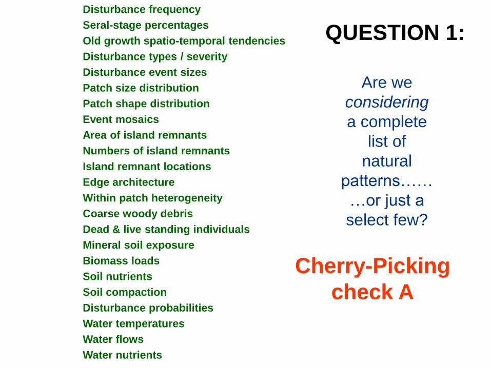
QUESTION 1:
Are we
considering
a complete
list of
natural
patterns……
…or just a
select few?
Disturbance frequency
Seral-stage percentages
Old growth spatio-temporal tendencies
Disturbance types / severity
Disturbance event sizes
Patch size distribution
Patch shape distribution
Event mosaics
Area of island remnants
Numbers of island remnants
Island remnant locations
Edge architecture
Within patch heterogeneity
Coarse woody debris
Dead & live standing individuals
Mineral soil exposure
Biomass loads
Soil nutrients
Soil compaction
Disturbance probabilities
Water temperatures
Water flows
Water nutrients
Cherry-Picking
check A

QUESTION 2:
Are we
considering a
broad spectrum of
indicators, or
many that are
variations on a
single scale, type,
or theme?
Disturbance frequency
Seral-stage percentages
Old growth spatio-temporal tendencies
Disturbance types / severity
Disturbance event sizes
Patch size distribution
Patch shape distribution
Event shape
Total area in residuals
Area of island remnants
Numbers of island remnants
Island remnant locations
Size of island remnants
Number of patches per event
Dead & live standing individuals
Mineral soil exposure
Biomass loads
Soil nutrients
Soil compaction
Disturbance probabilities
Water temperatures
Water flows
Water nutrients
Cherry-Picking
check B

THE NATURAL PATTERN INTEGRATION GAME How "Natural" is Your Planning Exercise?
TECHNICAL ELEMENTS Max. Ave.
The number and nature of disturbance patterns being included (0=none, 10=many and varied) 10 2
The number and nature of landscape condition patterns included (0=none, 10=many and varied) 10 3
How well do you know the historical disturbance patterns? (0=not at all, 10=intimately) 10 5
What pattern related decision-support tools & data do you have available? (0=none, 10=plenty) 10 2
Technical Sub-Total 40 12
PHYSICAL ELEMENTS Max. Ave.
Is the size of the landscape large enough to be a disturbance regime / ecossytem ? (0=no, 10=yes) 10 3
Is the landscape complete, and representative of the larger region? (0=no, 10=yes) 10 2
How well do the boundaries align with natural boundaries? (0= not at all, 10= very well) 10 3
Do plans include consideration of all parts of the landscape? (0=no, 10=yes) 10 4
Physical Sub-Total 40 12
PROCESS ELEMENTS Max. Ave.
To what degree is (disturbance pattern) variation included? (0=not at all, 10=intimately) 10 1
How is NRV used in planning? (0=not at all, 4= post-hoc, 7=indicators,10= foundation) 10 2
Is feedback incorporated? (0=no, 3=passive AM, 5=focused research, 10=active AM) 10 2
Are responses to natural disturbance events part of the plan? (0=no, 10=fully integrated) 10 1
How many, and what type of disturbance tools are available?
(2 points each for harvesting and thinning, 3 points each for fire and girdling) 10 2
Physical Sub-Total 50 8
PARTNERSHIP ELEMENTS Max. Ave.
What proportion of land neighbours are involved? (0=none, 10=everyone) 10 1
Average level of involvement by land neighbours (0=just chit chat, 10= fully integrated planning) 10 1
What proportion of overlapping land partners are involved? (0=none, 10=all) 10 1
Average level of involvement by land partners (0=just chit chat, 10= fully integrated planning) 10 1
Does the plan include water-related agencies? (0=none, 10=all) 10 1
Intra-agency regulatory collaboration (0=none, 10=complete) 10 1
Inter-agency regulatory collaboration (0=none, 10=complete) 10 1
Institutional Sub-Total 70 7
Grand Totals 200 39
To what degree is disturbance pattern variation included?

Are we now, or in the future, staying within “natural range of
variation” benchmarks, at any one point in time?
QUESTION 1:
Red Flag
check
Old Forest %
Time
2000
NRV
2030

Old Forest %
Time
1950
2000
Unknown Territory
Unknown Territory
Are we representing the full range of natural variation over
time? … or just hanging around the bare minimums?
QUESTION 2:
Temporal High-Grade
check
NRV
1%
2%
6%
0% 25%
11%
9%
1%
5%
15%
7%
17%
3%
7%
14%
4%
2%
6%
4% 5% 3%
2%
5%
5%
5%
3%
3%
3% 4%
4%
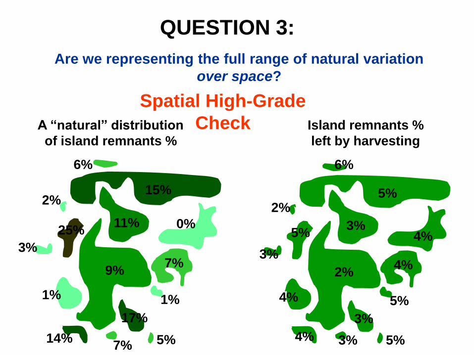
QUESTION 3:
Are we representing the full range of natural variation
over space?
Spatial High-Grade
Check A “natural” distribution
of island remnants %
Island remnants %
left by harvesting
THE NATURAL PATTERN INTEGRATION GAME How "Natural" is Your Planning Exercise?
TECHNICAL ELEMENTS Max. Ave.
The number and nature of disturbance patterns being included (0=none, 10=many and varied) 10 2
The number and nature of landscape condition patterns included (0=none, 10=many and varied) 10 3
How well do you know the historical disturbance patterns? (0=not at all, 10=intimately) 10 5
What pattern related decision-support tools & data do you have available? (0=none, 10=plenty) 10 2
Technical Sub-Total 40 12
PHYSICAL ELEMENTS Max. Ave.
Is the size of the landscape large enough to be a disturbance regime / ecossytem ? (0=no, 10=yes) 10 3
Is the landscape complete, and representative of the larger region? (0=no, 10=yes) 10 2
How well do the boundaries align with natural boundaries? (0= not at all, 10= very well) 10 3
Do plans include consideration of all parts of the landscape? (0=no, 10=yes) 10 4
Physical Sub-Total 40 12
PROCESS ELEMENTS Max. Ave.
To what degree is (disturbance pattern) variation included? (0=not at all, 10=intimately) 10 1
How is NRV used in planning? (0=not at all, 4= post-hoc, 7=indicators,10= foundation) 10 2
Is feedback incorporated? (0=no, 3=passive AM, 5=focused research, 10=active AM) 10 2
Are responses to natural disturbance events part of the plan? (0=no, 10=fully integrated) 10 1
How many, and what type of disturbance tools are available?
(2 points each for harvesting and thinning, 3 points each for fire and girdling) 10 2
Physical Sub-Total 50 8
PARTNERSHIP ELEMENTS Max. Ave.
What proportion of land neighbours are involved? (0=none, 10=everyone) 10 1
Average level of involvement by land neighbours (0=just chit chat, 10= fully integrated planning) 10 1
What proportion of overlapping land partners are involved? (0=none, 10=all) 10 1
Average level of involvement by land partners (0=just chit chat, 10= fully integrated planning) 10 1
Does the plan include water-related agencies? (0=none, 10=all) 10 1
Intra-agency regulatory collaboration (0=none, 10=complete) 10 1
Inter-agency regulatory collaboration (0=none, 10=complete) 10 1
Institutional Sub-Total 70 7
Grand Totals 200 39
Is feedback incorporated?
What proportion of overlapping land partners are involved?
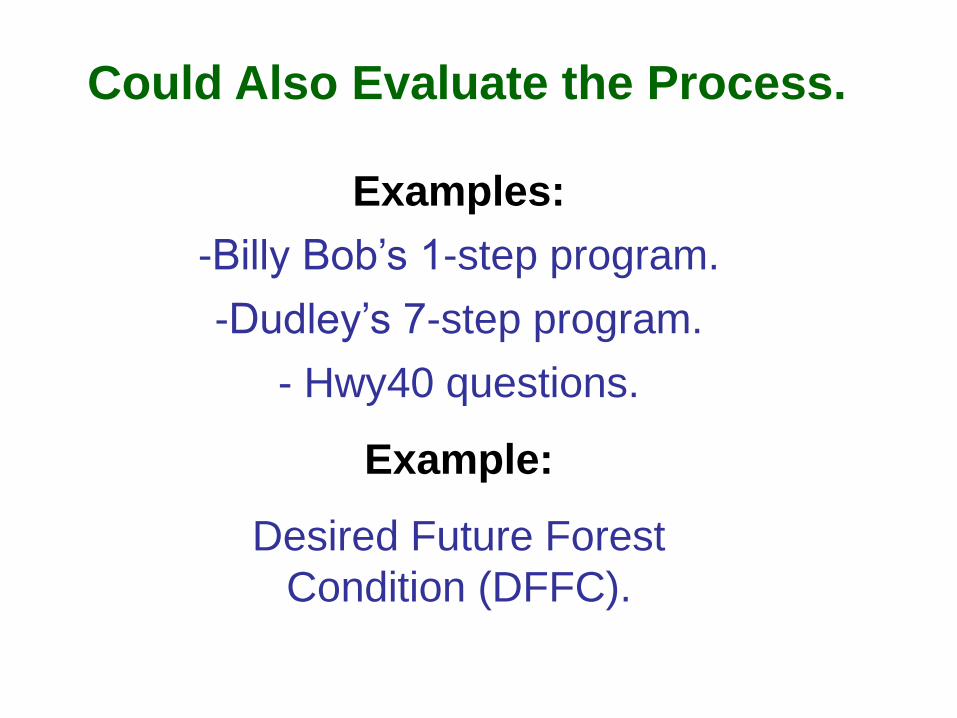
Examples:
-Billy Bob’s 1-step program.
-Dudley’s 7-step program.
- Hwy40 questions.
Example:
Desired Future Forest
Condition (DFFC).
Could Also Evaluate the Process.

Desired Future Forest Condition:
1. What is the natural pattern in question? (NRV)
2. What is the current condition? (CC)
3. What are the (ecological, cultural, economic)
reasons for the differences? (gap analysis)
4. With this in mind, choose a desired future forest
condition (DFFC).
5. Reassess, defend, monitor, and adapt to this
standard.
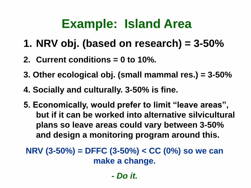
1. NRV obj. (based on research) = 3-50%
2. Current conditions = 0 to 10%.
3. Other ecological obj. (small mammal res.) = 3-50%
4. Socially and culturally. 3-50% is fine.
5. Economically, would prefer to limit “leave areas”,
but if it can be worked into alternative silvicultural
plans so leave areas could vary between 3-50%
and design a monitoring program around this.
Example: Island Area
NRV (3-50%) = DFFC (3-50%) < CC (0%) so we can
make a change.
- Do it.
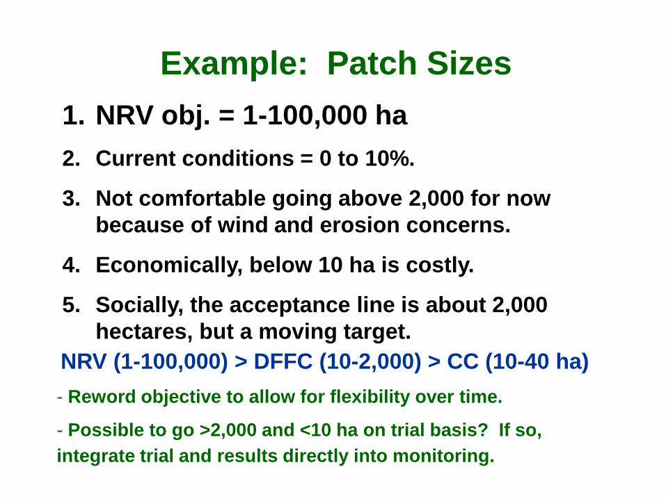
1. NRV obj. = 1-100,000 ha
2. Current conditions = 0 to 10%.
3. Not comfortable going above 2,000 for now
because of wind and erosion concerns.
4. Economically, below 10 ha is costly.
5. Socially, the acceptance line is about 2,000
hectares, but a moving target.
Example: Patch Sizes
NRV (1-100,000) > DFFC (10-2,000) > CC (10-40 ha)
- Reword objective to allow for flexibility over time.
- Possible to go >2,000 and <10 ha on trial basis? If so,
integrate trial and results directly into monitoring.
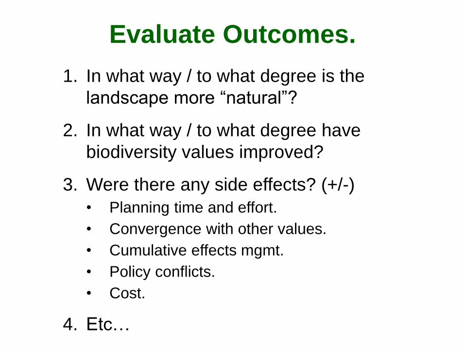
1. In what way / to what degree is the
landscape more “natural”?
2. In what way / to what degree have
biodiversity values improved?
3. Were there any side effects? (+/-)
• Planning time and effort.
• Convergence with other values.
• Cumulative effects mgmt.
• Policy conflicts.
• Cost.
4. Etc…
Evaluate Outcomes.
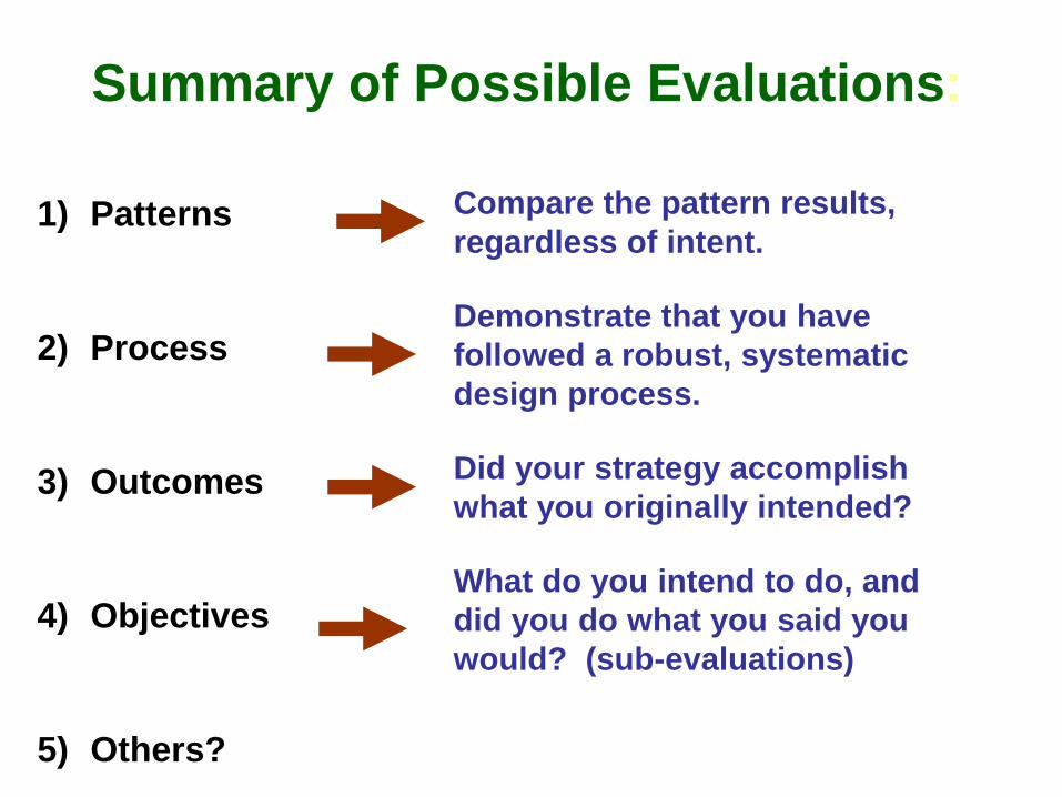
1) Patterns
2) Process
3) Outcomes
4) Objectives
5) Others?
Compare the pattern results,
regardless of intent.
Demonstrate that you have
followed a robust, systematic
design process.
Did your strategy accomplish
what you originally intended?
What do you intend to do, and
did you do what you said you
would? (sub-evaluations)
Summary of Possible Evaluations:

Enough for Day 2?