Embed Size (px)
Citation preview
Historical Perspectives of
Vegetation Communities:
~1700-1900

Work in progress
Started in early 1990s
Questioning popular assumptions, such as…
The Hill Country was originally dominated by
grasslands that have been invaded by woodlands due
to overgrazing/over-browsing and fire suppression
Native Americans burned on a regular basis
Ashe juniper is not native, invasive, etc.
Mural claiming Native Americans routinely set fires on the
Edwards Plateau

“…present-day patterns of vegetation
in the Texas Hill Country have shifted
from rolling hills clothed with tall
grasses. One of the most striking
differences in the landscape is the
large area that now is covered with
dense cedar brakes—extensive stands
of tall shrubs and trees dominated by
Ashe juniper, commonly known as
cedar.”
Claims based on historic accounts, cite
Frederick Law Olmstead (1857).
Example of Using Historic Accounts
to Justify Management Practices

© John Ingram
© John Ingram
© COA BCP staff
© COA BCP staff
© COA BCP staff
© COA BCP staff

• Primary eye-witness accounts (>20)
• Missionaries, prospectors, settlers, scientists, reporters
• Frame of reference/context for accounts:
• Major ecological regions
• Major historic events
• <1700
• 1700-1800
• 1800-1850
• 1850-1900
• Other sources (historic maps, photos, buildings, original
land grants/field survey notes, rare/endangered species
habitat, land use histories)
• Importance of multiple accounts and cross-referencing
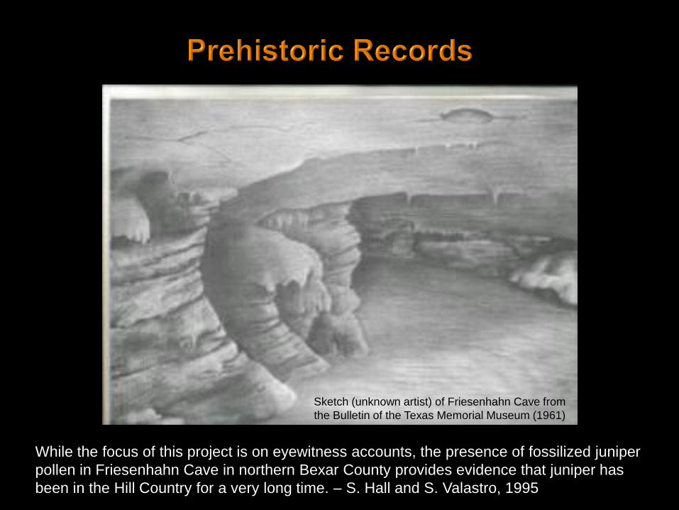
Sketch (unknown artist) of Friesenhahn Cave from
the Bulletin of the Texas Memorial Museum (1961)
While the focus of this project is on eyewitness accounts, the presence of fossilized juniper
pollen in Friesenhahn Cave in northern Bexar County provides evidence that juniper has
been in the Hill Country for a very long time. – S. Hall and S. Valastro, 1995

• Entered historic
accounts into GIS
database
• Need to determine
where each observer
was with respect to
the Balcones
Escarpment – i.e.,
was the observer on
the Blackland Prairie
or in the Hill Country
(hilly portions of the
Edwards Plateau,
Llano Uplift, and
Cross Timbers)
Austin/Travis County

1528 Cabeza de Vaca shipwrecked
off the Galveston coast,
begins first known European
exploration of interior Texas
>1528 Spanish explorers introduce
horses, cattle, sheep, goats,
hogs
>1600 Comanches and other Plains
Indians acquire horses
Cabeza de Vaca’s route, adapted from Krieger (2002: Map 4)
http://www.texasbeyondhistory.net/cabeza-cooking/index.html
No written accounts during this
period, but several significant events
will influence next century
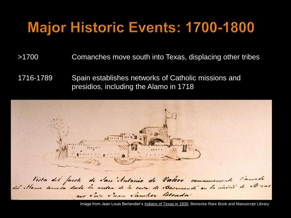
>1700 Comanches move south into Texas, displacing other tribes
1716-1789 Spain establishes networks of Catholic missions and
presidios, including the Alamo in 1718
Image from Jean Louis Berlandier’s Indians of Texas in 1830, Beinecke Rare Book and Manuscript Library

“…we…travelled upstream with a
desire to ford [the Guadalupe
River] or reach its source. We
travelled about three leagues of
very rugged land owing to the
heavy woods and many rocks; and
at the end of the three leagues two
soldiers left for upstream to
reconnoiter the land. They said
that it could not be traveled
because it is more wooded and
contains more rocks….The woods
consist of oaks and junipers….” --Fray Francisco Céliz, 1719
© Photo # CO2164, Austin History Center, Austin Public Library
Approx.
location of
observer
Approx. route of
expedition
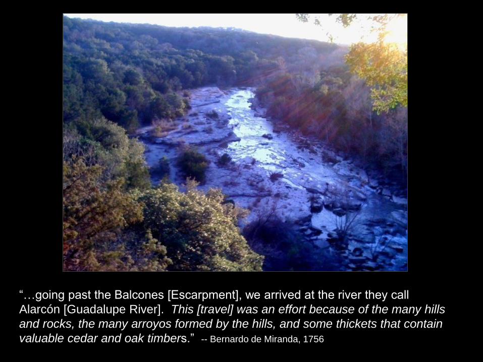
“…going past the Balcones [Escarpment], we arrived at the river they call
Alarcón [Guadalupe River]. This [travel] was an effort because of the many hills
and rocks, the many arroyos formed by the hills, and some thickets that contain
valuable cedar and oak timbers.” -- Bernardo de Miranda, 1756
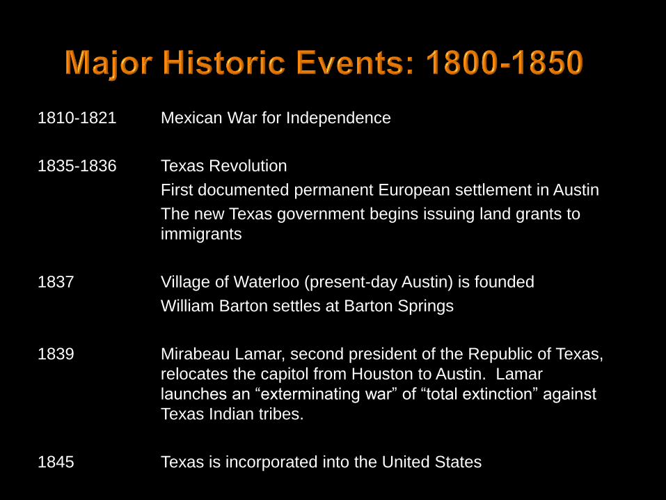
1810-1821 Mexican War for Independence
1835-1836 Texas Revolution
First documented permanent European settlement in Austin
The new Texas government begins issuing land grants to
immigrants
1837 Village of Waterloo (present-day Austin) is founded
William Barton settles at Barton Springs
1839 Mirabeau Lamar, second president of the Republic of Texas,
relocates the capitol from Houston to Austin. Lamar
launches an “exterminating war” of “total extinction” against
Texas Indian tribes.
1845 Texas is incorporated into the United States

“Immediately before us appeared as an extensive lawn with a beautiful green
sward, slightly tinged with the various flowers which decked its surface. Not a
shrub or bush obstructed the monotony except the towering Live Oak…. Further
to the west appeared the skirting timber thickening the further it receded and rising
gradually so that mile after mile of the dark boding forest rose to our view so that
ones imagination or view would be extending to the intricacies of the forest in
search for the curling smoke of the wigwam.” -- W.J. Benedict, 1839
Approx.
location of
observer Approx. route
This account provides a good example of an observer reporting
“grass as far as the eye can see.” It’s critical to note that he was
describing the Blackland Prairie. We need to keep reading for his
description of the Hill Country (here described as mile after mile of
“dark boding forest”).

“On the left bank of Comal Creek there is well forested bottom land which
extends to the cedar, oak, and elm covered cliffs which here already have
considerable height. Beyond this there is a high ridge with summits here and
there similar to our Black Forest.”
“From its confluence with the Comal Creek I, with four companions, attempted
to reach the head spring. However, having covered only five miles after hours
of chopping through underbrush and heavy forest, we had to return without
success.”
“…I ascended the ridge on horseback, forcing a path
through the heavy cedar thickets and using the
outcropping ledges as steps. The view from the high
ridge, behind which there is a plateau several miles
wide, is enchanting. I rode three or four miles into
this tableland without coming to its end.”
-- Prince Carl of Solms-Braunfels, 1845
Portrait (unknown artist) of
Prince Carl of Solms-Braunfels

“The cedars here are not the
stunted shrub-like plants found in
the Northern States of the Union,
but are stately trees with straight
trunks, seldom more than twenty to
twenty-five feet in height and one
and one-half feet thick. They have
a uniformly spreading crown….”
“This cedar forest is a treasure to
the colonists of New Braunfels,
since the wood was preferred
above all others on account of its
durability when used in building
houses and fences.”
– F. Roemer, 1849
Large Ashe juniper on
Balcones Canyonlands
Preserve, estimated to be
several hundred years old

“The road [between New Braunfels and San Antonio] led us over an open,
undulating prairie of great fertility. A cedar-covered slope, similar to that at New
Braunfels, was at our right for the first ten miles, which farther on flattened out
into a low lying chain of hills.” – F. Roemer, 1849
“The hills which extend all the way from Austin to New Braunfels, are covered
with heavy timber.” – V. Bracht, 1849
Approximate route
between Austin and
San Antonio along
what is today the
I35 corridor

Blackland Prairie Edwards Plateau
Original Land Grants
Travis County, TX
Field survey notes for William Barton’s Property, 1838; recorded 1 elm, 1 hackberry, 5 cedars,
1 Spanish oak, and 1 live oak (“witness trees”) near Barton Springs

1854 Two Indian reservations established in West-Central Texas
1859 Indians on the Texas reservations moved to reservations in Oklahoma
1861-1865 Civil War
1868 First patent granted for barbed wire
1871 First train arrives in Austin
1872 Yellowstone established as first national park
1875 Last free band of Comanches surrenders and moves to Fort Sill Reservation in Oklahoma
1878 Huston-Tillotson opens
1883 UT Austin opens
1888 Completion of Texas State Capitol
1889 Survey reports 25 bison remaining in
the Texas panhandle
1893 Completion of first Colorado River dam
1894 Oil discovered in Texas
1900 Last records of passenger pigeons in
Texas. U.S. wild bison population
drops to fewer than 40 animals.
>1900 Continued expansion of livestock
industries on the Edwards Plateau

“We rode [from Austin] to the Brushy Creek, 20 miles [near Cedar Park], and encamped for the night. Our road was for about 14 miles of the way over a rich rolling prairie and for about six miles through a heavy cedar brake. Cedar is the main reliance for rail timber in this section, the live oak being too gnarled for such purposes.” -- A. S. Johnston, 1855
Approx.
location of
observer

“I have visited Austin for the first time…The surrounding country is quite
beautiful…dark, steep, cedar-covered mountains rise about five miles north of the
city.” -- V. Bracht, 1849
“The country on [Barton] creek presents an extensive range of cedar hills and is
much broken.” – J. De Cordova, 1858
Photo taken from Texas Capitol Dome shortly
after it was built, looking southwest
© Photo #PICA19238, Austin History Center,
Austin Public Library
Note artist’s rendering of forest (textured)
and prairie (flat)
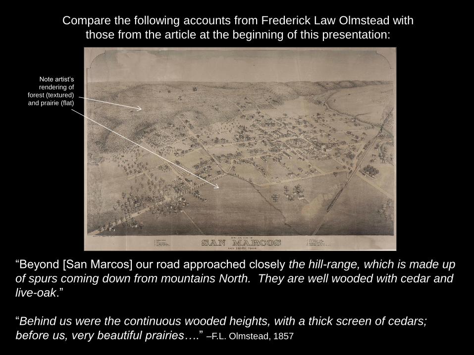
“Beyond [San Marcos] our road approached closely the hill-range, which is made up
of spurs coming down from mountains North. They are well wooded with cedar and
live-oak.”
“Behind us were the continuous wooded heights, with a thick screen of cedars;
before us, very beautiful prairies….” –F.L. Olmstead, 1857
Compare the following accounts from Frederick Law Olmstead with
those from the article at the beginning of this presentation:
Note artist’s
rendering of
forest (textured)
and prairie (flat)

“Wild lands [in Travis County] may be purchased at very low rates. The cost of improvements is a serious item; but when a cedar fence is once put round a plantation it will need but little repair for many years. With vast prairies, we have also cedar lands at intervals seldom exceeding five miles, and these can be purchased at a small price. The planter finds a cedar lot of indispensable value, from the abundant material for improvements with which it furnishes him.” -- J. De Cordova, 1858
Our fences are chiefly made of cedar-rails, from the cedar-brake above Austin. – S.J. Wood, 1861
Blackland Prairie Edwards Plateau
Original Land Grants
Travis County, TX

“…the mountains…are covered with cedar, and send clear crystal waters gushing
from them….” –J. de Cordova, 1858
© Photo #CO1827, Austin History Center, Austin Public Library
Bull Creek, near confluence with Colorado River, looking north/northwest (circa early 1900s)

“I am getting a little afraid the sheep will take the mountains in four or five years
more…. Sheep is mighty hard on the range. You can tell a sheep range before you
get in two or three miles of the house, for they keep the grass eaten off plum in the
ground….” – E. Burrowes, 1860
© Photo #C02101, Austin History Center, Austin Public Library
Cedar cabin on what is today RM 2222, looking west with Bull Creek in background (circa early 1900s)

Distribution of sheep and goats in Texas
(Texas Crop and Livestock Reporting Service 1994)
“About one fourth of [Travis] county is mountainous or hilly, the land rather poor and rocky, but well watered, and some of it covered with cedar and others kinds of timber. It is well adapted to the raising of horses, cattle, sheep, and goats. The balance of the county is gently rolling prairie or level prairie and river-bottom….” -- S.J. Wood, 1861
Photo of Angora goat herd on what is today part of the Balcones Canyonlands Preserve
© Photo #PICB12552, Austin History Center, Austin Public Library

“The cedar tie business has contributed largely to the growth and prosperity of
the ‘Hill City’ in the last two years, more especially the last twelve months. A
gentleman connected with the Central Railroad says that two hundred thousand
cedar ties have been shipped from this city during the last two years, and when
it is remembered that these ties bring from sixty to ninety cents each, the reader
will readily comprehend the vastness of the revenue from this source….” –Austin Daily Democratic Statesman, September 10, 1874
© Austin History Center, Austin Public Library

[Golden-cheeked Warblers] are nowhere abundant, and only to be met with in
the thickest cedar brakes, and as these are fast being cut and burnt out, the
bird will no doubt become still more rare.” – H.P. Attwater, 1892
© Gil Eckrich
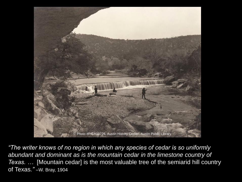
“The writer knows of no region in which any species of cedar is so uniformly
abundant and dominant as is the mountain cedar in the limestone country of
Texas. … [Mountain cedar] is the most valuable tree of the semiarid hill country
of Texas.” –W. Bray, 1904
© Photo #PICA19726, Austin History Center, Austin Public Library
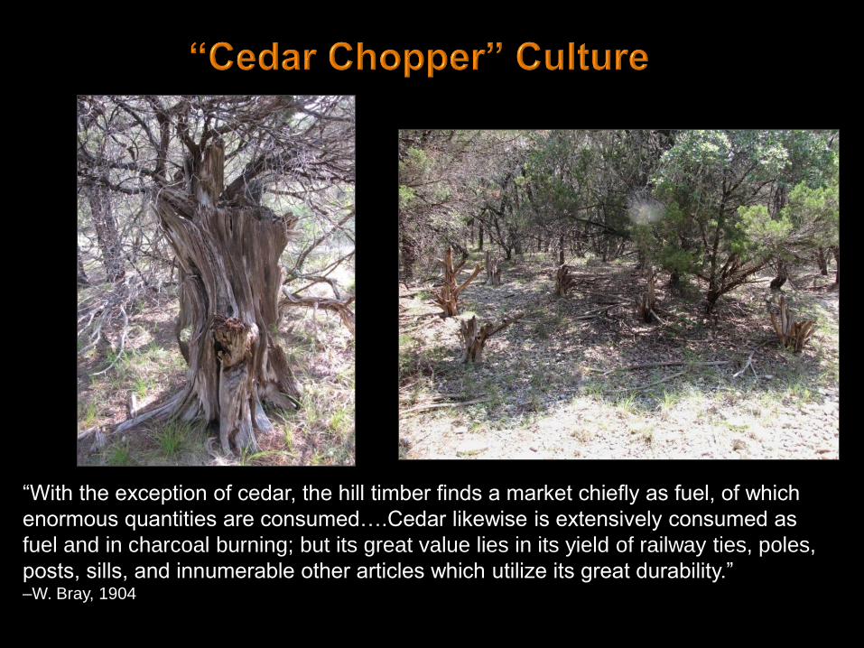
“With the exception of cedar, the hill timber finds a market chiefly as fuel, of which
enormous quantities are consumed….Cedar likewise is extensively consumed as
fuel and in charcoal burning; but its great value lies in its yield of railway ties, poles,
posts, sills, and innumerable other articles which utilize its great durability.” –W. Bray, 1904

“The cedar eradication program was greatly accelerated as a result of the
invention of a new type of axe [‘Kerrville Cedar Axe’] especially suited for cutting
cedar trees and cedar brush. The cedar axe is a product of the Hill Country in
Texas, where armies of cedar choppers have been swinging away for over thirty
years. It was invented partly by accident and partly because of a real need for a
better tool to do the job.” –G. Hollon, 1946
From Hollon (1946) with permission from Texas State Historical Association

“A deplorable loss of cedar has
taken place from brake fires. For
half a century these have
periodically occurred; areas which
have not been burned over are
the exception. Every old settler
can tell of big fires which burned
for days. In July, 1901, a very
disastrous fire occurred near
Marble Falls, in which about 600
acres of valuable cedar were
destroyed” -- W. Bray, 1904
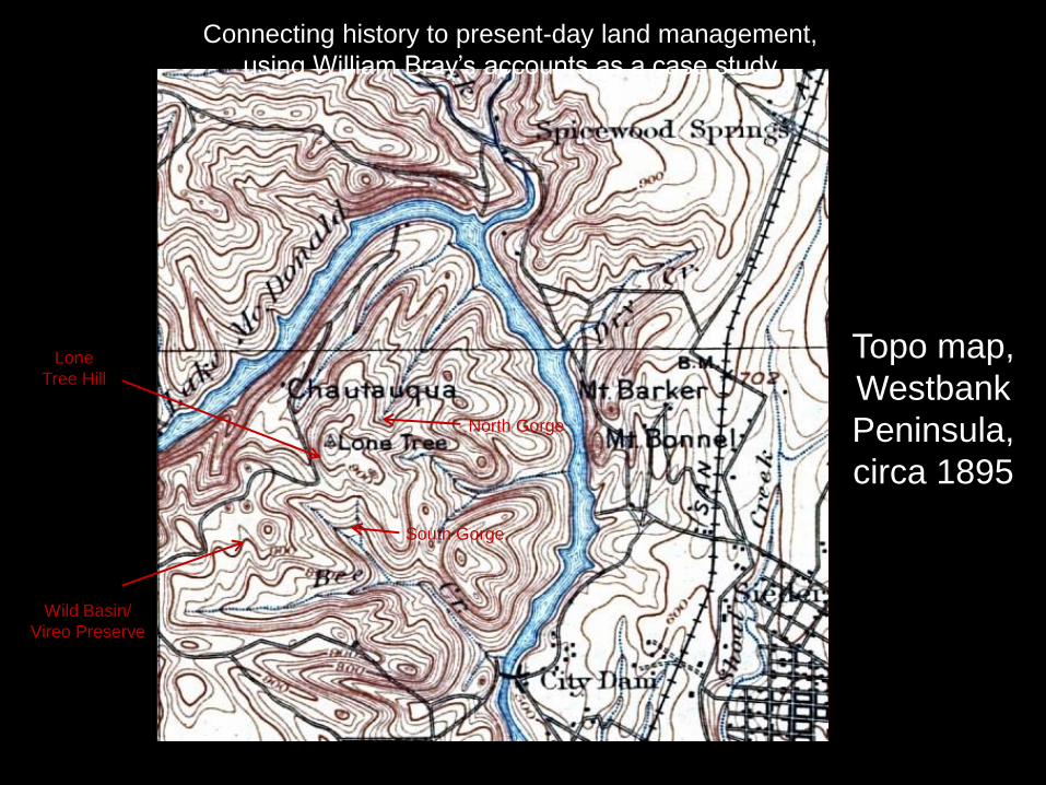
Topo map,
Westbank
Peninsula,
circa 1895
Lone
Tree Hill
Wild Basin/
Vireo Preserve
Connecting history to present-day land management,
using William Bray’s accounts as a case study
North Gorge
South Gorge

“’North Gorge’ from Lone Tree Hill” described as having “almost impenetrable
growth of cedar and mixed timber” and a “deep layer of rich soil.” -- William Bray
1904
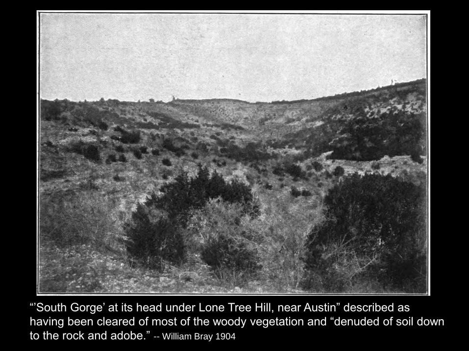
“’South Gorge’ at its head under Lone Tree Hill, near Austin” described as
having been cleared of most of the woody vegetation and “denuded of soil down
to the rock and adobe.” -- William Bray 1904

Bray (1904) compared the North Gorge and South Gorge
photos to illustrate the effects of forests on soils and on the
behavior of rainfall and runoff.
He made several points, including:
• Forests build soil
• Forests protect soil from erosion, keep it cool and moist
• Forest soils act as a sponge and promote recharge
He concluded: “For all these reasons, forests tend to
conserve the water supply and to maintain full springs and an
even flow of streams.”
William Bray believed the woodlands of the Edwards Plateau
were critical to protecting water supplies downstream and
advocated for their protection.
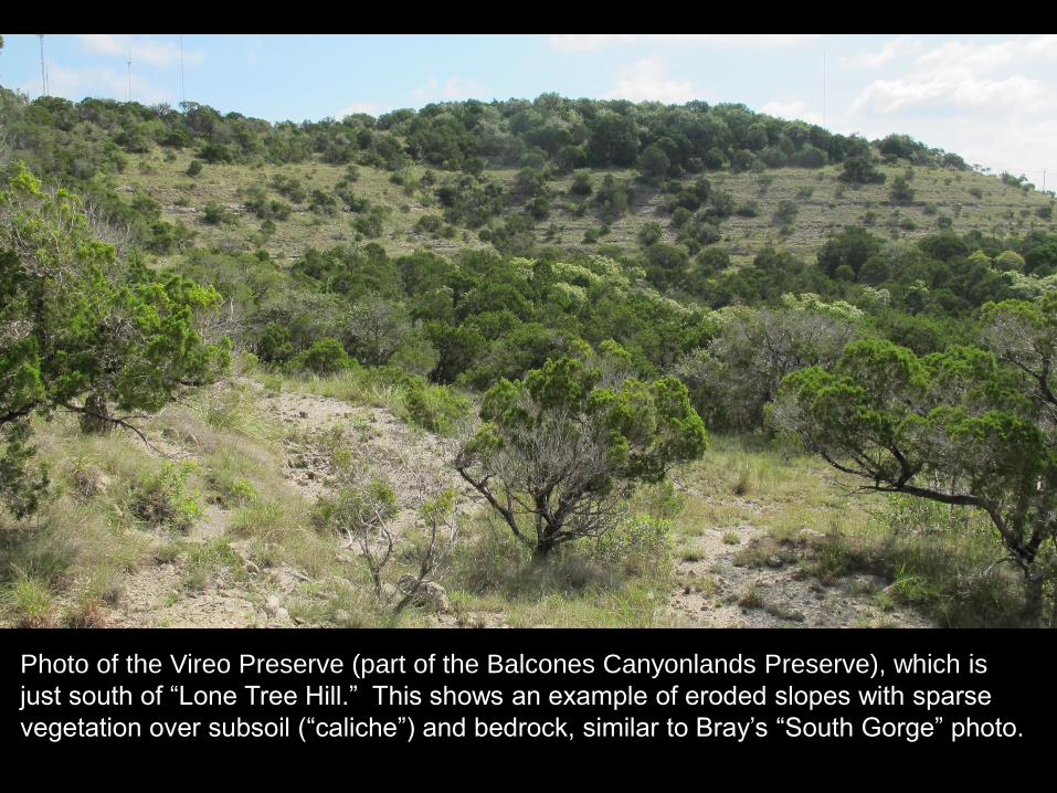
Photo of the Vireo Preserve (part of the Balcones Canyonlands Preserve), which is
just south of “Lone Tree Hill.” This shows an example of eroded slopes with sparse
vegetation over subsoil (“caliche”) and bedrock, similar to Bray’s “South Gorge” photo.
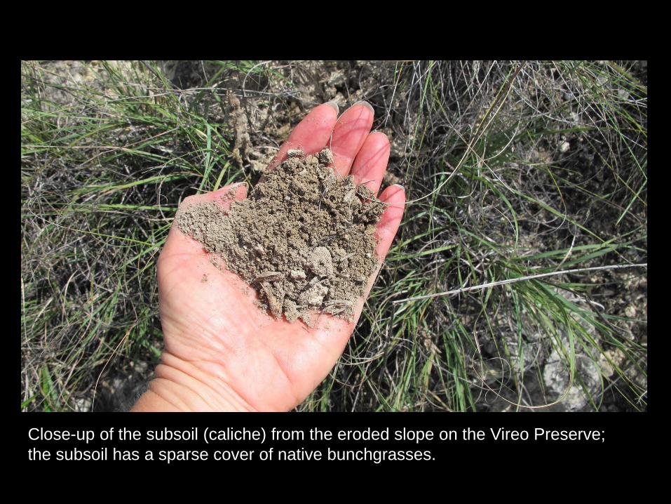
Close-up of the subsoil (caliche) from the eroded slope on the Vireo Preserve;
the subsoil has a sparse cover of native bunchgrasses.
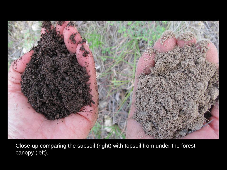
Close-up comparing the subsoil (right) with topsoil from under the forest
canopy (left).

Close-up of typical vegetation from the eroded slope on the Vireo Preserve
surrounded by bare caliche and bedrock. However, note the bunchgrasses and
woody species under the juniper canopy.

Another example of bunchgrasses and woody species under the juniper canopy
(juniper mottes).

• Given our knowledge of land use history, we are working
to restore topsoils in areas within the Balcones
Canyonlands Preserve where they have been lost due to
erosion following land clearing.
• As part of our restoration efforts, we are collecting
baseline data on soils.
• The following graph compares soil organic carbon from
under the native bunchgrasses growing over the subsoil
and from under the juniper mottes (shown in previous
slides).

0.00
2.00
4.00
6.00
8.00
10.00
12.00
Bunchgrasses Juniper Motte
So
il O
rga
nic
Ca
rbo
n (
%)
Soil Organic Carbon Vireo Preserve
Balcones Canyonlands Preserve
Soils under the juniper mottes have over 5 times the amount of organic
carbon as the surrounding subsoils

Carbon is critical to soil function and productivity, and is a
key component of and contributor to healthy soils.
Soils high in organic matter can hold more water, which
means they both capture and store more rainfall while
reducing runoff and the resulting flooding.
High carbon soils are less vulnerable to erosion and are
more resistant to drought.
They store and supply nutrients and so have better fertility
and are less likely to lose nutrients through leaching.
Soil management plays a critical role in whether the
carbon remains in the soil or is released to the
atmosphere.
Why soil organic carbon is important (the following is
drawn from NRCS webpages and other sources):

• The following slide shows soil organic carbon data for
another tract within the Balcones Canyonlands
Preserve (Sam Hamilton West).
• The SHW tract is relatively flat and so still has about a
foot of topsoil.
• The area has been cleared several times in the past
and includes open areas, young juniper woodlands,
and a few old junipers.

0.00
2.00
4.00
6.00
8.00
10.00
12.00
14.00
16.00
Open Young Junipers Old Junipers
So
il O
rga
nic
Ca
rbo
n (
%)
Soil Organic Carbon San Hamilton West Tract
Balcones Canyonlands Preserve
Levels of soil organic carbon increase with increasing woodland stand age
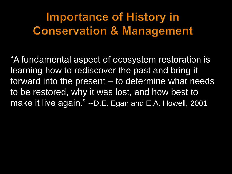
“A fundamental aspect of ecosystem restoration is
learning how to rediscover the past and bring it
forward into the present – to determine what needs
to be restored, why it was lost, and how best to
make it live again.” --D.E. Egan and E.A. Howell, 2001

William Willard Ashe
(1872-1932)
1892-1905 – Forester, North Carolina Geological Survey
1905–1932 – U.S. Forest Service
1918-1924 - Secretary of the National Forest Reservation Commission
© The University of North Carolina
Chapel Hill Herbarium
Ashe juniper was not
formally described until
1930, by John
Buccholz, and was
named in honor of
William Ashe
Any Questions?
© Gil Eckrich

Attwater, H.P. 1892. List of birds observed in the vicinity of San Antonio, Bexar County, Texas. The Auk 9(4):337-
345.
Benedict, W.J. 1839. Diary of a campaign against the Comanches. The Southwestern Historical Quarterly (1929)
32:300-310.
Berlandier, J.L. 1830. The Indians of Texas in 1830. Edited and introduced by J.C. Ewers, translated by P.R.
Leclercq in Smithsonian Publication 4745 (1969). Smithsonian Institution Press, Washington D.C.
Bracht, Viktor. 1849. Texas in 1848. Translated by Charles Frank Schmidt. Naylor Printing Company, San Antonio,
Texas.
Bray, William L. 1904. The timber of the Edwards Plateau of Texas: its relation to climate, water supply, and soil.
U.S. Department of Agriculture, Bureau of Forestry – Bulletin No. 49. Government Printing Office, Washington.
Buchholz, J.T. 1930. The ozark white cedar. Botanical Gazette 90:326-332.
Burrowes, Edward. 1860. Letters in “New Jersey Pioneers in Texas”, by Charles M. Snyder (1961). Southwestern
Historical Quarterly 64(3):348-368.
Céliz, Fray Francisco. 1719. Diary of the Alarcón expedition into Texas, 1718-1719. Translated by Fritz Leo
Hoffman, in The Quivera Society (1935). Los Angeles, CA.
De Cordova, J. 1858. Texas: her resources and her public men. J.B. Lippincott & Co. Philadelphia, PA.

Egan, D. and E. Howell (editors). 2001. The historical ecology handbook: a restorationist’s guide to reference
ecosystems. Island Press, Washington, D.C.
Evans, G.L. and G.E. Meade. 1961. Bulletin of the Texas Memorial Museum Number 2 (Part 1 The Friesenhahn
Cave). Museum of the University of Texas. Austin, TX.
Hall, S. and S. Valastro. 1995. Grassland vegetation in the southern Great Plains during the last glacial maximum.
Quaternary Research 44:237-245.
Hollon, Gene. 1946. Kerrville cedar axe. Southwestern Historical Quarterly 50(2):241-250.
Johnston, Albert Sidney. 1855. With Albert Sidney Johnston in West Texas: Austin to Fort Chadbourne, March 1855.
Edited by Marilyn McAdams Sibley, in West Texas Historical Association Year Book (October, 1964). West Texas
Historical Association, Abilene, TX.
Krieger, A. 2002. We Came Naked and Barefoot: The Journey of Cabeza de Vaca across North America. Edited by
Margery Krieger. University of Texas Press, Austin, TX.
Miranda, Bernardo de. 1756. Miranda’s inspection of Los Almagres: his journal report, and petition. Edited and
translated by Roderick B. Patten, in Southwestern Historical Quarterly (October, 1970):74(2):223-251.
Olmstead, F. 1857. A journey through Texas; or, a saddle-trip on the southwestern frontier: with a statistical
appendix. Dix, Edwards & Co., New York, NY.

Roemer, Ferdinand. 1849. Texas with particular reference to German immigration and the physical appearance of
the country. Translated by Oswald Mueller (1995). Eakin Press, Austin, TX.
Solms, Prince of. 1845. Prince Solm’s 10th report dated 27 March, 1845 on Comal Creek. Compiled and edited by
Chester William and Ethel Hander Geue in A New Land Beckoned: German Immigration to Texas, 1844-1847 (1972).
Texian Press, Waco, TX.
Wood, S.J. 1861. Travis County: the Texas Almanac for 1861, with statistics, historical and biographical sketches
relating to Texas. W. & D. Richardson, Galveston, TX.