Embed Size (px)
Citation preview


i
Highway Functional Classification: Concepts, Criteria and Procedures
ii
TABLE OF CONTENTS
Section 1. Introduction ..................................................................................................... 1
1.1 Overview ......................................................................................................... 2
Section 2. Concepts ......................................................................................................... 4 2.1 Introduction .................................................................................................... 4 2.2 Functional Classification Concepts ............................................................... 4
2.2.1 Access versus Mobility ......................................................................... 4 2.3 Other Important Factors Related to Functional Classification .................. 7 2.4 System Continuity ......................................................................................... 11
Section 3. Criteria............................................................................................................ 14 3.1 Definitions and Characteristics ................................................................... 14
3.1.1 Interstates ........................................................................................... 14 3.1.2 Other Freeways & Expressways ........................................................ 14 3.1.3 Other Principal Arterials .................................................................... 15 3.1.4 Minor Arterials .................................................................................... 15 3.1.5 Major and Minor Collectors .............................................................. 16 3.1.6 Local Roads .......................................................................................... 17
3.2 Putting it all Together .................................................................................. 18 3.3 A Real World Example ................................................................................. 19 3.4 Final Considerations ...................................................................................... 21
Section 4. Procedures ..................................................................................................... 25 4.1 Introduction .................................................................................................. 25 4.2 Identifying the Functional Classification of a Roadway Network ........... 25
4.2.1 Arterial Considerations ..................................................................... 27 4.2.2 Collector Considerations ................................................................... 28 4.2.3 General Rules of Thumb for All Categories and the System as a
Whole .................................................................................................. 28 4.3 Good Practices............................................................................................... 29
4.3.1 Ongoing Maintenance of the Functional Classification System ... 29 4.4 Geographic Information Systems ................................................................ 32
4.4.1 Proactive Communication and Accessibility of Information ........ 33 4.5 Partners in the Functional Classification Process ..................................... 33
4.5.1 Metropolitan Planning Organizations ............................................. 33 4.5.2 State DOTs .......................................................................................... 34 4.5.3 Counties and Other Agencies ........................................................... 34
4.6 Suggested Procedural Tasks ........................................................................ 34
Section 5. Applications .................................................................................................. 40 5.1 Performance ..................................................................................................40 5.2 Data Needs and Reporting ...........................................................................40
5.2.1 Impact of Functional Classification Changes ..................................40 5.3 Secondary Functional Classification Uses ..................................................40 5.4 Highway Design ............................................................................................ 41

Highway Functional Classification: Concepts, Criteria and Procedures
iii
5.4.1 The Relationship between Functional Classification and Design . 41 5.4.1.1 AASHTO Green Book and Flexibility in Highway Design 42 5.4.1.2 Livability ............................................................................... 42 5.4.1.3 Smart Transportation Guidebook ...................................... 43 5.4.1.4 CSS in Designing Major Urban Thoroughfares for
Walkable Communities ....................................................... 44 5.5 Assessment of Functional Classification Systems ..................................... 45 5.6 Emerging/Other Functional Classification Systems ................................. 45 5.7 Future Trends ................................................................................................48
Section 6. Urban Boundaries ........................................................................................ 49 6.1 Introduction ................................................................................................. 49 6.2 Defining Urban and Rural ............................................................................ 50
6.2.1 Census Definitions ............................................................................. 50 6.2.2 FHWA Definitions ........................................................................... 501
6.3 Relationship to Functional Classification ................................................... 52 6.4 Developing Adjusted Urban Area Boundaries ........................................... 53
6.4.1 Adjusted Urban Area Boundaries – Technical Tasks ..................... 53 6.4.2 Consideration Factors for Adjusting Urban Areas .......................... 54
6.5 Adjusted Urban Area Boundaries – Procedural Tasks .............................. 58 6.5.1 Risk Factors to Urban Area Adjustment Schedule ......................... 58 6.5.2 Urban Area Adjustment Schedule .................................................... 59
6.6 Adjusted Urban Area Boundaries – Data Transmittal Requirements ..... 62
Section 7. Graphics Sources ...........................................................................................63

Highway Functional Classification: Concepts, Criteria and Procedures
iv
LIST OF TABLES
Table 2-1: Relationship between Functional Classification and Travel Characteristics ............................................................................................ 11
Table 3-1: Characteristics of Urban and Rural Arterials .............................................. 15 Table 3-2: Characteristics of Urban and Rural Minor Arterials ................................. 16 Table 3-3: Characteristics of Major and Minor Collectors (Urban and Rural) ......... 17 Table 3-4: Characteristics of Urban and Rural Local Roads ....................................... 18 Table 3-5: VMT and Mileage Guidelines by Functional Classifications - Arterials .. 22 Table 3-6: VMT and Mileage Guidelines by Functional Classifications – Collectors
and Locals .................................................................................................. 23 Table 4-1: Example Massaschusetts Roadway Functional Classification Table ........38 Table 4-2: Key Milestones for Development and Submittal of the Functional
Classification Network ............................................................................. 39 Table 5-1: Oregon DOT’s Classification System .......................................................... 45 Table 6-1: US Census Bureau Urban Area Types Defined by Population Range ...... 51 Table 6-2: FHWA Urban Area Types Defined by Population Range ......................... 51 Table 6-3: Key Milestones for Development and Submittal of Adjusted Urban Area
Boundaries ................................................................................................ 62 Table 6-4: Geospatial Database Required Attributes ................................................. 62
LIST OF FIGURES
Figure 1-1: Principal Arterial - Other Freeways & Expressways ................................... 2 Figure 1-2: HOV Lane on Interstate 95 in Woodbridge, VA ........................................ 3 Figure 1-3: Other Principal Arterial in California .......................................................... 3 Figure 2-1: Aerial View of the Eisenhower (and Johnson) Tunnels along I-70, west
of Denver, CO .............................................................................................. 5 Figure 2-2: View from Inside the Eisenhower Tunnel .................................................. 5 Figure 2-3: Aerial View of Eisenhower Court, North Platte, NE .................................. 5 Figure 2-4: Aerial View of Eisenhower Street in Carrolton, TX ................................. 6 Figure 2-5: Illustration of Access-Mobility Dynamic ................................................... 6 Figure 2-6: Collector Example ......................................................................................... 7 Figure 2-7: Example of Access Points ............................................................................. 7 Figure 2-8: Functional Classification Map of Giddings, TX and Surrounding
Unincorporated Territory ......................................................................... 10 Figure 2-9: Schematic Illustrating the Concept of Continuity ................................... 12 Figure 2-10: Example of an Exception to the Connectivity Guidelines, Wings Neck
Road, Bourne, MA ..................................................................................... 12 Figure 2-11: Example of an Interstate Spur Terminating at a City Street in Holyoke,
MA .............................................................................................................. 13 Figure 3-1: Example of Interstate ................................................................................... 14 Figure 3-2: Example of Other Principal Arterial ......................................................... 15 Figure 3-3: Example of Urban Minor Arterial ............................................................. 15

Highway Functional Classification: Concepts, Criteria and Procedures
v
Figure 3-4: Federal Functional Classification Decision Tree ...................................... 18 Figure 3-5: Map of an Urban Area’s Roadway Network .............................................. 19 Figure 3-6: Map of a Rural Area’s Roadway Network .................................................. 19 Figure 3-7: Worcester, MA Roadway System .............................................................. 20 Figure 3-8: Classification Overlap ................................................................................. 21 Figure 4-1: Minnesota DOT Functional Classification Change Request Form ......... 31 Figure 4-2: Example of Shifting due to Inconsistency between Tabular Event Data
and Geospatial Data .................................................................................. 32 Figure 4-3 Sample Roadway Color Scheme .................................................................. 33 Figure 4-4: Good-Practice Timeframe for Functional Classification Updates in
Months ....................................................................................................... 35 Figure 5-1: “Table 5.1 Roadway Categories” from the Smart Transportation
Guidebook, March 2008 ........................................................................... 43 Figure 5-2: Community Arterial Roadway Design Guidelines in Smart
Transportation Guidebook ...................................................................... 44 Figure 5-3: Idaho DOT’s Proposed Redefinition of Functional Street Classifications
.................................................................................................................... 47 Figure 5-4: ITE Report: Context Sensitive Solutions in Designing Major Urban
Thoroughfares for Walkable Communities ........................................... 47 Figure 6-1: Prototypical Urban and Rural Areas ......................................................... 50 Figure 6-2: Example of Roadway Coinciding with Adjusted Urban Area ................. 53 Figure 6-3: 2000 Census Urban Cluster and Urbanized Areas (Ohio and Vicinity) 54 Figure 6-4: Example Original Urban Area.................................................................... 55 Figure 6-5: Example Single Contiguous Area ............................................................... 55 Figure 6-6: Example Area Expanded to Cover Air Force Base .................................. 56 Figure 6-7: Example Area Expanded to Include Industrial Area .............................. 56 Figure 6-8: Example Boundary Adjusted to Align with Major Roadway .................. 57 Figure 6-9: Example Boundary Adjusted for Simplicity ............................................. 57 Figure 6-10: Good Practice Level of Procedural Steps for an Urban Boundary
Update Process ......................................................................................... 59

1
SECTION 1. INTRODUCTION
The Highway Functional Classification: Concepts, Criteria and Procedures, 2013 Edition, describes the procedures and processes for assigning functional classifications to roadways and adjusting urban area boundaries. This document builds upon and modifies prior guidance documents.
Our nation’s roadway system is a vast network that connects places and people within and across national borders. Planners and engineers have developed elements of this network with particular travel objectives in mind. These objectives range from serving long-distance passenger and freight needs to serving neighborhood travel from residential developments to nearby shopping centers. The functional classification of roadways defines the role each element of the roadway network plays in serving these travel needs.
Over the years, functional classification has come to assume additional significance beyond its purpose as a framework for identifying the particular role of a roadway in moving vehicles through a network of highways. Functional classification carries with it expectations about roadway design, including its speed, capacity and relationship to existing and future land use development. Federal legislation continues to use functional classification in determining eligibility for funding under the Federal-aid program. Transportation agencies describe roadway system performance, benchmarks and targets by functional classification. As agencies continue to move towards a more performance-based management approach, functional classification will be an increasingly important consideration in setting expectations and measuring outcomes for preservation, mobility and safety.
As a result of the decennial census, the US Census Bureau issues urban area boundary maps. Transportation agencies should review these census boundaries and either accept them as is or adjust them for transportation planning purposes.
This guidance document provides recommended practices for assigning functional classifications and adjusting urban area boundaries concerning roadways that Federal, State and local transportation entities own and operate. Assigning functional classifications and adjusting urban area boundaries requires work elements common to many large-scale business enterprises: there are technical methods and tools to create an efficient and cost-effective end product; there are also procedural elements that require coordination and negotiation across agencies and individuals. This guidance document encompasses both of these elements.
This guidance document also recognizes and describes the implications of how our roadway systems are configured, used and planned for today:
The Federal-aid system has matured significantly. A significant proportion of new functional classification designations are likely to occur from improvements and modifications to existing roads and corridors, rather than from designations on new roadways and corridors.
Highway Functional Classification: Concepts, Criteria and Procedures
2
In conducting functional classification updates, State departments of transportation (DOTs) strive for consensus with potentially dozens of agencies, including metropolitan and rural planning agencies, local officials and FHWA Division Offices.
Geospatial technologies and travel demand forecasting capabilities have advanced significantly, greatly lowering the cost of data storage and increasing analysis capabilities.
Planners and engineers have expanded roadway design options significantly, especially in areas where providing for non-motorized travel is a priority. Transportation agencies have developed their own classification terms to describe these options.
1.1 Overview This guidance document builds upon and updates the two most recent guidance documents circulated by FHWA, namely:
Highway Functional Classification: Concepts, Criteria and Procedures, March 1989
Updated Guidance for the Functional Classification of Highways Memorandum, October 14, 20081
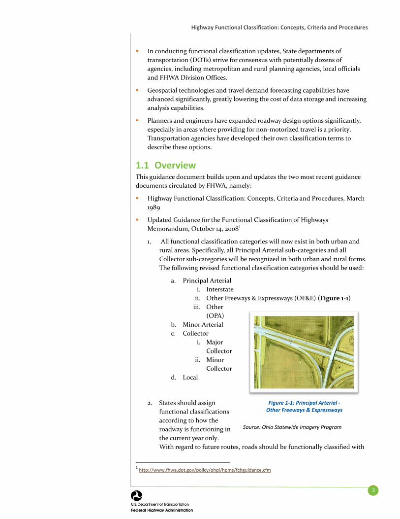
1. All functional classification categories will now exist in both urban and rural areas. Specifically, all Principal Arterial sub-categories and all Collector sub-categories will be recognized in both urban and rural forms. The following revised functional classification categories should be used:
a. Principal Arterial i. Interstate
ii. Other Freeways & Expressways (OF&E) (Figure 1-1) iii. Other
(OPA) b. Minor Arterial c. Collector
i. Major Collector
ii. Minor Collector
d. Local
2. States should assign functional classifications according to how the roadway is functioning in the current year only. With regard to future routes, roads should be functionally classified with
1 http://www.fhwa.dot.gov/policy/ohpi/hpms/fchguidance.cfm
Figure 1-1: Principal Arterial - Other Freeways & Expressways
Source: Ohio Statewide Imagery Program

Highway Functional Classification: Concepts, Criteria and Procedures
3
the existing system if they are included in an approved Statewide Transportation Improvement Program (STIP) and are expected to be under construction within the STIP timeframe of 4 years or less. Use the current classification for roadways, even replacement roadways that will upgrade the roadway, until construction is complete. Reclassify the new roadway once it has been constructed.
3. Ramps and other non-mainline roadways are to be assigned the same functional classification as the highest functional classification among the connecting mainline roadways served by the ramp. (Figure 1-2)
4. Principal Arterial roadways (Figure 1-3) serve a large percentage of travel between cities and other activity centers, especially when minimizing travel time and distance is important. For this reason, Arterials typically are roadways with high traffic volumes and are frequently the route of choice for intercity buses and trucks. The spacing of Arterials in urban areas is closely related to the trip-end density characteristics of activity centers in urban areas. The spacing of these facilities (in larger urban areas) may vary from less than 1 mile in highly developed central business areas to 5 miles or more in the sparsely developed urban fringes.
Figure 1-3: Other Principal Arterial in California
Source: Akos Szoboszlay
Principal Arterials play a unique role in providing a high degree of mobility and carrying a high proportion of travel for long distance trips. These facilities carry the major portion of trips entering and leaving an activity center, as well as the majority of through movements that either go directly through or bypass the area.
Roadways that fall into the Principal Arterials- Other Freeways & Expressways category are limited-access roadways that serve travel in a similar way to the Interstates.
Transportation agencies apply a variety of treatments to preserve mobility and increase the person throughput of Urban Arterials, including ramp metering, high-occupancy-vehicle (HOV) lanes and high-occupancy toll lanes.
Figure 1-2: HOV Lane on Interstate 95 in Woodbridge, VA
Source: www.roadstothefuture.com

4
SECTION 2. CONCEPTS
2.1 Introduction This section of the guidance document presents the concepts underlying the functional classification of roadways. It first introduces the two primary transportation functions of roadways, namely mobility and access, and describes where different categories of roadways fall within a continuum of mobility-access. In addition to mobility and access, other factors that can help determine the proper category to which a particular roadway belongs — such as trip length, speed limit, volume, and vehicle mix — are discussed in this section.
While Arterials, Collectors and Locals span the full range of roadway functions, the Federal functional classification scheme uses additional classification categories to describe these functions more precisely. Distinctions between access-controlled and full-access roadways; the urban and rural development pattern; and subtleties between “major” and “minor” sub-classifications are key considerations when determining the Federal functional classification category to which a particular roadway belongs. The process of determining the correct functional classification of a particular roadway is as much art as it is science. Therefore, a real-world example is presented to help make the discussion of functional classification more readily understood.
2.2 Functional Classification Concepts Most travel occurs through a network of interdependent roadways, with each roadway segment moving traffic through the system towards destinations. The concept of functional classification defines the role that a particular roadway segment plays in serving this flow of traffic through the network. Roadways are assigned to one of several possible functional classifications within a hierarchy according to the character of travel service each roadway provides. Planners and engineers use this hierarchy of roadways to properly channel transportation movements through a highway network efficiently and cost effectively.
2.2.1 Access versus Mobility Roadways serve two primary travel needs: access to/egress from specific locations and travel mobility. While these two functions lie at opposite ends of the continuum of roadway function, most roads provide some combination of each.
Roadway mobility function: Provides few opportunities for entry and exit and therefore low travel friction from vehicle access/egress
Roadway accessibility function: Provides many opportunities for entry and exit, which creates potentially higher friction from vehicle access/egress
The flow of traffic throughout a roadway network is similar to the flow of blood through the human circulatory system or the trunk and branch system of a tree. The units moving through the system (blood cells, nutrients, vehicles, etc.) move through progressively smaller network elements as they approach their destination.

Highway Functional Classification: Concepts, Criteria and Procedures
5
These two roles can be best understood by examining two extreme examples (Figure 2-1 and Figure 2-2).
First, consider the Eisenhower Tunnel west of Denver, CO. Located along Interstate 70, the Eisenhower Tunnel runs under the Continental Divide in the Rocky Mountains and is one of the longest tunnels in the United States. Motorists that travel through the tunnel are en route to a distant location and are using the roadway completely to serve their “mobility” needs. There is no location that is immediately “accessible” to the roadway.
Next, consider the example of Eisenhower Court in North Platte, NE (Figure 2-3). This roadway is travelled almost exclusively by the individuals that live along the roadway. Hence, the roadway entirely provides “accessibility” and offers almost nothing in terms of mobility.
Figure 2-4 depicts the neighborhood around Eisenhower Street in Carrollton, TX. This roadway serves both mobility needs (the residents that live along the side streets that intersect Eisenhower Street use it for some level of north/south mobility) and land access needs (there are both residential and commercial properties located along the roadway).
Figure 2-3: Aerial View of Eisenhower Court, North Platte, NE
Source: Google Earth Pro, June 27, 2012
Figure 2-1: Aerial View of the Eisenhower (and Johnson) Tunnels along I-70, west of Denver, CO
Source: Google Earth Pro, June 27, 2012
Figure 2-2: View from Inside the Eisenhower Tunnel
Source: Creative Commons Attribution-Share Alike 2.0
generic license; Benjamin Clark

Highway Functional Classification: Concepts, Criteria and Procedures
6
Figure 2-4: Aerial View of Eisenhower Street in Carrollton, TX
Source: Google Earth Pro, June 28, 2012
For nomenclature purposes, those roadways that provide a high level of mobility are called “Arterials”; those that provide a high level of accessibility are called “Locals”; and those that provide a more balanced blend of mobility and access are called “Collectors.”
The relationship between mobility and land access is illustrated in Figure 2-5. Arterials provide mostly mobility; Locals provide mostly land access; and Collectors strike a balance between the two. Context Sensitivity and Livability form the environment through which Mobility and Access should be considered. These concepts are discussed in greater detail in Chapter 5.
While most roadways offer both “access to property” and “travel mobility” services, it is the roadway’s primary purpose that defines the classification category to which a given roadway belongs.2
2 The use of the term “Local” roadway in the context of functional classification is separate from the use of the term in a jurisdictional context. While it is true that roadways functionally classified as “Local” are often under the jurisdiction of a “local” entity (i.e., incorporated city), Local Roads are not always under local jurisdiction. Other roadway classifications, including Arterials, may also be under the jurisdiction of a local (i.e., non-state) entity.
Figure 2-5: Illustration of Access-Mobility Dynamic
Source: FHWA

Highway Functional Classification: Concepts, Criteria and Procedures
7
2.3 Other Important Factors Related to Functional Classification
The distinction between “mobility and accessibility” is important in assigning functional classifications to roadways. There are a few additional factors to consider, and these are discussed here.
Efficiency of Travel: Trip makers will typically seek out roadways that allow them to travel to their destinations with as little delay as possible and by the shortest travel time. Arterial roadways provide this kind of service, often in the form of fully or partially controlled access highways, with no or very few intersecting roadways to hinder traffic flow. Therefore, a high percentage of the length of a long-distance trip will be made on Arterials. In contrast, travelers making shorter trips tend to use Local and/or Collector roadways for a much higher proportion of the trip length than Arterial roads.
Collectors: As their name implies, Collectors “collect” traffic from Local Roads and connect traffic to Arterial roadways. Collector routes are typically shorter than Arterial routes but longer than Local Roads. Collectors often provide traffic circulation within residential neighborhoods as well as commercial, industrial or civic districts (see Figure 2-6).
Access Points: Arterials primarily serve long-distance travel and are typically designed as either access controlled or partially access controlled facilities with limited locations at which vehicles can enter or exit the roadway (typically via on- or off-ramps). In instances where limited or partial access control is not provided, signalized intersections are used to control traffic flow, with the Arterial given the majority of the green time.
In growing urban areas, Arterial roadways often experience an ever-increasing number of driveway access points. This high degree of accessibility decreases mobility. To address this issue and restore the carrying capacity of through traffic on these roadways, transportation agencies apply access management principles, such as driveway consolidation and median installations (see Figure 2-7).
In contrast, roadways classified as “Local” provide direct access to multiple properties.
A route is a linear path of connected roadway segments, all with the same functional classification designation. For example, the roadways along a given Arterial route may — and often do — comprise multiple named roadways or state numbered facilities. Similarly, different segments of a given named roadway, or even more likely a given state numbered route, may belong to different functional classification categories, depending on the character of travel service that each segment provides. In the example to the right, the minor Arterial “route” consists of a portion of Tyler Street and a portion of Dalton Avenue (shown in green). East of Dalton Avenue, Tyler Street (shown in brown) is a Minor Collector.
Figure 2-6: Collector Example
Source: CDM Smith
Figure 2-7: Example of Access Points
Source: Ohio DOT, http://www.ahtd.info/basic_bike-
f

Highway Functional Classification: Concepts, Criteria and Procedures
8
Speed Limit: In general, there is a relationship between posted speed limits and functional classification. Arterials typically have higher posted speed limits as vehicles encounter few or no at-grade intersections. The absence of cross-traffic and driveways allows for higher rates of speed, which provides mobility, especially for long-distance travel. In contrast, because their primary role is to provide access, Locals are lined with intersecting access points in the form of driveways, intersecting roadways, cross walks and transfer points for buses and other modes. Due to the frequency of traffic turns, speed limits are kept low to promote safe traffic operations. Speed limits on any non-access controlled roadways are also influenced by the mix of vehicles and modes that use them.
Route Spacing: Directly related to the concept of channelization of traffic throughout a network is the concept of distance (or spacing) between routes. For a variety of reasons, it is not feasible to provide Arterial facilities to accommodate every possible trip in the most direct manner possible or in the shortest amount of time. Ideally, regular and logical spacing between routes of different classifications exists. Arterials are typically spaced at greater intervals than Collectors, which are spaced at much greater intervals than Locals. This spacing varies considerably for different areas; in densely populated urban areas, spacing of all routes types is smaller and generally more consistent than the spacing in sparsely developed rural areas. Geographic barriers greatly influence the layout and spacing of roadways.
Usage (Annual Average Daily Traffic [AADT] Volumes and Vehicle Miles of Travel [VMT]): Arterials serve a high share of longer distance trips and daily vehicle miles of travel. In rural areas, Arterials typically account for approximately half of the daily vehicle miles of travel; in urban areas, this percentage is often higher. Collectors account for the next largest percentage of travel. Urban Area Collectors account for somewhat less (5 to 15 percent), while the percentage for Rural Area Collectors is typically in the 20 to 30 percent range. Lastly, by definition, Local Roads in rural areas typically serve very low density, dispersed developments with relatively low traffic volume. In contrast, the Urban Local Road network, with higher roadway centerline miles and higher density spacing, serves denser land uses and therefore accounts for a larger proportion of travel than its rural counterpart.
While there is a general relationship between the functional classification of a roadway and its annual average daily traffic volume, two roads that carry the same traffic volume may actually serve very different purposes and therefore have different functional classifications. Conversely, two roadways in different parts of a State may have the same functional classification but carry very different traffic volumes. This is particularly applicable among urban areas with very different populations — an Arterial within a remote city with a population of 50,000 is likely to have a much lower traffic volume than an Arterial within a city of 1 million people.
Traffic volumes, however, can come into play when determining the proper functional classification of a roadway “on the border” of a functional classification group (for example, trying to determine whether a roadway should be classified as a Collector or Local). Furthermore, AADT can often be used as a “tie-breaker” when trying to determine which of two (or more) similar and roughly parallel roadways should be classified with a higher (or lower) classification than the other. For example, suppose that two parallel roadways appear to serve the
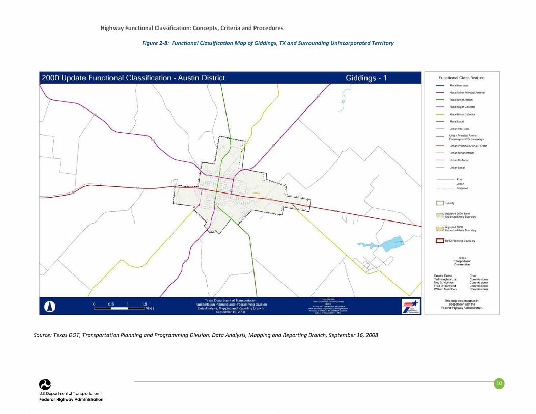
When determining the functional classification of a given roadway, no single factor should be considered alone. For example, US 290 runs through the heart of Giddings, TX. Within the city, the roadway has many intersecting roadways, provides direct access to a number of densely developed commercial and residential properties and has speed limits as low as 35 mph. However, because the roadway is one of the two most direct routes of travel between Austin and Houston and a large percentage of its traffic consists of longer distance trips, the roadway is best classified as an Arterial.

Highway Functional Classification: Concepts, Criteria and Procedures
9
function of a Collector. Classifying both of them as a Collector could lead to undesirable redundancy in the functional classification network. All other things being equal, the roadway with the higher AADT would generally be given the Collector classification, while its companion would be given a Local classification (Figure 2-8).
Highway Functional Classification: Concepts, Criteria and Procedures
10
Figure 2-8: Functional Classification Map of Giddings, TX and Surrounding Unincorporated Territory
Source: Texas DOT, Transportation Planning and Programming Division, Data Analysis, Mapping and Reporting Branch, September 16, 2008

Highway Functional Classification: Concepts, Criteria and Procedures
11
Number of Travel Lanes: Roadways are designed and constructed according to their expected function. If a roadway is expected to function as an Arterial, it is designed for high capacity, with multiple travel lanes. In general, Arterials are more likely to have a greater number of travel lanes than Collectors, and Collectors are more likely to have a greater number of travel lanes than Locals. It should also be noted that the relationship between functional classification and number of lanes is stronger in urban areas than it is in rural areas.
Regional and Statewide Significance: Highly significant roadways connect large activity centers and carry longer-distance travel between and through regions and States. Arterials carry the vast majority of trips that travel through a given State, while Local Roads do not easily facilitate statewide travel.
Table 2-1 summarizes the relationship between the factors previously described and the three broad categories of functional classification.
Table 2-1: Relationship between Functional Classification and Travel Characteristics
Functional Classification
Distance Served
(and Length of
Route) Access Points
Speed Limit
Distance between Routes
Usage (AADT
and DVMT) Significance
Number of Travel
Lanes Arterial Longest Few Highest Longest Highest Statewide More
Collector Medium Medium Medium Medium Medium Medium Medium
Local Shortest Many Lowest Shortest Lowest Local Fewer
2.4 System Continuity Because the roadway system is an interconnected network of facilities channeling traffic in both directions from Arterials to Collectors, then to Locals and back again, the concept of continuity of routes is important to recognize. A basic tenet of the functional classification network is continuity — a roadway of a higher classification should not connect to a single roadway of a lower classification.3 Generally speaking, Arterials should only connect to other Arterials. However, there are exceptions to this guideline. Arterials can end or link to very large regional traffic generators or can connect to multiple parallel roads of lower functional classification that, together, provide the same function and capacity as an Arterial.
In Figure 2-9, the Arterials (represented by black lines) only connect to other Arterials. Collectors (represented by the red lines), only connect to Arterials or other Collectors. Lastly, Local Roads (represented by the green lines) can connect to any type of roadway.
Exceptions to the “connectivity” guideline exist. A Collector can serve a major residential community and — for topological or other constraining reasons —not connect at one end to another similar or higher classified roadway. Other examples can also be found, especially within coastal communities. Wings Neck Road in Bourne, MA (Figure 2-10) is a good example. Figure 2-11 is an example of an Interstate spur terminating at a city street in Holyoke, MA. 3 A higher functionally-classified road can “split” its traffic between two lower-level roads, with different levels of access and mobility.
Exceptions to the “connectivity” guideline exist. There are locations where an Arterial can “dead end” and not connect to another Arterial. A common example is when an Arterial terminates at a regionally significant land use (such as an airport or military installation). Another example is a Collector that serves a major residential community and, for topological or other constraining reasons, does not connect at one end to another similarly or higher classified roadway. Many other examples can also be found within coastal communities. Wings Neck Road in Bourne, MA (Figure 2-10) is a good example. Other obvious examples are Interstate spur routes (the highest type of Arterial, to be discussed in the following section) that terminate at a city street in the downtown of an urban area.

Highway Functional Classification: Concepts, Criteria and Procedures
12
Source: CDM Smith
Figure 2-9: Schematic Illustrating the Concept of Continuity
Arterials Collectors Locals
Figure 2-10: Example of an Exception to the Connectivity Guidelines Wings Neck Road, Bourne, MA
Source: MassDOT, Office of Transportation Planning, Functional Classification Map
Collector

Highway Functional Classification: Concepts, Criteria and Procedures
13
Figure 2-11: Example of an Interstate Spur Terminating at a City Street in Holyoke, MA
Source: Google Earth Pro, June 29, 2012

14
SECTION 3. CRITERIA
3.1 Definitions and Characteristics The previous section provided a general overview of the functional classification categories of Arterial, Collector and Local. For Federal functional classification purposes, this section breaks these categories down further to stratify the range of mobility and access functions that roadways serve. Additionally, the physical layout and the official designation of some roadways dictate the classification of certain roadways.
3.1.1 Interstates Interstates are the highest classification of Arterials and were designed and constructed with mobility and long-distance travel in mind. (Figure 3-1) Since their inception in the 1950’s, the Interstate System has provided a superior network of limited access, divided highways offering high levels of mobility while linking the major urban areas of the United States.
Determining the functional classification designation of many roadways can be somewhat subjective, but with the Interstate category of Arterials, there is no ambiguity. Roadways in this functional classification category are officially designated as Interstates by the Secretary of Transportation, and all routes that comprise the Dwight D. Eisenhower National System of Interstate and Defense Highways belong to the Interstate functional classification category and are considered Principal Arterials.
3.1.2 Other Freeways & Expressways Roadways in this functional classification category look very similar to Interstates. While there can be regional differences in the use of the terms ‘freeway’ and ‘expressway’, for the purpose of functional classification the roads in this classification have directional travel lanes are usually separated by some type of physical barrier, and their access and egress points are limited to on- and off-ramp locations or a very limited number of at-grade intersections. Like Interstates, these roadways are designed and constructed to maximize their mobility function, and abutting land uses are not directly served by them.
Access control is a key factor in the realm of functional classification. All Interstates are “limited access” or “controlled access” roadways. The use of the word “access” in this context refers to the ability to access the roadway and not the abutting land use—these roadways provide no “access” to abutting land uses. Access to these roadways is controlled or limited to maximize mobility by eliminating conflicts with driveways and at-grade intersections that would otherwise hinder travel speed. Access to these roadways is limited to a set of controlled locations at entrance and exit ramps. Travelers use a much lower functionally classified roadway to reach their destination.
Figure 3-1: Example of Interstate
Source: CDM Smith

Highway Functional Classification: Concepts, Criteria and Procedures
15
3.1.3 Other Principal Arterials These roadways serve major centers of metropolitan areas, provide a high degree of mobility and can also provide mobility through rural areas. Unlike their access-controlled counterparts, abutting land uses can be served directly. Forms of access for Other Principal Arterial roadways include driveways to specific parcels and at-grade intersections with other roadways. (Figure 3-2) For the most part, roadways that fall into the top three functional classification categories (Interstate, Other Freeways & Expressways and Other Principal Arterials) provide similar service in both urban and rural areas. The primary difference is that there are usually multiple Arterial routes serving a particular urban area, radiating out from the urban center to serve the surrounding region. In contrast, an expanse of a rural area of equal size would be served by a single Arterial.
Table 3-1 presents a few key differences between the character of service that urban and rural Arterials provide.
Table 3-1: Characteristics of Urban and Rural Arterials Urban Rural
• Serve major activity centers, highest traffic volume corridors and longest trip demands
• Carry high proportion of total urban travel on minimum of mileage
• Interconnect and provide continuity for major rural corridors to accommodate trips entering and leaving urban area and movements through the urban area
• Serve demand for intra-area travel between the central business district and outlying residential areas
• Serve corridor movements having trip length and travel density characteristics indicative of substantial statewide or interstate travel
• Connect all or nearly all Urbanized Areas and a large majority of Urban Clusters with 25,000 and over population
• Provide an integrated network of continuous routes without stub connections (dead ends)
3.1.4 Minor Arterials Minor Arterials provide service for trips of moderate length, serve geographic areas that are smaller than their higher Arterial counterparts and offer connectivity to the higher Arterial system. In an urban context, they interconnect and augment the higher Arterial system, provide intra-community continuity and may carry local bus routes. (Figure 3-3)
Figure 3-2: Example of Other Principal Arterial
Source: CDM Smith
Figure 3-3: Example of Urban Minor Arterial
Source: Unsourced photo

Highway Functional Classification: Concepts, Criteria and Procedures
16
In rural settings, Minor Arterials should be identified and spaced at intervals consistent with population density, so that all developed areas are within a reasonable distance of a higher level Arterial. Additionally, Minor Arterials in rural areas are typically designed to provide relatively high overall travel speeds, with minimum interference to through movement. The spacing of Minor Arterial streets may typically vary from 1/8- to 1/2-mile in the central business district (CBD) and 2 to 3 miles in the suburban fringes. Normally, the spacing should not exceed 1 mile in fully developed areas (see Table 3-2).
Table 3-2: Characteristics of Urban and Rural Minor Arterials
Urban Rural
• Interconnect and augment the higher-level Arterials
• Serve trips of moderate length at a somewhat lower level of travel mobility than Principal Arterials
• Distribute traffic to smaller geographic areas than those served by higher-level Arterials
• Provide more land access than Principal Arterials without penetrating identifiable neighborhoods
• Provide urban connections for Rural Collectors
• Link cities and larger towns (and other major destinations such as resorts capable of attracting travel over long distances) and form an integrated network providing interstate and inter-county service
• Be spaced at intervals, consistent with population density, so that all developed areas within the State are within a reasonable distance of an Arterial roadway
• Provide service to corridors with trip lengths and travel density greater than those served by Rural Collectors and Local Roads and with relatively high travel speeds and minimum interference to through movement
3.1.5 Major and Minor Collectors Collectors serve a critical role in the roadway network by gathering traffic from Local Roads and funneling them to the Arterial network. Within the context of functional classification, Collectors are broken down into two categories: Major Collectors and Minor Collectors. Until recently, this division was considered only in the rural environment. Currently, all Collectors, regardless of whether they are within a rural area or an urban area, may be sub-stratified into major and minor categories. The determination of whether a given Collector is a Major or a Minor Collector is frequently one of the biggest challenges in functionally classifying a roadway network.
In the rural environment, Collectors generally serve primarily intra-county travel (rather than statewide) and constitute those routes on which (independent of traffic volume) predominant travel distances are shorter than on Arterial routes. Consequently, more moderate speeds may be posted.
The distinctions between Major Collectors and Minor Collectors are often subtle. Generally, Major Collector routes are longer in length; have lower connecting driveway densities; have higher speed limits; are spaced at greater intervals; have higher annual average traffic volumes; and may have more travel lanes than their

Highway Functional Classification: Concepts, Criteria and Procedures
17
Minor Collector counterparts. Careful consideration should be given to these factors when assigning a Major or Minor Collector designation. In rural areas, AADT and spacing may be the most significant designation factors. Since Major Collectors offer more mobility and Minor Collectors offer more access, it is beneficial to reexamine these two fundamental concepts of functional classification. Overall, the total mileage of Major Collectors is typically lower than the total mileage of Minor Collectors, while the total Collector mileage is typically one-third of the Local roadway network (see Table 3-3).
Table 3-3: Characteristics of Major and Minor Collectors (Urban and Rural)
MAJOR COLLECTORS Urban Rural
• Serve both land access and traffic circulation in higher density residential, and commercial/industrial areas
• Penetrate residential neighborhoods, often for significant distances
• Distribute and channel trips between Local Roads and Arterials, usually over a distance of greater than three-quarters of a mile
• Operating characteristics include higher speeds and more signalized intersections
• Provide service to any county seat not on an Arterial route, to the larger towns not directly served by the higher systems and to other traffic generators of equivalent intra-county importance such as consolidated schools, shipping points, county parks and important mining and agricultural areas
• Link these places with nearby larger towns and cities or with Arterial routes
• Serve the most important intra-county travel corridors
MINOR COLLECTORS Urban Rural
• Serve both land access and traffic circulation in lower density residential and commercial/industrial areas
• Penetrate residential neighborhoods, often only for a short distance
• Distribute and channel trips between Local Roads and Arterials, usually over a distance of less than three-quarters of a mile
• Operating characteristics include lower speeds and fewer signalized intersections
• Be spaced at intervals, consistent with population density, to collect traffic from Local Roads and bring all developed areas within reasonable distance of a Collector
• Provide service to smaller communities not served by a higher class facility
• Link locally important traffic generators with their rural hinterlands
3.1.6 Local Roads Locally classified roads account for the largest percentage of all roadways in terms of mileage. They are not intended for use in long distance travel, except at the origin or destination end of the trip, due to their provision of direct access to abutting land. Bus routes generally do not run on Local Roads. They are often designed to discourage through traffic. As public roads, they should be accessible for public use throughout the year.

Highway Functional Classification: Concepts, Criteria and Procedures
18
Local Roads are often classified by default. In other words, once all Arterial and Collector roadways have been identified, all remaining roadways are classified as Local Roads (see Table 3-4).
Table 3-4: Characteristics of Urban and Rural Local Roads
Urban Rural • Provide direct access to adjacent land • Provide access to higher systems • Carry no through traffic movement • Constitute the mileage not classified as
part of the Arterial and Collector systems
• Serve primarily to provide access to adjacent land
• Provide service to travel over short distances as compared to higher classification categories
• Constitute the mileage not classified as part of the Arterial and Collector systems
3.2 Putting it all Together The functional classification system groups roadways into a logical series of decisions based upon the character of travel service they provide. Figure 3-4 presents this process, starting from assigning the function of an Arterial by its level of access (limited or full) or Non-Arterial (full access).
Figure 3-4: Federal Functional Classification Decision Tree
Source: FHWA and CDM Smith
While this document emphasizes the importance of function and service over the urban/rural distinction when classifying roads, the classification process is still influenced by the intensity and distribution of land development patterns. Classification of roadways in urban areas is typically guided by the local comprehensive planning and design process, or the fundamental principles of roadway functional classification. In comparison, rural development patterns are often more diverse, if not less orderly, thereby making the functional classification determination of some rural roadways more challenging (see Figure 3-5 and Figure 3-6).
All Roads
Arterial
Principal
Full Control
Interstate Other
Freeways & Expressways
Partial / Uncontrolled
Other Principal Arterial
Minor
Non-Arterial
Collector
Major Minor
Local

Highway Functional Classification: Concepts, Criteria and Procedures
19
Figure 3-5: Map of an Urban Area’s Roadway Network (Functional Classification more evident)
Source: CDM Smith
Figure 3-6: Map of a Rural Area’s Roadway Network (Functional Classification less evident)
Source: CDM Smith
When comparing urban and rural areas, perhaps the most relevant characteristic is the density of the roadway network. Even with a cursory view of a map of an urban area’s roadway network, the functional classification of many roadways can be discerned due the differences in roadway size. In contrast, the functional classification of the roadway network in many rural areas is less readily apparent, primarily due to the relatively inconsistent roadway spacing.
Nevertheless, functional classifications should be assigned based on actual functional criteria, rather than the location of the roadway within an urban or rural context.
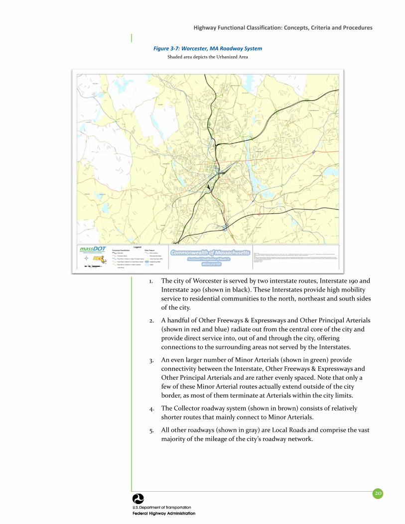
3.3 A Real World Example At this point, the concepts, criteria and definitions of all Federal functional classification categories have been presented. However, to strengthen the functional classification practitioner’s understanding of these topics, the real world example of the city of Worcester, MA is presented below (Figure 3-7).
Highway Functional Classification: Concepts, Criteria and Procedures
20
1. The city of Worcester is served by two interstate routes, Interstate 190 and Interstate 290 (shown in black). These Interstates provide high mobility service to residential communities to the north, northeast and south sides of the city.
2. A handful of Other Freeways & Expressways and Other Principal Arterials (shown in red and blue) radiate out from the central core of the city and provide direct service into, out of and through the city, offering connections to the surrounding areas not served by the Interstates.
3. An even larger number of Minor Arterials (shown in green) provide connectivity between the Interstate, Other Freeways & Expressways and Other Principal Arterials and are rather evenly spaced. Note that only a few of these Minor Arterial routes actually extend outside of the city border, as most of them terminate at Arterials within the city limits.
4. The Collector roadway system (shown in brown) consists of relatively shorter routes that mainly connect to Minor Arterials.
5. All other roadways (shown in gray) are Local Roads and comprise the vast majority of the mileage of the city’s roadway network.
Figure 3-7: Worcester, MA Roadway System Shaded area depicts the Urbanized Area

Highway Functional Classification: Concepts, Criteria and Procedures
21
3.4 Final Considerations In many instances, assigning a functional classification to a roadway is straightforward, especially for Interstates and Locals. However, there is flexibility when deciding between adjacent classifications. For example, deciding whether a given roadway acts as a Minor Arterial or Major Collector can be subject to debate. Deciding between a Major Collector and Minor Collector assignment can be even more challenging.
To assist transportation planners responsible for determining the functional classification of roadways, this guidebook offers a helpful tool that can make the classification process of classifying “borderline” roadways a bit easier. Table 3-5 illustrates the range of lane width, shoulder width, AADTs, divided/undivided status, access control and access points per mile by functional classification categories.
Table 3-5 also presents guidelines for mileage and VMT ranges for Federal functional classifications of roads. These guidelines are based on an analysis of 2008 HPMS data and are adjusted to represent reasonable ranges. The table presents mileage and VMT extents for rural states, urban states and all states. For this purpose rural states are defined as having 75 percent or less of their population in urban areas. Research determined this was a natural breakpoint that approximated the geographic difference between the States.
As expected, Interstates account for the lowest portion of total system miles, but the greatest portion of travel. Conversely, Local Roads comprise the greatest portion of system mileage with Collectors carrying the lowest percentage of travel volume. Therefore, as a primary consideration in functional classification, planners and engineers can use mileage as a guideline. Where roadway systems significantly deviate from these ranges, State DOTs should consider adjusting their roadway assignments during the functional classification review process and at least every 10 years as part of the response to Census defined Urban Boundary changes. FHWA intends to review these guideline ranges for mileage and VMT periodically.
Lastly, as a result of variances within the functional classification system, the guidelines have overlapping ranges of values. This allows greater flexibility in determining functional classification (see Figure 3-8).
Figure 3-8: Classification Overlap
Source: FHWA
Arterial
Collector
Local
Areas of U
ncertainty

Highway Functional Classification: Concepts, Criteria and Procedures
22
Table 3-5: VMT and Mileage Guidelines by Functional Classifications - Arterials
Arterials
Interstate Other Freeways & Expressway Other Principal Arterial Minor Arterial Typical Characteristics
Lane Width 12 feet 11 - 12 feet 11 - 12 feet 10 feet - 12 feet Inside Shoulder Width 4 feet - 12 feet 0 feet - 6 feet 0 feet 0 feet
Outside Shoulder Width 10 feet - 12 feet 8 feet - 12 feet 8 feet - 12 feet 4 feet - 8 feet AADT1 (Rural) 12,000 - 34,000 4,000 - 18,5002 2,000 - 8,5002 1,500 - 6,000
AADT1 (Urban) 35,000 - 129,000 13,000 - 55,0002 7,000 – 27,0002 3,000 - 14,000 Divided/Undivided Divided Undivided/Divided Undivided/Divided Undivided
Access Fully Controlled Partially/Fully Controlled Partially/Uncontrolled Uncontrolled Mileage/VMT Extent (Percentage Ranges)1
Rural System Mileage Extent for Rural States2 1% - 3% 0% - 2% 2% - 6% 2% - 6%
Mileage Extent for Urban States 1% - 2% 0% - 2% 2% - 5% 3% - 7% Mileage Extent for All States 1% - 2% 0% - 2% 2% - 6% 3% - 7% VMT Extent for Rural States2 18% - 38% 0% - 7% 15% - 31% 9% - 20%
VMT Extent for Urban States 18% - 34% 0% - 8% 12% - 29% 12% - 19% VMT Extent for All States 20% - 38% 0% - 8% 14% - 30% 11% - 20% Urban System
Mileage Extent for Rural States2 1% - 3% 0% - 2% 4% - 9% 7% - 14% Mileage Extent for Urban States 1% - 2% 0% - 2% 4% - 5% 7% - 12%
Mileage Extent for All States 1% - 3% 0% - 2% 4% - 5% 7% - 114% VMT Extent for Rural States2 17% - 31% 0% - 12% 16% - 33% 14% - 27%
VMT Extent for Urban States 17% - 30% 3% - 18% 17% - 29% 15% - 22% VMT Extent for All States 17% - 31% 0% - 17% 16% - 31% 14% - 25%
Qualitative Description (Urban)
• Serve major activity centers, highest traffic volume corridors, and longest trip demands • Carry high proportion of total urban travel on minimum of mileage • Interconnect and provide continuity for major rural corridors to accommodate trips
entering and leaving urban area and movements through the urban area • Serve demand for intra-area travel between the central business district and outlying
residential areas
• Interconnect with and augment the principal arterials • Serve trips of moderate length at a somewhat lower level of travel
mobility than principal arterials • Distribute traffic to smaller geographic areas than those served by
principal arterials • Provide more land access than principal arterials without penetrating
identifiable neighborhoods • Provide urban connections for rural collectors
Qualitative Description (Rural)
• Serve corridor movements having trip length and travel density characteristics indicative of substantial statewide or interstate travel
• Serve all or nearly all urbanized areas and a large majority of urban clusters areas with 25,000 and over population
• Provide an integrated network of continuous routes without stub connections (dead ends)
• Link cities and larger towns (and other major destinations such as resorts capable of attracting travel over long distances) and form an integrated network providing interstate and inter-county service
• Spaced at intervals, consistent with population density, so that all developed areas within the State are within a reasonable distance of an arterial roadway
Provide service to corridors with trip lengths and travel density greater than those served by rural collectors and local roads and with relatively high travel speeds and minimum interference to through movement
1- Ranges in this table are derived from 2011 HPMS data. 2- For this table, Rural States are defined as those with a maximum of 75 percent of their population in urban centers.

Highway Functional Classification: Concepts, Criteria and Procedures
23
Table 3-6: VMT and Mileage Guidelines by Functional Classifications – Collectors and Locals Collectors Local
Major Collector2 Minor Collector2
Typical Characteristics
Lane Width 10 feet - 12 feet 10 - 11 feet 8 feet - 10 feet Inside Shoulder Width 0 feet 0 feet 0 feet
Outside Shoulder Width 1 feet - 6 feet 1 feet - 4 feet 0 feet - 2 feet AADT1 (Rural) 300 - 2,600 150 - 1,110 15 - 400
AADT1 (Urban) 1,100 - 6,3002 80 - 700 Divided/Undivided Undivided Undivided Undivided
Access Uncontrolled Uncontrolled Uncontrolled Mileage/VMT Extent (Percentage Ranges)1
Rural System Mileage Extent for Rural States3 8% - 19% 3% - 15% 62% - 74%
Mileage Extent for Urban States 10% - 17% 5% - 13% 66% - 74% Mileage Extent for All States 9% - 19% 4% - 15% 64% - 75% VMT Extent for Rural States3 10% - 23% 1% - 8% 8% - 23%
VMT Extent for Urban States 12% - 24% 3% - 10% 7% - 20% VMT Extent for All States 12% - 23% 2% - 9% 8% - 23%
Urban System Mileage Extent for Rural States3 3% - 16% 3% - 16%2 62% - 74%
Mileage Extent for Urban States 7% - 13% 7% - 13%2 67% - 76% Mileage Extent for All States 7% - 15% 7% - 15%2 63% - 75% VMT Extent for Rural States3 2% - 13% 2% - 12%2 9% - 25%
VMT Extent for Urban States 7% - 13% 7% - 13%2 6% - 24% VMT Extent for All States 5% - 13% 5% - 13%2 6% - 25%
Qualitative Description (Urban)
• Serve both land access and traffic circulation in higher density residential, and commercial/industrial areas
• Penetrate residential neighborhoods, often for significant distances
• Distribute and channel trips between local streets and arterials, usually over a distance of greater than three-quarters of a mile
• Serve both land access and traffic circulation in lower density residential, and commercial/industrial areas
• Penetrate residential neighborhoods, often only for a short distance
• Distribute and channel trips between local streets and arterials, usually over a distance of less than three-quarters of a mile
• Provide direct access to adjacent land • Provide access to higher systems • Carry no through traffic movement
Qualitative Description (Rural)
• Provide service to any county seat not on an arterial route, to the larger towns not directly served by the higher systems, and to other traffic generators of equivalent intra-county importance such as consolidated schools, shipping points, county parks, important mining and agricultural areas
• Link these places with nearby larger towns and cities or with arterial routes
• Serve the most important intra-county travel corridors
• Be spaced at intervals, consistent with population density, to collect traffic from local roads and bring all developed areas within reasonable distance of a minor collector
• Provide service to smaller communities not served by a higher class facility
• Link locally important traffic generators with their rural hinterlands
• Serve primarily to provide access to adjacent land
• Provide service to travel over short distances as compared to higher classification categories
• Constitute the mileage not classified as part of the arterial and collectors systems
1- Ranges in this table are derived from 2011 HPMS data. 2- Information for Urban Major and Minor Collectors is approximate, based on a small number of States reporting. 3- For this table, Rural States are defined as those with a maximum of 75 percent of their population in urban centers.
Highway Functional Classification: Concepts, Criteria and Procedures
24
Mileage and Daily Vehicle - Miles of Travel (DVMT) Ranges: While these guidelines should be considered general rules of thumb, FHWA encourages State DOTs to generate similar statistics for their roadway network and evaluate whether they fall within the normal ranges presented here. States should also apply the urban and rural guidelines as appropriate to their urban and rural areas.
Annual Average Daily Traffic: Roadway traffic volumes are typically expressed as annual average daily traffic (AADT) and represent one of the most objective characteristics of a roadway’s usage, providing a standard, easy to understand and simple metric for comparing the relative importance of roadways. In general, the higher the traffic volume is, the higher the functional classification will be (relative to the norms in the surrounding area). Therefore, examining the AADT with other roadways in both the immediate vicinity (and in the region as a whole) is helpful when deciding a “borderline” roadway classification. If, for example, when trying to determine whether a given roadway with an AADT of 3,500 should be classified as a Minor Arterial or Major Collector, most of the Minor Arterials (in the immediate area and the region at large) fall within the 4,000 to 10,000 range, and the Major Collectors fall within the 2,000 to 4,000 range, the roadway should be classified as a Major Collector.
The Big Picture: If there still remains some ambiguity surrounding what classification should be applied to a given roadway, it is often helpful to examine the roadways in close proximity to it and to consider the spacing. For example, if trying to determine whether a roadway should be classified as a Minor Arterial or Major Collector, it is useful to take a “step back” and determine whether any functional classification is under- or over-represented. If the area has a significant number of Minor Arterials, then the roadway could very well be best classified as a Major Collector. Alternatively, if there is not another Minor Arterial within a few mile radius of the roadway (assuming an urban context), then the roadway may best be designated as a Minor Arterial.
Even after careful review of a given roadway’s attributes, a small set of roadway segments that are difficult to classify can remain. For this reason, the set of mileage guidelines in Tables 3-5 and 3-6 can help provide high-level guidance regarding both the extent (mileage) and usage (daily vehicle miles of travel [DVMT]) of the roadway system that should fall into the different functional classification categories. While these guidelines have been developed for application at the State level, they can also be applied within regions.
State DOTs are required to collect, analyze and publish traffic data on the roadways within their borders. Specifically, through the Highway Performance Monitoring System, each roadway segment on the Federal-aid highway (e.g., urban roadways classified as Minor Collectors and above and rural roadways classified as Major Collectors and above) is required to have an AADT value that is based on an actual traffic count within the last3 years. Therefore, AADT is a readily available and objective metric that can be brought into the functional classification determination process.

25
SECTION 4. PROCEDURES
4.1 Introduction This section of the guidance outlines suggested procedures for assigning functional classifications to highways, including a discussion of the specific technical tasks that describe the detailed technical “how to” tasks, as well as the collaborative efforts with partner agencies to ensure the functional classification of the roadway network considers State, regional and local needs. Currently, each State maintains a categorized roadway network consistent with the Federal functional classification system. While functional classifications of some roadways can and do change over time, the functional classification of the vast majority of roadways remains stable. Consequently, the focus of each State’s efforts should be to identify roadways where the functionality has changed. These changes can take the form of newly constructed, re-aligned, extended, widened or otherwise reconfigured roadways. Equally important are changing land use and development patterns — growing residential areas, newly developed commercial or industrial centers and construction of isolated traffic generators can all have a profound impact on the roadway network serving these developments. State DOTs should establish, with local planning partners, a collaborative process of monitoring development and roadway usage patterns to ensure that the functional classification system is kept current.
While the nation’s roadway system is mature in comparison to the 1960’s-era highway system, the concepts and processes pertaining to the original Federal functional classification system are still relevant. The following section briefly presents an adaptation of the key recommendations of the 1989 guidance document, which is based on an earlier 1960’s era document.
Many State DOTs have generated their own functional classification guidance documents. For the most part, these State-specific documents are based upon FHWA’s 1989 document, augmented with additional details as necessary. To obtain a complete understanding of functional classification procedures in a particular State, these supporting documents should be reviewed as well.
4.2 Identifying the Functional Classification of a Roadway Network
A primary objective of the functional classification system is to connect traffic generators (population centers, schools, shopping areas, etc.) with a roadway network that channelizes trips logically and efficiently. As classification proceeds from identifying Arterials to Collectors to Locals, the perspective (and size) of traffic generators also moves from a larger to a smaller scale (or from a smaller to a larger scale, if starting from the local development).
When developing a functional classification network in a given area, the same basic procedures should be followed, whether the functional classification is applied in a rural or an urban area. However, due to the differences in population
Agencies can use travel demand models to validate or update their functional classification assignments. These models and the software they use produce estimates of the number of trips that travel between activity centers as well as the flows of travel on roadway segments. A particularly useful feature is “select link analysis” that shows the origin and destination location of travel from a roadway segment, and select zone analysis, which shows the path of trips from or to an activity center. Travel demand model “activity centers” represent collections of smaller areas such as block groups, census tracts or even counties, so their ability to track the path of travel from smaller areas is often limited.

Highway Functional Classification: Concepts, Criteria and Procedures
26
and land development intensity between rural and urban areas, the process and considerations used to classify roadways may be different. Because functional classification is part art and part science, these procedures are a blend of detailed, task-oriented steps and qualitative guidelines. These procedures do not eliminate judgment from the classification process, but when used as a guide, they help to apply judgment in a sound and orderly fashion.
1. Identify traffic generators. In rural areas, traffic generators may be population centers (cities and towns); recreational areas such as lakes, national and State parks; military facilities; consolidated schools; and shipping points. In urban areas, traffic generators may be business districts; air, rail, bus and truck terminals; regional shopping centers; colleges and universities; hospital complexes; military bases; industrial and commercial centers; stadiums; fairgrounds; and parks. Regional traffic generators adjacent, but outside of the area of interest, should also be identified.
2. Rank traffic generators. Traffic generators should be categorized based on their relative ability to generate trips and be first stratified into urban and rural groupings. Traffic generators thought to be significant enough to be served by a Major Collector or higher should be categorized into five to eight groups (it is better to have too many groups than to have too few, especially toward the lower end of the scale). Traffic generators with similar significance should be placed in the same group. These groups will be used to identify the functional classification of connecting roadways. Population, sales tax receipts, retail trade, visitation and employment are some examples of factors to consider when ranking traffic generations according to their significance.
3. Map traffic generators. Traffic generators should be mapped using graduated symbols of varying sizes and/or colors according to the group to which the generator belongs. This will produce a visual representation of the ranking. For example, the group of generators ranked highest should all be symbolized with the largest symbol.
4. Determine the appropriate functional classification to connect traffic generators. To determine the functional classification of roadways, work from the highest mobility facilities first by identifying Interstates, Other Freeways & Expressways, Other Principal Arterials, then Minor Arterials and Collectors (Major, then Minor). Then, by definition, Local Roads will be all of the roadways that were not classified as Arterials or Collectors. In other words, begin with a wide, regional perspective to identify Principal Arterials, then gradually move to smaller, more localized perspectives as Minor Arterials, Major Collectors and Minor Collectors are identified. In this process, consider the size of the traffic generators connected and the predominant travel distances and “travel shed”4 served.
4 “Travel shed” refers to the general area from which most travelers originate.

Highway Functional Classification: Concepts, Criteria and Procedures
27
4.2.1 Arterial Considerations Arterials serve a wide range of functions across the access-mobility spectrum. Some considerations and rules of thumb for designating roads as Arterials include:
Start with Interstates and Other Freeways & Expressways. Control of access is perhaps the easiest criterion to apply, since roadways with full or partial control of access will most always be in the Arterial classification category. It is therefore advantageous to identify these roadways first, providing a convenient starting point in defining the Arterial system.
Preserve the continuity of Principal Arterials (Interstates, Other Freeways & Expressways and Other Principal Arterials). Continuity of Principal Arterial routes traveling from rural areas, then into and through urban areas, should be preserved.
Arterials should avoid neighborhoods. They often serve as buffers between incompatible land uses and should avoid penetration of residential neighborhoods.
Most high volume roadways in urban areas function as Arterials. Notable exceptions to this rule in intensely developed area exist in cases where high volume roadways actually function as Collectors that serve traffic movements between Locals and Arterials or provide a high degree of direct access service to abutting land uses. For example, roadways that border on high-activity, low-land area generators may carry proportionally high volumes of traffic while functioning as Collectors.
The network of Minor Arterial roadways will usually intersect roadways in all other classifications.
In urban areas, guidance for distinguishing between Principal and Minor Arterials includes:
• Principal Arterials typically serve:
o Activity centers, from CBDs to larger town centers
o Important air, rail, bus and truck terminals
o Regional shopping centers
o Large colleges, medical complexes, military bases and other institutional facilities
o Major industrial and commerce centers
o Important recreational areas
• Principal Arterials provide more mobility; Minor Arterials provide more access. The land access function of Principal Arterials is subordinate to their primary function of providing mobility for traffic not destined to land adjacent to the roadway. Minor Arterials, on the other hand, have a slightly more important land access function (although even for this classification category, this is a secondary consideration).
• In general, the spacing between Principal Arterials should be greater than the spacing between Minor Arterials. In most cases, Minor Arterials will be located between Principal Arterials.

Highway Functional Classification: Concepts, Criteria and Procedures
28
• Minor Arterials in urban areas should provide service to all remaining major traffic generators not served by a Principal Arterial, and they provide adequate area-wide circulation.
• Location matters when assigning functional classification. Because traffic volumes in the outlying portions of an urban area are generally lower than in the more densely populated central areas, the traffic volume on a Minor Arterial in the central city may be greater than the volume on a Principal Arterial in a suburban area. Note: Under MAP-21, the National Highway System (NHS) was expanded on October 1, 2012, to include the Principal Arterials at that time. This one-time event did not create a link between the NHS and Principal Arterials. A change to the Principal Arterials does not automatically change the NHS.
4.2.2 Collector Considerations Collectors, which may have an important land access function, serve primarily to funnel traffic between Local to Arterial roadways. In order to bridge this gap, Collectors must and do provide access to residential neighborhoods.
When deciding between Major and Minor Collectors, the following guidelines should be considered:
A road that is not designated as an Arterial but that connects larger generators to the Arterial network can be classified as a Major Collector. Major Collectors generally are busier, have more signal-controlled intersections and serve more commercial development.
Identify Minor Collectors for under-served residential areas. After Major Collectors have been identified, Minor Collectors should be identified for clustered residential areas that have yet to be served by a roadway within higher classification categories.
In rural areas, Minor Collectors should have approximately equal distance between Arterial or Major Collector routes for equal population densities, such that equitable service is provided to all rural areas of the State. The population density within each area bounded by an Arterial and/or Major Collector route can be determined, and the existing spacing of routes already selected can be measured. Areas with poor service can then be identified by comparing the data with a table of desirable Collector spacing (mileage between routes) versus population density. Additional routes can be added to the system as necessary.
4.2.3 General Rules of Thumb for All Categories and the System as a Whole
While working down through the functional classification system of roadway classifications, the following additional considerations should be kept in mind:
Roadways that connect to and allow for the interchange of traffic with Principal Arterials are most likely to be Other Principal Arterials, Minor Arterials or Collectors.

Highway Functional Classification: Concepts, Criteria and Procedures
29
Avoid, if possible, within spacing guidelines, assigning the same functional classification to parallel routes. In the event that parallel routes are determined to provide identical functions, a determination should be made as to which of the routes is more important (as perhaps indicated by traffic volumes); the other parallel route(s) will be assigned the next lower functional classification.
In general, the more intense the development, the closer the spacing of roadways within the same functional classification category. In less dense suburban locations within an urban area, neighborhoods tend to be larger than in the more dense central parts of cities. These less dense areas generally do not require the same close spacing of facilities to serve traffic as the areas closer to the central business district.
For the most part, a single connection between two generators is all that is required. However, in some instances, an additional alternative route might be included where:
• Two apparently alternative routes are separated by geographic barriers and each is needed for connection to another intermediate generator or another intersecting route within the same classification category
• One roadway excludes commercial vehicles
• Total traffic volume is not adequately handled by one of the roadways
• One roadway is tolled
Ensure that each route terminates at a route of the same or higher functional classification. As each subsequent category in the functional classification hierarchy is identified and added to the system, the continuity of the system must be maintained.
In rural, sparsely developed areas, the spacing of various functional classification categories is often not a helpful criterion in determining functional classification.
In most cases, the most direct, most improved and most heavily traveled route should be chosen for connecting medium and small size traffic generators.
4.3 Good Practices The following section discusses and recommends a series of good practices that State DOTs may follow to keep the functional classification of its roadways as accurate as possible.
4.3.1 Ongoing Maintenance of the Functional Classification System
State DOTs are charged with ensuring that the functional classification of their roadways is kept up-to-date. In addition, FHWA recommends that States update their functional classification system continually as the roadway system and land use developments change. States should also consider reviewing their systems every 10 years to coincide with the decennial census and the adjusted urban area boundary update cycle.
FHWA encourages States to develop their own more detailed and more quantifiable guidelines. The state of Wisconsin has developed robust algorithms taking into account factors of the population of the areas connected by a roadway, land use, spacing and current AADT volumes.

Highway Functional Classification: Concepts, Criteria and Procedures
30
This maintenance process involves ongoing coordination with local planning partners to identify roadways that require changes to their functional classification, due to changes in transportation network and/or land use patterns.
These changes can involve:
Adding newly constructed or extended roadways to the network, which can in turn affect the functional classification of connecting or nearby roadways
Upgrading the functional classification of an existing roadway due to land use changes or an improvement made to the roadway
Downgrading the functional classification of an existing roadway due to land use changes, traffic controls that discourage through traffic or other controls that limit the speed and capacity of a road
Actively maintaining the functional classification attributes of roadways will reduce the level of effort needed for the periodic updates. As State DOTs work with their local transportation planning partners on various initiatives such as long-range planning activities and project programming and development, issues related to the functional classification should be kept in mind. Useful questions to ask are the following:
Have new significant roadways been constructed that may warrant Arterial or Collector status?
Has any previously non-divided Principal Arterial roadway been reconstructed as a divided facility?
Has any new major development (such as an airport, regional shopping center major medical facility) been built in a location that has caused traffic patterns to change?
Has there been significant overall growth that may have caused some roadways to serve more access or mobility needs than they have previously?
Have any Arterial or Collector roadways been extended or realigned in such a way to attract more through trip movements?
Has a particular roadway experienced a significant growth in daily traffic volumes?
A key success factor for State DOTs is to have a well-documented process for changing the functional classification of an existing roadway. This process, along with a description of what the functional classification is and why it is important, should be readily accessible on the internet.
Many State DOTs have developed a functional classification change request form (see Figure 4-1). These forms ensure that consistent information and evidence supporting such a change are provided. Typically, information — such as the roadway location, the justification for the change and letters or signatures expressing local support — is required.
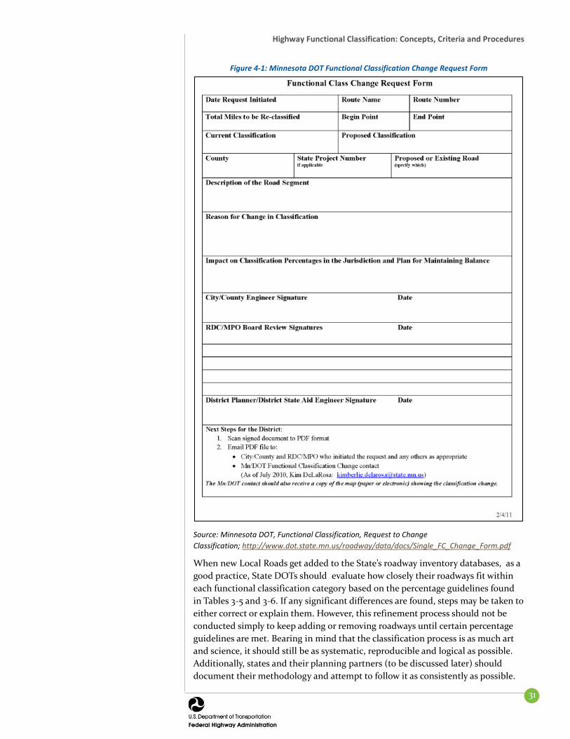
Highway Functional Classification: Concepts, Criteria and Procedures
31
Figure 4-1: Minnesota DOT Functional Classification Change Request Form
Source: Minnesota DOT, Functional Classification, Request to Change Classification; http://www.dot.state.mn.us/roadway/data/docs/Single_FC_Change_Form.pdf
When new Local Roads get added to the State’s roadway inventory databases, as a good practice, State DOTs should evaluate how closely their roadways fit within each functional classification category based on the percentage guidelines found in Tables 3-5 and 3-6. If any significant differences are found, steps may be taken to either correct or explain them. However, this refinement process should not be conducted simply to keep adding or removing roadways until certain percentage guidelines are met. Bearing in mind that the classification process is as much art and science, it should still be as systematic, reproducible and logical as possible. Additionally, states and their planning partners (to be discussed later) should document their methodology and attempt to follow it as consistently as possible.
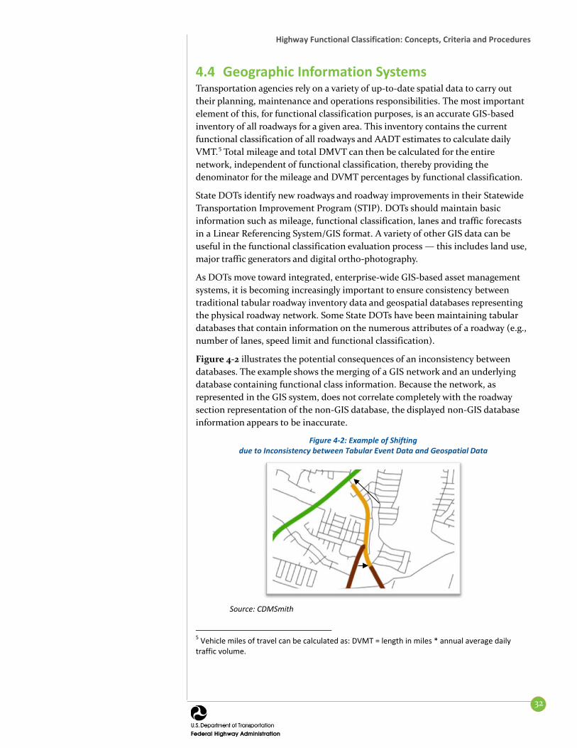
Highway Functional Classification: Concepts, Criteria and Procedures
32
4.4 Geographic Information Systems Transportation agencies rely on a variety of up-to-date spatial data to carry out their planning, maintenance and operations responsibilities. The most important element of this, for functional classification purposes, is an accurate GIS-based inventory of all roadways for a given area. This inventory contains the current functional classification of all roadways and AADT estimates to calculate daily VMT.5 Total mileage and total DMVT can then be calculated for the entire network, independent of functional classification, thereby providing the denominator for the mileage and DVMT percentages by functional classification.
State DOTs identify new roadways and roadway improvements in their Statewide Transportation Improvement Program (STIP). DOTs should maintain basic information such as mileage, functional classification, lanes and traffic forecasts in a Linear Referencing System/GIS format. A variety of other GIS data can be useful in the functional classification evaluation process — this includes land use, major traffic generators and digital ortho-photography.
As DOTs move toward integrated, enterprise-wide GIS-based asset management systems, it is becoming increasingly important to ensure consistency between traditional tabular roadway inventory data and geospatial databases representing the physical roadway network. Some State DOTs have been maintaining tabular databases that contain information on the numerous attributes of a roadway (e.g., number of lanes, speed limit and functional classification).
Figure 4-2 illustrates the potential consequences of an inconsistency between databases. The example shows the merging of a GIS network and an underlying database containing functional class information. Because the network, as represented in the GIS system, does not correlate completely with the roadway section representation of the non-GIS database, the displayed non-GIS database information appears to be inaccurate.
Figure 4-2: Example of Shifting due to Inconsistency between Tabular Event Data and Geospatial Data
Source: CDMSmith
5 Vehicle miles of travel can be calculated as: DVMT = length in miles * annual average daily traffic volume.

Highway Functional Classification: Concepts, Criteria and Procedures
33
As shown above, GIS systems enable roadway segment color coding for validation and public display. An example of a color coding scheme for roadways by functional classification is shown in Figure 4-3. If followed, this suggestion would improve future mapping consistency.
4.4.1 Proactive Communication and Accessibility of Information
State DOTs should create a 2-way communication network with internal and external users of functional classification information. The unit within the State DOT responsible for maintaining the official functional classification network should keep a list of internal and external users of functional classification information and provide them with guidance and a mechanism for updating functional classifications. Increasingly, enterprise-wide databases and information provided over the internet (either with static PDF maps or more sophisticated interactive, dynamic online mapping applications) allow end-users quick and convenient access to roadway attribute information, including functional classification. Additionally, internal linkages and strong lines of communication with the DOT offices responsible for asset management, system inventories and operations can ensure that updates and changes to their roadway databases are transferred to a master GIS inventory which the functional classification process has access.
4.5 Partners in the Functional Classification Process Whether processing a single functional classification change request or conducting a comprehensive statewide functional classification review in response to the establishment of the updated Adjusted Census Urban Boundaries, a variety of planning partners should be involved to ensure informed consent of the functional classification designation for a State’s roadways.
4.5.1 Metropolitan Planning Organizations MPOs are the primary local contact for the DOTs in Urbanized Areas. MPOs may initiate requests for revising the functional classification of a roadway within their planning area, either on their own initiative or on behalf of member jurisdictions. For requests originating from a member jurisdiction, the MPO may conduct an initial review to ensure compliance with functional classification criteria. Typically, MPOs will forward requests along with their recommendation for approval or disapproval to the State DOT unit responsible for maintaining the functional classification information. In some cases, local governments work directly with the State DOT, with concurrence from the MPO.
Today’s geospatial technologies allow this data to be easily “viewed” in the context of a spatially accurate map display. Therefore, it is important that the linearly referenced tabular data, when integrated into a state DOT’s traditionally separated databases, be dynamically segmented on a routed roadway network and be spatially correct.
This issue may become apparent when roadways are mapped and symbolized according to their functional classification. The mapped functional classification designations often stop short or slightly overshoot their proper terminal location.
Figure 4-3 Sample Roadway Color Scheme
Interstate 1 Other Freeways and Expressways 2 Other Principal Arterial 3 Minor Arterial 4 Major Collector 5 Minor Collector 6 Local 7

Highway Functional Classification: Concepts, Criteria and Procedures
34
4.5.2 State DOTs For the sake of efficiency, a single specific unit with the DOT should be responsible for maintaining the official functional classification designation of all roads within the State. This unit should also be in charge of coordinating with FHWA on matters related to functional classification and be the final State decision-maker for all functional classification issues. The unit should also ensure that all submissions for changes to the functional classification of a roadway have followed the appropriate documented procedures. If the State DOT approves a change, the unit should submit the change, along with supporting information, to the FHWA Division Office for their review and approval. Upon receipt of FHWA approval (or disapproval), the DOT should notify the affected local jurisdiction of the decision.
DOT regional or district offices may be responsible for submitting system revisions for all State highways outside an MPO’s planning area and coordinating proposed system revisions for areas within the planning jurisdiction of an MPO.
Once a change has been approved by the FHWA Division Office, the State DOT may revise the official repository of functional classification information and update ancillary systems and work products to reflect the change.
4.5.3 Counties and Other Agencies Counties may be responsible for initiating functional classification changes on roadways under their jurisdiction but outside of an MPO planning area. Counties within an MPO’s planning area should coordinate proposed system revisions with the MPO and submit any proposed changes to the State DOT.
In addition to MPOs, counties and State DOTs, other local government and regional entities — such as cities, rural transportation planning organizations, regional development commissions, councils of government, etc. — may also submit changes and participate in the update process.
4.6 Suggested Procedural Tasks This section of the guidance outlines a series of recommended technical and procedural steps to review the functional classification of a State’s roadway network. These tasks should be conducted through a collaborative effort between each State DOT and its local planning partners. In an ideal setting, the State and its partners should assess whether its roadways are properly classified on a continuous basis. Because new roads and major land development projects take years of advance planning, State DOTs should anticipate and respond to functional class adjustments in tandem with development activity. Additionally, the entire network of roadways should be reviewed after the development of the adjusted urban area boundaries. For those State DOTs that actively maintain and update the functional classifications of their roadway system, this formal process should be rather straightforward.
The following suggested procedures offer the most robust and detailed steps in the update process (Figure 4-4). Even for the most challenging of circumstances, the process of official review and submittal of the updated functional classification system can take less than 36 months to complete from the time of FHWA approval of the adjusted urban area boundaries.
State DOTs should complete the adjusted urban area boundary process within 2 years of the boundary release date.
The functional classification update should be completed within 3 years following the approval of the adjusted urban area boundaries.

Highway Functional Classification: Concepts, Criteria and Procedures
35
Figure 4-4: Good-Practice Timeframe for Functional Classification Updates in Months
Source: CDM Smith
States and their partners should re-evaluate the functional classification of the road system at least every 10 years, coinciding with the decennial census. FHWA highly recommends that this process be completed within 3 years of the formal approval of the adjusted urban area boundaries so that all States are coordinated with the same census. FHWA considers the State DOT to be the authority during this process and relies upon it to take an active leadership role.
FHWA Division Offices may correspond with State DOTs to formally launch the functional classification system review. This notice, which can accompany the approval of the adjusted urban area boundaries, reminds the State DOTs of their responsibilities and provide information regarding how and when the functional classification information should be submitted.
The following listing presents a good practice level functional classification review process with a 24 month completion timeframe, following approval of the adjusted urban area boundaries.
1. Mobilize the Functional Classification Update Process
a. Form a team to specifically guide the functional classification review and update process. Establish a functional classification review team composed of State and regional planners that have a vested interest in the final delineation of the functional classification designations. Individuals with experience in Federal transportation funding, highway design, traffic operations and the metropolitan transportation planning process should have a seat on the committee. This review team should be responsible for reviewing proposed changes to the functional classification network from local planning partners.

Highway Functional Classification: Concepts, Criteria and Procedures
36
b. Generate data, maps, etc. for use by local planning partners. Incorporate approved adjusted urban area boundaries in the enterprise GIS system and produce functional classification maps at a variety of scales that are relevant to local planning partners. These may include statewide, district, county and municipal scales.
c. Contact local planning partners. Contact various local planning partners to explain the task at hand and request their participation. MPO staff should be key partners, and other regional planning agencies, counties and/or local municipalities should be consulted as necessary. For many areas in which engaging local partners can be difficult, it is appropriate for State DOTs to be responsible for reviewing the functional classification of roadways.
2. Work with Local Planning Partners in the Functional Classification Review Process
a. Deliver data and documents to local planning partners. Transmit the maps described in #1b (and/or GIS data used to make such maps) to local planning partners. This transmittal should include specific instructions in terms of data formats, spatial accuracy, update processes and expected completion dates. The functional classification guidance document should also be shared with everyone involved in this process. A strong emphasis should be placed on transmitting the data in a timely fashion. In-person or video conference meetings can be extremely valuable to ensure proper communication and mutual understanding.
b. Work with Local Planning Partners. As necessary, a State DOT will work with the local planning partners to ensure that the functional classification review and update process meets their expectations. In urban areas, close collaboration with MPOs is extremely important. Regional workshops hosted by MPOs can be valuable in ensuring that there is a common understanding of the process and the schedule for delivery. While the exact details surrounding information exchange may vary from state to state, the local planning partners are generally expected to review the current functional classification network, in the context of the newly revised adjusted urban area boundaries, and submit a set of proposed changes to the functional classification of roadways in their area. Whether a large or minimal number of changes, sufficient explanation should be provided to justify each recommended functional classification change (see Table 3-1: Characteristics of Urban and Rural Arterials for examples). In many areas, proposed functional classification changes require formal MPO approval.
Highway Functional Classification: Concepts, Criteria and Procedures
37
3. Make Functional Classification Changes
a. Gather, review and incorporate all proposed changes. The State DOT must review a local or regional transportation agency’s proposed changes to ensure that they are reasonable. Special attention should be paid to the consistency of classifications at regional boundaries, overall route continuity, spacing and mileage and DVMT percentage guidelines. In addition, DOTs should coordinate with neighboring States to ensure consistency at State boundaries. If possible, potential system-wide changes should be made in a “test” environment to avoid affecting the official enterprise system during the analysis of proposed changes. Follow-up meetings may be necessary to resolve issues discovered by the DOT.
b. Submit draft functional classification network information to FHWA. Once the State DOT has successfully reviewed and concurred with all recommend functional classification changes, it should submit the draft final functional classification network to its FHWA Division Office for final approval. The specific geospatial format of data delivery should be worked out between the State DOT and its FHWA Division. Separately, hard copy maps at a scale sufficiently small enough to evaluate the functional classification network should be provided. Should the Division Office have any issues with the proposed functional classification network, the State DOT and the affected local planning entities should meet to decide upon a mutually agreeable solution. Note: Any changes to the National Highway System (NHS) will need to be coordinated with FHWA HQ Office of Planning, Environment and Realty. Approval of changes to the NHS happens in FHWA HQ, and the procedures for modifications are detailed in 23 CFR 470.
c. Incorporate Functional Classification Changes into Enterprise Systems Once FHWA approval has been received, any proposed functional classification changes should be made into the enterprise database systems that house the official records of roadway functional classification. These functional classification changes should be forwarded to FHWA HEPP for inclusion into the HEPGIS database and also be incorporated into the June 15th HPMS data transmittal.

Highway Functional Classification: Concepts, Criteria and Procedures
38
An example functional classification table from Massachusetts can be found in Table 4-1.
Table 4-1: Example Massaschusetts Roadway Functional Classification Table Ref#
City/Town Roadway From To Existing
Classification Proposed
Classification Distance (Miles)
Map
1 Blandford Huntington
Rd Chester Rd /
North St Huntington Town
Line Rural Major
Collector Local Road 3.80 1
Huntington Blandford
Hill Rd Route 20
Blandford Town Line
Rural Major Collector
Local Road 0.83
2 Blandford Cobble
Mountain Rd
Russell Town Line
Birch Hill Rd Rural Major
Collector Local Road 2.80
Blandford Birch Hill Rd Route 23 Cobble Mountain
Rd Rural Major
Collector Local Road 0.24
Granville Wildcat Rd Cobble
Mountain Rd
Old Westfield Rd Rural Major
Collector Local Road 1.94
Granville Phelon Rd North Lane
#2 Cobble Mountain
Rd Rural Minor
Collector Local Road 1.78
Granville Cobble
Mountain Rd
Phelon Rd Russell Town Line Rural Minor
Collector Local Road 1.30
Russell Cobble
Mountain Rd
Blandford Town Line
Granville Town Line
Rural Major Collector
Local Road 0.33
3 Chester Bromley Rd Huntington
Town Line 4 Skyline Trail Local Road
Rural Minor Collector
7 3.14
Huntington Bromley Rd Chester
Town Line Route 112 Local Road
Rural Minor Collector
1.79
4 Huntington Country Rd Route 112 Route 66 Local Road Rural Major
Collector 3.04
5 Holyoke Bobala Rd Whitney
Ave West Springfield
Town Line Local Road
Urban Minor Collector
0.83 2
West
Springfield Interstate
Dr Holyoke
Town Line Prospect Ave Local Road
Urban Minor Collector
0.53
6 West
Springfield Prospect
Ave Westfield Town Line
Bernie Ave Urban Minor
Collector Local Road 2.18
West
Springfield Morgan Rd
Prospect Ave
Amostown Rd Urban Minor
Collector Local Road 1.24
West
Springfield Amostown
Rd Morgan Rd Pease Ave
Urban Minor Collector
Local Road 0.65
Westfield Old Holyoke
Rd
East Mountain
Rd
West Springfield Town Line
Urban Minor Collector
Local Road 0.60
Description of Changes 1. Huntington Road in the Town of Blandford and Blandford Hill Road in the Town of Huntington no longer provide access
to through traffic. Additionally, portions of this roadway are unsurfaced. For this reason, it is recommended that this roadway be downgraded from a Rural Major Collector to a Local Road.
2. The Department of Homeland Security recently closed access to Cobble Mountain Road in the Town of Blandford in order to increase security of the Cobble Mountain Reservoir. Consequently, it is recommended that all roadways
discussed in Reference #2 in Table 1 be downgraded to Local Roads due to the inaccessibility and lack of continuity of the roadway functional classification system.
Sample functional classification changes listed, with examples of supporting justification

Highway Functional Classification: Concepts, Criteria and Procedures
39
Table 4-2 presents good practice milestones for the overall development and submittal process.
Table 4-2: Key Milestones for Development and Submittal of the Functional Classification Network
Event Month Following FHWA Adjusted Urban
Area Boundary Approval State DOT launches the formal functional classification update process after FHWA approves the State’s adjusted urban area boundaries
Month 1
State DOT works with planning partners to review and propose changes to the functional classification of its roadways
Months 2-17
State DOT gathers and processes all proposed function classification changes and submits draft final data and/or maps to FHWA Division Office for review
Months 18-20
DOT incorporates updates into planning process and related databases to ensure submittal of updated functional classification in upcoming June 15th HPMS submittal
Months 22-24

40
SECTION 5. APPLICATIONS
5.1 Performance This section of the guidance document details a variety of ways functional classification data may be used by Federal, State, local and other entities. Transportation agencies organize many of their administrative, budgetary, operations and maintenance activities around functional classification. Functional classification is also an important organizing element in data management and highway statistics reporting.
Currently, Federal and State funding programs assign a substantial share of capital and operating resources to the Principal Arterial system, in comparison to lower functional classifications. Likewise, expectations for condition and performance tend to be higher for the higher functional classifications. There is risk associated with not investing in and maintaining the system that carries the most people and goods.
5.2 Data Needs and Reporting Statistics derived from the Federal roadway databases are organized around functional classification. This data are used in a number of ways, including reporting on the condition of the nation’s roadways to Congress and in other highway statistics reports and studies.
5.2.1 Impact of Functional Classification Changes The changes brought about in the functional classification categories with this updated guidance document will lead to more uniform and more accurate classification of roadways across the country. This will improve the tracking, monitoring and reporting on the performance of the system and specific system elements at a national and State level.
5.3 Secondary Functional Classification Uses Functional classification is used by transportation agencies in a number of ways, from design to maintenance. The hierarchal system correlates the purpose of a roadway with all the external factors transportation agencies handle. The functional classification of a roadway is often a factor in decision-making by transportation agencies.
Program and Project Prioritization – In a climate of constrained resources, functional classification often plays a role in the prioritization of expenditures. Several transportation agencies have developed separate funding programs to support the roadway systems that serve their longest distance travel, a large proportion of which comprises the Principal Arterial system.
Asset Management – Functional classification plays a role in transportation agencies’ asset management programs, as agencies generally work to preserve

Highway Functional Classification: Concepts, Criteria and Procedures
41
and protect their most important assets — those that serve the most people and goods.
Safety Programs – Functional classification is used by transportation agencies to evaluate the safety of their roadways and implement safety improvement programs. Agencies consider the type of roadway in evaluating the significance of crash rates. The typical safety improvement may also vary widely depending on the functional classification of a roadway. For example, speed reduction or signage improvements may be more effective in reducing crashes on a Local Road than on an Arterial.
Highway Design – There is a correlation between functional classification and design. As an illustration, lower class roadways have lower speed limits, narrower lanes, steeper curves, etc., while higher class roadways have higher speed limits, wider lanes and fewer sharp curves. The relationship between functional classification and highway design is discussed in the following section (Subsection 5.4.1).
Bridge programs – Functional classification often plays a key role in a States’ bridge program. For example, some States have set thresholds, such as a functional classification of Local with low traffic volume, at which 1-lane bridges are acceptable.
Traffic control – Some transportation agencies may look to functional class to determine the most appropriate intersection control measure to use.
Maintenance – Functional classification often plays a role in resurfacing cycles, which is related to asset management and project prioritization. The classification of a roadway also impacts general maintenance and snow/ice removal in inclement weather.
5.4 Highway Design 5.4.1 The Relationship between Functional Classification and
Design Functional classification does not dictate design; however, the two influence one another. There is a great deal of latitude in the design of a roadway relative to its functional classification.
Transportation agencies may maintain their own roadway typology. But it is also important that the Federal functional classification system (e.g., FHWA reporting guidelines) be followed. Secondary roadway typologies developed by transportation agencies can be descriptive of how an agency wants vehicles to interact in different settings. Some States, for example, allow for local control over design standards in roadway-dense areas. This is essentially a form of context sensitive solutions (CSS).6
6 Context sensitive design describes a process and practice that considers the both the immediate environment of the roadway and the transportation needs of the communities it serves. For more information, see http://contextsensitivesolutions.org.

Highway Functional Classification: Concepts, Criteria and Procedures
42
The following presents a summary of key resources available on how functional classification can work in concert with livable and walkable communities.
5.4.1.1 AASHTO Green Book and Flexibility in Highway Design Although States’ design standards are often based on the AASHTO Green Book, FHWA’s Flexibility in Highway Design document illustrates flexibility options for States to tailor their designs to incorporate community values while safely and efficiently moving people and goods.
The AASHTO Green Book and other design manuals recognize the relationship between highway functional classification and design criteria. The AASHTO Green Book states that, “The first step in the design process is to define the function that the facility is to serve. The level of service required to fulfill this function for the anticipated volume and composition of traffic provides a rational and cost effective basis for the selection of design speed and geometric criteria within the range of values available to the designer (for the specified functional classification). The use of functional classification as a design type should appropriately integrate the highway planning and design process.”
The Green Book explains that functional classification decisions are made well before an individual project is selected to move into the design phase. This decision is made on a system-wide basis by cities, counties or State DOTS or MPOs as part of their transportation planning process. Because these decisions require considerable lead time, the functional classification of a roadway often represents a decision made years before the road is built. After a functional classification has been assigned to a roadway, however, there is still a degree of flexibility in the major controlling factor of design speed. There are no “cookie-cutter” designs for roadways. Instead, there is a range of geometric design options available.
5.4.1.2 Livability By FHWA definition, “Livability is about tying the quality and location of transportation facilities to broader opportunities such as access to good jobs, affordable housing, quality schools, and safe streets.” The term captures and recognizes the pervasive influence of transportation in our daily lives and provides a justification for transportation investments that address broader social goals such as quality of life. Specific investments include expanding the use of Intelligent Transportation System (ITS) technologies, quiet pavements and Travel Demand Management approaches in system planning and operations.
FHWA’s Livability in Transportation Guidebook cautions that functional classification based designs may not be responsive to context. The report notes the traditional association of functional classification with the movement of vehicles, but it also notes the historical lack of recognition regarding the influence of land use density and mix on the feasibility and desirability of walking, as well as the influence of land use density and mix on setting operating speeds that are appropriate for the level of pedestrian activity present. The report describes corridor re-design initiatives that have preserved mobility for vehicles and enhanced access for travel by foot. These initiatives have produced, when considering all modes, including bicyclists, pedestrians, transit users, a more optimal outcome on the mobility-access continuum.

Highway Functional Classification: Concepts, Criteria and Procedures
43
5.4.1.3 Smart Transportation Guidebook The Smart Transportation Guidebook: Planning and Designing Highways and Streets that Support Sustainable and Livable Communities, New Jersey and Pennsylvania Departments of Transportation, March 2008, recommends an approach to roadway planning and design that tailors transportation investments to the specific needs of each project. The ultimate goal of the guidebook is to integrate the planning and design of streets and highways in a manner that fosters development of sustainable and livable communities. The guidebook proposes a new roadway typology to design roadways that better reflect their role in the community and the larger transportation network. The typology (Table 5.1 in the Smart Transportation Guidebook) is shown below as Figure 5-1. This scheme focuses more narrowly on the characteristics of access, mobility and speed. And, the guidebook emphasizes that this typology should be used only as a planning and design “overlay” for individual projects and should not replace the traditional functional classification system.
Figure 5-1: “Table 5.1 Roadway Categories” from the Smart Transportation Guidebook, March 2008
Source: Pennsylvania Department of Transportation
The guide addresses design options for roadway attributes such as:
Travel lane width A shift to designing for desirable operating speed versus design speed Shoulder width On-street parking Bicycle facilities Medians Intersections (including turn radii) Pedestrian facilities Landscaping Access and spacing
The guidebook describes seven prototypical development types and the design attributes appropriate for each, by roadway classification. The design options for a Community Arterial (row 2 from Figure 5-1 above) are shown in Figure 5-2.

Highway Functional Classification: Concepts, Criteria and Procedures
44
Many States and localities have adopted policies that aim to consider the needs of all roadway users. Such policies have been referred to as ‘Complete Streets’ policies. The PennDOT Smart Transportation Guide has been identified as a good example of addressing Complete Streets issues in the American Planning Association Report #559, “Complete Streets: Best Policy and Implementation Practices.”
Figure 5-2: Community Arterial Roadway Design Guidelines in Smart Transportation Guidebook
Source: Pennsylvania Department of Transportation
5.4.1.4 CSS in Designing Major Urban Thoroughfares for Walkable Communities
ITE’s Context Sensitive Solutions in Designing Major Urban Thoroughfares for Walkable Communities, 2006 is another valuable resource for practitioners. This report advances the successful use of context sensitive solutions in the planning and design of major urban thoroughfares for walkable communities. The document, which can be found at http://www.ite.org/bookstore/RP036.pdf, provides guidance on how to apply CSS concepts and principles to create roadway improvement projects consistent with their physical settings.
Specifically, this work describes the principles, benefits and importance of CSS in transportation projects; identifies how CSS principles can be applied in the planning and development of improvements to major urban thoroughfares; describes the relationship, compatibility and tradeoffs that may be appropriate when balancing the needs of users, adjoining land uses, environment and community interests; presents guidance on how to identify and select appropriate thoroughfare types and corresponding design parameters to best meet the needs of a particular context; and provides criteria for specific roadway elements along
This guidance document can be found at: http://contextsensitivesolutions.org/content/reading/dots_release_smart_transportation_guidebook/resources/smart_transportation_guidebook/

Highway Functional Classification: Concepts, Criteria and Procedures
45
with guidance on balancing stakeholder, community and environmental needs and constraints.
5.5 Assessment of Functional Classification Systems While the Federal functional classification categories play an important role in Federal, State, regional and local transportation planning, there is an emerging trend in transportation to develop new classification categories with which to group and describe roadways. At the heart of this trend is the recognition that roadways do more than move traffic. Roadways are the basic skeleton of a community and are travelways for other modes of transportation, including walking, bicycling and public transportation. The following section describes other functional classification systems in use and touches upon emerging concepts in the realm of roadway functional classification.
5.6 Emerging/Other Functional Classification Systems
While most States only use the FHWA functional classification scheme, several States have developed additional or alternative classification systems to suit their planning and engineering needs. Reasons for developing alternative functional systems include the need to incorporate unique roadway types or roadways that are not part of the Federal-aid system and the need to develop a system to meet the unique administrative or jurisdictional requirements of a State.
Oregon DOT is one State that has employed a separate classification system. This alternate system has only four categories (Interstate, Statewide, Regional and District). While there is not a single translation to convert the Federal functional classification categories to the four State categories, Table 5-1 represents a general “rule of thumb” that Oregon DOT uses for the translation between the two systems.7
Table 5-1: Oregon DOT’s Classification System
State Classification System (SCS) Description Corresponding Functional Classifications
Interstate Highways Provide connections to major cities, regions or other states; regional trips within metro areas. • Urban or Rural Interstate
Statewide Highways Provide connection to larger urban areas, ports and recreational areas that are not directly served by interstate highways
• Principal Arterial – Other • Urban Principal Arterial – Other
Freeway Expressway • Urban or Rural Other Principal Arterial
Regional Highways Provide links to regional centers, statewide or interstate highways or economic or activity centers of regional significance
• Urban or Rural Minor Arterial
District Highways Facilities of county-wide significance function largely as county and city Arterials or Collectors
• Urban or Rural Minor Arterial • Urban or Rural Major Collector • Rural Minor Collector
7 Department of Transportation, Guidelines for Updating Federal Aid Urban Boundaries and Functional Classification, July 2003 http://www.oregon.gov/ODOT/TD/TDATA/rics/docs/InstructionsForFCReview.pdf?ga=t

Highway Functional Classification: Concepts, Criteria and Procedures
46
With the institutionalization of new concepts such as sustainability, smart growth, new urbanism and complete streets comes a different perspective on transportation as a whole and on roadways in particular. These movements have shifted the dialogue from the movement of automobiles to the mobility of persons. Some States have developed roadway design guidelines that decouple the Federal functional classification system from the specific design needs of a roadway that are determined through a project development process.
The MassDOT Project Development and Design Guide8 provides designers with options that reflect the needs of a considerable range of prevailing land uses and roadway user types. While the guide notes the role that the Federal functional classification system plays in ensuring mobility, access and connectivity, as well as its role in determining funding eligibility, it also points out that MassDOT’s guidance on access control, cross-sections, sight distance, design speeds etc. reflect the appropriate level of flexibility that the department applies to roadway design. As an example, MassDOT provides ranges of acceptable design speeds based on roadway type (Arterial, Collector) and subtype, as well as area type (Rural, Suburban and Urban) and subtype.
The Idaho DOT also embraces this new concept. The DOT’s August 2009 Technical Report 5 entitled “Highway System Classification (Functional Classification)”9 states that the department has come to a new understanding that “streets should connect to their surrounding environment through adjustments in highway/street elements and functions.” This approach bucks the traditional ‘one size fits all’ approach to roadway design that has been effective in supporting vehicular mobility.
The new approach of multimodal street design encompasses four distinct elements or zones (the travelway zone, the pedestrian zone, the context zone and the intersection zone). Each element works with the others to accommodate the needs of multiple modes in harmony their abutting land uses, taking into account environmental, historical preservation and economic development objectives. Idaho’s new functional street classification system is consistent with other national good practices which recognize the importance of the different transportation functions that are accommodated within the roadway’s right of way. Increasingly, municipal thoroughfare plans are breaking the traditional “Arterial, Collector, Local” mold and using alternate typology. These typologies expand the rural/urban construct into more granular categories that recognize aesthetic and neighborhood-level concerns and explicitly account for all modes of transportation.
Idaho’s proposed functional street classification system is consistent with other national practices, which are often found at the local level. Figure 5-3 illustrates the proposed multimodal functional street classification system (which includes
8 The MassDOT Project Development and Design Guide, http://www.massdot.state.ma.us/highway/DoingBusinessWithUs/ManualsPublicationsForms/ProjectDevelopmentDesignGuide.aspx 9 Technical Report 5, Highway System Classification, August 12, 2009, http://itd.idaho.gov/transportation-performance/lrtp/reports/Tech%20Rept%205-Highway%20Systems%20Classification.pdf

Highway Functional Classification: Concepts, Criteria and Procedures
47
the categories of Freeways, Boulevards, Avenues and Streets) and relates it to the conventional street classification system. Idaho has other classes as well.
Figure 5-3: Idaho DOT’s Proposed Redefinition of Functional Street Classifications
Source: Idaho Department of Transportation Idaho Department of Transportation Statewide Transportation Systems Plan The broadening of road typologies and design options within the context of functional classification is not limited to a few DOTs. The Institute of Traffic Engineers’ Context Sensitive Solutions in Designing Major Urban Thoroughfares for Walkable Communities 10 supports and extends this way of thinking. (Figure 5-4) In addition, the ARTIST (Arterial Streets Toward Sustainability)11 concept and the United Kingdom’s Manual for Streets 12 offer new ways of categorizing roadways that support short-distance mobility and access with design options to accommodate a variety of modes and roadway treatment options.
10 Institute of Traffic Engineers, Context Sensitive Solutions in Designing Major Urban Thoroughfares for Walkable Communities, March, 2010. 11 Lund University, Department of Technology and Society, Arterial Streets Toward Sustainability, Sweden, http://www.tft.lth.se/english/research/traffic_safety/artists/?L=2 12 Department for Transport, Manual for Streets, March 29, 2007 https://www.gov.uk/government/uploads/system/uploads/attachment_data/file/3891/pdfmanforstreets.pdf
Figure 5-4: ITE Report: Context Sensitive Solutions in Designing Major
Urban Thoroughfares for Walkable Communities

Highway Functional Classification: Concepts, Criteria and Procedures
48
5.7 Future Trends Additionally, a significant change is occurring in the transportation industry related to the development of improvement projects focusing on the performance of the facility. Roadway performance can be measured in a number of ways, including mobility, speed, safety and surface condition, as well as by person throughput and the accommodation of multiple transportation modes. Increasingly, the character and context of the environment within which the roadway is located, as well as the expectation of its performance on a number of measures, are driving the design of roadway improvement projects. Gone are the days of simply verifying a roadway’s functional classification and applying a “one-size-fits-all” approach to the application of design standards of a roadway improvement project.
This movement in transportation planning to categorize roadways beyond the traditional “Arterial, Collector, Local” spectrum will continue to evolve. Continuing research and dialogue among transportation practitioners will deepen the understanding of what these alternatives can offer to a functional classification system that is relevant and meaningful at the national level.

49
SECTION 6. URBAN BOUNDARIES
6.1 Introduction Many Federal transportation programs and policies rely upon a clear and well-documented distinction between urban and rural areas. Urban and rural areas are explicitly defined by the Census Bureau according to specific population, density and related criteria. From these technical definitions, irregularities and boundaries that are separated from or inconsistent with transportation features may result. For transportation purposes, States have the option of using census-defined urban boundaries exclusively, or they may adjust the census-defined boundaries to be more consistent with transportation needs. States, in coordination with local planning partners, may adjust the urban area boundaries so fringe areas having “…residential, commercial, industrial, and/or national defense significance” (as noted in the December 9, 1991 Federal-Aid Policy Guide), are included.
Reasons for adjusting urban area boundaries for transportation planning purposes often relate to a need for consistency or geographic continuity. For example, it may be logical to include, as part of an urban area, a roadway that is used by urban residents but is located just outside the official Census Bureau urban area boundary. Or, it may make sense to designate as urban a rural pocket in the middle of an urban area (or to address alternating patterns of rural and urban-designated areas). Additionally, large, low density land uses on the urban fringe that serve the urban population such as airports, industrial parks, regional shopping centers and other urban attractions may also be included in an urban area.
On October 14, 2008, FHWA issued the memorandum “Updated Guidance for the Functional Classification of Highways” which stated, “Functional classification should not automatically change at the rural/urban boundary.” This extended the 1991 Addendum to the 1989 guidance Highway Functional Classification: Concepts, Criteria and Procedures, which provided “greater flexibility for deciding on an appropriate place for changing the functional classification when rural routes cross an urban boundary.” The 2008 memorandum proposed further study of functional classification and urban area boundary adjustment which led to this document.
This section is intended to assemble and complete all previous policy given by FHWA for establishing urban area boundaries. It has three main objectives:
1. To provide a clear definition of adjusted urban area boundaries and other related boundaries
2. To define a set of technical and administrative processes by which States, working in conjunction with local planning partners, could develop adjusted urban areas based upon urban areas as defined by the US decennial census
3. To establish data delivery protocols from the States to FHWA
The authority to establish the geographic definitions is set forth in Section 101(a) of Title 23 U.S.C. and subsequent guidance has been provided in 23 CFR 470 and in FHWA policy documents.

Highway Functional Classification: Concepts, Criteria and Procedures
50
6.2 Defining Urban and Rural The terms “urban” and “rural” mean different things to different people, and in many cases, their definitions differ depending upon the context in which they are used. At their core, the concepts of urban and rural are clear; urban areas are considered to have dense development patterns, while rural areas are considered to have sparse development patterns (see Figure 6-1). What has changed over the years, however, is the terminology used and the technical definitions of “dense” and “sparse”.
Figure 6-1: Prototypical Urban and Rural Areas
Urban Rural
Source: CDM Smith
6.2.1 Census Definitions For the 2010 Census, the Census Bureau classified as urban, all territory, population, and housing units located within urbanized areas (UAs) and urban clusters (UCs), both defined using the same criteria. The Census Bureau delineates UA and UC boundaries that represent densely developed territory, encompassing residential, commercial, and other non-residential urban land uses. An urban area comprises a densely settled core of census tracts and/or census blocks that meet minimum population density requirements, along with adjacent territory containing non-residential urban land uses as well as territory with low population density included to link outlying densely settled territory with the densely settled core. To qualify as an urban area, the territory identified according to criteria must encompass at least 2,500 people, at least 1,500 of which reside outside institutional group quarters.
For the 2010 Census the urban and rural classification was applied to the 50 states, the District of Columbia, Puerto Rico, American Samoa, Guam, the Commonwealth of the Northern Mariana Islands, and the U.S. Virgin Islands.
For classification purposes, the Census Bureau identified two types of urban areas for the 2010 Census:
Urbanized Areas (UAs)—An urbanized area consists of densely developed territory that contains 50,000 or more people. The Census Bureau delineates UAs to provide a better separation of urban and rural territory, population, and housing in the vicinity of large places.
Urban Clusters (UCs)—An urban cluster consists of densely developed territory that has at least 2,500 people but fewer than 50,000 people. The Census Bureau first introduced the UC concept for Census 2000 to provide a more consistent and
The concept of adjusted urban areas has evolved since the issuance of the Federal guidance on the topic in Chapter 4 of FHWA’s Federal-Aid Policy issued in December 1991.
According to definitions in 23 U.S.C. 101(a)(33), areas of population greater than 5,000 qualify as urban for transportation purposes in contrast to the Census Bureau’s threshold of 2,500.

Highway Functional Classification: Concepts, Criteria and Procedures
51
accurate measure of urban population, housing, and territory throughout the United States, Puerto Rico, and the Island Areas.
In general, this territory consists of areas of high population density and urban land use resulting in a representation of the “urban footprint.” Rural consists of all territory, population, and housing units located outside of UAs and UCs.
Geographic entities, such as metropolitan areas, counties, minor civil divisions (MCDs), places, and census tracts often contain both urban and rural territory, population, and housing units.
6.2.2 FHWA Definitions There are differences in the way FHWA and the Census Bureau define and describe urban and rural areas. The Census Bureau defines urban areas solely for the purpose of tabulating and presenting Census Bureau statistical data. A number of Federal agency programs use the census definitions as the starting point (if not the basis) for implementing and determining eligibility for a variety of their funding programs.
According to 23 U.S.C. 101(a)(33), areas of population greater than 5,000 can qualify as urban, in contrast to the Census Bureau’s threshold of 2,500. There are also differences in the terminology used to describe sub-categories of urban areas. FHWA refers to the smallest urban area as a Small Urban Area13, while the Census Bureau refers to Urban Clusters. This and other differences are presented in Table 6-1 and Table 6- 2.
Table 6-1: US Census Bureau Urban Area Types Defined by Population range
Census Bureau Area Definition Population Range
Urban Area 2,500+ Urban Clusters 2,500-49,999 Urbanized Area 50,000+
Table 6 2: FHWA Urban Area Types Defined by Population Range
FHWA Area Definition Population Range Allowed Urban Area
Boundary Adjustments
Urban Area 5,000+ Yes Small Urban Area (From Clusters) 5,000-49,999 Yes Urbanized Area 50,000+ Yes
Federal transportation legislation allows for the outward adjustment of Census Bureau defined urban boundaries (of population 5,000 and above) as the basis for development of adjusted urban area boundaries for transportation planning purposes, through the cooperative efforts of State and local officials. By Federal rule, these adjusted urban area boundaries must encompass the entire census-designated urban area (of population 5,000 and above) and are subject to 13 FHWA has traditionally used this term to describe Urban Areas with a population greater than or equal to 5,000 and less than 50,000, derived from Urban Clusters
A full description of the final 2010 Census urban area delineation criteria can be found in the August 24, 2011, Federal Register (76 FR 53030):
http://www.census.gov/geo/reference/frn.html.
Additional information regarding the 2010 Census urban area program can be found:
http://www.census.gov/geo/reference/ua/urban-rural-2010.html.

Highway Functional Classification: Concepts, Criteria and Procedures
52
approval by the Secretary of Transportation (23 USC 101(a) (36) - (37) and 49 USC 5302(a) (16) - (17)).
For the purposes of the boundary adjustment process, the term “adjusted urban area boundaries” refers to the FHWA boundary adjustment process in all areas of 5,000 population and above.
During the time between the release of the Census Bureau boundaries and the formal approval of the new adjusted boundaries, the previously-developed and approved adjusted urban area boundaries remain in effect. For FHWA and State DOT planning purposes, if a State DOT chooses not or is unable to adjust the urban area boundaries, the most recent unadjusted census boundaries will take effect. This could cause a roadway previously considered to be urban to now be considered rural, which may affect Federal aid funding eligibility.
To avoid this situation, States are encouraged to work with their FHWA Division Office and their local planning partners to go through the process of developing the adjusted urban area boundaries within the recommended timeframe.
6.3 Relationship to Functional Classification While the urban/rural designation is independent of the functional classification, it is important to recognize that the adjusted urban area boundary is a significant factor in developing the functional classification of a road in an urban/rural context.
Recent changes to FHWA policy have normalized14 the concepts of urban boundaries and functional classification to improve consistency. The seven functional classifications each for urban and rural areas create 14 possible combinations of functional class and area type. As an example, a roadway classified as a Minor Arterial that happens to be in an urban area has a combined classification of Urban Minor Arterial. There is no change in the definitions of the functionally classified roads; nor does this in any way change the eligibility of rural and urban-classified roads for Federal programs and policies, or how highway statistics are reported.
This change in policy provides an opportunity to clarify how functional classifications at the boundaries of urban/rural areas should be treated. The previous practice in some States of automatically changing the functional classification of a route that crosses into or out of an adjusted urban area boundary can be phased out and eliminated. Upgrading due to an actual change in function should be the operative criterion.
Special attention should be paid to locations at which roadways and boundaries are in close proximity. The adjusted urban area boundary should be designed to eliminate or minimize a roadway’s snaking in and out of the boundary. In these cases, as the boundary is adjusted, it needs to be clearly defined that the road is either in or out. This adjustment serves to maintain consistent designation of these peripheral routes and avoids the situation of a roadway alternating between urban and rural designations. Special care should be taken when developing the
14 Normalization here means simplifying the functional classification so that a roadway is classified with one meaning while urban/rural is a separate context in which the road is located.

Highway Functional Classification: Concepts, Criteria and Procedures
53
boundary so that spatial consistency is maintained with the roadways and associated attributes.
Roads that define a boundary should be considered consistently urban or rural, and it is strongly recommended that these roadways be carefully evaluated before they are included in or out of the adjusted urban area boundary. For example, in Figure 6-2, Plympton Street (a Major Collector) defines the adjusted urban area boundary and is considered to be an Urban Major Collector, while Plymouth Street (a Local Road) is considered to be an Urban Local Road.
Figure 6-2: Example of Roadway Coinciding with Adjusted Urban Area
Source: CDM Smith 2012; Data provided by Massachusetts DOT
6.4 Developing Adjusted Urban Area Boundaries This section outlines a series of recommended technical and procedural steps to develop adjusted urban area boundaries. These tasks are typically conducted through a collaborative effort between State DOTs and local planning partners. The process begins with the release of the urban area boundaries by the Census Bureau and concludes with the approval of the appropriate FHWA Division Office. Overall, the process typically takes between six months and a year to complete from the time that the census boundaries are released.
As described previously, there is no requirement to adjust the census urban boundaries. States may adopt the census boundaries as is, or they may adjust them for transportation planning purposes. The only official requirement is that an adjusted boundary includes the original urban area boundary defined by the Census Bureau in its entirety. In other words, any adjustment must expand, not contract, the Census Bureau urban area boundary.
6.4.1 Adjusted Urban Area Boundaries – Technical Tasks The first step in defining adjusted urban area boundaries is to obtain the census urban area geospatial boundary files from the Census Bureau. These files are available from FHWA’s HEPGIS website www.hepgis.fhwa.dot.gov or from the Census Bureau in a variety of GIS-compatible formats, including Arc/Info export, Arc View shape file and Arc/Info format. Historical cartographic boundary files from previous censuses are available for download at:

Highway Functional Classification: Concepts, Criteria and Procedures
54
www.census.gov/geo/www/cob/bdy_files.html.
These urban area boundary files should be edited in GIS. Additional GIS layers should also be gathered from the same year as the decennial census (e.g., 2010) or of similar vintage (see Figure 6-3). Potentially useful GIS layers include:
Land use, including areas of recent growth Roadway network Railroads Transit routes Ports (e.g., airports, seaports) Military installations Other significant traffic generators Hydrography Municipal boundaries (i.e., incorporated areas) Digital ortho-photography
Figure 6-3: 2000 Census Urban Cluster and Urbanized Areas (Ohio and Vicinity)
Source: 2000 US Census
6.4.2 Consideration Factors for Adjusting Urban Areas When adjusting the urban areas, a variety of factors should be considered. The list below describes these factors and includes an example for each. All examples are courtesy of the Arizona or Massachusetts departments of transportation.
The adjusted urban area boundary will encompass the entire urban area (of population 5,000 or greater) as designated by the Census Bureau. In Figure 6-4, no part of the original urban area was removed.

Highway Functional Classification: Concepts, Criteria and Procedures
55
Figure 6-4: Example Original Urban Area
Source: Arizona DOT; http://azdot.gov/mpd/gis/fclass/urban.asp
The adjusted urban area boundary will be one, single contiguous area. In Figure 6-5, the new boundary, like the original census boundary, is a single contiguous area without any holes or discontinuities, such that there is no rural area contained within the outer urban boundary.
Figure 6-5: Example Single Contiguous Area
Source: Arizona DOT; http://azdot.gov/mpd/gis/fclass/urban.asp
The adjusted urban area boundary often is designed to encompass areas outside of municipal boundaries that have urban characteristics with residential, commercial, industrial or national defense land uses that are consistent with or related to the development patterns with the boundary. The adjusted urban area boundary should include terminals and their access roads, if such terminals lie within a reasonable distance of the urban area (e.g. airports, seaports). In Figure 6-6, the urban area was expanded to cover the nearby Air Force base.

Highway Functional Classification: Concepts, Criteria and Procedures
56
Figure 6-6: Example Area Expanded to Cover Air Force Base
Source: Map created by CDM Smith, using data provided by Massachusetts DOT and US 2000 Census.
The adjusted urban area boundary is adjusted in many instances to encompass all large traffic generators that are within a reasonable distance from the urban area (e.g., fringe area public parks, large places of assembly, large industrial plants, etc.). In Figure 6-7, the urban area was expanded to include the industrial area east of the census urban area boundary.
Figure 6-7: Example Area Expanded to Include Industrial Area
Source: Arizona DOT; http://azdot.gov/mpd/gis/fclass/urban.asp with overlay graphic by CDM Smith to identify industrial plant.
The adjusted urban area boundary should consider transit service routes (e.g., bus route, passenger rail line) in the placement of a boundary location. However, their inclusion should not unduly distort the shape or composition of the original census-defined urban area boundary.
The adjusted urban area boundary should be defined so that its physical location is easy to discern in the field from data shown on the map. Whenever possible, if the boundary is going to deviate from political jurisdictional boundaries, it should follow physical features (e.g., rivers, streams, irrigation canals, transmission lines, railroads, streets or highways). In instances where physical features are lacking, the boundary should cross at

Highway Functional Classification: Concepts, Criteria and Procedures
57
roadway intersections which are readily identifiable in the field. In Figure 6-8, the boundary was adjusted to align with the major east-west roadway to the south.
Figure 6-8: Example Boundary Adjusted to Align with Major Roadway
Source: Source: Arizona DOT; http://azdot.gov/mpd/gis/fclass/urban.asp
After the adjusted urban area boundary has been defined using all the factors previously listed, remaining boundary irregularities should be minimized to avoid the confusion that irregular boundaries can create. In Figure 6-9, the boundary was adjusted to be considerably less complex than the original irregular census boundary.
Figure 6-9: Example Boundary Adjusted for Simplicity
Source: Arizona DOT; http://azdot.gov/mpd/gis/fclass/urban.asp

Highway Functional Classification: Concepts, Criteria and Procedures
58
Additional recommendations regarding the adjustment of the urban area boundaries include:
Adjusted urban area boundaries should be defined so that confusion or ambiguity is minimized. For example, a boundary should not be drawn in the middle of a divided highway. The divided highway should be either completely in or completely out of the urban area boundary.
In instances where a roadway defines the boundary between two urban areas, the roadway should be clearly assigned to the urban area it primarily serves. If the roadway serves each urban area equally, a business rule should be developed that assigns the roadway appropriately.
If access controlled roadways are used to define the adjusted urban area boundary, all ramps and interchanges should be either included or excluded concerning the adjusted urban area boundary and interchanges should not be divided by the boundary.
For coastal areas, if the intent of the adjusted urban area boundaries is to be reflective of the shoreline, then the generally accepted coastal boundaries most commonly used for geospatial processes, such as spatial analysis or map-making, should be used.
6.5 Adjusted Urban Area Boundaries – Procedural Tasks
If States and their local partners choose to adjust the urban area boundaries, then they must be reviewed, at a minimum, in conjunction with the census urban area boundary release.15 FHWA recommends that this process be completed within 1 year of the release of the census urban area GIS datasets. FHWA considers a State’s DOT, working with the appropriate local government entities, to be the authority during this process and relies upon State DOTs to take an active leadership role.
6.5.1 Risk Factors to Urban Area Adjustment Schedule There are several risk factors that could potentially arise and impact the amount of time it takes to complete the adjustment process. Therefore each State should develop a carefully planned approach for addressing these potential risk factors, which include:
A large number of urban areas within a State Newly created urban areas Merging of previously separate urban areas Urban areas that cross State boundaries A large number of local planning partners with which to coordinate Inconsistency in the application of adjustment criteria across the State Inconsistent interim data submittal formats Lack of active engagement by local planning partners
15 Although there is no specific FHWA policy on how often adjustments to urban area boundaries can be made, states are encouraged to make such adjustments as infrequently as possible and only when deemed absolutely necessary.

Highway Functional Classification: Concepts, Criteria and Procedures
59
Lack of DOT resources to complete the process in a timely fashion
6.5.2 Urban Area Adjustment Schedule FHWA Division Offices will correspond with State DOTs to launch the effort of developing the adjusted urban area boundaries. This transmittal is expected to be delivered soon after the Census Bureau releases its urban area boundaries, which typically occurs about 12 to 18 months following the decennial census. FHWA’s transmittal will remind the State DOTs of their responsibilities; include notification of the availability of the Census Bureau’s urban area boundary files; and provide information regarding how and when the updated boundary data should be submitted.
Figure 6-10 and the list that follows present a good practice level of procedural steps that should be completed within 12 months of the release of the Census Bureau’s urban area boundary files.
Figure 6-10: Good Practice Level of Procedural Steps for an Urban Boundary Update Process
1. Mobilize the Urban Area Boundary Adjustment Process
a. Acquire newly developed urban area boundaries from US Census. Obtain the latest decennial census urban area boundaries from the Census Bureau.
b. Form a team to guide the urban area boundary update process. Staff the team with FHWA Division personnel, along with State and regional transportation planners who have a vested interest in the final delineation of the boundaries. Individuals with experience in functional classification, Federal transportation funding, highway design, traffic operations and the metropolitan
1 2 3 4 5 6 7 8 9 10 11 12
1a. Obtain Urban Area Boundaries from U.S. Census1b. Establish AUAB Review Team1c. Generate data, maps, etc. for use by local planning partners1d. Contact local planning partners
2a. Deliver data and documents to local planning partners2b. Work with Local Planning Partners in Adjusted Urban Area Boundary Review Process
3a. Gather, review, and incorporate all proposed changes3b. Submit draft Adjusted Urban Area Boundary information to FHWA3c. Incorporate Adjusted Urban Area Boundary Changes into Enterprise Systems
Month
1. Mobilize the Adjusted Urban Area Boundary Update Process
2. Work with Local Planning Partners in Adjusted Urban Area Boundary Review Process
3. Make Adjusted Urban Area Boundary Changes
Highway Functional Classification: Concepts, Criteria and Procedures
60
transportation planning process should have a role in this process. This review team should be responsible for reviewing draft adjusted urban area boundary submittals from local planning partners.
c. Generate data, maps, etc. for use by local planning partners. Incorporate urban area boundaries from the census into data and maps that that are relevant to local planning partners. These may include statewide, district, county and municipal scales.
d. Contact local planning partners. Contact the impacted local planning partners to explain the task at hand and request their participation. For Urbanized Areas contained and/or very proximate to metropolitan planning areas, the MPO should be a key partner. For Urban Clusters, regional planning agencies, counties and/or local municipalities should be consulted. However, for many of these urban areas, additional effort may be required to properly engage these partners. In these instances, it is appropriate for State DOTs to make urban area adjustments in these areas. Finally, in some instances, regional transit service providers should also be consulted to understand their short-term routing plans.
2. Work with Local Planning Partners in the Adjusted Urban Area Boundary Update Process
a. Deliver data and documents to local planning partners. Share the original decennial census-based urban boundary maps and/or GIS data (including both Urbanized Areas and Small Urban Areas) with the local planning partners. In addition, to inform the partners and the process more completely, it helps if maps and/or GIS data representing both the previous unadjusted and adjusted urban area boundary are shared in a timely manner. This transmittal should include specific instructions in terms of data formats, spatial accuracy, update processes and expected completion dates, as well as this guidance document. In-person or video conference meetings are encouraged to enhance communication and mutual understanding. Creation of adjusted urban area boundaries should follow each State’s GIS data editing and quality control procedures (e.g., issues of scale) and performed by qualified GIS users.
b. Work with local planning partners. As necessary, each State DOT will need to work with the local planning partners to ensure that the urban area adjustment process is meeting their expectations. Close collaboration with MPOs is extremely important, and regional workshops hosted by MPOs can be very valuable in ensuring there is a common understanding of the process and schedule. While the exact details surrounding information exchange may vary from state to state, the expectation is that local planning partners will review the US census urban area boundaries in the context of the existing adjusted urban area boundaries (based upon the previous census) and determine the

Highway Functional Classification: Concepts, Criteria and Procedures
61
extent to which the boundaries should be adjusted for transportation planning purposes. The local planning partners should submit a set of proposed adjustments to the current US Census urban area boundaries in their area to their State DOT.
3. Make Adjusted Urban Area Boundary Changes
a. Gather, review and incorporate proposed changes from local planning partners. As local planning partners submit their recommendations for adjusted urban area boundaries, the State DOT must review the proposed adjustments to ensure that they are reasonable. At the very least, the DOT must ensure that no territory considered urban by the Census Bureau be left out of the adjusted urban area boundary. In addition, the State DOT should review all proposed adjusted urban area boundaries paying particular attention to locations where the adjusted urban area boundaries are co-located with another feature such as a roadway, a municipal boundary or a hydrographic feature. Some follow-up meetings may be necessary to resolve issues discovered by the DOT. The updated GIS adjusted urban area boundaries need to be incorporated into the master urban boundary layer and subjected to the DOT’s GIS quality control checks with the metadata for the layer updated.
b. Submit draft adjusted urban area boundary information to FHWA Division Office. Once the State DOT has successfully reviewed and concurred with all recommend adjusted urban area boundaries, the State DOT should submit the draft final adjusted urban area boundaries to its FHWA Division Office for final approval. The specific format of data delivery should be worked out between the State DOT and their FHWA Division Office. Various geospatial formats will be acceptable, and as developed, FHWA systems such as HPMS or HEPGIS may be used. As a final resort, hard copy maps at a scale sufficient to identify the adjusted urban area boundaries can be submitted.
c. Incorporate adjusted urban area boundary changes into Enterprise Systems. Once FHWA has approved the adjusted urban areas, the State DOT should incorporate the adjusted urban area boundary changes into the enterprise geospatial database systems that house the official record of the adjusted urban area boundaries. States are required to submit their adjusted urban area boundaries to FHWA when changes are made to the boundaries. In most cases, this submittal should only occur once after the State has completed its adjustment process.

Highway Functional Classification: Concepts, Criteria and Procedures
62
Table 6-3 presents key milestones for the overall development and submittal process (for example, using submitted data based upon the 2010 US Census data.
Table 6-2: Key Milestones for Development and Submittal of Adjusted Urban Area Boundaries
Event Months Following Decennial Census
Data Release (CDR) Census releases urban area boundaries and FHWA issues transmittal letter Month 24
Begin adjusted urban area boundary update process Month 24
DOT works with planning partners to define adjusted urban area boundaries Month 27-Month 33
Provide draft final data and/or maps to FHWA Division Office for review Month 34
DOT incorporates updates Month 35 DOT submits adjusted urban area boundaries via annual HPMS submittal Month 36
Each State should submit only boundaries for the HPMS submittal that have been approved by their FHWA Division Office.
Table 6-4 lists the attributes that are required within the FHWA geospatial database.
Table 6-3: Geospatial Database Required Attributes
Field Name Description Year_Record Year for which the data apply Urban_Code Census urban code Urban_Name Urban name
Census_Pop Census population (“recalculated” based upon the adjusted urban area boundary)
Census_Land_Area Census land area (in square miles) Shape Polygon feature
6.6 Adjusted Urban Area Boundaries – Data Transmittal Process
Each State DOT should coordinate with its local FHWA Division Office to discuss the data transmittal process. To the extent possible, all draft final boundaries should be submitted electronically in the form of GIS data and/or PDF maps. If GIS data are provided, appropriate metadata delineating the spatial accuracy, projection and definition/domain of all attributes should also be provided, as well as supporting documentation that briefly describes the process by which the boundaries were adjusted. In addition, each adjusted urban area boundary should be a single (multi-part, if necessary) polygon GIS feature. Feature names and codes should follow Federal Information Processing Standards (FIPS) conventions as well as any applicable State naming and coding standards.

63
SECTION 7. GRAPHICS SOURCES
Akos Szoboszlay
Arizona DOT
CDM Smith
Creative Commons Attribution-Share Alike 2.0 generic license; Benjamin Clark
Department for Transport, United Kingdom
FHWA
Google Earth Pro
Lund University, Department of Technology and Society
Idaho DOT
Institute of Transportation Engineers
Idaho DOT
Massachusetts DOT
Minnesota DOT
Ohio DOT
Ohio Statewide Imagery Program
Oregon DOT
Smart Transportation Guidebook
Texas DOT
US Census (2000)

Highway Functional Classification: Concepts, Criteria and Procedures
64