Embed Size (px)
Citation preview

HIGHWAY 7 CORRIDOR & VAUGHAN NORTH-SOUTH LINK PUBLIC TRANSIT IMPROVEMENTS
ENVIRONMENTAL ASSESSMENT COMPLIANCE MONITORING FOR
H3
PRELIMINARY ENGINEERING DESIGN OF H3 SEGMENT (RICHMOND HILL CENTRE TO KENNEDY ROAD)
ITEMS TO REVIEW
W:\6k\6719 Owner Engineer Retainer Services\Compliance Monitoring Sept 3 09
Legend for Ecoplans Review : Not being reviewed due to any of the following reasons: future issue; not applicable or redundant Review ECF Evidence found NSE Not sufficient evidence ENF Evidence not found Bold and Underlined
Indicated item that was reviewed
Hwy 7 Corridor & Vaughan North-South Link Public Transit Improvements Environmental Assessment Compliance Monitoring During Preliminary Engineering Design of H3 Segment
2 of 144 P:\Y2H3\4.0 Preliminary Engineering H3\4.07 H3 - Road & Rapidway Design\Hwy 7 EA Compliance Monitoring\Monitoring Document\Hwy 7 EA Compliance Monitoring - H3 + Cedarland - 2009-07-06.doc 7/6/09
Section 1.0 – Background & Purpose of the Program Compliance Review (Ecoplans)
Item Mitigation Measure / Commitment to be Monitored Responsible person / agency
Status and Description of how commitment has been addressed during design
Compliance Document Reference Item match Verified Notes
CMP Section 1.0 - “…The ACR documentation will be made available to the MOE, or its’ designate upon request, in a timely manner during an on-site inspection or audit …”
York Region Status – Pending a request. CMP/ACR documentation will be provided to MOE upon request.
Yes
CMP Section 1.2 - “Vaughan N-S Link segment of the undertaking is not included in this CMP…”
York Region Status – The TTC has prepared a separate CMP for the Spadina Subway Extension Project and is responsible for compliance monitoring related to the Vaughan N-S Link segment of the undertaking.
Yes
CMP Section 1.3 - “Modified alignment required at IBM / Cederland Avenue” “… In January 2008, Regional Council endorsed a modified alignment along Cederland Drive and Warden Avenue as a local refinement to the undertaking approved in the EA. … An amendment report will be prepared and submitted for approval following the process described in section 6.0 of this CMP.”
York Region Status - Ongoing A draft Cedarland Alignment Modification Report is being finalised following receipt of MOE and TRCA comments – see Appendix 4 for monitoring. See also Item 57 below
Draft Cedarland Alignment Modification Report – Y2H3 6.03 (ID# 3018)
Yes EC 3018 -Response to comments on the draft report Cedarland Alignment Modification Report are provided in Appendix 4 of this Table. To review these changes, the final report Cedarland Alignment Modification Report (June 2009) was reviewed. This final report will be used to verify the commitment provided in the main table.
CMP Section 1.4 - “Cornell Terminal site plan is evolving post EA approval” “…Since approval of the EA, progress has been made in the development of what is now known as the Cornell Transit Terminal. … Once the Cornell Terminal site plan is complete, it will be documented in the ACR.”
York Region Status – Ongoing Master planning of the property known as Block 11 of the Cornell Secondary Plan is underway in order to identify potential Cornell Terminal locations. The Cornell Terminal site plan is not yet complete.
Block Plan Configuration Alternatives Scenarios and related documents - CT 2.5 (ID# 2904, 3416, 3004, 3005, 3006 etc.)
Yes

Hwy 7 Corridor & Vaughan North-South Link Public Transit Improvements Environmental Assessment Compliance Monitoring During Preliminary Engineering Design of H3 Segment
3 of 144 P:\Y2H3\4.0 Preliminary Engineering H3\4.07 H3 - Road & Rapidway Design\Hwy 7 EA Compliance Monitoring\Monitoring Document\Hwy 7 EA Compliance Monitoring - H3 + Cedarland - 2009-07-06.doc 7/6/09
Section 2.0 - Monitoring of Conditions of Approval Compliance Review (Ecoplans)
Item
MOE Condition of EAA approval Responsible person / agency
Stage condition will be addressed
Status and description of how the condition has been addressed
Compliance Document Reference Item match Verified Notes
General Conditions 1.1 The Proponent shall comply with all the provisions of the EA submitted to the MOE which are hereby incorporated by reference except as provided in these conditions and as provided in any other approvals or permits that may be issued.
York Region - (more specific information to be added by ECM with annual compliance reporting for all cells in this column).
Design, Construction and Operation as specified
Status - ongoing. This condition will be addressed once all commitments have been met.)
Yes
1.2 These proposed conditions do not prevent more restrictive conditions being imposed under other statutes.
York Region As applicable Status - ongoing. More restrictive conditions imposed under other statutes is not foreseen at this time.
Yes
Public Record 2.1 Where a document is required for the Public Record, it shall be provided to the Director for filing with the Public Record maintained for this undertaking. Additional copies of such documents will be provided by the Proponent for public access at: (a) The Regional Director's Office; (b) The Clerks offices of the Regional Municipality of York; (c) The Town of Richmond Hill; (d) The Town of Markham; and (e) The City of Vaughan; (f) Richmond Hill Central Library; (g) Unionville Library; and (h) Ansely Grove Library. These documents may also be provided through other means as considered appropriate by the Proponent and acceptable to the Director.
York Region
Design, Construction and Operation as specified
Status - ongoing. To be completed with the filing of the last ACR. The MOE has received and approved the Compliance Monitoring Program dated August, 2008. The CMP is posted on York Regions york.ca website.
MOE Compliance Monitoring Program letter of approval – Y2H3 4.7 (ID# 3706)
Yes ECF ECF
3706- Hard Copy of Letter (29-Dec-08) The CMP (Aug 08) was found on York Regions york.ca website.
Compliance Monitoring and Reporting 3.1 The Proponent shall prepare and submit to the Director for review, comment and for placement on the Public Record an Environmental Assessment CMP as committed to in section 11.4 of the EA. The CMP shall be submitted no later than one year from the date of approval of the undertaking, or 60 days before the
York Region
Design stage (Timing as specified in condition 3.1)
Status – ongoing. CMP submission requirements addressed with the approval of the CMP. Carrying out of the CMP will be ongoing until the final ACR The date of the approval of the EA for the
MOE Compliance Monitoring Program letter of approval – Y2H3 4.7 (ID# 3706) EA Compliance Monitoring Program August 2008 – Y2H3 4.7 (ID# 3683) MOE letter of approval of Hwy 7 EA - Y2H3 4.7 (ID# 4039)
Yes ECF
3706- Hard Copy of Letter (29-Dec-08)
Hwy 7 Corridor & Vaughan North-South Link Public Transit Improvements Environmental Assessment Compliance Monitoring During Preliminary Engineering Design of H3 Segment
4 of 144 P:\Y2H3\4.0 Preliminary Engineering H3\4.07 H3 - Road & Rapidway Design\Hwy 7 EA Compliance Monitoring\Monitoring Document\Hwy 7 EA Compliance Monitoring - H3 + Cedarland - 2009-07-06.doc 7/6/09
Section 2.0 - Monitoring of Conditions of Approval Compliance Review (Ecoplans)
Item
MOE Condition of EAA approval Responsible person / agency
Stage condition will be addressed
Status and description of how the condition has been addressed
Compliance Document Reference Item match Verified Notes
commencement of construction, whichever is earlier. A statement must accompany the CMP when submitted to the Director indicating that it is intended to fulfill this condition. The CMP, as may be amended by the Director, shall be carried out by the Proponent.
undertaking was November 9, 2006. The final CMP was submitted to the Acting Director, Environmental Assessment and Approvals Branch on August 18, 2008 and approved on December 29, 2008.
Notice of Submission of CMP – Y2H3 4.7 (ID# 4121) York Region letter of submission of final CMP – Y2H3 4.7 (ID# 4157, 4158) MOE email confirmation of receipt of CMP - August 20, 2008 - Y2H3 6.03 (ID# 3150)
3.2 The Proponent shall provide a copy of the CMP to those agencies, affected stakeholders and/or members of the public who expressed an interest in the activity being addressed or being involved in the subsequent work no later than one year from the date of approval of the undertaking, or 60 days before the commencement of construction, whichever is earlier. If the Director amends the CMP, the Proponent shall ensure that the amended copy of the CMP is provided to those agencies, affected stakeholders and/or members of the public who expressed an interest in the activity being addressed or being involved in a timely manner.
York Region Design stage (Timing as specified in condition 3.1)
Status - Condition addressed with the approval of the CMP and circulation to affected/interested stakeholders.
EA Compliance Monitoring Program August 2008 – Y2H3 4.7 (ID# 3683) York Region letter of submission of final CMP – Y2H3 4.7 (ID# 4157, 4158) MOE Compliance Monitoring Program letter of approval – Y2H3 4.7 (ID# 3706)
Yes ECF ECF
4157 – dated 18-Aug-08 4158 – dated 31-Oct-08 3706- Hard Copy of Letter (29-Dec-08)
3.3 The Proponent shall prepare a CMP in order to provide a framework for the monitoring of the Proponent's fulfillment of the conditions of approval as set out in this Notice of Approval, and the fulfillment of the provisions of the EA for mitigation measures, built-in attributes to reduce environmental effects, public and Aboriginal community consultation, additional studies and work to be carried out, and for all other commitments made during the preparation of the EA and the subsequent review of the EA.
York Region Design, Construction and Operation as specified
Status - ongoing. Condition addressed with submission of the CMP for approval and as carried out by the Proponent until the final ACR.
EA Compliance Monitoring Program August 2008 – Y2H3 4.7 (ID# 3683) York Region letter of submission of final CMP – Y2H3 4.7 (ID# 4157, 4158) MOE Compliance Monitoring Program letter of approval – Y2H3 4.7 (ID# 3706)
Yes ECF
3706- Hard Copy of Letter (29-Dec-08)
3.4 The CMP shall at a minimum: a) set out the purpose, method and frequency of activities to fulfill compliance; b) provide a framework for recording and documenting results through the ACR; c) describe the actions required to address the commitments; d) provide an implementation schedule for
York Region Design stage Status - Condition addressed with the approval of the CMP.
Yes
Hwy 7 Corridor & Vaughan North-South Link Public Transit Improvements Environmental Assessment Compliance Monitoring During Preliminary Engineering Design of H3 Segment
5 of 144 P:\Y2H3\4.0 Preliminary Engineering H3\4.07 H3 - Road & Rapidway Design\Hwy 7 EA Compliance Monitoring\Monitoring Document\Hwy 7 EA Compliance Monitoring - H3 + Cedarland - 2009-07-06.doc 7/6/09
Section 2.0 - Monitoring of Conditions of Approval Compliance Review (Ecoplans)
Item
MOE Condition of EAA approval Responsible person / agency
Stage condition will be addressed
Status and description of how the condition has been addressed
Compliance Document Reference Item match Verified Notes
when commitments shall be completed; e) provide indicators of compliance; and f) include, but not be limited to, a consideration of the commitments outlined in Tables 10.4-1 to 10.4-4 and Tables 11.3-1 to 11.4-2 in the EA, and Proponent's letter and attachments dated May 5,2006 (included in Appendix E).
May 5, 2006 Proponent's letter and attachments included in EA Compliance Monitoring Program August 2008 – Y2H3 4.7 (ID# 3683)
3.6 The Proponent shall prepare an ACR which describes the results of the CMP and shall do so annually. 3.7 The Proponent shall submit each ACR to the Director for review and comment and for placement on the Public Record. 3.8 The timing for the submission of the ACRs shall be set out in the CMP, including the timing for submission of the first ACR. 3.9 The Proponent shall submit ACRs until all applicable conditions of approval and commitments of the EA are satisfied or until the Director notifies the Proponent that no further reports are warranted. 3.10 When alt conditions have been satisfied, the Proponent shall indicate in the ACR that this is its final submission.
York Region Design, Construction and Operation as specified
Status – ongoing. Conditions will be addressed with the submission of ACR’s until all conditions are satisfied.
Yes
Transit Technology 4.1 The Proponent shall prepare a TCP that identifies how, when and if the undertaking will convert from a Bus Rapid Transit System (BRT) to a Light Rail Rapid Transit (LRT).
York Region
Prior to conversion from BRT to LRT technology as required
Status – ongoing but not applicable at this time. Timing for technology review identified as 2012 (EA Section 5.2.2.3) A draft Transition Plan was prepared and submitted on March 02, 2007 and is presently under review as part of the ongoing Network Plan update. The draft Transition Plan included general indications of alternative schedules. Transit network analysis is ongoing including LRT / subway technology conversion considerations. A 2009 Network Update Report is planned and will
Transition Plan – Draft (March 2, 2007) – YC 2.4 (ID 910) Transmittal Memo YC 2.4 (ID 910)
Yes ECF
910 - Network connectivity is discussed in Section 4.6.1 of Highway 7 Rapidway - Section H3 – Yonge St to Kennedy Rd – Design Basis & Criteria Ver. 1.2
Hwy 7 Corridor & Vaughan North-South Link Public Transit Improvements Environmental Assessment Compliance Monitoring During Preliminary Engineering Design of H3 Segment
6 of 144 P:\Y2H3\4.0 Preliminary Engineering H3\4.07 H3 - Road & Rapidway Design\Hwy 7 EA Compliance Monitoring\Monitoring Document\Hwy 7 EA Compliance Monitoring - H3 + Cedarland - 2009-07-06.doc 7/6/09
Section 2.0 - Monitoring of Conditions of Approval Compliance Review (Ecoplans)
Item
MOE Condition of EAA approval Responsible person / agency
Stage condition will be addressed
Status and description of how the condition has been addressed
Compliance Document Reference Item match Verified Notes
address the overall sequence of implementation.
4.2 The Proponent shall submit copies of the final TCP to the Regional Director for review and comment and to the Director for placement in the Public Record file. 4.3 The Proponent shall notify the Director and Regional Director 30 days before the technology conversion is to occur.
York Region Prior to conversion from BRT to LRT technology as required
Status – ongoing but not applicable at this time. Pending as per condition 4.1
Yes
4.4 The TCP shall include an implementation schedule. 4.5 The TCP shall include information about ridership levels and compatibility of the corridor with other transit systems. 4.6 Further to Section 5.2.2.3 of the EA, which outlines that converting from BRT to LRT is dependent on other transit initiatives being developed, a copy of the TCP shall be provided to the City of Toronto, the Toronto Transit Commission, the Town of Richmond Hill, the City of Vaughan, and the Town of' Markham for review and comment. The Proponent shall provide these stakeholders a minimum 30-day comment period.
York Region Prior to conversion from BRT to LRT technology as required
Status – ongoing but not applicable at this time. Pending as per condition 4.1
Yes
5.0 Air Quality 5.1 The Proponent shall prepare a comprehensive Air Quality Assessment Report to address the air quality impacts of the Region's transportation projects. The study area for the air quality report will be determined by the Proponent in consultation with the Regional Director. 5.2 Copies of the Air Quality Assessment Report shall be submitted to the Regional Director for review and comment and to the Director for placement in the Public Record file. 5.3 The Air Quality Assessment Report
York Region Design Stage Status - Ongoing. Conditions will be addressed with the submission of the Air Quality Assessment Report.
Yes
Hwy 7 Corridor & Vaughan North-South Link Public Transit Improvements Environmental Assessment Compliance Monitoring During Preliminary Engineering Design of H3 Segment
7 of 144 P:\Y2H3\4.0 Preliminary Engineering H3\4.07 H3 - Road & Rapidway Design\Hwy 7 EA Compliance Monitoring\Monitoring Document\Hwy 7 EA Compliance Monitoring - H3 + Cedarland - 2009-07-06.doc 7/6/09
Section 2.0 - Monitoring of Conditions of Approval Compliance Review (Ecoplans)
Item
MOE Condition of EAA approval Responsible person / agency
Stage condition will be addressed
Status and description of how the condition has been addressed
Compliance Document Reference Item match Verified Notes
shall be submitted to the Regional Director prior to any construction beginning on the undertaking, including site preparation.
5.4 The Air Quality Assessment Report shall, at a minimum, include the following: a) A comparison of predicted contaminant concentrations with all available Ontario Regulation 419/05 Air Pollution - Local Air Quality Regulation Schedule 3 standards, ministry's ambient air quality criteria and proposed Canada Wide Standards for: Carbon Monoxide (CO), Nitrogen Oxides (NOx), Particulate Matter - Total Suspended Particulates (TSP) as well as PM10 and PM2.5, and selected Volatile Organic Compounds (VOCs); b) Assessment of the study area, as determined in condition 5.1, consisting of a comparison between the background contaminant concentration levels and anticipated contaminant concentration levels resulting from the project, including future traffic volumes; c) A broad-based air quality impact mitigation plan which will assist in reducing contaminant concentrations that exceed appropriate criteria/standards expected to result from construction/implementation of the project; d) Development of project contaminant emission rates using a base year and future years as required e) Use of appropriate Emission and Dispersion Models (e.g. Mobile 6, US EPA CAL3QHCR, Aermod); f) Use of five years of meteorological data (including surface and upper air data); g) Definition of roadway links as necessary;
York Region Design Stage Status - Ongoing. Conditions will be addressed with the submission of the Air Quality Assessment Report.
Yes
Hwy 7 Corridor & Vaughan North-South Link Public Transit Improvements Environmental Assessment Compliance Monitoring During Preliminary Engineering Design of H3 Segment
8 of 144 P:\Y2H3\4.0 Preliminary Engineering H3\4.07 H3 - Road & Rapidway Design\Hwy 7 EA Compliance Monitoring\Monitoring Document\Hwy 7 EA Compliance Monitoring - H3 + Cedarland - 2009-07-06.doc 7/6/09
Section 2.0 - Monitoring of Conditions of Approval Compliance Review (Ecoplans)
Item
MOE Condition of EAA approval Responsible person / agency
Stage condition will be addressed
Status and description of how the condition has been addressed
Compliance Document Reference Item match Verified Notes
h) Calculation of predicted contaminant concentrations at nearby sensitive receptors; i) Traffic volume data j) Detailed presentation of predicted data (including model input data); and, k) Presentation of conclusions and recommendations.
6.0 Complaints Protocol 6.1 Prior to construction the Proponent shall prepare a Complaints Protocol on how it will deal with and respond to inquiries and complaints received during the construction and operation of the undertaking. The Proponent shall submit the protocol to the Regional Director, District Manager, Town of Markham, Town of Richmond Hill and the City of Vaughan for review and comment. The Complaints Protocol shall be placed on the Public Record.
York Region Design Status - pending submission prior to construction. Will be addressed during detailed design.
Yes
7.0 Amending the Design of the Undertaking 7.1 If the Proponent determines that there is a minor modification and that modification does not alter the expected net effects of the undertaking, the procedure set out in section 11.5 in the EA applies to this modification. 7.2 Notwithstanding condition 7.1, section 11.5 of the EA does not apply where there is a change to the undertaking within the meaning of section 12 of the EAA. 7.3 The Proponent shall consult with EAAB to determine the appropriate steps if there is uncertainty as to application of conditions of approval 7.1 or 7.2.
York Region Design Refers to sections 1.3 and 6.0 of the CMP. Status - Ongoing. Minor changes, if any, dealt with during PE design are described under item 57 below. A draft Cedarland Alignment Modification Report is being finalised following receipt of MOE and TRCA comments – see Appendix 4 for monitoring. An EA amendment report subtitled “Response to Conditions of Approval – Vaughan N-S Link Subway Alignment Optimization” was approved by the Minister of the Environment on April 4, 2008 The TTC has prepared a separate CMP for the Spadina Subway Extension Project and is responsible for compliance monitoring related to the Vaughan N-S Link segment
Draft Cedarland Alignment Modification Report – Y2H3 6.03 (ID# 3018) MOE letter of approval of the undertaking - Vaughan N-S Link Subway Alignment Optimization – SVCC 1.0 (ID# 4160)
Yes
Hwy 7 Corridor & Vaughan North-South Link Public Transit Improvements Environmental Assessment Compliance Monitoring During Preliminary Engineering Design of H3 Segment
9 of 144 P:\Y2H3\4.0 Preliminary Engineering H3\4.07 H3 - Road & Rapidway Design\Hwy 7 EA Compliance Monitoring\Monitoring Document\Hwy 7 EA Compliance Monitoring - H3 + Cedarland - 2009-07-06.doc 7/6/09
Section 2.0 - Monitoring of Conditions of Approval Compliance Review (Ecoplans)
Item
MOE Condition of EAA approval Responsible person / agency
Stage condition will be addressed
Status and description of how the condition has been addressed
Compliance Document Reference Item match Verified Notes
of the undertaking. No other changes requiring a major amendment have been identified during PE Design. See also item 58 below.
8.0 Selection of the optimum location for the subway alignment (not applicable for the undertaking covered under this CMP)
York Region Design Stage Status - Completed. Subway Alignment Report was approved by the Minister of the Environment on April 4, 2008 (see CMP prepared by TTC / York Region for the Spadina Subway Extension)
Yes
9.1 If a Stage 2 archaeological assessment is required to be prepared and aboriginal archaeological resources are encountered during the preparation of that Assessment, the Proponent shall provide a copy of that assessment to the Huron-Wendat First Nation of Wendake, Quebec and any additional relevant First Nations as identified by the archaeologist, based on the findings of that assessment. 9.2 The Proponent shall provide the Huron-Wendat First Nation of Wendake, Quebec and any other relevant First Nation as warranted by the Stage 2 findings with 30 days to provide comments on the Stage 2 Assessment and the opportunity to reasonably participate in the Stage 3 Archaeological Assessment if the Stage 3 Archaeological Assessment is required in relation to aboriginal archaeological resources.
York Region Design Status - Pending a Stage 2 Archaeological Assessment and any subsequent Archaeological Assessment. A Stage 2 Archaeological Assessment will be undertaken during the detail design phase.
Yes
Hwy 7 Corridor & Vaughan North-South Link Public Transit Improvements Environmental Assessment Compliance Monitoring During Preliminary Engineering Design of H3 Segment
10 of 144 P:\Y2H3\4.0 Preliminary Engineering H3\4.07 H3 - Road & Rapidway Design\Hwy 7 EA Compliance Monitoring\Monitoring Document\Hwy 7 EA Compliance Monitoring - H3 + Cedarland - 2009-07-06.doc 7/6/09
Section 4.0 – Program Scope – General Commitments Compliance Review (Ecoplans)
Item Mitigation Measure / Commitment to be Monitored Responsible person / agency
Status and Description of how commitment has been addressed during design
Compliance Document Reference Item match Verified Notes
CMP Section 4.1 - Ability of infrastructure design to maximize safety for vehicles and pedestrians and of streetscaping plan to enhance corridor and community environment;
York Region Vehicle Safety: DBCR deals with road design standards and vehicle safety - Section 3.3 Roadway Elements. Pedestrian Safety: Architectural drawings show platform and canopy design. The DBCR addresses pedestrian safety, for example: Guardrail / Railings (Section 4.6 & 4.17), Safety and Security Guidelines (Section 4.11.4), Placement of Streetscape Elements (Section 4.11.8), Crosswalks (Section 4.23), Public Telephone (Section 4.25.1), etc. Streetscaping Plan: DBCR examples: Streetscape Design Guidelines (Section 4.10), General Guidelines (Section 4.11), etc.
Highway 7 Rapidway - Section H3 – Yonge St to Kennedy Rd – Design Basis & Criteria Ver. 1.2 – Y2H3 4.02 (ID# 3551) and Enterprise / Civic Mall Supplement - ESP 3.02 (ID# 4040) Traffic Impact Analysis (H3) Highway 7 – Yonge Street Connector Ramp to South Town centre Boulevard – Y2H3 4.12 (ID# 3354 & 4021) H3 Preliminary Drawings (Civil, Architectural, Landscape, etc.) – Y2H3 4.11 (ID# 4183)
Yes ECF ECF
3551 - TASK 4.12: TRAFFIC IMPACT ANALYSIS (H3) HIGHWAY 7 - YONGE STREET CONNECTOR RAMP TO SOUTH TOWN CENTRE BOULEVARD (SEPTEMBER 2008) is not cited in the “status and description” part) 4040 -Highway 7 Rapidway - Section H3 – Yonge St to Kennedy Rd – Design Basis & Criteria Ver. 1.2 includes Section 4.10 Streetscape design guidelines plus several references to pedestrian and roadside safety 4183 - CD labelled VivaNext H3 Transit Improvements 30% submission Yonge to Warden Task 4.1 Cover memo indicated drawings – did not have software to open drawing files 3354 – TASK 4.12: TRAFFIC IMPACT ANALYSIS (H3) HIGHWAY 7 - YONGE STREET CONNECTOR RAMP TO SOUTH TOWN CENTRE BOULEVARD REPORT SEPTEMBER 2008 not clear what this document is meant to demonstrate
CMP Section 4.1 - Application of design standards that permit future conversion to LRT technology;
York Region The DBCR addresses this requirement, for example BRT Standards (Section 2.0), Stations (Section 3.2.2), etc.
Highway 7 Rapidway - Section H3 – Yonge St to Kennedy Rd – Design Basis & Criteria Ver. 1.2 – Y2H3 4.02 (ID# 3551) and Enterprise / Civic Mall Supplement - ESP 3.02 (ID# 4040)
Yes ECF Highway 7 Rapidway - Section H3 – Yonge St to Kennedy Rd – Design Basis & Criteria Ver. 1.2 includes Section 1.4.2 and Section 2
CMP Section 4.1 - Effectiveness of infrastructure design and service plans in enhancing connectivity to local and inter-regional transit services;
York Region Effectiveness of infrastructure design: Discussions with YRT during the PE design process covered connectivity with local and inter-regional transit services. Effectiveness of service plans: The Transition Plan – Draft (March 2, 2007), Section 4.6.1 - The Evaluation of Qualitative Measures – Includes a discussion of Network Connectivity.
Transition Plan – Draft (March 2, 2007) – YC 2.4 (ID 910), Transmittal Memo YC 2.4 (ID 910)
Yes ECF
910 - Network connectivity is discussed in Section 4.6.1 of Highway 7 Rapidway - Section H3 – Yonge St to Kennedy Rd – Design Basis & Criteria Ver. 1.2
CMP Section 4.1 - Simulation of intersection performance to verify transit service reliability and effects on general traffic;
York Region DBCR - Section 3.1.4 Traffic Modeling and Section 3.3 Roadway Elements documents the results of VISSUM traffic modeling and traffic analysis.
Highway 7 Rapidway - Section H3 – Yonge St to Kennedy Rd – Design Basis & Criteria Ver. 1.2 – Y2H3 4.02 (ID# 3551) and Enterprise / Civic Mall Supplement - ESP 3.02 (ID# 4040)
Yes ECF Highway 7 Rapidway - Section H3 – Yonge St to Kennedy Rd – Design Basis & Criteria Ver. 1.2 includes Section 3.1.4 makes reference to an Appendix under separate cover which appears to be Traffic Impact Analysis (H3) Highway 7 – Yonge Street Connector Ramp to South Town centre
Hwy 7 Corridor & Vaughan North-South Link Public Transit Improvements Environmental Assessment Compliance Monitoring During Preliminary Engineering Design of H3 Segment
11 of 144 P:\Y2H3\4.0 Preliminary Engineering H3\4.07 H3 - Road & Rapidway Design\Hwy 7 EA Compliance Monitoring\Monitoring Document\Hwy 7 EA Compliance Monitoring - H3 + Cedarland - 2009-07-06.doc 7/6/09
Section 4.0 – Program Scope – General Commitments Compliance Review (Ecoplans)
Item Mitigation Measure / Commitment to be Monitored Responsible person / agency
Status and Description of how commitment has been addressed during design
Compliance Document Reference Item match Verified Notes
Traffic Impact Analysis (H3) Highway 7 – Yonge Street Connector Ramp to South Town centre Boulevard – Y2H3 4.12 (ID# 3354 & 4021)
Boulevard – Y2H3 CONFIRM THAT TRAFFIC STUDY COVER THE COMPLETE PROJECT LENGTHS (I.e. from South Town Cntre Blvd to Kennedy Rd)
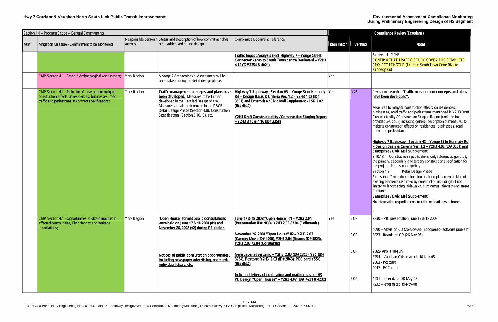
CMP Section 4.1 - Stage 2 Archaeological Assessment;
York Region A Stage 2 Archaeological Assessment will be undertaken during the detail design phase.
Yes
CMP Section 4.1 - Inclusion of measures to mitigate construction effects on residences, businesses, road traffic and pedestrians in contract specifications;
York Region Traffic management concepts and plans have been developed. Measures to be further developed in the Detailed Design phase. Measures are also referenced in the DBCR: Detail Design Phase (Section 4.8), Construction Specifications (Section 3.10.13), etc.
Highway 7 Rapidway - Section H3 – Yonge St to Kennedy Rd – Design Basis & Criteria Ver. 1.2 – Y2H3 4.02 (ID# 3551) and Enterprise / Civic Mall Supplement - ESP 3.02 (ID# 4040) Y2H3 Draft Constructability / Construction Staging Report – Y2H3 3.16 & 4.16 (ID# 3358)
Yes NSE
It was not clear that “Traffic management concepts and plans have been developed”. Measures to mitigate construction effects on residences, businesses, road traffic and pedestrians mentioned in Y2H3 Draft Constructability / Construction Staging Report (undated but provided 3-Oct-08) including general description of measures to mitigate construction effects on residences, businesses, road traffic and pedestrians Highway 7 Rapidway - Section H3 – Yonge St to Kennedy Rd – Design Basis & Criteria Ver. 1.2 – Y2H3 4.02 (ID# 3551) and Enterprise / Civic Mall Supplement ) 3.10.13 Construction Specifications only references generally the primary, secondary and tertiary construction specification for the project It does not expclicty Section 4.8 Detail Design Phase States that “Protection, relocation and or replacement in kind of existing elements disturbed by construction including but not limited to landscaping, sidewalks, curb ramps, shelters and street furniture” Enterprise / Civic Mall Supplement ) No information regarding construction mitigation was found I
CMP Section 4.1 - Opportunities to obtain input from affected communities, First Nations and heritage associations;
York Region “Open House” format public consultations were held on June 17 & 18 2008 (#1) and November 26, 2008 (#2) during PE design. Notices of public consultation opportunities, including newspaper advertising, postcards, individual letters, etc.
June 17 & 18 2008 “Open House” #1 – Y2H3 2.04 (Presentation ID# 2830), Y2H3 2.03 / 2.04 (Collaterals) November 26, 2008 “Open House” #2 – Y2H3 2.03 (Canopy Movie ID# 4090), Y2H3 2.04 (Boards ID# 3823), Y2H3 2.03 / 2.04 (Collaterals) Newspaper advertising – Y2H3 2.03 (ID# 2865), YSS (ID# 3754), Postcard Y2H3 2.03 (ID# 2863), PCC card YSSC (ID# 4047) Individual letters of notification and mailing lists for H3 PE Design “Open Houses” – Y2H3 4.07 (ID# 4231 & 4232)
Yes ECF ECF ECF ECF
2830 – PIC presentation June 17 & 18 2008 4090 – Movie on CD (26-Nov-08) (not opened- software problem) 3823 - Boards on CD (26-Nov-08) 2865- Article 18-Jun 3754 – Vaughan Citizen Article 16-Nov-05 2863 - Postcard 4047 - PCC card 4231 – letter dated 30-May-08 4232 – letter dated 19-Nov-08
Hwy 7 Corridor & Vaughan North-South Link Public Transit Improvements Environmental Assessment Compliance Monitoring During Preliminary Engineering Design of H3 Segment
12 of 144 P:\Y2H3\4.0 Preliminary Engineering H3\4.07 H3 - Road & Rapidway Design\Hwy 7 EA Compliance Monitoring\Monitoring Document\Hwy 7 EA Compliance Monitoring - H3 + Cedarland - 2009-07-06.doc 7/6/09
Section 4.0 – Program Scope – General Commitments Compliance Review (Ecoplans)
Item Mitigation Measure / Commitment to be Monitored Responsible person / agency
Status and Description of how commitment has been addressed during design
Compliance Document Reference Item match Verified Notes
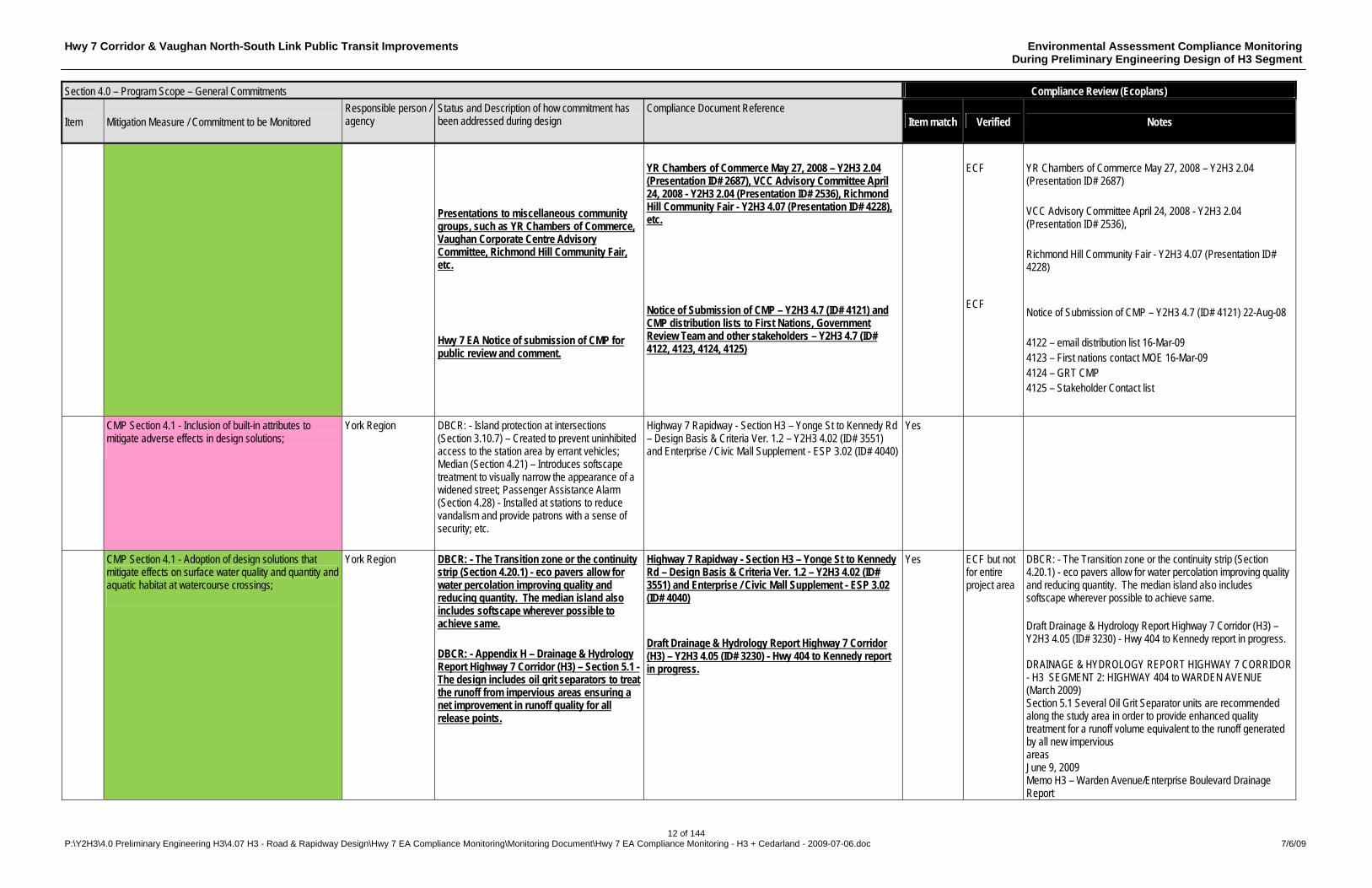
Presentations to miscellaneous community groups, such as YR Chambers of Commerce, Vaughan Corporate Centre Advisory Committee, Richmond Hill Community Fair, etc. Hwy 7 EA Notice of submission of CMP for public review and comment.
YR Chambers of Commerce May 27, 2008 – Y2H3 2.04 (Presentation ID# 2687), VCC Advisory Committee April 24, 2008 - Y2H3 2.04 (Presentation ID# 2536), Richmond Hill Community Fair - Y2H3 4.07 (Presentation ID# 4228), etc. Notice of Submission of CMP – Y2H3 4.7 (ID# 4121) and CMP distribution lists to First Nations, Government Review Team and other stakeholders – Y2H3 4.7 (ID# 4122, 4123, 4124, 4125)
ECF ECF
YR Chambers of Commerce May 27, 2008 – Y2H3 2.04 (Presentation ID# 2687) VCC Advisory Committee April 24, 2008 - Y2H3 2.04 (Presentation ID# 2536), Richmond Hill Community Fair - Y2H3 4.07 (Presentation ID# 4228) Notice of Submission of CMP – Y2H3 4.7 (ID# 4121) 22-Aug-08 4122 – email distribution list 16-Mar-09 4123 – First nations contact MOE 16-Mar-09 4124 – GRT CMP 4125 – Stakeholder Contact list
CMP Section 4.1 - Inclusion of built-in attributes to mitigate adverse effects in design solutions;
York Region DBCR: - Island protection at intersections (Section 3.10.7) – Created to prevent uninhibited access to the station area by errant vehicles; Median (Section 4.21) – Introduces softscape treatment to visually narrow the appearance of a widened street; Passenger Assistance Alarm (Section 4.28) - Installed at stations to reduce vandalism and provide patrons with a sense of security; etc.
Highway 7 Rapidway - Section H3 – Yonge St to Kennedy Rd – Design Basis & Criteria Ver. 1.2 – Y2H3 4.02 (ID# 3551) and Enterprise / Civic Mall Supplement - ESP 3.02 (ID# 4040)
Yes
CMP Section 4.1 - Adoption of design solutions that mitigate effects on surface water quality and quantity and aquatic habitat at watercourse crossings;
York Region DBCR: - The Transition zone or the continuity strip (Section 4.20.1) - eco pavers allow for water percolation improving quality and reducing quantity. The median island also includes softscape wherever possible to achieve same. DBCR: - Appendix H – Drainage & Hydrology Report Highway 7 Corridor (H3) – Section 5.1 - The design includes oil grit separators to treat the runoff from impervious areas ensuring a net improvement in runoff quality for all release points.
Highway 7 Rapidway - Section H3 – Yonge St to Kennedy Rd – Design Basis & Criteria Ver. 1.2 – Y2H3 4.02 (ID# 3551) and Enterprise / Civic Mall Supplement - ESP 3.02 (ID# 4040) Draft Drainage & Hydrology Report Highway 7 Corridor (H3) – Y2H3 4.05 (ID# 3230) - Hwy 404 to Kennedy report in progress.
Yes ECF but not for entire project area
DBCR: - The Transition zone or the continuity strip (Section 4.20.1) - eco pavers allow for water percolation improving quality and reducing quantity. The median island also includes softscape wherever possible to achieve same. Draft Drainage & Hydrology Report Highway 7 Corridor (H3) – Y2H3 4.05 (ID# 3230) - Hwy 404 to Kennedy report in progress. DRAINAGE & HYDROLOGY REPORT HIGHWAY 7 CORRIDOR - H3 SEGMENT 2: HIGHWAY 404 to WARDEN AVENUE (March 2009) Section 5.1 Several Oil Grit Separator units are recommended along the study area in order to provide enhanced quality treatment for a runoff volume equivalent to the runoff generated by all new impervious areas June 9, 2009 Memo H3 – Warden Avenue/Enterprise Boulevard Drainage Report
Hwy 7 Corridor & Vaughan North-South Link Public Transit Improvements Environmental Assessment Compliance Monitoring During Preliminary Engineering Design of H3 Segment
13 of 144 P:\Y2H3\4.0 Preliminary Engineering H3\4.07 H3 - Road & Rapidway Design\Hwy 7 EA Compliance Monitoring\Monitoring Document\Hwy 7 EA Compliance Monitoring - H3 + Cedarland - 2009-07-06.doc 7/6/09
Section 4.0 – Program Scope – General Commitments Compliance Review (Ecoplans)
Item Mitigation Measure / Commitment to be Monitored Responsible person / agency
Status and Description of how commitment has been addressed during design
Compliance Document Reference Item match Verified Notes
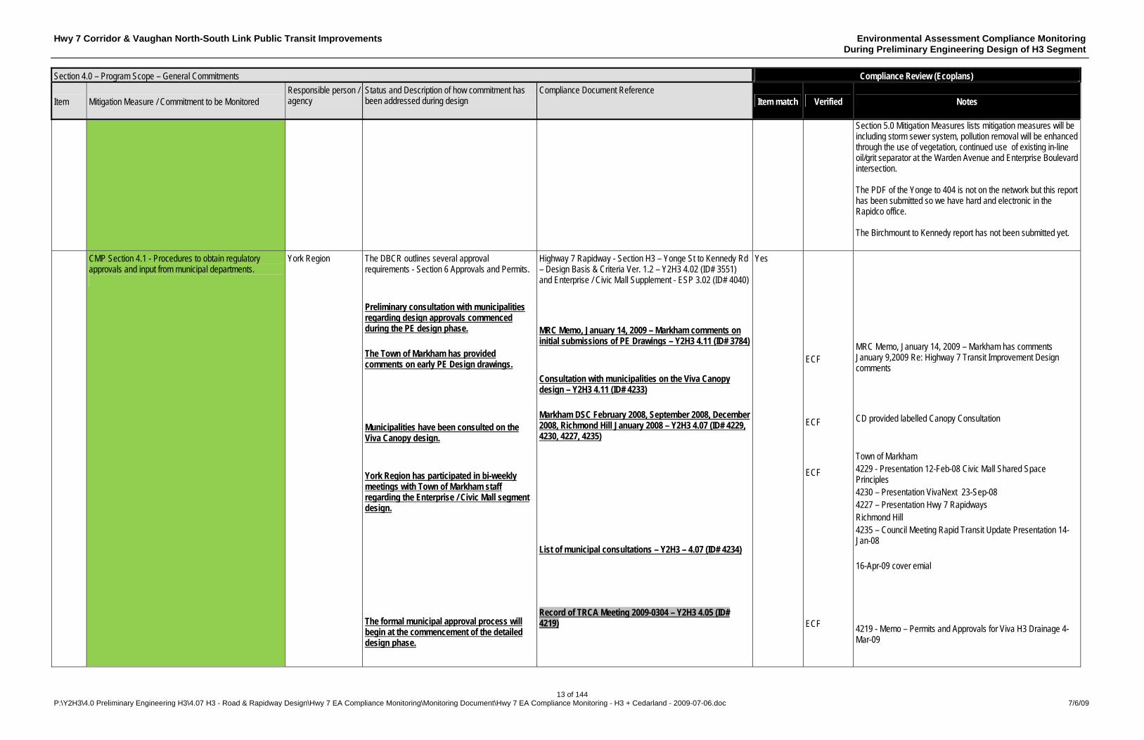
Section 5.0 Mitigation Measures lists mitigation measures will be including storm sewer system, pollution removal will be enhanced through the use of vegetation, continued use of existing in-line oil/grit separator at the Warden Avenue and Enterprise Boulevard intersection.
The PDF of the Yonge to 404 is not on the network but this report has been submitted so we have hard and electronic in the Rapidco office. The Birchmount to Kennedy report has not been submitted yet.
CMP Section 4.1 - Procedures to obtain regulatory approvals and input from municipal departments.
York Region The DBCR outlines several approval requirements - Section 6 Approvals and Permits. Preliminary consultation with municipalities regarding design approvals commenced during the PE design phase. The Town of Markham has provided comments on early PE Design drawings. Municipalities have been consulted on the Viva Canopy design. York Region has participated in bi-weekly meetings with Town of Markham staff regarding the Enterprise / Civic Mall segment design. The formal municipal approval process will begin at the commencement of the detailed design phase.
Highway 7 Rapidway - Section H3 – Yonge St to Kennedy Rd – Design Basis & Criteria Ver. 1.2 – Y2H3 4.02 (ID# 3551) and Enterprise / Civic Mall Supplement - ESP 3.02 (ID# 4040) MRC Memo, January 14, 2009 – Markham comments on initial submissions of PE Drawings – Y2H3 4.11 (ID# 3784) Consultation with municipalities on the Viva Canopy design – Y2H3 4.11 (ID# 4233) Markham DSC February 2008, September 2008, December 2008, Richmond Hill January 2008 – Y2H3 4.07 (ID# 4229, 4230, 4227, 4235) List of municipal consultations – Y2H3 – 4.07 (ID# 4234) Record of TRCA Meeting 2009-0304 – Y2H3 4.05 (ID# 4219)
Yes ECF ECF ECF ECF
MRC Memo, January 14, 2009 – Markham has comments January 9,2009 Re: Highway 7 Transit Improvement Design comments CD provided labelled Canopy Consultation Town of Markham 4229 - Presentation 12-Feb-08 Civic Mall Shared Space Principles 4230 – Presentation VivaNext 23-Sep-08 4227 – Presentation Hwy 7 Rapidways Richmond Hill 4235 – Council Meeting Rapid Transit Update Presentation 14-Jan-08 16-Apr-09 cover emial 4219 - Memo – Permits and Approvals for Viva H3 Drainage 4-Mar-09
Hwy 7 Corridor & Vaughan North-South Link Public Transit Improvements Environmental Assessment Compliance Monitoring During Preliminary Engineering Design of H3 Segment
14 of 144 P:\Y2H3\4.0 Preliminary Engineering H3\4.07 H3 - Road & Rapidway Design\Hwy 7 EA Compliance Monitoring\Monitoring Document\Hwy 7 EA Compliance Monitoring - H3 + Cedarland - 2009-07-06.doc 7/6/09
Section 4.0 – Program Scope – General Commitments Compliance Review (Ecoplans)
Item Mitigation Measure / Commitment to be Monitored Responsible person / agency
Status and Description of how commitment has been addressed during design
Compliance Document Reference Item match Verified Notes
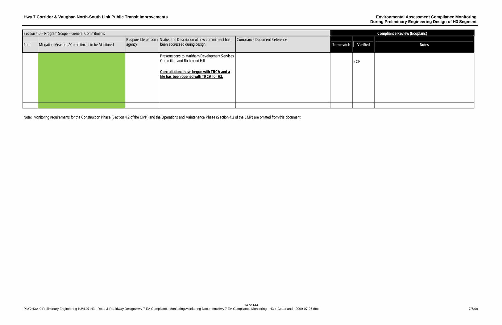
Presentations to Markham Development Services Committee and Richmond Hill Consultations have begun with TRCA and a file has been opened with TRCA for H3.
ECF
Note: Monitoring requirements for the Construction Phase (Section 4.2 of the CMP) and the Operations and Maintenance Phase (Section 4.3 of the CMP) are omitted from this document
Hwy 7 Corridor & Vaughan North-South Link Public Transit Improvements Environmental Assessment Compliance Monitoring During Preliminary Engineering Design of H3 Segment
15 of 144 P:\Y2H3\4.0 Preliminary Engineering H3\4.07 H3 - Road & Rapidway Design\Hwy 7 EA Compliance Monitoring\Monitoring Document\Hwy 7 EA Compliance Monitoring - H3 + Cedarland - 2009-07-06.doc 7/6/09
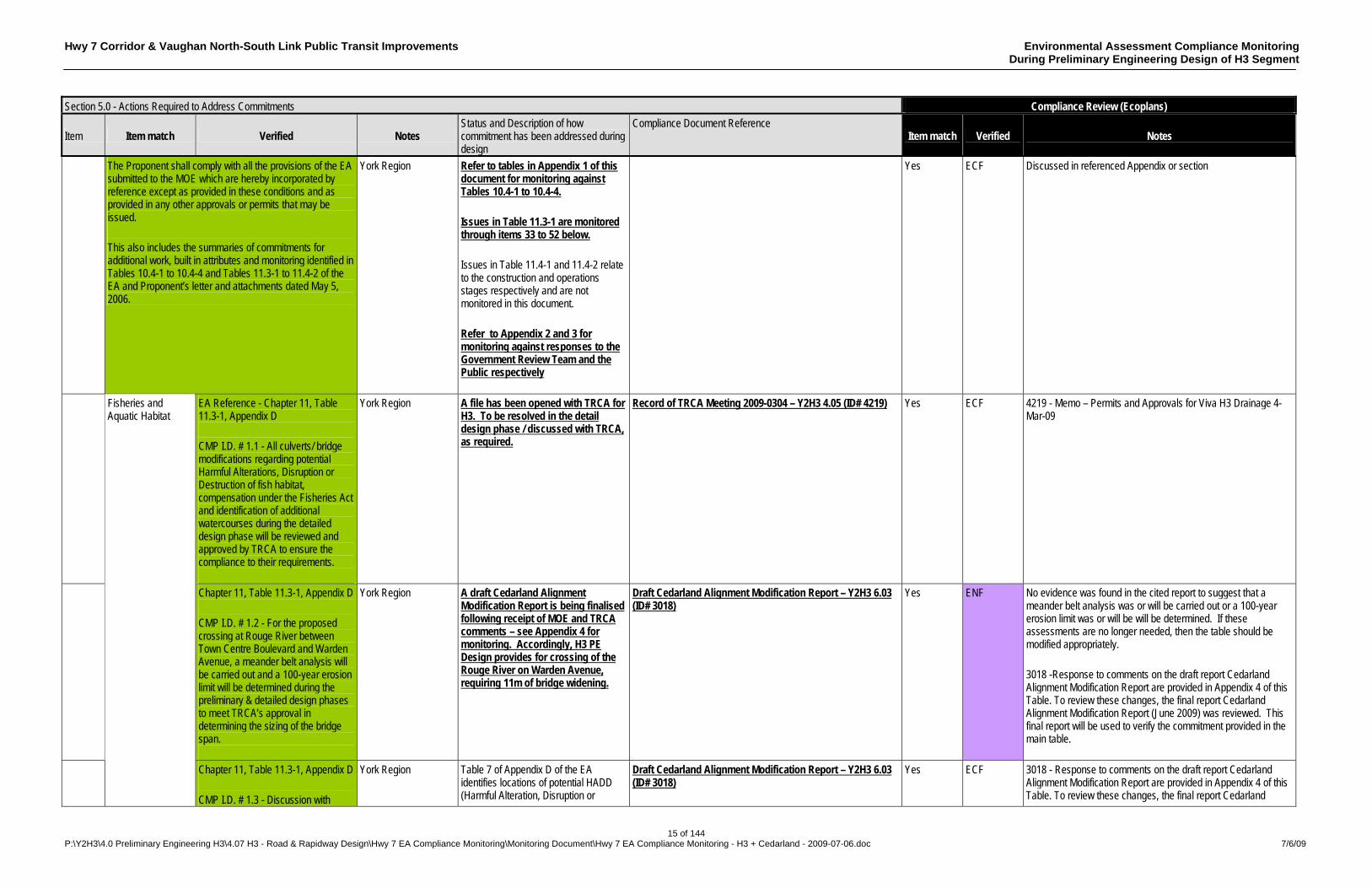
Section 5.0 - Actions Required to Address Commitments Compliance Review (Ecoplans)
Item Item match Verified Notes Status and Description of how commitment has been addressed during design
Compliance Document Reference Item match Verified Notes
The Proponent shall comply with all the provisions of the EA submitted to the MOE which are hereby incorporated by reference except as provided in these conditions and as provided in any other approvals or permits that may be issued. This also includes the summaries of commitments for additional work, built in attributes and monitoring identified in Tables 10.4-1 to 10.4-4 and Tables 11.3-1 to 11.4-2 of the EA and Proponent’s letter and attachments dated May 5, 2006.
York Region Refer to tables in Appendix 1 of this document for monitoring against Tables 10.4-1 to 10.4-4. Issues in Table 11.3-1 are monitored through items 33 to 52 below. Issues in Table 11.4-1 and 11.4-2 relate to the construction and operations stages respectively and are not monitored in this document. Refer to Appendix 2 and 3 for monitoring against responses to the Government Review Team and the Public respectively
Yes ECF Discussed in referenced Appendix or section
EA Reference - Chapter 11, Table 11.3-1, Appendix D CMP I.D. # 1.1 - All culverts/ bridge modifications regarding potential Harmful Alterations, Disruption or Destruction of fish habitat, compensation under the Fisheries Act and identification of additional watercourses during the detailed design phase will be reviewed and approved by TRCA to ensure the compliance to their requirements.
York Region A file has been opened with TRCA for H3. To be resolved in the detail design phase / discussed with TRCA, as required.
Record of TRCA Meeting 2009-0304 – Y2H3 4.05 (ID# 4219) Yes ECF 4219 - Memo – Permits and Approvals for Viva H3 Drainage 4-Mar-09
Chapter 11, Table 11.3-1, Appendix D CMP I.D. # 1.2 - For the proposed crossing at Rouge River between Town Centre Boulevard and Warden Avenue, a meander belt analysis will be carried out and a 100-year erosion limit will be determined during the preliminary & detailed design phases to meet TRCA’s approval in determining the sizing of the bridge span.
York Region A draft Cedarland Alignment Modification Report is being finalised following receipt of MOE and TRCA comments – see Appendix 4 for monitoring. Accordingly, H3 PE Design provides for crossing of the Rouge River on Warden Avenue, requiring 11m of bridge widening.
Draft Cedarland Alignment Modification Report – Y2H3 6.03 (ID# 3018)
Yes ENF No evidence was found in the cited report to suggest that a meander belt analysis was or will be carried out or a 100-year erosion limit was or will be will be determined. If these assessments are no longer needed, then the table should be modified appropriately. 3018 -Response to comments on the draft report Cedarland Alignment Modification Report are provided in Appendix 4 of this Table. To review these changes, the final report Cedarland Alignment Modification Report (June 2009) was reviewed. This final report will be used to verify the commitment provided in the main table.
Fisheries and Aquatic Habitat
Chapter 11, Table 11.3-1, Appendix D CMP I.D. # 1.3 - Discussion with
York Region Table 7 of Appendix D of the EA identifies locations of potential HADD (Harmful Alteration, Disruption or
Draft Cedarland Alignment Modification Report – Y2H3 6.03 (ID# 3018)
Yes ECF 3018 - Response to comments on the draft report Cedarland Alignment Modification Report are provided in Appendix 4 of this Table. To review these changes, the final report Cedarland

Hwy 7 Corridor & Vaughan North-South Link Public Transit Improvements Environmental Assessment Compliance Monitoring During Preliminary Engineering Design of H3 Segment
16 of 144 P:\Y2H3\4.0 Preliminary Engineering H3\4.07 H3 - Road & Rapidway Design\Hwy 7 EA Compliance Monitoring\Monitoring Document\Hwy 7 EA Compliance Monitoring - H3 + Cedarland - 2009-07-06.doc 7/6/09
Section 5.0 - Actions Required to Address Commitments Compliance Review (Ecoplans)
Item Item match Verified Notes Status and Description of how commitment has been addressed during design
Compliance Document Reference Item match Verified Notes
TRCA carried out to determine if a HADD will occur at one culvert extension, and if so, to secure a Fisheries Act authorization.
Destruction of fish habitat). The draft Cedarland Alignment Modification Report has identified a potential HADD associated with the Warden Avenue bridge widening – see Appendix 4 for monitoring. To be resolved in the detail design phase / discussed with TRCA, as required. No HADD was identified during the detail design of Phase 1 of the Enterprise / Civic Mall section west of Birchmount Avenue.
Alignment Modification Report (June 2009) was reviewed. This final report will be used to verify the commitment provided in the main table.
Chapter 11, Table 11.3-1, Appendix D CMP I.D. # 1.4 - Any proposed in-stream work and site-specific mitigation measures carried out as outlined in Table 7 of the Natural Science Report
York Region Provision for site-specific measures will be made in the detailed design phase. No in-stream work was identified during the detail design of Phase 1 of the Enterprise / Civic Mall section west of Birchmount Avenue. DBCR: - (Page 131) - “Notes for Design Consideration” indicates “Erosion Control protection shall be designed at all culverts, storm sewers inlets/outlets and ditch inlets/outlets”.
Highway 7 Rapidway - Section H3 – Yonge St to Kennedy Rd – Design Basis & Criteria Ver. 1.2 – Y2H3 4.02 (ID# 3551) and Enterprise / Civic Mall Supplement - ESP 3.02 (ID# 4040)
Yes
Vegetation and Wetlands
Chapter 11, Table 11.3-1, Appendix D CMP I.D. # 3.1 - Edge Management Plan and Tree Preservation Plans will be prepared during the detailed design to mitigate impacts to adjacent natural features, as well as the preparation of detailed compensation and restoration plans to strive to provide for a net improvement to existing condition. TRCA guidelines for Forest Edge Management Plans and Post-Construction Restoration will be followed.
York Region Edge Management Plan, Tree Preservation Plans and compensation and restoration plans will be prepared during the detailed design phase, as required.
Yes
Groundwater Chapter 11, Table 11.3-1, Appendix D York Region To be addressed during design and Yes
Hwy 7 Corridor & Vaughan North-South Link Public Transit Improvements Environmental Assessment Compliance Monitoring During Preliminary Engineering Design of H3 Segment
17 of 144 P:\Y2H3\4.0 Preliminary Engineering H3\4.07 H3 - Road & Rapidway Design\Hwy 7 EA Compliance Monitoring\Monitoring Document\Hwy 7 EA Compliance Monitoring - H3 + Cedarland - 2009-07-06.doc 7/6/09
Section 5.0 - Actions Required to Address Commitments Compliance Review (Ecoplans)
Item Item match Verified Notes Status and Description of how commitment has been addressed during design
Compliance Document Reference Item match Verified Notes
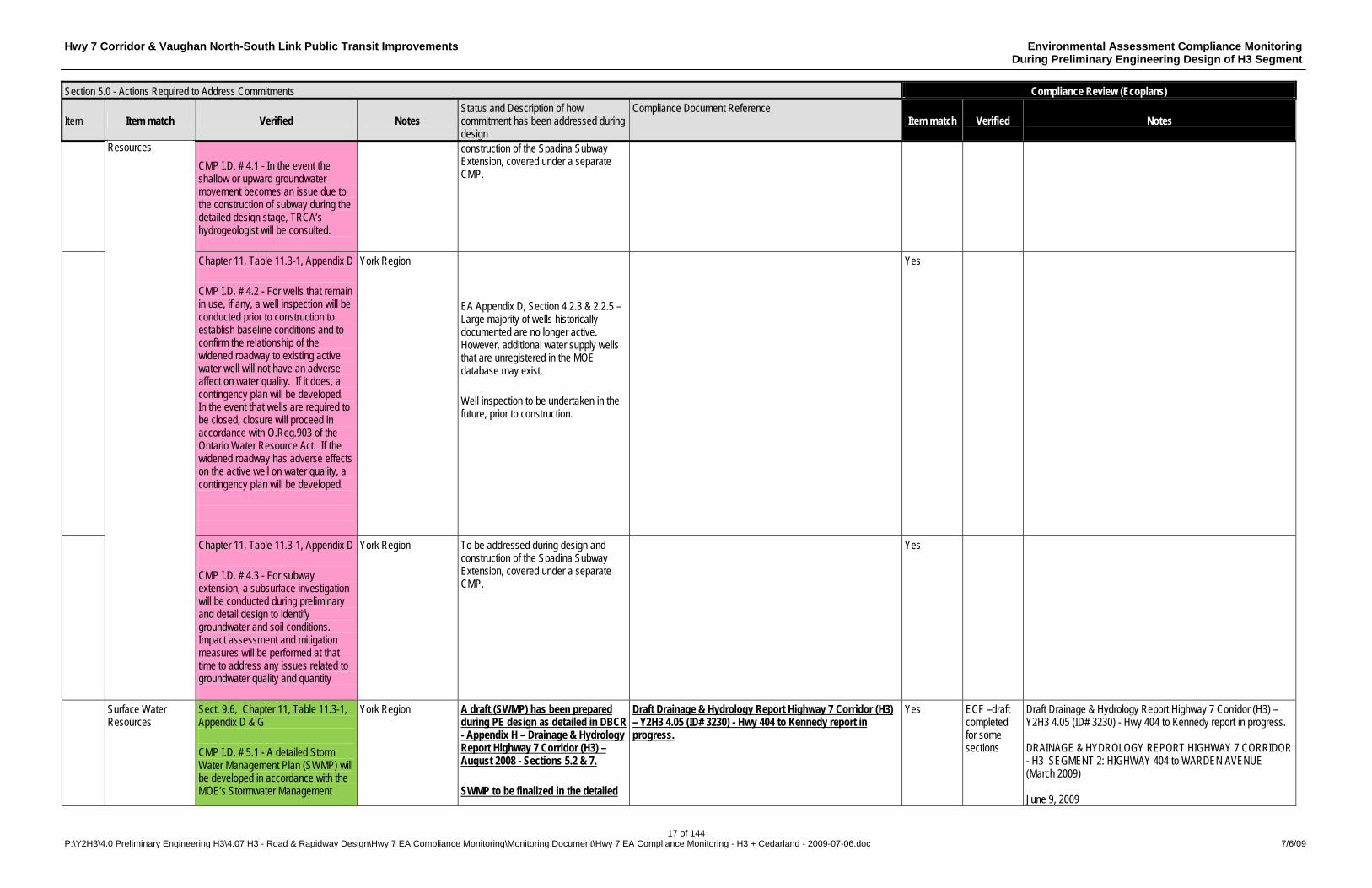
CMP I.D. # 4.1 - In the event the shallow or upward groundwater movement becomes an issue due to the construction of subway during the detailed design stage, TRCA’s hydrogeologist will be consulted.
construction of the Spadina Subway Extension, covered under a separate CMP.
Chapter 11, Table 11.3-1, Appendix D CMP I.D. # 4.2 - For wells that remain in use, if any, a well inspection will be conducted prior to construction to establish baseline conditions and to confirm the relationship of the widened roadway to existing active water well will not have an adverse affect on water quality. If it does, a contingency plan will be developed. In the event that wells are required to be closed, closure will proceed in accordance with O.Reg.903 of the Ontario Water Resource Act. If the widened roadway has adverse effects on the active well on water quality, a contingency plan will be developed.
York Region EA Appendix D, Section 4.2.3 & 2.2.5 – Large majority of wells historically documented are no longer active. However, additional water supply wells that are unregistered in the MOE database may exist. Well inspection to be undertaken in the future, prior to construction.
Yes
Resources
Chapter 11, Table 11.3-1, Appendix D CMP I.D. # 4.3 - For subway extension, a subsurface investigation will be conducted during preliminary and detail design to identify groundwater and soil conditions. Impact assessment and mitigation measures will be performed at that time to address any issues related to groundwater quality and quantity
York Region To be addressed during design and construction of the Spadina Subway Extension, covered under a separate CMP.
Yes
Surface Water Resources
Sect. 9.6, Chapter 11, Table 11.3-1, Appendix D & G CMP I.D. # 5.1 - A detailed Storm Water Management Plan (SWMP) will be developed in accordance with the MOE’s Stormwater Management
York Region A draft (SWMP) has been prepared during PE design as detailed in DBCR - Appendix H – Drainage & Hydrology Report Highway 7 Corridor (H3) – August 2008 - Sections 5.2 & 7. SWMP to be finalized in the detailed
Draft Drainage & Hydrology Report Highway 7 Corridor (H3) – Y2H3 4.05 (ID# 3230) - Hwy 404 to Kennedy report in progress.
Yes ECF –draft completed for some sections
Draft Drainage & Hydrology Report Highway 7 Corridor (H3) – Y2H3 4.05 (ID# 3230) - Hwy 404 to Kennedy report in progress. DRAINAGE & HYDROLOGY REPORT HIGHWAY 7 CORRIDOR - H3 SEGMENT 2: HIGHWAY 404 to WARDEN AVENUE (March 2009) June 9, 2009
Hwy 7 Corridor & Vaughan North-South Link Public Transit Improvements Environmental Assessment Compliance Monitoring During Preliminary Engineering Design of H3 Segment
18 of 144 P:\Y2H3\4.0 Preliminary Engineering H3\4.07 H3 - Road & Rapidway Design\Hwy 7 EA Compliance Monitoring\Monitoring Document\Hwy 7 EA Compliance Monitoring - H3 + Cedarland - 2009-07-06.doc 7/6/09
Section 5.0 - Actions Required to Address Commitments Compliance Review (Ecoplans)
Item Item match Verified Notes Status and Description of how commitment has been addressed during design
Compliance Document Reference Item match Verified Notes
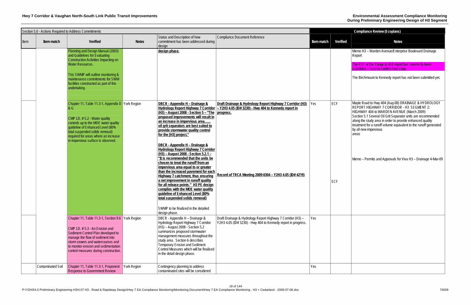
Planning and Design Manual (2003) and Guidelines for Evaluating Construction Activities Impacting on Water Resources. This SWMP will outline monitoring & maintenance commitments for SWM facilities constructed as part of this undertaking.
design phase.
Memo H3 – Warden Avenue/Enterprise Boulevard Drainage Report The PDF of the Yonge to 404 report has reportedly been submitted – need to confirm hard copy The Birchmount to Kennedy report has not been submitted yet.
Chapter 11, Table 11.3-1, Appendix D & G CMP I.D. # 5.2 - Water quality controls up to the MOE water quality guideline of Enhanced Level (80% total suspended solids removal) required for areas where an increase in impervious surface is observed.
York Region DBCR - Appendix H – Drainage & Hydrology Report Highway 7 Corridor (H3) – August 2008 - Section 5 – “The proposed improvements will result in an increase in impervious area…… oil grit separators are best suited to provide stormwater quality control for the [H3] project.” DBCR - Appendix H – Drainage & Hydrology Report Highway 7 Corridor (H3) – August 2008 - Section 5.2.1 – “It is recommended that the units be chosen to treat the runoff from an impervious area equal to or greater than the increased pavement for each Highway 7 catchment, thus ensuring a net improvement in runoff quality for all release points.” H3 PE design complies with the MOE water quality guideline of Enhanced Level (80% total suspended solids removal) SWMP to be finalized in the detailed design phase.
Draft Drainage & Hydrology Report Highway 7 Corridor (H3) – Y2H3 4.05 (ID# 3230) - Hwy 404 to Kennedy report in progress. Record of TRCA Meeting 2009-0304 – Y2H3 4.05 (ID# 4219)
Yes ECF ECF
Maple Road to Hwy 404 (Aug-08) DRAINAGE & HYDROLOGY REPORT HIGHWAY 7 CORRIDOR - H3 SEGMENT 2: HIGHWAY 404 to WARDEN AVENUE (March 2009) Section 5.1 Several Oil Grit Separator units are recommended along the study area in order to provide enhanced quality treatment for a runoff volume equivalent to the runoff generated by all new impervious areas Memo – Permits and Approvals for Viva H3 – Drainage 4-Mar-09
Chapter 11, Table 11.3-1, Section 9.6 CMP I.D. # 5.3 - An Erosion and Sediment Control Plan developed to manage the flow of sediment into storm sewers and watercourses and to monitor erosion and sedimentation control measures during construction.
York Region DBCR - Appendix H – Drainage & Hydrology Report Highway 7 Corridor (H3) – August 2008 - Section 5.2 summarizes proposed stormwater management measures throughout the study area. Section 6 describes Temporary Erosion and Sediment Control Measures which will be finalized in the detail design phase.
Draft Drainage & Hydrology Report Highway 7 Corridor (H3) – Y2H3 4.05 (ID# 3230) - Hwy 404 to Kennedy report in progress.
Yes
Contaminated Soil Chapter 11, Table 11.3-1, Proponent Response to Government Review
York Region Contingency planning to address contaminated sites will be considered
Yes
Hwy 7 Corridor & Vaughan North-South Link Public Transit Improvements Environmental Assessment Compliance Monitoring During Preliminary Engineering Design of H3 Segment
19 of 144 P:\Y2H3\4.0 Preliminary Engineering H3\4.07 H3 - Road & Rapidway Design\Hwy 7 EA Compliance Monitoring\Monitoring Document\Hwy 7 EA Compliance Monitoring - H3 + Cedarland - 2009-07-06.doc 7/6/09
Section 5.0 - Actions Required to Address Commitments Compliance Review (Ecoplans)
Item Item match Verified Notes Status and Description of how commitment has been addressed during design
Compliance Document Reference Item match Verified Notes
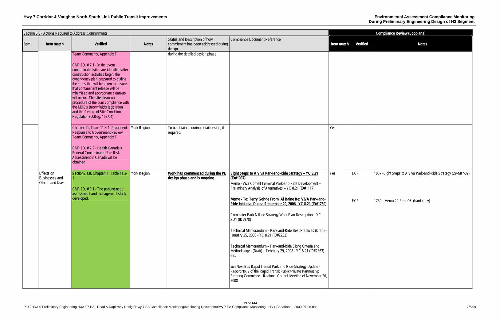
Team Comments, Appendix F CMP I.D. # 7.1 - In the event contaminated sites are identified after construction activities begin, the contingency plan prepared to outline the steps that will be taken to ensure that contaminant release will be minimized and appropriate clean-up will occur. The site clean-up procedure of the plan compliance with the MOE’s Brownfield’s legislation and the Record of Site Condition Regulation (O.Reg. 153/04)
during the detailed design phase.
Chapter 11, Table 11.3-1, Proponent Response to Government Review Team Comments, Appendix F CMP I.D. # 7.2 - Health Canada’s Federal Contaminated Site Risk Assessment in Canada will be obtained
York Region To be obtained during detail design, if required.
Yes
Effects on Businesses and Other Land Uses
Section9.1.8, Chapter11, Table 11.3-1 CMP I.D. # 9.1 - The parking need assessment and management study developed.
York Region Work has commenced during the PE design phase and is ongoing.
Eight Steps to A Viva Park-and-Ride Strategy – YC 8.21 (ID#1037) Memo - Viva Cornell Terminal Park-and-Ride Development – Preliminary Analysis of Alternatives – YC 8.21 (ID#1117) Memo - To: Terry Gohde From: Al Raine Re: VIVA Park-and-Ride Initiative Dates: September 29, 2006 –YC 8.21 (ID#1739) Commuter Park N Ride Strategy Work Plan Description – YC 8.21 (ID#978) Technical Memorandum – Park-and-Ride Best Practices (Draft) – January 25, 2008 - YC 8.21 (ID#2232) Technical Memorandum – Park-and-Ride Siting Criteria and Methodology - (Draft) – February 29, 2008 - YC 8.21 (ID#2363) – etc. vivaNext Bus Rapid Transit Park and Ride Strategy Update - Report No. 9 of the Rapid Transit Public/Private Partnership Steering Committee - Regional Council Meeting of November 20, 2008
Yes ECF ECF
1037 -Eight Steps to A Viva Park-and-Ride Strategy (29-Mar-09) 1739 - Memo 29-Sep- 06 (hard copy)
Hwy 7 Corridor & Vaughan North-South Link Public Transit Improvements Environmental Assessment Compliance Monitoring During Preliminary Engineering Design of H3 Segment
20 of 144 P:\Y2H3\4.0 Preliminary Engineering H3\4.07 H3 - Road & Rapidway Design\Hwy 7 EA Compliance Monitoring\Monitoring Document\Hwy 7 EA Compliance Monitoring - H3 + Cedarland - 2009-07-06.doc 7/6/09
Section 5.0 - Actions Required to Address Commitments Compliance Review (Ecoplans)
Item Item match Verified Notes Status and Description of how commitment has been addressed during design
Compliance Document Reference Item match Verified Notes
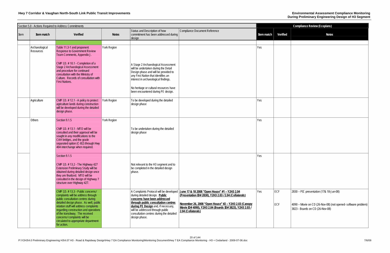
Archaeological
Resources Table 11.3-1 and proponent Response to Government Review Team Comments, Appendix J. CMP I.D. # 10.1 - Completion of a Stage 2 Archaeological Assessment and procedure for continued consultation with the Ministry of Culture. Records of consultation with First Nations.
York Region A Stage 2 Archaeological Assessment will be undertaken during the Detail Design phase and will be provided to any First Nation that identifies an interest in archaeological findings. No heritage or cultural resources have been encountered during PE design.
Yes
Agriculture
CMP I.D. # 12.1 - A policy to protect agriculture lands during construction will be developed during the detailed design phase.
York Region To be developed during the detailed design phase
Yes
Section 9.1.5 CMP I.D. # 13.1 - MTO will be consulted and their approval will be sought in any modifications to the CAH bridges, and the grade separated option (C-B2) through Hwy 404 interchange when required.
York Region To be undertaken during the detailed design phase
Yes
Section 9.1.5 CMP I.D. # 13.2 - The Highway 427 Extension Preliminary Study will be obtained during detailed design once they are finalized. MTO will be consulted in the design of Highway 7 structure over Highway 427.
Not relevant to the H3 segment and to be completed in the detailed design phase.
Yes
Others
CMP I.D. # 13.3 - Public concerns/ complaints will be address through public consultation centres during detailed design phase. As well, public relation stuff will address complaints regarding construction and operations of the transitway. The received concerns/ complaints will be circulated to appropriate department for action.
A Complaints Protocol will be developed during detailed design. Public concerns have been addressed through public consultation centres during PE Design and, if necessary, will be addressed through public consultation centres during the detailed design phase.
June 17 & 18 2008 “Open House” #1 – Y2H3 2.04 (Presentation ID# 2830), Y2H3 2.03 / 2.04 (Collaterals) November 26, 2008 “Open House” #2 – Y2H3 2.03 (Canopy Movie ID# 4090), Y2H3 2.04 (Boards ID# 3823), Y2H3 2.03 / 2.04 (Collaterals)
Yes ECF ECF
2830 – PIC presentation (17& 18-Jun-08) 4090 – Movie on CD (26-Nov-08) (not opened- software problem) 3823 - Boards on CD (26-Nov-08)
Hwy 7 Corridor & Vaughan North-South Link Public Transit Improvements Environmental Assessment Compliance Monitoring During Preliminary Engineering Design of H3 Segment
21 of 144 P:\Y2H3\4.0 Preliminary Engineering H3\4.07 H3 - Road & Rapidway Design\Hwy 7 EA Compliance Monitoring\Monitoring Document\Hwy 7 EA Compliance Monitoring - H3 + Cedarland - 2009-07-06.doc 7/6/09
Section 5.0 - Actions Required to Address Commitments Compliance Review (Ecoplans)
Item Item match Verified Notes Status and Description of how commitment has been addressed during design
Compliance Document Reference Item match Verified Notes
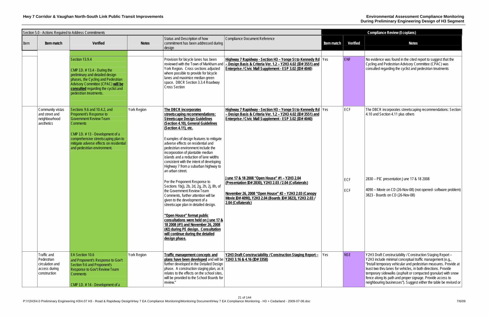
Section 13.9.4
CMP I.D. # 13.4 - During the preliminary and detailed design phases, the Cycling and Pedestrian Advisory Committee (CPAC) will be consulted regarding the cyclist and pedestrian treatments.
Provision for bicycle lanes has been reviewed with the Town of Markham and York Region. Cross sections adjusted where possible to provide for bicycle lanes and maximize median green space. DBCR Section 3.3.4 Roadway Cross Section
Highway 7 Rapidway - Section H3 – Yonge St to Kennedy Rd – Design Basis & Criteria Ver. 1.2 – Y2H3 4.02 (ID# 3551) and Enterprise / Civic Mall Supplement - ESP 3.02 (ID# 4040)
Yes ENF No evidence was found in the cited report to suggest that the Cycling and Pedestrian Advisory Committee (CPAC) was consulted regarding the cyclist and pedestrian treatments
Community vistas and street and neighbourhood aesthetics
Sections 9.6 and 10.4.2, and Proponent’s Response to Government Review Team Comments CMP I.D. # 13 - Development of a comprehensive streetscaping plan to mitigate adverse effects on residential and pedestrian environment.
York Region The DBCR incorporates streetscaping recommendations: Streetscape Design Guidelines (Section 4.10), General Guidelines (Section 4.11), etc. Examples of design features to mitigate adverse effects on residential and pedestrian environment include the incorporation of plantable median islands and a reduction of lane widths consistent with the intent of developing Highway 7 from a suburban highway to an urban street. Per the Proponent Response to Sections 1b(j), 2b, 2d, 2g, 2h, 2j, 8h, of the Government Review Team Comments, further attention will be given to the development of a streetscape plan in detailed design. “Open House” format public consultations were held on June 17 & 18 2008 (#1) and November 26, 2008 (#2) during PE design. Consultation will continue during the detailed design phase.
Highway 7 Rapidway - Section H3 – Yonge St to Kennedy Rd – Design Basis & Criteria Ver. 1.2 – Y2H3 4.02 (ID# 3551) and Enterprise / Civic Mall Supplement - ESP 3.02 (ID# 4040) June 17 & 18 2008 “Open House” #1 – Y2H3 2.04 (Presentation ID# 2830), Y2H3 2.03 / 2.04 (Collaterals) November 26, 2008 “Open House” #2 – Y2H3 2.03 (Canopy Movie ID# 4090), Y2H3 2.04 (Boards ID# 3823), Y2H3 2.03 / 2.04 (Collaterals)
Yes ECF ECF ECF
The DBCR incorporates streetscaping recommendations: Section 4.10 and Section 4.11 plus others 2830 – PIC presentation June 17 & 18 2008 4090 – Movie on CD (26-Nov-08) (not opened- software problem) 3823 - Boards on CD (26-Nov-08)
Traffic and Pedestrian circulation and access during construction
EA Section 10.6 and Proponent’s Response to Gov’t Section 9.6 and Proponent’s Response to Gov’t Review Team Comments CMP I.D. # 14 - Development of a
York Region Traffic management concepts and plans have been developed and will be further developed in the Detailed Design phase. A construction staging plan, as it relates to the effects on the school sites, will be provided to the School Boards for review.”
Y2H3 Draft Constructability / Construction Staging Report – Y2H3 3.16 & 4.16 (ID# 3358)
Yes NSE Y2H3 Draft Constructability / Construction Staging Report – Y2H3 include minimal conceptual traffic management (e.g., “Install temporary vehicular and pedestrian measures. Provide at least two thru lanes for vehicles, in both directions. Provide temporary sidewalks (asphalt or compacted granular) with snow fence along its path and proper signage. Provide access to neighbouring businesses”). Suggest either the table be revised or
Hwy 7 Corridor & Vaughan North-South Link Public Transit Improvements Environmental Assessment Compliance Monitoring During Preliminary Engineering Design of H3 Segment
22 of 144 P:\Y2H3\4.0 Preliminary Engineering H3\4.07 H3 - Road & Rapidway Design\Hwy 7 EA Compliance Monitoring\Monitoring Document\Hwy 7 EA Compliance Monitoring - H3 + Cedarland - 2009-07-06.doc 7/6/09
Section 5.0 - Actions Required to Address Commitments Compliance Review (Ecoplans)
Item Item match Verified Notes Status and Description of how commitment has been addressed during design
Compliance Document Reference Item match Verified Notes
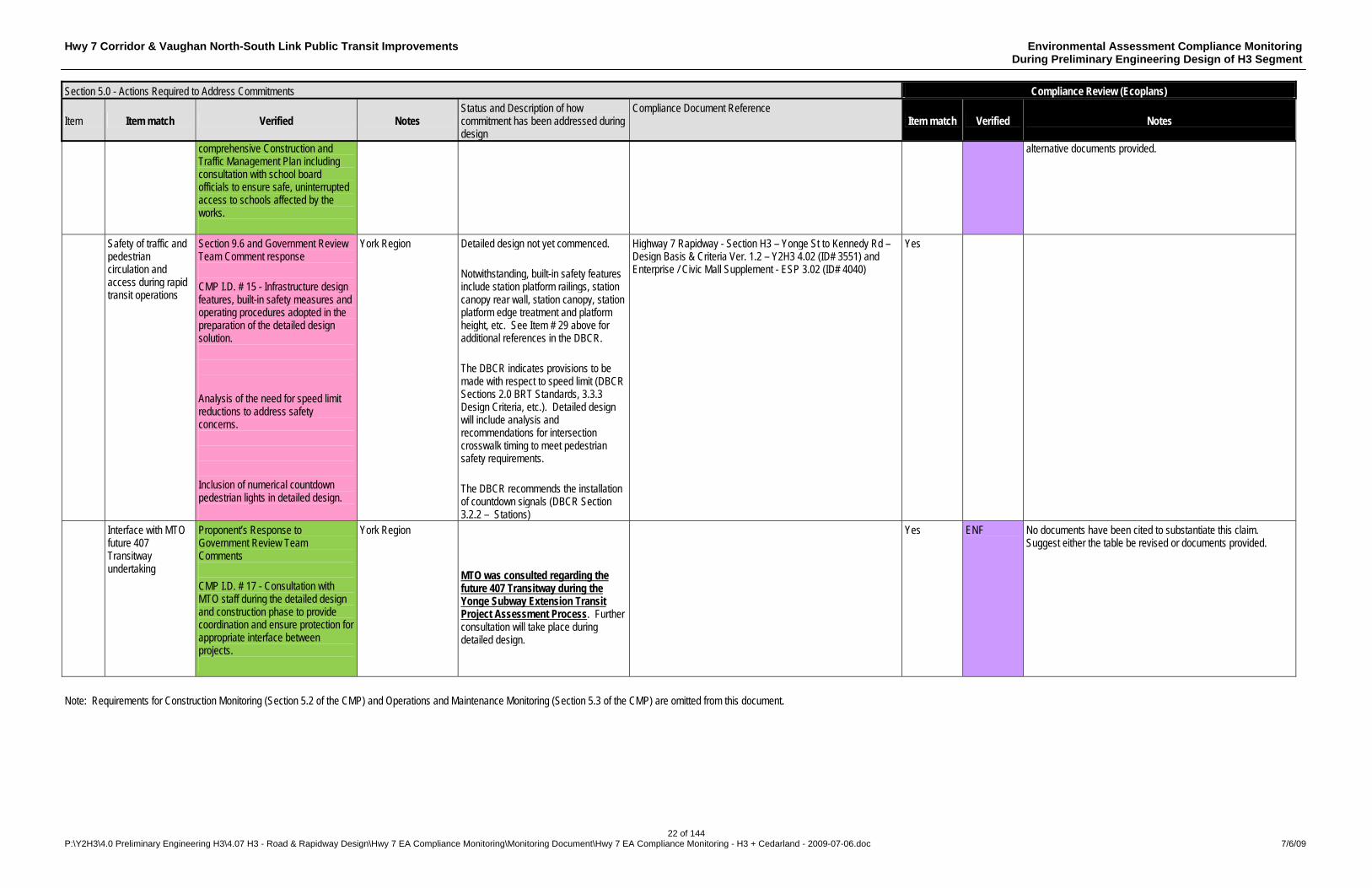
comprehensive Construction and Traffic Management Plan including consultation with school board officials to ensure safe, uninterrupted access to schools affected by the works.
alternative documents provided.
Safety of traffic and pedestrian circulation and access during rapid transit operations
Section 9.6 and Government Review Team Comment response CMP I.D. # 15 - Infrastructure design features, built-in safety measures and operating procedures adopted in the preparation of the detailed design solution. Analysis of the need for speed limit reductions to address safety concerns. Inclusion of numerical countdown pedestrian lights in detailed design.
York Region Detailed design not yet commenced. Notwithstanding, built-in safety features include station platform railings, station canopy rear wall, station canopy, station platform edge treatment and platform height, etc. See Item # 29 above for additional references in the DBCR. The DBCR indicates provisions to be made with respect to speed limit (DBCR Sections 2.0 BRT Standards, 3.3.3 Design Criteria, etc.). Detailed design will include analysis and recommendations for intersection crosswalk timing to meet pedestrian safety requirements. The DBCR recommends the installation of countdown signals (DBCR Section 3.2.2 – Stations)
Highway 7 Rapidway - Section H3 – Yonge St to Kennedy Rd – Design Basis & Criteria Ver. 1.2 – Y2H3 4.02 (ID# 3551) and Enterprise / Civic Mall Supplement - ESP 3.02 (ID# 4040)
Yes
Interface with MTO future 407 Transitway undertaking
Proponent’s Response to Government Review Team Comments CMP I.D. # 17 - Consultation with MTO staff during the detailed design and construction phase to provide coordination and ensure protection for appropriate interface between projects.
York Region MTO was consulted regarding the future 407 Transitway during the Yonge Subway Extension Transit Project Assessment Process. Further consultation will take place during detailed design.
Yes ENF No documents have been cited to substantiate this claim. Suggest either the table be revised or documents provided.
Note: Requirements for Construction Monitoring (Section 5.2 of the CMP) and Operations and Maintenance Monitoring (Section 5.3 of the CMP) are omitted from this document.
Hwy 7 Corridor & Vaughan North-South Link Public Transit Improvements Environmental Assessment Compliance Monitoring During Preliminary Engineering Design of H3 Segment
23 of 144 P:\Y2H3\4.0 Preliminary Engineering H3\4.07 H3 - Road & Rapidway Design\Hwy 7 EA Compliance Monitoring\Monitoring Document\Hwy 7 EA Compliance Monitoring - H3 + Cedarland - 2009-07-06.doc 7/6/09
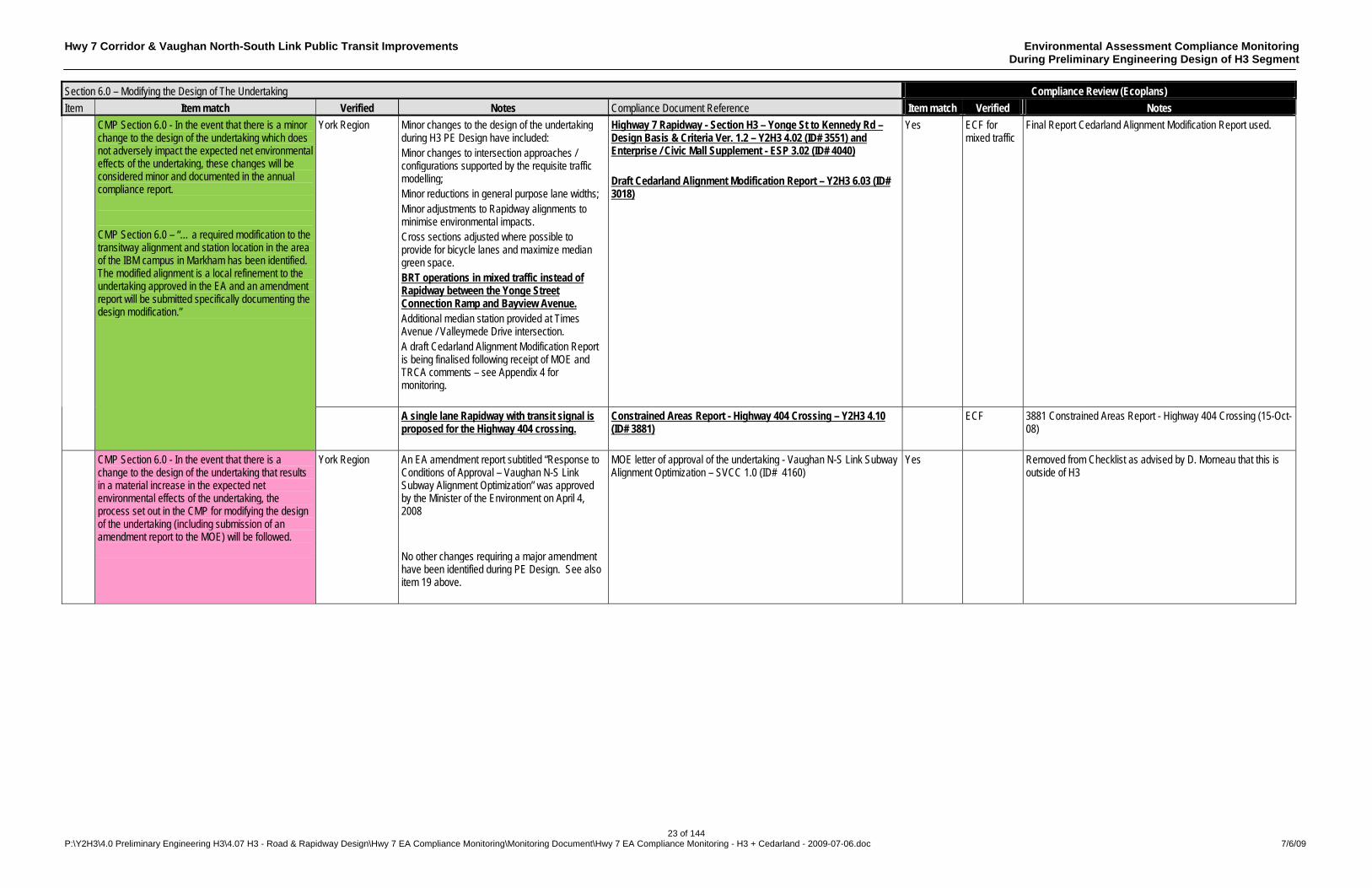
Section 6.0 – Modifying the Design of The Undertaking Compliance Review (Ecoplans)
Item Item match Verified Notes Compliance Document Reference Item match Verified Notes
York Region Minor changes to the design of the undertaking during H3 PE Design have included: Minor changes to intersection approaches / configurations supported by the requisite traffic modelling; Minor reductions in general purpose lane widths; Minor adjustments to Rapidway alignments to minimise environmental impacts. Cross sections adjusted where possible to provide for bicycle lanes and maximize median green space. BRT operations in mixed traffic instead of Rapidway between the Yonge Street Connection Ramp and Bayview Avenue. Additional median station provided at Times Avenue / Valleymede Drive intersection. A draft Cedarland Alignment Modification Report is being finalised following receipt of MOE and TRCA comments – see Appendix 4 for monitoring.
Highway 7 Rapidway - Section H3 – Yonge St to Kennedy Rd – Design Basis & Criteria Ver. 1.2 – Y2H3 4.02 (ID# 3551) and Enterprise / Civic Mall Supplement - ESP 3.02 (ID# 4040) Draft Cedarland Alignment Modification Report – Y2H3 6.03 (ID# 3018)
Yes ECF for mixed traffic
Final Report Cedarland Alignment Modification Report used.
CMP Section 6.0 - In the event that there is a minor change to the design of the undertaking which does not adversely impact the expected net environmental effects of the undertaking, these changes will be considered minor and documented in the annual compliance report. CMP Section 6.0 – “… a required modification to the transitway alignment and station location in the area of the IBM campus in Markham has been identified. The modified alignment is a local refinement to the undertaking approved in the EA and an amendment report will be submitted specifically documenting the design modification.”
A single lane Rapidway with transit signal is proposed for the Highway 404 crossing.
Constrained Areas Report - Highway 404 Crossing – Y2H3 4.10 (ID# 3881)
ECF 3881 Constrained Areas Report - Highway 404 Crossing (15-Oct-08)
CMP Section 6.0 - In the event that there is a change to the design of the undertaking that results in a material increase in the expected net environmental effects of the undertaking, the process set out in the CMP for modifying the design of the undertaking (including submission of an amendment report to the MOE) will be followed.
York Region An EA amendment report subtitled “Response to Conditions of Approval – Vaughan N-S Link Subway Alignment Optimization” was approved by the Minister of the Environment on April 4, 2008 No other changes requiring a major amendment have been identified during PE Design. See also item 19 above.
MOE letter of approval of the undertaking - Vaughan N-S Link Subway Alignment Optimization – SVCC 1.0 (ID# 4160)
Yes Removed from Checklist as advised by D. Morneau that this is outside of H3

Hwy 7 Corridor & Vaughan North-South Link Public Transit Improvements Environmental Assessment Compliance Monitoring During Preliminary Engineering Design of H3 Segment
24 of 144 P:\Y2H3\4.0 Preliminary Engineering H3\4.07 H3 - Road & Rapidway Design\Hwy 7 EA Compliance Monitoring\Monitoring Document\Hwy 7 EA Compliance Monitoring - H3 + Cedarland - 2009-07-06.doc 7/6/09
Section 7.0 – Consultation Compliance Review (Ecoplans)
Item Item match Verified Notes Compliance Document Reference Item match Verified Notes
CMP Section 7.1.1- One “Open House” format public consultation opportunity on completion of the preliminary design development work for each segment of the transitway planned for construction as a stand-alone component of the project implementation. The open house will take place at a location within the limits of the segment to be implemented and the design solution presented and modified as necessary to address public comment, will be the basis for the detailed design.
York Region “Open House” format public consultations were held on June 17 & 18 2008 (Premiere Ballroom and Convention Centre - 9019 Leslie Street) and November 26, 2008 (Premiere Ballroom and Convention Centre - 9019 Leslie Street) during PE design. No design modifications were required to address public comments received at the “Open House” format public consultations.
June 17 & 18 2008 “Open House” #1 – Y2H3 2.04 (Presentation ID# 2830), Y2H3 2.03 / 2.04 (Collaterals) November 26, 2008 “Open House” #2 – Y2H3 2.03 (Canopy Movie ID# 4090), Y2H3 2.04 (Boards ID# 3823), Y2H3 2.03 / 2.04 (Collaterals)
Yes ECF 2830 – PIC presentation June 17 & 18 2008 4090 – Movie on CD (26-Nov-08) (not opened- software problem) 3823 - Boards on CD (26-Nov-08)
CMP Section 7.2.1 - The findings of the Stage 2 Archaeological Assessment and any subsequent assessments will be circulated to all affected stakeholders and First Nations that have asked to be kept informed of the outcome of any archaeological investigations during the design and construction phases.
York Region A Stage 2 Archaeological Assessment will be undertaken during the detail design phase and circulated when completed.
Yes
CMP Section 7.2.1 - The Region and/or designate will consult and respond to First Nations concerns regarding its findings on the Stage 2 Archaeological Assessment. The Region and/or designate will obtain any necessary approvals and conduct any additional studies that may be required as a result of the findings and recommendations of the Stage 2 Assessment.
York Region A Stage 2 Archaeological Assessment will be undertaken during the detail design phase.
Yes
CMP Section 7.2.2 - Notices of public consultation opportunities will be sent to First Nations that wish to be kept informed of the implementation of the undertaking. Should First Nations wish to be kept informed of the study and any additional work the Region will consult and notify First Nations in the manner in which they wish to be notified and/or consulted. This could vary from sending notices to attending meetings.
York Region Hwy 7 EA Notice of submission of CMP for public review and comment. Notices of “Open House” format public consultation opportunities were provided through newspaper advertising.
Notice of Submission of CMP – Y2H3 4.7 (ID# 4121) and CMP distribution lists to First Nations – Y2H3 4.7 (ID# 4123) Newspaper advertising – Y2H3 2.03 (ID# 2865), YSS (ID# 3754)
Yes ECF ECF
4121 - Notice of Submission of CMP 22-Aug-08 4123 – First nations contact MOE 16-Mar-09 2865- Article 18-Jun 3754 – Vaughan Citizen Article 16-Nov-05
Note: Monitoring requirements for the Construction Phase (Section 7.1.2 of the CMP) and the Operations and Maintenance Phase (Section 7.1.3 of the CMP) are omitted from this document
Hwy 7 Corridor & Vaughan North-South Link Public Transit Improvements Environmental Assessment Compliance Monitoring During Preliminary Engineering Design of H3 Segment
25 of 144 P:\Y2H3\4.0 Preliminary Engineering H3\4.07 H3 - Road & Rapidway Design\Hwy 7 EA Compliance Monitoring\Monitoring Document\Hwy 7 EA Compliance Monitoring - H3 + Cedarland - 2009-07-06.doc 7/6/09
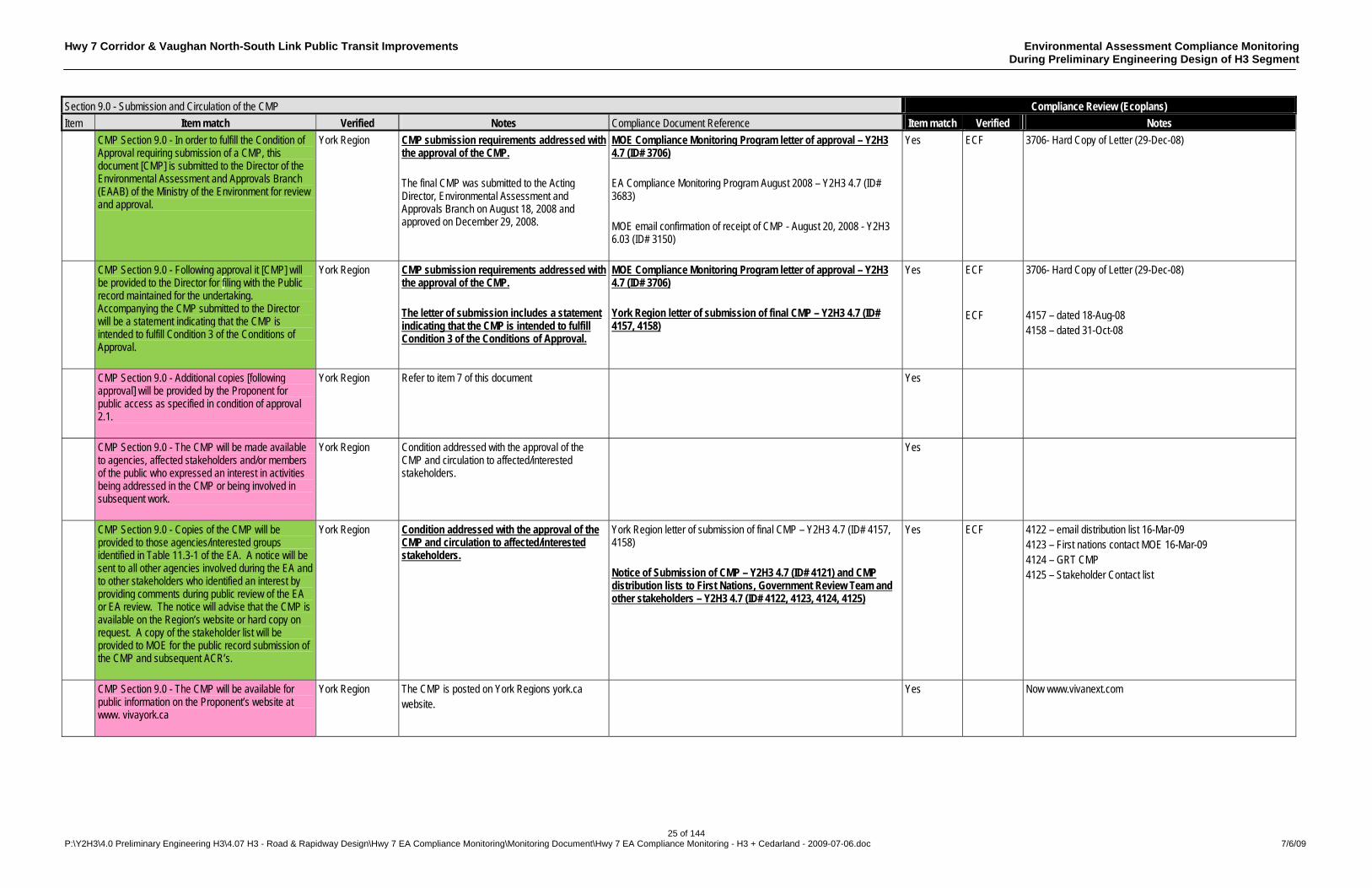
Section 9.0 - Submission and Circulation of the CMP Compliance Review (Ecoplans)
Item Item match Verified Notes Compliance Document Reference Item match Verified Notes
CMP Section 9.0 - In order to fulfill the Condition of Approval requiring submission of a CMP, this document [CMP] is submitted to the Director of the Environmental Assessment and Approvals Branch (EAAB) of the Ministry of the Environment for review and approval.
York Region CMP submission requirements addressed with the approval of the CMP. The final CMP was submitted to the Acting Director, Environmental Assessment and Approvals Branch on August 18, 2008 and approved on December 29, 2008.
MOE Compliance Monitoring Program letter of approval – Y2H3 4.7 (ID# 3706) EA Compliance Monitoring Program August 2008 – Y2H3 4.7 (ID# 3683) MOE email confirmation of receipt of CMP - August 20, 2008 - Y2H3 6.03 (ID# 3150)
Yes ECF 3706- Hard Copy of Letter (29-Dec-08)
CMP Section 9.0 - Following approval it [CMP] will be provided to the Director for filing with the Public record maintained for the undertaking. Accompanying the CMP submitted to the Director will be a statement indicating that the CMP is intended to fulfill Condition 3 of the Conditions of Approval.
York Region CMP submission requirements addressed with the approval of the CMP. The letter of submission includes a statement indicating that the CMP is intended to fulfill Condition 3 of the Conditions of Approval.
MOE Compliance Monitoring Program letter of approval – Y2H3 4.7 (ID# 3706) York Region letter of submission of final CMP – Y2H3 4.7 (ID# 4157, 4158)
Yes ECF ECF
3706- Hard Copy of Letter (29-Dec-08) 4157 – dated 18-Aug-08 4158 – dated 31-Oct-08
CMP Section 9.0 - Additional copies [following approval] will be provided by the Proponent for public access as specified in condition of approval 2.1.
York Region Refer to item 7 of this document
Yes
CMP Section 9.0 - The CMP will be made available to agencies, affected stakeholders and/or members of the public who expressed an interest in activities being addressed in the CMP or being involved in subsequent work.
York Region Condition addressed with the approval of the CMP and circulation to affected/interested stakeholders.
Yes
CMP Section 9.0 - Copies of the CMP will be provided to those agencies/interested groups identified in Table 11.3-1 of the EA. A notice will be sent to all other agencies involved during the EA and to other stakeholders who identified an interest by providing comments during public review of the EA or EA review. The notice will advise that the CMP is available on the Region’s website or hard copy on request. A copy of the stakeholder list will be provided to MOE for the public record submission of the CMP and subsequent ACR’s.
York Region Condition addressed with the approval of the CMP and circulation to affected/interested stakeholders.
York Region letter of submission of final CMP – Y2H3 4.7 (ID# 4157, 4158) Notice of Submission of CMP – Y2H3 4.7 (ID# 4121) and CMP distribution lists to First Nations, Government Review Team and other stakeholders – Y2H3 4.7 (ID# 4122, 4123, 4124, 4125)
Yes ECF 4122 – email distribution list 16-Mar-09 4123 – First nations contact MOE 16-Mar-09 4124 – GRT CMP 4125 – Stakeholder Contact list
CMP Section 9.0 - The CMP will be available for public information on the Proponent’s website at www. vivayork.ca
York Region The CMP is posted on York Regions york.ca website.
Yes Now www.vivanext.com
Hwy 7 Corridor & Vaughan North-South Link Public Transit Improvements Environmental Assessment Compliance Monitoring During Preliminary Engineering Design of H3 Segment
26 of 144 P:\Y2H3\4.0 Preliminary Engineering H3\4.07 H3 - Road & Rapidway Design\Hwy 7 EA Compliance Monitoring\Monitoring Document\Hwy 7 EA Compliance Monitoring - H3 + Cedarland - 2009-07-06.doc 7/6/09
Section 11.0 - Other Documents required by the Conditions of Approval
Compliance Monitoring Ecoplans
Item Mitigation Measure / Commitment to be Monitored Responsible person / agency
Status and Description of how commitment has been addressed during design
Compliance Document Reference Item match Verified Notes
Ridership Monitoring Program: CMP Section 11.1 - York Region will prepare the results of its Ridership Monitoring Program as committed in Section 5.2.2.3 of the EA and EAA Condition 4.1. The Ridership Monitoring Program will be provided to the City of Toronto, GO Transit, Ministry of Transportation, TTC, the Towns of Markham and Richmond Hill and the City of Vaughan for review.
York Region Relates to Section 5.2.2.3, Step 3, of the EA. The ridership monitoring period is 2007 – 2011 and the major review will not take place until 2012. In the mean time ridership monitoring is ongoing as evidenced by the referenced reports.
YRT\Viva 2007 Revenue Ridership Summary, YRT\Viva 2007 Ridership Summary - Specialized Services – Mobility Plus, Viva Monthly Operations Summary December 2007 Y1 8.02 (ID#’s 3106, 3107, 3108 )
3106 – 2007 Ridership Summary Specilized Services 3107 – 2007 Revenue Ridership Summary and monthly Ridership Summary 3108 – Viva Operations Monthly Summary
Technology Conversion Plan CMP Section 11.2 - A Technology Conversion Plan will be prepared to identify when and if conversion from a bus rapid transit (BRT) system to a Light Rail Transit (LRT) system will occur.
York Region A draft Transition Plan was prepared and submitted on March 02, 2007 and is presently under review as part of the ongoing Network Plan update. Transit network analysis is ongoing including LRT / subway technology conversion considerations. A 2009 Network Update Report is planned.
Transition Plan – Draft (March 2, 2007) – YC 2.4 (ID 910) Transmittal Memo YC 2.4 (ID 910)
Yes Yes ECF
CMP Section 11.2 - If conversion is found to be required prior to 2021, the Plan will include an implementation schedule.
York Region The draft Transition Plan included general indications of alternative schedules. The 2009 Network Update Report will address the overall sequence of implementation.
Transition Plan – Draft (March 2, 2007) – YC 2.4 (ID 910) Transmittal Memo YC 2.4 (ID 910)
Yes
CMP Section 11.2 - The Ridership Monitoring Program and Technology Conversion Plan will be placed on the public record file at the EAAB and the MOE’s Central Regional Office. A copy of these documents will also be provided to the City of Toronto, TTC, GO Transit, the Ministry of Transportation, the Towns of Markham and Richmond Hill and the City of Vaughan for review.
York Region As per above, the pending 2009 Network Update Report will address technology conversion. Ridership monitoring is ongoing as evidenced by the referenced reports.
YRT\Viva 2007 Revenue Ridership Summary, YRT\Viva 2007 Ridership Summary - Specialized Services – Mobility Plus, Viva Monthly Operations Summary December 2007 YC 8.02 (ID#’s 3106, 3107, 3108 )
Yes 3106 – 2007 Ridership Summary Specilized Services 3107 – 2007 Revenue Ridership Summary and monthly Ridership Summary 3108 – Viva Operations Monthly Summary
Complaints Protocol CMP Section 11.3 - Prior to construction, the Region will prepare a protocol on how it will deal with and respond to inquiries and complaints received during the construction and operation of the undertaking. The protocol will be submitted to the Central Region Director for placement on the Public Record.
York Region Protocol will be prepared during the Detail Design phase. Yes
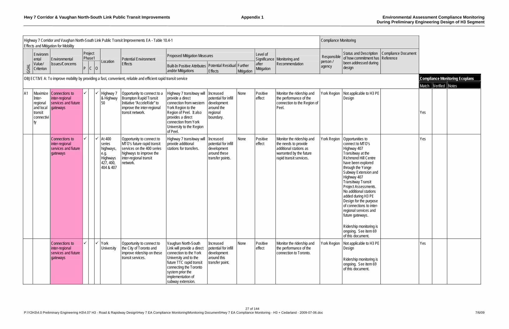
Hwy 7 Corridor & Vaughan North-South Link Public Transit Improvements Appendix 1 Environmental Assessment Compliance Monitoring During Preliminary Engineering Design of H3 Segment
27 of 144 P:\Y2H3\4.0 Preliminary Engineering H3\4.07 H3 - Road & Rapidway Design\Hwy 7 EA Compliance Monitoring\Monitoring Document\Hwy 7 EA Compliance Monitoring - H3 + Cedarland - 2009-07-06.doc 7/6/09
Highway 7 Corridor and Vaughan North-South Link Public Transit Improvements EA - Table 10.4-1 Effects and Mitigation for Mobility
Compliance Monitoring
Project Phase1
Proposed Mitigation Measures
GO
AL
Environmental Value/ Criterion
Environmental Issues/Concerns
P C O
Location Potential Environment Effects Built-In Positive Attributes
and/or Mitigations Potential Residual Effects
Further Mitigation
Level of Significance after Mitigation
Monitoring and Recommendation
Responsible person / agency
Status and Description of how commitment has been addressed during design
Compliance Document Reference
Compliance Monitoring Ecoplans OBJECTIVE A: To improve mobility by providing a fast, convenient, reliable and efficient rapid transit service
Match Verified Notes
A1 Maximize Inter-regional and local transit connectivity
Connections to inter-regional services and future gateways
Highway 7 & Highway 50
Opportunity to connect to a Brampton Rapid Transit Initiative “AcceleRide” to improve the inter-regional transit network.
Highway 7 transitway will provide a direct connection from western York Region to the Region of Peel. It also provides a direct connection from York University to the Region of Peel.
Increased potential for infill development around the regional boundary.
None Positive effect
Monitor the ridership and the performance of the connection to the Region of Peel.
York Region Not applicable to H3 PE Design
Yes
Connections to inter-regional services and future gateways
At 400 series highways, e.g. Highways 427, 400, 404 & 407
Opportunity to connect to MTO’s future rapid transit services on the 400 series highways to improve the inter-regional transit network.
Highway 7 transitway will provide additional stations for transfers.
Increased potential for infill development around these transfer points.
None Positive effect
Monitor the ridership and the needs to provide additional stations as warranted by the future rapid transit services.
York Region Opportunities to connect to MTO’s Highway 407 Transitway at the Richmond Hill Centre have been explored through the Yonge Subway Extension and Highway 407 Transitway Transit Project Assessments. No additional stations added during H3 PE Design for the purpose of connections to inter-regional services and future gateways. Ridership monitoring is ongoing. See item 69 of this document.
Yes
Connections to inter-regional services and future gateways
York University
Opportunity to connect to the City of Toronto and improve ridership on these transit services.
Vaughan North-South Link will provide a direct connection to the York University and to the future TTC rapid transit connecting the Toronto system prior the implementation of subway extension.
Increased potential for infill development around this transfer point.
None Positive effect
Monitor the ridership and the performance of the connection to Toronto.
York Region Not applicable to H3 PE Design Ridership monitoring is ongoing. See item 69 of this document.
Yes

Hwy 7 Corridor & Vaughan North-South Link Public Transit Improvements Appendix 1 Environmental Assessment Compliance Monitoring During Preliminary Engineering Design of H3 Segment
28 of 144 P:\Y2H3\4.0 Preliminary Engineering H3\4.07 H3 - Road & Rapidway Design\Hwy 7 EA Compliance Monitoring\Monitoring Document\Hwy 7 EA Compliance Monitoring - H3 + Cedarland - 2009-07-06.doc 7/6/09
Highway 7 Corridor and Vaughan North-South Link Public Transit Improvements EA - Table 10.4-1 Effects and Mitigation for Mobility
Compliance Monitoring
Project Phase1
Proposed Mitigation Measures
GO
AL
Environmental Value/ Criterion
Environmental Issues/Concerns
P C O
Location Potential Environment Effects Built-In Positive Attributes
and/or Mitigations Potential Residual Effects
Further Mitigation
Level of Significance after Mitigation
Monitoring and Recommendation
Responsible person / agency
Status and Description of how commitment has been addressed during design
Compliance Document Reference
Compliance Monitoring Ecoplans OBJECTIVE A: To improve mobility by providing a fast, convenient, reliable and efficient rapid transit service
Match Verified Notes
Connections to inter-regional services and future gateways
Proposed Richmond Hill Centre Intermodal Station
Better connection to GO Stations and future provincial inter-regional 407 Transitway station will improve ridership on all transit services
Highway 7 transitway will provide a direct connection to GO Rail’s Richmond Hill Line at the proposed Richmond Hill Centre Intermodal Station. It will also have a connection to York’s Yonge Street transitway and the future provincial transit corridor along Highway 407.
Increased potential for infill development around Richmond Hill Centre Intermodal Station
None Positive effect
Monitor ridership and the performance of the connection to GO Langstaff Station
York Region Pedestrian bridge between the Viva Richmond Hill Terminal and the Bala Go Rail Platform was constructed and opened for use April 2008, improving GO connection performance. Opportunities to connect to MTO’s Highway 407 Transitway at the Richmond Hill Centre have been explored through the Yonge Subway Extension and Highway 407 Transitway Transit Project Assessments. Ridership monitoring is ongoing. See item 69 of this document.
Pedestrian Bridge Drawings 100 % Submission – YC file path: P:\YC2002\QS Detail Design\Langstaff Pedestrian Bridge\Transmittal
Yes
Connections to inter-regional services and future gateways
Unionville GO Station
Connection to Unionville GO Station will improve York’s transit network.
A pedestrian walkway will be provided to transfer the transitway passengers to the Unionville GO Station. This will provide a fast and reliable service from the future Markham Centre to the City of Toronto or northern York Region via the GO Rail’s Stouffville Line.
Increased potential for infill development around this transfer point.
None Positive effect
Monitor the ridership and the performance of the connection to Unionville GO Station.
York Region PE Design of the connection to Unionville GO Station has not yet commenced. Ridership monitoring is ongoing. See item 69 of this document.
Yes
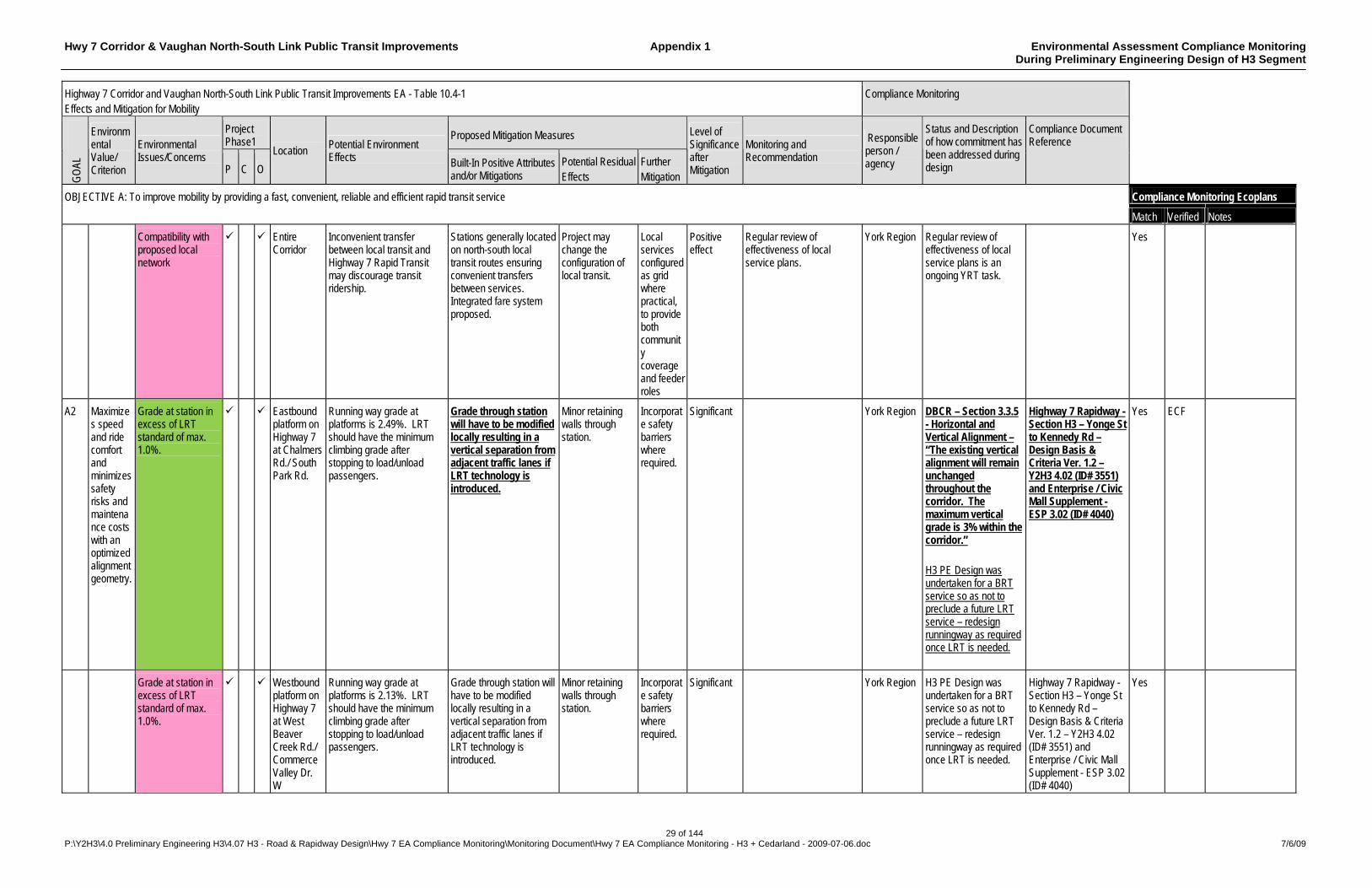
Hwy 7 Corridor & Vaughan North-South Link Public Transit Improvements Appendix 1 Environmental Assessment Compliance Monitoring During Preliminary Engineering Design of H3 Segment
29 of 144 P:\Y2H3\4.0 Preliminary Engineering H3\4.07 H3 - Road & Rapidway Design\Hwy 7 EA Compliance Monitoring\Monitoring Document\Hwy 7 EA Compliance Monitoring - H3 + Cedarland - 2009-07-06.doc 7/6/09
Highway 7 Corridor and Vaughan North-South Link Public Transit Improvements EA - Table 10.4-1 Effects and Mitigation for Mobility
Compliance Monitoring
Project Phase1
Proposed Mitigation Measures
GO
AL
Environmental Value/ Criterion
Environmental Issues/Concerns
P C O
Location Potential Environment Effects Built-In Positive Attributes
and/or Mitigations Potential Residual Effects
Further Mitigation
Level of Significance after Mitigation
Monitoring and Recommendation
Responsible person / agency
Status and Description of how commitment has been addressed during design
Compliance Document Reference
Compliance Monitoring Ecoplans OBJECTIVE A: To improve mobility by providing a fast, convenient, reliable and efficient rapid transit service
Match Verified Notes
Compatibility with proposed local network
Entire Corridor
Inconvenient transfer between local transit and Highway 7 Rapid Transit may discourage transit ridership.
Stations generally located on north-south local transit routes ensuring convenient transfers between services. Integrated fare system proposed.
Project may change the configuration of local transit.
Local services configured as grid where practical, to provide both community coverage and feeder roles
Positive effect
Regular review of effectiveness of local service plans.
York Region Regular review of effectiveness of local service plans is an ongoing YRT task.
Yes
A2 Maximizes speed and ride comfort and minimizes safety risks and maintenance costs with an optimized alignment geometry.
Grade at station in excess of LRT standard of max. 1.0%.
Eastbound platform on Highway 7 at Chalmers Rd./ South Park Rd.
Running way grade at platforms is 2.49%. LRT should have the minimum climbing grade after stopping to load/unload passengers.
Grade through station will have to be modified locally resulting in a vertical separation from adjacent traffic lanes if LRT technology is introduced.
Minor retaining walls through station.
Incorporate safety barriers where required.
Significant York Region DBCR – Section 3.3.5 - Horizontal and Vertical Alignment – “The existing vertical alignment will remain unchanged throughout the corridor. The maximum vertical grade is 3% within the corridor.” H3 PE Design was undertaken for a BRT service so as not to preclude a future LRT service – redesign runningway as required once LRT is needed.
Highway 7 Rapidway - Section H3 – Yonge St to Kennedy Rd – Design Basis & Criteria Ver. 1.2 – Y2H3 4.02 (ID# 3551) and Enterprise / Civic Mall Supplement - ESP 3.02 (ID# 4040)
Yes ECF
Grade at station in excess of LRT standard of max. 1.0%.
Westbound platform on Highway 7 at West Beaver Creek Rd./ Commerce Valley Dr. W
Running way grade at platforms is 2.13%. LRT should have the minimum climbing grade after stopping to load/unload passengers.
Grade through station will have to be modified locally resulting in a vertical separation from adjacent traffic lanes if LRT technology is introduced.
Minor retaining walls through station.
Incorporate safety barriers where required.
Significant York Region H3 PE Design was undertaken for a BRT service so as not to preclude a future LRT service – redesign runningway as required once LRT is needed.
Highway 7 Rapidway - Section H3 – Yonge St to Kennedy Rd – Design Basis & Criteria Ver. 1.2 – Y2H3 4.02 (ID# 3551) and Enterprise / Civic Mall Supplement - ESP 3.02 (ID# 4040)
Yes
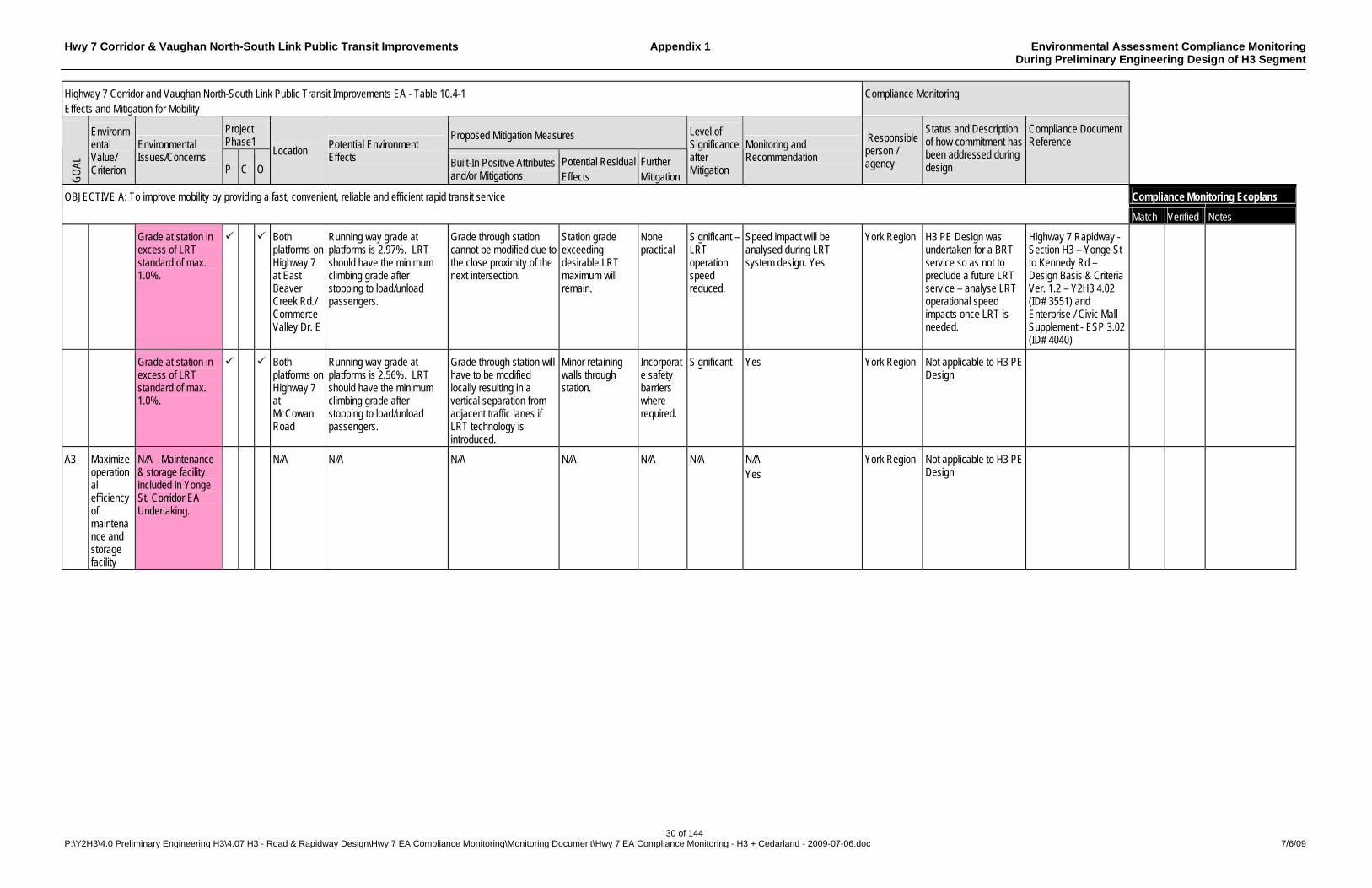
Hwy 7 Corridor & Vaughan North-South Link Public Transit Improvements Appendix 1 Environmental Assessment Compliance Monitoring During Preliminary Engineering Design of H3 Segment
30 of 144 P:\Y2H3\4.0 Preliminary Engineering H3\4.07 H3 - Road & Rapidway Design\Hwy 7 EA Compliance Monitoring\Monitoring Document\Hwy 7 EA Compliance Monitoring - H3 + Cedarland - 2009-07-06.doc 7/6/09
Highway 7 Corridor and Vaughan North-South Link Public Transit Improvements EA - Table 10.4-1 Effects and Mitigation for Mobility
Compliance Monitoring
Project Phase1
Proposed Mitigation Measures
GO
AL
Environmental Value/ Criterion
Environmental Issues/Concerns
P C O
Location Potential Environment Effects Built-In Positive Attributes
and/or Mitigations Potential Residual Effects
Further Mitigation
Level of Significance after Mitigation
Monitoring and Recommendation
Responsible person / agency
Status and Description of how commitment has been addressed during design
Compliance Document Reference
Compliance Monitoring Ecoplans OBJECTIVE A: To improve mobility by providing a fast, convenient, reliable and efficient rapid transit service
Match Verified Notes
Grade at station in excess of LRT standard of max. 1.0%.
Both platforms on Highway 7 at East Beaver Creek Rd./ Commerce Valley Dr. E
Running way grade at platforms is 2.97%. LRT should have the minimum climbing grade after stopping to load/unload passengers.
Grade through station cannot be modified due to the close proximity of the next intersection.
Station grade exceeding desirable LRT maximum will remain.
None practical
Significant – LRT operation speed reduced.
Speed impact will be analysed during LRT system design. Yes
York Region H3 PE Design was undertaken for a BRT service so as not to preclude a future LRT service – analyse LRT operational speed impacts once LRT is needed.
Highway 7 Rapidway - Section H3 – Yonge St to Kennedy Rd – Design Basis & Criteria Ver. 1.2 – Y2H3 4.02 (ID# 3551) and Enterprise / Civic Mall Supplement - ESP 3.02 (ID# 4040)
Grade at station in excess of LRT standard of max. 1.0%.
Both platforms on Highway 7 at McCowan Road
Running way grade at platforms is 2.56%. LRT should have the minimum climbing grade after stopping to load/unload passengers.
Grade through station will have to be modified locally resulting in a vertical separation from adjacent traffic lanes if LRT technology is introduced.
Minor retaining walls through station.
Incorporate safety barriers where required.
Significant Yes York Region Not applicable to H3 PE Design
A3 Maximize operational efficiency of maintenance and storage facility
N/A - Maintenance & storage facility included in Yonge St. Corridor EA Undertaking.
N/A
N/A
N/A
N/A
N/A
N/A
N/A Yes
York Region Not applicable to H3 PE Design

Hwy 7 Corridor & Vaughan North-South Link Public Transit Improvements Appendix 1 Environmental Assessment Compliance Monitoring During Preliminary Engineering Design of H3 Segment
31 of 144 P:\Y2H3\4.0 Preliminary Engineering H3\4.07 H3 - Road & Rapidway Design\Hwy 7 EA Compliance Monitoring\Monitoring Document\Hwy 7 EA Compliance Monitoring - H3 + Cedarland - 2009-07-06.doc 7/6/09
Highway 7 Corridor and Vaughan North-South Link Public Transit Improvements EA - Table 10.4-1 Effects and Mitigation for Mobility
Compliance Monitoring
Project Phase1
Proposed Mitigation Measures
GO
AL
Environmental Value/ Criterion
Environmental Issues/Concerns
P C O
Location Potential Environment Effects Built-In Positive Attributes
and/or Mitigations Potential Residual Effects
Further Mitigation
Level of Significance after Mitigation
Monitoring and Recommendation
Responsible person / agency
Status and Description of how commitment has been addressed during design
Compliance Document Reference
Compliance Monitoring Ecoplans OBJECTIVE A: To improve mobility by providing a fast, convenient, reliable and efficient rapid transit service
Match Verified Notes
A4 Increase attractiveness of rapid transit service
Travel time and service reliability
Entire Corridor
Adjustments to signal timing to achieve progression and minimize delay to rapid transit.
Micro-simulation of rapid transit operation and general traffic movements during detailed design will be used to optimize signal timing. Transit speed will be increased to maximum achievable with reasonable intersection operation.
Delay to transit or intersecting traffic may be unacceptable. May affect intersection capacity for general traffic movements.
Modification of inter-section signal timing.
Moderately significant
Pursue an on-going intersection performance monitoring program
York Region Section 3.1.4 of the DBCR - A VISSIM micro-simulation traffic model was used to simulate traffic flows not only at the traffic signal junctions but also through the links of the traffic system. The model was used to assess the impacts of traffic conditions on transit vehicles as they progressed through the Rapidway Section 1.4.1 of the DBCR - Signal controlled transit priority at all major intersections
Highway 7 Rapidway - Section H3 – Yonge St to Kennedy Rd – Design Basis & Criteria Ver. 1.2 – Y2H3 4.02 (ID# 3551) and Enterprise / Civic Mall Supplement - ESP 3.02 (ID# 4040)
yes ECF Found in Appendix A (under separate cover) TASK 4.12: TRAFFIC IMPACT ANALYSIS (H3) HIGHWAY 7 - YONGE STREET CONNECTOR RAMP TO SOUTH TOWN CENTRE BOULEVARD (Sept 2008)
A5 Locate stations to maximize ridership potential and convenience of access for all users
Residents/Employees within walking distance of station locations. Accessibility of stations/transit system.
Entire Corridor
Stations at locations with automobile-oriented land use could discourage rapid transit use.
Station locations selected to serve supportive land use. Facilities designed with weather protection, direct barrier-free access and attractive streetscapes within surrounding residential neighbourhoods.
Continued dependence on automobile if land use objectives not achieved
Greater emphasis on supportive land use
Positive effect
Regular review of land use and new or infill development potential during detailed design phases for transitway and stations.
York Region York Region has developed guidelines for assessing potential locations for new viva stations.
Memo - Station Location Optimization Y1 8.01 (ID # 640). Other supporting documents Y1 8.01 (ID # 639 & 689)
Yes NSE Evidence does not support that guide lines have been developed. 640 – Briefing and email no memo 639 – Email 689 – drafts of presentation and emails
Notes: P – Pre construction, C – Construction, O – Operation
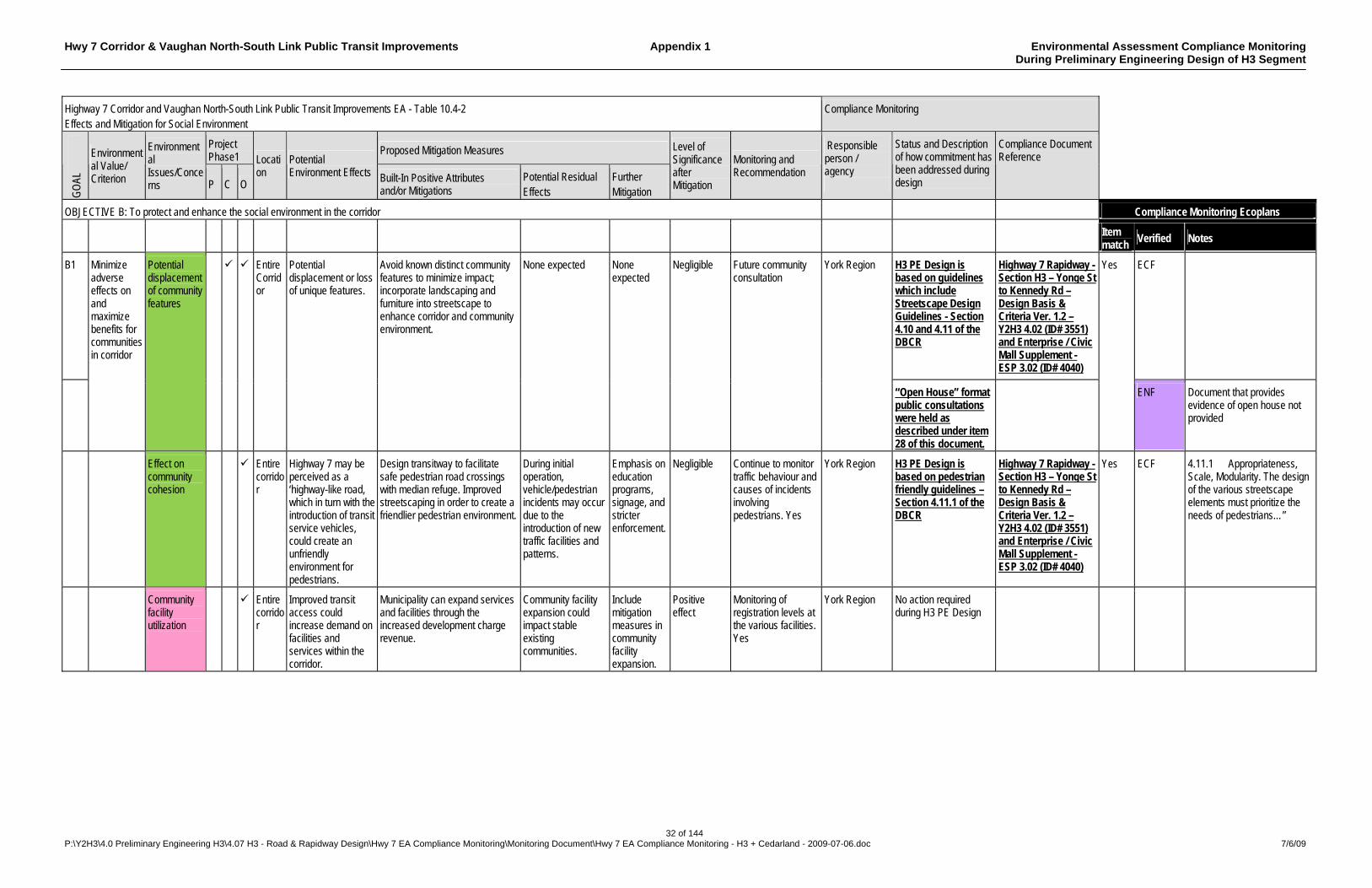
Hwy 7 Corridor & Vaughan North-South Link Public Transit Improvements Appendix 1 Environmental Assessment Compliance Monitoring During Preliminary Engineering Design of H3 Segment
32 of 144 P:\Y2H3\4.0 Preliminary Engineering H3\4.07 H3 - Road & Rapidway Design\Hwy 7 EA Compliance Monitoring\Monitoring Document\Hwy 7 EA Compliance Monitoring - H3 + Cedarland - 2009-07-06.doc 7/6/09
Highway 7 Corridor and Vaughan North-South Link Public Transit Improvements EA - Table 10.4-2 Effects and Mitigation for Social Environment
Compliance Monitoring
Project Phase1
Proposed Mitigation Measures
GO
AL
Environmental Value/ Criterion
Environmental Issues/Concerns P C O
Location
Potential Environment Effects Built-In Positive Attributes
and/or Mitigations Potential Residual Effects
Further Mitigation
Level of Significance after Mitigation
Monitoring and Recommendation
Responsible person / agency
Status and Description of how commitment has been addressed during design
Compliance Document Reference
OBJECTIVE B: To protect and enhance the social environment in the corridor Compliance Monitoring Ecoplans
Item match
Verified Notes
B1 H3 PE Design is based on guidelines which include Streetscape Design Guidelines - Section 4.10 and 4.11 of the DBCR
Highway 7 Rapidway - Section H3 – Yonge St to Kennedy Rd – Design Basis & Criteria Ver. 1.2 – Y2H3 4.02 (ID# 3551) and Enterprise / Civic Mall Supplement - ESP 3.02 (ID# 4040)
ECF
Minimize adverse effects on and maximize benefits for communities in corridor
Potential displacement of community features
Entire Corridor
Potential displacement or loss of unique features.
Avoid known distinct community features to minimize impact; incorporate landscaping and furniture into streetscape to enhance corridor and community environment.
None expected None expected
Negligible Future community consultation
York Region
“Open House” format public consultations were held as described under item 28 of this document.
Yes
ENF Document that provides evidence of open house not provided
Effect on community cohesion
Entire corridor
Highway 7 may be perceived as a ‘highway-like road, which in turn with the introduction of transit service vehicles, could create an unfriendly environment for pedestrians.
Design transitway to facilitate safe pedestrian road crossings with median refuge. Improved streetscaping in order to create a friendlier pedestrian environment.
During initial operation, vehicle/pedestrian incidents may occur due to the introduction of new traffic facilities and patterns.
Emphasis on education programs, signage, and stricter enforcement.
Negligible Continue to monitor traffic behaviour and causes of incidents involving pedestrians. Yes
York Region H3 PE Design is based on pedestrian friendly guidelines – Section 4.11.1 of the DBCR
Highway 7 Rapidway - Section H3 – Yonge St to Kennedy Rd – Design Basis & Criteria Ver. 1.2 – Y2H3 4.02 (ID# 3551) and Enterprise / Civic Mall Supplement - ESP 3.02 (ID# 4040)
Yes ECF 4.11.1 Appropriateness, Scale, Modularity. The design of the various streetscape elements must prioritize the needs of pedestrians…”
Community facility utilization
Entire corridor
Improved transit access could increase demand on facilities and services within the corridor.
Municipality can expand services and facilities through the increased development charge revenue.
Community facility expansion could impact stable existing communities.
Include mitigation measures in community facility expansion.
Positive effect
Monitoring of registration levels at the various facilities. Yes
York Region No action required during H3 PE Design
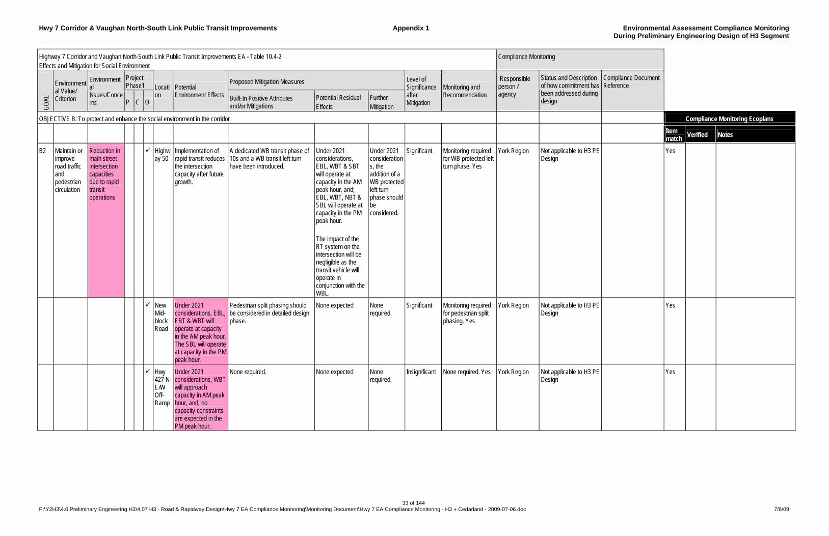
Hwy 7 Corridor & Vaughan North-South Link Public Transit Improvements Appendix 1 Environmental Assessment Compliance Monitoring During Preliminary Engineering Design of H3 Segment
33 of 144 P:\Y2H3\4.0 Preliminary Engineering H3\4.07 H3 - Road & Rapidway Design\Hwy 7 EA Compliance Monitoring\Monitoring Document\Hwy 7 EA Compliance Monitoring - H3 + Cedarland - 2009-07-06.doc 7/6/09
Highway 7 Corridor and Vaughan North-South Link Public Transit Improvements EA - Table 10.4-2 Effects and Mitigation for Social Environment
Compliance Monitoring
Project Phase1
Proposed Mitigation Measures
GO
AL
Environmental Value/ Criterion
Environmental Issues/Concerns P C O
Location
Potential Environment Effects Built-In Positive Attributes
and/or Mitigations Potential Residual Effects
Further Mitigation
Level of Significance after Mitigation
Monitoring and Recommendation
Responsible person / agency
Status and Description of how commitment has been addressed during design
Compliance Document Reference
OBJECTIVE B: To protect and enhance the social environment in the corridor Compliance Monitoring Ecoplans
Item match
Verified Notes
B2
Maintain or improve road traffic and pedestrian circulation
Reduction in main street intersection capacities due to rapid transit operations
Highway 50
Implementation of rapid transit reduces the intersection capacity after future growth.
A dedicated WB transit phase of 10s and a WB transit left turn have been introduced.
Under 2021 considerations, EBL, WBT & SBT will operate at capacity in the AM peak hour, and; EBL, WBT, NBT & SBL will operate at capacity in the PM peak hour. The impact of the RT system on the intersection will be negligible as the transit vehicle will operate in conjunction with the WBL.
Under 2021 considerations, the addition of a WB protected left turn phase should be considered.
Significant Monitoring required for WB protected left turn phase. Yes
York Region Not applicable to H3 PE Design
Yes
New Mid-block Road
Under 2021 considerations, EBL, EBT & WBT will operate at capacity in the AM peak hour. The SBL will operate at capacity in the PM peak hour.
Pedestrian split phasing should be considered in detailed design phase.
None expected None required.
Significant Monitoring required for pedestrian split phasing. Yes
York Region Not applicable to H3 PE Design
Yes
Hwy 427 N-E/W Off-Ramp
Under 2021 considerations, WBT will approach capacity in AM peak hour, and; no capacity constraints are expected in the PM peak hour.
None required. None expected None required.
Insignificant None required. Yes York Region Not applicable to H3 PE Design
Yes
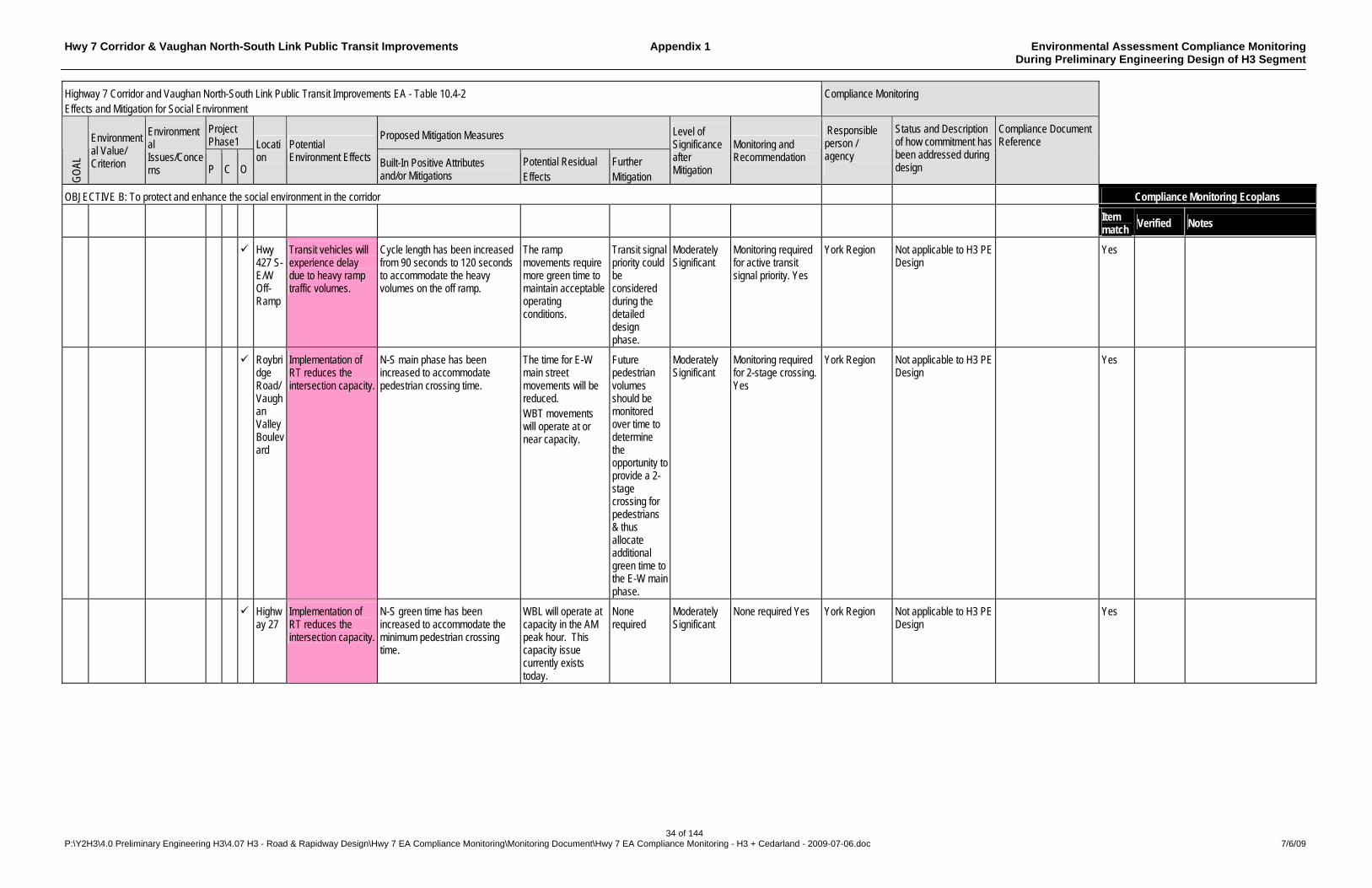
Hwy 7 Corridor & Vaughan North-South Link Public Transit Improvements Appendix 1 Environmental Assessment Compliance Monitoring During Preliminary Engineering Design of H3 Segment
34 of 144 P:\Y2H3\4.0 Preliminary Engineering H3\4.07 H3 - Road & Rapidway Design\Hwy 7 EA Compliance Monitoring\Monitoring Document\Hwy 7 EA Compliance Monitoring - H3 + Cedarland - 2009-07-06.doc 7/6/09
Highway 7 Corridor and Vaughan North-South Link Public Transit Improvements EA - Table 10.4-2 Effects and Mitigation for Social Environment
Compliance Monitoring
Project Phase1
Proposed Mitigation Measures
GO
AL
Environmental Value/ Criterion
Environmental Issues/Concerns P C O
Location
Potential Environment Effects Built-In Positive Attributes
and/or Mitigations Potential Residual Effects
Further Mitigation
Level of Significance after Mitigation
Monitoring and Recommendation
Responsible person / agency
Status and Description of how commitment has been addressed during design
Compliance Document Reference
OBJECTIVE B: To protect and enhance the social environment in the corridor Compliance Monitoring Ecoplans
Item match
Verified Notes
Hwy 427 S-E/W Off-Ramp
Transit vehicles will experience delay due to heavy ramp traffic volumes.
Cycle length has been increased from 90 seconds to 120 seconds to accommodate the heavy volumes on the off ramp.
The ramp movements require more green time to maintain acceptable operating conditions.
Transit signal priority could be considered during the detailed design phase.
Moderately Significant
Monitoring required for active transit signal priority. Yes
York Region Not applicable to H3 PE Design
Yes
Roybridge Road/ Vaughan Valley Boulevard
Implementation of RT reduces the intersection capacity.
N-S main phase has been increased to accommodate pedestrian crossing time.
The time for E-W main street movements will be reduced. WBT movements will operate at or near capacity.
Future pedestrian volumes should be monitored over time to determine the opportunity to provide a 2-stage crossing for pedestrians & thus allocate additional green time to the E-W main phase.
Moderately Significant
Monitoring required for 2-stage crossing. Yes
York Region Not applicable to H3 PE Design
Yes
Highway 27
Implementation of RT reduces the intersection capacity.
N-S green time has been increased to accommodate the minimum pedestrian crossing time.
WBL will operate at capacity in the AM peak hour. This capacity issue currently exists today.
None required
Moderately Significant
None required Yes York Region Not applicable to H3 PE Design
Yes
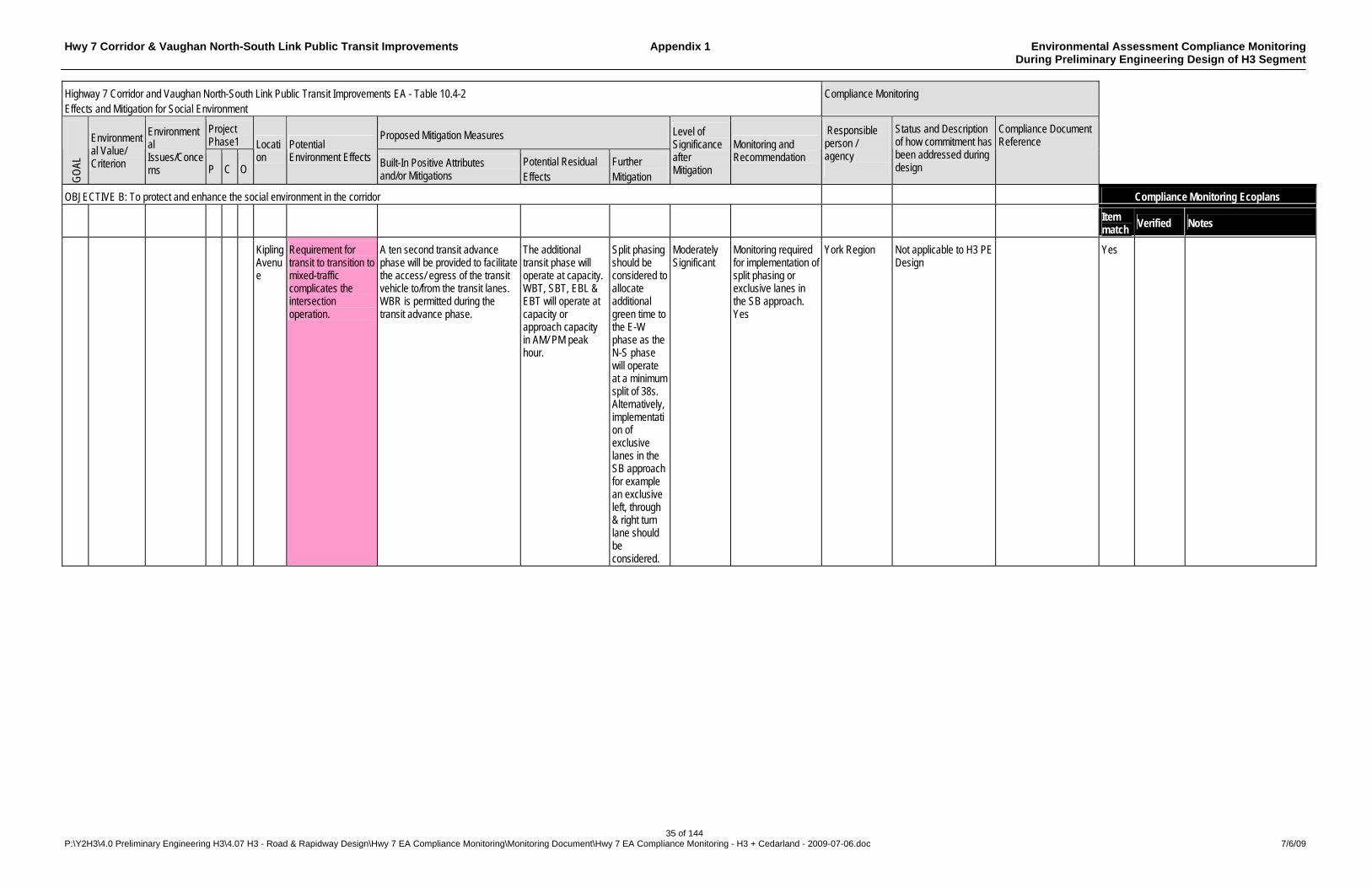
Hwy 7 Corridor & Vaughan North-South Link Public Transit Improvements Appendix 1 Environmental Assessment Compliance Monitoring During Preliminary Engineering Design of H3 Segment
35 of 144 P:\Y2H3\4.0 Preliminary Engineering H3\4.07 H3 - Road & Rapidway Design\Hwy 7 EA Compliance Monitoring\Monitoring Document\Hwy 7 EA Compliance Monitoring - H3 + Cedarland - 2009-07-06.doc 7/6/09
Highway 7 Corridor and Vaughan North-South Link Public Transit Improvements EA - Table 10.4-2 Effects and Mitigation for Social Environment
Compliance Monitoring
Project Phase1
Proposed Mitigation Measures
GO
AL
Environmental Value/ Criterion
Environmental Issues/Concerns P C O
Location
Potential Environment Effects Built-In Positive Attributes
and/or Mitigations Potential Residual Effects
Further Mitigation
Level of Significance after Mitigation
Monitoring and Recommendation
Responsible person / agency
Status and Description of how commitment has been addressed during design
Compliance Document Reference
OBJECTIVE B: To protect and enhance the social environment in the corridor Compliance Monitoring Ecoplans
Item match
Verified Notes
Kipling Avenue
Requirement for transit to transition to mixed-traffic complicates the intersection operation.
A ten second transit advance phase will be provided to facilitate the access/ egress of the transit vehicle to/from the transit lanes. WBR is permitted during the transit advance phase.
The additional transit phase will operate at capacity. WBT, SBT, EBL & EBT will operate at capacity or approach capacity in AM/ PM peak hour.
Split phasing should be considered to allocate additional green time to the E-W phase as the N-S phase will operate at a minimum split of 38s. Alternatively, implementation of exclusive lanes in the SB approach for example an exclusive left, through & right turn lane should be considered.
Moderately Significant
Monitoring required for implementation of split phasing or exclusive lanes in the SB approach. Yes
York Region Not applicable to H3 PE Design
Yes
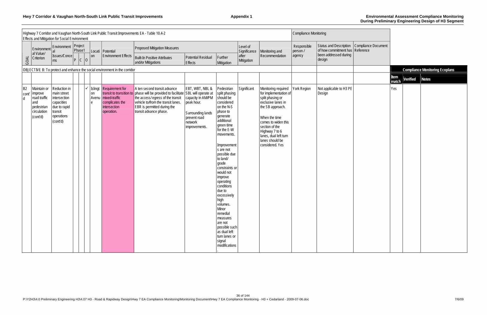
Hwy 7 Corridor & Vaughan North-South Link Public Transit Improvements Appendix 1 Environmental Assessment Compliance Monitoring During Preliminary Engineering Design of H3 Segment
36 of 144 P:\Y2H3\4.0 Preliminary Engineering H3\4.07 H3 - Road & Rapidway Design\Hwy 7 EA Compliance Monitoring\Monitoring Document\Hwy 7 EA Compliance Monitoring - H3 + Cedarland - 2009-07-06.doc 7/6/09
Highway 7 Corridor and Vaughan North-South Link Public Transit Improvements EA - Table 10.4-2 Effects and Mitigation for Social Environment
Compliance Monitoring
Project Phase1
Proposed Mitigation Measures
GO
AL
Environmental Value/ Criterion
Environmental Issues/Concerns P C O
Location
Potential Environment Effects Built-In Positive Attributes
and/or Mitigations Potential Residual Effects
Further Mitigation
Level of Significance after Mitigation
Monitoring and Recommendation
Responsible person / agency
Status and Description of how commitment has been addressed during design
Compliance Document Reference
OBJECTIVE B: To protect and enhance the social environment in the corridor Compliance Monitoring Ecoplans
Item match
Verified Notes
B2 cont’d
Maintain or improve road traffic and pedestrian circulation (cont’d)
Reduction in main street intersection capacities due to rapid transit operations (cont’d)
Islington Avenue
Requirement for transit to transition to mixed-traffic complicates the intersection operation.
A ten second transit advance phase will be provided to facilitate the access/ egress of the transit vehicle to/from the transit lanes. EBR is permitted during the transit advance phase.
EBT, WBT, NBL & SBL will operate at capacity in AM/PM peak hour. Surrounding lands prevent road network improvements.
Pedestrian split phasing should be considered on the N-S phase to generate additional green time for the E-W movements. Improvements are not possible due to land/ grade constraints or would not improve operating conditions due to excessively high volumes. Minor remedial measures are not possible such as dual left turn lanes or signal modifications.
Significant Monitoring required for implementation of split phasing or exclusive lanes in the SB approach. When the time comes to widen this section of the Highway 7 to 6 lanes, dual left turn lanes should be considered. Yes
York Region Not applicable to H3 PE Design
Yes
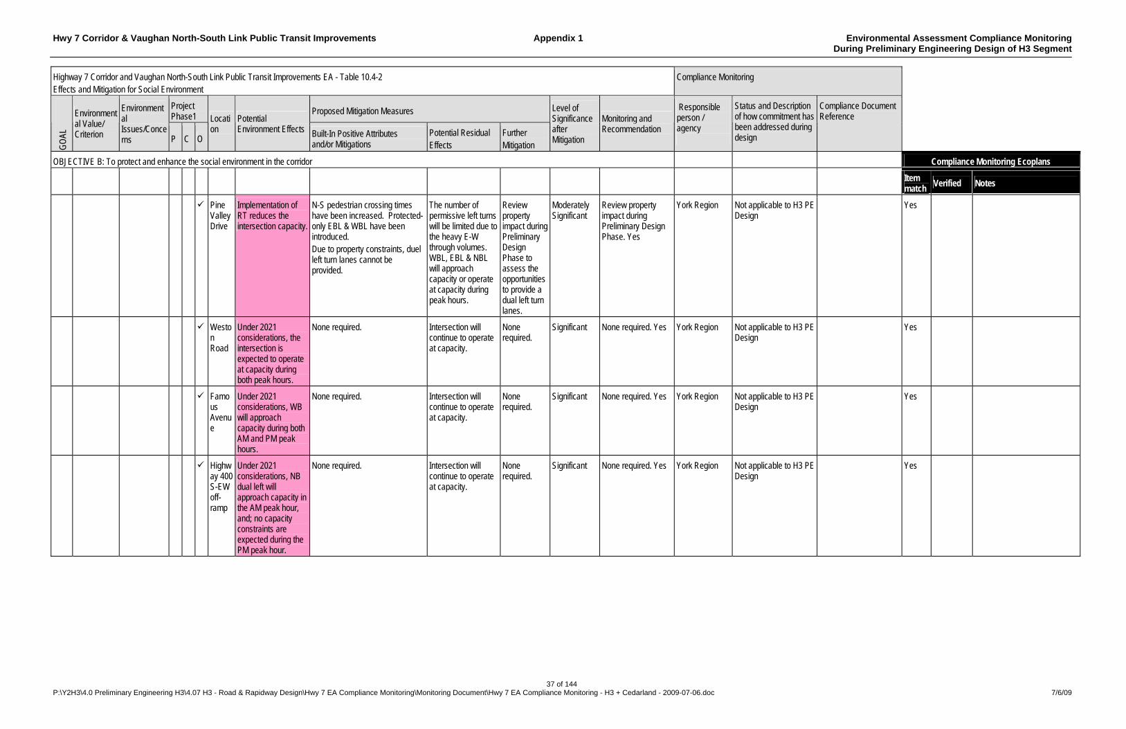
Hwy 7 Corridor & Vaughan North-South Link Public Transit Improvements Appendix 1 Environmental Assessment Compliance Monitoring During Preliminary Engineering Design of H3 Segment
37 of 144 P:\Y2H3\4.0 Preliminary Engineering H3\4.07 H3 - Road & Rapidway Design\Hwy 7 EA Compliance Monitoring\Monitoring Document\Hwy 7 EA Compliance Monitoring - H3 + Cedarland - 2009-07-06.doc 7/6/09
Highway 7 Corridor and Vaughan North-South Link Public Transit Improvements EA - Table 10.4-2 Effects and Mitigation for Social Environment
Compliance Monitoring
Project Phase1
Proposed Mitigation Measures
GO
AL
Environmental Value/ Criterion
Environmental Issues/Concerns P C O
Location
Potential Environment Effects Built-In Positive Attributes
and/or Mitigations Potential Residual Effects
Further Mitigation
Level of Significance after Mitigation
Monitoring and Recommendation
Responsible person / agency
Status and Description of how commitment has been addressed during design
Compliance Document Reference
OBJECTIVE B: To protect and enhance the social environment in the corridor Compliance Monitoring Ecoplans
Item match
Verified Notes
Pine Valley Drive
Implementation of RT reduces the intersection capacity.
N-S pedestrian crossing times have been increased. Protected-only EBL & WBL have been introduced. Due to property constraints, duel left turn lanes cannot be provided.
The number of permissive left turns will be limited due to the heavy E-W through volumes. WBL, EBL & NBL will approach capacity or operate at capacity during peak hours.
Review property impact during Preliminary Design Phase to assess the opportunities to provide a dual left turn lanes.
Moderately Significant
Review property impact during Preliminary Design Phase. Yes
York Region Not applicable to H3 PE Design
Yes
Weston Road
Under 2021 considerations, the intersection is expected to operate at capacity during both peak hours.
None required. Intersection will continue to operate at capacity.
None required.
Significant None required. Yes York Region Not applicable to H3 PE Design
Yes
Famous Avenue
Under 2021 considerations, WB will approach capacity during both AM and PM peak hours.
None required. Intersection will continue to operate at capacity.
None required.
Significant None required. Yes York Region Not applicable to H3 PE Design
Yes
Highway 400 S-EW off-ramp
Under 2021 considerations, NB dual left will approach capacity in the AM peak hour, and; no capacity constraints are expected during the PM peak hour.
None required. Intersection will continue to operate at capacity.
None required.
Significant None required. Yes York Region Not applicable to H3 PE Design
Yes
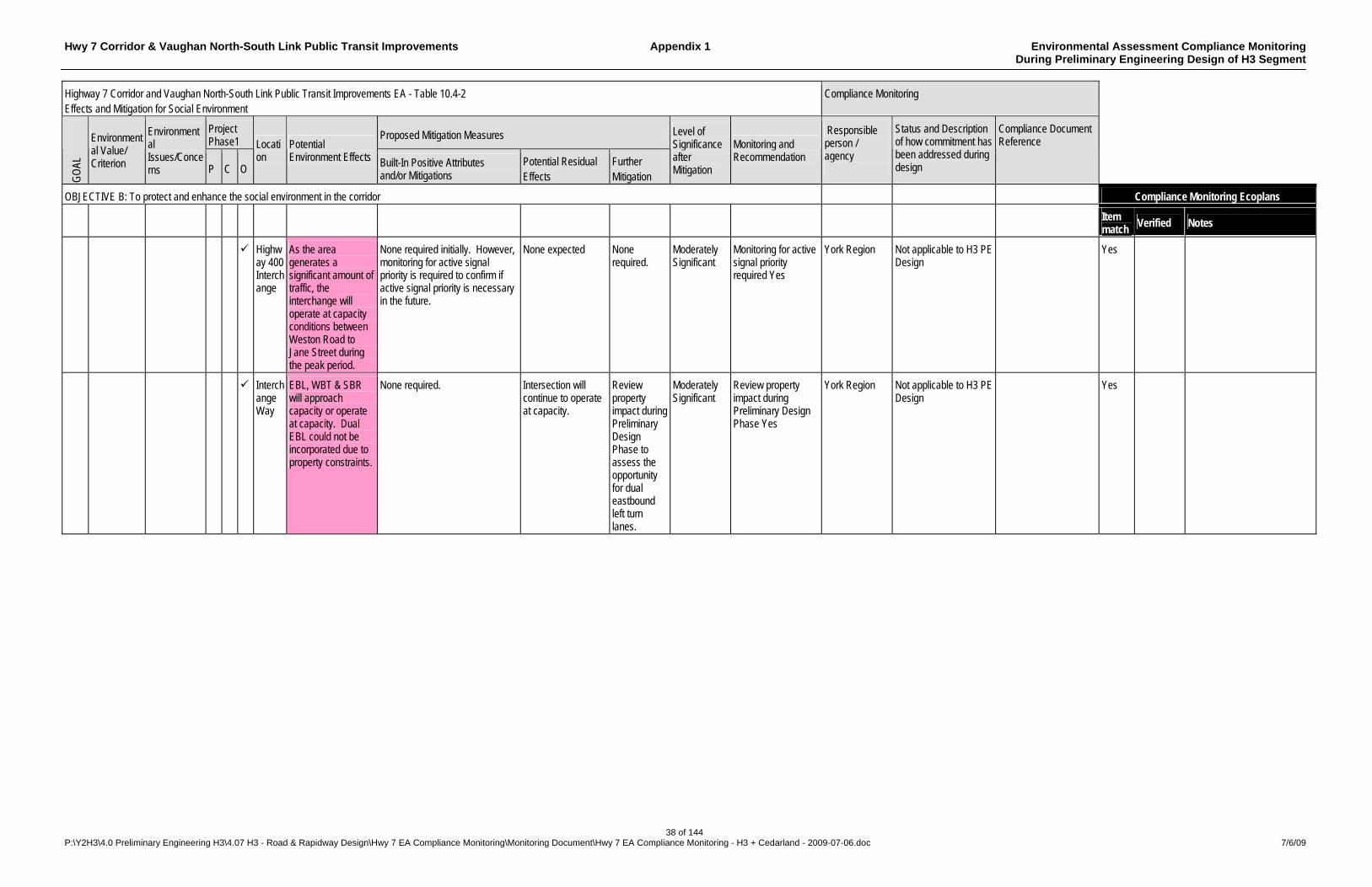
Hwy 7 Corridor & Vaughan North-South Link Public Transit Improvements Appendix 1 Environmental Assessment Compliance Monitoring During Preliminary Engineering Design of H3 Segment
38 of 144 P:\Y2H3\4.0 Preliminary Engineering H3\4.07 H3 - Road & Rapidway Design\Hwy 7 EA Compliance Monitoring\Monitoring Document\Hwy 7 EA Compliance Monitoring - H3 + Cedarland - 2009-07-06.doc 7/6/09
Highway 7 Corridor and Vaughan North-South Link Public Transit Improvements EA - Table 10.4-2 Effects and Mitigation for Social Environment
Compliance Monitoring
Project Phase1
Proposed Mitigation Measures
GO
AL
Environmental Value/ Criterion
Environmental Issues/Concerns P C O
Location
Potential Environment Effects Built-In Positive Attributes
and/or Mitigations Potential Residual Effects
Further Mitigation
Level of Significance after Mitigation
Monitoring and Recommendation
Responsible person / agency
Status and Description of how commitment has been addressed during design
Compliance Document Reference
OBJECTIVE B: To protect and enhance the social environment in the corridor Compliance Monitoring Ecoplans
Item match
Verified Notes
Highway 400 Interchange
As the area generates a significant amount of traffic, the interchange will operate at capacity conditions between Weston Road to Jane Street during the peak period.
None required initially. However, monitoring for active signal priority is required to confirm if active signal priority is necessary in the future.
None expected None required.
Moderately Significant
Monitoring for active signal priority required Yes
York Region Not applicable to H3 PE Design
Yes
Interchange Way
EBL, WBT & SBR will approach capacity or operate at capacity. Dual EBL could not be incorporated due to property constraints.
None required. Intersection will continue to operate at capacity.
Review property impact during Preliminary Design Phase to assess the opportunity for dual eastbound left turn lanes.
Moderately Significant
Review property impact during Preliminary Design Phase Yes
York Region Not applicable to H3 PE Design
Yes

Hwy 7 Corridor & Vaughan North-South Link Public Transit Improvements Appendix 1 Environmental Assessment Compliance Monitoring During Preliminary Engineering Design of H3 Segment
39 of 144 P:\Y2H3\4.0 Preliminary Engineering H3\4.07 H3 - Road & Rapidway Design\Hwy 7 EA Compliance Monitoring\Monitoring Document\Hwy 7 EA Compliance Monitoring - H3 + Cedarland - 2009-07-06.doc 7/6/09
Highway 7 Corridor and Vaughan North-South Link Public Transit Improvements EA - Table 10.4-2 Effects and Mitigation for Social Environment
Compliance Monitoring
Project Phase1
Proposed Mitigation Measures
GO
AL
Environmental Value/ Criterion
Environmental Issues/Concerns P C O
Location
Potential Environment Effects Built-In Positive Attributes
and/or Mitigations Potential Residual Effects
Further Mitigation
Level of Significance after Mitigation
Monitoring and Recommendation
Responsible person / agency
Status and Description of how commitment has been addressed during design
Compliance Document Reference
OBJECTIVE B: To protect and enhance the social environment in the corridor Compliance Monitoring Ecoplans
Item match
Verified Notes
B2 cont’d
Maintain or improve road traffic and pedestrian circulation (cont’d)
Reduction in main street intersection capacities due to rapid transit operations (cont’d)
Jane Street
Some transit vehicles are required to turn south to reach the York University.
A ten second transit phase will be provided to facilitate the movements. The NB exclusive right turn lane will be permitted during the transit phase. Review opportunities for road network improvements to improve left turn lane capacity issues.
The intersection of Highway 7 and Jane Street will operate at capacity during both peak periods. The protected left turn restrictions resulting from the RT system will result in the eastbound and westbound left turns operating at capacity.
Split phasing should be considered during the detailed design phase to provide a minimum split for the N-S pedestrian movement. Review opportunities for road network improvements to improve left turn lane capacity issues.
Moderately Significant
Monitoring required for implementation of split phasing. Review opportunities for road network improvements to improve left turn lane capacity issues. Yes
York Region Not applicable to H3 PE Design
Yes
Interchange Way (Jane Street)
East approach is operating as a shared left-through and shared through-right. Heavy left turn volumes suggest an exclusive or dual westbound left turn lane is required.
Monitor east approach for widening
Intersection will continue to operate at capacity.
None expected
Moderately Significant
Recommend further intersection analysis during Preliminary Design Phase to determine if exclusive WB left turn widening is warranted. Yes
York Region Not applicable to H3 PE Design
Yes
Proposed East-West Road (Jane Street)
Under 2021 Considerations, SBL will operate at capacity and NBT will approach capacity during the AM peak hour. The opposing WBR will approach capacity during the PM peak hour.
Traffic volume should be monitored to determine if a SB dual left turn lane will be required to facility the heavy volume during the morning period.
Intersection will continue to operate at capacity.
None expected
Moderately Significant
Monitoring required for SB dual left turn lane. Yes
York Region Not applicable to H3 PE Design
Yes
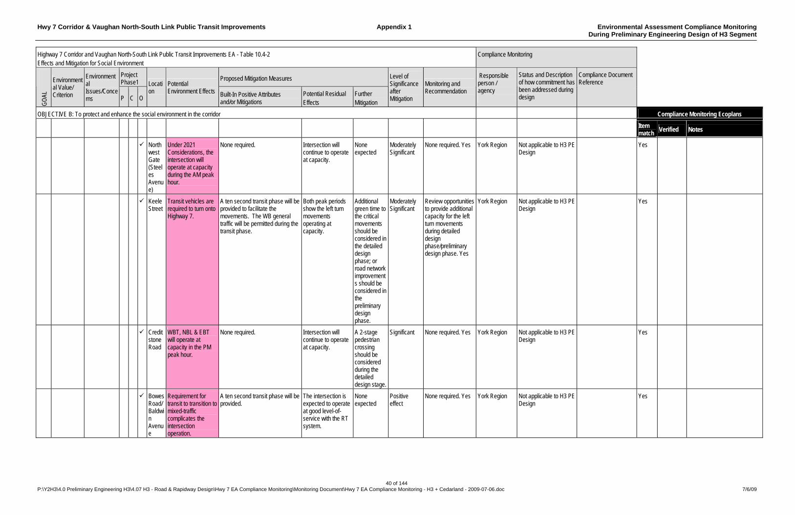
Hwy 7 Corridor & Vaughan North-South Link Public Transit Improvements Appendix 1 Environmental Assessment Compliance Monitoring During Preliminary Engineering Design of H3 Segment
40 of 144 P:\Y2H3\4.0 Preliminary Engineering H3\4.07 H3 - Road & Rapidway Design\Hwy 7 EA Compliance Monitoring\Monitoring Document\Hwy 7 EA Compliance Monitoring - H3 + Cedarland - 2009-07-06.doc 7/6/09
Highway 7 Corridor and Vaughan North-South Link Public Transit Improvements EA - Table 10.4-2 Effects and Mitigation for Social Environment
Compliance Monitoring
Project Phase1
Proposed Mitigation Measures
GO
AL
Environmental Value/ Criterion
Environmental Issues/Concerns P C O
Location
Potential Environment Effects Built-In Positive Attributes
and/or Mitigations Potential Residual Effects
Further Mitigation
Level of Significance after Mitigation
Monitoring and Recommendation
Responsible person / agency
Status and Description of how commitment has been addressed during design
Compliance Document Reference
OBJECTIVE B: To protect and enhance the social environment in the corridor Compliance Monitoring Ecoplans
Item match
Verified Notes
Northwest Gate (Steeles Avenue)
Under 2021 Considerations, the intersection will operate at capacity during the AM peak hour.
None required. Intersection will continue to operate at capacity.
None expected
Moderately Significant
None required. Yes York Region Not applicable to H3 PE Design
Yes
Keele Street
Transit vehicles are required to turn onto Highway 7.
A ten second transit phase will be provided to facilitate the movements. The WB general traffic will be permitted during the transit phase.
Both peak periods show the left turn movements operating at capacity.
Additional green time to the critical movements should be considered in the detailed design phase; or road network improvements should be considered in the preliminary design phase.
Moderately Significant
Review opportunities to provide additional capacity for the left turn movements during detailed design phase/preliminary design phase. Yes
York Region Not applicable to H3 PE Design
Yes
Creditstone Road
WBT, NBL & EBT will operate at capacity in the PM peak hour.
None required. Intersection will continue to operate at capacity.
A 2-stage pedestrian crossing should be considered during the detailed design stage.
Significant None required. Yes York Region Not applicable to H3 PE Design
Yes
Bowes Road/ Baldwin Avenue
Requirement for transit to transition to mixed-traffic complicates the intersection operation.
A ten second transit phase will be provided.
The intersection is expected to operate at good level-of-service with the RT system.
None expected
Positive effect
None required. Yes York Region Not applicable to H3 PE Design
Yes

Hwy 7 Corridor & Vaughan North-South Link Public Transit Improvements Appendix 1 Environmental Assessment Compliance Monitoring During Preliminary Engineering Design of H3 Segment
41 of 144 P:\Y2H3\4.0 Preliminary Engineering H3\4.07 H3 - Road & Rapidway Design\Hwy 7 EA Compliance Monitoring\Monitoring Document\Hwy 7 EA Compliance Monitoring - H3 + Cedarland - 2009-07-06.doc 7/6/09
Highway 7 Corridor and Vaughan North-South Link Public Transit Improvements EA - Table 10.4-2 Effects and Mitigation for Social Environment
Compliance Monitoring
Project Phase1
Proposed Mitigation Measures
GO
AL
Environmental Value/ Criterion
Environmental Issues/Concerns P C O
Location
Potential Environment Effects Built-In Positive Attributes
and/or Mitigations Potential Residual Effects
Further Mitigation
Level of Significance after Mitigation
Monitoring and Recommendation
Responsible person / agency
Status and Description of how commitment has been addressed during design
Compliance Document Reference
OBJECTIVE B: To protect and enhance the social environment in the corridor Compliance Monitoring Ecoplans
Item match
Verified Notes
Centre Street/ North Rivermede
Requirement for transit to transition to mixed-traffic complicates the intersection operation.
EB transit vehicle will utilize the existing channelized right turn lane and diverge into the transitway downstream of the intersection to avoid delay.
The intersection will operate at a satisfactory LOS. NBT & EBT will approach capacity. Minimal delays or queues are expected between the two transitional intersections.
None expected
Insignificant None required. Yes York Region Not applicable to H3 PE Design
Yes
B2 Cont’d
Maintain or improve road traffic and pedestrian circulation (cont’d)
Reduction in main street intersection capacities due to rapid transit operations (cont’d)
Centre/ Bathurst Streets
Transit vehicles are required to negotiate an EBL or SBR in the dedicated transit ROW.
EBL/SBR for transit, & EBL/EBT for general traffic has been permitted during a 10-second transit phase. All the left turn lanes operate under protected-permissive phases as the transit phase operate under an exclusive phase.
EBL, NBL & SBT will approach capacity in the PM peak hour.
None expected
Moderately Significant
None required. Yes York Region Not applicable to H3 PE Design
Yes
Worth Boulevard/Flamingo Road (Bathurst Street)
Requirement for transit to transition to mixed-traffic complicates the intersection operation.
A ten second transit phase will be provided. SBT will be permitted during this transit phase.
NBT will operate at capacity and SBT will approach capacity. Addition green time is required in the N-S direction.
Split phasing should be considered during the detailed design stage.
Significant Monitoring required for split phasing. Yes
York Region Not applicable to H3 PE Design
Yes
Bathurst Street Connection Road
Requirement for transit to transition to mixed-traffic complicates the intersection operation.
Three SB left turn lanes will be provided: one for an exclusive SB transit left turn lane; two for SB general left turn traffic. A dual EB left turn lane will be provided.
No capacity constraints.
None expected
Positive effect
None required. Yes York Region Not applicable to H3 PE Design
Yes
Hunter’s Point Drive
Requirement for transit to transition to mixed-traffic complicates the intersection operation.
A ten second transit phase will be provided. EBT will be permitted during this transit phase.
No capacity constraints.
None expected
Positive effect
None required. Yes York Region Not applicable to H3 PE Design
Yes
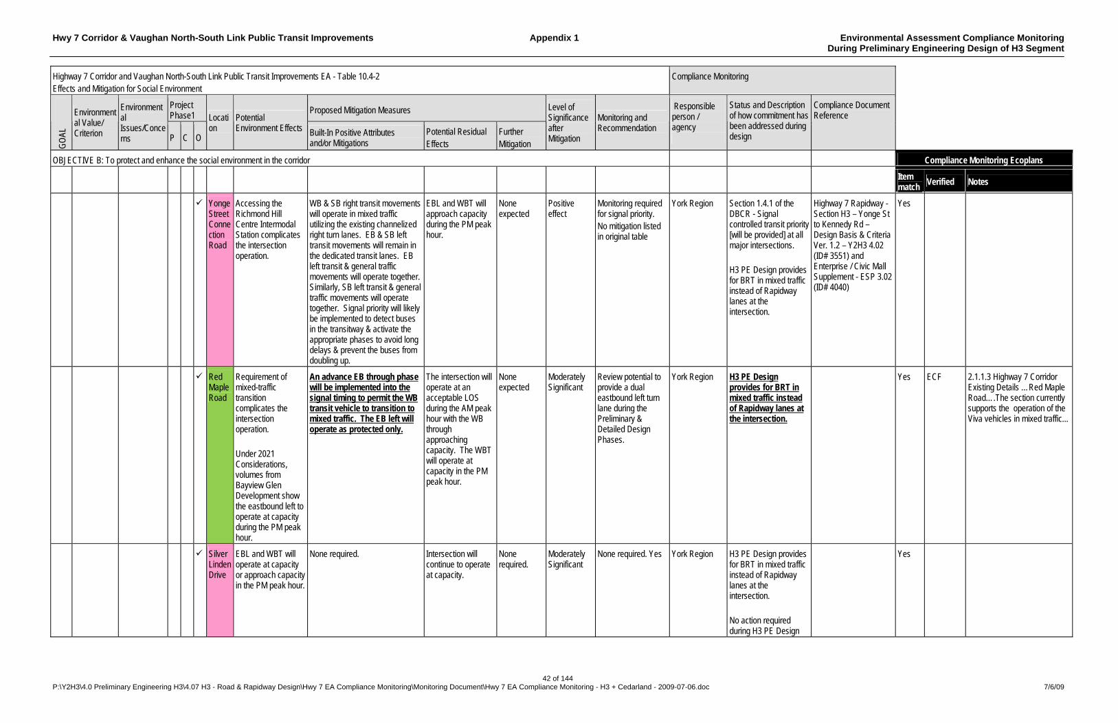
Hwy 7 Corridor & Vaughan North-South Link Public Transit Improvements Appendix 1 Environmental Assessment Compliance Monitoring During Preliminary Engineering Design of H3 Segment
42 of 144 P:\Y2H3\4.0 Preliminary Engineering H3\4.07 H3 - Road & Rapidway Design\Hwy 7 EA Compliance Monitoring\Monitoring Document\Hwy 7 EA Compliance Monitoring - H3 + Cedarland - 2009-07-06.doc 7/6/09
Highway 7 Corridor and Vaughan North-South Link Public Transit Improvements EA - Table 10.4-2 Effects and Mitigation for Social Environment
Compliance Monitoring
Project Phase1
Proposed Mitigation Measures
GO
AL
Environmental Value/ Criterion
Environmental Issues/Concerns P C O
Location
Potential Environment Effects Built-In Positive Attributes
and/or Mitigations Potential Residual Effects
Further Mitigation
Level of Significance after Mitigation
Monitoring and Recommendation
Responsible person / agency
Status and Description of how commitment has been addressed during design
Compliance Document Reference
OBJECTIVE B: To protect and enhance the social environment in the corridor Compliance Monitoring Ecoplans
Item match
Verified Notes
Yonge Street Connection Road
Accessing the Richmond Hill Centre Intermodal Station complicates the intersection operation.
WB & SB right transit movements will operate in mixed traffic utilizing the existing channelized right turn lanes. EB & SB left transit movements will remain in the dedicated transit lanes. EB left transit & general traffic movements will operate together. Similarly, SB left transit & general traffic movements will operate together. Signal priority will likely be implemented to detect buses in the transitway & activate the appropriate phases to avoid long delays & prevent the buses from doubling up.
EBL and WBT will approach capacity during the PM peak hour.
None expected
Positive effect
Monitoring required for signal priority. No mitigation listed in original table
York Region Section 1.4.1 of the DBCR - Signal controlled transit priority [will be provided] at all major intersections. H3 PE Design provides for BRT in mixed traffic instead of Rapidway lanes at the intersection.
Highway 7 Rapidway - Section H3 – Yonge St to Kennedy Rd – Design Basis & Criteria Ver. 1.2 – Y2H3 4.02 (ID# 3551) and Enterprise / Civic Mall Supplement - ESP 3.02 (ID# 4040)
Yes
Red Maple Road
Requirement of mixed-traffic transition complicates the intersection operation. Under 2021 Considerations, volumes from Bayview Glen Development show the eastbound left to operate at capacity during the PM peak hour.
An advance EB through phase will be implemented into the signal timing to permit the WB transit vehicle to transition to mixed traffic. The EB left will operate as protected only.
The intersection will operate at an acceptable LOS during the AM peak hour with the WB through approaching capacity. The WBT will operate at capacity in the PM peak hour.
None expected
Moderately Significant
Review potential to provide a dual eastbound left turn lane during the Preliminary & Detailed Design Phases.
York Region H3 PE Design provides for BRT in mixed traffic instead of Rapidway lanes at the intersection.
Yes ECF 2.1.1.3 Highway 7 Corridor Existing Details …Red Maple Road….The section currently supports the operation of the Viva vehicles in mixed traffic...
Silver Linden Drive
EBL and WBT will operate at capacity or approach capacity in the PM peak hour.
None required. Intersection will continue to operate at capacity.
None required.
Moderately Significant
None required. Yes York Region H3 PE Design provides for BRT in mixed traffic instead of Rapidway lanes at the intersection. No action required during H3 PE Design
Yes
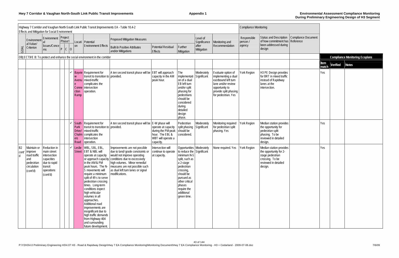
Hwy 7 Corridor & Vaughan North-South Link Public Transit Improvements Appendix 1 Environmental Assessment Compliance Monitoring During Preliminary Engineering Design of H3 Segment
43 of 144 P:\Y2H3\4.0 Preliminary Engineering H3\4.07 H3 - Road & Rapidway Design\Hwy 7 EA Compliance Monitoring\Monitoring Document\Hwy 7 EA Compliance Monitoring - H3 + Cedarland - 2009-07-06.doc 7/6/09
Highway 7 Corridor and Vaughan North-South Link Public Transit Improvements EA - Table 10.4-2 Effects and Mitigation for Social Environment
Compliance Monitoring
Project Phase1
Proposed Mitigation Measures
GO
AL
Environmental Value/ Criterion
Environmental Issues/Concerns P C O
Location
Potential Environment Effects Built-In Positive Attributes
and/or Mitigations Potential Residual Effects
Further Mitigation
Level of Significance after Mitigation
Monitoring and Recommendation
Responsible person / agency
Status and Description of how commitment has been addressed during design
Compliance Document Reference
OBJECTIVE B: To protect and enhance the social environment in the corridor Compliance Monitoring Ecoplans
Item match
Verified Notes
Bayview Avenue Connection Ramp
Requirement for transit to transition to mixed-traffic complicates the intersection operation.
A ten second transit phase will be provided.
EBT will approach capacity in the AM peak hour.
The implementation of a dual EB left turn and/or split phasing for pedestrians should be considered during detailed design phase.
Moderately Significant
Evaluate option of implementing a dual eastbound left turn lane and/or review opportunity to provide split phasing for pedestrian. Yes
York Region H3 PE Design provides for BRT in mixed traffic instead of Rapidway lanes at the intersection.
Yes
South Park Drive/Chalmers Road
Requirement for transit to transition to mixed-traffic complicates the intersection operation.
A ten second transit phase will be provided.
E-W phase will operate at capacity during the PM peak hour. The EBL & WBT will operate a capacity.
Pedestrian split phasing should be considered.
Moderately Significant
Monitoring required for pedestrian split phasing. Yes
York Region Median station provides the opportunity for pedestrian split phasing. To be reviewed in detailed design.
Yes
B2 cont’d
Maintain or improve road traffic and pedestrian circulation (cont’d)
Reduction in main street intersection capacities due to rapid transit operations (cont’d)
Leslie Street
WBL, SBL, EBL, EBT & NBL will operate at capacity or approach capacity in the AM & PM peak hours. The N-S movements will require a minimum split of 49 s to serve pedestrian crossing times. Long-term conditions expect high vehicular volumes in all approaches. Additional road improvements are insignificant due to high traffic demands from Highway 404 and surrounding future development.
Improvements are not possible due to land/ grade constraints or would not improve operating conditions due to excessively high volumes. Minor remedial measures are not possible such as dual left turn lanes or signal modifications.
Intersection will continue to operate at capacity.
Opportunities to reduce the minimum N-S split, such as a 2-stage pedestrian crossing, should be pursued as other critical phases require the additional green time.
Moderately Significant
None required. Yes York Region Median station provides the opportunity for 2-stage pedestrian crossing. To be reviewed in detailed design.
Yes

Hwy 7 Corridor & Vaughan North-South Link Public Transit Improvements Appendix 1 Environmental Assessment Compliance Monitoring During Preliminary Engineering Design of H3 Segment
44 of 144 P:\Y2H3\4.0 Preliminary Engineering H3\4.07 H3 - Road & Rapidway Design\Hwy 7 EA Compliance Monitoring\Monitoring Document\Hwy 7 EA Compliance Monitoring - H3 + Cedarland - 2009-07-06.doc 7/6/09
Highway 7 Corridor and Vaughan North-South Link Public Transit Improvements EA - Table 10.4-2 Effects and Mitigation for Social Environment
Compliance Monitoring
Project Phase1
Proposed Mitigation Measures
GO
AL
Environmental Value/ Criterion
Environmental Issues/Concerns P C O
Location
Potential Environment Effects Built-In Positive Attributes
and/or Mitigations Potential Residual Effects
Further Mitigation
Level of Significance after Mitigation
Monitoring and Recommendation
Responsible person / agency
Status and Description of how commitment has been addressed during design
Compliance Document Reference
OBJECTIVE B: To protect and enhance the social environment in the corridor Compliance Monitoring Ecoplans
Item match
Verified Notes
East Beaver Creek/ Commerce Valley Drive East
EBL & WBL will operate at capacity due to the protected-only phases. The reduction in east-west capacity is mainly attributed to the additional north-south green time required to accommodate pedestrians. Heavy volumes and proximity to the Highway 404 interchange result in capacity conditions with minimal improvement from minor remedial measures.
Improvements are not possible due to land/ grade constraints or would not improve operating conditions due to excessively high volumes. Minor remedial measures are not possible such as dual left turn lanes or signal modifications.
Intersection will continue to operate at capacity.
None expected
Significant A two-stage pedestrian crossing should be considered at the Commerce Valley Drive intersection to reduce side street green time demands. Yes
York Region Median station provides the opportunity for 2-stage pedestrian crossing. To be reviewed in detailed design.
Yes
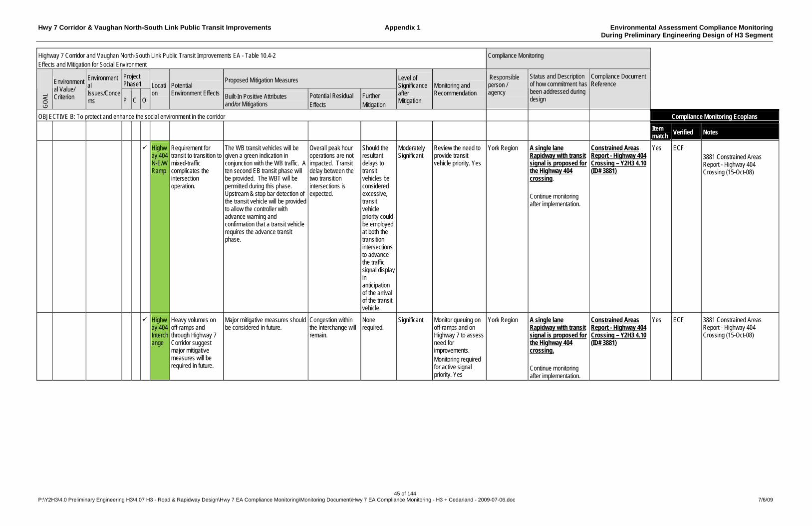
Hwy 7 Corridor & Vaughan North-South Link Public Transit Improvements Appendix 1 Environmental Assessment Compliance Monitoring During Preliminary Engineering Design of H3 Segment
45 of 144 P:\Y2H3\4.0 Preliminary Engineering H3\4.07 H3 - Road & Rapidway Design\Hwy 7 EA Compliance Monitoring\Monitoring Document\Hwy 7 EA Compliance Monitoring - H3 + Cedarland - 2009-07-06.doc 7/6/09
Highway 7 Corridor and Vaughan North-South Link Public Transit Improvements EA - Table 10.4-2 Effects and Mitigation for Social Environment
Compliance Monitoring
Project Phase1
Proposed Mitigation Measures
GO
AL
Environmental Value/ Criterion
Environmental Issues/Concerns P C O
Location
Potential Environment Effects Built-In Positive Attributes
and/or Mitigations Potential Residual Effects
Further Mitigation
Level of Significance after Mitigation
Monitoring and Recommendation
Responsible person / agency
Status and Description of how commitment has been addressed during design
Compliance Document Reference
OBJECTIVE B: To protect and enhance the social environment in the corridor Compliance Monitoring Ecoplans
Item match
Verified Notes
Highway 404 N-E/W Ramp
Requirement for transit to transition to mixed-traffic complicates the intersection operation.
The WB transit vehicles will be given a green indication in conjunction with the WB traffic. A ten second EB transit phase will be provided. The WBT will be permitted during this phase. Upstream & stop bar detection of the transit vehicle will be provided to allow the controller with advance warning and confirmation that a transit vehicle requires the advance transit phase.
Overall peak hour operations are not impacted. Transit delay between the two transition intersections is expected.
Should the resultant delays to transit vehicles be considered excessive, transit vehicle priority could be employed at both the transition intersections to advance the traffic signal display in anticipation of the arrival of the transit vehicle.
Moderately Significant
Review the need to provide transit vehicle priority. Yes
York Region A single lane Rapidway with transit signal is proposed for the Highway 404 crossing. Continue monitoring after implementation.
Constrained Areas Report - Highway 404 Crossing – Y2H3 4.10 (ID# 3881)
Yes ECF 3881 Constrained Areas Report - Highway 404 Crossing (15-Oct-08)
Highway 404 Interchange
Heavy volumes on off-ramps and through Highway 7 Corridor suggest major mitigative measures will be required in future.
Major mitigative measures should be considered in future.
Congestion within the interchange will remain.
None required.
Significant Monitor queuing on off-ramps and on Highway 7 to assess need for improvements. Monitoring required for active signal priority. Yes
York Region A single lane Rapidway with transit signal is proposed for the Highway 404 crossing. Continue monitoring after implementation.
Constrained Areas Report - Highway 404 Crossing – Y2H3 4.10 (ID# 3881)
Yes ECF 3881 Constrained Areas Report - Highway 404 Crossing (15-Oct-08)
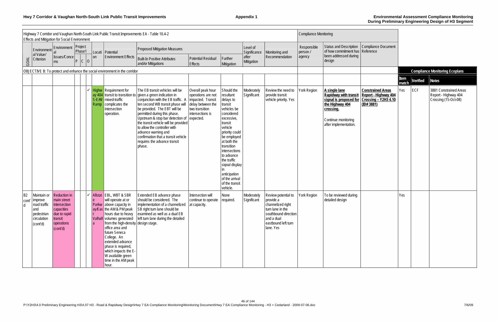
Hwy 7 Corridor & Vaughan North-South Link Public Transit Improvements Appendix 1 Environmental Assessment Compliance Monitoring During Preliminary Engineering Design of H3 Segment
46 of 144 P:\Y2H3\4.0 Preliminary Engineering H3\4.07 H3 - Road & Rapidway Design\Hwy 7 EA Compliance Monitoring\Monitoring Document\Hwy 7 EA Compliance Monitoring - H3 + Cedarland - 2009-07-06.doc 7/6/09
Highway 7 Corridor and Vaughan North-South Link Public Transit Improvements EA - Table 10.4-2 Effects and Mitigation for Social Environment
Compliance Monitoring
Project Phase1
Proposed Mitigation Measures
GO
AL
Environmental Value/ Criterion
Environmental Issues/Concerns P C O
Location
Potential Environment Effects Built-In Positive Attributes
and/or Mitigations Potential Residual Effects
Further Mitigation
Level of Significance after Mitigation
Monitoring and Recommendation
Responsible person / agency
Status and Description of how commitment has been addressed during design
Compliance Document Reference
OBJECTIVE B: To protect and enhance the social environment in the corridor Compliance Monitoring Ecoplans
Item match
Verified Notes
Highway 404 S-E/W Ramp
Requirement for transit to transition to mixed-traffic complicates the intersection operation.
The EB transit vehicles will be given a green indication in conjunction with the EB traffic. A ten second WB transit phase will be provided. The EBT will be permitted during this phase. Upstream & stop bar detection of the transit vehicle will be provided to allow the controller with advance warning and confirmation that a transit vehicle requires the advance transit phase.
Overall peak hour operations are not impacted. Transit delay between the two transition intersections is expected.
Should the resultant delays to transit vehicles be considered excessive, transit vehicle priority could be employed at both the transition intersections to advance the traffic signal display in anticipation of the arrival of the transit vehicle.
Moderately Significant
Review the need to provide transit vehicle priority. Yes
York Region A single lane Rapidway with transit signal is proposed for the Highway 404 crossing. Continue monitoring after implementation.
Constrained Areas Report - Highway 404 Crossing – Y2H3 4.10 (ID# 3881)
Yes ECF 3881 Constrained Areas Report - Highway 404 Crossing (15-Oct-08)
B2 cont’d
Maintain or improve road traffic and pedestrian circulation (cont’d)
Reduction in main street intersection capacities due to rapid transit operations (cont’d)
Allstate Parkway/East Valhalla
EBL, WBT & SBR will operate at or above capacity in the AM & PM peak hours due to heavy volumes generated from the high-density office area and future Seneca College. An extended advance phase is required, which impacts the E-W available green time in the AM peak hour.
Extended EB advance phase should be considered. The implementation of a channelized SB right turn lane should be examined as well as a dual EB left turn lane during the detailed design stage.
Intersection will continue to operate at capacity.
None required.
Moderately Significant
Review potential to provide a channelized right turn lane in the southbound direction and a dual eastbound left turn lane. Yes
York Region To be reviewed during detailed design
Yes

Hwy 7 Corridor & Vaughan North-South Link Public Transit Improvements Appendix 1 Environmental Assessment Compliance Monitoring During Preliminary Engineering Design of H3 Segment
47 of 144 P:\Y2H3\4.0 Preliminary Engineering H3\4.07 H3 - Road & Rapidway Design\Hwy 7 EA Compliance Monitoring\Monitoring Document\Hwy 7 EA Compliance Monitoring - H3 + Cedarland - 2009-07-06.doc 7/6/09
Highway 7 Corridor and Vaughan North-South Link Public Transit Improvements EA - Table 10.4-2 Effects and Mitigation for Social Environment
Compliance Monitoring
Project Phase1
Proposed Mitigation Measures
GO
AL
Environmental Value/ Criterion
Environmental Issues/Concerns P C O
Location
Potential Environment Effects Built-In Positive Attributes
and/or Mitigations Potential Residual Effects
Further Mitigation
Level of Significance after Mitigation
Monitoring and Recommendation
Responsible person / agency
Status and Description of how commitment has been addressed during design
Compliance Document Reference
OBJECTIVE B: To protect and enhance the social environment in the corridor Compliance Monitoring Ecoplans
Item match
Verified Notes
Town Centre Boulevard (Town Centre Blvd. Alignment)
Transit vehicles are required to negotiate an EBR or NBL in the dedicated transit ROW.
EBR/NBL for transit, & WBT for general traffic has been permitted during a dedicated 10-second transit phase. The WBL will operate as protected-only in order to prohibit WBL vehicles from operating with the WBT volumes during the transit phase.
EBT will operate at capacity in the PM peak hour.
None required.
Significant None required. York Region No action required during H3 PE Design
Yes
Clegg Road
WBT, SBL, EBL & NBL will approach capacity in AM/PM peak hour.
None required. Intersection will continue to operate at capacity.
None required.
Significant None required. York Region No action required during H3 PE Design
Yes
Helen Avenue/ future North-South Connection Road
Transit vehicles are required to enter/exit the dedicated median transitway lanes.
An exclusive transit only phase will be provided.
Under 2021 Considerations, EBL & SBL will approach capacity in the AM/PM peak hour.
None required.
Significant None required. York Region PE Design of this section has not yet commenced.
Yes
Helen Avenue (Kennedy Road)
Transit vehicles are required to negotiate an EBL or SBR in the dedicated transit ROW. Under 2021 Considerations, heavy volumes generated from Markham Centre West and GO Unionville Station will result in capacity constraints on NBL, SBT & WBL during AM/PM peak hour.
A transit phase of 10 s has been incorporated into the signal timings to operate in conjunction with the EBL & EBT movements. Under 2021 Considerations, a dual northbound left and channelized right turn should be considered.
Intersection will continue to operate at capacity.
None required.
Significant Follow-up monitoring during full buildout conditions to examine the possibility of implementing a dual northbound left and channelized eastbound right turn lane.
York Region PE Design of this section has not yet commenced.
Yes

Hwy 7 Corridor & Vaughan North-South Link Public Transit Improvements Appendix 1 Environmental Assessment Compliance Monitoring During Preliminary Engineering Design of H3 Segment
48 of 144 P:\Y2H3\4.0 Preliminary Engineering H3\4.07 H3 - Road & Rapidway Design\Hwy 7 EA Compliance Monitoring\Monitoring Document\Hwy 7 EA Compliance Monitoring - H3 + Cedarland - 2009-07-06.doc 7/6/09
Highway 7 Corridor and Vaughan North-South Link Public Transit Improvements EA - Table 10.4-2 Effects and Mitigation for Social Environment
Compliance Monitoring
Project Phase1
Proposed Mitigation Measures
GO
AL
Environmental Value/ Criterion
Environmental Issues/Concerns P C O
Location
Potential Environment Effects Built-In Positive Attributes
and/or Mitigations Potential Residual Effects
Further Mitigation
Level of Significance after Mitigation
Monitoring and Recommendation
Responsible person / agency
Status and Description of how commitment has been addressed during design
Compliance Document Reference
OBJECTIVE B: To protect and enhance the social environment in the corridor Compliance Monitoring Ecoplans
Item match
Verified Notes
Avoca Drive(Kennedy Road)
Implementation of RT will reduce the intersection capacity. The proposed Markham Centre West developments at this intersection show heavy north-south volumes on Kennedy Road. WBL, NBL & EBL will approach capacity in AM/PM peak hour.
NBL & SBL will operate as protected left phases. Io reduce the northbound advance phase, improvements such as implementing a dual northbound left turn lane should be considered in the detailed design phase.
Intersection will continue to operate at capacity.
None required
Significant Follow-up monitoring to assess capacity issues during the PM peak hour with NB/SB through movements and the NB left.
York Region Not applicable to H3 PE Design
Yes
Kennedy Road
Transit vehicles are required to negotiate a NBR or WBL in the dedicated transit ROW.
A transit phase of 10 s has been incorporated into the signal timings to operate in conjunction with the WBT movements.
None expected. A 2-stage pedestrian crossing should be considered during detailed design phase to meet the minimum split requirements in both directions.
Moderately significant
A 2-stage pedestrian crossing should be considered during detailed design phase.
York Region Not applicable to H3 PE Design
Yes
Bullock Drive/ Commercial Access
EBL will operate at capacity as a protected left turn phase in PM peak hour.
None required Intersection will continue to operate at capacity.
None required
Moderately significant
None required York Region Not applicable to H3 PE Design
Yes

Hwy 7 Corridor & Vaughan North-South Link Public Transit Improvements Appendix 1 Environmental Assessment Compliance Monitoring During Preliminary Engineering Design of H3 Segment
49 of 144 P:\Y2H3\4.0 Preliminary Engineering H3\4.07 H3 - Road & Rapidway Design\Hwy 7 EA Compliance Monitoring\Monitoring Document\Hwy 7 EA Compliance Monitoring - H3 + Cedarland - 2009-07-06.doc 7/6/09
Highway 7 Corridor and Vaughan North-South Link Public Transit Improvements EA - Table 10.4-2 Effects and Mitigation for Social Environment
Compliance Monitoring
Project Phase1
Proposed Mitigation Measures
GO
AL
Environmental Value/ Criterion
Environmental Issues/Concerns P C O
Location
Potential Environment Effects Built-In Positive Attributes
and/or Mitigations Potential Residual Effects
Further Mitigation
Level of Significance after Mitigation
Monitoring and Recommendation
Responsible person / agency
Status and Description of how commitment has been addressed during design
Compliance Document Reference
OBJECTIVE B: To protect and enhance the social environment in the corridor Compliance Monitoring Ecoplans
Item match
Verified Notes
B2 Cont’d
Maintain or improve road traffic and pedestrian circulation (cont’d)
Reduction in main street intersection capacities due to rapid transit operations (cont’d)
McCowan Road
WBL & NBL will operate above capacity.
None required initially. Based on future operations, improvements to the westbound left and northbound left may be required to improve operations at the intersections during the AM peak hour. To improve operating conditions, a two-stage pedestrian crossing should be investigated in both directions during the detailed design stage.
Intersection will continue to operate at capacity.
None required
Significant Investigated the need to provide a two-stage pedestrian crossing in both directions during the detailed design stage. Review special needs for the westbound left and northbound left during the AM peak hour.
York Region Not applicable to H3 PE Design
Yes
Grandview Boulevard/ Galsworthy Drive
Requirement for transit to transition to mixed-traffic complicates the intersection operation.
A ten second transit phase will be provided.
The intersection is expected to operate at an acceptable LOS.
None required
Positive Effect
None required. York Region Not applicable to H3 PE Design
Yes
Main Street Markham
E-W main phase is reduced significantly due to the pedestrian crossing time requirements to cross Highway 7.
WBL will operate at capacity in the AM peak hour and WBL & NBL will approach capacity in the PM peak hour.
Intersection will continue to operate at capacity.
None required
Significant None required York Region Not applicable to H3 PE Design
Yes
Wooten Way
Requirement for transit to transition to mixed-traffic complicates the intersection operation.
A ten second transit phase will be provided.
The intersection is expected to operate at an acceptable LOS.
None required
Positive Effect
None required. York Region Not applicable to H3 PE Design
Yes
Ninth Line
Under 2021 considerations, EBL, SBT, NBL, NBT & WBT will approach capacity or operate at capacity in the AM/PM peak hour.
None required Intersection will continue to operate at capacity.
None required
Significant None required York Region Not applicable to H3 PE Design
Yes
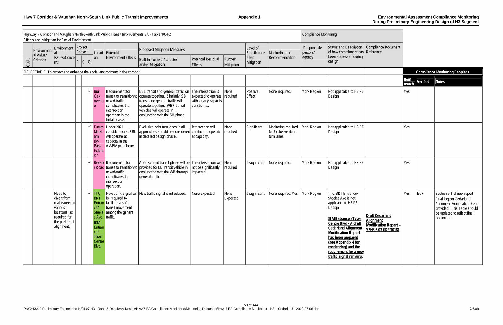
Hwy 7 Corridor & Vaughan North-South Link Public Transit Improvements Appendix 1 Environmental Assessment Compliance Monitoring During Preliminary Engineering Design of H3 Segment
50 of 144 P:\Y2H3\4.0 Preliminary Engineering H3\4.07 H3 - Road & Rapidway Design\Hwy 7 EA Compliance Monitoring\Monitoring Document\Hwy 7 EA Compliance Monitoring - H3 + Cedarland - 2009-07-06.doc 7/6/09
Highway 7 Corridor and Vaughan North-South Link Public Transit Improvements EA - Table 10.4-2 Effects and Mitigation for Social Environment
Compliance Monitoring
Project Phase1
Proposed Mitigation Measures
GO
AL
Environmental Value/ Criterion
Environmental Issues/Concerns P C O
Location
Potential Environment Effects Built-In Positive Attributes
and/or Mitigations Potential Residual Effects
Further Mitigation
Level of Significance after Mitigation
Monitoring and Recommendation
Responsible person / agency
Status and Description of how commitment has been addressed during design
Compliance Document Reference
OBJECTIVE B: To protect and enhance the social environment in the corridor Compliance Monitoring Ecoplans
Item match
Verified Notes
Bur Oak Avenue
Requirement for transit to transition to mixed-traffic complicates the intersection operation in the initial phase.
EBL transit and general traffic will operate together. Similarly, SB transit and general traffic will operate together. WBR transit vehicles will operate in conjunction with the SB phase.
The intersection is expected to operate without any capacity constraints.
None required
Positive Effect
None required. York Region Not applicable to H3 PE Design
Yes
Future Markham By-Pass Extension
Under 2021 considerations, SBL will operate at capacity in the AM/PM peak hours.
Exclusive right turn lanes in all approaches should be considered in detailed design phase.
Intersection will continue to operate at capacity.
None required
Significant Monitoring required for Exclusive right turn lanes.
York Region Not applicable to H3 PE Design
Yes
Reesor Road
Requirement for transit to transition to mixed-traffic complicates the intersection operation.
A ten second transit phase will be provided for EB transit vehicle in conjunction with the WB through general traffic.
The intersection will not be significantly impacted.
None required
Insignificant None required. York Region Not applicable to H3 PE Design
Yes
Need to divert from main street at various locations, as required for the preferred alignment.
TTC BRT Entrance/ Steeles Ave. IBM Entrance/ Town Centre Blvd.
New traffic signal will be required to facilitate a safe transit movement among the general traffic.
New traffic signal is introduced. None expected. None Expected
Insignificant None required. Yes York Region TTC BRT Entrance/ Steeles Ave is not applicable to H3 PE Design IBM Entrance / Town Centre Blvd - A draft Cedarland Alignment Modification Report has been prepared (see Appendix 4 for monitoring) and the requirement for a new traffic signal remains.
Draft Cedarland Alignment Modification Report – Y2H3 6.03 (ID# 3018)
Yes ECF Section 5.1 of new report Final Report Cedarland Alignment Modification Report provided. This Table should be updated to reflect final document.
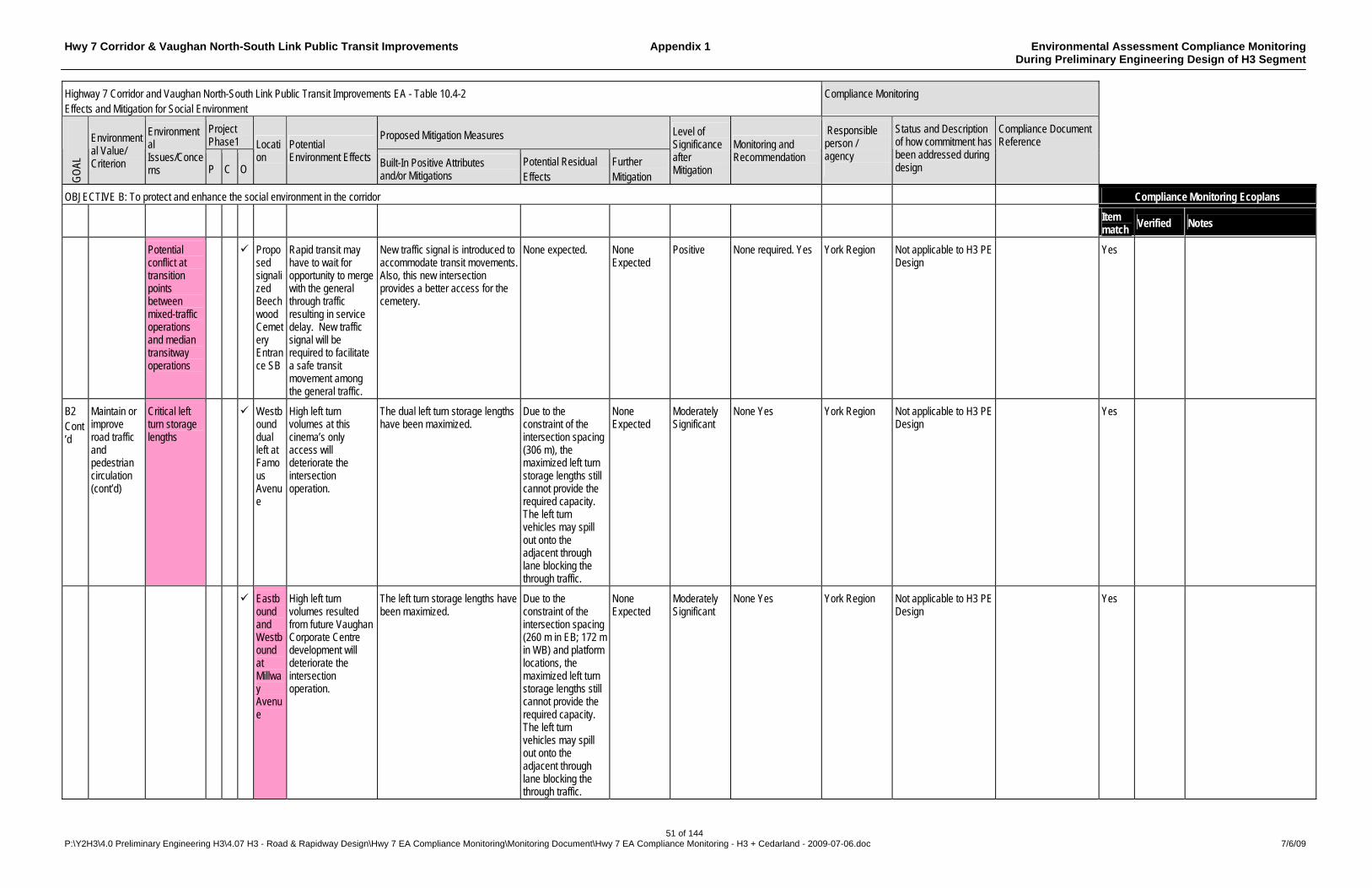
Hwy 7 Corridor & Vaughan North-South Link Public Transit Improvements Appendix 1 Environmental Assessment Compliance Monitoring During Preliminary Engineering Design of H3 Segment
51 of 144 P:\Y2H3\4.0 Preliminary Engineering H3\4.07 H3 - Road & Rapidway Design\Hwy 7 EA Compliance Monitoring\Monitoring Document\Hwy 7 EA Compliance Monitoring - H3 + Cedarland - 2009-07-06.doc 7/6/09
Highway 7 Corridor and Vaughan North-South Link Public Transit Improvements EA - Table 10.4-2 Effects and Mitigation for Social Environment
Compliance Monitoring
Project Phase1
Proposed Mitigation Measures
GO
AL
Environmental Value/ Criterion
Environmental Issues/Concerns P C O
Location
Potential Environment Effects Built-In Positive Attributes
and/or Mitigations Potential Residual Effects
Further Mitigation
Level of Significance after Mitigation
Monitoring and Recommendation
Responsible person / agency
Status and Description of how commitment has been addressed during design
Compliance Document Reference
OBJECTIVE B: To protect and enhance the social environment in the corridor Compliance Monitoring Ecoplans
Item match
Verified Notes
Potential conflict at transition points between mixed-traffic operations and median transitway operations
Proposed signalized Beechwood Cemetery Entrance SB
Rapid transit may have to wait for opportunity to merge with the general through traffic resulting in service delay. New traffic signal will be required to facilitate a safe transit movement among the general traffic.
New traffic signal is introduced to accommodate transit movements. Also, this new intersection provides a better access for the cemetery.
None expected. None Expected
Positive None required. Yes York Region Not applicable to H3 PE Design
Yes
B2 Cont’d
Maintain or improve road traffic and pedestrian circulation (cont’d)
Critical left turn storage lengths
Westbound dual left at Famous Avenue
High left turn volumes at this cinema’s only access will deteriorate the intersection operation.
The dual left turn storage lengths have been maximized.
Due to the constraint of the intersection spacing (306 m), the maximized left turn storage lengths still cannot provide the required capacity. The left turn vehicles may spill out onto the adjacent through lane blocking the through traffic.
None Expected
Moderately Significant
None Yes York Region Not applicable to H3 PE Design
Yes
Eastbound and Westbound at Millway Avenue
High left turn volumes resulted from future Vaughan Corporate Centre development will deteriorate the intersection operation.
The left turn storage lengths have been maximized.
Due to the constraint of the intersection spacing (260 m in EB; 172 m in WB) and platform locations, the maximized left turn storage lengths still cannot provide the required capacity. The left turn vehicles may spill out onto the adjacent through lane blocking the through traffic.
None Expected
Moderately Significant
None Yes York Region Not applicable to H3 PE Design
Yes
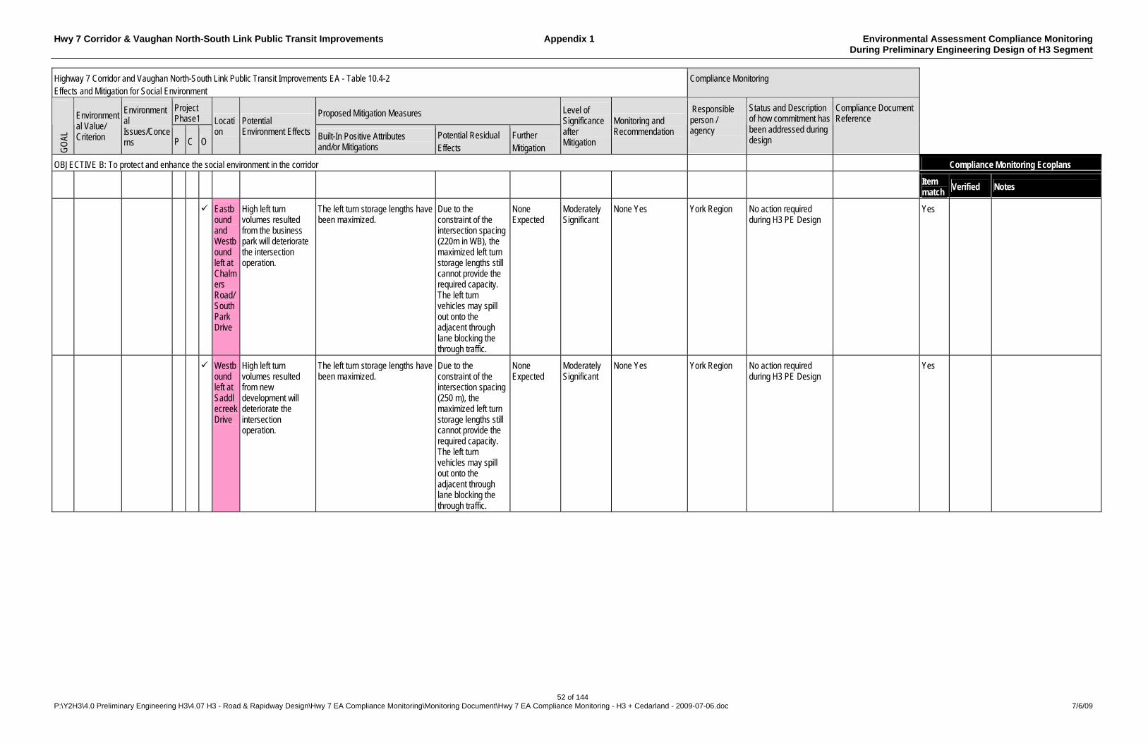
Hwy 7 Corridor & Vaughan North-South Link Public Transit Improvements Appendix 1 Environmental Assessment Compliance Monitoring During Preliminary Engineering Design of H3 Segment
52 of 144 P:\Y2H3\4.0 Preliminary Engineering H3\4.07 H3 - Road & Rapidway Design\Hwy 7 EA Compliance Monitoring\Monitoring Document\Hwy 7 EA Compliance Monitoring - H3 + Cedarland - 2009-07-06.doc 7/6/09
Highway 7 Corridor and Vaughan North-South Link Public Transit Improvements EA - Table 10.4-2 Effects and Mitigation for Social Environment
Compliance Monitoring
Project Phase1
Proposed Mitigation Measures
GO
AL
Environmental Value/ Criterion
Environmental Issues/Concerns P C O
Location
Potential Environment Effects Built-In Positive Attributes
and/or Mitigations Potential Residual Effects
Further Mitigation
Level of Significance after Mitigation
Monitoring and Recommendation
Responsible person / agency
Status and Description of how commitment has been addressed during design
Compliance Document Reference
OBJECTIVE B: To protect and enhance the social environment in the corridor Compliance Monitoring Ecoplans
Item match
Verified Notes
Eastbound and Westbound left at Chalmers Road/ South Park Drive
High left turn volumes resulted from the business park will deteriorate the intersection operation.
The left turn storage lengths have been maximized.
Due to the constraint of the intersection spacing (220m in WB), the maximized left turn storage lengths still cannot provide the required capacity. The left turn vehicles may spill out onto the adjacent through lane blocking the through traffic.
None Expected
Moderately Significant
None Yes York Region No action required during H3 PE Design
Yes
Westbound left at Saddlecreek Drive
High left turn volumes resulted from new development will deteriorate the intersection operation.
The left turn storage lengths have been maximized.
Due to the constraint of the intersection spacing (250 m), the maximized left turn storage lengths still cannot provide the required capacity. The left turn vehicles may spill out onto the adjacent through lane blocking the through traffic.
None Expected
Moderately Significant
None Yes York Region No action required during H3 PE Design
Yes
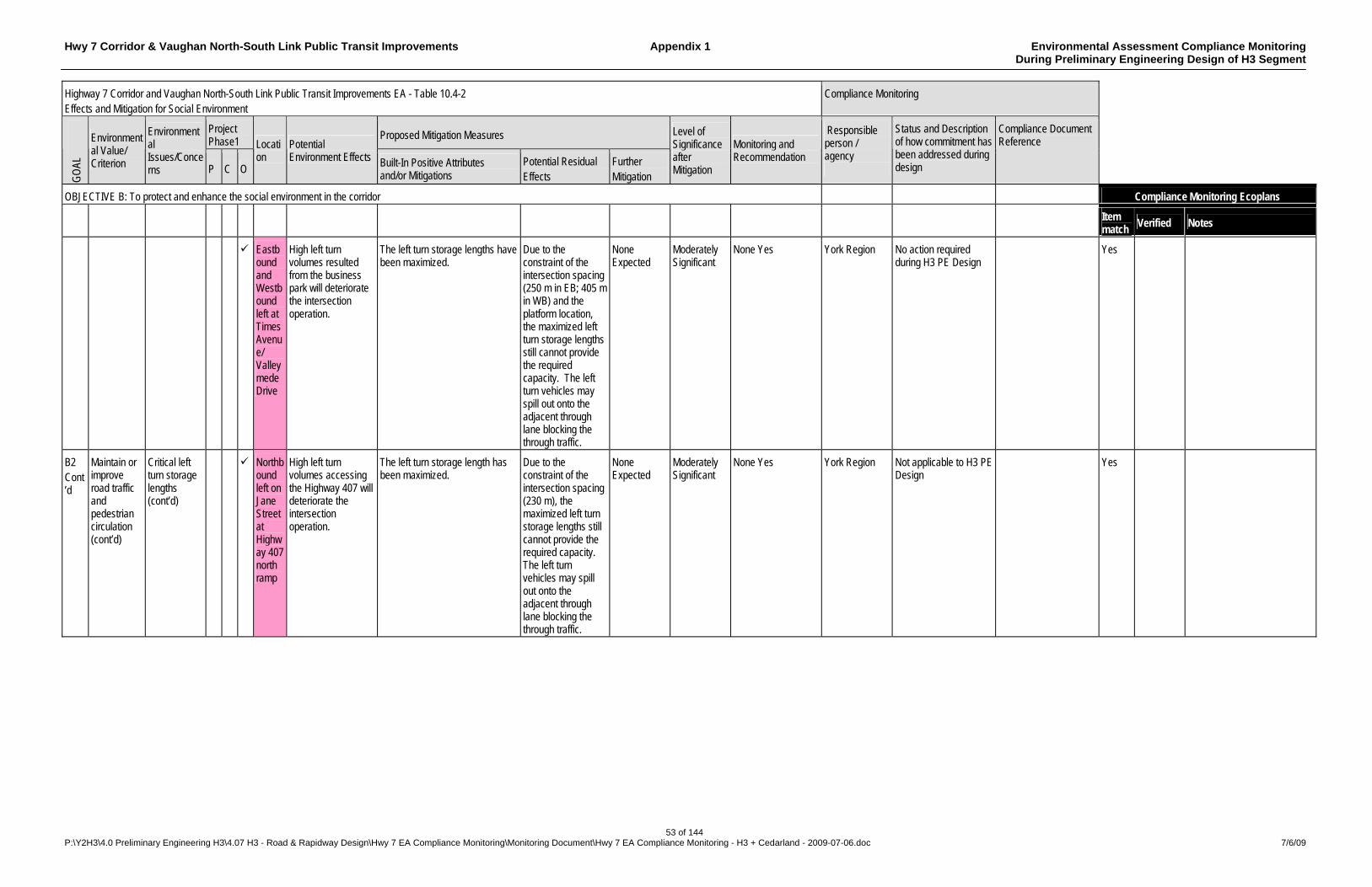
Hwy 7 Corridor & Vaughan North-South Link Public Transit Improvements Appendix 1 Environmental Assessment Compliance Monitoring During Preliminary Engineering Design of H3 Segment
53 of 144 P:\Y2H3\4.0 Preliminary Engineering H3\4.07 H3 - Road & Rapidway Design\Hwy 7 EA Compliance Monitoring\Monitoring Document\Hwy 7 EA Compliance Monitoring - H3 + Cedarland - 2009-07-06.doc 7/6/09
Highway 7 Corridor and Vaughan North-South Link Public Transit Improvements EA - Table 10.4-2 Effects and Mitigation for Social Environment
Compliance Monitoring
Project Phase1
Proposed Mitigation Measures
GO
AL
Environmental Value/ Criterion
Environmental Issues/Concerns P C O
Location
Potential Environment Effects Built-In Positive Attributes
and/or Mitigations Potential Residual Effects
Further Mitigation
Level of Significance after Mitigation
Monitoring and Recommendation
Responsible person / agency
Status and Description of how commitment has been addressed during design
Compliance Document Reference
OBJECTIVE B: To protect and enhance the social environment in the corridor Compliance Monitoring Ecoplans
Item match
Verified Notes
Eastbound and Westbound left at Times Avenue/ Valleymede Drive
High left turn volumes resulted from the business park will deteriorate the intersection operation.
The left turn storage lengths have been maximized.
Due to the constraint of the intersection spacing (250 m in EB; 405 m in WB) and the platform location, the maximized left turn storage lengths still cannot provide the required capacity. The left turn vehicles may spill out onto the adjacent through lane blocking the through traffic.
None Expected
Moderately Significant
None Yes York Region No action required during H3 PE Design
Yes
B2 Cont’d
Maintain or improve road traffic and pedestrian circulation (cont’d)
Critical left turn storage lengths (cont’d)
Northbound left on Jane Street at Highway 407 north ramp
High left turn volumes accessing the Highway 407 will deteriorate the intersection operation.
The left turn storage length has been maximized.
Due to the constraint of the intersection spacing (230 m), the maximized left turn storage lengths still cannot provide the required capacity. The left turn vehicles may spill out onto the adjacent through lane blocking the through traffic.
None Expected
Moderately Significant
None Yes York Region Not applicable to H3 PE Design
Yes
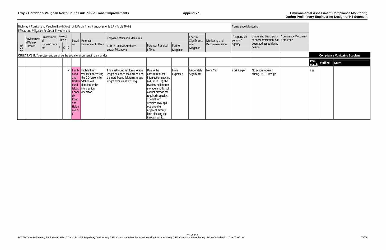
Hwy 7 Corridor & Vaughan North-South Link Public Transit Improvements Appendix 1 Environmental Assessment Compliance Monitoring During Preliminary Engineering Design of H3 Segment
54 of 144 P:\Y2H3\4.0 Preliminary Engineering H3\4.07 H3 - Road & Rapidway Design\Hwy 7 EA Compliance Monitoring\Monitoring Document\Hwy 7 EA Compliance Monitoring - H3 + Cedarland - 2009-07-06.doc 7/6/09
Highway 7 Corridor and Vaughan North-South Link Public Transit Improvements EA - Table 10.4-2 Effects and Mitigation for Social Environment
Compliance Monitoring
Project Phase1
Proposed Mitigation Measures
GO
AL
Environmental Value/ Criterion
Environmental Issues/Concerns P C O
Location
Potential Environment Effects Built-In Positive Attributes
and/or Mitigations Potential Residual Effects
Further Mitigation
Level of Significance after Mitigation
Monitoring and Recommendation
Responsible person / agency
Status and Description of how commitment has been addressed during design
Compliance Document Reference
OBJECTIVE B: To protect and enhance the social environment in the corridor Compliance Monitoring Ecoplans
Item match
Verified Notes
Eastbound and Northbound left at Kennedy Road and Helen Avenue
High left turn volumes accessing the GO Unionville Station will deteriorate the intersection operation.
The eastbound left turn storage length has been maximized and the northbound left turn storage length remains as existing.
Due to the constraint of the intersection spacing (245 m in EB), the maximized left turn storage lengths still cannot provide the required capacity. The left turn vehicles may spill out onto the adjacent through lane blocking the through traffic.
None Expected
Moderately Significant
None Yes York Region No action required during H3 PE Design
Yes

Hwy 7 Corridor & Vaughan North-South Link Public Transit Improvements Appendix 1 Environmental Assessment Compliance Monitoring During Preliminary Engineering Design of H3 Segment
55 of 144 P:\Y2H3\4.0 Preliminary Engineering H3\4.07 H3 - Road & Rapidway Design\Hwy 7 EA Compliance Monitoring\Monitoring Document\Hwy 7 EA Compliance Monitoring - H3 + Cedarland - 2009-07-06.doc 7/6/09
Highway 7 Corridor and Vaughan North-South Link Public Transit Improvements EA - Table 10.4-2 Effects and Mitigation for Social Environment
Compliance Monitoring
Project Phase1
Proposed Mitigation Measures
GO
AL
Environmental Value/ Criterion
Environmental Issues/Concerns P C O
Location
Potential Environment Effects Built-In Positive Attributes
and/or Mitigations Potential Residual Effects
Further Mitigation
Level of Significance after Mitigation
Monitoring and Recommendation
Responsible person / agency
Status and Description of how commitment has been addressed during design
Compliance Document Reference
OBJECTIVE B: To protect and enhance the social environment in the corridor Compliance Monitoring Ecoplans
Item match
Verified Notes
Widening or construction of new structures resulting in major temporary disruption to highway or railway traffic during construction
Hwy 427 CP Mactier Hwy 400 McMillian Yard Hwy 407/ Jane St. CN Halton CN Bradford Hwy 407/ Bathurst St. Yonge St. CN Bala Future Cedar Ave. Bayview Ave. Hwy 404 CP Havelock
Construction staging at busy highway interchanges, such as at Hwy 404, could cause additional delay to general traffic. Temporary relocation of railway lines could cause delay to railway traffic.
Mitigation in the form of traffic accommodation plans and temporary works will be developed for all structures where disruption is unavoidable. Mixed traffic operation is introduced in the area of CP Mactier, CN Halton, CN Bradford, Hwy 407/ Bathurst St., Bayview Ave., CN Bala, Hwy 404 and CP Havelock to avoid widening of structures. Lane reduction is used at Hwy 400 to minimize the widening of the structure. The widening of the rest of the structures is considered unavoidable.
Reduction in transit and general traffic operation speed. Some delays likely during construction period.
None Moderately significant
Monitor traffic operation to confirm whether dedicated transit lanes are required in the future. Yes
York Region H3 PE Design provides for BRT in mixed traffic instead of dedicated Rapidway lanes between Yonge Street Connection Ramp and Bayview Avenue. Traffic management concepts and plans have been developed. Measures to be further developed in the Detailed Design phase.
Y2H3 Draft Constructability / Construction Staging Report – Y2H3 3.16 & 4.16 (ID# 3358)
Yes NSE
It was not clear that “Traffic management plans have been developed”. Measures to mitigate construction effects on residences, businesses, road traffic and pedestrians mentioned in Y2H3 Draft Constructability / Construction Staging Report (undated but provided 3-Oct-08) include general description of measures to mitigate construction effects on residences, businesses, road traffic and pedestrians
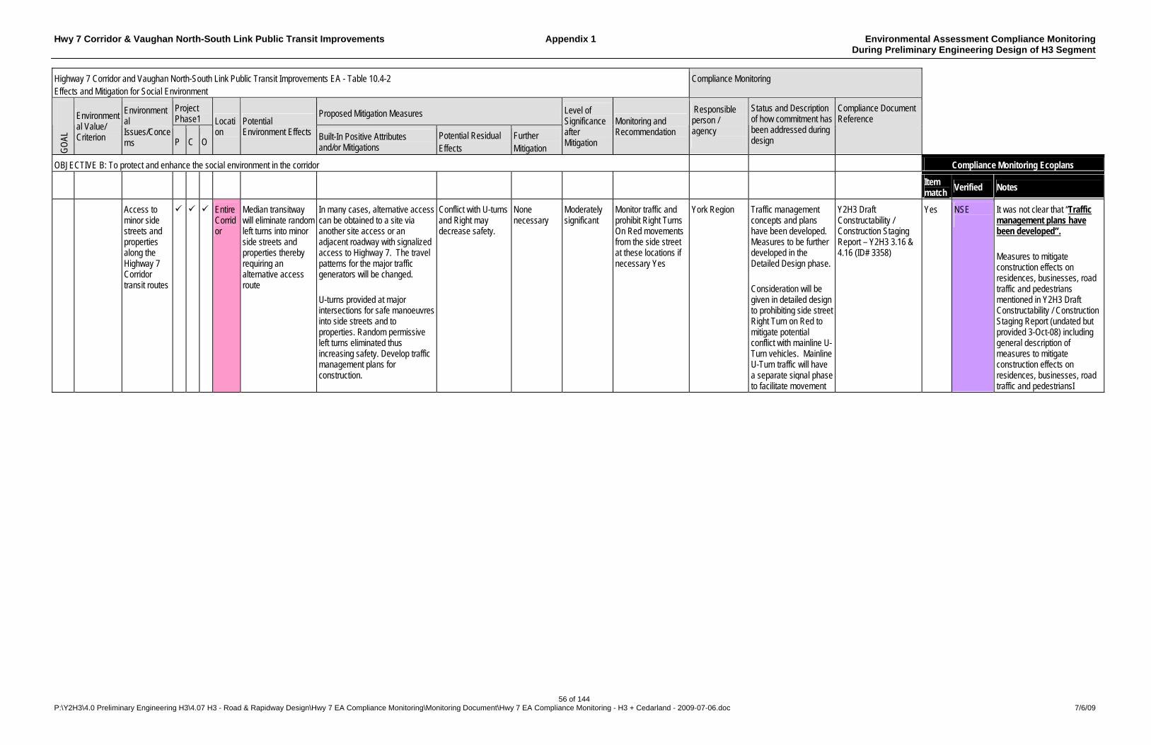
Hwy 7 Corridor & Vaughan North-South Link Public Transit Improvements Appendix 1 Environmental Assessment Compliance Monitoring During Preliminary Engineering Design of H3 Segment
56 of 144 P:\Y2H3\4.0 Preliminary Engineering H3\4.07 H3 - Road & Rapidway Design\Hwy 7 EA Compliance Monitoring\Monitoring Document\Hwy 7 EA Compliance Monitoring - H3 + Cedarland - 2009-07-06.doc 7/6/09
Highway 7 Corridor and Vaughan North-South Link Public Transit Improvements EA - Table 10.4-2 Effects and Mitigation for Social Environment
Compliance Monitoring
Project Phase1
Proposed Mitigation Measures
GO
AL
Environmental Value/ Criterion
Environmental Issues/Concerns P C O
Location
Potential Environment Effects Built-In Positive Attributes
and/or Mitigations Potential Residual Effects
Further Mitigation
Level of Significance after Mitigation
Monitoring and Recommendation
Responsible person / agency
Status and Description of how commitment has been addressed during design
Compliance Document Reference
OBJECTIVE B: To protect and enhance the social environment in the corridor Compliance Monitoring Ecoplans
Item match
Verified Notes
Access to minor side streets and properties along the Highway 7 Corridor transit routes
Entire Corridor
Median transitway will eliminate random left turns into minor side streets and properties thereby requiring an alternative access route
In many cases, alternative access can be obtained to a site via another site access or an adjacent roadway with signalized access to Highway 7. The travel patterns for the major traffic generators will be changed. U-turns provided at major intersections for safe manoeuvres into side streets and to properties. Random permissive left turns eliminated thus increasing safety. Develop traffic management plans for construction.
Conflict with U-turns and Right may decrease safety.
None necessary
Moderately significant
Monitor traffic and prohibit Right Turns On Red movements from the side street at these locations if necessary Yes
York Region Traffic management concepts and plans have been developed. Measures to be further developed in the Detailed Design phase. Consideration will be given in detailed design to prohibiting side street Right Turn on Red to mitigate potential conflict with mainline U-Turn vehicles. Mainline U-Turn traffic will have a separate signal phase to facilitate movement
Y2H3 Draft Constructability / Construction Staging Report – Y2H3 3.16 & 4.16 (ID# 3358)
Yes NSE
It was not clear that “Traffic management plans have been developed”. Measures to mitigate construction effects on residences, businesses, road traffic and pedestrians mentioned in Y2H3 Draft Constructability / Construction Staging Report (undated but provided 3-Oct-08) including general description of measures to mitigate construction effects on residences, businesses, road traffic and pedestriansI

Hwy 7 Corridor & Vaughan North-South Link Public Transit Improvements Appendix 1 Environmental Assessment Compliance Monitoring During Preliminary Engineering Design of H3 Segment
57 of 144 P:\Y2H3\4.0 Preliminary Engineering H3\4.07 H3 - Road & Rapidway Design\Hwy 7 EA Compliance Monitoring\Monitoring Document\Hwy 7 EA Compliance Monitoring - H3 + Cedarland - 2009-07-06.doc 7/6/09
Highway 7 Corridor and Vaughan North-South Link Public Transit Improvements EA - Table 10.4-2 Effects and Mitigation for Social Environment
Compliance Monitoring
Project Phase1
Proposed Mitigation Measures
GO
AL
Environmental Value/ Criterion
Environmental Issues/Concerns P C O
Location
Potential Environment Effects Built-In Positive Attributes
and/or Mitigations Potential Residual Effects
Further Mitigation
Level of Significance after Mitigation
Monitoring and Recommendation
Responsible person / agency
Status and Description of how commitment has been addressed during design
Compliance Document Reference
OBJECTIVE B: To protect and enhance the social environment in the corridor Compliance Monitoring Ecoplans
Item match
Verified Notes
B2 Cont’d
Maintain or improve road traffic and pedestrian circulation (cont’d)
U-turn movements and the corresponding side street right-turn-on-red (RTOR) movements
Highway 7/ Helen St.; Highway 7/ Town Centre Blvd.; Town Centre Blvd/ Cedarland Dr.; Kennedy Rd./ Avoca Dr.; Highway 7/ Robinson St./ St. Patrick School Entrance; Highway 7/ Grandview/ Galsworthy Dr.; Highway 7/ McCowan Rd.; Highway 7/ Laidlaw Blvd./ Conservation;
The permitted U-turn movements at these locations may cause conflicts with RTOR movements.
Follow-up monitoring should be undertaken to review the interaction between the U-turn movement and any opposing cross-street RTOR movement. A RTOR prohibition may need to be enacted to reduce conflicts at these intersections.
None Expected None Expected
Moderately Significant
Further monitoring should be undertaken to ensure the conflicts been reduced. Yes
York Region Consideration will be given in detailed design to prohibiting side street Right Turn on Red to mitigate potential conflict with mainline U-Turn vehicles. Mainline U-Turn traffic will have a separate signal phase to facilitate movement
Yes
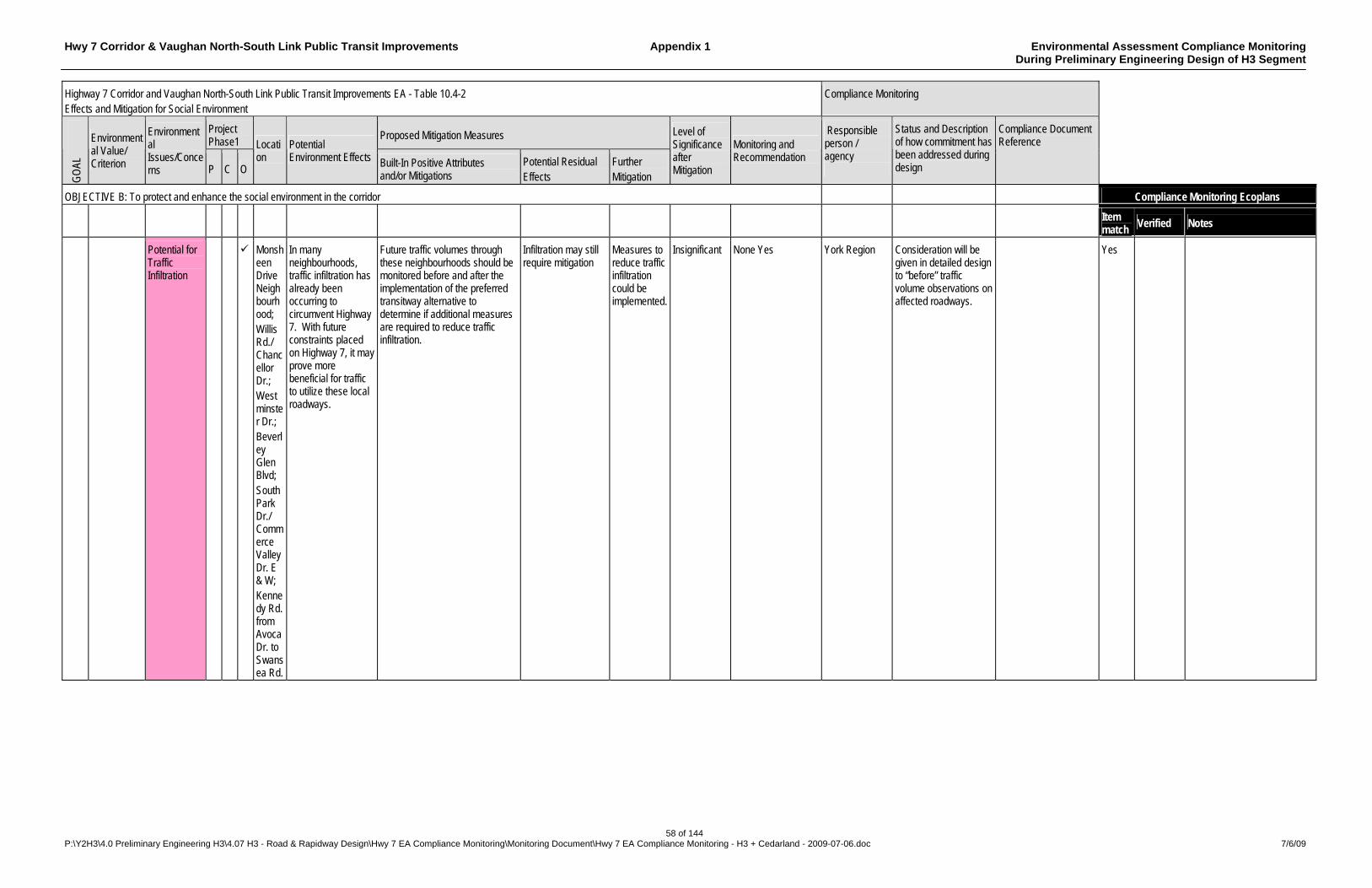
Hwy 7 Corridor & Vaughan North-South Link Public Transit Improvements Appendix 1 Environmental Assessment Compliance Monitoring During Preliminary Engineering Design of H3 Segment
58 of 144 P:\Y2H3\4.0 Preliminary Engineering H3\4.07 H3 - Road & Rapidway Design\Hwy 7 EA Compliance Monitoring\Monitoring Document\Hwy 7 EA Compliance Monitoring - H3 + Cedarland - 2009-07-06.doc 7/6/09
Highway 7 Corridor and Vaughan North-South Link Public Transit Improvements EA - Table 10.4-2 Effects and Mitigation for Social Environment
Compliance Monitoring
Project Phase1
Proposed Mitigation Measures
GO
AL
Environmental Value/ Criterion
Environmental Issues/Concerns P C O
Location
Potential Environment Effects Built-In Positive Attributes
and/or Mitigations Potential Residual Effects
Further Mitigation
Level of Significance after Mitigation
Monitoring and Recommendation
Responsible person / agency
Status and Description of how commitment has been addressed during design
Compliance Document Reference
OBJECTIVE B: To protect and enhance the social environment in the corridor Compliance Monitoring Ecoplans
Item match
Verified Notes
Potential for Traffic Infiltration
Monsheen Drive Neighbourhood; Willis Rd./ Chancellor Dr.; Westminster Dr.; Beverley Glen Blvd; South Park Dr./ Commerce Valley Dr. E & W; Kennedy Rd. from Avoca Dr. to Swansea Rd.
In many neighbourhoods, traffic infiltration has already been occurring to circumvent Highway 7. With future constraints placed on Highway 7, it may prove more beneficial for traffic to utilize these local roadways.
Future traffic volumes through these neighbourhoods should be monitored before and after the implementation of the preferred transitway alternative to determine if additional measures are required to reduce traffic infiltration.
Infiltration may still require mitigation
Measures to reduce traffic infiltration could be implemented.
Insignificant None Yes York Region Consideration will be given in detailed design to “before” traffic volume observations on affected roadways.
Yes
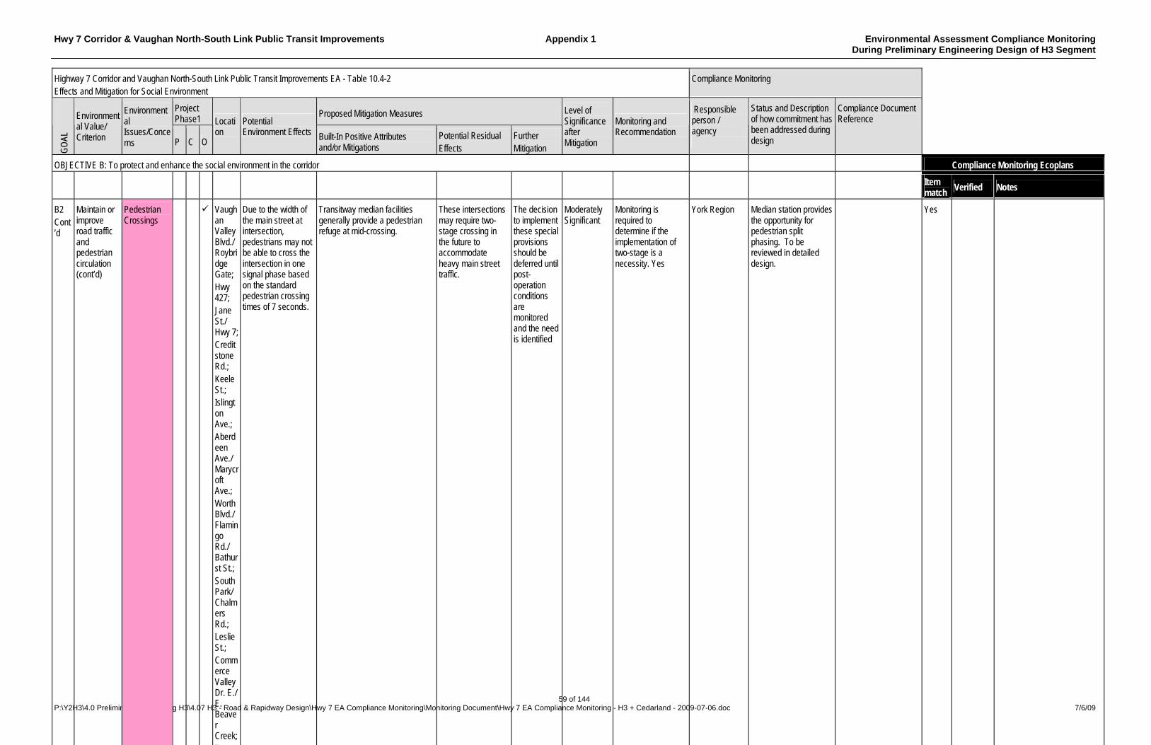
Hwy 7 Corridor & Vaughan North-South Link Public Transit Improvements Appendix 1 Environmental Assessment Compliance Monitoring During Preliminary Engineering Design of H3 Segment
59 of 144 P:\Y2H3\4.0 Preliminary Engineering H3\4.07 H3 - Road & Rapidway Design\Hwy 7 EA Compliance Monitoring\Monitoring Document\Hwy 7 EA Compliance Monitoring - H3 + Cedarland - 2009-07-06.doc 7/6/09
Highway 7 Corridor and Vaughan North-South Link Public Transit Improvements EA - Table 10.4-2 Effects and Mitigation for Social Environment
Compliance Monitoring
Project Phase1
Proposed Mitigation Measures
GO
AL
Environmental Value/ Criterion
Environmental Issues/Concerns P C O
Location
Potential Environment Effects Built-In Positive Attributes
and/or Mitigations Potential Residual Effects
Further Mitigation
Level of Significance after Mitigation
Monitoring and Recommendation
Responsible person / agency
Status and Description of how commitment has been addressed during design
Compliance Document Reference
OBJECTIVE B: To protect and enhance the social environment in the corridor Compliance Monitoring Ecoplans
Item match
Verified Notes
B2 Cont’d
Maintain or improve road traffic and pedestrian circulation (cont’d)
Pedestrian Crossings
Vaughan Valley Blvd./ Roybridge Gate; Hwy 427; Jane St./ Hwy 7; Creditstone Rd.; Keele St.; Islington Ave.; Aberdeen Ave./ Marycroft Ave.; Worth Blvd./ Flamingo Rd./ Bathurst St.; South Park/ Chalmers Rd.; Leslie St.; Commerce Valley Dr. E./ E. Beaver Creek; T
Due to the width of the main street at intersection, pedestrians may not be able to cross the intersection in one signal phase based on the standard pedestrian crossing times of 7 seconds.
Transitway median facilities generally provide a pedestrian refuge at mid-crossing.
These intersections may require two-stage crossing in the future to accommodate heavy main street traffic.
The decision to implement these special provisions should be deferred until post-operation conditions are monitored and the need is identified
Moderately Significant
Monitoring is required to determine if the implementation of two-stage is a necessity. Yes
York Region Median station provides the opportunity for pedestrian split phasing. To be reviewed in detailed design.
Yes
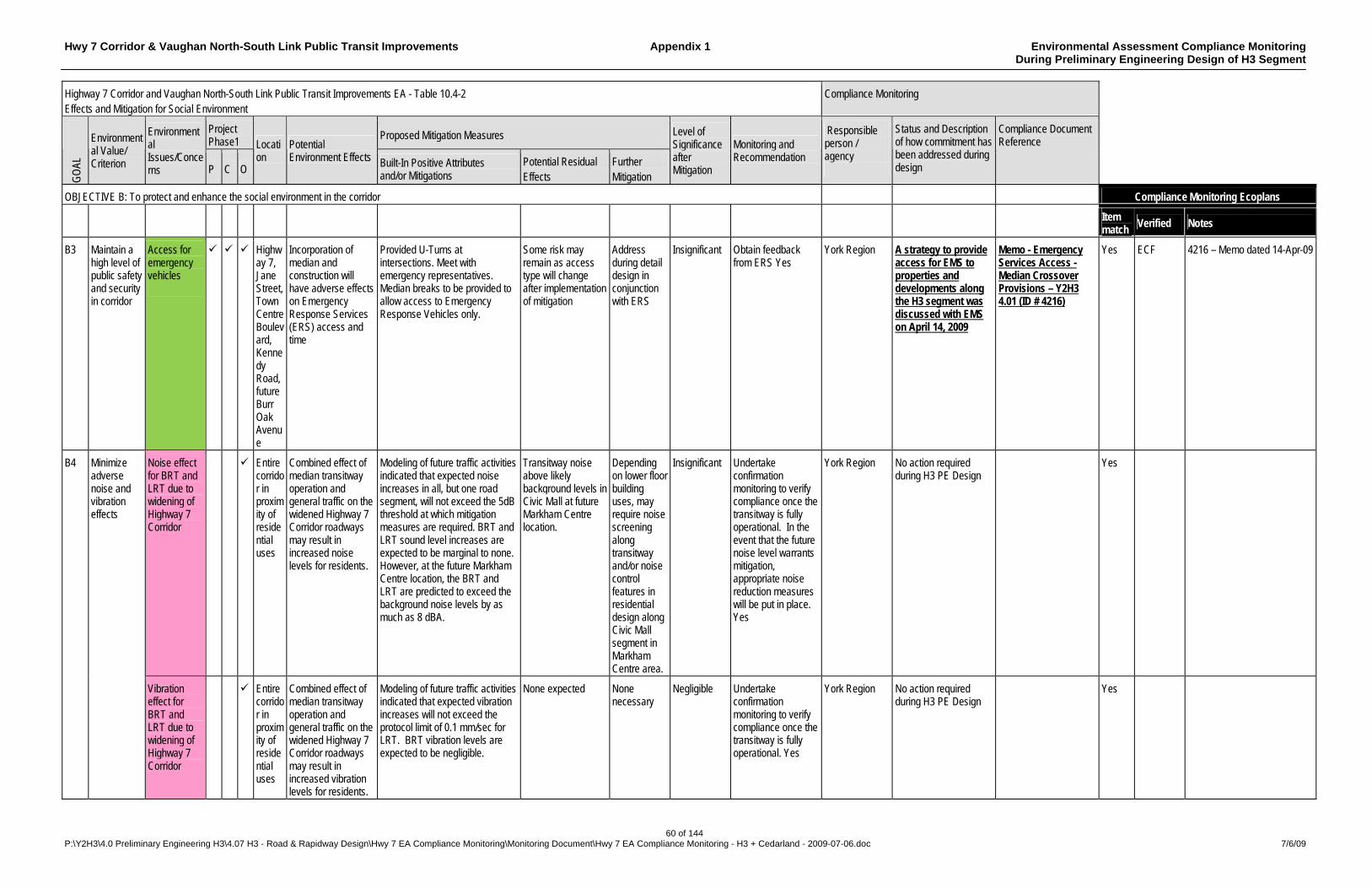
Hwy 7 Corridor & Vaughan North-South Link Public Transit Improvements Appendix 1 Environmental Assessment Compliance Monitoring During Preliminary Engineering Design of H3 Segment
60 of 144 P:\Y2H3\4.0 Preliminary Engineering H3\4.07 H3 - Road & Rapidway Design\Hwy 7 EA Compliance Monitoring\Monitoring Document\Hwy 7 EA Compliance Monitoring - H3 + Cedarland - 2009-07-06.doc 7/6/09
Highway 7 Corridor and Vaughan North-South Link Public Transit Improvements EA - Table 10.4-2 Effects and Mitigation for Social Environment
Compliance Monitoring
Project Phase1
Proposed Mitigation Measures
GO
AL
Environmental Value/ Criterion
Environmental Issues/Concerns P C O
Location
Potential Environment Effects Built-In Positive Attributes
and/or Mitigations Potential Residual Effects
Further Mitigation
Level of Significance after Mitigation
Monitoring and Recommendation
Responsible person / agency
Status and Description of how commitment has been addressed during design
Compliance Document Reference
OBJECTIVE B: To protect and enhance the social environment in the corridor Compliance Monitoring Ecoplans
Item match
Verified Notes
B3 Maintain a high level of public safety and security in corridor
Access for emergency vehicles
Highway 7, Jane Street, Town Centre Boulevard, Kennedy Road, future Burr Oak Avenue
Incorporation of median and construction will have adverse effects on Emergency Response Services (ERS) access and time
Provided U-Turns at intersections. Meet with emergency representatives. Median breaks to be provided to allow access to Emergency Response Vehicles only.
Some risk may remain as access type will change after implementation of mitigation
Address during detail design in conjunction with ERS
Insignificant Obtain feedback from ERS Yes
York Region A strategy to provide access for EMS to properties and developments along the H3 segment was discussed with EMS on April 14, 2009
Memo - Emergency Services Access - Median Crossover Provisions – Y2H3 4.01 (ID # 4216)
Yes ECF 4216 – Memo dated 14-Apr-09
Noise effect for BRT and LRT due to widening of Highway 7 Corridor
Entire corridor in proximity of residential uses
Combined effect of median transitway operation and general traffic on the widened Highway 7 Corridor roadways may result in increased noise levels for residents.
Modeling of future traffic activities indicated that expected noise increases in all, but one road segment, will not exceed the 5dB threshold at which mitigation measures are required. BRT and LRT sound level increases are expected to be marginal to none. However, at the future Markham Centre location, the BRT and LRT are predicted to exceed the background noise levels by as much as 8 dBA.
Transitway noise above likely background levels in Civic Mall at future Markham Centre location.
Depending on lower floor building uses, may require noise screening along transitway and/or noise control features in residential design along Civic Mall segment in Markham Centre area.
Insignificant Undertake confirmation monitoring to verify compliance once the transitway is fully operational. In the event that the future noise level warrants mitigation, appropriate noise reduction measures will be put in place. Yes
York Region No action required during H3 PE Design
Yes B4 Minimize adverse noise and vibration effects
Vibration effect for BRT and LRT due to widening of Highway 7 Corridor
Entire corridor in proximity of residential uses
Combined effect of median transitway operation and general traffic on the widened Highway 7 Corridor roadways may result in increased vibration levels for residents.
Modeling of future traffic activities indicated that expected vibration increases will not exceed the protocol limit of 0.1 mm/sec for LRT. BRT vibration levels are expected to be negligible.
None expected None necessary
Negligible Undertake confirmation monitoring to verify compliance once the transitway is fully operational. Yes
York Region No action required during H3 PE Design
Yes
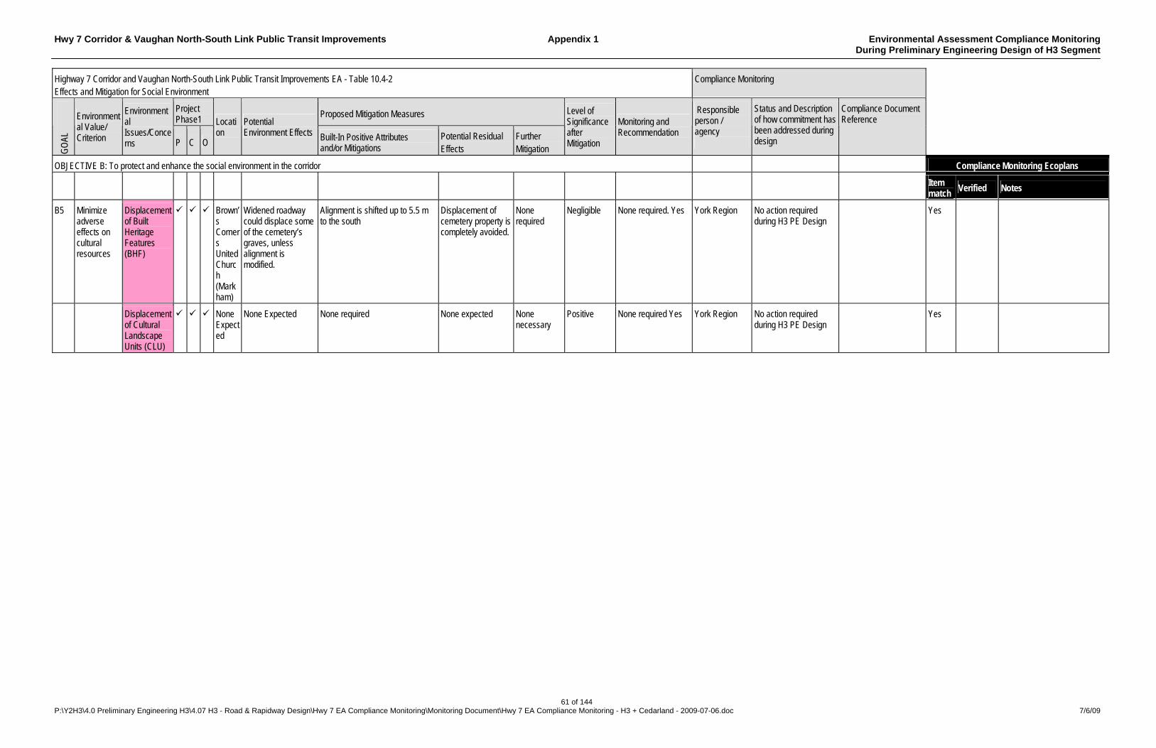
Hwy 7 Corridor & Vaughan North-South Link Public Transit Improvements Appendix 1 Environmental Assessment Compliance Monitoring During Preliminary Engineering Design of H3 Segment
61 of 144 P:\Y2H3\4.0 Preliminary Engineering H3\4.07 H3 - Road & Rapidway Design\Hwy 7 EA Compliance Monitoring\Monitoring Document\Hwy 7 EA Compliance Monitoring - H3 + Cedarland - 2009-07-06.doc 7/6/09
Highway 7 Corridor and Vaughan North-South Link Public Transit Improvements EA - Table 10.4-2 Effects and Mitigation for Social Environment
Compliance Monitoring
Project Phase1
Proposed Mitigation Measures
GO
AL
Environmental Value/ Criterion
Environmental Issues/Concerns P C O
Location
Potential Environment Effects Built-In Positive Attributes
and/or Mitigations Potential Residual Effects
Further Mitigation
Level of Significance after Mitigation
Monitoring and Recommendation
Responsible person / agency
Status and Description of how commitment has been addressed during design
Compliance Document Reference
OBJECTIVE B: To protect and enhance the social environment in the corridor Compliance Monitoring Ecoplans
Item match
Verified Notes
B5 Minimize adverse effects on cultural resources
Displacement of Built Heritage Features (BHF)
Brown’s Corners United Church (Markham)
Widened roadway could displace some of the cemetery’s graves, unless alignment is modified.
Alignment is shifted up to 5.5 m to the south
Displacement of cemetery property is completely avoided.
None required
Negligible None required. Yes York Region No action required during H3 PE Design
Yes
Displacement of Cultural Landscape Units (CLU)
None Expected
None Expected None required None expected None necessary
Positive None required Yes York Region No action required during H3 PE Design
Yes
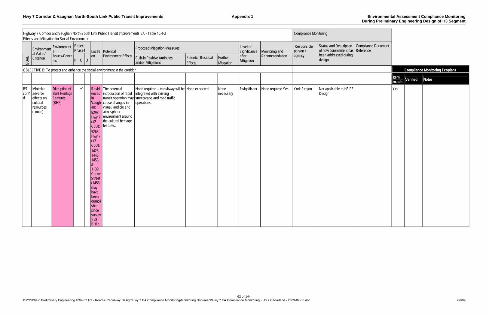
Hwy 7 Corridor & Vaughan North-South Link Public Transit Improvements Appendix 1 Environmental Assessment Compliance Monitoring During Preliminary Engineering Design of H3 Segment
62 of 144 P:\Y2H3\4.0 Preliminary Engineering H3\4.07 H3 - Road & Rapidway Design\Hwy 7 EA Compliance Monitoring\Monitoring Document\Hwy 7 EA Compliance Monitoring - H3 + Cedarland - 2009-07-06.doc 7/6/09
Highway 7 Corridor and Vaughan North-South Link Public Transit Improvements EA - Table 10.4-2 Effects and Mitigation for Social Environment
Compliance Monitoring
Project Phase1
Proposed Mitigation Measures
GO
AL
Environmental Value/ Criterion
Environmental Issues/Concerns P C O
Location
Potential Environment Effects Built-In Positive Attributes
and/or Mitigations Potential Residual Effects
Further Mitigation
Level of Significance after Mitigation
Monitoring and Recommendation
Responsible person / agency
Status and Description of how commitment has been addressed during design
Compliance Document Reference
OBJECTIVE B: To protect and enhance the social environment in the corridor Compliance Monitoring Ecoplans
Item match
Verified Notes
B5 cont’d
Minimize adverse effects on cultural resources (cont’d)
Disruption of Built Heritage Features (BHF)
Residences in Vaughan: 5298 Hwy 7 (#2 CLU); 5263 Hwy 7 (#2 CLU); 1423, 1445, 1453 & 1139 Centre Street (1453 may have been demolished since survey)(#8 BHF;
The potential introduction of rapid transit operation may cause changes in visual, audible and atmospheric environment around the cultural heritage features.
None required – transitway will be integrated with existing streetscape and road traffic operations.
None expected None necessary
Insignificant None required Yes York Region Not applicable to H3 PE Design
Yes
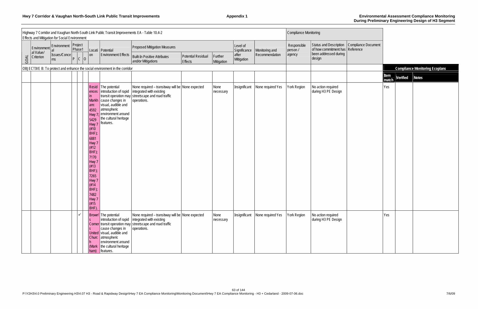
Hwy 7 Corridor & Vaughan North-South Link Public Transit Improvements Appendix 1 Environmental Assessment Compliance Monitoring During Preliminary Engineering Design of H3 Segment
63 of 144 P:\Y2H3\4.0 Preliminary Engineering H3\4.07 H3 - Road & Rapidway Design\Hwy 7 EA Compliance Monitoring\Monitoring Document\Hwy 7 EA Compliance Monitoring - H3 + Cedarland - 2009-07-06.doc 7/6/09
Highway 7 Corridor and Vaughan North-South Link Public Transit Improvements EA - Table 10.4-2 Effects and Mitigation for Social Environment
Compliance Monitoring
Project Phase1
Proposed Mitigation Measures
GO
AL
Environmental Value/ Criterion
Environmental Issues/Concerns P C O
Location
Potential Environment Effects Built-In Positive Attributes
and/or Mitigations Potential Residual Effects
Further Mitigation
Level of Significance after Mitigation
Monitoring and Recommendation
Responsible person / agency
Status and Description of how commitment has been addressed during design
Compliance Document Reference
OBJECTIVE B: To protect and enhance the social environment in the corridor Compliance Monitoring Ecoplans
Item match
Verified Notes
Residences in Markham: 4592 Hwy 7; 5429 Hwy 7 (#10 BHF); 6881 Hwy 7 (#12 BHF); 7170 Hwy 7 (#13 BHF); 7265 Hwy 7 (#14 BHF); 7482 Hwy 7 (#15 BHF).
The potential introduction of rapid transit operation may cause changes in visual, audible and atmospheric environment around the cultural heritage features.
None required – transitway will be integrated with existing streetscape and road traffic operations.
None expected None necessary
Insignificant None required Yes York Region No action required during H3 PE Design
Yes
Brown’s Corners United Church (Markham)
The potential introduction of rapid transit operation may cause changes in visual, audible and atmospheric environment around the cultural heritage features.
None required – transitway will be integrated with existing streetscape and road traffic operations.
None expected None necessary
Insignificant None required Yes York Region No action required during H3 PE Design
Yes
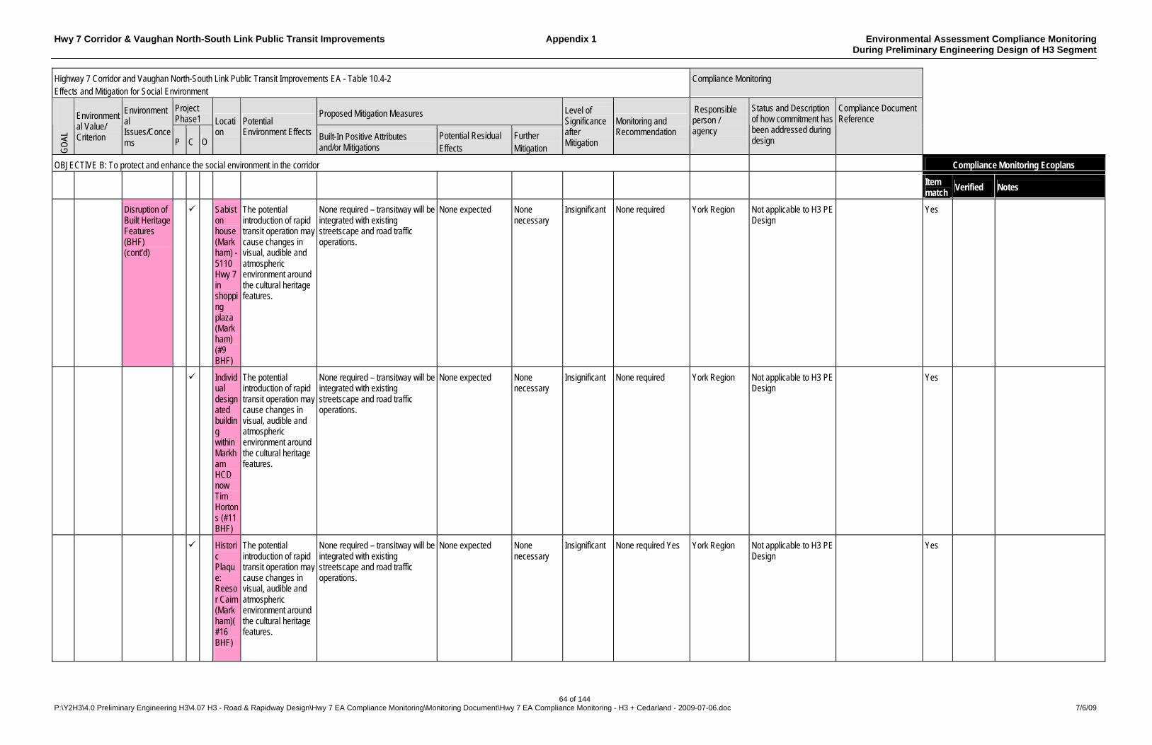
Hwy 7 Corridor & Vaughan North-South Link Public Transit Improvements Appendix 1 Environmental Assessment Compliance Monitoring During Preliminary Engineering Design of H3 Segment
64 of 144 P:\Y2H3\4.0 Preliminary Engineering H3\4.07 H3 - Road & Rapidway Design\Hwy 7 EA Compliance Monitoring\Monitoring Document\Hwy 7 EA Compliance Monitoring - H3 + Cedarland - 2009-07-06.doc 7/6/09
Highway 7 Corridor and Vaughan North-South Link Public Transit Improvements EA - Table 10.4-2 Effects and Mitigation for Social Environment
Compliance Monitoring
Project Phase1
Proposed Mitigation Measures
GO
AL
Environmental Value/ Criterion
Environmental Issues/Concerns P C O
Location
Potential Environment Effects Built-In Positive Attributes
and/or Mitigations Potential Residual Effects
Further Mitigation
Level of Significance after Mitigation
Monitoring and Recommendation
Responsible person / agency
Status and Description of how commitment has been addressed during design
Compliance Document Reference
OBJECTIVE B: To protect and enhance the social environment in the corridor Compliance Monitoring Ecoplans
Item match
Verified Notes
Disruption of Built Heritage Features (BHF) (cont’d)
Sabiston house (Markham) - 5110 Hwy 7 in shopping plaza (Markham) (#9 BHF)
The potential introduction of rapid transit operation may cause changes in visual, audible and atmospheric environment around the cultural heritage features.
None required – transitway will be integrated with existing streetscape and road traffic operations.
None expected None necessary
Insignificant None required York Region Not applicable to H3 PE Design
Yes
Individual designated building within Markham HCD now Tim Hortons (#11 BHF)
The potential introduction of rapid transit operation may cause changes in visual, audible and atmospheric environment around the cultural heritage features.
None required – transitway will be integrated with existing streetscape and road traffic operations.
None expected None necessary
Insignificant None required York Region Not applicable to H3 PE Design
Yes
Historic Plaque: Reesor Cairn (Markham)(#16 BHF)
The potential introduction of rapid transit operation may cause changes in visual, audible and atmospheric environment around the cultural heritage features.
None required – transitway will be integrated with existing streetscape and road traffic operations.
None expected None necessary
Insignificant None required Yes York Region Not applicable to H3 PE Design
Yes
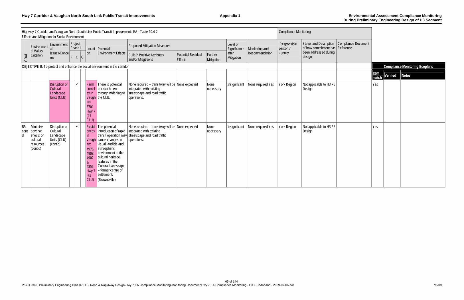
Hwy 7 Corridor & Vaughan North-South Link Public Transit Improvements Appendix 1 Environmental Assessment Compliance Monitoring During Preliminary Engineering Design of H3 Segment
65 of 144 P:\Y2H3\4.0 Preliminary Engineering H3\4.07 H3 - Road & Rapidway Design\Hwy 7 EA Compliance Monitoring\Monitoring Document\Hwy 7 EA Compliance Monitoring - H3 + Cedarland - 2009-07-06.doc 7/6/09
Highway 7 Corridor and Vaughan North-South Link Public Transit Improvements EA - Table 10.4-2 Effects and Mitigation for Social Environment
Compliance Monitoring
Project Phase1
Proposed Mitigation Measures
GO
AL
Environmental Value/ Criterion
Environmental Issues/Concerns P C O
Location
Potential Environment Effects Built-In Positive Attributes
and/or Mitigations Potential Residual Effects
Further Mitigation
Level of Significance after Mitigation
Monitoring and Recommendation
Responsible person / agency
Status and Description of how commitment has been addressed during design
Compliance Document Reference
OBJECTIVE B: To protect and enhance the social environment in the corridor Compliance Monitoring Ecoplans
Item match
Verified Notes
Disruption of Cultural Landscape Units (CLU)
Farm complex in Vaughan: 6701 Hwy 7 (#1 CLU)
There is potential encroachment through widening to the CLU.
None required – transitway will be integrated with existing streetscape and road traffic operations.
None expected None necessary
Insignificant None required Yes York Region Not applicable to H3 PE Design
Yes
B5 cont’d
Minimize adverse effects on cultural resources (cont’d)
Disruption of Cultural Landscape Units (CLU) (cont’d)
Residences in Vaughan: 4976, 4908, 4902 & 4855 Hwy 7 (#2 CLU)
The potential introduction of rapid transit operation may cause changes in visual, audible and atmospheric environment to the cultural heritage features in the Cultural Landscape – former centre of settlement. (Brownsville)
None required – transitway will be integrated with existing streetscape and road traffic operations.
None expected None necessary
Insignificant None required Yes York Region Not applicable to H3 PE Design
Yes

Hwy 7 Corridor & Vaughan North-South Link Public Transit Improvements Appendix 1 Environmental Assessment Compliance Monitoring During Preliminary Engineering Design of H3 Segment
66 of 144 P:\Y2H3\4.0 Preliminary Engineering H3\4.07 H3 - Road & Rapidway Design\Hwy 7 EA Compliance Monitoring\Monitoring Document\Hwy 7 EA Compliance Monitoring - H3 + Cedarland - 2009-07-06.doc 7/6/09
Highway 7 Corridor and Vaughan North-South Link Public Transit Improvements EA - Table 10.4-2 Effects and Mitigation for Social Environment
Compliance Monitoring
Project Phase1
Proposed Mitigation Measures
GO
AL
Environmental Value/ Criterion
Environmental Issues/Concerns P C O
Location
Potential Environment Effects Built-In Positive Attributes
and/or Mitigations Potential Residual Effects
Further Mitigation
Level of Significance after Mitigation
Monitoring and Recommendation
Responsible person / agency
Status and Description of how commitment has been addressed during design
Compliance Document Reference
OBJECTIVE B: To protect and enhance the social environment in the corridor Compliance Monitoring Ecoplans
Item match
Verified Notes
Residences in Vaughan: 2060, 2063, 1985 & 1929 Hwy 7 (#3 – #6 BHF) Southeast of Hwy 7 & GO Bradford (no street address)(#7 BHF) GO Bradford railway overpass
The potential introduction of rapid transit operation may cause changes in visual, audible and atmospheric environment around the cultural heritage features.
None required – transitway will be integrated with existing streetscape and road traffic operations.
None expected None necessary
Insignificant None required Yes York Region Not applicable to H3 PE Design
Yes
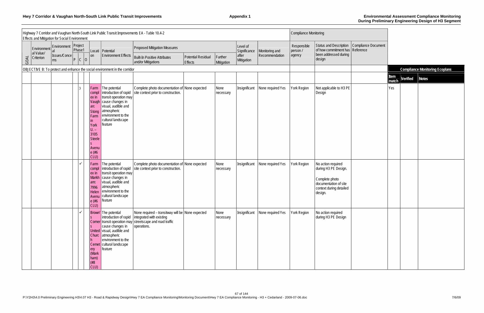
Hwy 7 Corridor & Vaughan North-South Link Public Transit Improvements Appendix 1 Environmental Assessment Compliance Monitoring During Preliminary Engineering Design of H3 Segment
67 of 144 P:\Y2H3\4.0 Preliminary Engineering H3\4.07 H3 - Road & Rapidway Design\Hwy 7 EA Compliance Monitoring\Monitoring Document\Hwy 7 EA Compliance Monitoring - H3 + Cedarland - 2009-07-06.doc 7/6/09
Highway 7 Corridor and Vaughan North-South Link Public Transit Improvements EA - Table 10.4-2 Effects and Mitigation for Social Environment
Compliance Monitoring
Project Phase1
Proposed Mitigation Measures
GO
AL
Environmental Value/ Criterion
Environmental Issues/Concerns P C O
Location
Potential Environment Effects Built-In Positive Attributes
and/or Mitigations Potential Residual Effects
Further Mitigation
Level of Significance after Mitigation
Monitoring and Recommendation
Responsible person / agency
Status and Description of how commitment has been addressed during design
Compliance Document Reference
OBJECTIVE B: To protect and enhance the social environment in the corridor Compliance Monitoring Ecoplans
Item match
Verified Notes
Farm complex in Vaughan: Stong Farm in York U. – 3105 Steeles Avenue (#6 CLU)
The potential introduction of rapid transit operation may cause changes in visual, audible and atmospheric environment to the cultural landscape feature
Complete photo documentation of site context prior to construction.
None expected None necessary
Insignificant None required Yes York Region Not applicable to H3 PE Design
Yes
Farm complex in Markham: 7996 Helen Avenue (#6 CLU)
The potential introduction of rapid transit operation may cause changes in visual, audible and atmospheric environment to the cultural landscape feature
Complete photo documentation of site context prior to construction.
None expected None necessary
Insignificant None required Yes York Region No action required during H3 PE Design. Complete photo documentation of site context during detailed design.
Brown’s Corners United Church Cemetery (Markham) (#8 CLU)
The potential introduction of rapid transit operation may cause changes in visual, audible and atmospheric environment to the cultural landscape feature
None required – transitway will be integrated with existing streetscape and road traffic operations.
None expected None necessary
Insignificant None required Yes York Region No action required during H3 PE Design
Hwy 7 Corridor & Vaughan North-South Link Public Transit Improvements Appendix 1 Environmental Assessment Compliance Monitoring During Preliminary Engineering Design of H3 Segment
68 of 144 P:\Y2H3\4.0 Preliminary Engineering H3\4.07 H3 - Road & Rapidway Design\Hwy 7 EA Compliance Monitoring\Monitoring Document\Hwy 7 EA Compliance Monitoring - H3 + Cedarland - 2009-07-06.doc 7/6/09
Highway 7 Corridor and Vaughan North-South Link Public Transit Improvements EA - Table 10.4-2 Effects and Mitigation for Social Environment
Compliance Monitoring
Project Phase1
Proposed Mitigation Measures
GO
AL
Environmental Value/ Criterion
Environmental Issues/Concerns P C O
Location
Potential Environment Effects Built-In Positive Attributes
and/or Mitigations Potential Residual Effects
Further Mitigation
Level of Significance after Mitigation
Monitoring and Recommendation
Responsible person / agency
Status and Description of how commitment has been addressed during design
Compliance Document Reference
OBJECTIVE B: To protect and enhance the social environment in the corridor Compliance Monitoring Ecoplans
Item match
Verified Notes
Centre of settlement: Markham Village Heritage Conser-vation District designated under Part V OHA (#11 CLU)
The potential introduction of rapid transit operation may cause changes in visual, audible and atmospheric environment to the cultural landscape feature
None required – transitway will be integrated with existing streetscape and road traffic operations.
None expected None necessary
Insignificant None required Yes York Region No action required during H3 PE Design
Elmwood Cemetery (Markham)
The potential introduction of rapid transit operation may cause changes in visual, audible and atmospheric environment to the cultural landscape feature
Transitway will operate in mixed traffic to avoid widening adjacent to the cemetery.
None expected None necessary
Insignificant None required Yes York Region Not applicable to H3 PE Design
St. Andrews Cemetery (Markham)
The potential introduction of rapid transit operation may cause changes in visual, audible and atmospheric environment to the cultural landscape feature
Transitway will operate in mixed traffic to avoid widening adjacent to the cemetery.
None expected None necessary
Insignificant None required Yes York Region Not applicable to H3 PE Design
Hwy 7 Corridor & Vaughan North-South Link Public Transit Improvements Appendix 1 Environmental Assessment Compliance Monitoring During Preliminary Engineering Design of H3 Segment
69 of 144 P:\Y2H3\4.0 Preliminary Engineering H3\4.07 H3 - Road & Rapidway Design\Hwy 7 EA Compliance Monitoring\Monitoring Document\Hwy 7 EA Compliance Monitoring - H3 + Cedarland - 2009-07-06.doc 7/6/09
Highway 7 Corridor and Vaughan North-South Link Public Transit Improvements EA - Table 10.4-2 Effects and Mitigation for Social Environment
Compliance Monitoring
Project Phase1
Proposed Mitigation Measures
GO
AL
Environmental Value/ Criterion
Environmental Issues/Concerns P C O
Location
Potential Environment Effects Built-In Positive Attributes
and/or Mitigations Potential Residual Effects
Further Mitigation
Level of Significance after Mitigation
Monitoring and Recommendation
Responsible person / agency
Status and Description of how commitment has been addressed during design
Compliance Document Reference
OBJECTIVE B: To protect and enhance the social environment in the corridor Compliance Monitoring Ecoplans
Item match
Verified Notes
B5 cont’d
Minimize adverse effects on cultural resources (cont’d)
Disruption of Cultural Landscape Units (CLU) (cont’d)
Farm complex in Markham: 6937 Hwy 7 (#12 CLU) 7323 Hwy. 7 (Likely demolished)(#13 CLU)
The potential introduction of rapid transit operation may cause changes in visual, audible and atmospheric environment to the cultural landscape feature
None required – transitway will be integrated with existing streetscape and road traffic operations.
None expected None necessary
Insignificant None required Yes York Region Not applicable to H3 PE Design
Locust Hill – historical centre of settlement (#15 CLU)
The potential introduction of rapid transit operation may cause changes in visual, audible and atmospheric environment to the cultural landscape feature
Transitway development will not extend eastward beyond Reesor Road. Any rapid transit through Locust Hill to Pickering will operate in mixed traffic.
None expected None necessary
Insignificant None required Yes York Region Not applicable to H3 PE Design
At grade historic railway corridor: CP Havelock rail line (#16 CLU)
The potential introduction of rapid transit operation may cause changes in visual, audible and atmospheric environment to the cultural landscape feature
Transitway development will not extend eastward beyond Reesor Road. Any rapid transit through Locust Hill to Pickering will operate in mixed traffic.
None expected None necessary
Insignificant None required Yes York Region Not applicable to H3 PE Design

Hwy 7 Corridor & Vaughan North-South Link Public Transit Improvements Appendix 1 Environmental Assessment Compliance Monitoring During Preliminary Engineering Design of H3 Segment
70 of 144 P:\Y2H3\4.0 Preliminary Engineering H3\4.07 H3 - Road & Rapidway Design\Hwy 7 EA Compliance Monitoring\Monitoring Document\Hwy 7 EA Compliance Monitoring - H3 + Cedarland - 2009-07-06.doc 7/6/09
Highway 7 Corridor and Vaughan North-South Link Public Transit Improvements EA - Table 10.4-2 Effects and Mitigation for Social Environment
Compliance Monitoring
Project Phase1
Proposed Mitigation Measures
GO
AL
Environmental Value/ Criterion
Environmental Issues/Concerns P C O
Location
Potential Environment Effects Built-In Positive Attributes
and/or Mitigations Potential Residual Effects
Further Mitigation
Level of Significance after Mitigation
Monitoring and Recommendation
Responsible person / agency
Status and Description of how commitment has been addressed during design
Compliance Document Reference
OBJECTIVE B: To protect and enhance the social environment in the corridor Compliance Monitoring Ecoplans
Item match
Verified Notes
Roadscape: Reesor Road landscape north side. (#14 CLU)
The potential introduction of rapid transit operation may cause changes in visual, audible and atmospheric environment to the cultural landscape feature
None required – transitway will be integrated with existing streetscape and road traffic operations.
None expected None necessary
Insignificant None required Yes York Region Not applicable to H3 PE Design
Hwy 7 Corridor & Vaughan North-South Link Public Transit Improvements Appendix 1 Environmental Assessment Compliance Monitoring During Preliminary Engineering Design of H3 Segment
71 of 144 P:\Y2H3\4.0 Preliminary Engineering H3\4.07 H3 - Road & Rapidway Design\Hwy 7 EA Compliance Monitoring\Monitoring Document\Hwy 7 EA Compliance Monitoring - H3 + Cedarland - 2009-07-06.doc 7/6/09
Highway 7 Corridor and Vaughan North-South Link Public Transit Improvements EA - Table 10.4-2 Effects and Mitigation for Social Environment
Compliance Monitoring
Project Phase1
Proposed Mitigation Measures
GO
AL
Environmental Value/ Criterion
Environmental Issues/Concerns P C O
Location
Potential Environment Effects Built-In Positive Attributes
and/or Mitigations Potential Residual Effects
Further Mitigation
Level of Significance after Mitigation
Monitoring and Recommendation
Responsible person / agency
Status and Description of how commitment has been addressed during design
Compliance Document Reference
OBJECTIVE B: To protect and enhance the social environment in the corridor Compliance Monitoring Ecoplans
Item match
Verified Notes
Possible impacts to areas with potential for identification of archaeological sites
Entire Corridor
There is potential for identification of archaeological sites within the project impact area.
Stage 1 Archaeological Assessment has been conducted. Stage 2 Archaeological Assessment will be performed in detailed design: field survey in accordance with Ministry of Culture Stage 1-3 Archaeological Assessment Technical Guidelines to identify any sites that may be present within the proposed impact area. If areas of further archaeological concern are identified during Stage 2 assessment, such areas must be avoided until any additional work required by the Ministry of Culture has been completed. Mitigation options, including avoidance, protection, or salvage excavation must be determined on a site-by-site basis. If no potentially significant archaeological sites are identified during Stage 2, it will be recommended to the Ministry of Culture that the areas assessed be considered free of further archaeological concern.
Archaeological sites may be identified during the course of Stage 2 Archaeological Assessment. In the event that deeply buried archaeological remains are encountered during construction activities, the office of the Regulatory and Operations Group, Ministry of Culture should be notified immediately. In the event that human remains are encountered during construction, both the Ministry of Culture and the Registrar or Deputy Registrar of the Cemeteries Regulation Unit, Ministry of Consumer and Commercial Relations should be notified immediately.
Needs for further mitigation, possibly including Stage 3 Archaeological Assessment (test excavation) and Stage 4 Archaeological Assessment (further mitigative work, including mitigative excavation), must be determined following Stage 2 Archaeological Assessment, if archaeological resources are identified during survey.
Negligible for stage 1 Archaeological Assessment
No requirement for monitoring has been identified as a result of Stage 1 Archaeological Assessment. Monitoring may be required, depending on the result of Stage 2 Archaeological Assessment. Yes
York Region A Stage 2 Archaeological Assessment will be undertaken during the detail design phase.
Hwy 7 Corridor & Vaughan North-South Link Public Transit Improvements Appendix 1 Environmental Assessment Compliance Monitoring During Preliminary Engineering Design of H3 Segment
72 of 144 P:\Y2H3\4.0 Preliminary Engineering H3\4.07 H3 - Road & Rapidway Design\Hwy 7 EA Compliance Monitoring\Monitoring Document\Hwy 7 EA Compliance Monitoring - H3 + Cedarland - 2009-07-06.doc 7/6/09
Highway 7 Corridor and Vaughan North-South Link Public Transit Improvements EA - Table 10.4-2 Effects and Mitigation for Social Environment
Compliance Monitoring
Project Phase1
Proposed Mitigation Measures
GO
AL
Environmental Value/ Criterion
Environmental Issues/Concerns P C O
Location
Potential Environment Effects Built-In Positive Attributes
and/or Mitigations Potential Residual Effects
Further Mitigation
Level of Significance after Mitigation
Monitoring and Recommendation
Responsible person / agency
Status and Description of how commitment has been addressed during design
Compliance Document Reference
OBJECTIVE B: To protect and enhance the social environment in the corridor Compliance Monitoring Ecoplans
Item match
Verified Notes
B6 Minimize disruption of community vistas and adverse effects on street and neighbourhood aesthetics
Visual Effects
Entire Corridor
Introduction of transit may reduce visual aesthetics of road
Introduction of a comprehensive landscaping and streetscaping plan for the corridor.
Narrow sections of ROW where property cannot be acquired may limit incorporation of streetscaping
Significant Monitor redevelopment and acquire property through redevelopment applications
York Region The DBCR incorporates streetscaping recommendations: Streetscape Design Guidelines (Section 4.10), General Guidelines (Section 4.11), etc.
Highway 7 Rapidway - Section H3 – Yonge St to Kennedy Rd – Design Basis & Criteria Ver. 1.2 – Y2H3 4.02 (ID# 3551) and Enterprise / Civic Mall Supplement - ESP 3.02 (ID# 4040)
yes ECF 4040 -Highway 7 Rapidway - Section H3 – Yonge St to Kennedy Rd – Design Basis & Criteria Ver. 1.2 includes Section 4.10 and 4.11 Streetscape design guidelines plus several references to pedestrian and roadside safety
Visual Effects Hwy 404 interchange
If necessary in the future, achieving a dedicated transitway through the interchange by adopting an elevated solution, could have an adverse effect on vistas in the area.
Initially, the option of lengthening the span of the existing interchange bridges will be analyzed and only if found impractical under traffic operations, will an elevated solution be developed. This design can be made visually acceptable given the surrounding highway interchange environment and the remoteness of adjacent land uses from which vistas may be degraded.
The overall height of the interchange works would be increased to that of the neighbouring Highway 407 interchange.
None Insignificant if span lengthening is adopted. Moderately significant if elevated design is required.
Monitor the level of traffic congestion affecting the reliability of the preferred mixed traffic operation to assess the effectiveness of the planned new Hwy 404 road overpass north of the interchange. Yes
York Region Preliminary engineering design does not recommend implementation of elevated solutions at this time. A single lane Rapidway with transit signal is proposed for the Highway 404 crossing.
Traffic Impact Analysis (H3) Highway 7 – Yonge Street Connector to South Town Centre Boulevard - Y2H3 4.12 (ID# 3354) Constrained Areas Report - Highway 404 Crossing – Y2H3 4.10 (ID# 3881)
Yes ECF 3354 VIVA Next TASK 4.12: TRAFFIC IMPACT ANALYSIS (H3) HIGHWAY 7 - YONGE STREET CONNECTOR RAMP TO SOUTH TOWN CENTRE BOULEVARD REPORT (SEPTEMBER 2008 3881 Constrained Areas Report - Highway 404 Crossing (15-Oct-08)
B6 Cont’d
Minimize disruption of community vistas and adverse effects on street and neighbourhood aesthetics (cont’d)
Landscaping
Entire Corridor
Landscaping species may not survive in winter months
Choose appropriate species for both winter and other months to maintain greenery throughout corridor. Place landscaping in planters and incorporate buried irrigation systems.
Species may still not survive
Change species, irrigation patterns, etc
Insignificant Monitor health of landscaping continuously Yes
York Region H3 PE Design addresses sustainability of landscape features and a greater degree of greening – e.g. Section 4.21 of the DBCR
Highway 7 Rapidway - Section H3 – Yonge St to Kennedy Rd – Design Basis & Criteria Ver. 1.2 – Y2H3 4.02 (ID# 3551) and Enterprise / Civic Mall Supplement - ESP 3.02 (ID# 4040)
ECF 4040 -Highway 7 Rapidway - Section H3 – Yonge St to Kennedy Rd – Design Basis & Criteria Ver. 1.2 includes Section 4.10 and 4.11 Streetscape design guidelines plus several references to pedestrian and roadside safety
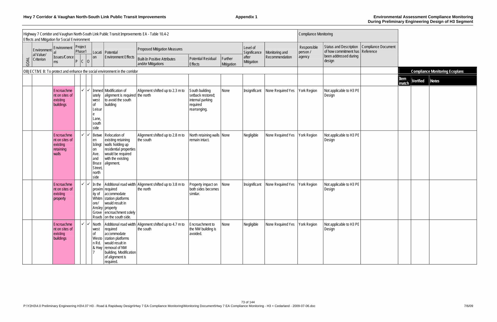
Hwy 7 Corridor & Vaughan North-South Link Public Transit Improvements Appendix 1 Environmental Assessment Compliance Monitoring During Preliminary Engineering Design of H3 Segment
73 of 144 P:\Y2H3\4.0 Preliminary Engineering H3\4.07 H3 - Road & Rapidway Design\Hwy 7 EA Compliance Monitoring\Monitoring Document\Hwy 7 EA Compliance Monitoring - H3 + Cedarland - 2009-07-06.doc 7/6/09
Highway 7 Corridor and Vaughan North-South Link Public Transit Improvements EA - Table 10.4-2 Effects and Mitigation for Social Environment
Compliance Monitoring
Project Phase1
Proposed Mitigation Measures
GO
AL
Environmental Value/ Criterion
Environmental Issues/Concerns P C O
Location
Potential Environment Effects Built-In Positive Attributes
and/or Mitigations Potential Residual Effects
Further Mitigation
Level of Significance after Mitigation
Monitoring and Recommendation
Responsible person / agency
Status and Description of how commitment has been addressed during design
Compliance Document Reference
OBJECTIVE B: To protect and enhance the social environment in the corridor Compliance Monitoring Ecoplans
Item match
Verified Notes
Encroachment on sites of existing buildings
Immediately west of Leisure Lane, south side
Modification of alignment is required to avoid the south building
Alignment shifted up to 2.3 m to the north
South building setback restored; internal parking required rearranging.
None Insignificant None Required Yes York Region Not applicable to H3 PE Design
Encroachment on sites of existing retaining walls
Between Islington Ave. and Bruce Street, north side
Relocation of existing retaining walls holding up residential properties would be required with the existing alignment.
Alignment shifted up to 2.8 m to the south
North retaining walls remain intact.
None Negligible None Required Yes York Region Not applicable to H3 PE Design
Encroachment on sites of existing property
In the proximity of Whitmore/ Ansley Grove Roads
Additional road width required accommodate station platforms would result in property encroachment solely on the south side.
Alignment shifted up to 3.8 m to the north
Property impact on both sides becomes similar.
None Insignificant None Required Yes York Region Not applicable to H3 PE Design
Encroachment on sites of existing buildings
Northwest of Weston Rd. & Hwy 7
Additional road width required accommodate station platforms would result in removal of NW building. Modification of alignment is required.
Alignment shifted up to 4.7 m to the south
Encroachment to the NW building is avoided.
None Negligible None Required Yes York Region Not applicable to H3 PE Design
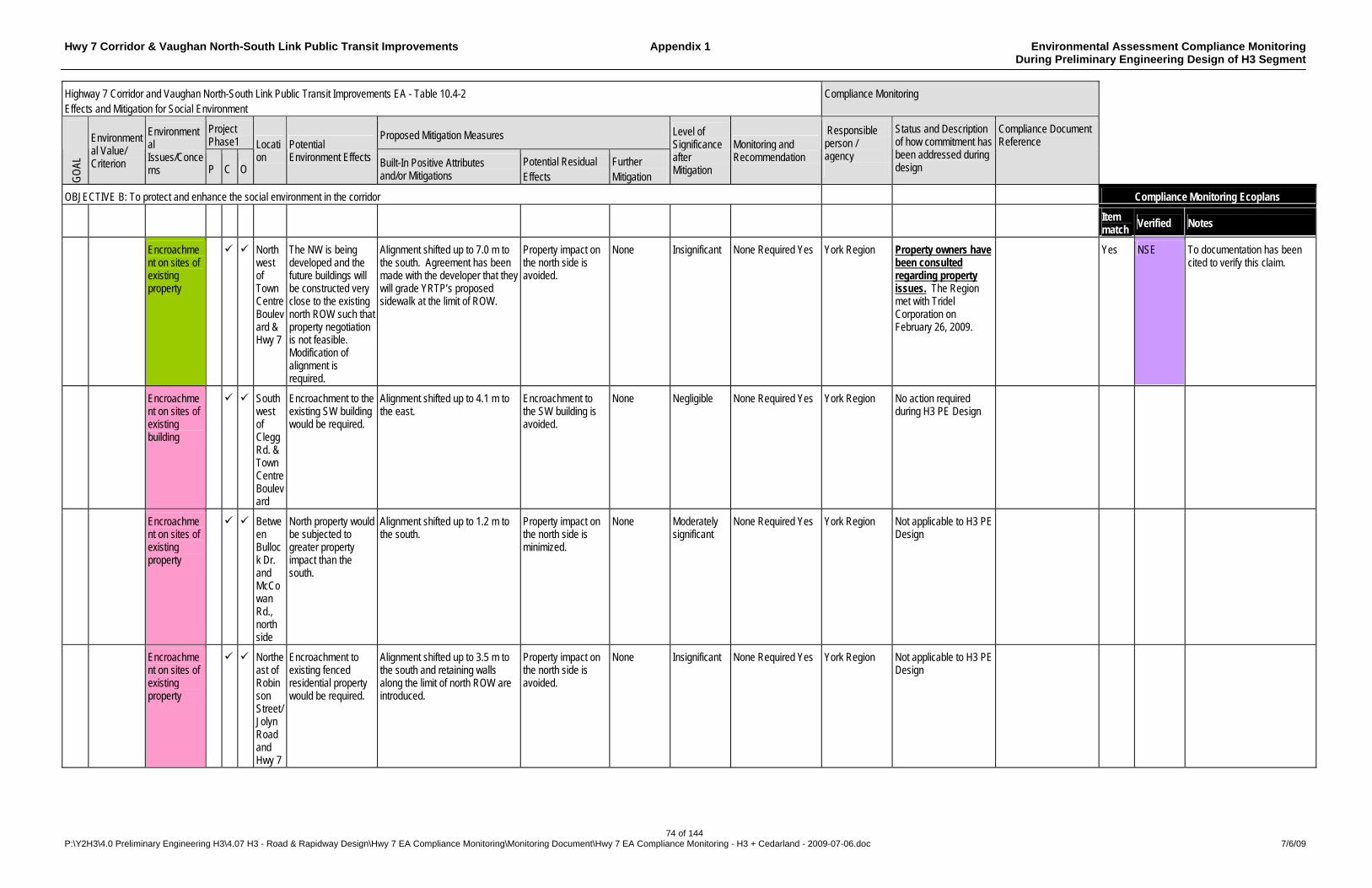
Hwy 7 Corridor & Vaughan North-South Link Public Transit Improvements Appendix 1 Environmental Assessment Compliance Monitoring During Preliminary Engineering Design of H3 Segment
74 of 144 P:\Y2H3\4.0 Preliminary Engineering H3\4.07 H3 - Road & Rapidway Design\Hwy 7 EA Compliance Monitoring\Monitoring Document\Hwy 7 EA Compliance Monitoring - H3 + Cedarland - 2009-07-06.doc 7/6/09
Highway 7 Corridor and Vaughan North-South Link Public Transit Improvements EA - Table 10.4-2 Effects and Mitigation for Social Environment
Compliance Monitoring
Project Phase1
Proposed Mitigation Measures
GO
AL
Environmental Value/ Criterion
Environmental Issues/Concerns P C O
Location
Potential Environment Effects Built-In Positive Attributes
and/or Mitigations Potential Residual Effects
Further Mitigation
Level of Significance after Mitigation
Monitoring and Recommendation
Responsible person / agency
Status and Description of how commitment has been addressed during design
Compliance Document Reference
OBJECTIVE B: To protect and enhance the social environment in the corridor Compliance Monitoring Ecoplans
Item match
Verified Notes
Encroachment on sites of existing property
Northwest of Town Centre Boulevard & Hwy 7
The NW is being developed and the future buildings will be constructed very close to the existing north ROW such that property negotiation is not feasible. Modification of alignment is required.
Alignment shifted up to 7.0 m to the south. Agreement has been made with the developer that they will grade YRTP’s proposed sidewalk at the limit of ROW.
Property impact on the north side is avoided.
None Insignificant None Required Yes York Region Property owners have been consulted regarding property issues. The Region met with Tridel Corporation on February 26, 2009.
Yes NSE To documentation has been cited to verify this claim.
Encroachment on sites of existing building
Southwest of Clegg Rd. & Town Centre Boulevard
Encroachment to the existing SW building would be required.
Alignment shifted up to 4.1 m to the east.
Encroachment to the SW building is avoided.
None Negligible None Required Yes York Region No action required during H3 PE Design
Encroachment on sites of existing property
Between Bullock Dr. and McCowan Rd., north side
North property would be subjected to greater property impact than the south.
Alignment shifted up to 1.2 m to the south.
Property impact on the north side is minimized.
None Moderately significant
None Required Yes York Region Not applicable to H3 PE Design
Encroachment on sites of existing property
Northeast of Robinson Street/ Jolyn Road and Hwy 7
Encroachment to existing fenced residential property would be required.
Alignment shifted up to 3.5 m to the south and retaining walls along the limit of north ROW are introduced.
Property impact on the north side is avoided.
None Insignificant None Required Yes York Region Not applicable to H3 PE Design
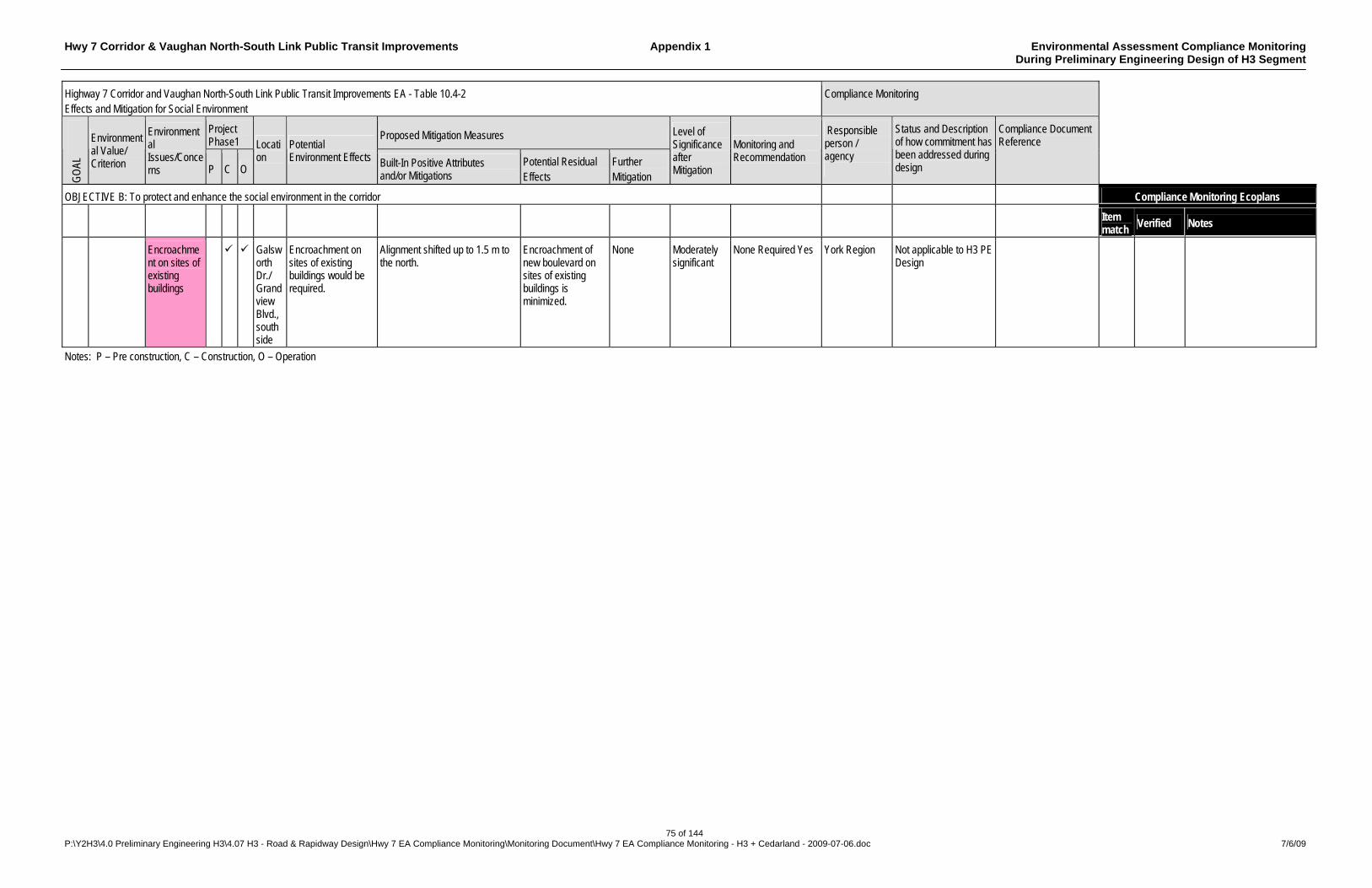
Hwy 7 Corridor & Vaughan North-South Link Public Transit Improvements Appendix 1 Environmental Assessment Compliance Monitoring During Preliminary Engineering Design of H3 Segment
75 of 144 P:\Y2H3\4.0 Preliminary Engineering H3\4.07 H3 - Road & Rapidway Design\Hwy 7 EA Compliance Monitoring\Monitoring Document\Hwy 7 EA Compliance Monitoring - H3 + Cedarland - 2009-07-06.doc 7/6/09
Highway 7 Corridor and Vaughan North-South Link Public Transit Improvements EA - Table 10.4-2 Effects and Mitigation for Social Environment
Compliance Monitoring
Project Phase1
Proposed Mitigation Measures
GO
AL
Environmental Value/ Criterion
Environmental Issues/Concerns P C O
Location
Potential Environment Effects Built-In Positive Attributes
and/or Mitigations Potential Residual Effects
Further Mitigation
Level of Significance after Mitigation
Monitoring and Recommendation
Responsible person / agency
Status and Description of how commitment has been addressed during design
Compliance Document Reference
OBJECTIVE B: To protect and enhance the social environment in the corridor Compliance Monitoring Ecoplans
Item match
Verified Notes
Encroachment on sites of existing buildings
Galsworth Dr./ Grandview Blvd., south side
Encroachment on sites of existing buildings would be required.
Alignment shifted up to 1.5 m to the north.
Encroachment of new boulevard on sites of existing buildings is minimized.
None Moderately significant
None Required Yes York Region Not applicable to H3 PE Design
Notes: P – Pre construction, C – Construction, O – Operation

Hwy 7 Corridor & Vaughan North-South Link Public Transit Improvements Appendix 1 Environmental Assessment Compliance Monitoring During Preliminary Engineering Design of H3 Segment
76 of 144 P:\Y2H3\4.0 Preliminary Engineering H3\4.07 H3 - Road & Rapidway Design\Hwy 7 EA Compliance Monitoring\Monitoring Document\Hwy 7 EA Compliance Monitoring - H3 + Cedarland - 2009-07-06.doc 7/6/09
Highway 7 Corridor and Vaughan North-South Link Public Transit Improvements EA - Table 10.4-3 Effects and Mitigation for Natural Environment
Compliance Monitoring
Project Phase1
Proposed Mitigation Measures
GO
AL
Environmental Value/ Criterion
Environmental Issues/Concerns P C O
Location Potential Environment Effects Built-In Positive
Attributes and/or Mitigations
Potential Residual Effects
Further Mitigation
Level of Significance after Mitigation
Monitoring and Recommendation
Responsible person / agency
Status and Description of how commitment has been addressed during design
Compliance Document Reference
Compliance Monitoring Ecoplans OBJECTIVE C: To protect and enhance the natural environment in the corridor
Item match
Verified Notes
C1 Minimize adverse effects on Aquatic Ecosystems
Fuel spills, due to accidents during construction refuelling and accidents during operation, entering the watercourses
Entire Corridor
Fish kills due to chemical spills resulting in short term population decline.
No refuelling within 10 m of a watercourse. Emergency Response Plan.
Short term population decline. Some contaminants within storm-water system.
None practical
Insignificant None required Yes York Region An Emergency Response Plan will be developed during detailed design.
Sediment laden stormwater entering watercourses during construction
Entire Corridor
Fish kills and loss of aquatic habitat resulting in short term population decline.
Construction fencing at work areas near watercourses limiting area of disturbance. Erosion and Sedimentation Control Plan.
Short term population decline.
None practical
Insignificant None required York Region A draft Stormwater Management Plan has been prepared during PE design as detailed in DBCR - Appendix H – Drainage & Hydrology Report Highway 7 Corridor (H3) – August 2008 - Sections 5.2 & 7. SWMP to be finalised in the detailed design phase. An Environmental Protection Plan was prepared during detail design for Phase 1 construction from Warden Avenue to Birchmount Road
Draft Drainage & Hydrology Report Highway 7 Corridor (H3) – Y2H3 4.05 (ID# 3230) - Hwy 404 to Kennedy report in progress. Environmental Protection Plan – ESP 1.01 (ID# 4111, 4112)
Yes ECF
4111 – Env. Protection plan Drawing st 540+480 to Sta. 541-050 (11-Mar-09) 4112 – Memo – Use of Tarps (13-Mar-09)
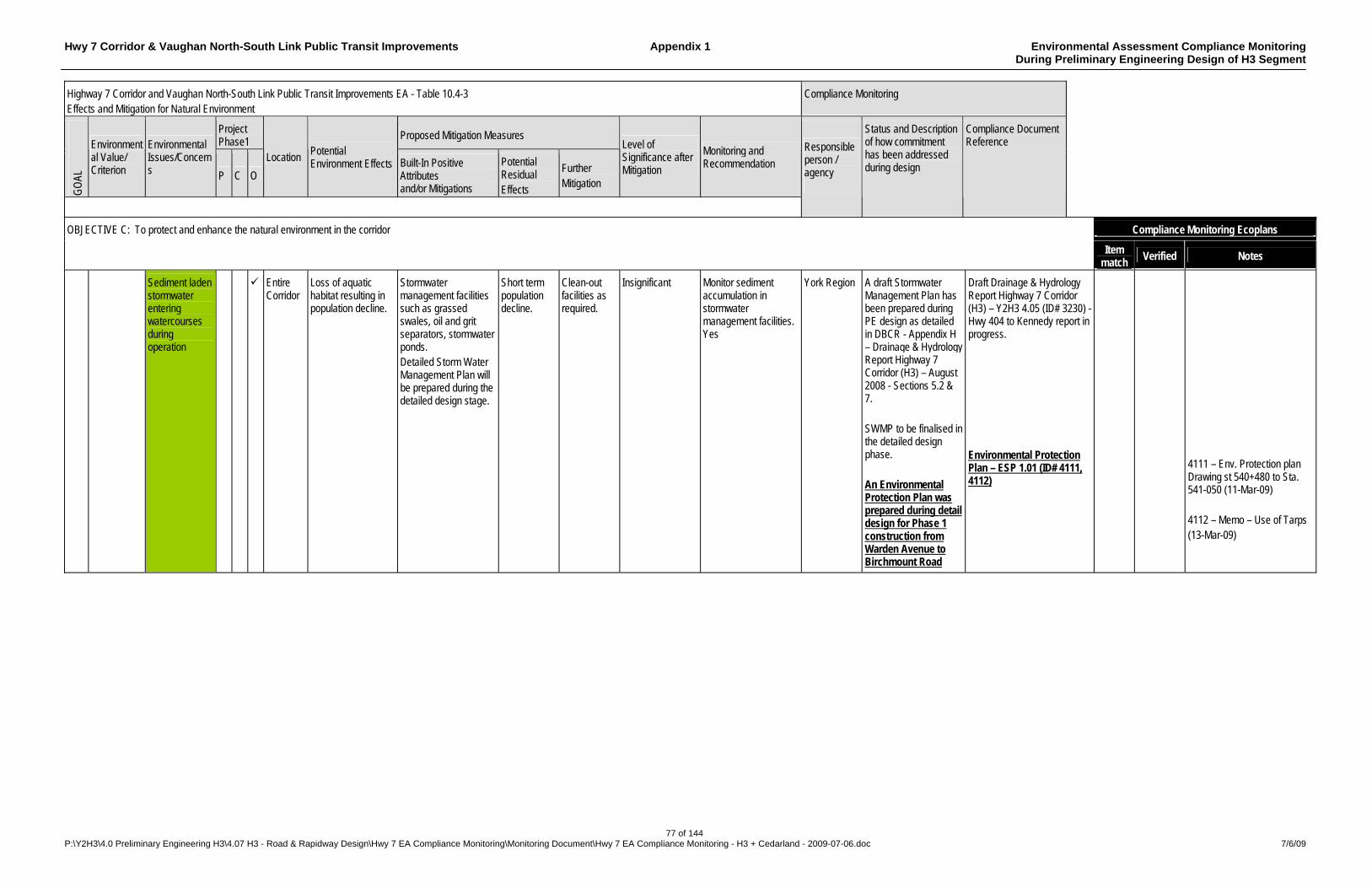
Hwy 7 Corridor & Vaughan North-South Link Public Transit Improvements Appendix 1 Environmental Assessment Compliance Monitoring During Preliminary Engineering Design of H3 Segment
77 of 144 P:\Y2H3\4.0 Preliminary Engineering H3\4.07 H3 - Road & Rapidway Design\Hwy 7 EA Compliance Monitoring\Monitoring Document\Hwy 7 EA Compliance Monitoring - H3 + Cedarland - 2009-07-06.doc 7/6/09
Highway 7 Corridor and Vaughan North-South Link Public Transit Improvements EA - Table 10.4-3 Effects and Mitigation for Natural Environment
Compliance Monitoring
Project Phase1
Proposed Mitigation Measures
GO
AL
Environmental Value/ Criterion
Environmental Issues/Concerns P C O
Location Potential Environment Effects Built-In Positive
Attributes and/or Mitigations
Potential Residual Effects
Further Mitigation
Level of Significance after Mitigation
Monitoring and Recommendation
Responsible person / agency
Status and Description of how commitment has been addressed during design
Compliance Document Reference
Compliance Monitoring Ecoplans OBJECTIVE C: To protect and enhance the natural environment in the corridor
Item match
Verified Notes
Sediment laden stormwater entering watercourses during operation
Entire Corridor
Loss of aquatic habitat resulting in population decline.
Stormwater management facilities such as grassed swales, oil and grit separators, stormwater ponds. Detailed Storm Water Management Plan will be prepared during the detailed design stage.
Short term population decline.
Clean-out facilities as required.
Insignificant Monitor sediment accumulation in stormwater management facilities. Yes
York Region A draft Stormwater Management Plan has been prepared during PE design as detailed in DBCR - Appendix H – Drainage & Hydrology Report Highway 7 Corridor (H3) – August 2008 - Sections 5.2 & 7. SWMP to be finalised in the detailed design phase. An Environmental Protection Plan was prepared during detail design for Phase 1 construction from Warden Avenue to Birchmount Road
Draft Drainage & Hydrology Report Highway 7 Corridor (H3) – Y2H3 4.05 (ID# 3230) - Hwy 404 to Kennedy report in progress. Environmental Protection Plan – ESP 1.01 (ID# 4111, 4112)
4111 – Env. Protection plan Drawing st 540+480 to Sta. 541-050 (11-Mar-09) 4112 – Memo – Use of Tarps (13-Mar-09)
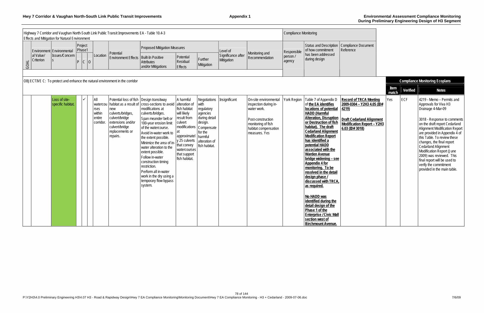
Hwy 7 Corridor & Vaughan North-South Link Public Transit Improvements Appendix 1 Environmental Assessment Compliance Monitoring During Preliminary Engineering Design of H3 Segment
78 of 144 P:\Y2H3\4.0 Preliminary Engineering H3\4.07 H3 - Road & Rapidway Design\Hwy 7 EA Compliance Monitoring\Monitoring Document\Hwy 7 EA Compliance Monitoring - H3 + Cedarland - 2009-07-06.doc 7/6/09
Highway 7 Corridor and Vaughan North-South Link Public Transit Improvements EA - Table 10.4-3 Effects and Mitigation for Natural Environment
Compliance Monitoring
Project Phase1
Proposed Mitigation Measures
GO
AL
Environmental Value/ Criterion
Environmental Issues/Concerns P C O
Location Potential Environment Effects Built-In Positive
Attributes and/or Mitigations
Potential Residual Effects
Further Mitigation
Level of Significance after Mitigation
Monitoring and Recommendation
Responsible person / agency
Status and Description of how commitment has been addressed during design
Compliance Document Reference
Compliance Monitoring Ecoplans OBJECTIVE C: To protect and enhance the natural environment in the corridor
Item match
Verified Notes
Loss of site-specific habitat.
All watercourses within entire corridor.
Potential loss of fish habitat as a result of new culverts/bridges, culvert/bridge extensions and/or culvert/bridge replacements or repairs.
Design transitway cross-sections to avoid modifications at culverts/bridges. Span meander belt or 100-year erosion limit of the watercourse. Avoid in-water work to the extent possible. Minimize the area of in-water alteration to the extent possible. Follow in-water construction timing restriction. Perform all in-water work in the dry using a temporary flow bypass system.
A harmful alteration of fish habitat will likely result from culvert modifications at approximately 25 culverts that convey watercourses that support fish habitat.
Negotiations with regulatory agencies during detail design. Compensate for the harmful alteration of fish habitat.
Insignificant On-site environmental inspection during in-water work. Post-construction monitoring of fish habitat compensation measures. Yes
York Region Table 7 of Appendix D of the EA identifies locations of potential HADD (Harmful Alteration, Disruption or Destruction of fish habitat). The draft Cedarland Alignment Modification Report has identified a potential HADD associated with the Warden Avenue bridge widening – see Appendix 4 for monitoring. To be resolved in the detail design phase / discussed with TRCA, as required. No HADD was identified during the detail design of the Phase 1 of the Enterprise / Civic Mall section west of Birchmount Avenue.
Record of TRCA Meeting 2009-0304 – Y2H3 4.05 (ID# 4219) Draft Cedarland Alignment Modification Report – Y2H3 6.03 (ID# 3018)
Yes ECF 4219 - Memo – Permits and Approvals for Viva H3 Drainage 4-Mar-09 3018 - Response to comments on the draft report Cedarland Alignment Modification Report are provided in Appendix 4 of this Table. To review these changes, the final report Cedarland Alignment Modification Report (June 2009) was reviewed. This final report will be used to verify the commitment provided in the main table.
Hwy 7 Corridor & Vaughan North-South Link Public Transit Improvements Appendix 1 Environmental Assessment Compliance Monitoring During Preliminary Engineering Design of H3 Segment
79 of 144 P:\Y2H3\4.0 Preliminary Engineering H3\4.07 H3 - Road & Rapidway Design\Hwy 7 EA Compliance Monitoring\Monitoring Document\Hwy 7 EA Compliance Monitoring - H3 + Cedarland - 2009-07-06.doc 7/6/09
Highway 7 Corridor and Vaughan North-South Link Public Transit Improvements EA - Table 10.4-3 Effects and Mitigation for Natural Environment
Compliance Monitoring
Project Phase1
Proposed Mitigation Measures
GO
AL
Environmental Value/ Criterion
Environmental Issues/Concerns P C O
Location Potential Environment Effects Built-In Positive
Attributes and/or Mitigations
Potential Residual Effects
Further Mitigation
Level of Significance after Mitigation
Monitoring and Recommendation
Responsible person / agency
Status and Description of how commitment has been addressed during design
Compliance Document Reference
Compliance Monitoring Ecoplans OBJECTIVE C: To protect and enhance the natural environment in the corridor
Item match
Verified Notes
C1 cont’d
Minimize adverse effects on Aquatic Ecosystems (cont’d)
Fish mortality All watercourses within entire corridor.
Fish may be injured or killed by dewatering.
Design transitway cross-sections to avoid modifications at culverts/bridges. Avoid in-water work to the extent possible. Perform all in-water work in the dry using a temporary flow bypass system. Capture fish trapped during dewatering of the work zone and safely release upstream. Prohibit the entry of heavy equipment into the watercourse.
None expected.
None Negligible On-site environmental inspection during in-water work. Yes
York Region Provision for site-specific measures for in-water work will be made in the detailed design phase – See also item 36 of this document.
Barriers to fish movement.
All watercourses within entire corridor.
Culvert/bridge extension, repair or replacement may create a barrier to fish movement.
Use open footing culverts or countersink closed culverts a minimum of 20% of culvert diameter. Span the watercourse, meander belt or floodplain with new structures where warranted by site conditions.
Culvert extensions will be designed to avoid the creation of a barrier to fish movement.
Negotiations with regulatory agencies during detail design.
Negligible On-site environmental inspection during in-water work. Yes
York Region To be resolved in the detail design phase / discussed with TRCA, as required.
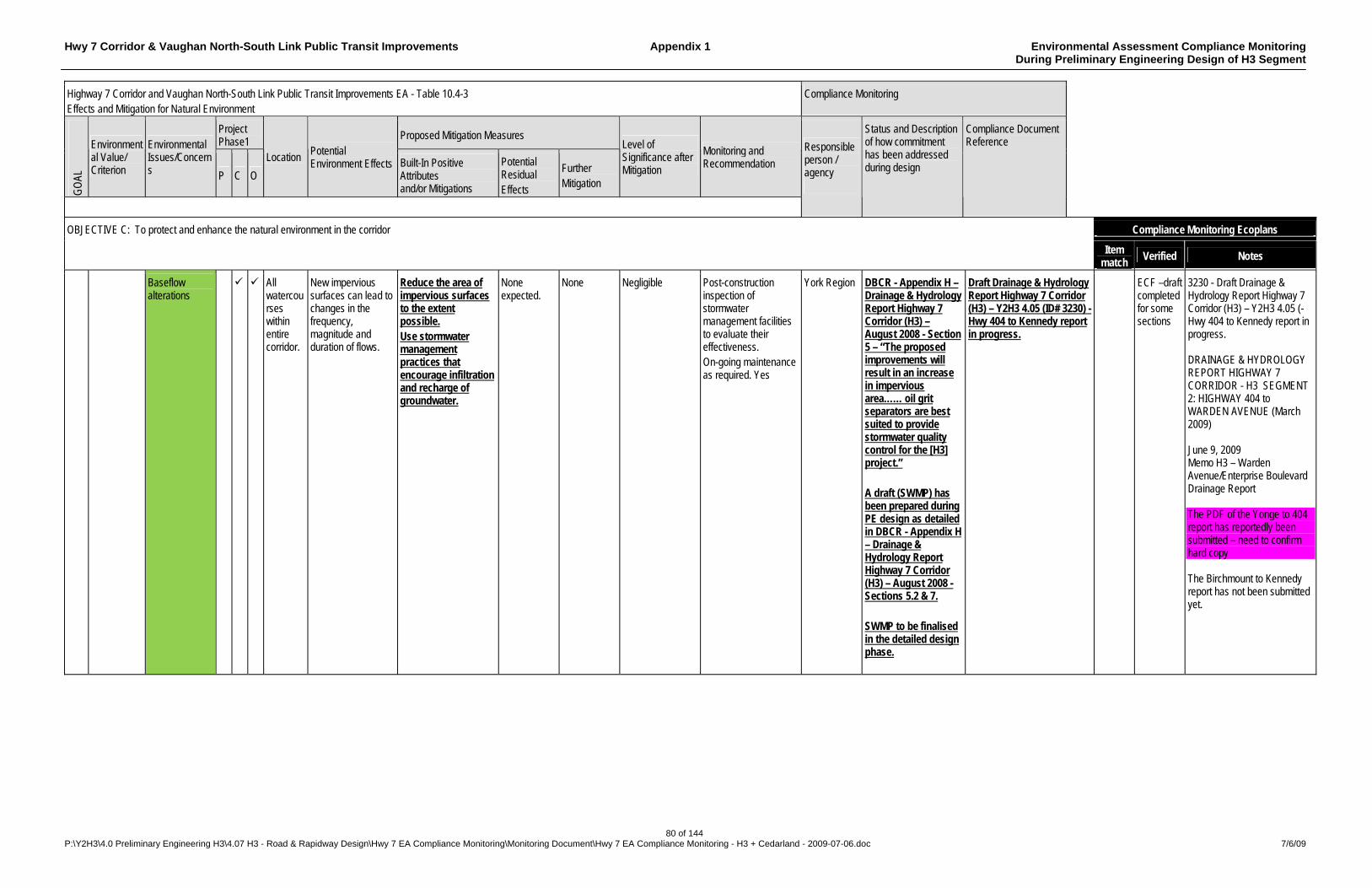
Hwy 7 Corridor & Vaughan North-South Link Public Transit Improvements Appendix 1 Environmental Assessment Compliance Monitoring During Preliminary Engineering Design of H3 Segment
80 of 144 P:\Y2H3\4.0 Preliminary Engineering H3\4.07 H3 - Road & Rapidway Design\Hwy 7 EA Compliance Monitoring\Monitoring Document\Hwy 7 EA Compliance Monitoring - H3 + Cedarland - 2009-07-06.doc 7/6/09
Highway 7 Corridor and Vaughan North-South Link Public Transit Improvements EA - Table 10.4-3 Effects and Mitigation for Natural Environment
Compliance Monitoring
Project Phase1
Proposed Mitigation Measures
GO
AL
Environmental Value/ Criterion
Environmental Issues/Concerns P C O
Location Potential Environment Effects Built-In Positive
Attributes and/or Mitigations
Potential Residual Effects
Further Mitigation
Level of Significance after Mitigation
Monitoring and Recommendation
Responsible person / agency
Status and Description of how commitment has been addressed during design
Compliance Document Reference
Compliance Monitoring Ecoplans OBJECTIVE C: To protect and enhance the natural environment in the corridor
Item match
Verified Notes
Baseflow alterations
All watercourses within entire corridor.
New impervious surfaces can lead to changes in the frequency, magnitude and duration of flows.
Reduce the area of impervious surfaces to the extent possible. Use stormwater management practices that encourage infiltration and recharge of groundwater.
None expected.
None Negligible Post-construction inspection of stormwater management facilities to evaluate their effectiveness. On-going maintenance as required. Yes
York Region DBCR - Appendix H – Drainage & Hydrology Report Highway 7 Corridor (H3) – August 2008 - Section 5 – “The proposed improvements will result in an increase in impervious area…… oil grit separators are best suited to provide stormwater quality control for the [H3] project.” A draft (SWMP) has been prepared during PE design as detailed in DBCR - Appendix H – Drainage & Hydrology Report Highway 7 Corridor (H3) – August 2008 - Sections 5.2 & 7. SWMP to be finalised in the detailed design phase.
Draft Drainage & Hydrology Report Highway 7 Corridor (H3) – Y2H3 4.05 (ID# 3230) - Hwy 404 to Kennedy report in progress.
ECF –draft completed for some sections
3230 - Draft Drainage & Hydrology Report Highway 7 Corridor (H3) – Y2H3 4.05 (- Hwy 404 to Kennedy report in progress. DRAINAGE & HYDROLOGY REPORT HIGHWAY 7 CORRIDOR - H3 SEGMENT 2: HIGHWAY 404 to WARDEN AVENUE (March 2009) June 9, 2009 Memo H3 – Warden Avenue/Enterprise Boulevard Drainage Report The PDF of the Yonge to 404 report has reportedly been submitted – need to confirm hard copy The Birchmount to Kennedy report has not been submitted yet.

Hwy 7 Corridor & Vaughan North-South Link Public Transit Improvements Appendix 1 Environmental Assessment Compliance Monitoring During Preliminary Engineering Design of H3 Segment
81 of 144 P:\Y2H3\4.0 Preliminary Engineering H3\4.07 H3 - Road & Rapidway Design\Hwy 7 EA Compliance Monitoring\Monitoring Document\Hwy 7 EA Compliance Monitoring - H3 + Cedarland - 2009-07-06.doc 7/6/09
Highway 7 Corridor and Vaughan North-South Link Public Transit Improvements EA - Table 10.4-3 Effects and Mitigation for Natural Environment
Compliance Monitoring
Project Phase1
Proposed Mitigation Measures
GO
AL
Environmental Value/ Criterion
Environmental Issues/Concerns P C O
Location Potential Environment Effects Built-In Positive
Attributes and/or Mitigations
Potential Residual Effects
Further Mitigation
Level of Significance after Mitigation
Monitoring and Recommendation
Responsible person / agency
Status and Description of how commitment has been addressed during design
Compliance Document Reference
Compliance Monitoring Ecoplans OBJECTIVE C: To protect and enhance the natural environment in the corridor
Item match
Verified Notes
Increased temperature
All watercourses within entire corridor
Clearing of riparian vegetation and stormwater management practices can impact temperature regimes.
Minimize the area of stream bank alteration to the extent possible. Use stormwater management practices that encourage infiltration and recharge of groundwater.
Shading provided by culvert/bridge offsets shading lost through removal of riparian vegetation.
Restore riparian areas disturbed during construction with native vegetation.
Negligible Post-construction inspection of stormwater management facilities to evaluate their effectiveness. On-going maintenance as required. Post-construction inspection of riparian plantings to confirm survival. Yes
York Region An Environmental Control Plan will be developed during detailed design. A draft (SWMP) has been prepared during PE design as detailed in DBCR - Appendix H – Drainage & Hydrology Report Highway 7 Corridor (H3) – August 2008 - Sections 5.2 & 7. SWMP to be finalised in the detailed design phase.
Draft Drainage & Hydrology Report Highway 7 Corridor (H3) – Y2H3 4.05 (ID# 3230) - Hwy 404 to Kennedy report in progress.
ECF –draft completed for some sections
Draft Drainage & Hydrology Report Highway 7 Corridor (H3) – Y2H3 4.05 (ID# 3230) - Hwy 404 to Kennedy report in progress. DRAINAGE & HYDROLOGY REPORT HIGHWAY 7 CORRIDOR - H3 SEGMENT 2: HIGHWAY 404 to WARDEN AVENUE (March 2009) June 9, 2009 Memo H3 – Warden Avenue/Enterprise Boulevard Drainage Report The PDF of the Yonge to 404 report has reportedly been submitted – need to confirm hard copy The Birchmount to Kennedy report has not been submitted yet.

Hwy 7 Corridor & Vaughan North-South Link Public Transit Improvements Appendix 1 Environmental Assessment Compliance Monitoring During Preliminary Engineering Design of H3 Segment
82 of 144 P:\Y2H3\4.0 Preliminary Engineering H3\4.07 H3 - Road & Rapidway Design\Hwy 7 EA Compliance Monitoring\Monitoring Document\Hwy 7 EA Compliance Monitoring - H3 + Cedarland - 2009-07-06.doc 7/6/09
Highway 7 Corridor and Vaughan North-South Link Public Transit Improvements EA - Table 10.4-3 Effects and Mitigation for Natural Environment
Compliance Monitoring
Project Phase1
Proposed Mitigation Measures
GO
AL
Environmental Value/ Criterion
Environmental Issues/Concerns P C O
Location Potential Environment Effects Built-In Positive
Attributes and/or Mitigations
Potential Residual Effects
Further Mitigation
Level of Significance after Mitigation
Monitoring and Recommendation
Responsible person / agency
Status and Description of how commitment has been addressed during design
Compliance Document Reference
Compliance Monitoring Ecoplans OBJECTIVE C: To protect and enhance the natural environment in the corridor
Item match
Verified Notes
Disturbance to rare, threatened or endangered species
All watersheds within entire corridor.
Humber River watershed known to support redside dace, American brook lamprey, and central stoneroller. Don River watershed known to support redside dace and American brook lamprey. Rouge River watershed known to support redside dace, American brook lamprey, and central stoneroller.
Design transitway cross-sections to avoid modifications at culverts/bridges. Mixed traffic operation has been introduced at the Humber River, West Don River, East Don River and Little Rouge Creek bridges to avoid widening and disturbance to rare, threatened and endangered species. Avoid in-water work to the extent possible. Perform all in-water work in the dry using a temporary flow bypass system. Capture fish trapped during dewatering of the work zone and safely release upstream. Prohibit the entry of heavy equipment into the watercourse.
None expected.
None required.
Negligible None required. Yes York Region An Environmental Control Plan will be developed during detailed design.
Hwy 7 Corridor & Vaughan North-South Link Public Transit Improvements Appendix 1 Environmental Assessment Compliance Monitoring During Preliminary Engineering Design of H3 Segment
83 of 144 P:\Y2H3\4.0 Preliminary Engineering H3\4.07 H3 - Road & Rapidway Design\Hwy 7 EA Compliance Monitoring\Monitoring Document\Hwy 7 EA Compliance Monitoring - H3 + Cedarland - 2009-07-06.doc 7/6/09
Highway 7 Corridor and Vaughan North-South Link Public Transit Improvements EA - Table 10.4-3 Effects and Mitigation for Natural Environment
Compliance Monitoring
Project Phase1
Proposed Mitigation Measures
GO
AL
Environmental Value/ Criterion
Environmental Issues/Concerns P C O
Location Potential Environment Effects Built-In Positive
Attributes and/or Mitigations
Potential Residual Effects
Further Mitigation
Level of Significance after Mitigation
Monitoring and Recommendation
Responsible person / agency
Status and Description of how commitment has been addressed during design
Compliance Document Reference
Compliance Monitoring Ecoplans OBJECTIVE C: To protect and enhance the natural environment in the corridor
Item match
Verified Notes
C2 Minimize adverse effects on Terrestrial Ecosystems
Loss of wildlife habitat and ecological functions
Entire corridor.
Construction of the transitway and associated facilities may result in the removal of vegetation and ecological functions it supports.
Minimize the area of vegetation removals to the extent possible. Minimize grade changes to the extent possible. Use close cut clearing and trimming to minimize the number of trees to be removed. Delineate work zones using construction fencing/tree protection barrier. Protect trees within the clear zone using guiderail, curbs, etc. to prevent removal.
None expected.
Restore natural areas disturbed using construction with native vegetation, where feasible. Replace ornamental vegetation as part of landscaping.
Negligible None required. York Region A draft (SWMP) has been prepared during PE design as detailed in DBCR - Appendix H – Drainage & Hydrology Report Highway 7 Corridor (H3) – August 2008 - Sections 5.2 & 7. Section 6.0 of the Drainage & Hydrology Report proposes corresponding mitigation measures for an Environmental Control Plan, which will be developed during detailed design.
Draft Drainage & Hydrology Report Highway 7 Corridor (H3) – Y2H3 4.05 (ID# 3230) - Hwy 404 to Kennedy report in progress.
Yes ECF 3230 - Draft Drainage & Hydrology Report Highway 7 Corridor (H3) – Y2H3 4.05 (- Hwy 404 to Kennedy report in progress. DRAINAGE & HYDROLOGY REPORT HIGHWAY 7 CORRIDOR - H3 SEGMENT 2: HIGHWAY 404 to WARDEN AVENUE (March 2009) June 9, 2009 Memo H3 – Warden Avenue/Enterprise Boulevard Drainage Report The PDF of the Yonge to 404 report has reportedly been submitted – need to confirm hard copy The Birchmount to Kennedy report has not been submitted yet.
Wildlife mortality
Entire corridor.
Removal of wildlife habitat may result in wildlife mortality.
Perform vegetation removals outside of wildlife breeding seasons (typically April 1 to July 31). Perform culvert/bridge extension, repair and replacement outside of wildlife breeding season.
None expected.
None required.
Negligible None required. York Region An Environmental Control Plan will be developed during detailed design.
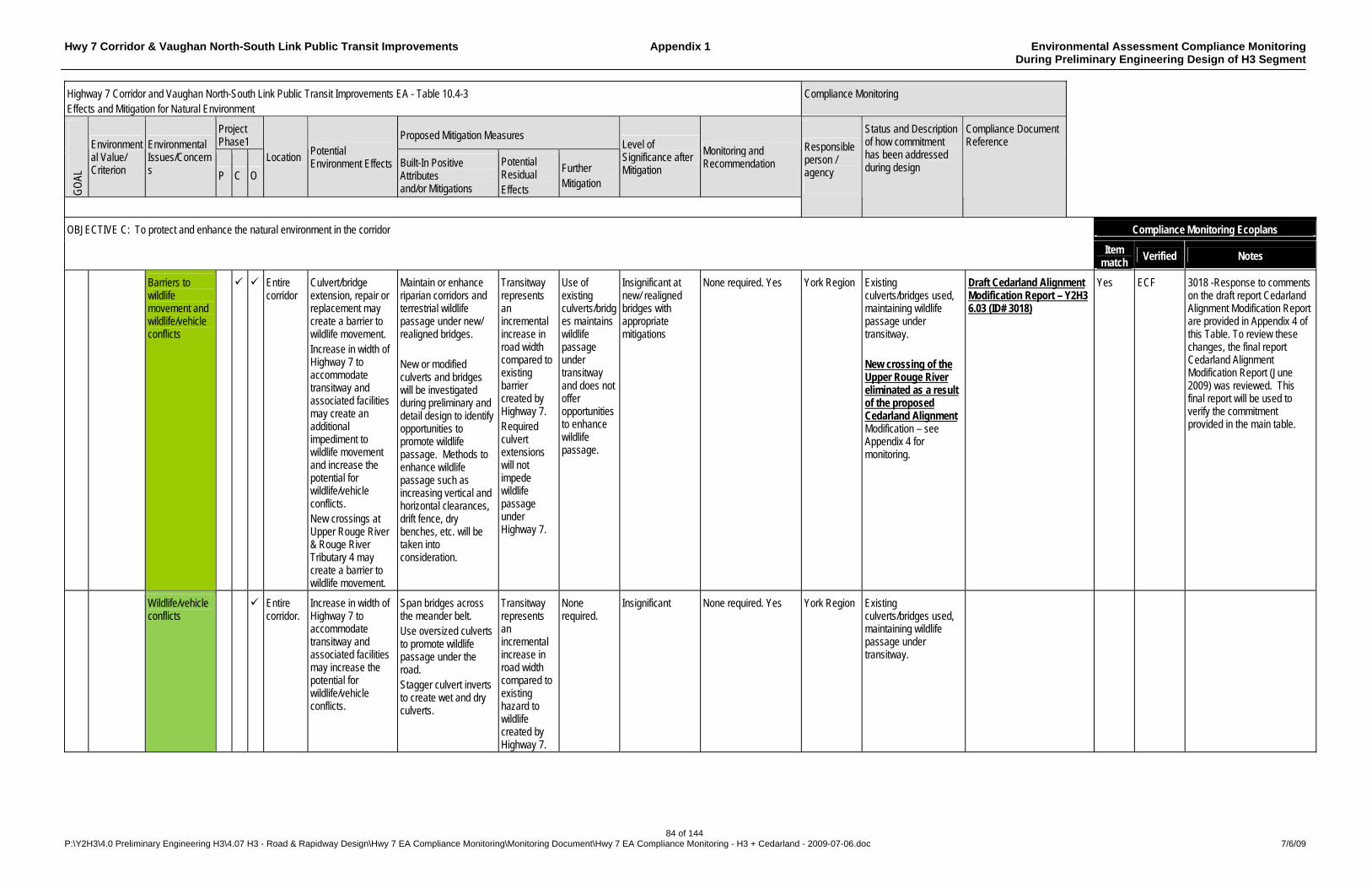
Hwy 7 Corridor & Vaughan North-South Link Public Transit Improvements Appendix 1 Environmental Assessment Compliance Monitoring During Preliminary Engineering Design of H3 Segment
84 of 144 P:\Y2H3\4.0 Preliminary Engineering H3\4.07 H3 - Road & Rapidway Design\Hwy 7 EA Compliance Monitoring\Monitoring Document\Hwy 7 EA Compliance Monitoring - H3 + Cedarland - 2009-07-06.doc 7/6/09
Highway 7 Corridor and Vaughan North-South Link Public Transit Improvements EA - Table 10.4-3 Effects and Mitigation for Natural Environment
Compliance Monitoring
Project Phase1
Proposed Mitigation Measures
GO
AL
Environmental Value/ Criterion
Environmental Issues/Concerns P C O
Location Potential Environment Effects Built-In Positive
Attributes and/or Mitigations
Potential Residual Effects
Further Mitigation
Level of Significance after Mitigation
Monitoring and Recommendation
Responsible person / agency
Status and Description of how commitment has been addressed during design
Compliance Document Reference
Compliance Monitoring Ecoplans OBJECTIVE C: To protect and enhance the natural environment in the corridor
Item match
Verified Notes
Barriers to wildlife movement and wildlife/vehicle conflicts
Entire corridor
Culvert/bridge extension, repair or replacement may create a barrier to wildlife movement. Increase in width of Highway 7 to accommodate transitway and associated facilities may create an additional impediment to wildlife movement and increase the potential for wildlife/vehicle conflicts. New crossings at Upper Rouge River & Rouge River Tributary 4 may create a barrier to wildlife movement.
Maintain or enhance riparian corridors and terrestrial wildlife passage under new/ realigned bridges. New or modified culverts and bridges will be investigated during preliminary and detail design to identify opportunities to promote wildlife passage. Methods to enhance wildlife passage such as increasing vertical and horizontal clearances, drift fence, dry benches, etc. will be taken into consideration.
Transitway represents an incremental increase in road width compared to existing barrier created by Highway 7. Required culvert extensions will not impede wildlife passage under Highway 7.
Use of existing culverts/bridges maintains wildlife passage under transitway and does not offer opportunities to enhance wildlife passage.
Insignificant at new/ realigned bridges with appropriate mitigations
None required. Yes York Region Existing culverts/bridges used, maintaining wildlife passage under transitway. New crossing of the Upper Rouge River eliminated as a result of the proposed Cedarland Alignment Modification – see Appendix 4 for monitoring.
Draft Cedarland Alignment Modification Report – Y2H3 6.03 (ID# 3018)
Yes ECF 3018 -Response to comments on the draft report Cedarland Alignment Modification Report are provided in Appendix 4 of this Table. To review these changes, the final report Cedarland Alignment Modification Report (June 2009) was reviewed. This final report will be used to verify the commitment provided in the main table.
Wildlife/vehicle conflicts
Entire corridor.
Increase in width of Highway 7 to accommodate transitway and associated facilities may increase the potential for wildlife/vehicle conflicts.
Span bridges across the meander belt. Use oversized culverts to promote wildlife passage under the road. Stagger culvert inverts to create wet and dry culverts.
Transitway represents an incremental increase in road width compared to existing hazard to wildlife created by Highway 7.
None required.
Insignificant None required. Yes York Region Existing culverts/bridges used, maintaining wildlife passage under transitway.
Hwy 7 Corridor & Vaughan North-South Link Public Transit Improvements Appendix 1 Environmental Assessment Compliance Monitoring During Preliminary Engineering Design of H3 Segment
85 of 144 P:\Y2H3\4.0 Preliminary Engineering H3\4.07 H3 - Road & Rapidway Design\Hwy 7 EA Compliance Monitoring\Monitoring Document\Hwy 7 EA Compliance Monitoring - H3 + Cedarland - 2009-07-06.doc 7/6/09
Highway 7 Corridor and Vaughan North-South Link Public Transit Improvements EA - Table 10.4-3 Effects and Mitigation for Natural Environment
Compliance Monitoring
Project Phase1
Proposed Mitigation Measures
GO
AL
Environmental Value/ Criterion
Environmental Issues/Concerns P C O
Location Potential Environment Effects Built-In Positive
Attributes and/or Mitigations
Potential Residual Effects
Further Mitigation
Level of Significance after Mitigation
Monitoring and Recommendation
Responsible person / agency
Status and Description of how commitment has been addressed during design
Compliance Document Reference
Compliance Monitoring Ecoplans OBJECTIVE C: To protect and enhance the natural environment in the corridor
Item match
Verified Notes
Disturbance to rare, threatened, or endangered wildlife
Entire corridor.
Three rare species were identified within the study area: rough-legged hawk (non-breeding migrant/vagrant, extremely rare breeding occurrence by MNR); northern shrike (non-breeding migrant/vagrant, very rare to uncommon breeding occurrence by MNR); and, milk snake (‘special concern’ by COSEWIC, and ‘rare to uncommon’ by MNR)
Prevent the harassment of eastern milk snake if encountered during construction. Perform vegetation removals outside of wildlife breeding seasons (typically April 1 to July 31). Perform culvert/bridge extension, repair and replacement outside of wildlife breeding season.
None expected.
None required.
Negligible None required. Yes York Region An Environmental Control Plan will be developed during detailed design.
Hwy 7 Corridor & Vaughan North-South Link Public Transit Improvements Appendix 1 Environmental Assessment Compliance Monitoring During Preliminary Engineering Design of H3 Segment
86 of 144 P:\Y2H3\4.0 Preliminary Engineering H3\4.07 H3 - Road & Rapidway Design\Hwy 7 EA Compliance Monitoring\Monitoring Document\Hwy 7 EA Compliance Monitoring - H3 + Cedarland - 2009-07-06.doc 7/6/09
Highway 7 Corridor and Vaughan North-South Link Public Transit Improvements EA - Table 10.4-3 Effects and Mitigation for Natural Environment
Compliance Monitoring
Project Phase1
Proposed Mitigation Measures
GO
AL
Environmental Value/ Criterion
Environmental Issues/Concerns P C O
Location Potential Environment Effects Built-In Positive
Attributes and/or Mitigations
Potential Residual Effects
Further Mitigation
Level of Significance after Mitigation
Monitoring and Recommendation
Responsible person / agency
Status and Description of how commitment has been addressed during design
Compliance Document Reference
Compliance Monitoring Ecoplans OBJECTIVE C: To protect and enhance the natural environment in the corridor
Item match
Verified Notes
C2 Cont’d
Minimize adverse effects on Terrestrial Ecosystems (cont’d)
Disturbance to vegetation through edge effects, drainage modifications and road salt
Entire corridor.
Clearing of new forest edges may result in sunscald, windthrow, and invasion of exotic species. Ditching, grading and other drainage modifications may alter local soil moisture regimes. Road salt may result in vegetation mortality and die back.
Minimize the area of vegetation removals to the extent possible. Minimize the grade changes and cut/fill requirements to the extent possible. Use close cut clearing and trimming to minimize encroachment on remaining vegetation. Delineate work zones using construction fencing/ tree protection barrier. Manage the application of road salt to the extent possible. TRCA guidelines for Forest Edge Management Plans & Post-Construction Restoration will be followed. All valley lands disturbed will require restoration with native herbaceous & woody species.
Vegetation communities within the study area are primarily cultural in origin and have been impacted by Highway 7. The transitway represents an incremental encroachment into these already disturbed communities.
Landscape treatments.
Insignificant None required. Yes York Region An Environmental Control Plan will be developed during detailed design.
Hwy 7 Corridor & Vaughan North-South Link Public Transit Improvements Appendix 1 Environmental Assessment Compliance Monitoring During Preliminary Engineering Design of H3 Segment
87 of 144 P:\Y2H3\4.0 Preliminary Engineering H3\4.07 H3 - Road & Rapidway Design\Hwy 7 EA Compliance Monitoring\Monitoring Document\Hwy 7 EA Compliance Monitoring - H3 + Cedarland - 2009-07-06.doc 7/6/09
Highway 7 Corridor and Vaughan North-South Link Public Transit Improvements EA - Table 10.4-3 Effects and Mitigation for Natural Environment
Compliance Monitoring
Project Phase1
Proposed Mitigation Measures
GO
AL
Environmental Value/ Criterion
Environmental Issues/Concerns P C O
Location Potential Environment Effects Built-In Positive
Attributes and/or Mitigations
Potential Residual Effects
Further Mitigation
Level of Significance after Mitigation
Monitoring and Recommendation
Responsible person / agency
Status and Description of how commitment has been addressed during design
Compliance Document Reference
Compliance Monitoring Ecoplans OBJECTIVE C: To protect and enhance the natural environment in the corridor
Item match
Verified Notes
Disturbance to rare, threatened or endangered flora
Entire Corridor.
Twenty-two regionally rare or uncommon species are located within the study limits including: Black Walnut, Common Evening Primrose, Cut-leaved Toothwort, Groundnut Hitchcock’s Sedge, Michigan Lily, Ninebark, Purple-stemmed Angelica, Red Cedar, Red Pine, Red-sheathed Bulrush, Sandbar Willow Shining Willow, Showy Tick-trefoil, Spike-rush Spotted Water Hemlock, Spring-beauty, Stickseed, Tall Beggar-ticks, Three-square Turtlehead, and Virginia Wild-rye.
Minimize the area of vegetation removals to the extent possible. Minimize grade changes to the extent possible. Use close cut clearing and trimming to minimize the number of trees to be removed. Delineate work zones using construction fencing/ tree protection barrier. Protect trees within the clear zone using guiderail, curbs, etc. to prevent removal. Transplant rare species to safe areas prior to construction.
Trees may be removed by the transitway and its associated facilities.
None required.
Insignificant Monitor clearing activities to ensure that minimum work zones are used to avoid any unnecessary tree removal. Yes
York Region An Environmental Control Plan will be developed during detailed design.
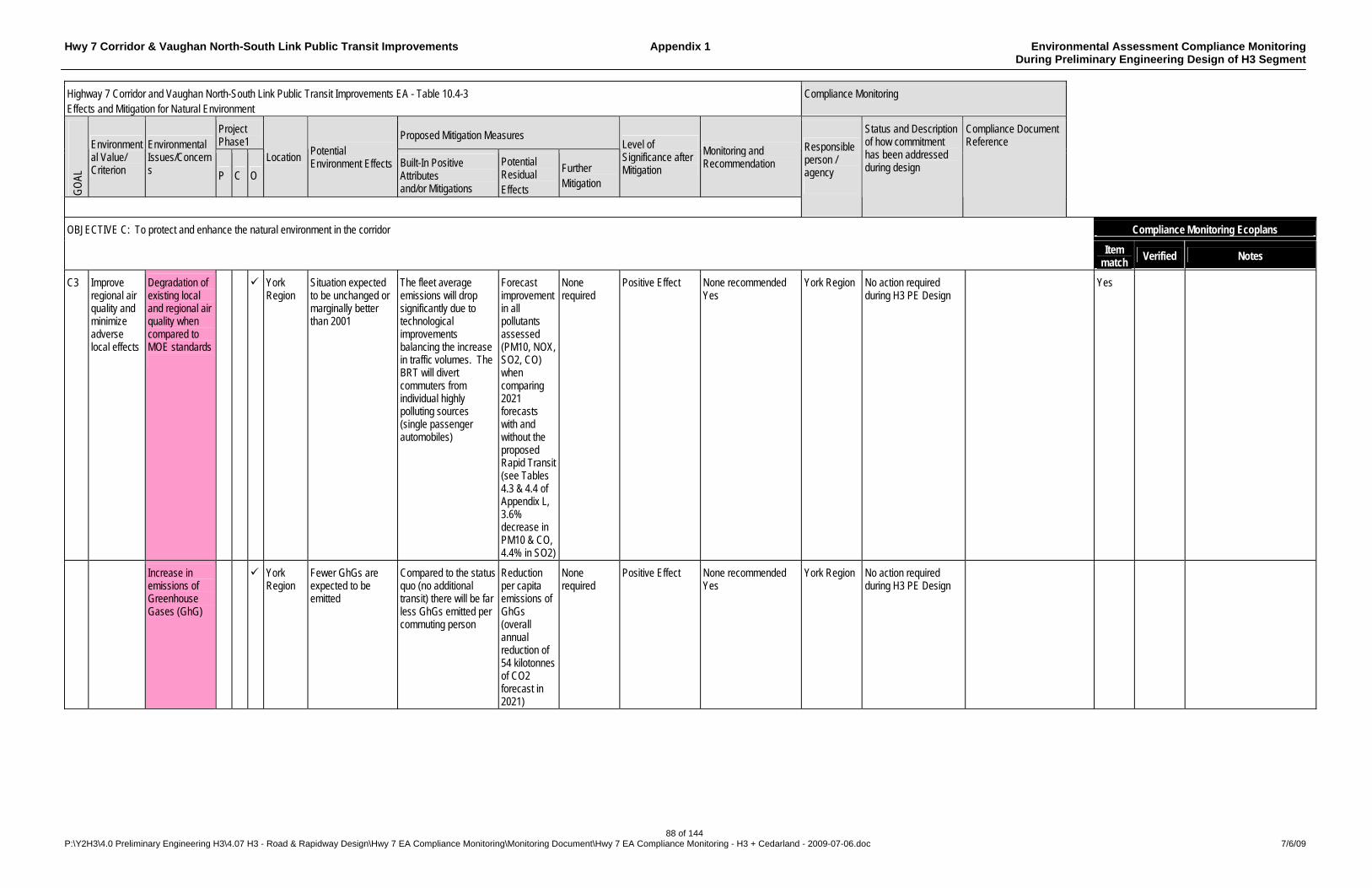
Hwy 7 Corridor & Vaughan North-South Link Public Transit Improvements Appendix 1 Environmental Assessment Compliance Monitoring During Preliminary Engineering Design of H3 Segment
88 of 144 P:\Y2H3\4.0 Preliminary Engineering H3\4.07 H3 - Road & Rapidway Design\Hwy 7 EA Compliance Monitoring\Monitoring Document\Hwy 7 EA Compliance Monitoring - H3 + Cedarland - 2009-07-06.doc 7/6/09
Highway 7 Corridor and Vaughan North-South Link Public Transit Improvements EA - Table 10.4-3 Effects and Mitigation for Natural Environment
Compliance Monitoring
Project Phase1
Proposed Mitigation Measures
GO
AL
Environmental Value/ Criterion
Environmental Issues/Concerns P C O
Location Potential Environment Effects Built-In Positive
Attributes and/or Mitigations
Potential Residual Effects
Further Mitigation
Level of Significance after Mitigation
Monitoring and Recommendation
Responsible person / agency
Status and Description of how commitment has been addressed during design
Compliance Document Reference
Compliance Monitoring Ecoplans OBJECTIVE C: To protect and enhance the natural environment in the corridor
Item match
Verified Notes
C3 Improve regional air quality and minimize adverse local effects
Degradation of existing local and regional air quality when compared to MOE standards
York Region
Situation expected to be unchanged or marginally better than 2001
The fleet average emissions will drop significantly due to technological improvements balancing the increase in traffic volumes. The BRT will divert commuters from individual highly polluting sources (single passenger automobiles)
Forecast improvement in all pollutants assessed (PM10, NOX, SO2, CO) when comparing 2021 forecasts with and without the proposed Rapid Transit (see Tables 4.3 & 4.4 of Appendix L, 3.6% decrease in PM10 & CO, 4.4% in SO2)
None required
Positive Effect None recommended Yes
York Region No action required during H3 PE Design
Yes
Increase in emissions of Greenhouse Gases (GhG)
York Region
Fewer GhGs are expected to be emitted
Compared to the status quo (no additional transit) there will be far less GhGs emitted per commuting person
Reduction per capita emissions of GhGs (overall annual reduction of 54 kilotonnes of CO2 forecast in 2021)
None required
Positive Effect None recommended Yes
York Region No action required during H3 PE Design
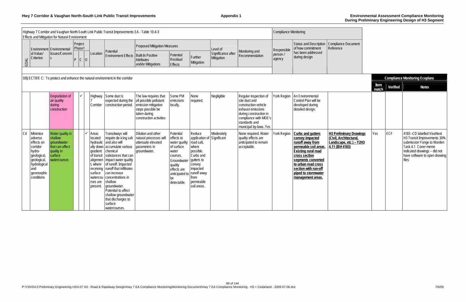
Hwy 7 Corridor & Vaughan North-South Link Public Transit Improvements Appendix 1 Environmental Assessment Compliance Monitoring During Preliminary Engineering Design of H3 Segment
89 of 144 P:\Y2H3\4.0 Preliminary Engineering H3\4.07 H3 - Road & Rapidway Design\Hwy 7 EA Compliance Monitoring\Monitoring Document\Hwy 7 EA Compliance Monitoring - H3 + Cedarland - 2009-07-06.doc 7/6/09
Highway 7 Corridor and Vaughan North-South Link Public Transit Improvements EA - Table 10.4-3 Effects and Mitigation for Natural Environment
Compliance Monitoring
Project Phase1
Proposed Mitigation Measures
GO
AL
Environmental Value/ Criterion
Environmental Issues/Concerns P C O
Location Potential Environment Effects Built-In Positive
Attributes and/or Mitigations
Potential Residual Effects
Further Mitigation
Level of Significance after Mitigation
Monitoring and Recommendation
Responsible person / agency
Status and Description of how commitment has been addressed during design
Compliance Document Reference
Compliance Monitoring Ecoplans OBJECTIVE C: To protect and enhance the natural environment in the corridor
Item match
Verified Notes
Degradation of air quality during construction
Highway 7 Corridor
Some dust is expected during the construction period.
The law requires that all possible pollutant emission mitigation steps possible be taken during construction activities
Some PM emissions locally.
None required.
Negligible Regular inspection of site dust and construction vehicle exhaust emissions during construction in compliance with MOE’s standards and municipal by-laws. Yes
York Region An Environmental Control Plan will be developed during detailed design.
C4 Minimize adverse effects on corridor hydro-geological, geological, hydrological and geomorphic conditions
Water quality in shallow groundwater that can affect quality in surface watercourses
Areas located hydraulically down gradient of transit alignment, where receiving surface watercourses are present.
Transitways will require de-icing salt and also will accumulate various chemical substances that can impact water quality of runoff. Impacted runoff that infiltrates can increase concentrations in shallow groundwater. Potential to affect shallow groundwater that discharges to surface watercourses.
Dilution and other natural processes will attenuate elevated parameters in groundwater.
Potential effects to water quality of surface water courses. Groundwater quality effects are anticipated to be detectable.
Reduce application of road salt, where possible. Curbs and gutters to convey impacted runoff away from permeable soil areas.
Moderately Significant
None required. Water quality effects are anticipated to remain acceptable.
York Region Curbs and gutters convey impacted runoff away from permeable soil areas. Existing rural road cross section segments converted to urban road cross section with run-off piped to stormwater management areas.
H3 Preliminary Drawings (Civil, Architectural, Landscape, etc.) – Y2H3 4.11 (ID# 4183)
Yes ECF 4183 -CD labelled VivaNext H3 Transit Improvements 30% submission Yonge to Warden Task 4.1 Cover memo indicated drawings – did not have software to open drawing files
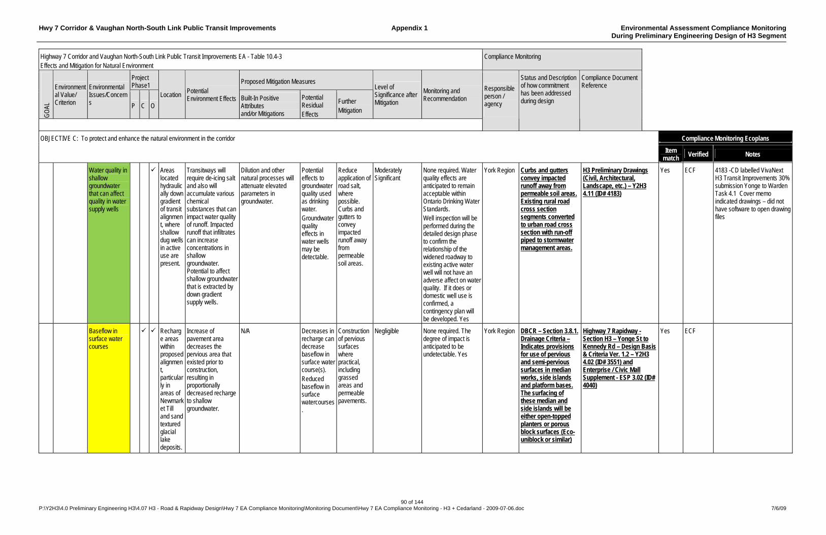
Hwy 7 Corridor & Vaughan North-South Link Public Transit Improvements Appendix 1 Environmental Assessment Compliance Monitoring During Preliminary Engineering Design of H3 Segment
90 of 144 P:\Y2H3\4.0 Preliminary Engineering H3\4.07 H3 - Road & Rapidway Design\Hwy 7 EA Compliance Monitoring\Monitoring Document\Hwy 7 EA Compliance Monitoring - H3 + Cedarland - 2009-07-06.doc 7/6/09
Highway 7 Corridor and Vaughan North-South Link Public Transit Improvements EA - Table 10.4-3 Effects and Mitigation for Natural Environment
Compliance Monitoring
Project Phase1
Proposed Mitigation Measures
GO
AL
Environmental Value/ Criterion
Environmental Issues/Concerns P C O
Location Potential Environment Effects Built-In Positive
Attributes and/or Mitigations
Potential Residual Effects
Further Mitigation
Level of Significance after Mitigation
Monitoring and Recommendation
Responsible person / agency
Status and Description of how commitment has been addressed during design
Compliance Document Reference
Compliance Monitoring Ecoplans OBJECTIVE C: To protect and enhance the natural environment in the corridor
Item match
Verified Notes
Water quality in shallow groundwater that can affect quality in water supply wells
Areas located hydraulically down gradient of transit alignment, where shallow dug wells in active use are present.
Transitways will require de-icing salt and also will accumulate various chemical substances that can impact water quality of runoff. Impacted runoff that infiltrates can increase concentrations in shallow groundwater. Potential to affect shallow groundwater that is extracted by down gradient supply wells.
Dilution and other natural processes will attenuate elevated parameters in groundwater.
Potential effects to groundwater quality used as drinking water. Groundwater quality effects in water wells may be detectable.
Reduce application of road salt, where possible. Curbs and gutters to convey impacted runoff away from permeable soil areas.
Moderately Significant
None required. Water quality effects are anticipated to remain acceptable within Ontario Drinking Water Standards. Well inspection will be performed during the detailed design phase to confirm the relationship of the widened roadway to existing active water well will not have an adverse affect on water quality. If it does or domestic well use is confirmed, a contingency plan will be developed. Yes
York Region Curbs and gutters convey impacted runoff away from permeable soil areas. Existing rural road cross section segments converted to urban road cross section with run-off piped to stormwater management areas.
H3 Preliminary Drawings (Civil, Architectural, Landscape, etc.) – Y2H3 4.11 (ID# 4183)
Yes ECF 4183 -CD labelled VivaNext H3 Transit Improvements 30% submission Yonge to Warden Task 4.1 Cover memo indicated drawings – did not have software to open drawing files
Baseflow in surface water courses
Recharge areas within proposed alignment, particularly in areas of Newmarket Till and sand textured glacial lake deposits.
Increase of pavement area decreases the pervious area that existed prior to construction, resulting in proportionally decreased recharge to shallow groundwater.
N/A Decreases in recharge can decrease baseflow in surface water course(s). Reduced baseflow in surface watercourses.
Construction of pervious surfaces where practical, including grassed areas and permeable pavements.
Negligible None required. The degree of impact is anticipated to be undetectable. Yes
York Region DBCR – Section 3.8.1. Drainage Criteria – Indicates provisions for use of pervious and semi-pervious surfaces in median works, side islands and platform bases. The surfacing of these median and side islands will be either open-topped planters or porous block surfaces (Eco-uniblock or similar)
Highway 7 Rapidway - Section H3 – Yonge St to Kennedy Rd – Design Basis & Criteria Ver. 1.2 – Y2H3 4.02 (ID# 3551) and Enterprise / Civic Mall Supplement - ESP 3.02 (ID# 4040)
Yes ECF

Hwy 7 Corridor & Vaughan North-South Link Public Transit Improvements Appendix 1 Environmental Assessment Compliance Monitoring During Preliminary Engineering Design of H3 Segment
91 of 144 P:\Y2H3\4.0 Preliminary Engineering H3\4.07 H3 - Road & Rapidway Design\Hwy 7 EA Compliance Monitoring\Monitoring Document\Hwy 7 EA Compliance Monitoring - H3 + Cedarland - 2009-07-06.doc 7/6/09
Highway 7 Corridor and Vaughan North-South Link Public Transit Improvements EA - Table 10.4-3 Effects and Mitigation for Natural Environment
Compliance Monitoring
Project Phase1
Proposed Mitigation Measures
GO
AL
Environmental Value/ Criterion
Environmental Issues/Concerns P C O
Location Potential Environment Effects Built-In Positive
Attributes and/or Mitigations
Potential Residual Effects
Further Mitigation
Level of Significance after Mitigation
Monitoring and Recommendation
Responsible person / agency
Status and Description of how commitment has been addressed during design
Compliance Document Reference
Compliance Monitoring Ecoplans OBJECTIVE C: To protect and enhance the natural environment in the corridor
Item match
Verified Notes
Increased pavement; decreased infiltration
Entire corridor
Minor increase in quantity of surface runoff. Minor decrease in quantity of groundwater.
Storm water management facilities such as grassed swales and storm water ponds.
Minor increase in peak streamflows. Minor decrease in groundwater.
None practical
Negligible None required Yes York Region A draft (SWMP) has been prepared during PE design as detailed in DBCR - Appendix H – Drainage & Hydrology Report Highway 7 Corridor (H3) – August 2008 - Sections 5.2 & 7. SWMP to be finalised in the detailed design phase.
Draft Drainage & Hydrology Report Highway 7 Corridor (H3) – Y2H3 4.05 (ID# 3230) - Hwy 404 to Kennedy report in progress.
Yes ECF
Changes in flood levels from the widening of existing bridges and culverts
Beaver Creek crossing at Sta 37+790
HEC-RAS model provided by TRCA was used to assess changes in flood level due to widening the existing culvert by 10 m.
No increase in Regional storm or return period flood levels upstream of the crossing. See Appendix G for results of the analysis.
N/A N/A Negligible None required. Yes York Region No action required during H3 PE Design
```` Rouge River (Apple Creek) crossing at Sta 38+695
HEC-RAS model provided by TRCA was used to assess changes in flood level due to widening the existing bridge by 18 m.
Regional storm flood level upstream of the bridge would increase by up to 50 mm. No increase in return period flood levels upstream of the crossing. See Appendix G for results of the analysis.
Minor increase in Regional storm flood level. Widening will not adversely impact upstream water levels.
N/A Negligible None required. Yes York Region No action required during H3 PE Design
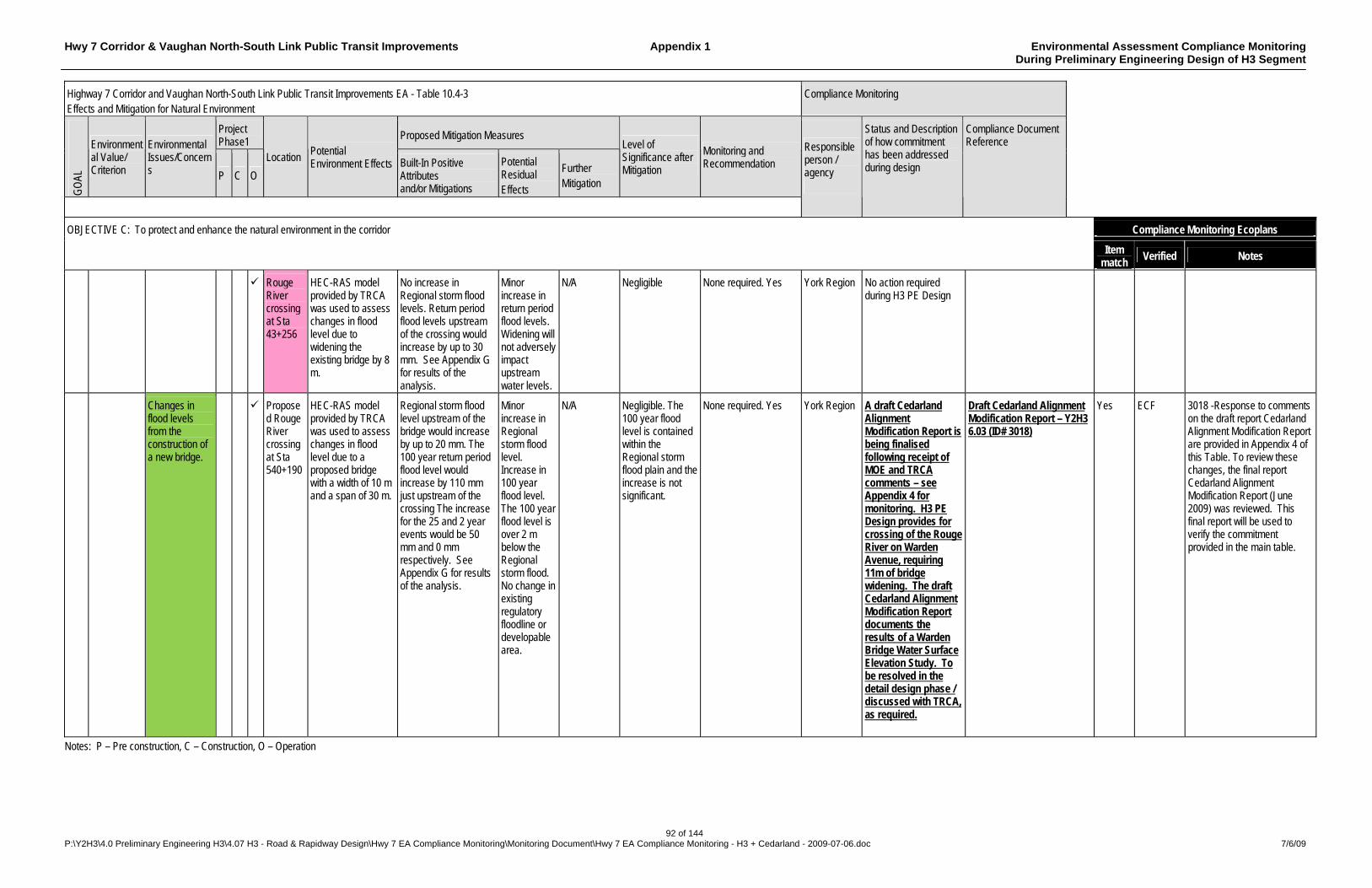
Hwy 7 Corridor & Vaughan North-South Link Public Transit Improvements Appendix 1 Environmental Assessment Compliance Monitoring During Preliminary Engineering Design of H3 Segment
92 of 144 P:\Y2H3\4.0 Preliminary Engineering H3\4.07 H3 - Road & Rapidway Design\Hwy 7 EA Compliance Monitoring\Monitoring Document\Hwy 7 EA Compliance Monitoring - H3 + Cedarland - 2009-07-06.doc 7/6/09
Highway 7 Corridor and Vaughan North-South Link Public Transit Improvements EA - Table 10.4-3 Effects and Mitigation for Natural Environment
Compliance Monitoring
Project Phase1
Proposed Mitigation Measures
GO
AL
Environmental Value/ Criterion
Environmental Issues/Concerns P C O
Location Potential Environment Effects Built-In Positive
Attributes and/or Mitigations
Potential Residual Effects
Further Mitigation
Level of Significance after Mitigation
Monitoring and Recommendation
Responsible person / agency
Status and Description of how commitment has been addressed during design
Compliance Document Reference
Compliance Monitoring Ecoplans OBJECTIVE C: To protect and enhance the natural environment in the corridor
Item match
Verified Notes
Rouge River crossing at Sta 43+256
HEC-RAS model provided by TRCA was used to assess changes in flood level due to widening the existing bridge by 8 m.
No increase in Regional storm flood levels. Return period flood levels upstream of the crossing would increase by up to 30 mm. See Appendix G for results of the analysis.
Minor increase in return period flood levels. Widening will not adversely impact upstream water levels.
N/A Negligible None required. Yes York Region No action required during H3 PE Design
Changes in flood levels from the construction of a new bridge.
Proposed Rouge River crossing at Sta 540+190
HEC-RAS model provided by TRCA was used to assess changes in flood level due to a proposed bridge with a width of 10 m and a span of 30 m.
Regional storm flood level upstream of the bridge would increase by up to 20 mm. The 100 year return period flood level would increase by 110 mm just upstream of the crossing The increase for the 25 and 2 year events would be 50 mm and 0 mm respectively. See Appendix G for results of the analysis.
Minor increase in Regional storm flood level. Increase in 100 year flood level. The 100 year flood level is over 2 m below the Regional storm flood. No change in existing regulatory floodline or developable area.
N/A Negligible. The 100 year flood level is contained within the Regional storm flood plain and the increase is not significant.
None required. Yes York Region A draft Cedarland Alignment Modification Report is being finalised following receipt of MOE and TRCA comments – see Appendix 4 for monitoring. H3 PE Design provides for crossing of the Rouge River on Warden Avenue, requiring 11m of bridge widening. The draft Cedarland Alignment Modification Report documents the results of a Warden Bridge Water Surface Elevation Study. To be resolved in the detail design phase / discussed with TRCA, as required.
Draft Cedarland Alignment Modification Report – Y2H3 6.03 (ID# 3018)
Yes ECF 3018 -Response to comments on the draft report Cedarland Alignment Modification Report are provided in Appendix 4 of this Table. To review these changes, the final report Cedarland Alignment Modification Report (June 2009) was reviewed. This final report will be used to verify the commitment provided in the main table.
Notes: P – Pre construction, C – Construction, O – Operation
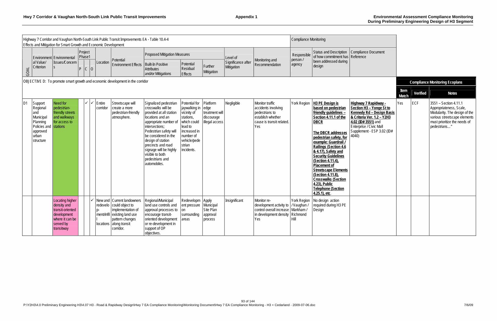
Hwy 7 Corridor & Vaughan North-South Link Public Transit Improvements Appendix 1 Environmental Assessment Compliance Monitoring During Preliminary Engineering Design of H3 Segment
93 of 144 P:\Y2H3\4.0 Preliminary Engineering H3\4.07 H3 - Road & Rapidway Design\Hwy 7 EA Compliance Monitoring\Monitoring Document\Hwy 7 EA Compliance Monitoring - H3 + Cedarland - 2009-07-06.doc 7/6/09
Highway 7 Corridor and Vaughan North-South Link Public Transit Improvements EA - Table 10.4-4 Effects and Mitigation for Smart Growth and Economic Development
Compliance Monitoring
Project Phase1
Proposed Mitigation Measures
GO
AL
Environmental Value/ Criterion
Environmental Issues/Concerns P C O
Location Potential Environment Effects Built-In Positive
Attributes and/or Mitigations
Potential Residual Effects
Further Mitigation
Level of Significance after Mitigation
Monitoring and Recommendation
Responsible person / agency
Status and Description of how commitment has been addressed during design
Compliance Document Reference
Compliance Monitoring Ecoplans OBJECTIVE D: To promote smart growth and economic development in the corridor
Item Match
Verified Notes
D1 Support Regional and Municipal Planning Policies and approved urban structure
Need for pedestrian-friendly streets and walkways for access to stations
Entire corridor
Streetscape will create a more pedestrian-friendly atmosphere.
Signalized pedestrian crosswalks will be provided at all station locations and an appropriate number of intersections; Pedestrian safety will be considered in the design of station precincts and road signage will be highly visible to both pedestrians and automobiles.
Potential for jaywalking in vicinity of stations, which could lead to increased in number of vehicle/pedestrian incidents.
Platform edge treatment will discourage illegal access
Negligible Monitor traffic accidents involving pedestrians to establish whether cause is transit related. Yes
York Region H3 PE Design is based on pedestrian friendly guidelines – Section 4.11.1 of the DBCR The DBCR addresses pedestrian safety, for example: Guardrail / Railings (Section 4.6 & 4.17), Safety and Security Guidelines (Section 4.11.4), Placement of Streetscape Elements (Section 4.11.8), Crosswalks (Section 4.23), Public Telephone (Section 4.25.1), etc.
Highway 7 Rapidway - Section H3 – Yonge St to Kennedy Rd – Design Basis & Criteria Ver. 1.2 – Y2H3 4.02 (ID# 3551) and Enterprise / Civic Mall Supplement - ESP 3.02 (ID# 4040)
Yes ECF 3551 – Section 4.11.1 Appropriateness, Scale, Modularity. The design of the various streetscape elements must prioritize the needs of pedestrians…”
Locating higher density and transit-oriented development where it can be served by transitway
New and redevelop-ment/infill locations
Current landowners could object to implementation of existing land use pattern changes along transit corridor.
Regional/Municipal land use controls and approval processes to encourage transit-oriented development or re-development in support of OP objectives.
Redevelopment pressure on surrounding areas
Apply Municipal Site Plan approval process
Insignificant Monitor re-development activity to control overall increase in development density Yes
York Region / Vaughan / Markham / Richmond Hill
No design action required during H3 PE Design

Hwy 7 Corridor & Vaughan North-South Link Public Transit Improvements Appendix 1 Environmental Assessment Compliance Monitoring During Preliminary Engineering Design of H3 Segment
94 of 144 P:\Y2H3\4.0 Preliminary Engineering H3\4.07 H3 - Road & Rapidway Design\Hwy 7 EA Compliance Monitoring\Monitoring Document\Hwy 7 EA Compliance Monitoring - H3 + Cedarland - 2009-07-06.doc 7/6/09
Highway 7 Corridor and Vaughan North-South Link Public Transit Improvements EA - Table 10.4-4 Effects and Mitigation for Smart Growth and Economic Development
Compliance Monitoring
Project Phase1
Proposed Mitigation Measures
GO
AL
Environmental Value/ Criterion
Environmental Issues/Concerns P C O
Location Potential Environment Effects Built-In Positive
Attributes and/or Mitigations
Potential Residual Effects
Further Mitigation
Level of Significance after Mitigation
Monitoring and Recommendation
Responsible person / agency
Status and Description of how commitment has been addressed during design
Compliance Document Reference
Compliance Monitoring Ecoplans OBJECTIVE D: To promote smart growth and economic development in the corridor
Item Match
Verified Notes
Reflection of historical districts through urban design and built form.
Main Street Markham
Station aesthetics may not be compatible with the character of heritage districts along the corridor.
In the area of Main Street, the rapid transit is discontinued with rapid transit operating in mixed traffic. Incorporate station designs and features that reflect the surrounding historical districts where further redevelopment is limited through consultation with community and heritage groups.
Historical district is generally north of Highway 7.
Apply Municipal Site plan approval process
Insignificant Municipalities to monitor nature of re-development in sensitive districts Yes
York Region / Markham
Not applicable to H3 PE Design
D2 Provide convenient access to social and community facilities in corridor
Potential barrier effects during construction and operation
Entire corridor
Transitway could be perceived as a barrier in access to future community centres, hospital(s), malls, parks, etc.
Construction Traffic and Pedestrian Management Plan will avoid wherever possible, barriers to entrances/exits to large attractors along Highway 7. Transitway median design will recognize pedestrian access requirements, particularly in proximity to community facilities.
Alternative access routes to facilities may affect adjacent properties
Mark detours and alternative access points clearly
Insignificant Monitor congestion levels during construction and traffic patterns during operations. Yes
York Region Construction Traffic and Pedestrian Management Plans will be developed during detailed design. Transitway design retains crossing opportunities at all existing crosswalk locations.
Highway 7 Rapidway - Section H3 – Yonge St to Kennedy Rd – Design Basis & Criteria Ver. 1.2 – Y2H3 4.02 (ID# 3551) and Enterprise / Civic Mall Supplement - ESP 3.02 (ID# 4040)
D3 Minimize adverse effects on business activities in corridor
The potential for an increase in business activity.
Entire corridor
Increased pedestrian traffic via the implementation of a rapid transit system will increased the potential for business activity.
A higher density of development on underutilized sites, infill locations and on vacant land should increase the market for some business activity.
Increase in vehicular traffic; increase in workforce/ population.
Encourage intensification meeting urban form objectives.
Insignificant and positive
Monitor building applications/ permits, economic influences (employment rate, etc.) Yes
York Region / Vaughan / Markham / Richmond Hill
No action required during H3 PE Design
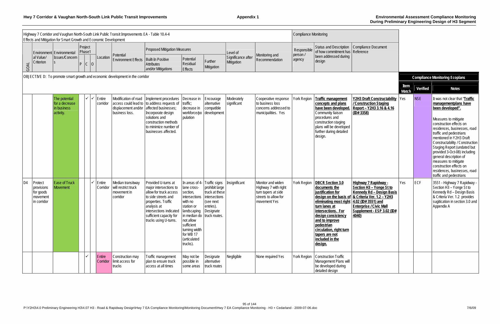
Hwy 7 Corridor & Vaughan North-South Link Public Transit Improvements Appendix 1 Environmental Assessment Compliance Monitoring During Preliminary Engineering Design of H3 Segment
95 of 144 P:\Y2H3\4.0 Preliminary Engineering H3\4.07 H3 - Road & Rapidway Design\Hwy 7 EA Compliance Monitoring\Monitoring Document\Hwy 7 EA Compliance Monitoring - H3 + Cedarland - 2009-07-06.doc 7/6/09
Highway 7 Corridor and Vaughan North-South Link Public Transit Improvements EA - Table 10.4-4 Effects and Mitigation for Smart Growth and Economic Development
Compliance Monitoring
Project Phase1
Proposed Mitigation Measures
GO
AL
Environmental Value/ Criterion
Environmental Issues/Concerns P C O
Location Potential Environment Effects Built-In Positive
Attributes and/or Mitigations
Potential Residual Effects
Further Mitigation
Level of Significance after Mitigation
Monitoring and Recommendation
Responsible person / agency
Status and Description of how commitment has been addressed during design
Compliance Document Reference
Compliance Monitoring Ecoplans OBJECTIVE D: To promote smart growth and economic development in the corridor
Item Match
Verified Notes
The potential for a decrease in business activity.
Entire corridor
Modification of road access could lead to displacement and/or business loss.
Implement procedures to address requests of affected businesses; Incorporate design solutions and construction methods to minimize number of businesses affected.
Decrease in traffic; decrease in workforce/population
Encourage alternative compatible development
Moderately significant
Cooperative response to business loss concerns addressed to municipalities. Yes
York Region Traffic management concepts and plans have been developed. Community liaison procedures and construction staging plans will be developed further during detailed design.
Y2H3 Draft Constructability / Construction Staging Report – Y2H3 3.16 & 4.16 (ID# 3358)
Yes NSE
It was not clear that “Traffic managementplans have been developed”. Measures to mitigate construction effects on residences, businesses, road traffic and pedestrians mentioned in Y2H3 Draft Constructability / Construction Staging Report (undated but provided 3-Oct-08) including general description of measures to mitigate construction effects on residences, businesses, road traffic and pedestrians
D4 Protect provisions for goods movement in corridor
Ease of Truck Movement
Entire Corridor
Median transitway will restrict truck movement in corridor
Provided U-turns at major intersections to allow for truck access to side streets and properties. Traffic analysis at intersections indicated sufficient capacity for trucks using U-turns.
In areas of 4-lane cross-section, intersections with no station or landscaping in median do not allow sufficient turning width for WB 17 (articulated trucks).
Traffic signs prohibit large truck at these intersections (see next entries). Designate truck routes.
Insignificant Monitor and widen Highway 7 with right turn tapers at side streets to allow for movement Yes
York Region DBCR Section 3.0 documents the justification for design on the basis of eliminating most right turn lanes at intersections. For design consistency and to improve pedestrian circulation, right turn tapers are not included in the design.
Highway 7 Rapidway - Section H3 – Yonge St to Kennedy Rd – Design Basis & Criteria Ver. 1.2 – Y2H3 4.02 (ID# 3551) and Enterprise / Civic Mall Supplement - ESP 3.02 (ID# 4040)
Yes ECF 3551 - Highway 7 Rapidway - Section H3 – Yonge St to Kennedy Rd – Design Basis & Criteria Ver. 1.2 provides sugitication in section 3.0 and Appendix A
Entire Corridor
Construction may limit access for trucks
Traffic management plan to ensure truck access at all times
May not be possible in some areas
Designate alternative truck routes
Negligible None required Yes York Region Construction Traffic Management Plans will be developed during detailed design
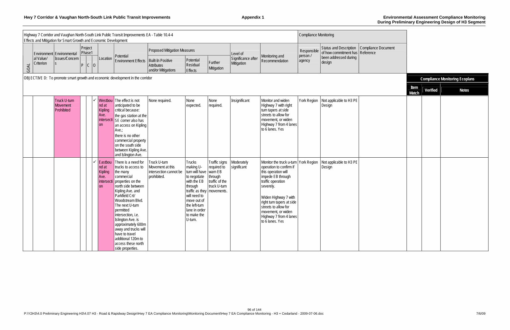
Hwy 7 Corridor & Vaughan North-South Link Public Transit Improvements Appendix 1 Environmental Assessment Compliance Monitoring During Preliminary Engineering Design of H3 Segment
96 of 144 P:\Y2H3\4.0 Preliminary Engineering H3\4.07 H3 - Road & Rapidway Design\Hwy 7 EA Compliance Monitoring\Monitoring Document\Hwy 7 EA Compliance Monitoring - H3 + Cedarland - 2009-07-06.doc 7/6/09
Highway 7 Corridor and Vaughan North-South Link Public Transit Improvements EA - Table 10.4-4 Effects and Mitigation for Smart Growth and Economic Development
Compliance Monitoring
Project Phase1
Proposed Mitigation Measures
GO
AL
Environmental Value/ Criterion
Environmental Issues/Concerns P C O
Location Potential Environment Effects Built-In Positive
Attributes and/or Mitigations
Potential Residual Effects
Further Mitigation
Level of Significance after Mitigation
Monitoring and Recommendation
Responsible person / agency
Status and Description of how commitment has been addressed during design
Compliance Document Reference
Compliance Monitoring Ecoplans OBJECTIVE D: To promote smart growth and economic development in the corridor
Item Match
Verified Notes
Truck U-turn Movement Prohibited
Westbound at Kipling Ave. intersection
The effect is not anticipated to be critical because: the gas station at the SE corner also has an access on Kipling Ave.; there is no other commercial property on the south side between Kipling Ave. and Islington Ave.
None required. None expected.
None required.
Insignificant Monitor and widen Highway 7 with right turn tapers at side streets to allow for movement, or widen Highway 7 from 4 lanes to 6 lanes. Yes
York Region Not applicable to H3 PE Design
Eastbound at Kipling Ave. intersection
There is a need for trucks to access to the many commercial properties on the north side between Kipling Ave. and Parkfield Crt/ Woodstream Blvd. The next U-turn permitted intersection, i.e. Islington Ave. is approximately 600m away and trucks will have to travel additional 120m to access these north side properties.
Truck U-turn Movement at this intersection cannot be prohibited.
Trucks making U-turn will have to negotiate with the EB through traffic as they will need to move out of the left-turn lane in order to make the U-turn.
Traffic signs required to warn EB through traffic of the truck U-turn movements.
Moderately significant
Monitor the truck u-turn operation to confirm if this operation will impede EB through traffic operation severely. Widen Highway 7 with right turn tapers at side streets to allow for movement, or widen Highway 7 from 4 lanes to 6 lanes. Yes
York Region Not applicable to H3 PE Design
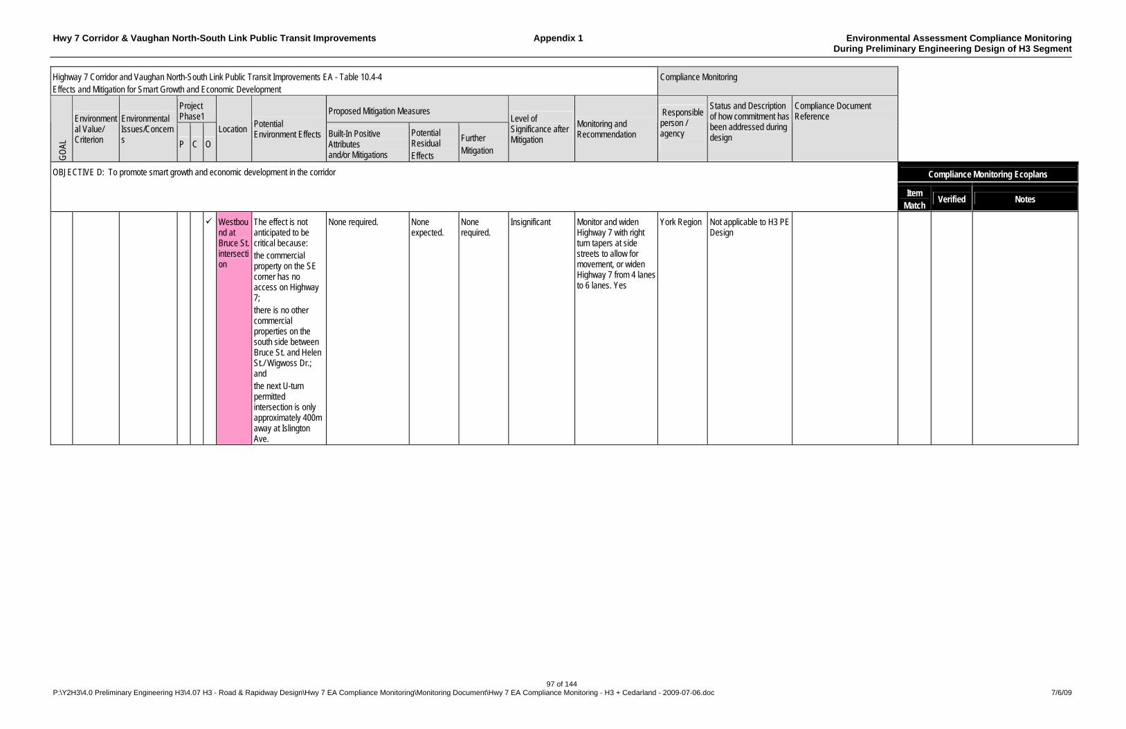
Hwy 7 Corridor & Vaughan North-South Link Public Transit Improvements Appendix 1 Environmental Assessment Compliance Monitoring During Preliminary Engineering Design of H3 Segment
97 of 144 P:\Y2H3\4.0 Preliminary Engineering H3\4.07 H3 - Road & Rapidway Design\Hwy 7 EA Compliance Monitoring\Monitoring Document\Hwy 7 EA Compliance Monitoring - H3 + Cedarland - 2009-07-06.doc 7/6/09
Highway 7 Corridor and Vaughan North-South Link Public Transit Improvements EA - Table 10.4-4 Effects and Mitigation for Smart Growth and Economic Development
Compliance Monitoring
Project Phase1
Proposed Mitigation Measures
GO
AL
Environmental Value/ Criterion
Environmental Issues/Concerns P C O
Location Potential Environment Effects Built-In Positive
Attributes and/or Mitigations
Potential Residual Effects
Further Mitigation
Level of Significance after Mitigation
Monitoring and Recommendation
Responsible person / agency
Status and Description of how commitment has been addressed during design
Compliance Document Reference
Compliance Monitoring Ecoplans OBJECTIVE D: To promote smart growth and economic development in the corridor
Item Match
Verified Notes
Westbound at Bruce St. intersection
The effect is not anticipated to be critical because: the commercial property on the SE corner has no access on Highway 7; there is no other commercial properties on the south side between Bruce St. and Helen St./ Wigwoss Dr.; and the next U-turn permitted intersection is only approximately 400m away at Islington Ave.
None required. None expected.
None required.
Insignificant Monitor and widen Highway 7 with right turn tapers at side streets to allow for movement, or widen Highway 7 from 4 lanes to 6 lanes. Yes
York Region Not applicable to H3 PE Design
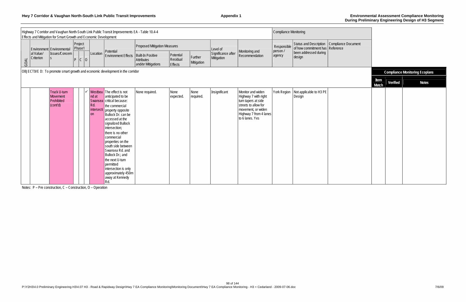
Hwy 7 Corridor & Vaughan North-South Link Public Transit Improvements Appendix 1 Environmental Assessment Compliance Monitoring During Preliminary Engineering Design of H3 Segment
98 of 144 P:\Y2H3\4.0 Preliminary Engineering H3\4.07 H3 - Road & Rapidway Design\Hwy 7 EA Compliance Monitoring\Monitoring Document\Hwy 7 EA Compliance Monitoring - H3 + Cedarland - 2009-07-06.doc 7/6/09
Highway 7 Corridor and Vaughan North-South Link Public Transit Improvements EA - Table 10.4-4 Effects and Mitigation for Smart Growth and Economic Development
Compliance Monitoring
Project Phase1
Proposed Mitigation Measures
GO
AL
Environmental Value/ Criterion
Environmental Issues/Concerns P C O
Location Potential Environment Effects Built-In Positive
Attributes and/or Mitigations
Potential Residual Effects
Further Mitigation
Level of Significance after Mitigation
Monitoring and Recommendation
Responsible person / agency
Status and Description of how commitment has been addressed during design
Compliance Document Reference
Compliance Monitoring Ecoplans OBJECTIVE D: To promote smart growth and economic development in the corridor
Item Match
Verified Notes
Truck U-turn Movement Prohibited (cont’d)
Westbound at Swansea Rd. intersection
The effect is not anticipated to be critical because: the commercial property opposite Bullock Dr. can be accessed at the signalized Bullock intersection; there is no other commercial properties on the south side between Swansea Rd. and Bullock Dr.; and the next U-turn permitted intersection is only approximately 450m away at Kennedy Rd.
None required. None expected.
None required.
Insignificant Monitor and widen Highway 7 with right turn tapers at side streets to allow for movement, or widen Highway 7 from 4 lanes to 6 lanes. Yes
York Region Not applicable to H3 PE Design
Notes: P – Pre construction, C – Construction, O – Operation
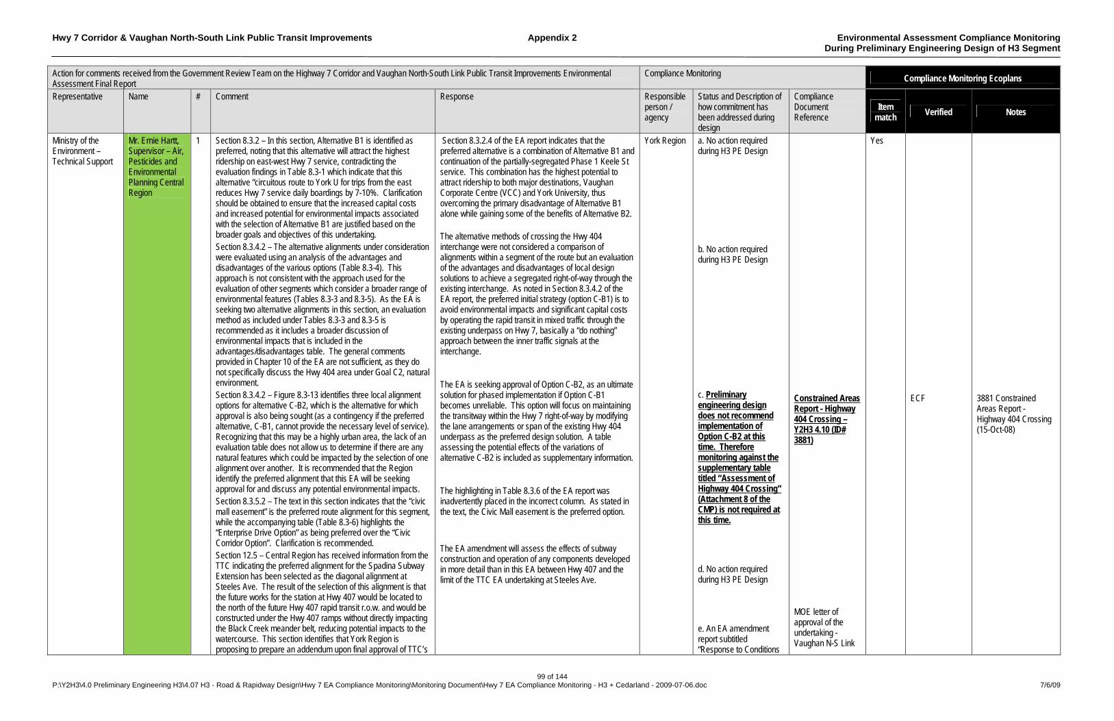
Hwy 7 Corridor & Vaughan North-South Link Public Transit Improvements Appendix 2 Environmental Assessment Compliance Monitoring During Preliminary Engineering Design of H3 Segment
99 of 144 P:\Y2H3\4.0 Preliminary Engineering H3\4.07 H3 - Road & Rapidway Design\Hwy 7 EA Compliance Monitoring\Monitoring Document\Hwy 7 EA Compliance Monitoring - H3 + Cedarland - 2009-07-06.doc 7/6/09
Action for comments received from the Government Review Team on the Highway 7 Corridor and Vaughan North-South Link Public Transit Improvements Environmental Assessment Final Report
Compliance Monitoring Compliance Monitoring Ecoplans
Representative Name # Comment Response Responsible person / agency
Status and Description of how commitment has been addressed during design
Compliance Document Reference
Item match
Verified Notes
Ministry of the Environment – Technical Support
Mr. Ernie Hartt, Supervisor – Air, Pesticides and Environmental Planning Central Region
1 Section 8.3.2 – In this section, Alternative B1 is identified as preferred, noting that this alternative will attract the highest ridership on east-west Hwy 7 service, contradicting the evaluation findings in Table 8.3-1 which indicate that this alternative “circuitous route to York U for trips from the east reduces Hwy 7 service daily boardings by 7-10%. Clarification should be obtained to ensure that the increased capital costs and increased potential for environmental impacts associated with the selection of Alternative B1 are justified based on the broader goals and objectives of this undertaking. Section 8.3.4.2 – The alternative alignments under consideration were evaluated using an analysis of the advantages and disadvantages of the various options (Table 8.3-4). This approach is not consistent with the approach used for the evaluation of other segments which consider a broader range of environmental features (Tables 8.3-3 and 8.3-5). As the EA is seeking two alternative alignments in this section, an evaluation method as included under Tables 8.3-3 and 8.3-5 is recommended as it includes a broader discussion of environmental impacts that is included in the advantages/disadvantages table. The general comments provided in Chapter 10 of the EA are not sufficient, as they do not specifically discuss the Hwy 404 area under Goal C2, natural environment. Section 8.3.4.2 – Figure 8.3-13 identifies three local alignment options for alternative C-B2, which is the alternative for which approval is also being sought (as a contingency if the preferred alternative, C-B1, cannot provide the necessary level of service). Recognizing that this may be a highly urban area, the lack of an evaluation table does not allow us to determine if there are any natural features which could be impacted by the selection of one alignment over another. It is recommended that the Region identify the preferred alignment that this EA will be seeking approval for and discuss any potential environmental impacts. Section 8.3.5.2 – The text in this section indicates that the “civic mall easement” is the preferred route alignment for this segment, while the accompanying table (Table 8.3-6) highlights the “Enterprise Drive Option” as being preferred over the “Civic Corridor Option”. Clarification is recommended. Section 12.5 – Central Region has received information from the TTC indicating the preferred alignment for the Spadina Subway Extension has been selected as the diagonal alignment at Steeles Ave. The result of the selection of this alignment is that the future works for the station at Hwy 407 would be located to the north of the future Hwy 407 rapid transit r.o.w. and would be constructed under the Hwy 407 ramps without directly impacting the Black Creek meander belt, reducing potential impacts to the watercourse. This section identifies that York Region is proposing to prepare an addendum upon final approval of TTC’s
Section 8.3.2.4 of the EA report indicates that the preferred alternative is a combination of Alternative B1 and continuation of the partially-segregated Phase 1 Keele St service. This combination has the highest potential to attract ridership to both major destinations, Vaughan Corporate Centre (VCC) and York University, thus overcoming the primary disadvantage of Alternative B1 alone while gaining some of the benefits of Alternative B2. The alternative methods of crossing the Hwy 404 interchange were not considered a comparison of alignments within a segment of the route but an evaluation of the advantages and disadvantages of local design solutions to achieve a segregated right-of-way through the existing interchange. As noted in Section 8.3.4.2 of the EA report, the preferred initial strategy (option C-B1) is to avoid environmental impacts and significant capital costs by operating the rapid transit in mixed traffic through the existing underpass on Hwy 7, basically a “do nothing” approach between the inner traffic signals at the interchange. The EA is seeking approval of Option C-B2, as an ultimate solution for phased implementation if Option C-B1 becomes unreliable. This option will focus on maintaining the transitway within the Hwy 7 right-of-way by modifying the lane arrangements or span of the existing Hwy 404 underpass as the preferred design solution. A table assessing the potential effects of the variations of alternative C-B2 is included as supplementary information. The highlighting in Table 8.3.6 of the EA report was inadvertently placed in the incorrect column. As stated in the text, the Civic Mall easement is the preferred option. The EA amendment will assess the effects of subway construction and operation of any components developed in more detail than in this EA between Hwy 407 and the limit of the TTC EA undertaking at Steeles Ave.
York Region a. No action required during H3 PE Design b. No action required during H3 PE Design c. Preliminary engineering design does not recommend implementation of Option C-B2 at this time. Therefore monitoring against the supplementary table titled “Assessment of Highway 404 Crossing” (Attachment 8 of the CMP) is not required at this time. d. No action required during H3 PE Design e. An EA amendment report subtitled “Response to Conditions
Constrained Areas Report - Highway 404 Crossing – Y2H3 4.10 (ID# 3881) MOE letter of approval of the undertaking - Vaughan N-S Link
Yes ECF
3881 Constrained Areas Report - Highway 404 Crossing (15-Oct-08)
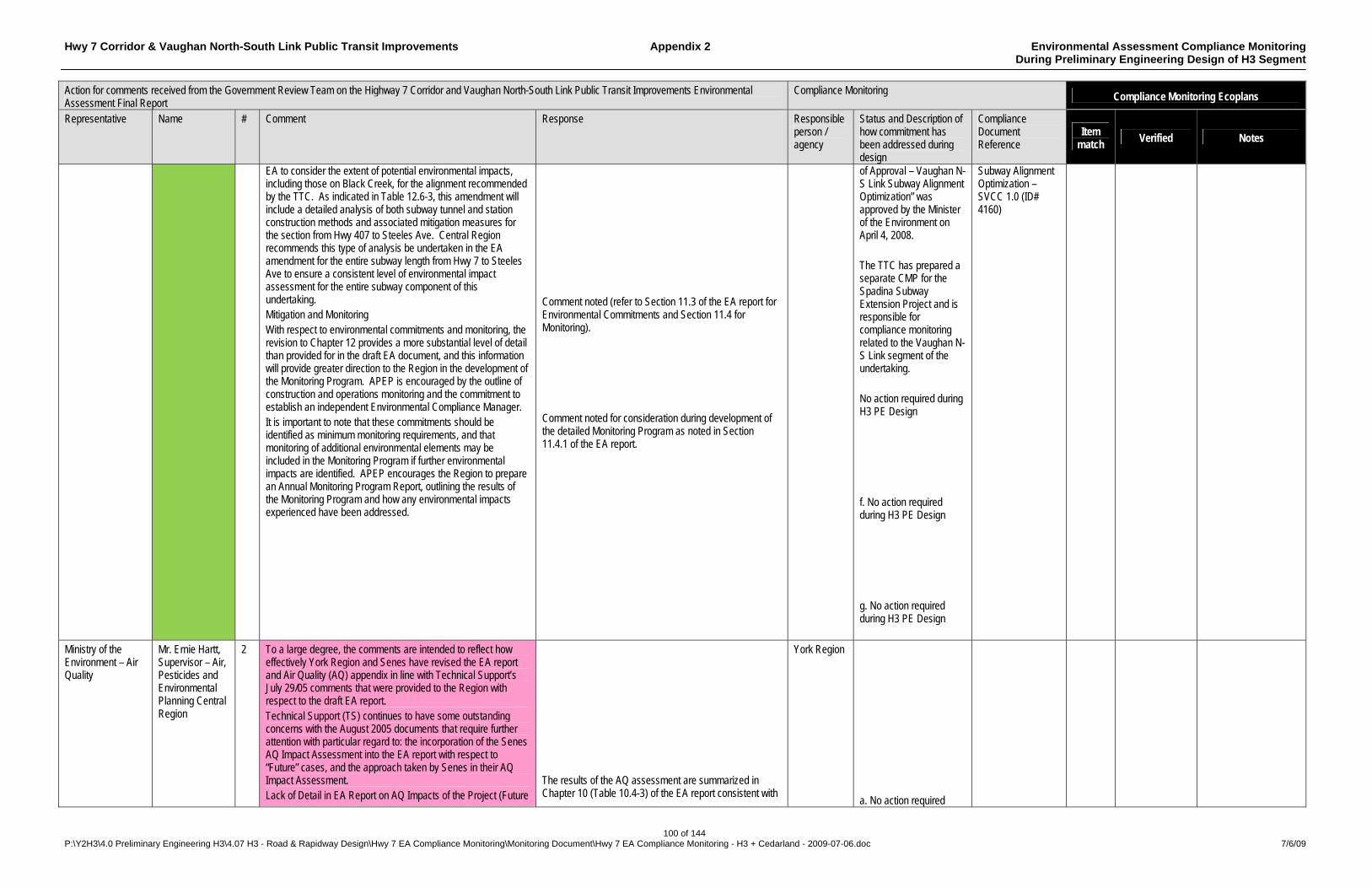
Hwy 7 Corridor & Vaughan North-South Link Public Transit Improvements Appendix 2 Environmental Assessment Compliance Monitoring During Preliminary Engineering Design of H3 Segment
100 of 144 P:\Y2H3\4.0 Preliminary Engineering H3\4.07 H3 - Road & Rapidway Design\Hwy 7 EA Compliance Monitoring\Monitoring Document\Hwy 7 EA Compliance Monitoring - H3 + Cedarland - 2009-07-06.doc 7/6/09
Action for comments received from the Government Review Team on the Highway 7 Corridor and Vaughan North-South Link Public Transit Improvements Environmental Assessment Final Report
Compliance Monitoring Compliance Monitoring Ecoplans
Representative Name # Comment Response Responsible person / agency
Status and Description of how commitment has been addressed during design
Compliance Document Reference
Item match
Verified Notes
EA to consider the extent of potential environmental impacts, including those on Black Creek, for the alignment recommended by the TTC. As indicated in Table 12.6-3, this amendment will include a detailed analysis of both subway tunnel and station construction methods and associated mitigation measures for the section from Hwy 407 to Steeles Ave. Central Region recommends this type of analysis be undertaken in the EA amendment for the entire subway length from Hwy 7 to Steeles Ave to ensure a consistent level of environmental impact assessment for the entire subway component of this undertaking. Mitigation and Monitoring With respect to environmental commitments and monitoring, the revision to Chapter 12 provides a more substantial level of detail than provided for in the draft EA document, and this information will provide greater direction to the Region in the development of the Monitoring Program. APEP is encouraged by the outline of construction and operations monitoring and the commitment to establish an independent Environmental Compliance Manager. It is important to note that these commitments should be identified as minimum monitoring requirements, and that monitoring of additional environmental elements may be included in the Monitoring Program if further environmental impacts are identified. APEP encourages the Region to prepare an Annual Monitoring Program Report, outlining the results of the Monitoring Program and how any environmental impacts experienced have been addressed.
Comment noted (refer to Section 11.3 of the EA report for Environmental Commitments and Section 11.4 for Monitoring). Comment noted for consideration during development of the detailed Monitoring Program as noted in Section 11.4.1 of the EA report.
of Approval – Vaughan N-S Link Subway Alignment Optimization” was approved by the Minister of the Environment on April 4, 2008. The TTC has prepared a separate CMP for the Spadina Subway Extension Project and is responsible for compliance monitoring related to the Vaughan N-S Link segment of the undertaking. No action required during H3 PE Design f. No action required during H3 PE Design g. No action required during H3 PE Design
Subway Alignment Optimization – SVCC 1.0 (ID# 4160)
Ministry of the Environment – Air Quality
Mr. Ernie Hartt, Supervisor – Air, Pesticides and Environmental Planning Central Region
2 To a large degree, the comments are intended to reflect how effectively York Region and Senes have revised the EA report and Air Quality (AQ) appendix in line with Technical Support’s July 29/05 comments that were provided to the Region with respect to the draft EA report. Technical Support (TS) continues to have some outstanding concerns with the August 2005 documents that require further attention with particular regard to: the incorporation of the Senes AQ Impact Assessment into the EA report with respect to “Future” cases, and the approach taken by Senes in their AQ Impact Assessment. Lack of Detail in EA Report on AQ Impacts of the Project (Future
The results of the AQ assessment are summarized in Chapter 10 (Table 10.4-3) of the EA report consistent with
York Region a. No action required
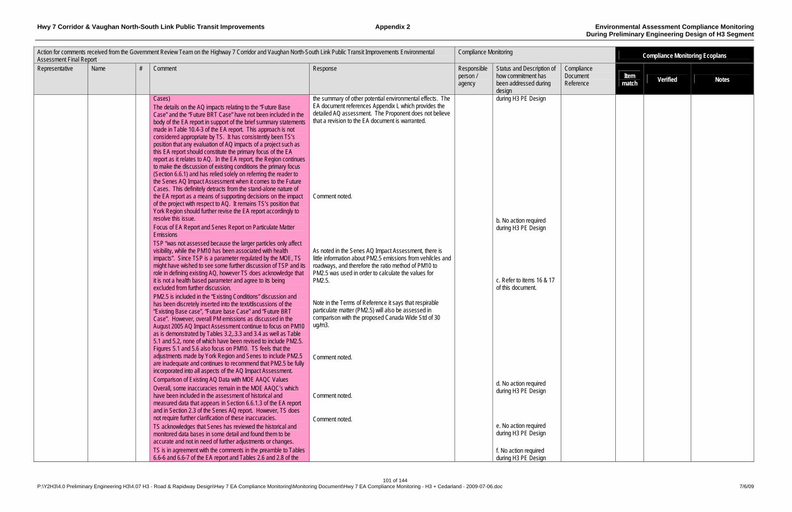
Hwy 7 Corridor & Vaughan North-South Link Public Transit Improvements Appendix 2 Environmental Assessment Compliance Monitoring During Preliminary Engineering Design of H3 Segment
101 of 144 P:\Y2H3\4.0 Preliminary Engineering H3\4.07 H3 - Road & Rapidway Design\Hwy 7 EA Compliance Monitoring\Monitoring Document\Hwy 7 EA Compliance Monitoring - H3 + Cedarland - 2009-07-06.doc 7/6/09
Action for comments received from the Government Review Team on the Highway 7 Corridor and Vaughan North-South Link Public Transit Improvements Environmental Assessment Final Report
Compliance Monitoring Compliance Monitoring Ecoplans
Representative Name # Comment Response Responsible person / agency
Status and Description of how commitment has been addressed during design
Compliance Document Reference
Item match
Verified Notes
Cases) The details on the AQ impacts relating to the “Future Base Case” and the “Future BRT Case” have not been included in the body of the EA report in support of the brief summary statements made in Table 10.4-3 of the EA report. This approach is not considered appropriate by TS. It has consistently been TS’s position that any evaluation of AQ impacts of a project such as this EA report should constitute the primary focus of the EA report as it relates to AQ. In the EA report, the Region continues to make the discussion of existing conditions the primary focus (Section 6.6.1) and has relied solely on referring the reader to the Senes AQ Impact Assessment when it comes to the Future Cases. This definitely detracts from the stand-alone nature of the EA report as a means of supporting decisions on the impact of the project with respect to AQ. It remains TS’s position that York Region should further revise the EA report accordingly to resolve this issue. Focus of EA Report and Senes Report on Particulate Matter Emissions TSP “was not assessed because the larger particles only affect visibility, while the PM10 has been associated with health impacts”. Since TSP is a parameter regulated by the MOE, TS might have wished to see some further discussion of TSP and its role in defining existing AQ, however TS does acknowledge that it is not a health based parameter and agree to its being excluded from further discussion. PM2.5 is included in the “Existing Conditions” discussion and has been discretely inserted into the text/discussions of the “Existing Base case”, “Future base Case” and “Future BRT Case”. However, overall PM emissions as discussed in the August 2005 AQ Impact Assessment continue to focus on PM10 as is demonstrated by Tables 3.2,.3.3 and 3.4 as well as Table 5.1 and 5.2, none of which have been revised to include PM2.5. Figures 5.1 and 5.6 also focus on PM10. TS feels that the adjustments made by York Region and Senes to include PM2.5 are inadequate and continues to recommend that PM2.5 be fully incorporated into all aspects of the AQ Impact Assessment. Comparison of Existing AQ Data with MOE AAQC Values Overall, some inaccuracies remain in the MOE AAQC’s which have been included in the assessment of historical and measured data that appears in Section 6.6.1.3 of the EA report and in Section 2.3 of the Senes AQ report. However, TS does not require further clarification of these inaccuracies. TS acknowledges that Senes has reviewed the historical and monitored data bases in some detail and found them to be accurate and not in need of further adjustments or changes. TS is in agreement with the comments in the preamble to Tables 6.6-6 and 6.6-7 of the EA report and Tables 2.6 and 2.8 of the
the summary of other potential environmental effects. The EA document references Appendix L which provides the detailed AQ assessment. The Proponent does not believe that a revision to the EA document is warranted. Comment noted. As noted in the Senes AQ Impact Assessment, there is little information about PM2.5 emissions from vehilcles and roadways, and therefore the ratio method of PM10 to PM2.5 was used in order to calculate the values for PM2.5. Note in the Terms of Reference it says that respirable particulate matter (PM2.5) will also be assessed in comparison with the proposed Canada Wide Std of 30 ug/m3. Comment noted. Comment noted. Comment noted.
during H3 PE Design b. No action required during H3 PE Design c. Refer to items 16 & 17 of this document. d. No action required during H3 PE Design e. No action required during H3 PE Design f. No action required during H3 PE Design
Hwy 7 Corridor & Vaughan North-South Link Public Transit Improvements Appendix 2 Environmental Assessment Compliance Monitoring During Preliminary Engineering Design of H3 Segment
102 of 144 P:\Y2H3\4.0 Preliminary Engineering H3\4.07 H3 - Road & Rapidway Design\Hwy 7 EA Compliance Monitoring\Monitoring Document\Hwy 7 EA Compliance Monitoring - H3 + Cedarland - 2009-07-06.doc 7/6/09
Action for comments received from the Government Review Team on the Highway 7 Corridor and Vaughan North-South Link Public Transit Improvements Environmental Assessment Final Report
Compliance Monitoring Compliance Monitoring Ecoplans
Representative Name # Comment Response Responsible person / agency
Status and Description of how commitment has been addressed during design
Compliance Document Reference
Item match
Verified Notes
Senes report that reflect PM as being the most significant parameter of concern with respect to both historical data and measured ambient monitoring data. The concerns identified with respect to PM (ie. PM10 and PM2.5) are to be dealt with in comments which follow in terms of dispersion modeling and mitigation. Development of Vehicle Emissions Data TS acknowledges that their concerns identified in the Vehicle Emissions data/discussion have been reviewed by York Region and dealt with satisfactorily. TS is in agreement that no further action is required on these concerns at this time. Dispersion Modeling/Assessment of Air Quality TS still has some concerns with respect to the representation of the project measurement/monitoring locations and the accuracy of the measurement/monitoring data collected during the somewhat limited program. TS however do not feet such concerns are significant and acknowledge that they will not change the overall conclusions of the AQ Impact Assessment. Matching of Alternatives Assessed in EA Report with Those Screened in the Senes Report The July 2004 Senes Report and the draft EA report did not clearly match-up in terms of the evaluation of alternatives noted in Section 8 of the EA report and the preliminary screening of alternatives dealt with in Section 3 of the Senes Report. To clarify this issue Senes removed Section 3 from their report. In order to clear up this matter, TS requests that York Region confirm that Senes’ approach on screening with respect to AQ did not provide any different result on selection of the preferred alternative from that shown in Section 8 of the final EA report. Identification of Mitigation Measures Section 9.1.1 of the EA report contains a statement noting the intent to plant trees as part of the landscaping plan and that “trees also act as a solid body for air pollutants to settle on and therefore reduce negative effects in the atmosphere”. TS would identify such efforts as tree planting as a factor in such mitigation and requests that they be considered by York Region and the appropriate revisions reflected in Table 10.4-3. Before any specific comment can be made on the implication of the landscaping plan, it is necessary to look at the AQ related statements in Table 10.4-3. The statement as noted under Proposed Mitigation Measures – Potential Residual Effects, suggests a 3.6% (it actually appears to be 1.6%) improvements (or decrease) in PM10 concentrations “when comparing 2021 (future) forecasts with (“Future BRT Case”) and without (“Future Base Case”) proposed rapid transit. The major difficulty that TS has with the conclusion on future PM10 concentrations (as noted above) is that it does not include consideration of Table 3.2, the existing base case pollutant concentration estimates. It is TS’s
Comment noted. Comment noted. The assessment of the effects of route segment alternatives on air quality, while a factor in the evaluation of natural environmental effects, did not provide any different result in the selection of the preferred alternatives from that shown in Section 8 of the EA report. A conceptual streetscape plan is identified in Section 9.1.1 of the EA report. A detailed streetscape plan will be developed during detailed design. It is acknowledged that tree planting provides an additional built-in positive effect on air quality. Tree planting will be considered further in the development in the detailed streetscape plan. The increase in PM (2001-2021) without the project is due solely to an increase in traffic volume. Without a change in the public’s attitude toward the use of single-occupancy vehicles this increase is unavoidable. The introduction of the BRT system will slow this increase. The EA report’s presentation of effects in 2021 is a true reflection of the conditions with and without the undertaking operating as a mature alternative transportation mode. The purpose of this undertaking is to provide an efficient alternative travel mode with the potential to reduce the growth in private automobile use and the consequent traffic volumes generated. Further mitigation to address the natural growth in trip-making in the Region’s major corridors is beyond the scope of this EA.
g. No action required during H3 PE Design h. No action required during H3 PE Design i. No action required during H3 PE Design j. The DBCR incorporates streetscaping recommendations: Streetscape Design Guidelines (Section 4.10), General Guidelines (Section 4.11), etc. Further attention will be given to the development of a streetscape plan in detailed design k. Refer to items 16 & 17 of this document
Highway 7 Rapidway - Section H3 – Yonge St to Kennedy Rd – Design Basis & Criteria Ver. 1.2 – Y2H3 4.02 (ID# 3551) and Enterprise / Civic Mall Supplement - ESP 3.02 (ID# 4040)

Hwy 7 Corridor & Vaughan North-South Link Public Transit Improvements Appendix 2 Environmental Assessment Compliance Monitoring During Preliminary Engineering Design of H3 Segment
103 of 144 P:\Y2H3\4.0 Preliminary Engineering H3\4.07 H3 - Road & Rapidway Design\Hwy 7 EA Compliance Monitoring\Monitoring Document\Hwy 7 EA Compliance Monitoring - H3 + Cedarland - 2009-07-06.doc 7/6/09
Action for comments received from the Government Review Team on the Highway 7 Corridor and Vaughan North-South Link Public Transit Improvements Environmental Assessment Final Report
Compliance Monitoring Compliance Monitoring Ecoplans
Representative Name # Comment Response Responsible person / agency
Status and Description of how commitment has been addressed during design
Compliance Document Reference
Item match
Verified Notes
opinion to include consideration of the fact that PM10 emissions will increase markedly from the existing base case to the future base case. As a result there will be a 38% increase in PM10 initially and it will decrease 1.6% with inclusion of BRT. For York Region to then conclude that the focus should be only on 2021 is misleading and not something we can easily agree to. At the very least TS feels that this change over the period 2001 to 2021 could be characterized in terms of BRT “slowing” the increase but it should in TS’s opinion include consideration of “Further Mitigation” based on significant initial increase in PM10 concentrations. The reference for the statement in k above is data noted as being available in Tables 4.3 and 4.4 of the Senes Report, when in fact it should be Tables 3.3 and 3.4. In light of comments b and c, it is TS’s opinion that the issue of PM2.5 concentrations also needs further review and as such, Table 10.4-3 should be modified to include consideration of PM2.5 as well as PM10. Monitoring of Construction PM Emissions Table 10.4-3 of the EA report includes comments on “Degradation of air quality during construction: which indicates that “some PM emissions locally” are expected but no “Monitoring” is recommended. This information raises some concern with TS about its compatibility with information provided in Section 11.4.1 of the EA report, which does indicate that “Monitoring” will be done in the form of regular inspections of dust and vehicular emissions control. Table 11.4-1 of the EA report does provide some qualitative comment on “Monitoring” associated with “effect of construction activities on air quality (dust, odour).” TS strongly in favour of the need to do such monitoring and requests that York Region clarify what appears to be contrary statements in table 10.4-3 that no “Monitoring” is recommended. Senes Project Description The content of Section 1.1 of the Senes report has been reasonably clarified with the addition of explanatory paragraph. Executive Summaries Both the EA report and the Senes report executive summaries need further review in order to substantiate that they are compatible with changes to the bodies of the reports as may occur in terms of addressing the comments provided by TS and noted in the memo. Overall Assessment of Air Quality The Overall Assessment as noted in Section 8 of the Senes report and quoted in the EA report needs further review in order to substantiate that they are compatible with changes to the bodies of the reports as may occur in terms of addressing the comments provided by TS and noted in the memo.
Comment noted. Table 10.4-3 of the EA report should refer to Tables 3.3 and 3.4 of the Senes AQ report, and not Tables 4.3 and 4.4. There will be a net positive effect to the environment from PM2.5 and PM10, therefore no further mitigation is required. Table 10.4-3 of the EA report was intended to indicate that no specific monitoring program beyond that normally required by the construction contract conditions is recommended. The Region will enforce the requirements of the standard contract conditions as described in Section 11.4.1 of the EA report. Comment noted. There are no changes proposed to the main EA report to address comments provided by TS. Clarification will be provided as appropriate. There are no changes proposed to the main EA report to address comments provided by TS. Clarification will be provided as appropriate.
l. No action required during H3 PE Design m. Refer to items 16 & 17 of this document n. No action required during H3 PE Design o. No action required during H3 PE Design p. No action required during H3 PE Design
Hwy 7 Corridor & Vaughan North-South Link Public Transit Improvements Appendix 2 Environmental Assessment Compliance Monitoring During Preliminary Engineering Design of H3 Segment
104 of 144 P:\Y2H3\4.0 Preliminary Engineering H3\4.07 H3 - Road & Rapidway Design\Hwy 7 EA Compliance Monitoring\Monitoring Document\Hwy 7 EA Compliance Monitoring - H3 + Cedarland - 2009-07-06.doc 7/6/09
Action for comments received from the Government Review Team on the Highway 7 Corridor and Vaughan North-South Link Public Transit Improvements Environmental Assessment Final Report
Compliance Monitoring Compliance Monitoring Ecoplans
Representative Name # Comment Response Responsible person / agency
Status and Description of how commitment has been addressed during design
Compliance Document Reference
Item match
Verified Notes
q. No action required during H3 PE Design
Ministry of the Environment – Water Resources
Ms. Ellen Schmarje, Supervisor, Water Resources Unit, Central Region – Technical Support Section
3 In reference to the definitions of “Insignificant” and “Significant” in Section 10.1: Assessment Methodology, an effect that is temporary or short term in duration may be considered significant as the release of suspended solids to a watercourse can potentially cause a permanent loss of critical or productive aquatic habitat. The Proponent should note that Section 53 (OWRA) approvals from the MOE will be required for the new and expanded storm sewers and end-of-pipe stormwater management facilities prior to the construction phase (Section 11.2: Project Implementation Plan). A permit to take water must be obtained for all dewatering activities in excess of 50,000 L/day. The permit must be obtained prior to the commencement of any construction related activities requiring groundwater dewatering (Section 11.2: Project Implementation Plan). Table 11.3 indicates that “in the event a shallow or upward groundwater movement becomes an issue due to construction of the subway during the detailed design stage, TRCA’s hydrogeologist will be consulted.” It is important to note, that any groundwater issues (including dewatering or water quality issues) related to the proposed undertaking must be dealt directly with the MOE, which may consult with TRCA if necessary. No major outstanding surface water or groundwater issues were identified regarding the preferred alternative. Additional input during the detailed design phase may be required to ensure that monitoring, mitigation and contingency plans adequately assess any adverse impacts to the natural environment and/or sufficiently protect the natural environment.
Comment noted. As described in Section 10.1 of the EA report, the definition of significant effect includes a permanent loss of critical or productive aquatic habitat, regardless of the duration of the original net effect that precipitates the permanent effect. Comment noted and will be carried forward for consideration during detailed design. Section 11.2.1 of the EA report identifies examples of other approvals that may be required during the detailed design phase, but is not intended as a complete list of all post EA approvals that will be required. Comment noted and will be considered during both the preparation of the EA amendment for the southern portion and during detailed design of the entire undertaking. Comment noted. The MOE and TRCA will be consulted accordingly during detailed design. Comment noted. The MOE will be consulted during development of the detailed Monitoring Program as appropriate.
York Region a. No action required during H3 PE Design b. No action required during H3 PE Design c. No action required during H3 PE Design d. To be addressed during design and construction of the Spadina Subway Extension, covered under a separate CMP. e. A draft (SWMP) has been prepared during PE design as detailed in DBCR - Appendix H – Drainage & Hydrology Report Highway 7 Corridor (H3) – August 2008 - Sections 5.2 & 7. Section 6.0 of the Drainage & Hydrology Report proposes corresponding mitigation measures for an Environmental Control Plan, which will be developed during detailed design.
Draft Drainage & Hydrology Report Highway 7 Corridor (H3) – Y2H3 4.05 (ID# 3230) - Hwy 404 to Kennedy report in progress.
Hwy 7 Corridor & Vaughan North-South Link Public Transit Improvements Appendix 2 Environmental Assessment Compliance Monitoring During Preliminary Engineering Design of H3 Segment
105 of 144 P:\Y2H3\4.0 Preliminary Engineering H3\4.07 H3 - Road & Rapidway Design\Hwy 7 EA Compliance Monitoring\Monitoring Document\Hwy 7 EA Compliance Monitoring - H3 + Cedarland - 2009-07-06.doc 7/6/09
Action for comments received from the Government Review Team on the Highway 7 Corridor and Vaughan North-South Link Public Transit Improvements Environmental Assessment Final Report
Compliance Monitoring Compliance Monitoring Ecoplans
Representative Name # Comment Response Responsible person / agency
Status and Description of how commitment has been addressed during design
Compliance Document Reference
Item match
Verified Notes
Ministry of the Environment – Air and Noise Unit
Mr. Denton Miller 4 Noise With respect to Section 5 of Appendix K, there were several errors noted in the assessment of the 2021 baseline, BRT and LRT noise calculations. Some of the errors cancelled other errors and it is unlikely that the actual impact will change the overall conclusions drawn in Appendix K. Nonetheless the errors should be corrected. Surface Type Used in Stamson Calculations The majority of the calculations in Appendix K are based on absorptive ground surfaces. Based on drawings submitted with the proposal, it is the Air and Noise Unit’s opinion that ground absorption was used incorrectly in the assessment of the roadway. The Proponent should revise the subject calculations accordingly or clarify why this approach was used. Daytime and Nighttime Receiver Heights Used in Stamson Calculations The receiver heights used in the assessment of the receptors are not consistent with Section 5.5.4 of the MOE’s publication ornament where it is stated that for the purposes of assessing the noise impact on single family dwellings and townhouse units, the following receiver heights are used: 1.5 m for defining the outdoor living area, and 4.5 m for defining a 2nd storey window. The proponent should revise the subject calculations accordingly or clarify why this approach is used. Nighttime Receiver Source Distances Used in Stamson Calculations When homes are backing onto the subject roadway, the daytime source receiver distance should not be equal to the nighttime source receiver distance. The daytime distances should address the sound levels in the outdoor living area (backyard), and the nighttime distance should address the sound levels at the plane of a bedroom window. In the majority of cases the two distances should differ by 3m. This was not the case in the assessments in Appendix K. The Proponent should revise the subject calculations accordingly or clarify why this approach was
Please refer to the attached Noise and Vibration Supplementary Information package for revised tables and appendices to Appendix K – Noise and Vibration impact Assessment, of the EA report. Refer to responses below. As shown in the revised data attached, the conclusions drawn in the original report are still valid. In all cases where noise monitoring was conducted (receptors) the intermediate surface was covered by grass and therefore it was determined that an absorptive designation was appropriate. ORNAMENT Technical Document (MOE 1989), states that “Soft ground surfaces such as ploughed fields, or ground covered with grass, shrubs, or other forms of vegetation are considered to be sound absorptive”. This is also reflected in the monitoring results. The predicted sound levels for existing conditions (2002) (section 4.0 in Appendix K) closely resemble the measured sound levels. To be consistent in the modeling approach, the absorptive surface was also used in the prediction of noise level for future cases. However, in light of the above comment b, the noise modeling was revised using a reflective ground surface. The predicted sound levels were found to be still within the range of the measured results in most instances. Therefore, all scenarios have been revised using a reflective ground surface and are attached for review. The purpose of Section 4.3 in Appendix K is to compare the predicted sound level (from traffic) with the existing sound levels using noise monitoring data collected at specific receptors along the route. For this purpose only, the actual height of the microphone of the noise monitoring equipment was used for a direct comparison with the traffic passby at each specific receptor location. However, for predicting future noise impact the noise modeling was carried out using 1.5 m for outdoor living area and 4.5 m for a 2nd story window. The shorter of the two horizontal distances was conservatively used for both daytime and nighttime. In any case, the 3 m difference does not result in a significant/noticeable difference in the predicted sound levels. However, the nighttime receptor distances used in the revised model have been changed to reflect the 3 m difference. Refer to the attached STAMSON sheets.
York Region a. No action required during H3 PE Design b. No action required during H3 PE Design c. No action required during H3 PE Design d. No action required during H3 PE Design
Hwy 7 Corridor & Vaughan North-South Link Public Transit Improvements Appendix 2 Environmental Assessment Compliance Monitoring During Preliminary Engineering Design of H3 Segment
106 of 144 P:\Y2H3\4.0 Preliminary Engineering H3\4.07 H3 - Road & Rapidway Design\Hwy 7 EA Compliance Monitoring\Monitoring Document\Hwy 7 EA Compliance Monitoring - H3 + Cedarland - 2009-07-06.doc 7/6/09
Action for comments received from the Government Review Team on the Highway 7 Corridor and Vaughan North-South Link Public Transit Improvements Environmental Assessment Final Report
Compliance Monitoring Compliance Monitoring Ecoplans
Representative Name # Comment Response Responsible person / agency
Status and Description of how commitment has been addressed during design
Compliance Document Reference
Item match
Verified Notes
used. Percent Traffic Split of Provincial Roadways that should be used in Stamson Calculations The recommended day-night traffic volume ratios are 85%-15% for provincial roads. Hwy 7 is a provincial roadway. Clarification is required as to why the appropriate traffic split was not used in the assessment or the calculations should be adjusted accordingly. Designation of Buses in Stamson Calculations As noted in the MOE’s publication ornament, buses are considered to be medium trucks, hence the percentage of medium trucks should not be the same in Appendices K-D (Predicted 2021 Baseline Traffic Noise Levels) and K-E (Sound Levels Due to Added Bus Transit Traffic). The Proponent should revise the subject calculations accordingly or clarify why this approach was used. AADT Inconsistencies Section 5.2 of Appendix K (Scenario 2 – Bus Transit Option), states that “Scenario 2 predicts the sound levels on the same road segments for the same year (2021), but with the added influence of the bus transit traffic”. However the AADT in Appendix K-E (54,144; Sound Levels Due to Added Bus Transit Traffic) is lower that the AADT in Appendix K-D (54,528; Predicted 2021 Baseline Traffic Noise Levels). The proponent should revise the subject calculations accordingly or clarify why this approach was used. Distances in Stamson Calculations Some of the distances in the assessment of the proposal are not correct. For example, the distance to the centre of the eastbound segment of the roadway is 28.6 m. This is clearly not correct when assessed against Figure 9.7 of the EA report. The proponent should revise the subject calculations accordingly or clarify why this approach was used. LRT Assessment The above concerns are for the most part also applicable to the assessment of the proposed LRT. The Proponent should revise the subject calculations accordingly or clarify why this approach was used. Preferred Assessment Methodology The preferred assessment would see the dedicated bus lanes and the LRT, defined as separate segments in Stamson. This approach would simplify the Proponent’s assessment and our review of the undertaking. Vibration Reference Vibration Value
The 90%-10% day-night traffic volume ratio used in the modeling was derived from traffic count data and adopted as an appropriate representation of conditions on Highway 7 in the study area. The added bus transit traffic was treated as an RT/Custom source for the STAMSON modeling, that is, a separate source from the regular traffic. Also, the traffic volume of bus transit was not included in the AADT volume for the regular traffic. Hence the percentage of medium trucks is indeed the same in Appendices K-D and K-E. The actual noise level for the bus transit was provided by the manufacturer. The data used were generated by the travel demand modeling with the model calibrated against York Region’s most recent AADT counts for Highway 7. The AADT figure for the “with BRT” scenario represents general traffic only and does not include the BRT vehicles themselves. The modeling projects a minor reduction in auto vehicle use after BRT implementation however the overall person-capacity of the roadway is increased by the carrying capacity of the BRT service. The distances have been revised to reflect those shown in the figures in Chapter 9 of the EA report. Refer to the attached STAMSON sheets. The distances have been revised to reflect those shown in the figures in Chapter 9 of the EA report. Refer to the attached STAMSON sheets. The recommended assessment methodology as suggested by the MOE was used in the study submitted. The bus transit and LRT were treated as a separate segment in the Stamson modeling. Please refer to Appendix K-E and Appendix K-F. This issue had been previously responded to and discussed with Mr. Denton Miller of the MOE Noise Unit in June 2005. Please see the revised Table 6.1 attached.
e. No action required during H3 PE Design f. No action required during H3 PE Design g. No action required during H3 PE Design h. No action required during H3 PE Design i. No action required during H3 PE Design j. No action required during H3 PE Design k. No action required
Hwy 7 Corridor & Vaughan North-South Link Public Transit Improvements Appendix 2 Environmental Assessment Compliance Monitoring During Preliminary Engineering Design of H3 Segment
107 of 144 P:\Y2H3\4.0 Preliminary Engineering H3\4.07 H3 - Road & Rapidway Design\Hwy 7 EA Compliance Monitoring\Monitoring Document\Hwy 7 EA Compliance Monitoring - H3 + Cedarland - 2009-07-06.doc 7/6/09
Action for comments received from the Government Review Team on the Highway 7 Corridor and Vaughan North-South Link Public Transit Improvements Environmental Assessment Final Report
Compliance Monitoring Compliance Monitoring Ecoplans
Representative Name # Comment Response Responsible person / agency
Status and Description of how commitment has been addressed during design
Compliance Document Reference
Item match
Verified Notes
Confirm that the reference value for the vibration calculations in Section 6.1 of Appendix K is 1 micro-metre per second. If correct, please provide a detailed sample calculation of the results noted in Table 6.1. If incorrect please comment on the use of an appropriate reference value and the impact it will have on the calculations and the subsequent conclusions.
during H3 PE Design
Ministry of the Environment
Ms. Gemma Connolly, Special Project Officer
5 CEAA Approval Page 1-1 identifies that approval under the Canadian Environmental Assessment Act is being sought through an integral parallel process. No federal trigger was identified by CEAA through their review of the provincial EA. Therefore, EAAB is unaware of any coordinated and/or concurrent federal approval process. Chapter 8 Evaluation Local Alignment Options It is difficult to follow the evaluation methodology used to select the preferred local alignment options. This analysis is identified in Tables 8.3.-3 to 8.3-7. Table 8.3-5 identifies Option C3-4 as the preferred option and Option C3-3 as the next preferred. It is unclear how these options were ranked and evaluated. Table 8.3-6 highlights Enterprise Dr as the preferred option, while the text identifies Civic Corridor as the preferred option. Qualitative rankings are provided in Table 8.3-6 indicating fair, good but no rationale is provided on what this means in the weighing of the criteria. Table 8.3-7 provides check marks with no rationale on what these mean. Please provide further clarification on how these local alignment options were assessed and evaluated.
Given that federal funding has not yet been approved, it is anticipated that the only likely trigger will be the DFO’s approval of the major river crossings. The Region expects that this local approval will be obtained through DFO’s delegation of authority to the TRCA. Generally, where applicable, these options were evaluated using the major objectives adopted for the primary route alternatives analysis. In some cases, such as the Markham Centre/Enterprise Dr area, more specific local factors were used to compare options. The table presents the basis for the evaluation of the options by listing the key attributes or effects of each option in terms of the goals and primary objectives adopted for evaluation of the larger route segments along the corridor. Each option’s performance against the goals was assessed by evaluating the individual attributes/effects to identify the preferred option in terms of each of the five main objectives. Options C3-3 and C3-4 were selected from this initial screening. The relative merits of these two options were discussed in the text supporting the evaluation table in Section 8.1.5.1. This comparison indicates that Option C3-4 is cost-effective and would provide the most convenient access to rapid transit for several trip types and destinations. At the same time the design of the new Rouge crossing to meet TRCA requirements will mitigate adverse effects on the natural environment. In Table 8.3-6, the Enterprise Drive option was inadvertently highlighted as the “Technically Preferred Option”. The qualitative rankings shown against each indicator were assessed collectively with implicit weighting and found to support the conclusion in the text that the Civic Mall Option best met the objectives for improved transit service through the planned Markham Centre. Each check mark in Table 8.3-7 indicates the alignment alternative (Option C-C1 or C-C2) that is preferred in terms of the individual planning criteria noted in the table. For some criteria, both options were considered to be equally responsive and thus both were checked. Again, these responses were assessed collectively leading to the
York Region a. DFO’s approval of the major river crossings will be obtained during detail design. b. No action required during H3 PE Design c. No action required during H3 PE Design d. No action required during H3 PE Design e. No action required during H3 PE Design
Hwy 7 Corridor & Vaughan North-South Link Public Transit Improvements Appendix 2 Environmental Assessment Compliance Monitoring During Preliminary Engineering Design of H3 Segment
108 of 144 P:\Y2H3\4.0 Preliminary Engineering H3\4.07 H3 - Road & Rapidway Design\Hwy 7 EA Compliance Monitoring\Monitoring Document\Hwy 7 EA Compliance Monitoring - H3 + Cedarland - 2009-07-06.doc 7/6/09
Action for comments received from the Government Review Team on the Highway 7 Corridor and Vaughan North-South Link Public Transit Improvements Environmental Assessment Final Report
Compliance Monitoring Compliance Monitoring Ecoplans
Representative Name # Comment Response Responsible person / agency
Status and Description of how commitment has been addressed during design
Compliance Document Reference
Item match
Verified Notes
Section 8.3.4.2 is seeking approval for both C-B1 and C-B2. The preferred option is identified as C-B1. Any proposed changes to the preferred option would be considered an amendment to the undertaking. Intermodal Stations The York Region intermodal terminal and Richmond Hill intermodal terminal are discussed as part of the undertaking on page 9-2. These stations are not supposed to be part of this EA approval and should not be described as part of the approved undertaking. Missing Information Please provide the missing information in Table 10.4-2 on page 10-9. Effects and Mitigation On Table 10.4-2 some issues are evaluated as “Significant” after mitigation, yet monitoring is not recommended. Could you please justify why monitoring will not occur? Vaughan North-South Link Ultimate Conversion to Subway Technology
recommendation of the northern alignment stated in the text. The alternative methods of crossing the Hwy 404 interchange were not considered a comparison of alignments within a segment of the route but an evaluation of the advantages and disadvantages of local design solutions to achieve a segregated right-of-way through the existing interchange. As noted in Section 8.3.4.2 of the EA report, the preferred strategy (option C-B1) is to avoid environmental impacts and significant capital costs by operating the rapid transit in mixed traffic through the existing underpass on Hwy 7, basically a “do nothing” solution. The Region is seeking approval of Option C-B2, as the preferred ultimate solution for phased implementation if Option C-B1 becomes unreliable. This option will focus on maintaining the transitway within the Hwy 7 right-of-way by modifying the lane arrangements or span of the existing Hwy 404 underpass as the preferred design solution. A supplementary table assessing the potential effects of the three variations of alternative C-B2 is attached. Option C-B2, grade separated right-of-way, will be the Region’s preferred ultimate option if and when required to traverse the Hwy 404 interchange without congestion delays. Option C-B1, operation of the transitway in mixed traffic, will be used until such time congestion problems trigger the need for the grade separation Option C-B2. Improvements to the road system, currently planned by the municipalities will also influence the timing of and need for the ultimate grade separated right-of-way (C-B2). Comment noted. These terminals were mentioned as examples of associated facilities in the context of inter-connectivity with other modes. A completed page 10-9 of Table 10.4-2 from the EA report is provided as supplementary information. The issues identified as significant after mitigation are those concerning intersection levels of service analyzed as near or at capacity. The anticipated traffic volumes with or without the undertaking are such that monitoring will not lead to any further mitigation options. Refer to the detailed supplementary information provided for the Vaughan North-South Link The extension of subway technology from York University to VCC was contingent on the extension from Downsview Station to York University being completed. The Region’s
f. H3 preliminary engineering design does not recommend implementation of Option C-B2 at this time. Monitoring against the supplementary table titled “Assessment of Highway 404 Crossing” (Attachment 8 of the CMP) is not required at this time. g. No action required during H3 PE Design h. No action required during H3 PE Design. Table 10.4-2 has been updated. i. Refer to Table 10.4-2 in
Constrained Areas Report - Highway 404 Crossing – Y2H3 4.10 (ID# 3881)

Hwy 7 Corridor & Vaughan North-South Link Public Transit Improvements Appendix 2 Environmental Assessment Compliance Monitoring During Preliminary Engineering Design of H3 Segment
109 of 144 P:\Y2H3\4.0 Preliminary Engineering H3\4.07 H3 - Road & Rapidway Design\Hwy 7 EA Compliance Monitoring\Monitoring Document\Hwy 7 EA Compliance Monitoring - H3 + Cedarland - 2009-07-06.doc 7/6/09
Action for comments received from the Government Review Team on the Highway 7 Corridor and Vaughan North-South Link Public Transit Improvements Environmental Assessment Final Report
Compliance Monitoring Compliance Monitoring Ecoplans
Representative Name # Comment Response Responsible person / agency
Status and Description of how commitment has been addressed during design
Compliance Document Reference
Item match
Verified Notes
Page 6 of the terms of reference allowed the Region to assess the environmental effects of a subway extension between the VCC to York University. This assessment was contingent upon the Spadina Subway being extended from Downsview Station to York U in the City of Toronto. Chapter 12 identifies that the logical northern limit of the Spadina subway extension would be the VCC. As a result, a major component of the analysis would have built upon the conclusions and recommendations of the City’s Spadina Subway Extension EA Study, which is still ongoing. Without the conclusions of the City’s study, it is difficult to determine whether or not the protection of Alignment A-1 would be feasible and should be considered as part of this EA approval. Section 12.5 also defers most of the effects assessment of Alignment A-1 to be done as part of an amendment to the EA. It may be premature to protect a r.o.w. without having the benefits of what types of effects are anticipated to occur. EAAB would like the opportunity to meet with the Region and the City to discuss this component of the EA.
EA for the extension into York Region is contingent on approval of the EA for the portion within the City of Toronto. The Terms of Reference for the City’s EA identify the Region-owned land north of Steeles as the northern limit of all alignment options to be analyzed in their EA. Only the orientation of the alignment at this limit is not specified. Chapter 12 of the Region’s EA describes the rationale for selecting Alignment A-1 to access the VCC and identifies the potential zone where A-1 may have to be modified to link with the range of alignments being considered by the City’s EA south of Steeles Ave.. The EA commits the Region to develop and assess the effects of any modification through this zone in an amendment carried out after the City’s EA is approved. (Refer to detailed supplementary information) Refer to the detailed supplementary information.
Appendix 1 above for individual comments. Items j, k & l: Not applicable to H3 PE Design An EA amendment report subtitled “Response to Conditions of Approval – Vaughan N-S Link Subway Alignment Optimization” was approved by the Minister of the Environment on April 4, 2008. The TTC has prepared a separate CMP for the Spadina Subway Extension Project and is responsible for compliance monitoring related to the Vaughan N-S Link segment of the undertaking.
MOE letter of approval of the undertaking - Vaughan N-S Link Subway Alignment Optimization – SVCC 1.0 (ID# 4160) NOTE: Subsequent information provided by D. Moneau on 18-Sep-09 indicated that Vaughan N-S link or Spadina Submay can be ig
City of Vaughan Mr. Roy McQuillan, Manager of Corporate Policy
6 Committee Report Recommendations (a through d): The MOE be advised that the City of Vaughan supports the approval of the Hwy 7 EA as submitted by the Region of York. The Region of York be advised that the report entitled “Design Concept for Avenue 7 including Rapid Transit Through the Vaughan Corporate Centre” also forms part of the City’s comments on the Hwy 7 EA report and that the recommendation contained in that report be implemented as requested. The Region of York be requested to proceed with the amendment to the subway extension component of this EA (Vaughan North-South Link Ultimate Conversion to Subway Technology) at first opportunity, once the TTC Spadina Subway
Comment noted. Comment noted and information will be carried forward for consideration during development of a detailed streetscape plan (refer to Section 9.1.1) at the time of detailed design. The Proponent will commit to consult the local municipalities during development of the detailed streetscape plan. Detailed comment noted. As noted on Figure 12-4 and described in Section 12.5 of the EA report, the final alignment of the subway from Hwy 407 to Steeles Ave will
York Region a. No action required during H3 PE Design b. Attention will be given to the development of a streetscape plan in detailed design. Consultation with municipalities commenced as described under item 31 of this document.
Yes
Hwy 7 Corridor & Vaughan North-South Link Public Transit Improvements Appendix 2 Environmental Assessment Compliance Monitoring During Preliminary Engineering Design of H3 Segment
110 of 144 P:\Y2H3\4.0 Preliminary Engineering H3\4.07 H3 - Road & Rapidway Design\Hwy 7 EA Compliance Monitoring\Monitoring Document\Hwy 7 EA Compliance Monitoring - H3 + Cedarland - 2009-07-06.doc 7/6/09
Action for comments received from the Government Review Team on the Highway 7 Corridor and Vaughan North-South Link Public Transit Improvements Environmental Assessment Final Report
Compliance Monitoring Compliance Monitoring Ecoplans
Representative Name # Comment Response Responsible person / agency
Status and Description of how commitment has been addressed during design
Compliance Document Reference
Item match
Verified Notes
EA is approved, in order to finalize the subway alignment north of Steeles Ave. The Region of York be advised that the City of Vaughan is currently completing a number of land use studies along Hwy 7 and along the Vaughan North-South Link. It is requested that the Region of York work with the City in refining the transitway and boulevard treatments in response to the land use and design policies that may result from the studies in order to optimize the attractiveness of the urban environment and support the Region’s and the City’s development objectives; and that such consultation take place during the detailed design phase for the transitway and associated road allowances. The Undertaking – Implications for the City of Vaughan The introduction of a rapid transit service will be a major catalyst in the transformation of the current Hwy 7 and Centre and Bathurst Streets from a Provincial highway to an urban arterial road. The City is looking to build on and support this initiative through the Centre St Study and the Hwy 7 Futures Study. Generally, the impacts were positive or could be mitigated to a minimal level of significance. Given the diversity of the corridor and the form of the transitway, there will be impacts on traffic operations and urban design. Urban Design The plan shown in the EA for the Corporate Centre does not reflect the City’s ultimate preference as illustrated in the report to Committee of the Whole on October 11, 2005. The plan currently shows minimal landscaping. The recommendations contained in this report should reaffirm the City’s desire to see the streetscaping/transitway plan revised either by amendment to the EA or at the time of detailed design to reflect the City’s ultimate intentions. It is noted that the subway extension portion of the EA deals specifically with this issue by stating that “Transit intermodal facilities will be developed in consultation with Vaughan as part of the introduction of a comprehensive landscaping and streetscaping plan for the VCC and station precinct”. These measures will need to be taken into account in the original transitway design. In addition, the plan shows a “VCC Transit Square Concept” at the northwest corner of the intersection of Millway Ave and Hwy 7, which is identified as a transit terminal facility in Section 12 of the EA report. It is recognized that there will be the need for some surface intermodal facilities at a future subway terminal station. However, there is minimal information available on the facility identified in the EA study. It will have to be addressed further with the City in accordance with the statement quoted above, including the basis for the selection of this location.
be determined following completion of the Toronto/TTC EA Study (Spadina Subway Extension from Downsview Station to Steeles Ave). Detailed comment noted. York Region will work with the local municipalities, including the City of Vaughan, during detailed design and development of a detailed streetscape plan to incorporate recommendations from adjacent land use planning studies where feasible. Detailed comment noted. Detailed comment noted. As noted in Table 11.4-2 of the EA report, the Region is committed to monitoring traffic operations after implementation of the undertaking. In addition, a detailed traffic management plan will be developed prior to commencing construction (Section 11.2.2.1). As described in Section 9.1.1 of the EA report, a conceptual streetscape plan has been developed as part of this EA and will provide the basis for the detailed streetscape design. The Region will commit to working with the local municipalities during detailed design to incorporate streetscape elements recommended through other studies where feasible. The intention in showing a concept for the surface intermodal facilities is to identify the need for an efficient means of transferring passengers from feeder bus services to the rapid transit service. The concept, while not intended to be a detailed design is representative of the extent of surface facilities and indicative of the opportunities for integration of these facilities into the urban design of the transportation node. It also provides a basis for assessment of any potential effects on the surrounding built or natural environment. The location of the typical concept was based on the recommendations of
c. Not applicable to H3 PE Design. d. Not applicable to H3 PE Design e. Not applicable to H3 PE Design f. Not applicable to H3 PE Design g. Not applicable to H3 PE Design
Hwy 7 Corridor & Vaughan North-South Link Public Transit Improvements Appendix 2 Environmental Assessment Compliance Monitoring During Preliminary Engineering Design of H3 Segment
111 of 144 P:\Y2H3\4.0 Preliminary Engineering H3\4.07 H3 - Road & Rapidway Design\Hwy 7 EA Compliance Monitoring\Monitoring Document\Hwy 7 EA Compliance Monitoring - H3 + Cedarland - 2009-07-06.doc 7/6/09
Action for comments received from the Government Review Team on the Highway 7 Corridor and Vaughan North-South Link Public Transit Improvements Environmental Assessment Final Report
Compliance Monitoring Compliance Monitoring Ecoplans
Representative Name # Comment Response Responsible person / agency
Status and Description of how commitment has been addressed during design
Compliance Document Reference
Item match
Verified Notes
The study acknowledges that there are areas that have insufficient road allowance width to permit significant landscaping. An example is the section of Hwy 7 between Martin Grove and Pine Valley Dr. For such areas, the plan suggests that redevelopment be monitored and that property be acquired through redevelopment. An alternative would be to incorporate sufficient setbacks to allow for landscaping to be provided on the private lands between road allowance and the building. The City is currently conducting several land use studies in areas that will be directly affected by the transitway. These include the Hwy 7 Futures Study and the Steeles Ave Corridor Study-Jane St to Keele St. Both studies are nearing conclusion. Each will have land use and urban design implications for these areas. In order to optimize the opportunities for aesthetic improvements along Hwy 7 and in the Vaughan North-South Link, the outcomes of these studies should be taken into account during the detailed design of the transitway and the surrounding road allowance. Improving the urban and aesthetic environment will support both the Region’s and City’s development objectives and improve the chances of their being achieved. A recommendation has been included requesting that the Region work with the City during the detailed design phase for the transitway to take into account the results of these studies. Road Operations The introduction of the centre median will have a number of effects, which include: A prohibition on left turns in and out from driveways and minor roads due to the transitway – The EA indicates that alternative access can be obtained by way of another site or an adjacent roadway. Users will have to adapt and find alternative routes. The introduction of U-turns at signalized intersections is also provided. The impact of the introduction of U-turns to accommodate left-in and left-out turns – in some instances there might be conflicts between U-turns and right turn movements onto Hwy 7 from side streets when the traffic signal is red. It may be necessary to restrict right turns on red lights from side streets. This should be monitored and measures taken to reduce any potential conflicts. It is noted that some of the intersections with four lane road sections may not permit U-turns by large trucks. Restrictions may have to be imposed where warranted. Pedestrian crossings given the additional road width in some areas – Given the introduction of the transitway and the station facilities, there is a substantial increase in the paved portion of the road allowance, especially at major intersections. Some pedestrians may not be able to cross in one signal phase. The transitway will have pedestrian refuge areas built into the design
the draft report on the City of Vaughan’s study of streetscaping for the VCC. Comment noted. The Region will work with the local municipalities to secure the required r.o.w. and setbacks through the development approval process. Comment noted. York Region will work with the local municipalities, including the City of Vaughan, during detailed design and development of a detailed streetscape plan to incorporate recommendations from adjacent land use planning studies where feasible. Detailed comment noted. The Region will consult with the local municipalities during development of the detailed Traffic Management Plan (as described in Section 11.2.2.1 of the EA report). Detailed comment noted and will be carried forward for consideration of the detailed Traffic Management Plan (Section 11.2.2.1). Traffic Operation Monitoring (noted in Table 11.4-2) will include consideration of effects on pedestrians.
h. Not applicable to H3 PE Design i. The Region has commenced the property acquisition process for the purpose of implementing vivaNext on Highway 7 j. Not applicable to H3 PE Design k. Consideration will be given in detailed design to prohibiting side street Right Turn on Red to mitigate potential conflict with
Highway 7 Rapidway - Section H3 – Yonge St to Kennedy Rd – Design Basis &
ENF
No evidence was found for prohibiting side street right turn on red in 3551 Highway 7 Rapidway - Section H3 – Yonge St to
Hwy 7 Corridor & Vaughan North-South Link Public Transit Improvements Appendix 2 Environmental Assessment Compliance Monitoring During Preliminary Engineering Design of H3 Segment
112 of 144 P:\Y2H3\4.0 Preliminary Engineering H3\4.07 H3 - Road & Rapidway Design\Hwy 7 EA Compliance Monitoring\Monitoring Document\Hwy 7 EA Compliance Monitoring - H3 + Cedarland - 2009-07-06.doc 7/6/09
Action for comments received from the Government Review Team on the Highway 7 Corridor and Vaughan North-South Link Public Transit Improvements Environmental Assessment Final Report
Compliance Monitoring Compliance Monitoring Ecoplans
Representative Name # Comment Response Responsible person / agency
Status and Description of how commitment has been addressed during design
Compliance Document Reference
Item match
Verified Notes
to allow them to wait at mid-crossing. A further alternative would be to have a two-stage crossing system to accommodate heavier traffic. Before proceeding to a two-stage system, monitoring should occur under operating conditions to determine if it is warranted. The potential for traffic infiltration in some areas – Traffic infiltration has been identified as a possible problem in certain neighbourhoods, resulting from drivers trying to avoid Hwy 7. This may increase as a result of the constraints introduced by the transitway. The following neighbourhoods may be affected: Monsheen Dr, Willis Rd/Chancellor Dr, New Westminster Dr, and Beverly Glen Blvd. The EA recommends that these neighbourhoods be monitored before and after the implementation of the transitway to determine if additional mitigation measures are required. Vaughan North-South Link Ultimate Conversion to Subway Technology The EA study confirmed the alignment selected through the Higher Order Transit Corridor Protection Study, which was incorporated into OPA 529, subject to consideration of the results of TTC’s current EA process. This EA is seeking the approval of this alignment with the option to finalize the portion south of Hwy 407 to tie into the alignment that may ultimately be chosen through the TTC’s EA process for the Spadina Subway Extension. No change to the alignment to the north of Hwy 407 is proposed. The recommendations of this portion of the EA study should be supported. Putting in place the EA approvals for a subway extension from Steeles Ave to the Corporate Centre is a welcomed initiative for a number of reasons. It will clearly establish a commitment to the development concepts that are being put forward in City, Regional and Provincial planning documents in the interim it will inform investment decisions by both the public and private sectors; it will allow for the necessary property protection; and the project will be design-ready so that the next steps in the process can take place quickly once financing has been committed. There is a level of uncertainty surrounding the alignment between Steeles Ave and Hwy 407 as a result of the TTC’s Spadina Subway Extension EA. This is unavoidable due to the timing of the two processes. Of primary concern is maintaining the Millway Ave alignment through the Corporate Centre in order to ensure that the Hwy 7 station can be built at its planned location and so property protection and acquisition can continue. The TTC has demonstrated that the three alignment alternatives currently under consideration in the Spadina EA will all work in the context of the City’s objectives for the Corporate Centre. All three can provide for the location of an additional station at the
Detailed comment noted. York Region will work with the municipalities during monitoring of traffic operations after implementation of the transitway to address issues/concerns including traffic infiltration. Comment noted. Comment noted. Refer to Section 12.5 and Figure 12-4 of the EA report. Comment noted. Comment noted. Detailed comment noted. As noted on Figure 12-4 and described in Section 12.5 of the EA report, the final alignment of the subway from Hwy 407 to Steeles Ave will be determined following completion of the Toronto/TTC EA Study (Spadina Subway Extension from Downsview Station to Steeles Ave).
mainline U-Turn vehicles. Mainline U-Turn traffic will have a separate signal phase to facilitate movement l. Median station provides the opportunity for 2-stage pedestrian crossing. To be reviewed in detailed design. m. No action required during H3 PE Design n. Not applicable to H3 PE Design o. Not applicable to H3 PE Design
Criteria Ver. 1.2 – Y2H3 4.02 (ID# 3551) and Enterprise / Civic Mall Supplement - ESP 3.02 (ID# 4040)
Kennedy Rd – Design Basis & Criteria Ver. 1.2 –
Hwy 7 Corridor & Vaughan North-South Link Public Transit Improvements Appendix 2 Environmental Assessment Compliance Monitoring During Preliminary Engineering Design of H3 Segment
113 of 144 P:\Y2H3\4.0 Preliminary Engineering H3\4.07 H3 - Road & Rapidway Design\Hwy 7 EA Compliance Monitoring\Monitoring Document\Hwy 7 EA Compliance Monitoring - H3 + Cedarland - 2009-07-06.doc 7/6/09
Action for comments received from the Government Review Team on the Highway 7 Corridor and Vaughan North-South Link Public Transit Improvements Environmental Assessment Final Report
Compliance Monitoring Compliance Monitoring Ecoplans
Representative Name # Comment Response Responsible person / agency
Status and Description of how commitment has been addressed during design
Compliance Document Reference
Item match
Verified Notes
planned Hwy 407 Transitway, on the west side of Jane St, south of the highway. In order to overcome this issue, the EA recommends that additional studies take place when the preferred designs for the inter-related facilities have received EA approval. These studies would form the basis for an EA amendment. It is critical that none of the EA processes be slowed. Approval of this portion of the EA on the basis of the planned amendment should be supported. In addition, the Region of York should be requested to initiate the amending report shortly after the approval of the TTC’s EA. Failure to proceed expeditiously with the amendment to the EA may be interpreted as a lack of commitment to the project, possibly altering investment decisions and compromising the preservation of r.o.w. The implementation of the YRTP will be a positive step in the evolution of the Region of York and the affected local municipalities. The plan will promote the transformation of southern York Region into a more urban place by shaping the style and intensity of development in the affected corridors, supporting economic development, increasing public mobility and improving environmental quality by offering an alternative to the private automobile. For these reasons the approval of the EA should be supported.
Comment noted.
p. Not applicable to H3 PE Design q. Not applicable to H3 PE Design r. Not applicable to H3 PE Design s. No action required during H3 PE Design
Ontario Secretariat for Aboriginal
Mr. Richard Saunders,
7 In Section 14.2-Stakeholder Consultation of the EA Report, the Proponent indicates that they have followed OSAA’s
Comment noted.
York Region a. No action required during H3 PE Design
Yes
Hwy 7 Corridor & Vaughan North-South Link Public Transit Improvements Appendix 2 Environmental Assessment Compliance Monitoring During Preliminary Engineering Design of H3 Segment
114 of 144 P:\Y2H3\4.0 Preliminary Engineering H3\4.07 H3 - Road & Rapidway Design\Hwy 7 EA Compliance Monitoring\Monitoring Document\Hwy 7 EA Compliance Monitoring - H3 + Cedarland - 2009-07-06.doc 7/6/09
Action for comments received from the Government Review Team on the Highway 7 Corridor and Vaughan North-South Link Public Transit Improvements Environmental Assessment Final Report
Compliance Monitoring Compliance Monitoring Ecoplans
Representative Name # Comment Response Responsible person / agency
Status and Description of how commitment has been addressed during design
Compliance Document Reference
Item match
Verified Notes
Affairs (OSAA) Director Negotiations Branch
recommendations as outlined in correspondence dated July 28, 2005. This table indicates the responses and requests for information from the various First Nations contacted by the Proponent. OSAA recommends that the Proponent continue to contact the relevant First Nations and that follow-up contact be made with all the identified First Nations and Aboriginal organizations. The Crown has a duty to consult with Aboriginal peoples where its actions may adversely affect established or asserted Aboriginal or treaty rights. OSAA recommends that MOE consult their legal branch for advice on whether the Crown has any constitutional or other legal obligations to consult Aboriginal peoples in these circumstances.
Comment noted. The Proponent will continue to consult First Nations based on their identified interests/concerns and specific request for additional involvement (as an example, any First Nation that identifies an interest in archaeological findings will be forwarded any future archaeological reports prepared during detailed design).
b. Hwy 7 EA Notice of submission of CMP for public review and comment. Notices of “Open House” format public consultation opportunities were provided through newspaper advertising.
Notice of Submission of CMP – Y2H3 4.7 (ID# 4121) and CMP distribution lists to First Nations, Government Review Team and other stakeholders – Y2H3 4.7 (ID# 4122, 4123, 4124, 4125) Newspaper advertising – Y2H3 2.03 (ID# 2865), YSS (ID# 3754)
ECF ECF
Notice of Submission of CMP – Y2H3 4.7 (ID# 4121) 22-Aug-08 4122 – email distribution list 16-Mar-09 4123 – First nations contact MOE 16-Mar-09 4124 – GRT CMP 4125 – Stakeholder Contact list 2865- Article 18-Jun 3754 – Vaughan Citizen Article 16-Nov-05
Health Canada Ms. Carolyn Dunn, Environmental Assessment Officer
8 These comments are in regards to the responses to Health Canada comments on the draft EA report dated July 8, 2005. Section 6.2.5 – A contingency plan for managing effects to drinking water wells needs to be developed as part of the environmental assessment, rather than later in the process. Furthermore, no responses were provided related to the identification of municipal drinking water intakes; this is required as part of the assessment. Appendix K – it is crucial that construction noise be included in the EA. This is standard practice in EA, to consider the effects of all phases of the project. The changes in the acoustic environment during construction constitute an important potential effect to human health. Appendix L – In order to fully protect human health, ozone must be included in the air quality assessment of the EA. The reference for odour and formaldehyde in Section 4.2 of the air quality assessment should be provided in the EA (not referenced on the internet).
As noted in Table 11.3-1 (I.D.#4), the Proponent has committed to preparing a contingency plan to address potential effects to water wells during detailed design of the undertaking. Identification of wells and municipal drinking water intakes will be undertaken during detailed design. As noted in Table 11.4-1 (Construction Monitoring), the Proponent has committed to monitoring noise generated by construction activities to ensure compliance with Municipal By-Laws. As noted in Table 10.4-3, there is a net positive effect on all air pollutants assessed related to the proposed undertaking.
York Region a. No action required during H3 PE Design. Requirements to be addressed during detailed design. b. An Environmental Control Plan will be developed during detailed design. c. No action required

Hwy 7 Corridor & Vaughan North-South Link Public Transit Improvements Appendix 2 Environmental Assessment Compliance Monitoring During Preliminary Engineering Design of H3 Segment
115 of 144 P:\Y2H3\4.0 Preliminary Engineering H3\4.07 H3 - Road & Rapidway Design\Hwy 7 EA Compliance Monitoring\Monitoring Document\Hwy 7 EA Compliance Monitoring - H3 + Cedarland - 2009-07-06.doc 7/6/09
Action for comments received from the Government Review Team on the Highway 7 Corridor and Vaughan North-South Link Public Transit Improvements Environmental Assessment Final Report
Compliance Monitoring Compliance Monitoring Ecoplans
Representative Name # Comment Response Responsible person / agency
Status and Description of how commitment has been addressed during design
Compliance Document Reference
Item match
Verified Notes
during H3 PE Design
Ministry of Transportation (MTO)
Mr. Robb Minnes, Project Manager
9 The notes below are items that the MTO raised on the draft EA report and how they have been addressed in the final EA report. GO BRT and Hwy 407 Transitway MTO indicated that the references in the EA to the relationship between the GO BRT project and the 407 Transitway were confusing. While not a critical issue, it would have been preferred if section 1.3g had included the following clarification: “The initial phase of the GO BRT project, as supported by MTO, consists of buses running in mixed traffic on existing road facilities including section of Hwy 407. The 407 Transitway, which has been planned and is being protected by MTO, is designed as a fully grade separated transit facility supporting bus or LRT technologies. It will run adjacent to, but outside of the Hwy 407 r.o.w. between Burlington and Oshawa”. MTO had also requested that where the EA discusses Hwy 7 or Vaughan north-south transit service interface with Hwy 407 transit service, it should address both shorter term interface with GO BRT mixed traffic service on Hwy 407 as well as longer term interface with the grade separated 407 Transitway service. This has been done. Plans and Figures All of the plans referring to “407 Transitway” have been changed to “Future 407 Transitway” except Figures 8.3-1 through 8.3-17. The proposed sidewalk on the south side of Hwy 7, shown on Figures 9-43 and 9-44 has been deleted as requested. Structures Section 9.1.5 identifies work required to accommodate the transit corridor where it crosses CAH designations including lane width and sidewalk reductions as well as structure modifications. Pursuant to the MTO’s request, the introduction to Section 9.1.5 now indicates that the identified modifications within the CAH must be reviewed and approved by the Ministry. Further, the CAH modifications are now identified throughout this section. The Final EA document is acceptable to the MTO.
Comment noted. The undertaking for the 407 Transitway will be defined through a separate EA by the MTO. Comment noted. Comment noted. Comment noted. Comment noted. Comment noted.
York Region a. No action required during H3 PE Design b. No action required during H3 PE Design c. No action required during H3 PE Design d. No action required during H3 PE Design e. No action required during H3 PE Design f. No action required during H3 PE Design
Town of Markham Mr. Arup Mukherjee
10 General Committee Report re. Hwy 7 EA Recommendations include that Council endorse the findings of the Environmental Study Report for the Hwy 7 rapid transit project, and that staff continue to work with Regional and YRTP staff to finalize the design for the rapid transit facility. Based on the above endorsement, staff has worked with the Proponents for the Liberty development to secure and protect sufficient r.o.w. along Town Centre Blvd for the rapid transit proposal. It is recognized that further consultation will be
Comment noted. York Region will continue to work with local municipalities including the Town of Markham, during detailed design and implementation of the undertaking. Comment noted. The Region will work with the local municipalities to secure the required r.o.w.
York Region a. Preliminary consultation with municipalities, including the Town of Markham, regarding design approvals commenced during the PE design phase as described under
Refer to item 31of this document for consultation references.
Hwy 7 Corridor & Vaughan North-South Link Public Transit Improvements Appendix 2 Environmental Assessment Compliance Monitoring During Preliminary Engineering Design of H3 Segment
116 of 144 P:\Y2H3\4.0 Preliminary Engineering H3\4.07 H3 - Road & Rapidway Design\Hwy 7 EA Compliance Monitoring\Monitoring Document\Hwy 7 EA Compliance Monitoring - H3 + Cedarland - 2009-07-06.doc 7/6/09
Action for comments received from the Government Review Team on the Highway 7 Corridor and Vaughan North-South Link Public Transit Improvements Environmental Assessment Final Report
Compliance Monitoring Compliance Monitoring Ecoplans
Representative Name # Comment Response Responsible person / agency
Status and Description of how commitment has been addressed during design
Compliance Document Reference
Item match
Verified Notes
required with IBM to secure the remaining r.o.w. for this option. Item 31 of this document. b. A draft Cedarland Alignment Modification Report is being finalised following receipt of MOE and TRCA comments – see Appendix 4 for monitoring.
Draft Cedarland Alignment Modification Report – Y2H3 6.03 (ID# 3018)
City of Toronto Mr. Rod. McPhail 11 Letter dated December 6, 2005 Hwy 7 EA The EA report indicates that, in the absence of an approved alignment for the Spadina Subway extension between Downsview Station and Steeles Ave, the study could not come to any conclusions regarding a recommended alignment and preferred design for a further extension of the Spadina Subway north of Steeles Ave. The EA report proposes, in spite of the lack of a recommended alignment or preferred design, that a subway extension from the potential Steeles Station to Vaughan Corporate Centre (VCC) be approved. The EA report recommends, however that in order to follow through on a subway extension, an amendment (or addendum) to the EA will be completed. This amendment would use the approved alignment from the TTC/City EA, once MOE approval is received, as a starting point to develop and assess alternative design concepts for the subway extension between Steeles Ave and VCC. Chapter 12 of the EA report contains a description of the components of the amendment report. EA Consultation Both the Hwy 7 EA and the Spadina Subway Extension EA had a TAC with staff representatives from York Region, City of Vaughan, YRT, City of Toronto and TTC. In addition to attending TTC/City EA TAC meetings for the Spadina Subway extension EA, York Region, YRT and City of Vaughan representatives have met with TAC staff regarding proposed Steeles Ave station options and subway design requirements to extend the subway beyond the proposed Steeles Ave station. The outcome of this work was the development and evaluation of concepts for the proposed Steeles Ave station, subway alignment, and ancillary facilities. The preferred concept for the Steeles Ave station, and the subway alignment in its vicinity, will be put forward to the MOE upon Toronto City Council approval of the Spadina Subway Extension EA findings and the completion of the EA report (early 2006). The preferred alignment (N-3 on attached figure) was identified through the TTC/City EA study process and was evaluated by the TAC during the summer of 2005. This alignment is not consistent with the preferred alignment A-1
Throughout the Region’s EA Study process, York Region, TTC and City of Toronto staff have participated in a reciprocal manner on the respective Technical Advisory Committees for the Spadina Subway Extension, both in Toronto and York Region. The confirmation of subway alignment recommended in prior studies relating to property protection for the VCC and the identification of the extent and scope of the tie-in alignment to be addressed in the addendum resulted from close collaboration with TTC staff and their consultant. This consultation has ensured that the alignment for the portion of the subway extension north of Hwy 407, for which approval is sought in the Region’s EA is compatible with all alignment options from which the TTC/City of Toronto EA’s preferred alignment will be selected. Also, the discussions and exchange of information form the basis of the description of components that are required to be addressed in the proposed addendum for the portion south of Highway 407 where the tie-in to the TTC’s preferred alignment would be achieved. A revised Figure 12-4 is included in the supplementary information regarding the Vaughan North-South Link and includes the preferred alignment identified in the TTC Spadina Extension EA (The preferred TTC EA alignment had not been confirmed at the time the Region’s Hwy 7 and VNSL EA was being completed for formal submission).
York Region An EA amendment report subtitled “Response to Conditions of Approval – Vaughan N-S Link Subway Alignment Optimization” was approved by the Minister of the Environment on April 4, 2008 The TTC has prepared a separate CMP for the Spadina Subway Extension Project and is responsible for compliance monitoring related to the Vaughan N-S Link segment of the undertaking.
MOE letter of approval of the undertaking - Vaughan N-S Link Subway Alignment Optimization – SVCC 1.0 (ID# 4160)

Hwy 7 Corridor & Vaughan North-South Link Public Transit Improvements Appendix 2 Environmental Assessment Compliance Monitoring During Preliminary Engineering Design of H3 Segment
117 of 144 P:\Y2H3\4.0 Preliminary Engineering H3\4.07 H3 - Road & Rapidway Design\Hwy 7 EA Compliance Monitoring\Monitoring Document\Hwy 7 EA Compliance Monitoring - H3 + Cedarland - 2009-07-06.doc 7/6/09
Action for comments received from the Government Review Team on the Highway 7 Corridor and Vaughan North-South Link Public Transit Improvements Environmental Assessment Final Report
Compliance Monitoring Compliance Monitoring Ecoplans
Representative Name # Comment Response Responsible person / agency
Status and Description of how commitment has been addressed during design
Compliance Document Reference
Item match
Verified Notes
shown in the Hwy 7 EA. Timing of Evaluation/Selection of Alignments The draft Hwy 7 EA was circulated for review in April 2005. At that time the TTC/City Spadina Subway Extension EA study was finalizing the selection of a preferred route, which was shown at public meetings in May 2005. The City’s review of the draft EA, noting no substantial comments, was based on their understanding that the component of the study dealing with the subway would be updated to reflect current work from the TTC/City study prior to York Region submitting its final EA report. In particular that Chapter 12 would be reworked to reflect the TTC/City EA work. York Region changed the final version of Chapter 12 quite substantially from the draft EA. However, the evaluation of alignment options relies almost entirely on alignments generated based on the 1993 TTC EA for the subway extension. While the recommended A-1 alignment, for which approval is requested, is similar to one of the alignments evaluated in the more recent TTC/City EA (as far as the tail track north of Steeles Ave), it is not the preferred alignment that has been put forward to Toronto City Council for approval. The preferred alignment from the TTC/City EA was not evaluated in the Hwy 7 EA, even though that alignment was identified prior to the Region finalizing its EA report in August 2005. Amendment to Hwy 7 EA The City of Toronto and TTC suggest that an addendum to the Hwy 7 EA, reflecting the preferred alignment to Steeles West Station, would be an appropriate venue to address the concerns that they have, assuming that an addendum is completed prior to the City and TTC considering a further extension of the Spadina Subway for approval through the City’s and TTC’s planning and approval processes.
Region of Peel Sabbir Saiyed, Principal Transportation Planner
12 The Region of Peel Official Plan places a strong emphasis on the increased use of sustainable transportation nodes such as transit, cycling and walking. Peel Region recently adopted the following transportation vision to focus efforts in achieving a desired future transportation system: “Peel Region will have a safe, convenient, efficient, multi-modal, sustainable and integrated transportation system that supports a vibrant economy, respects the natural and urban environment, meets the diverse needs of residents and contributes to a higher quality of life”. The Region of Peel supports a balanced transportation system that promotes both roads and transit. The Region encourages improved accessibility by road and public transit to major nodes and corridors. On page E-7, it is stated that the preferred alternative will be able to meet long-term growth needs and planning objectives. They suggest that the current EA should
Comment noted. Comment noted. A wide range of alternatives to the undertaking were included in the assessment (refer to Chapter 3 of the EA report) to address the purpose of the undertaking as approved by the Minister of the Environment. The purpose of the undertaking is summarized in Section E.2 of the EA report. The preferred alternative to the undertaking (described in
York Region a. No action required during H3 PE Design b. No action required during H3 PE Design
Yes

Hwy 7 Corridor & Vaughan North-South Link Public Transit Improvements Appendix 2 Environmental Assessment Compliance Monitoring During Preliminary Engineering Design of H3 Segment
118 of 144 P:\Y2H3\4.0 Preliminary Engineering H3\4.07 H3 - Road & Rapidway Design\Hwy 7 EA Compliance Monitoring\Monitoring Document\Hwy 7 EA Compliance Monitoring - H3 + Cedarland - 2009-07-06.doc 7/6/09
Action for comments received from the Government Review Team on the Highway 7 Corridor and Vaughan North-South Link Public Transit Improvements Environmental Assessment Final Report
Compliance Monitoring Compliance Monitoring Ecoplans
Representative Name # Comment Response Responsible person / agency
Status and Description of how commitment has been addressed during design
Compliance Document Reference
Item match
Verified Notes
take into consideration the needs to move automobile and truck traffic safely and efficiently on the Hwy 7 corridor and examine an alternative that supports all modes of transportation. Thus, a balanced alternative needs to be investigated further. Local public transit along Hwy 7 (Regional Rd 107) in Peel Region is operated by the City of Brampton. Therefore in order to improve future transit services on the Hwy 7 corridor, it is important to coordinate transit improvements in close partnership with the City of Brampton and Peel Region. A station should be considered in the vicinity of Hwy 7 and Hwy 50. Schedule A of the City of Brampton Official Plan designates this area as a “Primary Office Node”. Since this area will be a major trip generator, a station is justified at this location. Section 4.3.4.12 of the Peel Region’s Long Range Transportation Plan (LRTP) supports this position by directing the Region to “support gateways and interconnections between the local bus network and future transitways, especially at Regional urban Nodes”. A reference is made regarding Hwy 427 on page 9-8 as: “Between Hwy 50 and Hwy 27, the existing Hwy 7 alignment would shift to the north up to 6.7 m to incorporate the MTO’s future Hwy 427 extension allowing Hwy 7 to be widened on the north side only”. This should be discussed with Peel Region and MTO before proceeding further. To ensure that there will be good connectivity between Peel and York Regions, the EA study area (page 2-1) should include areas west of Hwy 50 along Hwy 7 in Peel. The Region of Peel LRTP has the following policies regarding transit improvements and promotion: LRTP Policy 4.3.4.4: Support fare integration and service coordination of inter-regional and local transit, especially at transfer points within Peel, with services in neighbouring municipalities and with GO Transit. LRTP Policy 4.3.4.9: Work with all levels of government to advance inter-regional transit plans including rapid transit, commuter rail, GTA transit corridors and GTA transportation centres. To make transit an attractive alternative between York and Peel Regions, Viva and the City of Brampton – AcceleRide – transit initiative should commit to plan and implement seamless travel between York and Peel with better fare integration and hassle-free transfer service. The pedestrian environment is not adequately addressed at the boundary of Peel/York Region. The EA study indicates that Hwy 7 may be perceived as a highway-like road, which in turn with
Section 3.1.5) includes all components of the “current commitments” (described in Section 3.1.2), including all York Region Transportation Master Plan improvements. The Transportation Master Plan includes a multi-modal approach to address travel demand and goods movement to 2031. The Region of Peel has been included in the Technical Advisory Committee and the Government Review Team for this formal EA submission. York Region will work with Peel to integrate any future Hwy 7 transit improvements west of Hwy 50 with the York Region undertaking defined in this EA. As noted in Figures 9-1 and 9-2, a transit stop has been proposed at Hwy 50 which is the planned terminus of rapid transit service as defined through this EA. Should rapid transit service be planned west of Hwy 50 into Peel Region, York Region will work with Peel Region to integrate services appropriately. MTO will be consulted during detailed design as it relates to any work within their jurisdiction, including widening of the existing Hwy 7 structure over Hwy 427. The study area for this EA extends from the York/Peel boundary (Hwy 50) to the York/Durham boundary. Should Peel Region or Brampton choose to define transit improvements west of Hwy 50, York Region will work with the neighbouring jurisdiction to integrate services accordingly. Comments noted. The undertaking defined in this EA includes rapid transit service as far west as the York/Peel boundary. Should Peel Region or the City of Brampton choose to plan additional service within their municipal boundary, York Region will work with the neighbouring jurisdiction to integrate services accordingly. Transit fare integration is outside the scope of this EA. As shown on Figure 9-2, sidewalks are planned for both sides of Hwy 7 as far west as the York/Peel boundary (Hwy 50). A conceptual streetscape plan is described in Section 9.1.1 of the EA report. A detailed streetscape plan
c. No action required during H3 PE Design d. Not applicable to H3 PE Design e. Not applicable to H3 PE Design f. No action required during H3 PE Design g. No action required during H3 PE Design
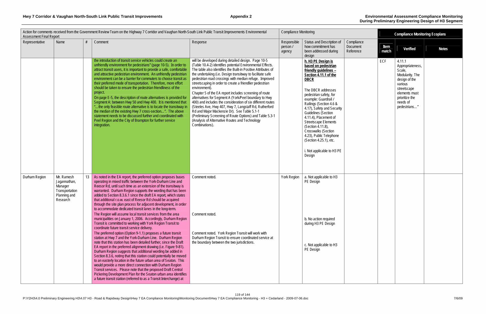
Hwy 7 Corridor & Vaughan North-South Link Public Transit Improvements Appendix 2 Environmental Assessment Compliance Monitoring During Preliminary Engineering Design of H3 Segment
119 of 144 P:\Y2H3\4.0 Preliminary Engineering H3\4.07 H3 - Road & Rapidway Design\Hwy 7 EA Compliance Monitoring\Monitoring Document\Hwy 7 EA Compliance Monitoring - H3 + Cedarland - 2009-07-06.doc 7/6/09
Action for comments received from the Government Review Team on the Highway 7 Corridor and Vaughan North-South Link Public Transit Improvements Environmental Assessment Final Report
Compliance Monitoring Compliance Monitoring Ecoplans
Representative Name # Comment Response Responsible person / agency
Status and Description of how commitment has been addressed during design
Compliance Document Reference
Item match
Verified Notes
the introduction of transit service vehicles could create an unfriendly environment for pedestrians” (page 10-5). In order to attract transit users, it is important to provide a safe, comfortable and attractive pedestrian environment. An unfriendly pedestrian environment can be a barrier for commuters to choose transit as their preferred mode of transportation. Therefore, more effort should be taken to ensure the pedestrian friendliness of the project. On page E-5, the description of route alternatives is provided for Segment A: between Hwy 50 and Hwy 400. It is mentioned that “…the only feasible route alternative is to locate the transitway in the median of the existing Hwy 7 cross-section…”. The above statement needs to be discussed further and coordinated with Peel Region and the City of Brampton for further service integration.
will be developed during detailed design. Page 10-5 (Table 10.4-2) identifies potential Environmental Effects. The table also identifies the Built-in Positive Attributes of the undertaking (i.e. Design transitway to facilitate safe pedestrian road crossings with median refuge. Improved streetscaping in order to create a friendlier pedestrian environment). Chapter 5 of the EA report includes screening of route alternatives for Segment A (York/Peel boundary to Hwy 400) and includes the consideration of six different routes (Steeles Ave, Hwy 407, Hwy 7, Langstaff Rd, Rutherford Rd and Major Mackenzie Dr). See Table 5.1-1 (Preliminary Screening of Route Options) and Table 5.3-1 (Analysis of Alternative Routes and Technology Combinations).
h. H3 PE Design is based on pedestrian friendly guidelines – Section 4.11.1 of the DBCR The DBCR addresses pedestrian safety, for example: Guardrail / Railings (Section 4.6 & 4.17), Safety and Security Guidelines (Section 4.11.4), Placement of Streetscape Elements (Section 4.11.8), Crosswalks (Section 4.23), Public Telephone (Section 4.25.1), etc. i. Not applicable to H3 PE Design
ECF 4.11.1 Appropriateness, Scale, Modularity. The design of the various streetscape elements must prioritize the needs of pedestrians…”
Durham Region Mr. Ramesh Jagannathan, Manager Transportation Planning and Research
13 As noted in the EA report, the preferred option proposes buses operating in mixed traffic between the York-Durham Line and Reesor Rd, until such time as an extension of the transitway is warranted. Durham Region supports the wording that has been added to Section 8.3.6.1 since the draft EA report, which states that additional r.o.w. east of Reesor Rd should be acquired through the site plan process for adjacent development, in order to accommodate dedicated transit lanes in the long-term. The Region will assume local transit services from the area municipalities on January 1, 2006. Accordingly, Durham Region Transit is committed to working with York Region Transit to coordinate future transit service delivery. The preferred option (Option 9-1.1) proposes a future transit station at Hwy 7 and the York-Durham Line. Durham Region note that this station has been detailed further, since the Draft EA report in the preferred alignment drawing (i.e. Figure 9-81). Durham Region suggests that additional wording be added in Section 8.3.6, noting that this station could potentially be moved to an easterly location in the future urban area of Seaton. This would provide a more direct connection with Durham Region Transit services. Please note that the proposed Draft Central Pickering Development Plan for the Seaton urban area identifies a future transit station (referred to as a Transit Interchange) at
Comment noted. Comment noted. Comment noted. York Region Transit will work with Durham Region Transit to ensure coordinated service at the boundary between the two jurisdictions.
York Region a. Not applicable to H3 PE Design b. No action required during H3 PE Design c. Not applicable to H3 PE Design

Hwy 7 Corridor & Vaughan North-South Link Public Transit Improvements Appendix 2 Environmental Assessment Compliance Monitoring During Preliminary Engineering Design of H3 Segment
120 of 144 P:\Y2H3\4.0 Preliminary Engineering H3\4.07 H3 - Road & Rapidway Design\Hwy 7 EA Compliance Monitoring\Monitoring Document\Hwy 7 EA Compliance Monitoring - H3 + Cedarland - 2009-07-06.doc 7/6/09
Action for comments received from the Government Review Team on the Highway 7 Corridor and Vaughan North-South Link Public Transit Improvements Environmental Assessment Final Report
Compliance Monitoring Compliance Monitoring Ecoplans
Representative Name # Comment Response Responsible person / agency
Status and Description of how commitment has been addressed during design
Compliance Document Reference
Item match
Verified Notes
Hwy 407 and Sideline 26. The choice of Hwy 7 for rapid transit services, over Hwy 407, is understandable given York Region’s focus on intra-regional urban transit services. The Hwy 407 Transitway, however, is more significant from an inter-regional point of view. As such, rapid transit service on Hwy 7 should be treated and designed to be complementary with future Hwy 407 Transitway services, rather than competitive.
Comment noted. As noted in this comment and described in the Region’s Transportation Master Plan and in various sections of the EA report, the undertaking is a key component of the York Region Rapid Transit Plan, which focuses on intra-regional urban rapid transit, with connections to inter-regional services (such as GO Rail and 407 Transitway) and other neighbouring rapid transit (TTC etc…).
d. No action required during H3 PE Design
Toronto and Region Conservation Authority
Ms. Beth Williston
14 TRCA recognizes that the Preferred Design requires a new crossing of the Rouge River (see figure 9-60). Staff met on site with York Region and Rouge Park representatives to discuss the implications of this crossing on November 18, 2005. Further to this meeting, staff completed its review of the document and advises that TRCA has no objection to the proposed crossing, as its impact to the placement and function of the transitway is now understood. Table 8.3-9 should be revised in order to clearly distinguish this alternative as preferable to the others, particularly as it will have the greatest negative impact on the natural environment. Any new crossing of a valley or stream corridor has a significant impact on the ecological function of the system. In accordance with TRCA's Valley and Stream Corridor Management Program as well as Rouge Park programs and policies, valley and stream crossings must be minimized in order to preserve the environmental integrity of the system. To this end, TRCA is advising that any future crossings of the Rouge River and its tributaries in this area are of significant concern. TRCA and Rouge Park will require that future Environmental Assessment or Planning Act applications in this area be developed such that no new crossings of the Rouge River, Apple Creek or Beaver Creek are approved. TRCA requests that York Region commit to restoring the surrounding valley land and floodplain as part of a compensation plan to address the impacts associated with this new crossing. This process would include the acquisition of the flood plain property west of Warden Avenue and south of Cedarland Drive for this purpose. A restoration plan should be prepared in consultation with TRCA staff to ensure that Terrestrial Natural Heritage objectives are met to maximize the ecological benefit to this area. Not withstanding the above, additional compensation may be required when this project moves to detailed design.
TRCA agreement in principle to the proposed Rouge River crossing is noted. A revised Table 8.3-9 is included in the attached supplemental information to TRCA. The table is revised to include more of the detailed information as presented in Table 8.3-5 and wording as summarized in the text of section 8.3.5.1 that better distinguishes the preferred alignment alternative. Comment noted for future Environmental Assessment or Planning Act applications in this area. The Region will work with TRCA to develop a compensation plan during detailed design that satisfies the agencies requirements. As noted in section 11.2.1, the requirement for TRCA permits are identified as part of post-EA approval activities.
York Region a. A draft Cedarland Alignment Modification Report is being finalised following receipt of MOE and TRCA comments – see Appendix 4 for monitoring. H3 PE Design provides for crossing of the Rouge River on Warden Avenue, requiring 11m of bridge widening. TRCA was consulted during development of the Cedarland Alignment Modification Report. To be resolved in the detail design phase / discussed with TRCA, as required. b. No action required during H3 PE Design c. No action required during H3 PE Design d. A draft Cedarland Alignment Modification Report is being finalised following receipt of MOE
Draft Cedarland Alignment Modification Report – Y2H3 6.03 (ID# 3018) Draft Cedarland Alignment Modification Report – Y2H3 6.03 (ID# 3018)
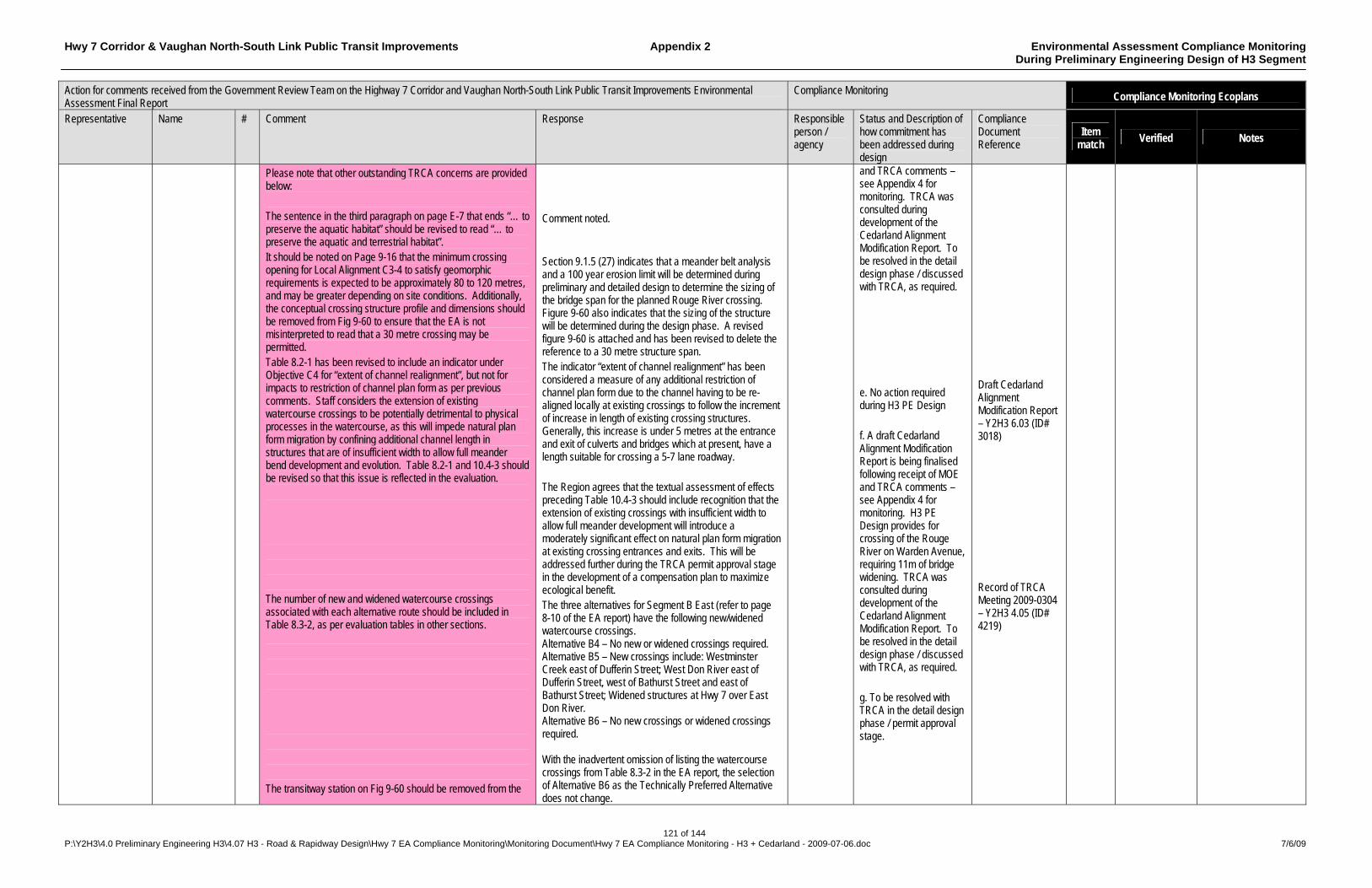
Hwy 7 Corridor & Vaughan North-South Link Public Transit Improvements Appendix 2 Environmental Assessment Compliance Monitoring During Preliminary Engineering Design of H3 Segment
121 of 144 P:\Y2H3\4.0 Preliminary Engineering H3\4.07 H3 - Road & Rapidway Design\Hwy 7 EA Compliance Monitoring\Monitoring Document\Hwy 7 EA Compliance Monitoring - H3 + Cedarland - 2009-07-06.doc 7/6/09
Action for comments received from the Government Review Team on the Highway 7 Corridor and Vaughan North-South Link Public Transit Improvements Environmental Assessment Final Report
Compliance Monitoring Compliance Monitoring Ecoplans
Representative Name # Comment Response Responsible person / agency
Status and Description of how commitment has been addressed during design
Compliance Document Reference
Item match
Verified Notes
Please note that other outstanding TRCA concerns are provided below: The sentence in the third paragraph on page E-7 that ends “… to preserve the aquatic habitat” should be revised to read “… to preserve the aquatic and terrestrial habitat”. It should be noted on Page 9-16 that the minimum crossing opening for Local Alignment C3-4 to satisfy geomorphic requirements is expected to be approximately 80 to 120 metres, and may be greater depending on site conditions. Additionally, the conceptual crossing structure profile and dimensions should be removed from Fig 9-60 to ensure that the EA is not misinterpreted to read that a 30 metre crossing may be permitted. Table 8.2-1 has been revised to include an indicator under Objective C4 for “extent of channel realignment”, but not for impacts to restriction of channel plan form as per previous comments. Staff considers the extension of existing watercourse crossings to be potentially detrimental to physical processes in the watercourse, as this will impede natural plan form migration by confining additional channel length in structures that are of insufficient width to allow full meander bend development and evolution. Table 8.2-1 and 10.4-3 should be revised so that this issue is reflected in the evaluation. The number of new and widened watercourse crossings associated with each alternative route should be included in Table 8.3-2, as per evaluation tables in other sections. The transitway station on Fig 9-60 should be removed from the
Comment noted. Section 9.1.5 (27) indicates that a meander belt analysis and a 100 year erosion limit will be determined during preliminary and detailed design to determine the sizing of the bridge span for the planned Rouge River crossing. Figure 9-60 also indicates that the sizing of the structure will be determined during the design phase. A revised figure 9-60 is attached and has been revised to delete the reference to a 30 metre structure span. The indicator “extent of channel realignment” has been considered a measure of any additional restriction of channel plan form due to the channel having to be re-aligned locally at existing crossings to follow the increment of increase in length of existing crossing structures. Generally, this increase is under 5 metres at the entrance and exit of culverts and bridges which at present, have a length suitable for crossing a 5-7 lane roadway. The Region agrees that the textual assessment of effects preceding Table 10.4-3 should include recognition that the extension of existing crossings with insufficient width to allow full meander development will introduce a moderately significant effect on natural plan form migration at existing crossing entrances and exits. This will be addressed further during the TRCA permit approval stage in the development of a compensation plan to maximize ecological benefit. The three alternatives for Segment B East (refer to page 8-10 of the EA report) have the following new/widened watercourse crossings. Alternative B4 – No new or widened crossings required. Alternative B5 – New crossings include: Westminster Creek east of Dufferin Street; West Don River east of Dufferin Street, west of Bathurst Street and east of Bathurst Street; Widened structures at Hwy 7 over East Don River. Alternative B6 – No new crossings or widened crossings required. With the inadvertent omission of listing the watercourse crossings from Table 8.3-2 in the EA report, the selection of Alternative B6 as the Technically Preferred Alternative does not change.
and TRCA comments – see Appendix 4 for monitoring. TRCA was consulted during development of the Cedarland Alignment Modification Report. To be resolved in the detail design phase / discussed with TRCA, as required. e. No action required during H3 PE Design f. A draft Cedarland Alignment Modification Report is being finalised following receipt of MOE and TRCA comments – see Appendix 4 for monitoring. H3 PE Design provides for crossing of the Rouge River on Warden Avenue, requiring 11m of bridge widening. TRCA was consulted during development of the Cedarland Alignment Modification Report. To be resolved in the detail design phase / discussed with TRCA, as required. g. To be resolved with TRCA in the detail design phase / permit approval stage.
Draft Cedarland Alignment Modification Report – Y2H3 6.03 (ID# 3018) Record of TRCA Meeting 2009-0304 – Y2H3 4.05 (ID# 4219)
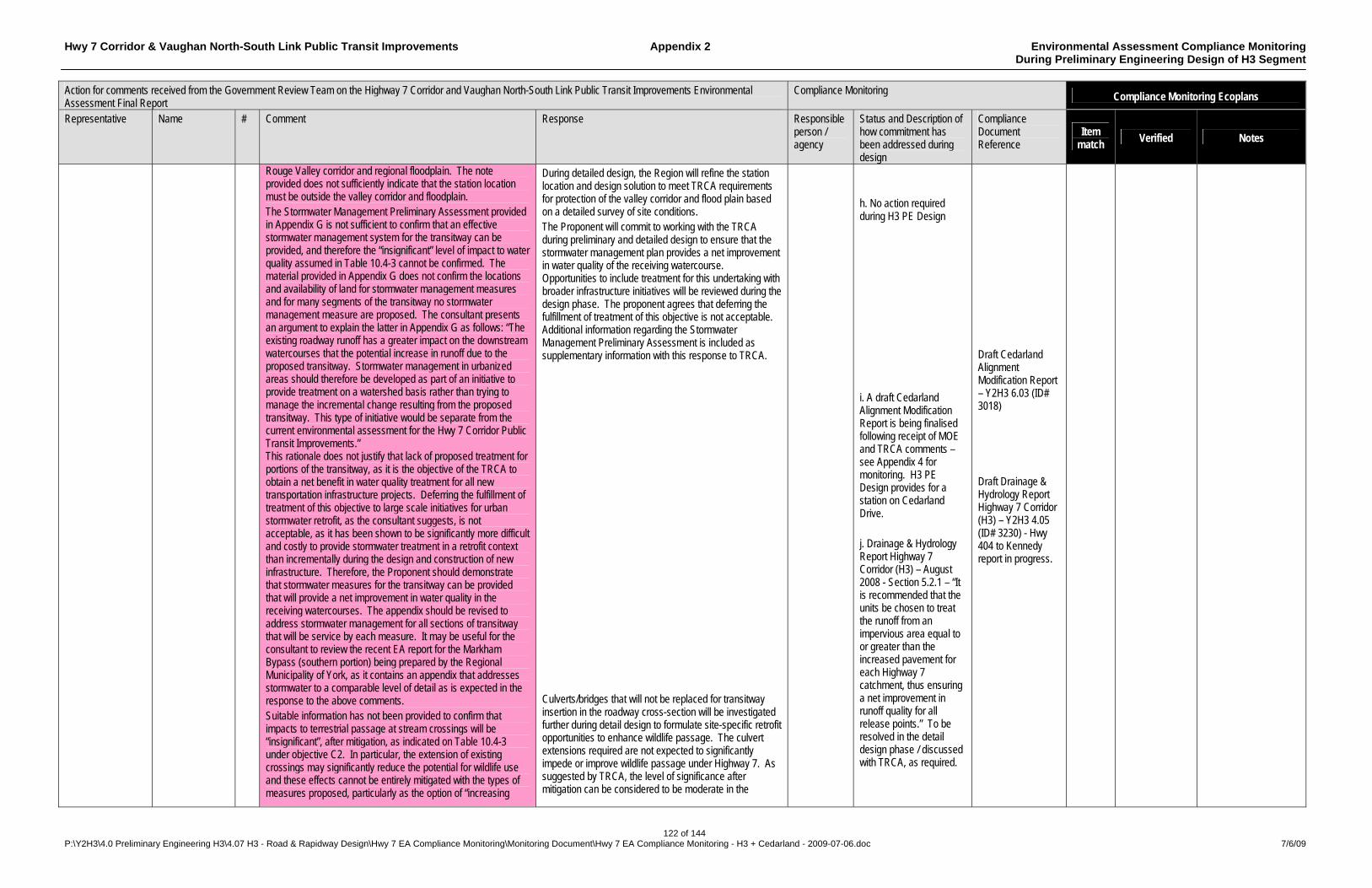
Hwy 7 Corridor & Vaughan North-South Link Public Transit Improvements Appendix 2 Environmental Assessment Compliance Monitoring During Preliminary Engineering Design of H3 Segment
122 of 144 P:\Y2H3\4.0 Preliminary Engineering H3\4.07 H3 - Road & Rapidway Design\Hwy 7 EA Compliance Monitoring\Monitoring Document\Hwy 7 EA Compliance Monitoring - H3 + Cedarland - 2009-07-06.doc 7/6/09
Action for comments received from the Government Review Team on the Highway 7 Corridor and Vaughan North-South Link Public Transit Improvements Environmental Assessment Final Report
Compliance Monitoring Compliance Monitoring Ecoplans
Representative Name # Comment Response Responsible person / agency
Status and Description of how commitment has been addressed during design
Compliance Document Reference
Item match
Verified Notes
Rouge Valley corridor and regional floodplain. The note provided does not sufficiently indicate that the station location must be outside the valley corridor and floodplain. The Stormwater Management Preliminary Assessment provided in Appendix G is not sufficient to confirm that an effective stormwater management system for the transitway can be provided, and therefore the “insignificant” level of impact to water quality assumed in Table 10.4-3 cannot be confirmed. The material provided in Appendix G does not confirm the locations and availability of land for stormwater management measures and for many segments of the transitway no stormwater management measure are proposed. The consultant presents an argument to explain the latter in Appendix G as follows: “The existing roadway runoff has a greater impact on the downstream watercourses that the potential increase in runoff due to the proposed transitway. Stormwater management in urbanized areas should therefore be developed as part of an initiative to provide treatment on a watershed basis rather than trying to manage the incremental change resulting from the proposed transitway. This type of initiative would be separate from the current environmental assessment for the Hwy 7 Corridor Public Transit Improvements.” This rationale does not justify that lack of proposed treatment for portions of the transitway, as it is the objective of the TRCA to obtain a net benefit in water quality treatment for all new transportation infrastructure projects. Deferring the fulfillment of treatment of this objective to large scale initiatives for urban stormwater retrofit, as the consultant suggests, is not acceptable, as it has been shown to be significantly more difficult and costly to provide stormwater treatment in a retrofit context than incrementally during the design and construction of new infrastructure. Therefore, the Proponent should demonstrate that stormwater measures for the transitway can be provided that will provide a net improvement in water quality in the receiving watercourses. The appendix should be revised to address stormwater management for all sections of transitway that will be service by each measure. It may be useful for the consultant to review the recent EA report for the Markham Bypass (southern portion) being prepared by the Regional Municipality of York, as it contains an appendix that addresses stormwater to a comparable level of detail as is expected in the response to the above comments. Suitable information has not been provided to confirm that impacts to terrestrial passage at stream crossings will be “insignificant”, after mitigation, as indicated on Table 10.4-3 under objective C2. In particular, the extension of existing crossings may significantly reduce the potential for wildlife use and these effects cannot be entirely mitigated with the types of measures proposed, particularly as the option of “increasing
During detailed design, the Region will refine the station location and design solution to meet TRCA requirements for protection of the valley corridor and flood plain based on a detailed survey of site conditions. The Proponent will commit to working with the TRCA during preliminary and detailed design to ensure that the stormwater management plan provides a net improvement in water quality of the receiving watercourse. Opportunities to include treatment for this undertaking with broader infrastructure initiatives will be reviewed during the design phase. The proponent agrees that deferring the fulfillment of treatment of this objective is not acceptable. Additional information regarding the Stormwater Management Preliminary Assessment is included as supplementary information with this response to TRCA. Culverts/bridges that will not be replaced for transitway insertion in the roadway cross-section will be investigated further during detail design to formulate site-specific retrofit opportunities to enhance wildlife passage. The culvert extensions required are not expected to significantly impede or improve wildlife passage under Highway 7. As suggested by TRCA, the level of significance after mitigation can be considered to be moderate in the
h. No action required during H3 PE Design i. A draft Cedarland Alignment Modification Report is being finalised following receipt of MOE and TRCA comments – see Appendix 4 for monitoring. H3 PE Design provides for a station on Cedarland Drive. j. Drainage & Hydrology Report Highway 7 Corridor (H3) – August 2008 - Section 5.2.1 – “It is recommended that the units be chosen to treat the runoff from an impervious area equal to or greater than the increased pavement for each Highway 7 catchment, thus ensuring a net improvement in runoff quality for all release points.” To be resolved in the detail design phase / discussed with TRCA, as required.
Draft Cedarland Alignment Modification Report – Y2H3 6.03 (ID# 3018) Draft Drainage & Hydrology Report Highway 7 Corridor (H3) – Y2H3 4.05 (ID# 3230) - Hwy 404 to Kennedy report in progress.
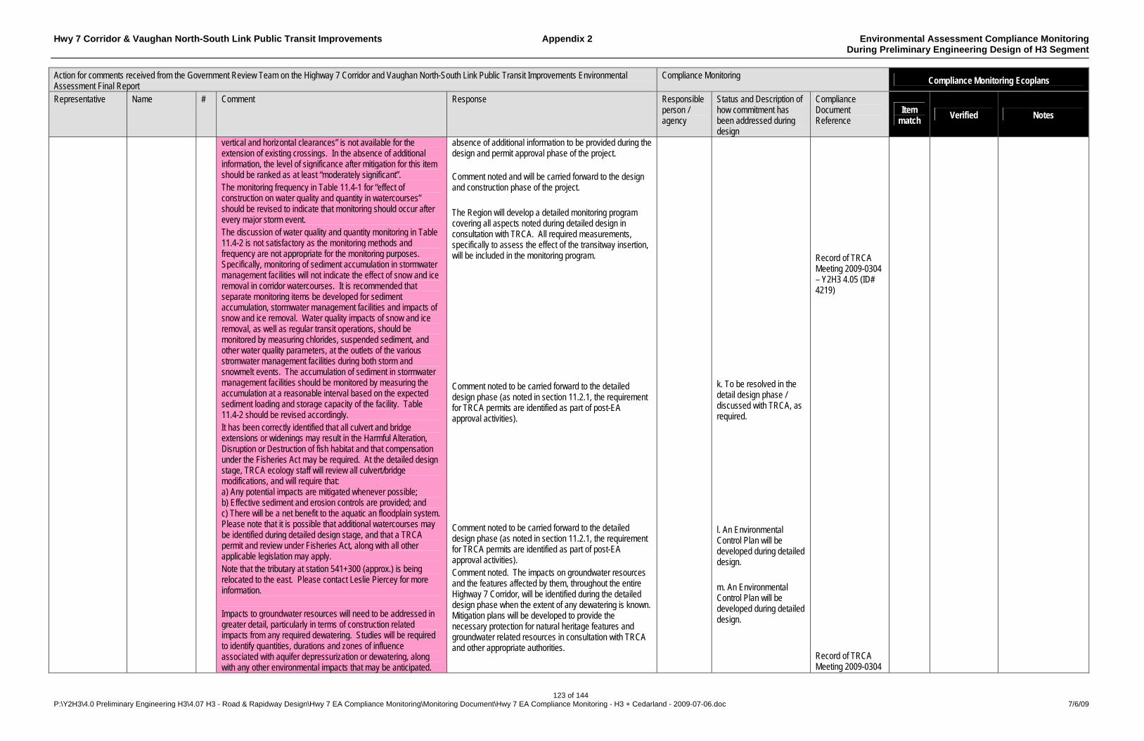
Hwy 7 Corridor & Vaughan North-South Link Public Transit Improvements Appendix 2 Environmental Assessment Compliance Monitoring During Preliminary Engineering Design of H3 Segment
123 of 144 P:\Y2H3\4.0 Preliminary Engineering H3\4.07 H3 - Road & Rapidway Design\Hwy 7 EA Compliance Monitoring\Monitoring Document\Hwy 7 EA Compliance Monitoring - H3 + Cedarland - 2009-07-06.doc 7/6/09
Action for comments received from the Government Review Team on the Highway 7 Corridor and Vaughan North-South Link Public Transit Improvements Environmental Assessment Final Report
Compliance Monitoring Compliance Monitoring Ecoplans
Representative Name # Comment Response Responsible person / agency
Status and Description of how commitment has been addressed during design
Compliance Document Reference
Item match
Verified Notes
vertical and horizontal clearances” is not available for the extension of existing crossings. In the absence of additional information, the level of significance after mitigation for this item should be ranked as at least “moderately significant”. The monitoring frequency in Table 11.4-1 for “effect of construction on water quality and quantity in watercourses” should be revised to indicate that monitoring should occur after every major storm event. The discussion of water quality and quantity monitoring in Table 11.4-2 is not satisfactory as the monitoring methods and frequency are not appropriate for the monitoring purposes. Specifically, monitoring of sediment accumulation in stormwater management facilities will not indicate the effect of snow and ice removal in corridor watercourses. It is recommended that separate monitoring items be developed for sediment accumulation, stormwater management facilities and impacts of snow and ice removal. Water quality impacts of snow and ice removal, as well as regular transit operations, should be monitored by measuring chlorides, suspended sediment, and other water quality parameters, at the outlets of the various stromwater management facilities during both storm and snowmelt events. The accumulation of sediment in stormwater management facilities should be monitored by measuring the accumulation at a reasonable interval based on the expected sediment loading and storage capacity of the facility. Table 11.4-2 should be revised accordingly. It has been correctly identified that all culvert and bridge extensions or widenings may result in the Harmful Alteration, Disruption or Destruction of fish habitat and that compensation under the Fisheries Act may be required. At the detailed design stage, TRCA ecology staff will review all culvert/bridge modifications, and will require that: a) Any potential impacts are mitigated whenever possible; b) Effective sediment and erosion controls are provided; and c) There will be a net benefit to the aquatic an floodplain system. Please note that it is possible that additional watercourses may be identified during detailed design stage, and that a TRCA permit and review under Fisheries Act, along with all other applicable legislation may apply. Note that the tributary at station 541+300 (approx.) is being relocated to the east. Please contact Leslie Piercey for more information. Impacts to groundwater resources will need to be addressed in greater detail, particularly in terms of construction related impacts from any required dewatering. Studies will be required to identify quantities, durations and zones of influence associated with aquifer depressurization or dewatering, along with any other environmental impacts that may be anticipated.
absence of additional information to be provided during the design and permit approval phase of the project. Comment noted and will be carried forward to the design and construction phase of the project. The Region will develop a detailed monitoring program covering all aspects noted during detailed design in consultation with TRCA. All required measurements, specifically to assess the effect of the transitway insertion, will be included in the monitoring program. Comment noted to be carried forward to the detailed design phase (as noted in section 11.2.1, the requirement for TRCA permits are identified as part of post-EA approval activities). Comment noted to be carried forward to the detailed design phase (as noted in section 11.2.1, the requirement for TRCA permits are identified as part of post-EA approval activities). Comment noted. The impacts on groundwater resources and the features affected by them, throughout the entire Highway 7 Corridor, will be identified during the detailed design phase when the extent of any dewatering is known. Mitigation plans will be developed to provide the necessary protection for natural heritage features and groundwater related resources in consultation with TRCA and other appropriate authorities.
k. To be resolved in the detail design phase / discussed with TRCA, as required. l. An Environmental Control Plan will be developed during detailed design. m. An Environmental Control Plan will be developed during detailed design.
Record of TRCA Meeting 2009-0304 – Y2H3 4.05 (ID# 4219) Record of TRCA Meeting 2009-0304
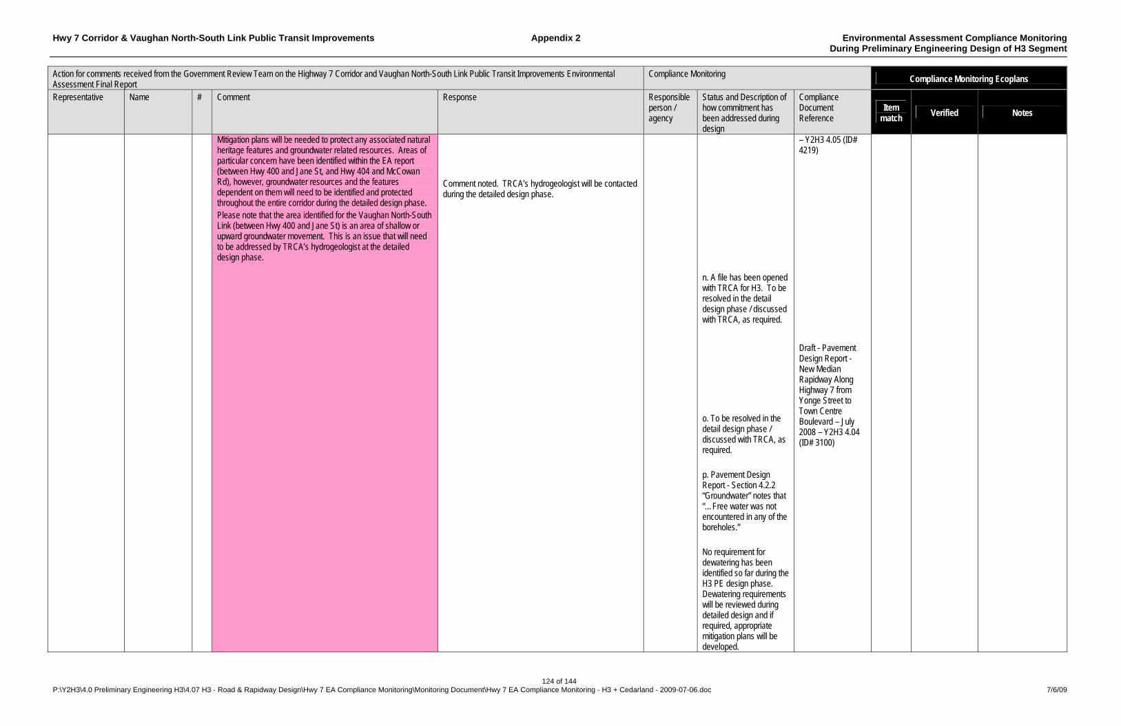
Hwy 7 Corridor & Vaughan North-South Link Public Transit Improvements Appendix 2 Environmental Assessment Compliance Monitoring During Preliminary Engineering Design of H3 Segment
124 of 144 P:\Y2H3\4.0 Preliminary Engineering H3\4.07 H3 - Road & Rapidway Design\Hwy 7 EA Compliance Monitoring\Monitoring Document\Hwy 7 EA Compliance Monitoring - H3 + Cedarland - 2009-07-06.doc 7/6/09
Action for comments received from the Government Review Team on the Highway 7 Corridor and Vaughan North-South Link Public Transit Improvements Environmental Assessment Final Report
Compliance Monitoring Compliance Monitoring Ecoplans
Representative Name # Comment Response Responsible person / agency
Status and Description of how commitment has been addressed during design
Compliance Document Reference
Item match
Verified Notes
Mitigation plans will be needed to protect any associated natural heritage features and groundwater related resources. Areas of particular concern have been identified within the EA report (between Hwy 400 and Jane St, and Hwy 404 and McCowan Rd), however, groundwater resources and the features dependent on them will need to be identified and protected throughout the entire corridor during the detailed design phase. Please note that the area identified for the Vaughan North-South Link (between Hwy 400 and Jane St) is an area of shallow or upward groundwater movement. This is an issue that will need to be addressed by TRCA’s hydrogeologist at the detailed design phase.
Comment noted. TRCA’s hydrogeologist will be contacted during the detailed design phase.
n. A file has been opened with TRCA for H3. To be resolved in the detail design phase / discussed with TRCA, as required. o. To be resolved in the detail design phase / discussed with TRCA, as required. p. Pavement Design Report - Section 4.2.2 “Groundwater” notes that “…Free water was not encountered in any of the boreholes.” No requirement for dewatering has been identified so far during the H3 PE design phase. Dewatering requirements will be reviewed during detailed design and if required, appropriate mitigation plans will be developed.
– Y2H3 4.05 (ID# 4219) Draft - Pavement Design Report - New Median Rapidway Along Highway 7 from Yonge Street to Town Centre Boulevard – July 2008 – Y2H3 4.04 (ID# 3100)
Hwy 7 Corridor & Vaughan North-South Link Public Transit Improvements Appendix 2 Environmental Assessment Compliance Monitoring During Preliminary Engineering Design of H3 Segment
125 of 144 P:\Y2H3\4.0 Preliminary Engineering H3\4.07 H3 - Road & Rapidway Design\Hwy 7 EA Compliance Monitoring\Monitoring Document\Hwy 7 EA Compliance Monitoring - H3 + Cedarland - 2009-07-06.doc 7/6/09
Action for comments received from the Government Review Team on the Highway 7 Corridor and Vaughan North-South Link Public Transit Improvements Environmental Assessment Final Report
Compliance Monitoring Compliance Monitoring Ecoplans
Representative Name # Comment Response Responsible person / agency
Status and Description of how commitment has been addressed during design
Compliance Document Reference
Item match
Verified Notes
q. Not applicable to H3 PE Design
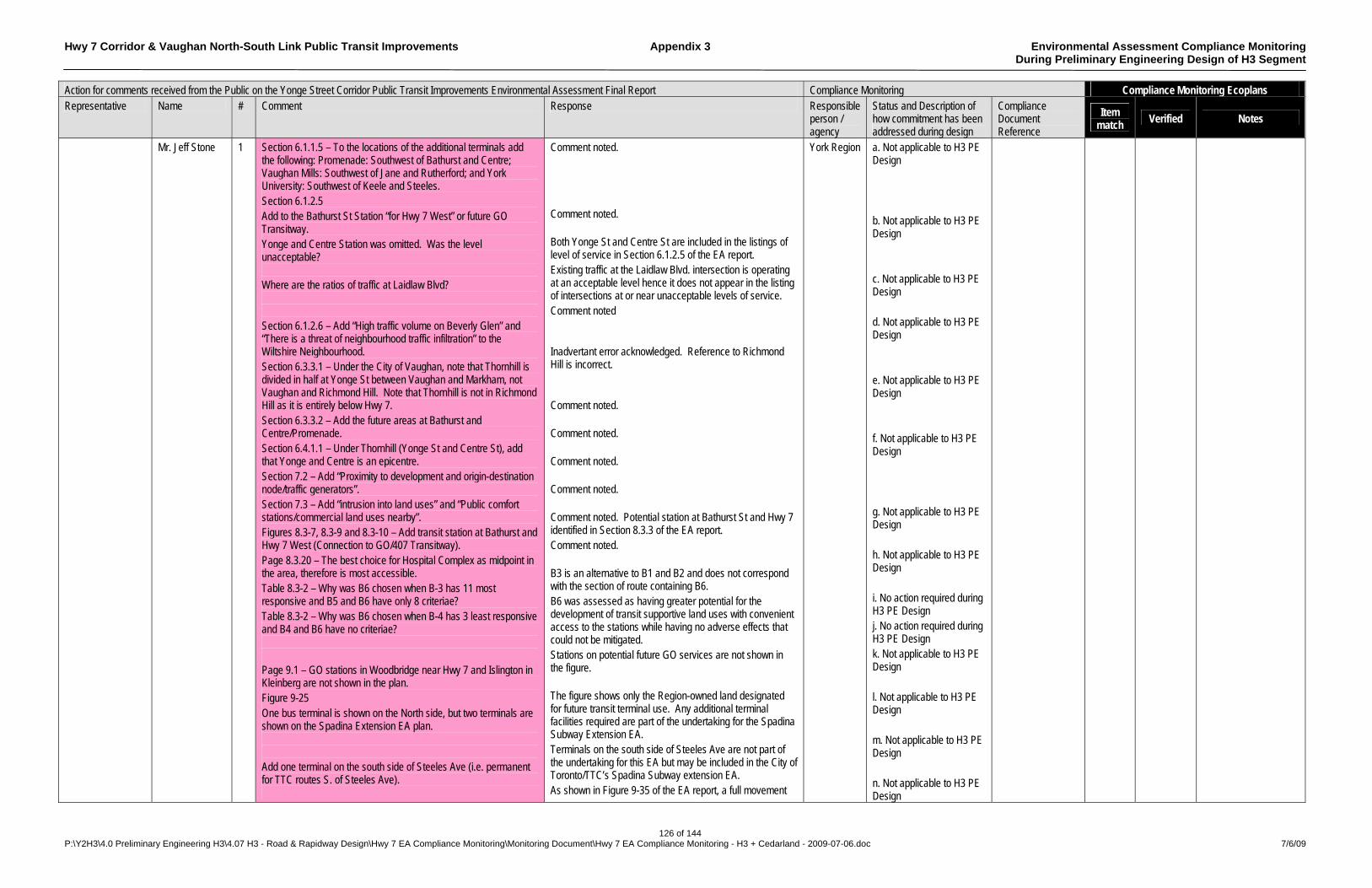
Hwy 7 Corridor & Vaughan North-South Link Public Transit Improvements Appendix 3 Environmental Assessment Compliance Monitoring During Preliminary Engineering Design of H3 Segment
126 of 144 P:\Y2H3\4.0 Preliminary Engineering H3\4.07 H3 - Road & Rapidway Design\Hwy 7 EA Compliance Monitoring\Monitoring Document\Hwy 7 EA Compliance Monitoring - H3 + Cedarland - 2009-07-06.doc 7/6/09
Action for comments received from the Public on the Yonge Street Corridor Public Transit Improvements Environmental Assessment Final Report Compliance Monitoring Compliance Monitoring Ecoplans Representative Name # Comment Response Responsible
person / agency
Status and Description of how commitment has been addressed during design
Compliance Document Reference
Item match Verified Notes
Mr. Jeff Stone 1 Section 6.1.1.5 – To the locations of the additional terminals add the following: Promenade: Southwest of Bathurst and Centre; Vaughan Mills: Southwest of Jane and Rutherford; and York University: Southwest of Keele and Steeles. Section 6.1.2.5 Add to the Bathurst St Station “for Hwy 7 West” or future GO Transitway. Yonge and Centre Station was omitted. Was the level unacceptable? Where are the ratios of traffic at Laidlaw Blvd? Section 6.1.2.6 – Add “High traffic volume on Beverly Glen” and “There is a threat of neighbourhood traffic infiltration” to the Wiltshire Neighbourhood. Section 6.3.3.1 – Under the City of Vaughan, note that Thornhill is divided in half at Yonge St between Vaughan and Markham, not Vaughan and Richmond Hill. Note that Thornhill is not in Richmond Hill as it is entirely below Hwy 7. Section 6.3.3.2 – Add the future areas at Bathurst and Centre/Promenade. Section 6.4.1.1 – Under Thornhill (Yonge St and Centre St), add that Yonge and Centre is an epicentre. Section 7.2 – Add “Proximity to development and origin-destination node/traffic generators”. Section 7.3 – Add “intrusion into land uses” and “Public comfort stations/commercial land uses nearby”. Figures 8.3-7, 8.3-9 and 8.3-10 – Add transit station at Bathurst and Hwy 7 West (Connection to GO/407 Transitway). Page 8.3.20 – The best choice for Hospital Complex as midpoint in the area, therefore is most accessible. Table 8.3-2 – Why was B6 chosen when B-3 has 11 most responsive and B5 and B6 have only 8 criteriae? Table 8.3-2 – Why was B6 chosen when B-4 has 3 least responsive and B4 and B6 have no criteriae? Page 9.1 – GO stations in Woodbridge near Hwy 7 and Islington in Kleinberg are not shown in the plan. Figure 9-25 One bus terminal is shown on the North side, but two terminals are shown on the Spadina Extension EA plan. Add one terminal on the south side of Steeles Ave (i.e. permanent for TTC routes S. of Steeles Ave).
Comment noted. Comment noted. Both Yonge St and Centre St are included in the listings of level of service in Section 6.1.2.5 of the EA report. Existing traffic at the Laidlaw Blvd. intersection is operating at an acceptable level hence it does not appear in the listing of intersections at or near unacceptable levels of service. Comment noted Inadvertant error acknowledged. Reference to Richmond Hill is incorrect. Comment noted. Comment noted. Comment noted. Comment noted. Comment noted. Potential station at Bathurst St and Hwy 7 identified in Section 8.3.3 of the EA report. Comment noted. B3 is an alternative to B1 and B2 and does not correspond with the section of route containing B6. B6 was assessed as having greater potential for the development of transit supportive land uses with convenient access to the stations while having no adverse effects that could not be mitigated. Stations on potential future GO services are not shown in the figure. The figure shows only the Region-owned land designated for future transit terminal use. Any additional terminal facilities required are part of the undertaking for the Spadina Subway Extension EA. Terminals on the south side of Steeles Ave are not part of the undertaking for this EA but may be included in the City of Toronto/TTC’s Spadina Subway extension EA. As shown in Figure 9-35 of the EA report, a full movement
York Region a. Not applicable to H3 PE Design b. Not applicable to H3 PE Design c. Not applicable to H3 PE Design d. Not applicable to H3 PE Design e. Not applicable to H3 PE Design f. Not applicable to H3 PE Design g. Not applicable to H3 PE Design h. Not applicable to H3 PE Design i. No action required during H3 PE Design j. No action required during H3 PE Design k. Not applicable to H3 PE Design l. Not applicable to H3 PE Design m. Not applicable to H3 PE Design n. Not applicable to H3 PE Design

Hwy 7 Corridor & Vaughan North-South Link Public Transit Improvements Appendix 3 Environmental Assessment Compliance Monitoring During Preliminary Engineering Design of H3 Segment
127 of 144 P:\Y2H3\4.0 Preliminary Engineering H3\4.07 H3 - Road & Rapidway Design\Hwy 7 EA Compliance Monitoring\Monitoring Document\Hwy 7 EA Compliance Monitoring - H3 + Cedarland - 2009-07-06.doc 7/6/09
Action for comments received from the Public on the Yonge Street Corridor Public Transit Improvements Environmental Assessment Final Report Compliance Monitoring Compliance Monitoring Ecoplans Representative Name # Comment Response Responsible
person / agency
Status and Description of how commitment has been addressed during design
Compliance Document Reference
Item match Verified Notes
Figure 9-35 – Add a second gap on Centre St to adequately serve retailers or some stores will die. Figure 9-36 The station site west of Promenade loop is on a slope and could pose stopping problems. The right turn lane should be extended south of Centre St to the condo building entrance for flow. Add a one to two lane northbound road versus three lanes shown in both directions on future plans. Note the northbound station north of Atkinson poses a problem for the retail strip plaza vehicle access. Note the southbound station south of Atkinson poses a problem for school and community centre access. Section 12 – A1 Station Site: The advantages are it is a better choice as it is under Steeles completely; lesser capital cost as no expropriation needed nor use of vacant land; better service to York University and has least effect on future development; and central location as perpendicular site allows access to all terminals. The disadvantage is that this location poses higher noise and vibration problems. Page 12-4 – Add “Possible 2nd bus terminal” on the north side. Note that non-TTC routes can be accommodated by one terminal until Spadina is extended north. In general, the EA omits reference to other potential east-west or north-south arterial corridors for rapid transit in future in south York Region.
intersection (signalized) has been shown conceptually providing access to the lands north of Centre St between Vaughan Blvd and New Westminster Dr. A station at the location shown will meet design standards. The extent of turning lanes will be determined after further analysis of needs during the detailed design phase. Bathurst St will retain the existing two lanes in each direction, with the additional lanes being dedicated to rapid transit. Access to the plaza on the east side of Bathurst St will be possible by making either a U-turn SB at the Atkinson Ave intersection followed by a right-turn into the plaza, or a left turn into Atkinson Ave and a second left-turn into the southern entrance to the plaza. Access to the community centre and school will be possible through the signalized intersection at New Westminster Dr. Comment noted. Overall terminal requirements at the Steeles Ave subway station are being defined by the Spadina Subway Extension EA. The station site will be addressed as part of the Spadina EA. The modeling of future rapid transit ridership has assumed enhanced transit service on parallel arterial routes in both the east-west and north-south directions.
o. Not applicable to H3 PE Design p. Not applicable to H3 PE Design q. Not applicable to H3 PE Design r. Not applicable to H3 PE Design s. Not applicable to H3 PE Design t. Not applicable to H3 PE Design u. Not applicable to H3 PE Design v. Not applicable to H3 PE Design w. Not applicable to H3 PE Design x. Not applicable to H3 PE Design
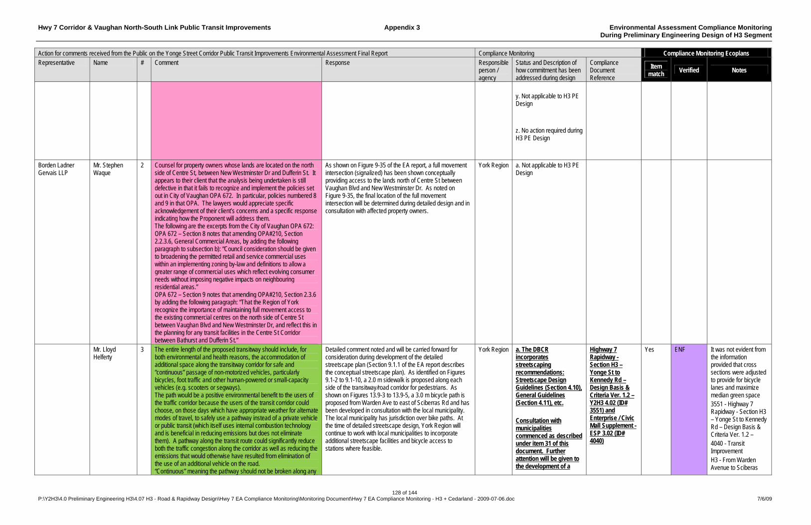
Hwy 7 Corridor & Vaughan North-South Link Public Transit Improvements Appendix 3 Environmental Assessment Compliance Monitoring During Preliminary Engineering Design of H3 Segment
128 of 144 P:\Y2H3\4.0 Preliminary Engineering H3\4.07 H3 - Road & Rapidway Design\Hwy 7 EA Compliance Monitoring\Monitoring Document\Hwy 7 EA Compliance Monitoring - H3 + Cedarland - 2009-07-06.doc 7/6/09
Action for comments received from the Public on the Yonge Street Corridor Public Transit Improvements Environmental Assessment Final Report Compliance Monitoring Compliance Monitoring Ecoplans Representative Name # Comment Response Responsible
person / agency
Status and Description of how commitment has been addressed during design
Compliance Document Reference
Item match Verified Notes
y. Not applicable to H3 PE Design z. No action required during H3 PE Design
Borden Ladner Gervais LLP
Mr. Stephen Waque
2 Counsel for property owners whose lands are located on the north side of Centre St, between New Westminster Dr and Dufferin St. It appears to their client that the analysis being undertaken is still defective in that it fails to recognize and implement the policies set out in City of Vaughan OPA 672. In particular, policies numbered 8 and 9 in that OPA. The lawyers would appreciate specific acknowledgement of their client’s concerns and a specific response indicating how the Proponent will address them. The following are the excerpts from the City of Vaughan OPA 672: OPA 672 – Section 8 notes that amending OPA#210, Section 2.2.3.6, General Commercial Areas, by adding the following paragraph to subsection b): “Council consideration should be given to broadening the permitted retail and service commercial uses within an implementing zoning by-law and definitions to allow a greater range of commercial uses which reflect evolving consumer needs without imposing negative impacts on neighbouring residential areas.” OPA 672 – Section 9 notes that amending OPA#210, Section 2.3.6 by adding the following paragraph: “That the Region of York recognize the importance of maintaining full movement access to the existing commercial centres on the north side of Centre St between Vaughan Blvd and New Westminster Dr, and reflect this in the planning for any transit facilities in the Centre St Corridor between Bathurst and Dufferin St.”
As shown on Figure 9-35 of the EA report, a full movement intersection (signalized) has been shown conceptually providing access to the lands north of Centre St between Vaughan Blvd and New Westminster Dr. As noted on Figure 9-35, the final location of the full movement intersection will be determined during detailed design and in consultation with affected property owners.
York Region a. Not applicable to H3 PE Design
Mr. Lloyd Helferty
3 The entire length of the proposed transitway should include, for both environmental and health reasons, the accommodation of additional space along the transitway corridor for safe and “continuous” passage of non-motorized vehicles, particularly bicycles, foot traffic and other human-powered or small-capacity vehicles (e.g. scooters or segways). The path would be a positive environmental benefit to the users of the traffic corridor because the users of the transit corridor could choose, on those days which have appropriate weather for alternate modes of travel, to safely use a pathway instead of a private vehicle or public transit (which itself uses internal combustion technology and is beneficial in reducing emissions but does not eliminate them). A pathway along the transit route could significantly reduce both the traffic congestion along the corridor as well as reducing the emissions that would otherwise have resulted from elimination of the use of an additional vehicle on the road. “Continuous” meaning the pathway should not be broken along any
Detailed comment noted and will be carried forward for consideration during development of the detailed streetscape plan (Section 9.1.1 of the EA report describes the conceptual streetscape plan). As identified on Figures 9.1-2 to 9.1-10, a 2.0 m sidewalk is proposed along each side of the transitway/road corridor for pedestrians. As shown on Figures 13.9-3 to 13.9-5, a 3.0 m bicycle path is proposed from Warden Ave to east of Sciberras Rd and has been developed in consultation with the local municipality. The local municipality has jurisdiction over bike paths. At the time of detailed streetscape design, York Region will continue to work with local municipalities to incorporate additional streetscape facilities and bicycle access to stations where feasible.
York Region a. The DBCR incorporates streetscaping recommendations: Streetscape Design Guidelines (Section 4.10), General Guidelines (Section 4.11), etc. Consultation with municipalities commenced as described under item 31 of this document. Further attention will be given to the development of a
Highway 7 Rapidway - Section H3 – Yonge St to Kennedy Rd – Design Basis & Criteria Ver. 1.2 – Y2H3 4.02 (ID# 3551) and Enterprise / Civic Mall Supplement - ESP 3.02 (ID# 4040)
Yes ENF It was not evident from the information provided that cross sections were adjusted to provide for bicycle lanes and maximize median green space 3551 - Highway 7 Rapidway - Section H3 – Yonge St to Kennedy Rd – Design Basis & Criteria Ver. 1.2 – 4040 - Transit Improvement H3 - From Warden Avenue to Sciberas
Hwy 7 Corridor & Vaughan North-South Link Public Transit Improvements Appendix 3 Environmental Assessment Compliance Monitoring During Preliminary Engineering Design of H3 Segment
129 of 144 P:\Y2H3\4.0 Preliminary Engineering H3\4.07 H3 - Road & Rapidway Design\Hwy 7 EA Compliance Monitoring\Monitoring Document\Hwy 7 EA Compliance Monitoring - H3 + Cedarland - 2009-07-06.doc 7/6/09
Action for comments received from the Public on the Yonge Street Corridor Public Transit Improvements Environmental Assessment Final Report Compliance Monitoring Compliance Monitoring Ecoplans Representative Name # Comment Response Responsible
person / agency
Status and Description of how commitment has been addressed during design
Compliance Document Reference
Item match Verified Notes
section because of incompleteness or obstruction (such as highway bridges), and should allow the passage of small/light vehicles without the users of such a path having to resort to simultaneous use of the same roadway as heavy vehicles.
streetscape plan in detailed design. Cross sections have been adjusted where possible to provide for bicycle lanes and maximize median green space.
Road Design Basis & Criteria Report (July 2009)
Mr. James Puddy
4 Mr. Puddy mailed letters concerning the meetings at Markville on September 19, 2003 and September 17, 2004 and had no replies. He went to the Markham Town Centre to review the EA report and noticed that there were eighty replies from the total of twelve meetings and did not see his letter of September 19, 2003, although his letter of September 17, 2004 was recorded. The following are his comments on the EA report: The transit lane should be in the curb lanes with the transit stops at the far side of the traffic control intersections. The transit lanes should run straight along the corridor with a subway or overpass at the GO crossing and not detoured up and down to the GO station where the trains operate approximately two hours each direction on working days. The raised transit lanes will separate the corridor into a north and south side of the community requiring at each traffic control intersection numerous traffic light functions such as through, right, left and U-turns. Comments b through d will increase gridlock, pollution, safety and will affect the community environment (surroundings). Comments from PCC#4, September 17, 2004 Mr. Puddy spoke to a representative of Lynton Erskine at the Markville Mall presentation on September 17, 2004. He does not consider the present plan will enhance the quality of life in the Hwy 7 Corridor. The transit lanes should be in the curb lane of Hwy 7 corridor with stops at the far side of intersections.
It appears that the Rapid Transit Program Office inadvertently omitted to acknowledge receipt of Mr. Puddy’s letters and respond to the comments contained in them. However, the comments were taken into consideration in evaluating alternatives and developing the preferred design for the undertaking. The responses below indicate how his comments were addressed in the EA report. Curb side transit lanes were considered in the EA report (refer to Section 5.4.1, Alternative Locations within a Road r.o.w.). Table 5.4-1 provides an evaluation of the alternative locations for the transit lanes, with a median transitway identified as the preferred location. The typical station layout includes far side stops at intersections with traffic and pedestrian control signals (refer to Figure 7.3-1). Alternative routes and alignments were considered and evaluated in the EA (refer to Section 5.3.1, Analysis and Evaluation of Alternative Technology/Route Combinations and Section 8.3, Development of Segment Alignment Alternatives). In addition to inter-connectivity with GO Rail services, the routing selected serves the planned mixed-use Markham Centre where significant transit-supportive development is planned. As noted in Section 9.1.1 of the EA, a streetscape concept has been developed in consultation with local municipalities to be a catalyst for transit-oriented development and attract transit ridership by creating a pedestrian friendly environment. The effect on traffic operations was considered in the evaluation of options to locate a transitway in a roadway (refer to Table 5.4-1) and the analysis of traffic conditions during operation of the transit service (refer to Chapter 10). In addition, traffic operations will be monitored during rapid transit operations as noted in Table 11.4-2. Environmental criteria for assessing the effects of the undertaking on congestion, pollution and safety are included in Section 10.4 - Analysis of Environmental Effects and Mitigation, of the EA report. Protecting and enhancing the social environment in the corridor was a key objective in the development of the undertaking (refer to Chapter 1 and Chapter 10, Table 10.4-2).
York Region a. No action required during H3 PE Design b. No action required during H3 PE Design c. No action required during H3 PE Design d. No action required during H3 PE Design e. No action required during H3 PE Design
Hwy 7 Corridor & Vaughan North-South Link Public Transit Improvements Appendix 3 Environmental Assessment Compliance Monitoring During Preliminary Engineering Design of H3 Segment
130 of 144 P:\Y2H3\4.0 Preliminary Engineering H3\4.07 H3 - Road & Rapidway Design\Hwy 7 EA Compliance Monitoring\Monitoring Document\Hwy 7 EA Compliance Monitoring - H3 + Cedarland - 2009-07-06.doc 7/6/09
Action for comments received from the Public on the Yonge Street Corridor Public Transit Improvements Environmental Assessment Final Report Compliance Monitoring Compliance Monitoring Ecoplans Representative Name # Comment Response Responsible
person / agency
Status and Description of how commitment has been addressed during design
Compliance Document Reference
Item match Verified Notes
The level crossing on Hwy 7 in Unionville should have an underpass allowing safe passage for GO trains and Hwy 7 traffic which was done at Finch Ave, west of Leslie St. The transit line in the middle of Hwy 7 corridor with its left and U-turns at intersections are not safe and convenient for pedestrians or vehicles contributing to gridlock and pollution. The transit line should not be detoured off the Hwy 7 corridor to the GO station for four trains each way on working days. The primary purpose of what used to be a provincial highway was for the movement of goods, people and services and should be the main function of this arterial road serving a commercial area. Comments from PCC#3, September 19, 2003 The preferred plan for enhancing the quality of life in the Hwy 7 corridor is similar to the Spadina Ave transit in Toronto and Mr. Puddy does not consider that the Toronto system meets any of our criteria for the proposed plan. Mr. Puddy suggests that the preferred plan for all purposes would be better located in either the hydro or 407 corridors. The rapid transit line in the centre of the Hwy 7 corridor would not contribute to the safety and convenience of pedestrians or other users. The detouring of the transit line off the corridor to connect with the GO station for only 10 trains on working days. The transit line should be built in the curb lanes and an underpass built at the Hwy 7 corridor and the GO level crossing which would allow passengers to transfer to the GO trains and provide a safe Hwy 7 corridor by eliminating a level crossing.
Curb side transit lanes were considered in the EA report (refer to Section 5.4.1, Alternative Locations within a Road r.o.w.). Table 5.4-1 provides an evaluation of the alternative locations for the transit lanes, with a median transitway identified as the preferred location. The typical station layout includes far side stops at intersections with traffic and pedestrian control signals (refer to Figure 7.3-1). Comment noted. Refer to Figure 9-63 of the EA report which shows a proposed underpass for the transitway crossing of the GO Stouffville line. Refer to responses c and d above. The purpose of the undertaking is presented in Section 1.2.2 of the EA report. The existing Social Environment is described in Section 6.3 and includes a wide range of adjacent land uses. Comment noted. Analysis and Evaluation of Alternatives to the Undertaking is provided in Chapter 3 of the EA report. Alternative alignments (including Hwy 407 and sections of hydro corridors) were considered in the EA (refer to Section 5.1, Rapid Transit Corridors). Alternative alignments (including Hwy 407 and sections of hydro corridors) were considered in the EA (refer to Section 5.1, Rapid Transit Corridors). Alternative alignments (including Hwy 407 and sections of hydro corridors) were considered in the EA (refer to Section 5.1, Rapid Transit Corridors).
f. No action required during H3 PE Design g. No action required during H3 PE Design h. No action required during H3 PE Design i. No action required during H3 PE Design j. No action required during H3 PE Design k. No action required during H3 PE Design l. No action required during H3 PE Design m. No action required during H3 PE Design n. No action required during H3 PE Design
Ms. Gloria Boxen
5 Ms. Boxen welcomes the Region’s decision to improve transit but is concerned about the Region’s inability to address land use planning where it works against good transit and community development and when it doesn’t dare to hope that people will get out of their cars and walk. The evaluation and comments provided are based on the following
Approval of site plan development is a local municipal jurisdiction and subject to the Ontario Planning Act, as well as conformance with land use as provided in the York Region Official Plan. The Region is also undertaking a Centres and Corridors Study to facilitate development of both the Regional Centres and Corridors with more intensive development supporting transit ridership (the Region’s planning initiatives are briefly described in Section 12.1.1 of the EA report).
York Region a. No action required during H3 PE Design
Yes
Hwy 7 Corridor & Vaughan North-South Link Public Transit Improvements Appendix 3 Environmental Assessment Compliance Monitoring During Preliminary Engineering Design of H3 Segment
131 of 144 P:\Y2H3\4.0 Preliminary Engineering H3\4.07 H3 - Road & Rapidway Design\Hwy 7 EA Compliance Monitoring\Monitoring Document\Hwy 7 EA Compliance Monitoring - H3 + Cedarland - 2009-07-06.doc 7/6/09
Action for comments received from the Public on the Yonge Street Corridor Public Transit Improvements Environmental Assessment Final Report Compliance Monitoring Compliance Monitoring Ecoplans Representative Name # Comment Response Responsible
person / agency
Status and Description of how commitment has been addressed during design
Compliance Document Reference
Item match Verified Notes
principles: 1) Efficient use of resources, existing infrastructure, land, energy, and most direct route to service the most people and destinations, with least environmental impacts; 2) Promotes health, reduces air, water and soil pollution by reducing the use and need for private vehicles, and promotes walking and cycling; 3) Other environmental concerns – Decreases the need for paved and other impervious surfaces and reduces flood potential. Increases vegetation to reduce runoff, provide shade, filter pollutants, and absorb CO2. reduces greenhouse gas emissions and moderated the effects of climate change; 4) Promotes community health – stops and terminals are located near centres of activity. Accessible to all residents in geographical sense and to those with physical handicaps. Inclusive of residents regardless of age and economical status; and 5) Convenience. Current Events Ms. Boxen presumes that the study does not include the impacts of the construction of the additional lanes on Hwy 407 in the central portion that are exempt from environmental assessment. These impacts should be added to those calculated for any added lanes to Hwy 7. Does the study take into account today’s world? The world has changed since the study commenced. Gas prices have gone from cheap to a point where people are actively looking for other means of transportation such as walking and cycling, as well as transit. Price volatility has mirrored the weather’s volatility. Scientists have predicted the weather extremes and severity would increase with increased greenhouse gases and climate change. Decreasing the permeable surfaces through increased road pavement and loss of greenspace helps to increase the risk of flooding. If we are to implement infrastructure changes to accommodate rapid transit, they must be taken from existing paved surfaces or be in the form of rail. In August there was local flooding in basements in Thornhill and North York. Finch Avenue near Jane Street was washed out at Black Creek. Look again at the calculated impacts of increased river crossings and determine if they are realistic in view of what happened in August. Road Capacity Four lanes of road at capacity is not a signal to add additional lanes of road. Rather they are an indicator for increasing road efficiency by adding more public transit, separated bike lanes and sheltered sidewalks. This is the point at which travel demand is high enough to support these alternative modes of transportation and opportunity to reduce car dependency. If instead road capacity is increased by adding more lanes, induced traffic demand results as it becomes initially easier to drive to further destinations, perhaps permanently changing travel patterns. Time, not distance, determines how far we go. If travel distances double, traffic volumes double. The above principles are achieved by focusing on people, not cars and to move people and goods, not cars and trucks. Infrastructure
Comment noted. Many of the factors noted here have been included throughout the EA (Chapter 5 - Alternative Methods of Improving Public Transit, Chapter 7 – Planning and Design Parameters, Chapter 8 – Development and Selection of Preferred Design, and Chapter 10 – Assessment of the Undertaking). The widening of Hwy 407 is not included as part of the proposed undertaking and not under the jurisdiction of York Region. Comment noted. The undertaking will have a positive effect on improving mobility as noted in Table 10.4-1 of the EA report. Comment noted. As noted in Table 10.4-3 of the EA report, the recommended undertaking will have a net positive effect on local and Regional Air Quality. Comment noted. As noted in Table 11.3-1 (I.D. #5.1) of the EA report, the Proponent will develop a detailed storm water management plan during the detailed design phase of the proposed undertaking. Comment noted. The recommended undertaking is predominately transit related infrastructure (as described in Chapters 9 and 12 of the EA report). Proposed road widening from Lunar Crescent (east of Woodbine Ave) to east of Sciberras Rd is presented in Chapter 13 of the EA report. The Region’s Transportation Master Plan (June 2002) includes a multi-modal strategy for dealing with travel demand in York Region to 2031, including significant planned transit infrastructure as well as road improvements.
b. No action required during H3 PE Design c. No action required during H3 PE Design d. Cross sections have been adjusted where possible to provide for bicycle lanes and maximize median green space. e. No action required during H3 PE Design f. A draft stormwater management plan has been prepared during PE design as detailed in the Drainage & Hydrology Report Highway 7 Corridor (H3) – August 2008 - Sections 5.2 & 7. SWMP to be completed in the detailed design phase. g. No action required during H3 PE Design
Draft Drainage & Hydrology Report Highway 7 Corridor (H3) – Y2H3 4.05 (ID# 3230) - Hwy 404 to Kennedy report in progress.
Hwy 7 Corridor & Vaughan North-South Link Public Transit Improvements Appendix 3 Environmental Assessment Compliance Monitoring During Preliminary Engineering Design of H3 Segment
132 of 144 P:\Y2H3\4.0 Preliminary Engineering H3\4.07 H3 - Road & Rapidway Design\Hwy 7 EA Compliance Monitoring\Monitoring Document\Hwy 7 EA Compliance Monitoring - H3 + Cedarland - 2009-07-06.doc 7/6/09
Action for comments received from the Public on the Yonge Street Corridor Public Transit Improvements Environmental Assessment Final Report Compliance Monitoring Compliance Monitoring Ecoplans Representative Name # Comment Response Responsible
person / agency
Status and Description of how commitment has been addressed during design
Compliance Document Reference
Item match Verified Notes
First build infrastructure that promotes convenience and safety for pedestrians and cyclists. Provide covered, separated bikeways and sidewalks along major arteries to allow the option of walking and cycling for commuting and doing errands. Provide covered bike lockers for bicycle storage near transit stations and bike racks on transit. Land Use and Development Reducing of car use and dependency is achieved by land use that promotes walking and cycling. Compact, mixed-use development reduces car needs. Six to ten lanes of traffic and buildings opening onto parking lots rather than streets works against reducing car dependency and safety for pedestrians and cyclists. Researchers are examining the connection between community design, physical exercise and transit use, and are finding that pedestrian friendly environments promote walking and the use of transit. Examine land use and transportation through the eyes of children. Conclusion Expensive infrastructure for rapid transit is unnecessary to get people out of cars and onto buses. For example, the Yonge GO Bus has been well used for decades. When high demand transit is established, then concentrate on rapid transit with its own r.o.w. Transit is well used when there is connectivity to the surrounding community. Unless it is a subway, transit on its own r.o.w. is isolating. With people now actively looking for options to driving, it is an opportune time to present residents with a convenient system of public transit that provides excellent service. Recommendation It is imperative that we reduce pollution and car use in the GTA for health and safety of our children and unborn grandchildren. Change the streetscape first. Along Hwy 7, add continuous sidewalks and separated, covered bike paths, street-facing buildings with bike racks, litter receptacles, shade trees and benches. The lanes are too wide – they encourage speeding. Take the room for the bike lanes from the existing roadways. Place a treed median down the centre of Hwy 7. Once transit ridership is sufficiently high, examine other infrastructure changes. Implement changes with little disruption of the environment as possible. Perhaps, opportunities for environmental rehabilitation will emerge. Examine Portland Oregon’s rapid transit system. It goes from being on its own surface r.o.w. in the suburbs, to a subway, to a system in mixed traffic stopping at ordinary street corners, to a track on its own city street. It is connected in the city to the street and pedestrians. Other comments When rapid transit is implemented on Hwy 7, there should still be a good local Hwy 7 bus service accessible to all residents. For example, there should be stops at Hunter’s Point, west of Yonge St
Safety and convenient access/mobility were important criteria used in the development of the undertaking (see Tables 10.4-2 and 10.4-4 of the EA report). Figures 9.1-2 to 9.1-10 present typical cross-sections for the transitway that include pedestrian sidewalks on each side of the r.o.w. A conceptual streetscape plan is described in Section 9.1.1 – Transitway Elements. During the development of a detailed streetscape plan and transit station design, specific features such as bicycle storage will be considered. As described in Section 9.1.1 – Transitway Elements, a streetscape plan has been developed for the transitway that would be a catalyst for transit-oriented development and attract transit ridership. In addition, as described in Section 12.1.1, York Region is undertaking a number of land use planning initiatives to facilitate development of both the Regional Centres and Corridors with more intensive development supporting transit ridership. The analysis and evaluation of Alternatives to the Undertaking is presented in Chapter 3 of the EA report and includes consideration of local transit service improvements and GO Transit improvements. York Region Rapid Transit Corridor Initiatives was selected as the preferred alternative as described in Table 3.2-1 of the EA report. Chapter 1 of the EA report sets out the fundamental objectives of the undertaking which encompass many of the recommendations of Ms Boxen. As described in Chapter 9, the recommended undertaking includes a streetscape plan that will attract transit ridership within a pedestrian friendly corridor. As noted in Table 10.4-3, the recommended undertaking will have a net positive effect on local and Regional Air Quality. The expected environmental effects and mitigation are identified in Tables 10.4-1 to 10.4-4 in the EA report. Detailed comment noted. As noted in Table 10.4-1,
h. The DBCR incorporates streetscaping recommendations and bicycle storage recommendations for transit stations: Streetscape Design Guidelines (Section 4.10), General Guidelines (Section 4.11), Bicycle Racks (Section 4.13), etc. Further attention will be given to the development of a streetscape plan in detailed design. i. The DBCR incorporates streetscaping recommendations as described in h above. j. No action required during H3 PE Design k. The DBCR incorporates
Highway 7 Rapidway - Section H3 – Yonge St to Kennedy Rd – Design Basis & Criteria Ver. 1.2 – Y2H3 4.02 (ID# 3551) and Enterprise / Civic Mall Supplement - ESP 3.02 (ID# 4040)
ECF
3551 - Highway 7 Rapidway - Section H3 – Yonge St to Kennedy Rd – Design Basis & Criteria Ver. 1.2
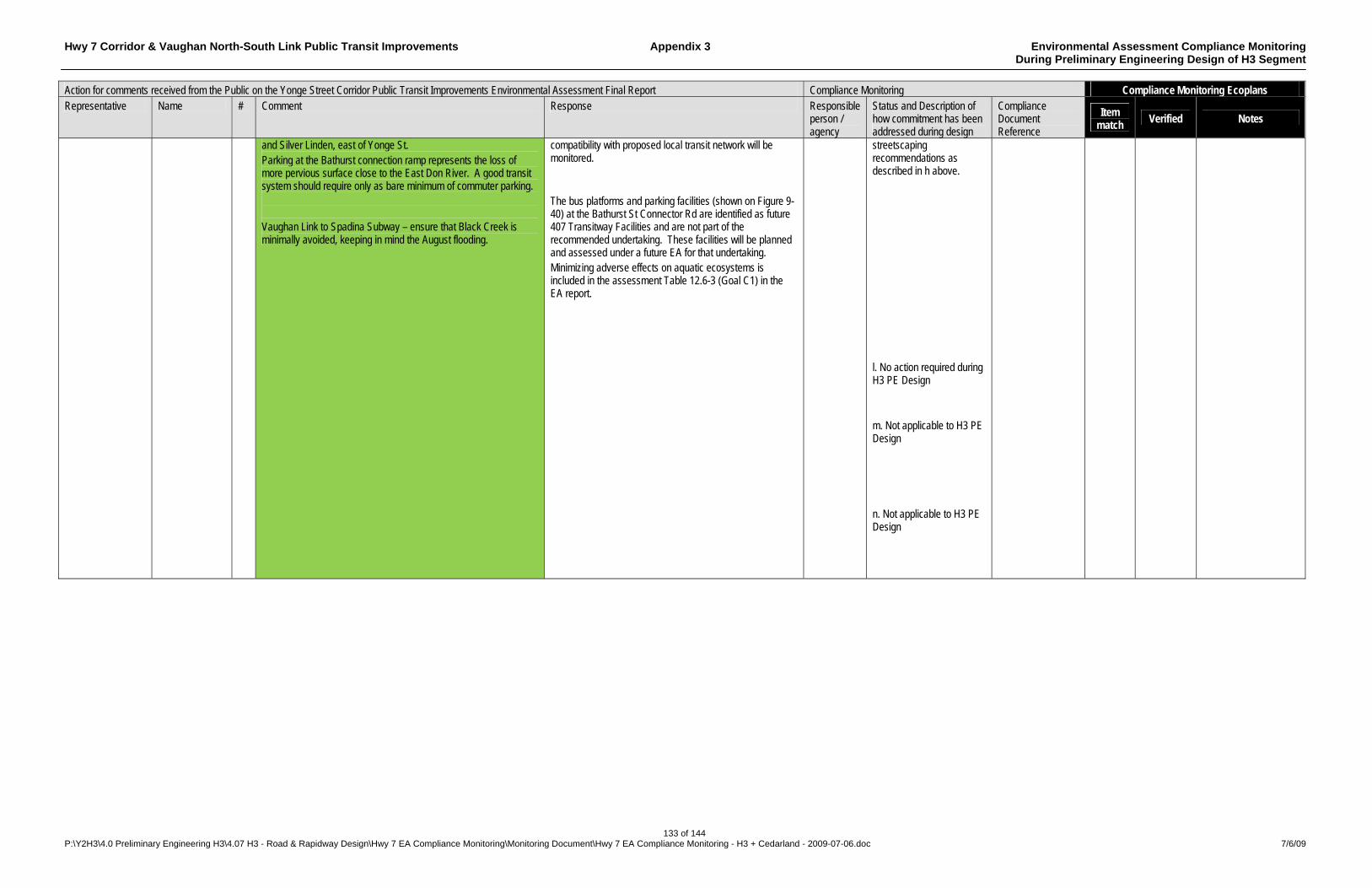
Hwy 7 Corridor & Vaughan North-South Link Public Transit Improvements Appendix 3 Environmental Assessment Compliance Monitoring During Preliminary Engineering Design of H3 Segment
133 of 144 P:\Y2H3\4.0 Preliminary Engineering H3\4.07 H3 - Road & Rapidway Design\Hwy 7 EA Compliance Monitoring\Monitoring Document\Hwy 7 EA Compliance Monitoring - H3 + Cedarland - 2009-07-06.doc 7/6/09
Action for comments received from the Public on the Yonge Street Corridor Public Transit Improvements Environmental Assessment Final Report Compliance Monitoring Compliance Monitoring Ecoplans Representative Name # Comment Response Responsible
person / agency
Status and Description of how commitment has been addressed during design
Compliance Document Reference
Item match Verified Notes
and Silver Linden, east of Yonge St. Parking at the Bathurst connection ramp represents the loss of more pervious surface close to the East Don River. A good transit system should require only as bare minimum of commuter parking. Vaughan Link to Spadina Subway – ensure that Black Creek is minimally avoided, keeping in mind the August flooding.
compatibility with proposed local transit network will be monitored. The bus platforms and parking facilities (shown on Figure 9-40) at the Bathurst St Connector Rd are identified as future 407 Transitway Facilities and are not part of the recommended undertaking. These facilities will be planned and assessed under a future EA for that undertaking. Minimizing adverse effects on aquatic ecosystems is included in the assessment Table 12.6-3 (Goal C1) in the EA report.
streetscaping recommendations as described in h above. l. No action required during H3 PE Design m. Not applicable to H3 PE Design n. Not applicable to H3 PE Design
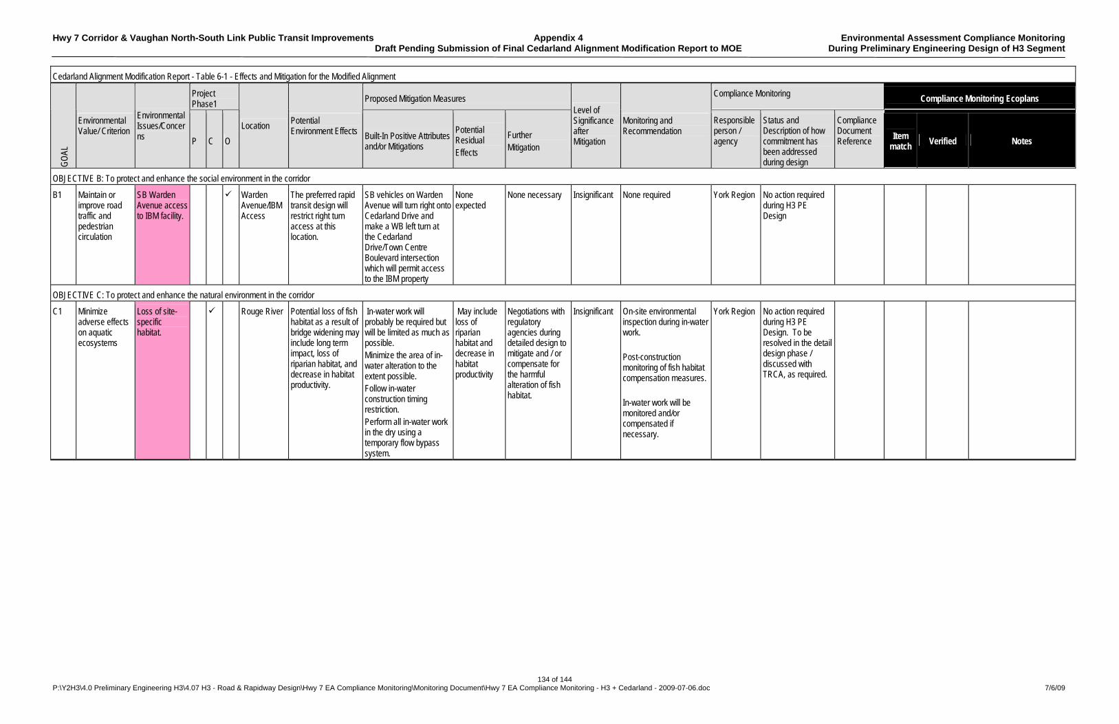
Hwy 7 Corridor & Vaughan North-South Link Public Transit Improvements Appendix 4 Environmental Assessment Compliance Monitoring Draft Pending Submission of Final Cedarland Alignment Modification Report to MOE During Preliminary Engineering Design of H3 Segment
134 of 144 P:\Y2H3\4.0 Preliminary Engineering H3\4.07 H3 - Road & Rapidway Design\Hwy 7 EA Compliance Monitoring\Monitoring Document\Hwy 7 EA Compliance Monitoring - H3 + Cedarland - 2009-07-06.doc 7/6/09
Cedarland Alignment Modification Report - Table 6-1 - Effects and Mitigation for the Modified Alignment
Project Phase1
Proposed Mitigation Measures Compliance Monitoring Compliance Monitoring Ecoplans
GO
AL
Environmental Value/ Criterion
Environmental Issues/Concerns P C O
Location Potential Environment Effects Built-In Positive Attributes
and/or Mitigations
Potential Residual Effects
Further Mitigation
Level of Significance after Mitigation
Monitoring and Recommendation
Responsible person / agency
Status and Description of how commitment has been addressed during design
Compliance Document Reference
Item match Verified Notes
OBJECTIVE B: To protect and enhance the social environment in the corridor
B1 Maintain or improve road traffic and pedestrian circulation
SB Warden Avenue access to IBM facility.
Warden Avenue/IBM Access
The preferred rapid transit design will restrict right turn access at this location.
SB vehicles on Warden Avenue will turn right onto Cedarland Drive and make a WB left turn at the Cedarland Drive/Town Centre Boulevard intersection which will permit access to the IBM property
None expected
None necessary Insignificant None required York Region No action required during H3 PE Design
OBJECTIVE C: To protect and enhance the natural environment in the corridor
C1 Minimize adverse effects on aquatic ecosystems
Loss of site-specific habitat.
Rouge River Potential loss of fish habitat as a result of bridge widening may include long term impact, loss of riparian habitat, and decrease in habitat productivity.
In-water work will probably be required but will be limited as much as possible. Minimize the area of in-water alteration to the extent possible. Follow in-water construction timing restriction. Perform all in-water work in the dry using a temporary flow bypass system.
May include loss of riparian habitat and decrease in habitat productivity
Negotiations with regulatory agencies during detailed design to mitigate and / or compensate for the harmful alteration of fish habitat.
Insignificant On-site environmental inspection during in-water work. Post-construction monitoring of fish habitat compensation measures. In-water work will be monitored and/or compensated if necessary.
York Region No action required during H3 PE Design. To be resolved in the detail design phase / discussed with TRCA, as required.
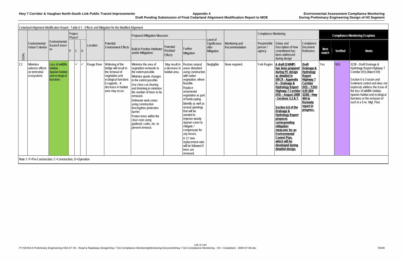
Hwy 7 Corridor & Vaughan North-South Link Public Transit Improvements Appendix 4 Environmental Assessment Compliance Monitoring Draft Pending Submission of Final Cedarland Alignment Modification Report to MOE During Preliminary Engineering Design of H3 Segment
135 of 144 P:\Y2H3\4.0 Preliminary Engineering H3\4.07 H3 - Road & Rapidway Design\Hwy 7 EA Compliance Monitoring\Monitoring Document\Hwy 7 EA Compliance Monitoring - H3 + Cedarland - 2009-07-06.doc 7/6/09
Cedarland Alignment Modification Report - Table 6-1 - Effects and Mitigation for the Modified Alignment
Project Phase1
Proposed Mitigation Measures Compliance Monitoring Compliance Monitoring Ecoplans
GO
AL
Environmental Value/ Criterion
Environmental Issues/Concerns P C O
Location Potential Environment Effects Built-In Positive Attributes
and/or Mitigations
Potential Residual Effects
Further Mitigation
Level of Significance after Mitigation
Monitoring and Recommendation
Responsible person / agency
Status and Description of how commitment has been addressed during design
Compliance Document Reference
Item match Verified Notes
C2 Minimize adverse effects on terrestrial ecosystems
Loss of wildlife habitat, riparian habitat and ecological functions
Rouge River Widening of the bridge will result in the removal of vegetation and ecological functions it supports. A decrease in habitat area may occur.
Minimize the area of vegetation removals to the extent possible. Minimize grade changes to the extent possible. Use close cut clearing and trimming to minimize the number of trees to be removed. Delineate work zones using construction fencing/tree protection barrier. Protect trees within the clear zone using guiderail, curbs, etc. to prevent removal.
May result in a decrease in habitat area.
Restore natural areas disturbed using construction with native vegetation, where feasible. Replace ornamental vegetation as part of landscaping. Identify as well as restore plantings that will be needed to improve woody riparian cover to mitigate / compensate for any losses. A 3:1 tree replacement ratio will be followed if trees are removed.
Negligible None required. York Region A draft (SWMP) has been prepared during PE design as detailed in DBCR - Appendix H – Drainage & Hydrology Report Highway 7 Corridor (H3) – August 2008 - Sections 5.2 & 7. Section 6.0 of the Drainage & Hydrology Report proposes corresponding mitigation measures for an Environmental Control Plan, which will be developed during detailed design.
Draft Drainage & Hydrology Report Highway 7 Corridor (H3) – Y2H3 4.05 (ID# 3230) - Hwy 404 to Kennedy report in progress.
Yes NSE 3230 - Draft Drainage & Hydrology Report Highway 7 Corridor (H3) (March 09) Section 6 is Erosion and Sediment control and does not expressly address the issue of the loss of wildlife habitat, riparian habitat and ecological functions or the inclusion of such in a Env. Mgt. Plan.
Note 1: P=Pre-Construction, C=Construction, O=Operation
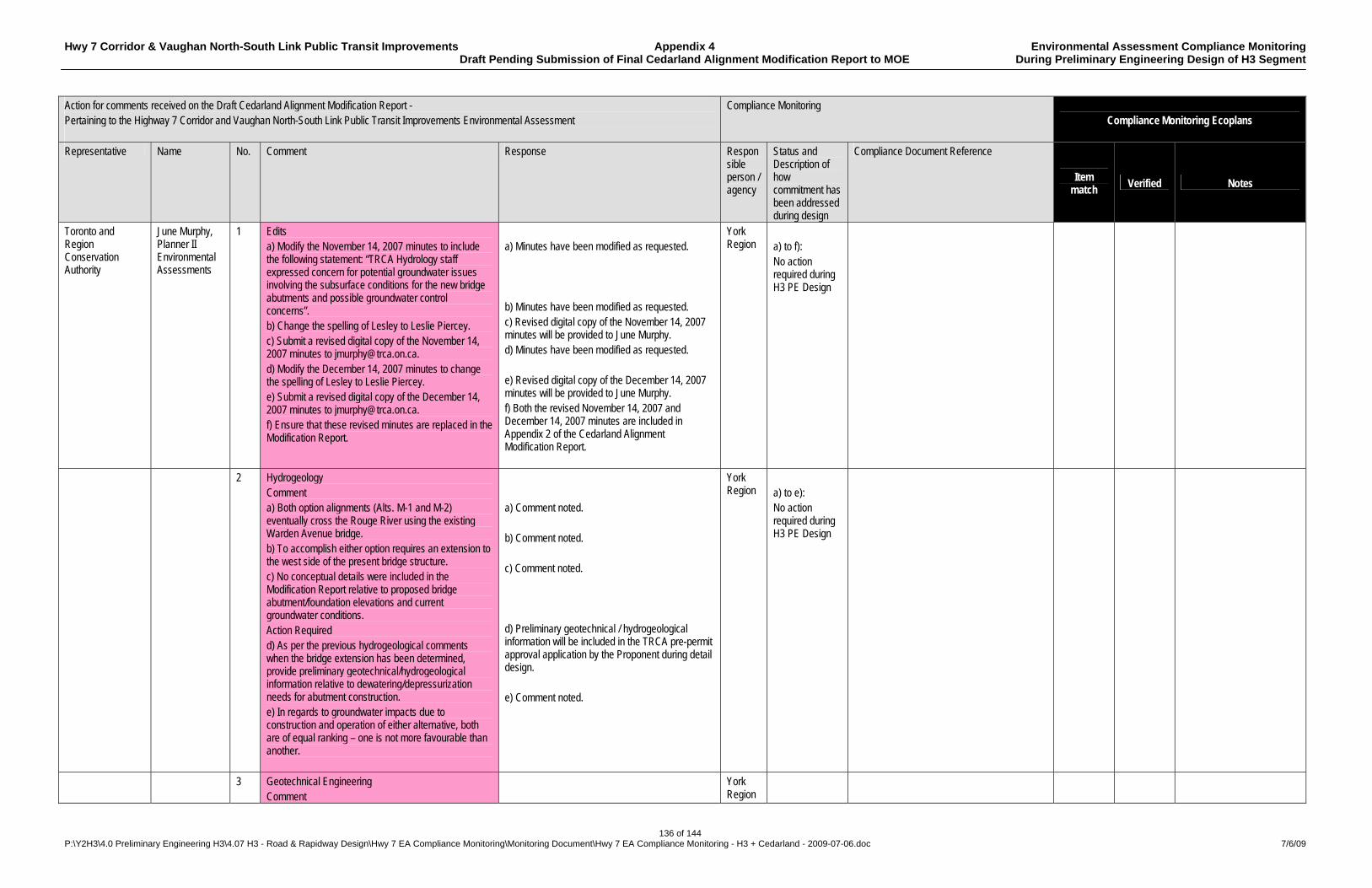
Hwy 7 Corridor & Vaughan North-South Link Public Transit Improvements Appendix 4 Environmental Assessment Compliance Monitoring Draft Pending Submission of Final Cedarland Alignment Modification Report to MOE During Preliminary Engineering Design of H3 Segment
136 of 144 P:\Y2H3\4.0 Preliminary Engineering H3\4.07 H3 - Road & Rapidway Design\Hwy 7 EA Compliance Monitoring\Monitoring Document\Hwy 7 EA Compliance Monitoring - H3 + Cedarland - 2009-07-06.doc 7/6/09
Action for comments received on the Draft Cedarland Alignment Modification Report - Pertaining to the Highway 7 Corridor and Vaughan North-South Link Public Transit Improvements Environmental Assessment
Compliance Monitoring Compliance Monitoring Ecoplans
Representative Name No. Comment Response Responsible person / agency
Status and Description of how commitment has been addressed during design
Compliance Document Reference
Item match Verified Notes
Toronto and Region Conservation Authority
June Murphy, Planner II Environmental Assessments
1 Edits a) Modify the November 14, 2007 minutes to include the following statement: “TRCA Hydrology staff expressed concern for potential groundwater issues involving the subsurface conditions for the new bridge abutments and possible groundwater control concerns”. b) Change the spelling of Lesley to Leslie Piercey. c) Submit a revised digital copy of the November 14, 2007 minutes to [email protected]. d) Modify the December 14, 2007 minutes to change the spelling of Lesley to Leslie Piercey. e) Submit a revised digital copy of the December 14, 2007 minutes to [email protected]. f) Ensure that these revised minutes are replaced in the Modification Report.
a) Minutes have been modified as requested. b) Minutes have been modified as requested. c) Revised digital copy of the November 14, 2007 minutes will be provided to June Murphy. d) Minutes have been modified as requested. e) Revised digital copy of the December 14, 2007 minutes will be provided to June Murphy. f) Both the revised November 14, 2007 and December 14, 2007 minutes are included in Appendix 2 of the Cedarland Alignment Modification Report.
York Region
a) to f): No action required during H3 PE Design
2 Hydrogeology Comment a) Both option alignments (Alts. M-1 and M-2) eventually cross the Rouge River using the existing Warden Avenue bridge. b) To accomplish either option requires an extension to the west side of the present bridge structure. c) No conceptual details were included in the Modification Report relative to proposed bridge abutment/foundation elevations and current groundwater conditions. Action Required d) As per the previous hydrogeological comments when the bridge extension has been determined, provide preliminary geotechnical/hydrogeological information relative to dewatering/depressurization needs for abutment construction. e) In regards to groundwater impacts due to construction and operation of either alternative, both are of equal ranking – one is not more favourable than another.
a) Comment noted. b) Comment noted. c) Comment noted. d) Preliminary geotechnical / hydrogeological information will be included in the TRCA pre-permit approval application by the Proponent during detail design. e) Comment noted.
York Region
a) to e): No action required during H3 PE Design
3 Geotechnical Engineering Comment
York Region

Hwy 7 Corridor & Vaughan North-South Link Public Transit Improvements Appendix 4 Environmental Assessment Compliance Monitoring Draft Pending Submission of Final Cedarland Alignment Modification Report to MOE During Preliminary Engineering Design of H3 Segment
137 of 144 P:\Y2H3\4.0 Preliminary Engineering H3\4.07 H3 - Road & Rapidway Design\Hwy 7 EA Compliance Monitoring\Monitoring Document\Hwy 7 EA Compliance Monitoring - H3 + Cedarland - 2009-07-06.doc 7/6/09
Action for comments received on the Draft Cedarland Alignment Modification Report - Pertaining to the Highway 7 Corridor and Vaughan North-South Link Public Transit Improvements Environmental Assessment
Compliance Monitoring Compliance Monitoring Ecoplans
Representative Name No. Comment Response Responsible person / agency
Status and Description of how commitment has been addressed during design
Compliance Document Reference
Item match
Verified Notes
a) There are no outstanding geotechnical engineering issues at this stage of the proposal.
a) Comment noted. Detailed geotechnical reports will be distributed to TRCA during detail design.
a) No action required during H3 PE Design
4 Ecology Comment a) The proposed change to the alignment along Cedarland Drive/Warden Avenue is generally acceptable from an ecological perspective, however there are a number of edits in the report that should be corrected as noted.
a) Comment noted.
York Region
a) No action required during H3 PE Design
5 Ecology-natural areas – Page 5 Comment a) Page 5 of the report states that “there are no designated natural areas within the area considered for modified alignment alternatives…” b) This is not accurate as the area is identified as part of TRCA’s Terrestrial Natural Heritage System, and the area presently supports existing natural cover, including remnant woodlands and meadow areas within the valley corridor immediately adjacent to Warden Avenue. Action Required c) This section needs to be revised to more fully describe the existing natural environment. d) It would be correct to state that there are no Environmentally Sensitive Areas, Areas of Natural and Scientific Interest, Provincially Significant Wetlands, Locally Significant Wetlands or other Provincially or Federally designated natural areas (as it relates to the Provincial Policy Statement within the modified alignment area). e) However, the importance of the remnant natural, successional processes and wildlife within this reach of the system. f) Identify the location of the remnant natural areas that are present and include them on page 5.
a) The statement has been deleted from the report. b) A modified statement has been incorporated in the report. c) A summary of Ecological Land Classification Vegetation Communities within the Alignment Modification Area has been added. If required, further information will be provided as part of TRCA pre-permit approval submitted during detail design. d) Corrected statement included in the report. e) Comment noted. f) A summary of Ecological Land Classification Vegetation Communities within the Alignment Modification Area has been added. If required, further information will be provided as part of TRCA pre-permit approval submitted during detail design.
York Region
a) to f): No action required during H3 PE Design
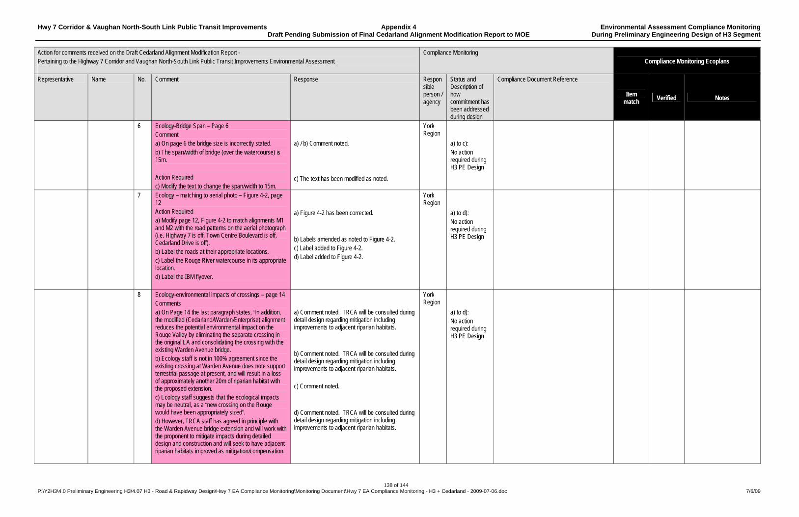
Hwy 7 Corridor & Vaughan North-South Link Public Transit Improvements Appendix 4 Environmental Assessment Compliance Monitoring Draft Pending Submission of Final Cedarland Alignment Modification Report to MOE During Preliminary Engineering Design of H3 Segment
138 of 144 P:\Y2H3\4.0 Preliminary Engineering H3\4.07 H3 - Road & Rapidway Design\Hwy 7 EA Compliance Monitoring\Monitoring Document\Hwy 7 EA Compliance Monitoring - H3 + Cedarland - 2009-07-06.doc 7/6/09
Action for comments received on the Draft Cedarland Alignment Modification Report - Pertaining to the Highway 7 Corridor and Vaughan North-South Link Public Transit Improvements Environmental Assessment
Compliance Monitoring Compliance Monitoring Ecoplans
Representative Name No. Comment Response Responsible person / agency
Status and Description of how commitment has been addressed during design
Compliance Document Reference
Item match
Verified Notes
6 Ecology-Bridge Span – Page 6 Comment a) On page 6 the bridge size is incorrectly stated. b) The span/width of bridge (over the watercourse) is 15m. Action Required c) Modify the text to change the span/width to 15m.
a) / b) Comment noted. c) The text has been modified as noted.
York Region
a) to c): No action required during H3 PE Design
7 Ecology – matching to aerial photo – Figure 4-2, page 12 Action Required a) Modify page 12, Figure 4-2 to match alignments M1 and M2 with the road patterns on the aerial photograph (i.e. Highway 7 is off, Town Centre Boulevard is off, Cedarland Drive is off). b) Label the roads at their appropriate locations. c) Label the Rouge River watercourse in its appropriate location. d) Label the IBM flyover.
a) Figure 4-2 has been corrected. b) Labels amended as noted to Figure 4-2. c) Label added to Figure 4-2. d) Label added to Figure 4-2.
York Region
a) to d): No action required during H3 PE Design
8 Ecology-environmental impacts of crossings – page 14 Comments a) On Page 14 the last paragraph states, “in addition, the modified (Cedarland/Warden/Enterprise) alignment reduces the potential environmental impact on the Rouge Valley by eliminating the separate crossing in the original EA and consolidating the crossing with the existing Warden Avenue bridge. b) Ecology staff is not in 100% agreement since the existing crossing at Warden Avenue does note support terrestrial passage at present, and will result in a loss of approximately another 20m of riparian habitat with the proposed extension. c) Ecology staff suggests that the ecological impacts may be neutral, as a “new crossing on the Rouge would have been appropriately sized”. d) However, TRCA staff has agreed in principle with the Warden Avenue bridge extension and will work with the proponent to mitigate impacts during detailed design and construction and will seek to have adjacent riparian habitats improved as mitigation/compensation.
a) Comment noted. TRCA will be consulted during detail design regarding mitigation including improvements to adjacent riparian habitats. b) Comment noted. TRCA will be consulted during detail design regarding mitigation including improvements to adjacent riparian habitats. c) Comment noted. d) Comment noted. TRCA will be consulted during detail design regarding mitigation including improvements to adjacent riparian habitats.
York Region
a) to d): No action required during H3 PE Design
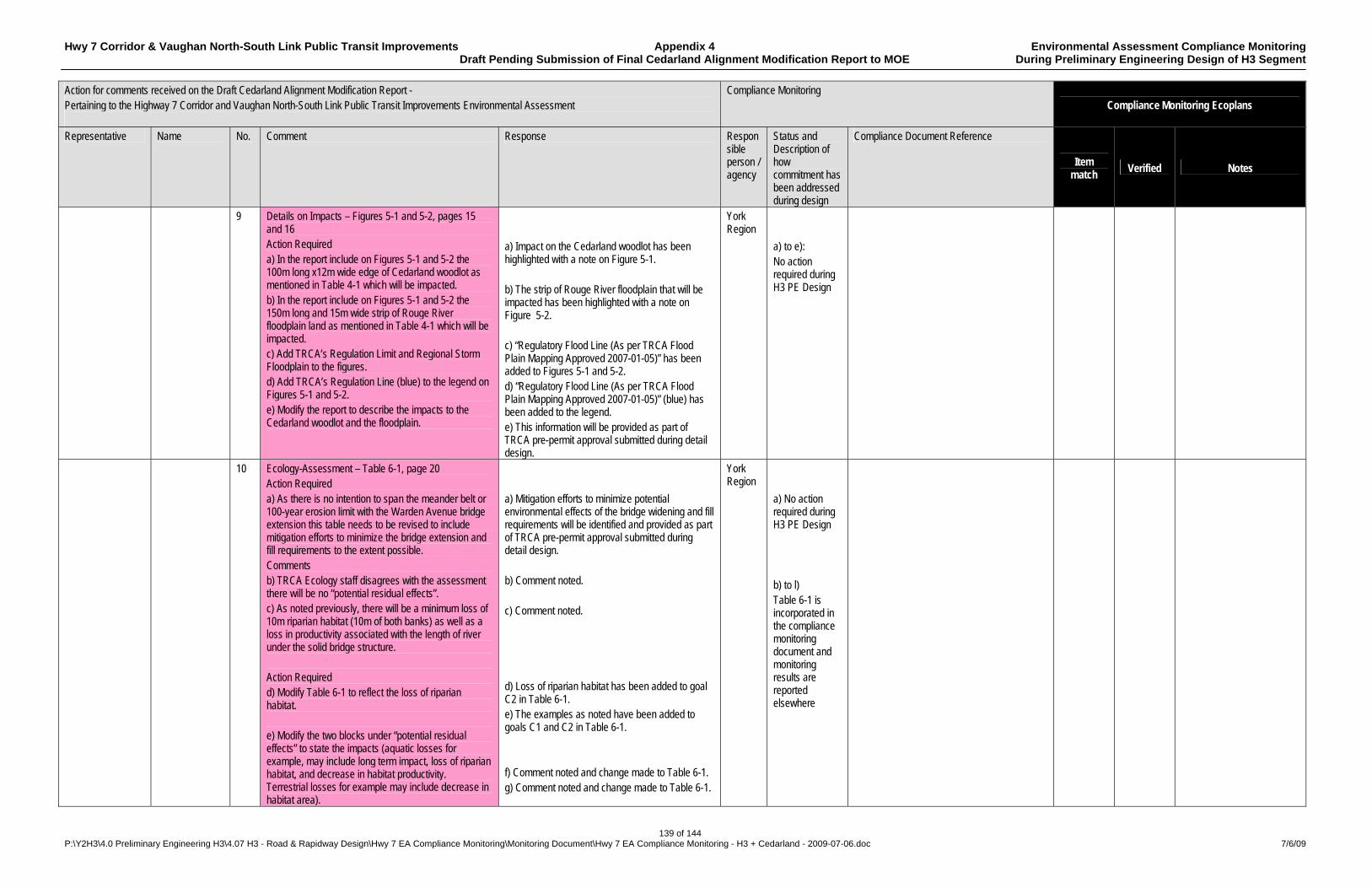
Hwy 7 Corridor & Vaughan North-South Link Public Transit Improvements Appendix 4 Environmental Assessment Compliance Monitoring Draft Pending Submission of Final Cedarland Alignment Modification Report to MOE During Preliminary Engineering Design of H3 Segment
139 of 144 P:\Y2H3\4.0 Preliminary Engineering H3\4.07 H3 - Road & Rapidway Design\Hwy 7 EA Compliance Monitoring\Monitoring Document\Hwy 7 EA Compliance Monitoring - H3 + Cedarland - 2009-07-06.doc 7/6/09
Action for comments received on the Draft Cedarland Alignment Modification Report - Pertaining to the Highway 7 Corridor and Vaughan North-South Link Public Transit Improvements Environmental Assessment
Compliance Monitoring Compliance Monitoring Ecoplans
Representative Name No. Comment Response Responsible person / agency
Status and Description of how commitment has been addressed during design
Compliance Document Reference
Item match
Verified Notes
9 Details on Impacts – Figures 5-1 and 5-2, pages 15 and 16 Action Required a) In the report include on Figures 5-1 and 5-2 the 100m long x12m wide edge of Cedarland woodlot as mentioned in Table 4-1 which will be impacted. b) In the report include on Figures 5-1 and 5-2 the 150m long and 15m wide strip of Rouge River floodplain land as mentioned in Table 4-1 which will be impacted. c) Add TRCA’s Regulation Limit and Regional Storm Floodplain to the figures. d) Add TRCA’s Regulation Line (blue) to the legend on Figures 5-1 and 5-2. e) Modify the report to describe the impacts to the Cedarland woodlot and the floodplain.
a) Impact on the Cedarland woodlot has been highlighted with a note on Figure 5-1. b) The strip of Rouge River floodplain that will be impacted has been highlighted with a note on Figure 5-2. c) “Regulatory Flood Line (As per TRCA Flood Plain Mapping Approved 2007-01-05)” has been added to Figures 5-1 and 5-2. d) “Regulatory Flood Line (As per TRCA Flood Plain Mapping Approved 2007-01-05)” (blue) has been added to the legend. e) This information will be provided as part of TRCA pre-permit approval submitted during detail design.
York Region
a) to e): No action required during H3 PE Design
10 Ecology-Assessment – Table 6-1, page 20 Action Required a) As there is no intention to span the meander belt or 100-year erosion limit with the Warden Avenue bridge extension this table needs to be revised to include mitigation efforts to minimize the bridge extension and fill requirements to the extent possible. Comments b) TRCA Ecology staff disagrees with the assessment there will be no “potential residual effects”. c) As noted previously, there will be a minimum loss of 10m riparian habitat (10m of both banks) as well as a loss in productivity associated with the length of river under the solid bridge structure. Action Required d) Modify Table 6-1 to reflect the loss of riparian habitat. e) Modify the two blocks under “potential residual effects” to state the impacts (aquatic losses for example, may include long term impact, loss of riparian habitat, and decrease in habitat productivity. Terrestrial losses for example may include decrease in habitat area).
a) Mitigation efforts to minimize potential environmental effects of the bridge widening and fill requirements will be identified and provided as part of TRCA pre-permit approval submitted during detail design. b) Comment noted. c) Comment noted. d) Loss of riparian habitat has been added to goal C2 in Table 6-1. e) The examples as noted have been added to goals C1 and C2 in Table 6-1. f) Comment noted and change made to Table 6-1. g) Comment noted and change made to Table 6-1.
York Region
a) No action required during H3 PE Design b) to l) Table 6-1 is incorporated in the compliance monitoring document and monitoring results are reported elsewhere
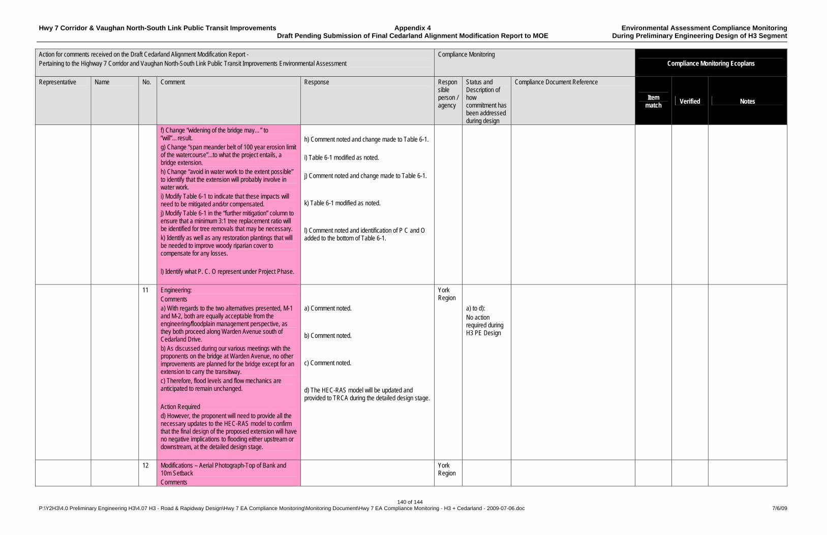
Hwy 7 Corridor & Vaughan North-South Link Public Transit Improvements Appendix 4 Environmental Assessment Compliance Monitoring Draft Pending Submission of Final Cedarland Alignment Modification Report to MOE During Preliminary Engineering Design of H3 Segment
140 of 144 P:\Y2H3\4.0 Preliminary Engineering H3\4.07 H3 - Road & Rapidway Design\Hwy 7 EA Compliance Monitoring\Monitoring Document\Hwy 7 EA Compliance Monitoring - H3 + Cedarland - 2009-07-06.doc 7/6/09
Action for comments received on the Draft Cedarland Alignment Modification Report - Pertaining to the Highway 7 Corridor and Vaughan North-South Link Public Transit Improvements Environmental Assessment
Compliance Monitoring Compliance Monitoring Ecoplans
Representative Name No. Comment Response Responsible person / agency
Status and Description of how commitment has been addressed during design
Compliance Document Reference
Item match
Verified Notes
f) Change “widening of the bridge may…” to “will”…result. g) Change “span meander belt of 100 year erosion limit of the watercourse”...to what the project entails, a bridge extension. h) Change “avoid in water work to the extent possible” to identify that the extension will probably involve in water work. i) Modify Table 6-1 to indicate that these impacts will need to be mitigated and/or compensated. j) Modify Table 6-1 in the “further mitigation” column to ensure that a minimum 3:1 tree replacement ratio will be identified for tree removals that may be necessary. k) Identify as well as any restoration plantings that will be needed to improve woody riparian cover to compensate for any losses. l) Identify what P. C. O represent under Project Phase.
h) Comment noted and change made to Table 6-1. i) Table 6-1 modified as noted. j) Comment noted and change made to Table 6-1. k) Table 6-1 modified as noted. l) Comment noted and identification of P C and O added to the bottom of Table 6-1.
11 Engineering: Comments a) With regards to the two alternatives presented, M-1 and M-2, both are equally acceptable from the engineering/floodplain management perspective, as they both proceed along Warden Avenue south of Cedarland Drive. b) As discussed during our various meetings with the proponents on the bridge at Warden Avenue, no other improvements are planned for the bridge except for an extension to carry the transitway. c) Therefore, flood levels and flow mechanics are anticipated to remain unchanged. Action Required d) However, the proponent will need to provide all the necessary updates to the HEC-RAS model to confirm that the final design of the proposed extension will have no negative implications to flooding either upstream or downstream, at the detailed design stage.
a) Comment noted. b) Comment noted. c) Comment noted. d) The HEC-RAS model will be updated and provided to TRCA during the detailed design stage.
York Region
a) to d): No action required during H3 PE Design
12 Modifications – Aerial Photograph-Top of Bank and 10m Setback Comments
York Region
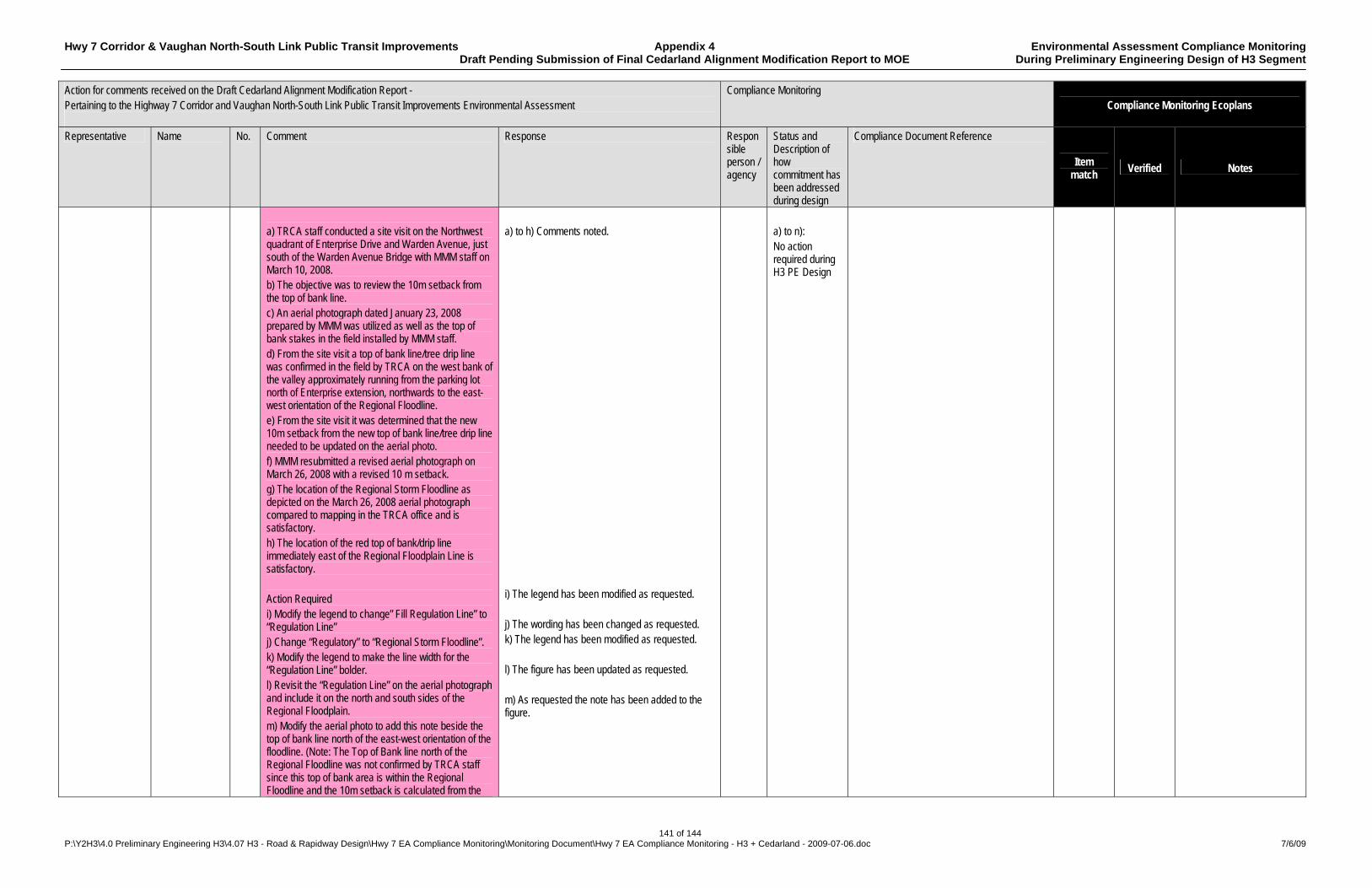
Hwy 7 Corridor & Vaughan North-South Link Public Transit Improvements Appendix 4 Environmental Assessment Compliance Monitoring Draft Pending Submission of Final Cedarland Alignment Modification Report to MOE During Preliminary Engineering Design of H3 Segment
141 of 144 P:\Y2H3\4.0 Preliminary Engineering H3\4.07 H3 - Road & Rapidway Design\Hwy 7 EA Compliance Monitoring\Monitoring Document\Hwy 7 EA Compliance Monitoring - H3 + Cedarland - 2009-07-06.doc 7/6/09
Action for comments received on the Draft Cedarland Alignment Modification Report - Pertaining to the Highway 7 Corridor and Vaughan North-South Link Public Transit Improvements Environmental Assessment
Compliance Monitoring Compliance Monitoring Ecoplans
Representative Name No. Comment Response Responsible person / agency
Status and Description of how commitment has been addressed during design
Compliance Document Reference
Item match
Verified Notes
a) TRCA staff conducted a site visit on the Northwest quadrant of Enterprise Drive and Warden Avenue, just south of the Warden Avenue Bridge with MMM staff on March 10, 2008. b) The objective was to review the 10m setback from the top of bank line. c) An aerial photograph dated January 23, 2008 prepared by MMM was utilized as well as the top of bank stakes in the field installed by MMM staff. d) From the site visit a top of bank line/tree drip line was confirmed in the field by TRCA on the west bank of the valley approximately running from the parking lot north of Enterprise extension, northwards to the east-west orientation of the Regional Floodline. e) From the site visit it was determined that the new 10m setback from the new top of bank line/tree drip line needed to be updated on the aerial photo. f) MMM resubmitted a revised aerial photograph on March 26, 2008 with a revised 10 m setback. g) The location of the Regional Storm Floodline as depicted on the March 26, 2008 aerial photograph compared to mapping in the TRCA office and is satisfactory. h) The location of the red top of bank/drip line immediately east of the Regional Floodplain Line is satisfactory. Action Required i) Modify the legend to change” Fill Regulation Line” to “Regulation Line” j) Change “Regulatory” to “Regional Storm Floodline”. k) Modify the legend to make the line width for the “Regulation Line” bolder. l) Revisit the “Regulation Line” on the aerial photograph and include it on the north and south sides of the Regional Floodplain. m) Modify the aerial photo to add this note beside the top of bank line north of the east-west orientation of the floodline. (Note: The Top of Bank line north of the Regional Floodline was not confirmed by TRCA staff since this top of bank area is within the Regional Floodline and the 10m setback is calculated from the
a) to h) Comments noted. i) The legend has been modified as requested. j) The wording has been changed as requested. k) The legend has been modified as requested. l) The figure has been updated as requested. m) As requested the note has been added to the figure.
a) to n): No action required during H3 PE Design
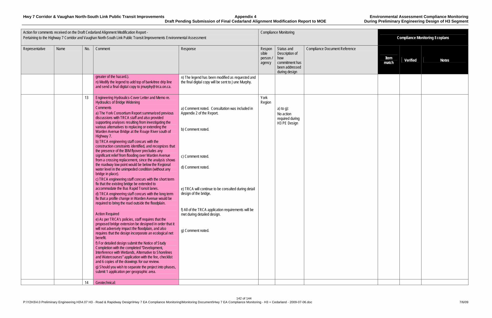
Hwy 7 Corridor & Vaughan North-South Link Public Transit Improvements Appendix 4 Environmental Assessment Compliance Monitoring Draft Pending Submission of Final Cedarland Alignment Modification Report to MOE During Preliminary Engineering Design of H3 Segment
142 of 144 P:\Y2H3\4.0 Preliminary Engineering H3\4.07 H3 - Road & Rapidway Design\Hwy 7 EA Compliance Monitoring\Monitoring Document\Hwy 7 EA Compliance Monitoring - H3 + Cedarland - 2009-07-06.doc 7/6/09
Action for comments received on the Draft Cedarland Alignment Modification Report - Pertaining to the Highway 7 Corridor and Vaughan North-South Link Public Transit Improvements Environmental Assessment
Compliance Monitoring Compliance Monitoring Ecoplans
Representative Name No. Comment Response Responsible person / agency
Status and Description of how commitment has been addressed during design
Compliance Document Reference
Item match
Verified Notes
greater of the hazard.). n) Modify the legend to add top of bank/tree drip line and send a final digital copy to [email protected].
n) The legend has been modified as requested and the final digital copy will be sent to June Murphy.
13 Engineering Hydraulics-Cover Letter and Memo re. Hydraulics of Bridge Widening Comments a) The York Consortium Report summarized previous discussions with TRCA staff and also provided supporting analyses resulting from investigating the various alternatives to replacing or extending the Warden Avenue Bridge at the Rouge River south of Highway 7. b) TRCA engineering staff concurs with the construction constraints identified, and recognizes that the presence of the IBM flyover precludes any significant relief from flooding over Warden Avenue from a crossing replacement, since the analysis shows the roadway low point would be below the Regional water level in the unimpeded condition (without any bridge in place). c) TRCA engineering staff concurs with the short term fix that the existing bridge be extended to accommodate the Bus Rapid Transit lanes. d) TRCA engineering staff concurs with the long term fix that a profile change in Warden Avenue would be required to bring the road outside the floodplain. Action Required e) As per TRCA’s policies, staff requires that the proposed bridge extension be designed in order that it will not adversely impact the floodplain, and also requires that the design incorporate an ecological net benefit. f) For detailed design submit the Notice of Study Completion with the completed “Development, Interference with Wetlands, Alternative to Shorelines and Watercourses” application with the fee, checklist and 6 copies of the drawings for our review. g) Should you wish to separate the project into phases, submit 1 application per geographic area.
a) Comment noted. Consultation was included in Appendix 2 of the Report. b) Comment noted. c) Comment noted. d) Comment noted. e) TRCA will continue to be consulted during detail design of the bridge. f) All of the TRCA application requirements will be met during detailed design. g) Comment noted.
York Region
a) to g): No action required during H3 PE Design
14 Geotechnical:

Hwy 7 Corridor & Vaughan North-South Link Public Transit Improvements Appendix 4 Environmental Assessment Compliance Monitoring Draft Pending Submission of Final Cedarland Alignment Modification Report to MOE During Preliminary Engineering Design of H3 Segment
143 of 144 P:\Y2H3\4.0 Preliminary Engineering H3\4.07 H3 - Road & Rapidway Design\Hwy 7 EA Compliance Monitoring\Monitoring Document\Hwy 7 EA Compliance Monitoring - H3 + Cedarland - 2009-07-06.doc 7/6/09
Action for comments received on the Draft Cedarland Alignment Modification Report - Pertaining to the Highway 7 Corridor and Vaughan North-South Link Public Transit Improvements Environmental Assessment
Compliance Monitoring Compliance Monitoring Ecoplans
Representative Name No. Comment Response Responsible person / agency
Status and Description of how commitment has been addressed during design
Compliance Document Reference
Item match
Verified Notes
Comments a) There are no Geotechnical Engineering issues with the submissions to date, however, comments will follow in the detail design stage.
a) Comment noted. TRCA will be consulted during detail design phase/
a) No action required during H3 PE Design
15 Hydrogeology: Comments a) Based on the material submitted, the proponent envisages an extension of the western side of the existing bridge structure to accommodate a rapid transit bus lane. b) The submitted documentation focused on scenarios of bridge design and relative surface water flow and surface water back-up behind the specific bridge design. c) At this time, there are no groundwater issues from the submitted hydraulic report. Action Required: d) During detailed design when the appropriate bridge extension has been determined, provide the preliminary geotechnical/hydrogeological information relative to dewatering/depressurization needs for abutment construction. e) With the submission of the “Development” application, provide 2 copies of the geotechnical/hydrogeological reports. f) Provide a summary of the construction of the Warden Avenue Bridge extensions since TRCA staff recalls a groundwater/construction issue during that project. g) Contact Peter Cholewa, RMOY, for further details on the recent Warden Avenue Bridge extensions.
a) Comment noted. The transit lanes will be added to the west side of the existing bridge structure. b) Comment noted. c) Comment noted. d) The preliminary geotechnical/hydrogeological information prepared during detailed design will be provided to TRCA. This will include information related to dewatering and depressurization needs for the construction of the abutment. e) Comment noted. When the Proponent provides TRCA with the application, two copies of the reports will be provided. f) The Proponent will review reports from the construction of the Warden Avenue bridge extension and discuss with Peter Cholewa during detail design. g) The Proponent will contact Peter Cholewa as suggested during detail design.
York Region
a) to g): No action required during H3 PE Design
Ministry of the Environment– Environmental Assessment and Approvals Branch
Shereen Amin, Project Officer, EA Project Coordination
1 Section 1.1 Rephrase first sentence to read “York Region considers the local modification to the alignment to be a significant change from what was approved in the EA. However, York Region has determined that the modification does not alter the net effects of the undertaking and can therefore consider this modification to have neutral environmental net effects”.
Comment noted and incorporated in Section 1.1. York Region
No action required during H3 PE Design
2 Page 21, Section 7.0 A table of meetings with dates and attendees has York No action
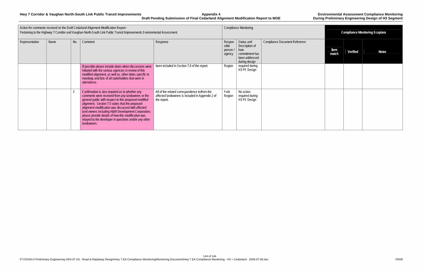
Hwy 7 Corridor & Vaughan North-South Link Public Transit Improvements Appendix 4 Environmental Assessment Compliance Monitoring Draft Pending Submission of Final Cedarland Alignment Modification Report to MOE During Preliminary Engineering Design of H3 Segment
144 of 144 P:\Y2H3\4.0 Preliminary Engineering H3\4.07 H3 - Road & Rapidway Design\Hwy 7 EA Compliance Monitoring\Monitoring Document\Hwy 7 EA Compliance Monitoring - H3 + Cedarland - 2009-07-06.doc 7/6/09
Action for comments received on the Draft Cedarland Alignment Modification Report - Pertaining to the Highway 7 Corridor and Vaughan North-South Link Public Transit Improvements Environmental Assessment
Compliance Monitoring Compliance Monitoring Ecoplans
Representative Name No. Comment Response Responsible person / agency
Status and Description of how commitment has been addressed during design
Compliance Document Reference
Item match
Verified Notes
If possible please include dates when discussions were initiated with the various agencies in review of this modified alignment, as well as, other dates specific to meetings and lists of all stakeholders that were in attendance.
been included in Section 7.0 of the report. Region required during H3 PE Design
3 Confirmation is also required as to whether any comments were received from any landowners or the general public with respect to this proposed modified alignment. Section 7.5 states that the proposed alignment modification was discussed with affected land owners including H&W Development Corporation; please provide details of how this modification was relayed to the developer in questions and/or any other landowners.
All of the related correspondence to/from the affected landowners is included in Appendix 2 of the report.
York Region
No action required during H3 PE Design