Embed Size (px)
Citation preview

NOAA Technical Report NOS CO-OPS 069
COASTAL OCEAN MODELING FRAMEWORK ON NOAA’S HIGH PERFORMANCE COMPUTER (COMF-HPC)
Silver Spring, Maryland March, 2014
noaa National Oceanic and Atmospheric Administration U.S. DEPARTMENT OF COMMERCE National Ocean Service Center for Operational Oceanographic Products and Services

Center for Operational Oceanographic Products and Services
National Ocean Service National Oceanic and Atmospheric Administration
U.S. Department of Commerce
The National Ocean Service (NOS) Center for Operational Oceanographic Products and Services (CO-OPS) provides the National infrastructure, science, and technical expertise to collect and distribute observations and predictions of water levels and currents to ensure safe, efficient and environmentally sound maritime commerce. The Center provides the set of water level and tidal current products required to support NOS’ Strategic Plan mission requirements, and to assist in providing operational oceanographic data/products required by NOAA’s other Strategic Plan themes. For example, CO-OPS provides data and products required by the National Weather Service to meet its flood and tsunami warning responsibilities. The Center manages the National Water Level Observation Network (NWLON), a national network of Physical Oceanographic Real-Time Systems (PORTS®) in major U. S. harbors, and the National Current Observation Program consisting of current surveys in near shore and coastal areas utilizing bottom mounted platforms, subsurface buoys, horizontal sensors and quick response real time buoys. The Center: establishes standards for the collection and processing of water level and current data; collects and documents user requirements which serve as the foundation for all resulting program activities; designs new and/or improved oceanographic observing systems; designs software to improve CO-OPS’ data processing capabilities; maintains and operates oceanographic observing systems; performs operational data analysis/quality control; and produces/disseminates oceanographic products.

NOAA Technical Report NOS CO-OPS 069
COASTAL OCEAN MODELING FRAMEWORK ON NOAA’S HIGH PERFORMANCE COMPUTER (COMF-HPC)
Aijun Zhang NOAA/NOS/Center for Operational Oceanographic Products and Services Zizang Yang NOAA/NOS/OCS/Coast Survey Development Laboratory March, 2014
U.S.DEPARTMENT OF COMMERCE Penny Pritzker, Secretary National Oceanic and Atmospheric Administration Dr. Kathryn Sullivan Acting NOAA Administrator National Ocean Service Holly Bamford, Assistant Administrator Center for Operational Oceanographic Products and Services Richard Edwing, Director

2

TABLE OF CONTENTS LIST OF TABLES ......................................................................................................................... iii LIST OF FIGURES ....................................................................................................................... iii LIST OF ACRONYMS ................................................................................................................. iv LIST OF SYMBOLS ...................................................................................................................... v LIST OF VARIABLES.................................................................................................................. vi EXECUTIVE SUMMARY .......................................................................................................... vii 1. INTRODUCTION .............................................................................................................. 1 1.1. Background ......................................................................................................................... 1 1.2. Procedures of OFS Operations............................................................................................ 2 1.3. Architecture of COMF-HPC .............................................................................................. 6 2. DATA DESCRIPTION ...................................................................................................... 9 2.1. NCEP Data Tank Files ........................................................................................................ 9 2.2. Shared Static Dataset ........................................................................................................ 11 2.3. Static Dataset for specific OFS ......................................................................................... 11 3. OFS CONTROL FILES ................................................................................................... 13 3.1. Main Control File .............................................................................................................. 13 3.2. Control file for Open Boundary Condition Generation .................................................... 17 3.3. Control file for River Forcing Generation ........................................................................ 19 4. SCRIPTS AND FORTRAN PROGRAMS ..................................................................... 23 4.1. Scripts Library .................................................................................................................. 23 4.1.1. sms .................................................................................................................................. 23 4.1.2. jobs .................................................................................................................................. 24 4.1.3. scripts ............................................................................................................................... 25 4.1.4. ush .................................................................................................................................... 26 4.2. FORTRAN Programs........................................................................................................ 31 4.2.1. nos_ofs_utility.fd ........................................................................................................... 31 4.2.2. nos_ofs_reformat_ROMS_CTL.fd ................................................................................ 32 4.2.3. nos_ofs_read_restart.fd ................................................................................................... 33 4.2.4. nos_ofs_read_restart_fvcom.fd ....................................................................................... 33 4.2.5. nos_ofs_read_restart_selfe.fd ......................................................................................... 34 4.2.6. nos_ofs_met_file_search.fd ............................................................................................ 34 4.2.7. nos_ofs_create_forcing_met.fd ....................................................................................... 35 4.2.8. nos_ofs_create_forcing_met_fvcom.fd .......................................................................... 36 4.2.9. nos_ofs_create_forcing_river.fd ..................................................................................... 36 4.2.10 nos_ofs_create_forcing_obc_tides.fd .............................................................................. 37 4.2.11. nos_ofs_create_forcing_obc.fd ........................................................................................ 38 4.2.12. nos_ofs_create_forcing_obc_fvcom.fd ............................................................................ 39 4.2.13 nos_ofs_create_forcing_obc_selfe.fd .............................................................................. 40
i

5. IMPLEMENTATION OF OFS OPERATIONS .............................................................. 43 5.1. Creation of Model Input Files ........................................................................................... 43 5.1.1. File Description .............................................................................................................. 43 5.1.2. Flow Chart of Execution ................................................................................................ 45 5.1.3. Generating Meteorological Forcing File ......................................................................... 47 5.1.4. Generating River Forcing File ........................................................................................ 47 5.1.5. Gnerating Open Boundary Condition File ...................................................................... 48 5.1.6. Generating Model Runtime Input File ............................................................................ 49 5.2. Execution of Nowcast/Forecast Simulations .................................................................... 51 6. WORK DIRECTORY ...................................................................................................... 53 6.1. Model Input Data Files ..................................................................................................... 53 6.2. Temporary Input Files for Forcing File Preparation ........................................................ 54 6.3. Ocean Model Input File ................................................................................................... 54 6.4. Temporary Log Files ........................................................................................................ 55 7. FILE ARCHIVING ........................................................................................................... 57 8. TROUBLE SHOOTING ................................................................................................... 59 9. CONCLUSIONS............................................................................................................... 63 ACKNOWLEDGEMENT ............................................................................................................ 63 REFERENCES ............................................................................................................................. 63 Appendix 1 Example File of Fortran_met.ctl ............................................................................... 65 Appendix 2 Example File of Fortran_OBC.ctl ............................................................................. 67 Appendix 3 Example File of Fortran_Tide.ctl .............................................................................. 69 Appendix 4 Example File of Fortran_River.ctl ........................................................................... 71 Appendix 5 Example File of Fortran_file_search.ctl ................................................................... 73
ii

LIST OF TABLES
Table 1.1. The OFS launch time at each cycle in UTC ................................................................ 4
Table 1.2. Name list of COMF-HPC directories ......................................................................... 6
Table 2.1. Parameters and data formats of various meteorological products ............................. 10
Table 2.2. The availabiity timeline in UTC of the NCEP data tank products ............................ 11
LIST OF FIGURES
Figure 1.1. The logic of OFS operational procedures. ................................................................... 4
Figure 1.2. The COMF-HPC core directory hierarchy. The names listed in the thick-line boxes are those mandated by NCO. ....................................................................................... 7
Figure 5.1. Diagram of execution of one cycle nowcast/forecast run ........................................ 44
Figure 5.2. Logic procedure to prepare model forcing input files ............................................... 46
Figure 5.3. Procedures to create the surface forcing file for nowcast runs .................................. 49
Figure 5.4. Procedures to create river forcing files ...................................................................... 49
Figure 5.5. Procedures to create the model open boundary forcing files .................................... 50
Figure 5.6. Procedures to reformat the nowcast run ROMS input files ....................................... 50
Figure 5.7. Diagram of nowcast/forecast simulations run ........................................................... 52
iii

LIST OF ACRONYMS
ADCIRC ADvanced CIRCulation model BUFR Binary Universal Form for the Representation of meteorological data CBOFS Chesapeake Bay Operational Forecast System CCS Central Computer System COMF Coastal Ocean Modeling Framework COMF-HPC Coastal Ocean Modeling Framework on High Performance Computer CO-OPS Center for Operational Oceanographic Products and Services CORMS Continuous Operational Real-Time Monitoring System DBOFS Delaware Bay Operational Forecast System DBNet Distributed Brokered Networking ETSS Extra-Tropical Storm Surge model FVCOM Finite Volume Coastal Ocean Model GFS Global Forecast System HPSS High Performance Storage Systems HYCOM HYbrid Coordinate Ocean Model NAM North American Mesoscale model NCEP National Centers for Environmental Prediction NCO NCEP Central Operations NCOM Navy Coastal Ocean Model NDFD National Digital Forecast Database NOAA National Oceanic and Atmospheric Administration NODC National Oceanographic Data Center NOS National Ocean Service NRL Navy Research Laboratory NTDE National Tidal Datum Epoch NWLON National Water Level Observation Network NWS National Weather Service OCS Office of Coast Survey OFS Operational Forecast System PORTS Physical Oceanographic Real-Time System ROMS Regional Ocean Modeling System RTMA Real-Time Mesoscale Analysis G-RTOFS Global Real-Time Operational Forecast System RUC Rapid Update Cycle SELFE Semi-implicit Eulerian-Lagrangian Finite Element model SMS Supervisor Monitor Scheduler TBOFS Tampa Bay Operational Forecast System USGS United States Geological Survey WOA05 World Ocean Atlas of 2005
iv

LIST OF SYMBOLS
WOC NOAA’s Web Operations Center (Uwind Vwind) Sea-surface wind velocity components (E-W; N-S) Pair Sea-surface air pressure Tair Sea-surface air temperature Qair Sea-surface air humidity Rsw Sea-surface short wave radiation Rlw,down Sear-surface downward long wave radiation
v

LIST OF VARIABLES
cc A two-digit number denoting the beginning hour (GMT) of an OFS run cycle CORMSLOG Name of the CORMS log file used by CO-OPS DBASE Type of NCEP meteorological products, e.g., {NAM, RTMA, GFS, or RUC} DIR_archive The NOS OFS file archival directory in the NCEP CCS DIR_ncepDT The NCEP data tank directory DIR_work Working directory of the CO-OPS COMF on the NCEP CCS hr A 2-digit number denoting the time in hours jlogfile Name of the J-job log file used by NCO LOGNAME User account name on the NCEP CCS OFS Operational Forecast System {e.g., dbofs, cbofs, tbofs} runType Type (nowcast or forecast) of the present OFS runstaID_NWLON NWLON station identification number yyyymmdd An 8-digit number denoting year(yyyy), month(mm), and day (dd)
vi

EXECUTIVE SUMMARY
The Coastal Ocean Modeling Framework for NOAA’s High Performance Computer (COMF-HPC) is an end-to-end set of common tools for the NOAA National Ocean Service’s (NOS) operational three-dimensional hydrodynamic model-based coastal ocean forecast systems. These forecast systems, in general, are jointly developed by the Center for Operational Oceanographic Products and Services (CO-OPS) and the Coast Survey Development Laboratory (CSDL) of the Office of Coast Survey (OCS) of the National Ocean Service, and implemented and run on NOAA’s High Performance Computers operated by the National Weather Service’s (NWS) National Centers for Environmental Prediction’s (NCEP) Central Operations (NCO). The COMF-HPC consists of a set of standards and a comprehensive software infrastructure which is shared by all NOS’ hydrodynamic-model operational forecast systems used to generate all input files, such as meteorological forcing, lateral open boundary forcing, river forcing, and model runtime control files, etc. required to run a NOS Operational Forecast System (OFS) which are based on hydrodynamic models. The use of COMF-HPC by all NOS operational forecast systems will allow a multiplicity of forecast systems to be operated and maintained in an efficient and robust manner. COMF-HPC will help to ensure a high time-and-cost efficiency for OFS development, transition, and operational maintenance. This document is organized as follows. Section 1 introduces the background of the COMF-HPC, including its development history, infrastructure, and data flows and the logics of the OFS execution. Section 2 describes the data sets and static files involved in the COMF-HPC system. Section 3 describes the three main control files in the COMF-HPC system. Section 4 explains script and FORTRAN programs in COMF-HPC. Section 5 describes processes to implement an operational forecast system under COMF-HPC environment. Section 6 describes key immediate and final OFS output files residing in the OFS work directory. Section 7 describes the archive of the OFS outputs. Section 8 is a general instruction to diagnose and fix common failures occurred during execution of an operational forecast system. COMF-HPC was originally developed and implemented on the High-Performance Computing Systems of Central Computer System (CCS). On 25 July 2013, NOAA transitioned all NCEP operated Production Suite including NOS OFSs to the new Weather & Climate Operational Supercomputing System (WCOSS), named Tide and Gyer. Therefore, COMF-HPC was transitioned to WCOSS operating system environment as well. The major changes are using FORTRAN compiler, otherwise, there are no significant differences of COMF-HPC on CCS and WCOSS.
vii

viii

1. INTRODUCTION 1.1. Background NOAA’s National Ocean Service (NOS) has the mission and mandate to provide guidance and information to support the nation’s navigation and coastal needs. To support this mission, NOS has been developing and implementing a set of hydrodynamic model-based Operational Forecast Systems (hereafter OFSs) for sea ports, estuaries, Great Lakes, and coastal/shelf waters through its line offices of the Center for Operational Oceanographic Products and Services (CO-OPS) and the Office of Coast Survey’s (OCS) Coastal Survey Development Laboratory (CSDL). The OFSs perform automated integration of real-time observations, produce hydrodynamic model forecasts, disseminate products with continuous quality control and monitoring. OFSs provide forecast guidance on 3-D physical oceanographic properties of coastal and continental shelf waters including water temperature, salinity, currents, and water levels.
Early in 2004, the NOS/CO-OPS partnered with the NOS/OCS Coastal Survey Development Laboratory (CSDL) to develop a Coastal Ocean Modeling Framework (COMF, Gross et al., 2006) to facilitate ease of use, enhance the performance and interoperability of OFSs, and enable the community sharing of validated system improvements and minimize redundant parallel efforts. COMF helps to ensure a high time-and-cost efficiency for OFS development, transition, and operational maintenance. It defines a set of standards and comprehensive software infrastructure and contains common tools to develop and operate NOS OFS. The system was designed and implemented originally for an ordinary Linux computing system such as those used by CO-OPS and CSDL.
In 2008, NOS agreed to transition its on-going coastal ocean OFSs to NOAA’s High Performance Computing (HPC) system operated by the National Centers for Environmental Prediction (NCEP) and began to develop future OFSs directly on the HPC. The Concept of Operations was signed by the Directors of CO-OPS, OCS, and NCEP in May, 2010 to articulate the high-level objectives and expectations of a NOAA National Backbone for operational hydrodynamic modeling from the ocean to coastal waters with specific contributions from NOAA’s National Ocean Service and National Weather Service. NCEP mandates special policies and conventions for all OFS implementations on the NCEP computer systems, such as organization of the system’s hierarchical infrastructure. To conform to these rules and improve the efficiency of the OFS execution, CO-OPS developed a new COMF system, called the COMF-HPC, as compared with its previous version for the NOS Linux-based computer servers. The COMF-HPC enables the NOS OFSs to (1) access NCEP model outputs and observational data directly and test the data quality; (2) prepare OFS forcing data files; (3) conduct the OFS nowcast/forecast runs; and (4) disseminate NOS OFSs’ outputs. By 2013, COMF-HPC was used by 5 OFSs for the Chesapeake Bay (CBOFS – Lanerolle et al., 2011), the Delaware Bay (DBOFS – Schmalz, 2011), the Tampa Bay (TBOFS – Wei et al., 2011), the Northern Gulf of Mexico (NGOFS), and the Columbia River Estuary (CREOFS).
NOS requires these modeling systems, whether developed within or outside NOS, to be assessed for skill in adherence to NOS standards (Hess et al., 2003, Zhang et al., 2010). Skill assessment is an objective measurement of how well the model nowcast or forecast guidance does when compared to observations. The approach here is to measure the performance of the model in: (1) simulating astronomical tidal variability, (2) simulating total (tide and non-tidal effects)
1

variability, and (3) giving a more accurate forecast than the tide tables and/or persistence. The skill assessment scores are difficult to describe and compute. Therefore, NOS has developed a software package that computes the scores automatically using data files containing observed, nowcast, and forecast variables (Zhang et al., 2010). These data are processed and the skill assessment results are displayed in tables which can be incorporated into model evaluation reports.
For convenience and simplification in describing script and file names, in this report, the Northern Gulf of Mexico Operational Forecast System (NGOFS) is generally used as an example, Note that “ngofs” can be replaced by any other operational forecast system, such as cbofs representing the Chesapeake Bay Operational Forecast System, and dbofs representing the Delaware Bay Operational Forecast System, for example.
1.2. Procedures of OFS Operations The NOS OFSs that run on the NOAA’s HPC, named the Weather & Climate Operational Supercomputing System (WCOSS), are part of the NCEP Production Suite. The WCOSS uses the ECFLOW to schedule and trigger each production job programmed in shell scripts. For example, the preparation job for the 00 UTC cycle run is triggered by the following command,
Bsub < jnos_ngofs_prep_03.ecf
In the above script, the “JNOS_OFS_PREP” script is launched.
In the COMF-HPC system the task scripts have a twofold function: 1) to initialize system runtime environment variables such as run cycles, script file locations, executable files, and the OFS working directory, and (2) to invoke a run script to execute actual job commands such as copying the auxiliary and executive files.
Each OFS generates forecast guidance of 3-D coastal oceanographic conditions through numerical model simulations. The core objective is to conduct accurate, robust, and efficient model simulations. This naturally involves preparing model initial conditions and forcing data, conducting model runs, and archiving model output files. NOS has selected two core community hydrodynamic models for NOS OFSs: One is the Regional Ocean Modeling System (ROMS) developed and maintained at the Rutgers University, and another is the Finite Volume Coastal Ocean Model (FVCOM) developed and maintained at the University of Massachusetts-Dartmouth. Figure 1.1 shows the standard procedure for one cycle nowcast and forecast model run of the NOS OFSs, which includes: runtime environment variable setup, initial and forcing file preparation, nowcast and forecast model runs, and model output archive and dissemination.
Environment variable setup A set of runtime environment variables must be set up to start a new nowcast and forecast run. These variables specify some file names and the location and path to the directories and executable. These variables are specified mostly in the scripts of JNOS_OFS_PREP.
2

Data Preparation Execution of a hydrodynamic model simulation requires providing the model with initial conditions and forcing conditions of surface, fresh water inflow, and lateral open boundary. The initial conditions include temperature/salinity (T/S) defined on the entire model grid. The surface forcing includes wind velocity (Uwind), sea-surface pressure (Pa) and the heat flux defined at the air-water interface. The lateral open boundary forcing includes total water levels, water temperature and salinity profiles, and/or current profiles along the model open ocean boundary grid cells. In addition, in regions that include river runoff effects, a river discharge data file is prepared.
The sources of the model initial condition data for temperature and salinity vary according to the model simulation setting types: for a cold-start type simulation, an initial condition file can be created based on observations, large-domain model outputs, or the T/S climatology in the World Ocean Atlas (WOA) available from NOAA’s National Oceanographic Data Center (NODC); for a hot-start type simulation, the initial condition file is created from the previous cycle’s nowcast simulation.
The surface forcing data are compiled based on various operational meteorological products. Section 2 gives more details on these products. they include properties such as Uwind, Pa, relative humidity (RH), and sea surface heat flux.
For the open boundary conditions, the tidal and subtidal water levels are prepared separately. The former is derived from tidal harmonic constants at all open boundary model grid cells compiled during the model development stage, while the latter is based on blended model forecast guidance from a global or larger-scale ocean model, such as NCEP’s Global Real-Time Ocean Forecast System (G-RTOFS), the U.S. Navy’s Global Hybrid Coordinate Ocean Model (HYCOM), the Navy’s Regional Coast Ocean Model (NCOM) or NWS/MDL’s Extra-Tropical Storm Surge (ETSS) and on real-time observations from NOS’s National Water Level Observation Network (NWLON) stations. The T/S boundary conditions are compiled through blending model forecast guidance from a global or larger-scale ocean model, such as G-RTOFS, HYCOM, or NCOM, with observations from the NOS Physical Oceanographic Real-Time System (PORTS) and USGS observing stations. The climatology derived from WOA is used as a backup option for T and S boundary conditions if forecast guidance from a global/larger-scale ocean forecast model is not available.
River discharge data are from real time river discharge observations from USGS stations. If the real-time data are not available, a daily climatology data set (prepared during OFS development) is used as a backup option.
Of the above mentioned data sets, the model and real-time observational products are retrieved from the NCEP data tanks (Section 2.1), whereas the climatological data are archived on the COMF-HPC system.
Model Runs The numerical hydrodynamic models are used to simulate the 3-D physical oceanographic structure of the coastal ocean and Great Lakes environment. The model outputs include
3

parameters such as water levels, currents (speed and direction), water temperature and salinity over simulation periods for the entire model domain and at some selected locations. From these outputs, snap shots of each parameter at any horizontal or vertical cross-section can be interpolated. Time series at any selected individual station location can also be extracted.
Each OFS is run for two simulations, called nowcast and forecast. The nowcast makes simulations of conditions for the recent past up to the present time. The forecast makes predictions of future conditions (forecast guidance).
Specifically, the purpose of the nowcast is to produce ocean conditions over the recent past and prepare the initial condition data (restart file) for the forecast. Currently, both nowcast and forecast simulations are run four times per day. For instance, CBOFS runs at hours 00, 06, 12, and 18 UTC. Table 1.1 lists the launch times of each OFS run cycle. Considering the availability timeline of the model forcing data in the NCEP data tanks (Section 2.2), the OFS operations are purposely set to start with a delay to the clock time of each cycle.
4

Figure 1.1. Flow Chart of OFS operational procedures.
Table 1.1. The OFS Daily Run Schedule and Product Posted Time (UTC)
OFS Cycles /day
nowcast
Cycles/day forecast
Length of forecast
(hrs) Start time (UTC) Posted time on WOC Posted time on CO-OPS
T&C web site
CBOFS 4 4(00,06,12,18) 48 01:01,07:01,13:01,19:01 01:35,07:35,13:35,19:35 02:06,08:06,14:06,20:06
DBOFS 4 4(00,06,12,18) 48 01:01,07:01,13:01,19:01 01:25,07:25,13:25,19:25 01:45,07:45,13:45,19:45
TBOFS 4 4(00,06,12,18) 48 01:01,07:01,13:01,19:01 01:15,07:15,13:15,19:15 01:30,07:30,13:30,19:30
NGOFS 4 4(03,09,15,21) 48 02:45,08:45,14:45,20:45 04:50,10:50,16:50,22:50 06:35,12:35,18:35,00:35
CREOFS 4 4(03,09,15,21) 48 02:45,08:45,14:45,20:45 04:40,10:40,16:40,22:40 06:15,12:15,18:15,00:15
GLOFS hourly 4(00,06,12,18) 60 50 min after hour 00:55,06:55,12:55,18:55 10 min after hour
Prepare model input files
Start a new cycle of nowcast/forecast run
Nowcast simulation
Forecast simulation
Archive
Product dissemination
Log and CORMS files
End of OFS run cycle
5

File Archive and Dissemination When nowcast and forecast simulations of an OFS operation cycle are completed, a variety of files involved with facilitating the OFS model runs and outputs are archived. These files are (1) the model input files which include the initial condition file, surface, open boundary, river forcing files, and runtime model run control files; and (2) model output files which contain the simulated hydrodynamic conditions over the entire model domain as well as at selected locations/stations, usually at stations where observations and/or tidal predictions are available. All files mentioned above are achieved on WCOSS for the most recent 7 days, and distributed on the NCEP FTP server at NOAA’s Web Operations Centers (WOC) for the most recent 24 hours.
1.3. Architecture of COMF-HPC This Section describes the architecture of the COMF-HPC, including its directory hierarchy and files involved in the OFS operations process. The objective is to run hydrodynamic models to conduct nowcasts and forecasts of the coastal ocean environment. This automatically raises the issue of preparing model input files, the model runtime control files, and archiving model results. This involves where to retrieve the ‘raw’ data from which to create the model input data files, scripts and executables to generate the input files and the nowcast/forecast runtime control files, and where to archive the results. As far as the directory hierarchy is concerned, the directory structure for NOS OFS has to comply with standard vertical structures for the NCEP production run on the WCOSS so that input static files, shell scripts/executable, and model output files are put into appropriate directories.
The COMF-HPC is specifically built for the system environment on the NCEP WCOSS (originally developed and implemented on CCS, and then transitioned to WCOSS since July, 2013 with minor changes). In general, its directories can be classified into three categories, namely (I) supplementary directory (working and archiving), (II) a shared-code directory (nosofs_shared.v2.2.0), and (III) a directory for a specific OFS. Table 1.2 tabulates the names and usage of the directories in each category. The supplementary directory is a suite of directories officially specified and mandated to be put in use by NCO. Figure 1.2 displays its hierarchy in the COMF-HPC system. These directories store the COMF-HPC permanent files. The core directory of COMF-HPC is nosofs.shared.v#.#.# (e.g. nosofs_shared.v2.2.0 which is currently used for Production Suite) under /nwprod/. The core directory contains all scripts, source codes, and static data files shared by all NOS OFSs. A separate directory (e.g. ngofs.v2.0.0) contains all programs and fixed data files used for a specific OFS (i.e. ngofs in this example).
6
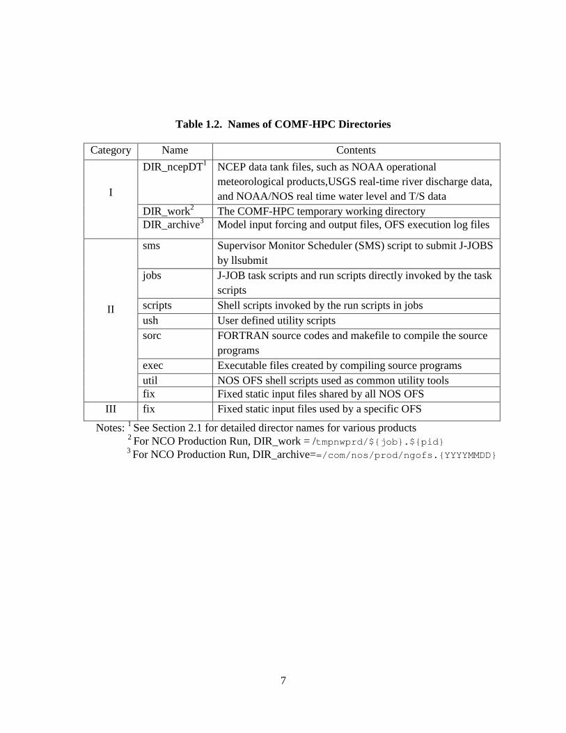
Table 1.2. Names of COMF-HPC Directories
Category Name Contents
I
DIR_ncepDT1 NCEP data tank files, such as NOAA operational meteorological products,USGS real-time river discharge data, and NOAA/NOS real time water level and T/S data
DIR_work2 The COMF-HPC temporary working directory DIR_archive3 Model input forcing and output files, OFS execution log files
II
sms Supervisor Monitor Scheduler (SMS) script to submit J-JOBS by llsubmit
jobs J-JOB task scripts and run scripts directly invoked by the task scripts
scripts Shell scripts invoked by the run scripts in jobs ush User defined utility scripts sorc FORTRAN source codes and makefile to compile the source
programs exec Executable files created by compiling source programs util NOS OFS shell scripts used as common utility tools fix Fixed static input files shared by all NOS OFS
III fix Fixed static input files used by a specific OFS
Notes: 1 See Section 2.1 for detailed director names for various products 2 For NCO Production Run, DIR_work = /tmpnwprd/${job}.${pid}
3 For NCO Production Run, DIR_archive==/com/nos/prod/ngofs.{YYYYMMDD}
7

Figure 1.2. The COMF-HPC core directory hierarchy. The names listed in the thick-line boxes are those mandated by NCO.
nosofs_shared.v2.2.0
sms sorc scripts ush
fix
jobs exec
nos ofs create forcing met fvcom.
nos ofs create forcing obc.fd
nos ofs create forcing obc fvcom.fd
nos ofs create forcing river.fd
nos ofs read restart selfe.fd
nos ofs met file search.fd
nos ofs reformat roms ctl.fd
nos ofs utility.fd
nos ofs tidalprediction.fd
ngofs.v2.0.0
fix
nos ofs create forcing met.fd
nos ofs read restart fvcom.fd
nos ofs read restart.fd
nos ofs create forcing obc tides.fd
FVCOM3.1.6.fd
SELFE.fd
ROMS3.6.fd
exec
8

2. DATA DESCRIPTION A variety of types of meteorological and hydrological data sets are needed in order to conduct NOS OFS nowcast/forecast runs through the COMF-HPC. The data involved are from two sources in terms of data archive sites, namely, the NCEP data tank and those archived locally within the COMF-HPC. The former includes products from a few operational meteorological models and real time oceanographic and river discharge observations. The latter include static and climatological data sets compiled by the NOS model development team, which include the World Ocean Atlas (WOA) climatology from NODC, river daily mean discharges and water temperature at USGS gauges, and tidal harmonic constants (averages for 1983-2001 NTDE) from NOS’s National Water Level Observation Network (NWLON). The following provides details about these data sets.
2.1. NCEP Data Tank Files The operational numerical model products archived in the NCEP data tank include those from NCEP’s North American Mesoscale (NAM) model, Global Forecast System (GFS), Real-Time Mesoscale Analysis (RTMA), Rapid Update Cycle (RUC), the National Digital Forecast Database (NDFD), Real-Time Ocean Forecast System (RTOFS), Extra-Tropical Storm Surge Model (ETSS), Navy’s Global Hybrid Coordinate Ocean Model (HYCOM), and Navy Regional Coastal Ocean Model (R-NCOM). The NOS COMF-HPC system utilizes a subset of the entire suite of meteorological properties of each model product; Table 2.1 gives a list of the properties involved with the COMF-HPC.
The observational data include water levels from NOS NWLON stations, water temperature and salinity from the NOS PORTS® stations, and river discharges, surface water temperature and salinity from the USGS river stations.
The water level data serve to adjust ETSS subtidal water level predictions (Section 4.2.5). The PORTS® station T/S data are used to adjust modeled water temperature and salinity open boundary conditions derived from either NCOM or WOA05. The river input data include river freshwater discharge, water temperature and salinity.
Table 2.2 lists the time line of the data availability for each nowcast/forecast cycle. It is noted that sometimes the data are unavailable at the time when needed by NOS OFS due to various system problems. When this occurs, climatological data (Section 2.2) archived within the COMF-HPC are then called and processed to feed the models.
The following lists the filenames and their locations on the NCEP WCOSS. Tables 2.1 and 2.2 list the parameters in each type of product and the timelines of their availability. In the file names, yyyy, mm, dd, are the year, the month, and the date of the nowcast/forecast run, cc is the cycle of the run, and hr is the forecast hour of the that cycle.
(1) NAM: /com/nam/prod/nam.{yyyymmdd}/nam.t{cc}z.awip12{hr}.tm00.grib2
(2) NAM4 (nested 4 km NAM): /com/nam/prod/nam.{yyyymmdd}/nam.t{cc}z.conusnest.hiresf{hr}.tm00.grib2[_nos]
9

(3) GFS: /com/gfs/prod/gfs.{yyyymmdd}/gfs.t{cc}z.pgrb2Ffh
(4) RTMA:
/com/rtma/prod/rtma.{yyyymmdd}/rtma.t{cc}z.2dvaranl_ndfd.grb2 (5) RUC:
/com/ruc/prod/ruc2a.{yyyymmdd}/ruc2.t{cc}z.bgrb13anl.grib2 (6) ETSS:
/com/gfs/prod/gfs.{yyyymmdd}/mdlsurgegrid.{cc}con
(6) NCOM/HYCOM: /dcom/us007003/{yyyymmdd}/wgrdbul/navy_hycom/hycom_glb_regp{01:06:07:17}_{yyyymmddhh}_t{FH}.nc.gz FH=000,003,…, 168
(7) G-RTOFS: /com/rtofs/prod/rtofs.{yyyymmdd}/rtofs_glo_3dz_f{FHH}_6hrly_hvr_reg[1:2:3].nc /com/rtofs/prod/rtofs.{yyyymmdd}/rtofs_glo_2ds_f{FHH}_3hrly_diag.nc
FHH=003,006,… (8) NOS PORTS hourly data:
/dcom/us007003/{yyyymmdd}/b001/xx005 6-minute data /dcom/us007003/{yyyymmdd}/b001/xx012
(9) USGS River data: /dcom /us007003/{yyyymmdd}/b001/xx009
Table 2.1. Parameters and data formats of various meteorological products.
Product Name Properties Data format
NAM Uwind, Vwind, Pair, Tair, Qair, Rsw, Rlw,down Grib2 GFS Uwind, Vwind, Pair, Tair, Qair, Rsw, Rlw,down Grib2
RTMA Uwind, Vwind, Pair, Tair, Qair, Grib2 RUC Uwind, Vwind, Pair, Tair, Qair, Rsw, Rlw Grib2 ETSS Subtidal water levels Grib2
HYCOM Water temperature and salinity NetCDF G-RTOFS Water temperature and salinity NetCDF
NOS water level Water level time series BUFR USGS River
discharge River discharge, water temperature and
salinity time series BUFR
10

Table 2.2. Timeline in UTC of the availability of the NCEP data tank products
Product Name Nowcast/Forecast Cycles 00 06 12 18
Maximum delay time
(hours) NAM 1:37 7:37 13:37 19:37 1:37 GFS 3:21 9:21 15:21 21:22 3:21
RTMA 0:38 6:38 12:38 18:38 :38 RUC 0:32 6:32 12:32 18:32 0:32 ETSS 3:57 9:58 15:57 21:58 3:58
NCOM 15:11 n/a n/a n/a 15:11 NDFD 0:06 6:06 12:08 18:05 0:08
GRTOFS 15:00 (20:55)
n/a (n/a)
n/a (n/a)
n/a (n/a)
15:00 (10:46)
NOS water level n/a1 n/a1 n/a1 n/a1 2:022 USGS river discharge n/a1 n/a1 n/a1 n/a1 Hourly
Update
Notes: 1 These are continuous data flows. The concept of nowcast/forecast cycles does not apply. 2 Real-time observations in CCS data tank are updated hourly.
2.2. Shared Static Dataset Some static data files (i.e., they do not change with time) are prepared and archived locally within COMF-HPC (nosofs_shared.v2.2.0/fix). These files include (1) nos.ofs.HC_NWLON.nc, which contains tidal elevation harmonic constants at NWLON stations; (2) nos.ofs.clim.WOA05.nc, which contains global climatological temperature and salinity of the WOA; (3) nos.ofs.river.clim.usgs.nc, which contains daily climatological river discharges, surface water temperature and salinity at USGS stations used by all existing NOS OFS. The above three files are shared by all NOS OFS.
2.3. Static Dataset for specific OFS There are static data files required by each individual OFS and these files for a specific OFS are saved in a separate directory for each OFS. The static file number and file format may be different for different OFS because each OFS may use a different hydrodynamic model and has different configurations. For ngofs, the directory name is, ngofs.v2.0.0/fix (with version number), which contains the following files,
nos.ngofs.ctl – main control file for ngofs nos.ngofs.HC.nc – harmonic constants of elevations and currents at all open boundary model
grids. nos.ngofs.fvcom.nml – template file of FVCOM runtime control file nos.ngofs.grid.dat – ngofs model grid file nos.ngofs.init.nc – static ngofs initial file for a coldstart simulation
11

nos.ngofs.obc.ctl – ngofs open boundary control file nos.ngofs.river.ctl – ngofs river control file for generating river forcing file for nowcast/forecast
simulation. nos.ngofs.vgrid.dat – ngofs vertical coordinate setup file nos.ngofs_cor.dat – reference to FVCOM User Manual nos.ngofs_dep.dat – reference to FVCOM User Manual nos.ngofs_grd.dat – reference to FVCOM User Manual nos.ngofs_obc.dat – reference to FVCOM User Manual nos.ngofs_rivernamelist.nml – runtime control file for river inputs nos.ngofs_sigma.dat – reference to FVCOM User Manual nos.ngofs_spg.dat – reference to FVCOM User Manual nos.ngofs_station.dat – station time series control file for point/station output
12

3. OFS CONTROL FILES The primary objective of COMF-HPC is to allow a multiplicity of forecast systems to be operated and maintained in an efficient and robust manner, and to ensure a high time-and-cost efficiency for OFS development, transition, and operational maintenance. To reach this goal, most of the important parameters for an operational forecast system configuration are specified in a main control file called “nos.${OFS}.ctl. Two other important control files are for generating the open boundary forcing file (nos.${OFS}.obc.ctl) and generating the river forcing file (nos.${OFS}.obc.ctl). In most cases, an OFS configuration can be easily modified without changes of scripts and FORTRAN codes. The main control file, nos.${OFS}.ctl is called in the scripts of “exnos_ofs_prep.sh.ecf” and “exnos_ofs_nowcast_forecast.sh.ecf”. The open boundary control file, nos.${OFS}.obc.ctl is used in the FORTRAN Programs for generating the open boundary forcing file, such as “nos_ofs_create_forcing_obc.f”, “nos_ofs_create_forcing_obc_fvcom.f”, and “nos_ofs_create_forcing_obc_selfe.f”. This section describes the three control files in more detail.
3.1. Main Control File For each OFS, there is a main control file called “nos.${OFS}.ctl” which is saved in /nwprod/ngofs.v2.0.0/fix. The parameters contained in this main control file may not be exactly the same for different NOS OFS, but the following parameters are normally included in this control file, export DBASE_MET_NOW=NAM4 export DBASE_MET_FOR=NAM4 export DBASE_WL_NOW=RTOFS export DBASE_WL_FOR=RTOFS export DBASE_TS_NOW=RTOFS export DBASE_TS_FOR=RTOFS export OCEAN_MODEL=FVCOM export LEN_FORECAST=48 export IGRD_MET=1 export IGRD_OBC=1 export BASE_DATE=1858111700 export TIME_START=2009092406 export MINLON=-99.0 export MINLAT=25.0 export MAXLON=-82.0 export MAXLAT=32.0 export THETA_S=4.5d0 export THETA_B=0.95d0 export TCLINE=10.0d0 export SCALE_HFLUX=1.0 export CREATE_TIDEFORCING=0 ######################################################## ## static input file name, do not include path name ######################################################## export GRIDFILE=nos.ngofs.grid.dat export HC_FILE_OBC=nos.ngofs.HC.nc
13

export HC_FILE_OFS=nos.ngofs.HC.nc export RIVER_CTL_FILE=nos.ngofs.river.ctl export RIVER_CLIM_FILE=nos.ofs.river.clim.usgs.nc export OBC_CTL_FILE=nos.ngofs.obc.ctl export OBC_CLIM_FILE=nos.ofs.clim.WOA05.nc export STA_OUT_CTL=nos.ngofs_station.dat export VGRID_CTL=nos.ngofs.vgrid.dat export RUNTIME_CTL=nos.ngofs.fvcom.nml export HC_FILE_NWLON=nos.ofs.HC_NWLON.nc export OBC_FILE_TEMPLATE=nos.ngofs.obc.template.nc ######################################################## # parameters for FVCOM RUN ######################################################## export NNODE=90267 export NELE=174474 export KBm=40 export DELT_MODEL=12 export EXTSTEP_SECONDS=12.0 export ISPLIT=3 export RST_OUT_INTERVAL=21600.0 export NSTA=360.0 export IREPORT=100 export NFLT=3600.0 export NC_OUT_INTERVAL=3600.0 export NC_STA_INTERVAL=360.0 export NAVG=3600 export NRIVERS=44 export N_PROC=6 export TOTAL_TASKS=192 export NTILE_I=12 export NTILE_J=16 export MIN_DEPTH=0.5 export HEATING_LONGWAVE_LENGTHSCALE=6.3 export HEATING_LONGWAVE_PERCTAGE=0.78 export HEATING_SHORTWAVE_LENGTHSCALE=1.4 export NESTING_BLOCKSIZE=5 ### Files Used in Model Run export RIVER_NAMELIST=nos.ngofs.RIVERS_NAMELIST.nml export CORIOLISFILE=nos.ngofs.cor.dat export DEPTHFILE=nos.ngofs.dep.dat export RUNGRIDFILE=nos.ngofs.grd.dat export MODELOBCFILE=nos.ngofs.obc.dat export SIGMA_LEVEL=nos.ngofs.sigma.dat export SPONGEFILE=nos.ngofs.spg.dat export STATIONFILE=nos.ngofs.station.dat export InputNodeFile=nos.ngofs.node.dat export InputNode2LFile=nos.ngofs.node.2LayerNd.dat # Parameters Used in Model RUN export NRST=3600 export NSTA=360 export NFLT=3600
14

export NHIS=3600 export NAVG=3600 export DCRIT="0.10d0 !m" export N_PROC=4 export TOTAL_TASKS=128 DBASE_MET_NOW Data source Name of NCEP atmospheric operational products
for Nowcast run. e.g. NAM, GFS, RTMA, NDFD, etc. DBASE_MET_FOR Data source Name of NCEP atmospheric operational products
for Forecast run. e.g. NAM, GFS, RTMA, NDFD, etc. DBASE_WL_NOW Data source Name of subtidal water level open boundary
conditions for Nowcast run, e.g. NCOM, ETSS DBASE_WL_FOR Data source Name of water level open boundary conditions
for Forecast run. DBASE_TS_NOW Data source Name of T & S open boundary conditions for
Nowcast run, e.g. NCOM, World Ocean Atlas (WOA) DBASE_TS_FOR Data source Name of T & S open boundary conditions for
Forecast run. OCEAN_MODEL Name of Hydrodynamic Ocean Model, e.g. ROMS, FVCOM, SELFE LEN_FORECAST Hours of Forecast length of one OFS forecast cycle. IGRD_MET: spatial interpolation method for atmospheric forcing fields =0: on native grid of NCEP products with wind rotated to earth
coordinates =1: on ocean model grid (rotated to local coordinates)
interpolated using remesh routine. =2: on ocean model grid (rotated to local coordinates)
interpolated using bicubic routine. =3: on ocean model grid (rotated to local coordinates)
interpolated using bilinear routine. =4: on ocean model grid (rotated to local coordinates)
interpolated using nature neighbors routine. IGRD_OBC spatial interpolation method for ocean open boundary
forcing fields, see IGRD_MET BASE_DATE base date for the OFS time system, The time is reference to
this BASE_DATE. e.g. YYYYMMDDHH (2008010100) TIME_START This parameter is used only for ROMS model. OFS simulation
start time/current time, e.g. 2008110600 MINLON longitude of lower left/southwest corner to cover the OFS
domain MINLAT latitude of lower left /southwest corner to cover the OFS
domain MAXLON longitude of upper right/northeast corner to cover the OFS
domain MAXLAT latitude of upper right/northeast corner to cover the OFS
domain THETA_S S-coordinate surface control parameter, [0 < theta_s < 20].
This parameter is used only in the case of OCEAN_MODEL=ROMS THETA_B S-coordinate bottom control parameter, [0 < theta_b < 1].
This parameter is used only in the case of OCEAN_MODEL=ROMS TCLINE Width (m) of surface or bottom boundary layer in which higher vertical resolution is required during stretching.
This parameter is used only in the case of OCEAN_MODEL=ROMS
15

SCALE_HFLUX Scaling factor (fraction) of surface heat flux (net short-
wave and downward long-wave radiation) of original atmospheric products. If SCALE_HFLUX=1.0, no adjustment to atmospheric products; SCALE_HFLUX > 1.0, increasing heat flux of the original products; SCALE_HFLUX < 1.0, reducing the heat flux of the original products.
CREATE_TIDEFORCING If CREATE_TIDEFORCING > 0, generate new ROMS tidal forcing file; if CREATE_TIDEFORCING < 0, do not generate new ROMS tidal forcing file, instead the existing ROMS tidal forcing file is used.
GRIDFILE model grid file HC_FILE_OBC This NetCDF file contains all harmonic constants required
to generate open boundary conditions. The harmonic constants can be derived from ADCIRC EC2001 harmonic constant file in Gulf of Mexico and East Coast regions.
HC_FILE_OFS This NetCDF file contains all harmonic constants used to directly force ROMS model (ROMS Tidal forcing file containing tide constituents of WL, ubar, and vbar), or used to generate open boundary forcing file for FVCOM and SELFE models. For ROMS model, it can be generated from HC_FILE_OBC if CREATE_TIDEFORCING > 0.
RIVER_CTL_FILE River control file used to generate river forcing file RIVER_CLIM_FILE This NetCDF file contains climatological river dataset at
USGS river gauges used by all NOS OFS. The dataset are daily mean of river discharges, water temperature, and salinity.
OBC_CTL_FILE: Control file used to generate open boundary conditions OBC_CLIM_FILE This NetCDF file contains climatological temperature and
salinity from the World Ocean Atlas produced by National Ocean Data Center (NODC).
STA_OUT_CTL Control file for OFS station outputs. RUNTIME_CTL A template file of runtime control file of the ocean model,
which contains all parameters used to run the hydrodynamic model.
HC_FILE_NWLON This NetCDF file contains all water level harmonic constants at all NOS NWLON stations. It is used to generate open boundary forcing file.
VGRID_CTL This file contains parameters to set up vertical coordinates for NOS OFS.
IM GRID Number of I-direction RHO-points, it is xi_rho for ROMS
JM GRID Number of J-direction RHO-points, it is eta_rho for ROMS
NNODE Total node number of unstructured model grid NELE Total element number of unstructured model grid DELT_MODEL Time-Step size in seconds. If 3D configuration, DT is the size of baroclinic time-step. If only 2D configuration, DT is the size of the barotropic time-step. NDTFAST/ISPLIT Number of barotropic time-steps between each baroclinic
time step. If only 2D configuration, NDTFAST should be unity since there is not a need to splitting time-stepping.
KBm Number of vertical levels at temperature points of OFS NRST Number of time-steps between writing of re-start fields.
16

NSTA Number of time-steps between writing data into stations file. Station data is written at all levels.
NFLT Number of time-steps between writing data into floats file. NHIS Number of time-steps between writing fields into history
file. RDRG2 Quadratic bottom drag coefficient. Zob Bottom roughness (m). AKT_BAK Background vertical mixing coefficient (m2/s) for active (NAT) and inert (NPT) tracer variables. AKV_BAK Background vertical mixing coefficient (m2/s) for momentum. AKK_BAK Background vertical mixing coefficient (m2/s) for turbulent kinetic energy. AKP_BAK Background vertical mixing coefficient (m2/s) for turbulent generic statistical field, "psi". TKENU2 Lateral, harmonic, constant, mixing coefficient (m2/s) for turbulent closure variables. TKENU4 Lateral, biharmonic, constant mixing coefficient (m4/s) for turbulent closure variables. DCRIT Minimum depth (m) for wetting and drying. DSTART Time stamp assigned to model initialization (days).
Usually a Calendar linear coordinate, like modified Julian Day.
TIDE_START Reference time origin for tidal forcing (days). This is the time used when processing input tidal model data. It is
needed in routine "set_tides" to compute the correct phase lag with respect ROMS/TOMS initialization time.
N_PROC Number of computer processors to run parallel ocean model TOTAL_TASKS Total tasks to be run NTILE_I Number of domain partitions in the I-direction (XI-
coordinate). It must be equal or greater than one. NTILE_J Number of domain partitions in the J-direction (ETA-
coordinate).It must be equal or greater than one.
3.2. Control File for Open Boundary Condition Generation For each OFS, a control file is required for generating lateral open boundary conditions. A standard format is used for all OFS, and details are given in the control file. The following is the control file for NGOFS. Section 1 includes information about USGS or NOS gauges where real-time observations are available; Section 2 includes information of model lateral open boundary grid cells to specify open boundary conditions; and Section 3 is currently used for the OFS which uses the FVCOM. 5 338 336 1.0 :NSTA NOBC NEL_OBC DELT SECTION 1: WATER LEVEL and WATER TEMPERATURE INFORMATION FOR LATERAL OPEN BOUNDARY SID NOS_ID NWS_ID AGENCY_ID DATUM FLAG TS_FLAG BACKUP_SID GRIDID_STA AS GAUGENAME 1 8779748 PCGT2 NOAA 0.237 0 0 3 1 1.0 S Padre Island 2 8729108 PACF1 NOAA 0.203 0 1 4 170 1.0 Panama City 3 8779770 PTIT2 NOAA 0.247 1 1 5 1 1.0 Port Isabel 4 8729840 PCLF1 NOAA 0.188 1 1 0 170 1.0 Pensacola 5 4204499 42044 NOAA -9999. 1 1 0 1 1.0 TABS J SECTION 2: CONFIGURATION OF LATERAL OPEN BOUNDARY
17

GRIDID NODE_ID WL_STA WL_SID_1 WL_S_1 WL_SID_2 WL_S_2 TS_STA TS_SID_1 TS_S_1 TS_SID_2 TS_S_2 1 1 1 1 1.00 0 0.00 1 3 1.00 0 0.00 2 2 1 1 1.00 0 0.00 1 3 0.95 0 0.00 3 3 1 1 0.99 0 0.00 1 3 0.90 0 0.00 4 4 1 1 0.99 0 0.00 1 3 0.85 0 0.00 5 5 1 1 0.99 0 0.00 1 3 0.80 0 0.00 6 6 1 1 0.98 0 0.00 1 3 0.75 0 0.00 . . . 338 338 1 2 0.99 0 0.00 1 2 1.00 0 0.00 SECTION 3: CONFIGURATION OF LATERAL OPEN BOUNDARY SeqNumber ElementID CU_STA CU_1 CU_2 1 250 0 0 0 2 251 0 0 0 3 252 0 0 0 4 253 0 0 0 . . . 336 161 0 0 0 ------------------------------------------------------------------------------------------------- GLOSSARY: NSTA Total number of observation/climatology stations NOBC Total number of ocean model open boundary grid points DELT Time interval of final open boundary condition time series SECTION 1 NWLON TIDE GAUGE INFORMATION SID sequential number of observational station NOS_ID NOS NWLON/PORTS tide gauge ID (NWLON, BUOY, CMAN, USGS,etc.) NWS_ID NWS SHEF ID which is used to extract real time data from NWS BUFR files AGENCY_ID Agency who provides observation for this station DATUM Datum to convert water level from MLLW to MSL FLAG indicator
of it is a primary or backup station,=0, used as a primary station for WL OBC correction using real time observations=1, used as a backup station for WL OBC correction using real time observations
TS_FLAG indicator of whether it is used for T/S boundary condition, =0, no T/S data are used; =1, real time T/S obs are used to specify T/S open boundary
conditions; climatology is automatically used if no real time is available;
=2, use static historical data set to specify T/S open boundary conditions. If TS_FLAG > 0, T/S climatology have to be specified.
BACKUP_SID SID of backup station for this station. The real time obs at BACKUP_SID is used to this station. If BACKUP_SID <=0, there is no backup for this station. For instance for DBOFS, Atlantic City's backup station is Cape May (BACKUP_SID=4)
GRIDID_STA GRIDID of open boundary grid point in Section 2 which the observation gauge corresponds to. From GRIDID_STA, IROMS and JROMS can be found in Section 2, GRIDID_STA <= 0 means the station is out of model domain. For a primary station, GRIDID_STA must be a GRIDID listed in Section 2. For a backup station, GRIDID_STA can be same as its primary station, and
18
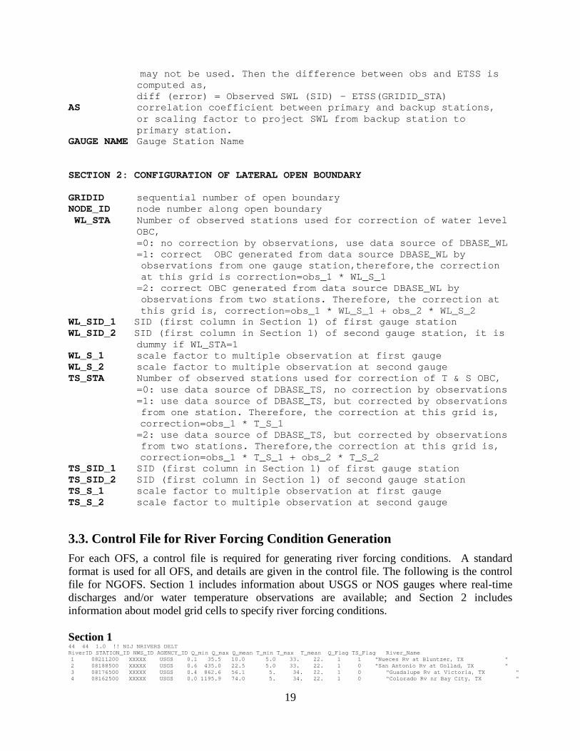
may not be used. Then the difference between obs and ETSS is computed as,
diff (error) = Observed SWL (SID) - ETSS(GRIDID_STA) AS correlation coefficient between primary and backup stations,
or scaling factor to project SWL from backup station to primary station.
GAUGE NAME Gauge Station Name SECTION 2: CONFIGURATION OF LATERAL OPEN BOUNDARY GRIDID sequential number of open boundary NODE_ID node number along open boundary WL_STA Number of observed stations used for correction of water level
OBC, =0: no correction by observations, use data source of DBASE_WL =1: correct OBC generated from data source DBASE_WL by
observations from one gauge station,therefore,the correction at this grid is correction=obs_1 * WL_S_1
=2: correct OBC generated from data source DBASE_WL by observations from two stations. Therefore, the correction at this grid is, correction=obs_1 * WL_S_1 + obs_2 * WL_S_2
WL_SID_1 SID (first column in Section 1) of first gauge station WL_SID_2 SID (first column in Section 1) of second gauge station, it is
dummy if WL_STA=1 WL_S_1 scale factor to multiple observation at first gauge WL_S_2 scale factor to multiple observation at second gauge TS_STA Number of observed stations used for correction of T & S OBC, =0: use data source of DBASE_TS, no correction by observations =1: use data source of DBASE_TS, but corrected by observations
from one station. Therefore, the correction at this grid is, correction=obs_1 * T_S_1 =2: use data source of DBASE_TS, but corrected by observations
from two stations. Therefore,the correction at this grid is, correction=obs_1 * T_S_1 + obs_2 * T_S_2 TS_SID_1 SID (first column in Section 1) of first gauge station TS_SID_2 SID (first column in Section 1) of second gauge station TS_S_1 scale factor to multiple observation at first gauge TS_S_2 scale factor to multiple observation at second gauge
3.3. Control File for River Forcing Condition Generation For each OFS, a control file is required for generating river forcing conditions. A standard format is used for all OFS, and details are given in the control file. The following is the control file for NGOFS. Section 1 includes information about USGS or NOS gauges where real-time discharges and/or water temperature observations are available; and Section 2 includes information about model grid cells to specify river forcing conditions. Section 1 44 44 1.0 !! NIJ NRIVERS DELT RiverID STATION_ID NWS_ID AGENCY_ID Q_min Q_max Q_mean T_min T_max T_mean Q_Flag TS_Flag River_Name
1 08211200 XXXXX USGS 0.1 35.5 10.0 5.0 33. 22. 1 1 "Nueces Rv at Bluntzer, TX " 2 08188500 XXXXX USGS 0.6 435.0 22.5 5.0 33. 22. 1 0 "San Antonio Rv at Gollad, TX " 3 08176500 XXXXX USGS 0.4 862.6 56.1 5. 34. 22. 1 0 "Guadalupe Rv at Victoria, TX " 4 08162500 XXXXX USGS 0.0 1195.9 74.0 5. 34. 22. 1 0 "Colorado Rv nr Bay City, TX "
19

5 08116650 XXXXX USGS 0.8 1999.6 237.7 5. 34. 22. 1 0 "Brazos Rv nr Rosharon, TX " 6 08073700 XXXXX USGS 0.2 51.1 10.5 5. 34. 22. 1 0 "Buffalo B ayou at Piney Point, TX " 7 08068000 XXXXX USGS 0.3 221.1 15.3 5. 33. 22. 1 1 "W Fk San Jacinto Rv nr Conroe, TX " 8 08066500 XXXXX USGS 2.9 1862.1 224.1 5. 34. 22. 1 0 "Trinity Rv at Romayor, TX " 9 08030500 XXXXX USGS 7.9 1366.8 224.3 5. 34. 22. 1 0 "Village, Neches, Sabine Rvs, TX " 10 08015500 XXXXX USGS 3.6 1031.2 73.5 5. 34. 22. 1 0 "Calcasieu Rv nr Kinder, LA " 11 08012000 XXXXX USGS 0.1 260.8 23.5 5. 34. 22. 1 0 "Nezpique nr Basile, LA " 12 07385765 XXXXX USGS 0.2 56.6 11.3 5. 34. 22. 1 0 "Bayou Teche nr Jeanerette, LA " 13 07381490 XXXXX USGS 1983. 9600. 8501. 5. 34. 22. 1 0 "Atchafalaya Rv at Simmesport, LA " 14 07374000 XXXXX USGS 4250. 28388. 13347. 5. 32. 21. 1 1 "Mississippi Rv at Baton Rouge, LA " 15 07375500 XXXXX USGS 6.6 249.7 32.5 5. 34. 22. 1 0 "Tangipahoa Rv at Robert, LA " 16 02492000 XXXXX USGS 10.5 414.9 56.5 5. 34. 22. 1 0 "Bogue Chitto Rv nr Bush, LA " 17 02489500 XXXXX USGS 29.2 1906.9 281.9 5. 34. 22. 1 0 "Pearl Rv nr Bogalusa, LA " 18 02481510 XXXXX USGS 0.4 85.2 17.2 5. 34. 22. 1 0 "Wolf Rv Nr Landon, MS " 19 02479000 XXXXX USGS 1.8 368.6 35.5 5. 34. 22. 1 0 "rscagoula Rv at Merrill, MS " 20 02470629 XXXXX USGS 10.0 1653.0 700.5 5. 34. 22. 1 0 "Mobile Rv at Bucks, AL " 21 02471019 XXXXX USGS 10.0 1584.4 619.2 5. 34. 22. 1 0 "Tensaw Rv nr Mount Vernon, AL " 22 02376500 XXXXX USGS 4.8 90.1 22.2 5. 34. 22. 1 0 "Perdido Rv at Barrineay Park, FL " 23 02375500 XXXXX USGS 12.8 930.6 166.0 5. 34. 22. 1 0 "Escambia Rv nr Century, FL " 24 02368000 XXXXX USGS 3.5 186.4 32.8 5. 34. 22. 1 0 "Yellow Rv at Mill, Shoal Rv, FL " 25 02365500 XXXXX USGS 14.3 827.2 153.5 5. 34. 22. 1 0 "Choctawahathee Rv at Caryville, FL " 26 08067100 XXXXX USGS -9999. 9999. 9999. 5.0 34.0 22.1 3 1 "Trinity Rv nr Moss Bluff, TX " 27 08041770 XXXXX USGS -9999. 9999. 9999. 5.0 33.0 22.0 3 1 "LNVA Canal at Beaumont, TX " 28 08017044 XXXXX USGS -9999. 9999. 9999. 5.0 33.0 22.2 3 1 "Calcasieu Rv I-10 at Lk Charles, LA " 29 073814675 XXXXX USGS -9999. 9999. 9999. 5.0 33.0 22.1 3 1 "Bayou Boeuf at Amelia, LA " 30 073815963 XXXXX USGS -9999. 9999. 9999. 6.0 33.0 22.5 3 1 "Murphy Lake near Bayou Sorrel, LA " 31 02492100 XXXXX USGS -9999. 9999. 9999. 5.0 33.0 22.5 3 1 "Pearl Rv Navag Canal Dam No. 2 LA " 32 02492519 XXXXX USGS -9999. 9999. 9999. 5.0 33.0 22.5 3 1 "Pearl Rv Navag Canal Dam No. 1 LA " 33 02481660 XXXXX USGS -9999. 9999. 9999. 5.0 33.0 22.5 3 1 "Ourdan Rv nr Bay St Louis, MS " 34 02479130 XXXXX USGS -9999. 9999. 9999. 5.0 33.0 22.5 3 1 "Black Ck nr Brooklyn, MS " 35 301001089442600 XXXXX USGS -9999. 9999. 9999. 5.0 33.0 22.5 3 1 "Rigolets at Hwy 90 Nr Slidell, LA " 36 301141089320300 XXXXX USGS -9999. 9999. 9999. 5.0 33.0 22.5 3 1 "East Peral Rv at CSX nr Claiborne, MS" 37 8773037 SDRT2 COOPS -9999. 9999. 9999. 5.0 34.0 22.5 3 1 "Seadrift, Tx " 38 8773259 XXXXX COOPS -9999. 9999. 9999. 5.0 34.0 22.5 3 1 "Port Lavaca, TX " 39 8772447 FCGT2 COOPS -9999. 9999. 9999. 5.0 34.0 22.5 3 1 "USCG Freeport, TX " 40 8770570 SBPT2 COOPS -9999. 9999. 9999. 5.0 34.0 22.5 3 1 "Sabine Path North, TX " 41 8761305 SHBL1 COOPS -9999. 9999. 9999. 5.0 34.0 22.5 3 1 "Shell Beach, LA " 42 8747437 WYCM6 COOPS -9999. 9999. 9999. 5.0 34.0 22.5 3 1 "Bay Waveland Yacht Club, MS " 43 8737048 OBLA1 COOPS -9999. 9999. 9999. 5.0 34.0 22.5 3 1 "Mobile State Docks, AL " 44 8729840 PCLF1 COOPS -9999. 9999. 9999. 5.0 34.0 22.5 3 1 "Pensacola, FL "
Section 2: Information about FVCOM grids/locations to specify river inputs GRID_ID NODE_ID ELE_ID DIR FLAG RiverID_Q Q_Scale RiverID_T T_Scale River_Basin_Name 1 24153 1 0 3 1 1.0 1 1.0 "Nueces Rv at Bluntzer, TX " 2 23097 2 0 3 2 1.0 37 1.0 "San Antonio Rv at Gollad, TX " 3 23098 3 0 3 3 1.0 37 1.0 "Guadalupe Rv at Victoria, TX " 4 32482 4 0 3 4 1.0 38 1.0 "Colorado Rv nr Bay City, TX " 5 38798 5 0 3 5 1.0 39 1.0 "Brazos Rv nr Rosharon, TX " 6 89538 6 0 3 6 2.0 7 1.0 "Buffalo B ayou at Piney Point, TX " 7 89664 7 0 3 7 4.0 7 1.0 "W Fk San Jacinto Rv nr Conroe, TX " 8 88931 8 0 3 8 1.0 26 1.0 "Trinity Rv at Romayor, TX " 9 61006 9 0 3 9 2.2 27 1.0 "Village, Neches, Sabine Rvs, TX " 10 64011 10 0 3 10 1.0 28 1.0 "Calcasieu Rv nr Kinder, LA " 11 64019 11 0 3 11 1.0 28 1.0 "Nezpique nr Basile, LA " 12 67480 12 0 3 12 1.0 29 1.0 "Bayou Teche nr Jeanerette, LA " 13 79585 13 0 3 13 0.33 14 1.0 "Atchafalaya Rv at Simmesport, LA " 14 79586 14 0 3 13 0.34 14 1.0 "Atchafalaya Rv at Simmesport, LA " 15 79587 15 0 3 13 0.34 14 1.0 "Atchafalaya Rv at Simmesport, LA " 16 62740 16 0 3 14 0.040 14 1.0 "Mississippi Rv at Baton Rouge, LA " 17 53084 17 0 3 14 0.034 14 1.0 "Mississippi Rv at Baton Rouge, LA " 18 52236 18 0 3 14 0.034 14 1.0 "Mississippi Rv at Baton Rouge, LA " 19 52235 19 0 3 14 0.035 14 1.0 "Mississippi Rv at Baton Rouge, LA " 20 27893 20 0 3 14 0.099 14 1.0 "Mississippi Rv at Baton Rouge, LA " 21 27892 21 0 3 14 0.099 14 1.0 "Mississippi Rv at Baton Rouge, LA " 22 26886 22 0 3 14 0.099 14 1.0 "Mississippi Rv at Baton Rouge, LA " 23 23744 23 0 3 14 0.010 14 1.0 "Mississippi Rv at Baton Rouge, LA " 24 22631 24 0 3 14 0.010 14 1.0 "Mississippi Rv at Baton Rouge, LA " 25 20378 25 0 3 14 0.049 14 1.0 "Mississippi Rv at Baton Rouge, LA " 26 21497 26 0 3 14 0.049 14 1.0 "Mississippi Rv at Baton Rouge, LA " 27 20383 27 0 3 14 0.050 14 1.0 "Mississippi Rv at Baton Rouge, LA " 28 14115 28 0 3 14 0.074 14 1.0 "Mississippi Rv at Baton Rouge, LA " 29 14116 29 0 3 14 0.074 14 1.0 "Mississippi Rv at Baton Rouge, LA " 30 14117 30 0 3 14 0.074 14 1.0 "Mississippi Rv at Baton Rouge, LA " 31 14118 31 0 3 14 0.075 14 1.0 "Mississippi Rv at Baton Rouge, LA " 32 32096 32 0 3 14 0.048 14 1.0 "Mississippi Rv at Baton Rouge, LA " 33 32097 33 0 3 14 0.047 14 1.0 "Mississippi Rv at Baton Rouge, LA " 34 88869 34 0 3 15 1.0 35 1.0 "Tangipahoa Rv at Robert, LA " 35 88169 35 0 3 16 1.0 31 1.0 "Bogue Chitto Rv nr Bush, LA " 36 88090 36 0 3 17 1.0 31 1.0 "Pearl Rv nr Bogalusa, LA " 37 85595 37 0 3 18 1.0 33 1.0 "Wolf Rv Nr Landon, MS " 38 70887 38 0 3 19 1.1 34 1.0 "Black Ck, Red Ck, Pasc Rv at Merr, MS" 39 86790 39 0 3 20 1.0 43 1.0 "Mobile Rv at Bucks, AL " 40 87516 40 0 3 21 1.0 43 1.0 "Tensaw Rv nr Mount Vernon, AL " 41 40692 41 0 3 22 1.0 44 1.0 "Perdido Rv at Barrineay Park, FL " 42 76267 42 0 3 23 1.0 44 1.0 "Escambia Rv nr Century, FL " 43 50759 43 0 3 24 1.8 44 1.0 “Yellow Rv at Mill, Shoal Rv, FL " 44 75834 44 0 3 25 1.0 44 1.0 "Choctawahathee Rv at Caryville, FL "
-----------------------------------------------------------------------------------------------------
20

GLOSSARY: NIJ Number of model grids to specify river discharges NRIVERS Number of USGS river observing stations DELT Time interval in hours for output time series. RiverID Serial Identification number of USGS River STATION_ID River Identification number NWS_ID NWS Identification number for USGS river AGENCY Station owner agency name GRID_NODE Serial Identification number for model grid location to specify river input FLAG River runoff trace flag, 0: all tracers (T & S) are off; 1: only T is on; 2: only
S is on; 3: both T and S are on. RiverID_Q RiverID in Section 1 which is used to specify river discharge at the
corresponding model grid RiverID_T RiverID in Section 1 which is used to specify river temperature at the
corresponding model grid Q_Scale scaling factor of river discharge at the model grid T_scale scaling factor of river temperature at corresponding model grid. Q_min minimum discharge value of the river Q_mean average discharge value of the river Q_max maximum discharge value of the river T_min minimum discharge value of the temperature T_mean average discharge value of the temperature T_max maximum discharge value of the temperature Q_Flag =0: use climatological river discharges data (daily mean); =1: use real-time river discharge observations.
=2: use stage height, have to provide to use the provided rating tables to convert stage height into discharge
>=3 discharge at the river is not used, river is for T and Salinity TS_Flag =0: use climatological temperature data (daily mean); =1: use real-time river temperature observations. River_Basin_Name Name of Rivers or river basins
21

22

4. SCRIPTS AND FORTRAN PROGRAMS Section 1.3 illustrates the structure of the COMF-HPC directory hierarchy. The scripts and FORTRAN programs which make up the COMF-HPC system are mostly found in the nosofs_shared.vX.X.X directory. Shell scripts are saved in the subdirectories of jobs, scripts, and ush. And all FORTRAN and C programs which perform specialized tasks are found in the subdirectory of sorc. The scripts and programs in each subdirectory of nosofs_shared.vX.X.X are explained and listed in the following sections.
4.1. Scripts Library 4.1.1. sms WCOSS uses ECFLOW to schedule and trigger jobs, and ECFLOW is not currently used for development. Therefore, the launch scripts used for Production Suite and development runs are different. There are concentrated on development side.
(1) jnos_ngofs_prep_00.sms This is the top level (first) scripts to launch prep jobs using command “llsubmit” like, Bsub < jnos_ngofs_prep_03.sms The following environment variables are setup before calling a J-JOB script of “JNOS_OFS_PREP.sms.dev”
export envir=prod export cyc=00 export OFS=ngofs export model_ver=v1.0.0 export code_ver=v1.0.0 Usage: Bsub < jnos_ngofs_prep_${cyc}.sms while cyc is cycle to run, i.e. 00, 06, 12, 18
(2) jnos_ngofs_nowcst_fcst_00.sms
This is the top level (first) scripts to launch jobs to conduct model nowcast and forecast simulations using command “llsubmit” like, Bsub < jnos_ngofs_nowcst_fcst_00.sms The following environment variables are setup before calling a J-JOB script of “JNOS_OFS_NOWCst_FCST.sms.dev” export envir=prod export cyc=00 export OFS=ngofs export model_ver=v1.0.0 export code_ver=v1.0.0
23

Usage:
Bsub < jnos_ngofs_nowcst_fcst_${cyc}.sms where cyc is cycle to run, i.e. 00, 06, 12, 18
4.1.2. jobs (1) JNOS_OFS_PREP:JNOS_OFS_PREP.sms.dev
This script implements the data preparation jobs for the OFS nowcast and forecast runs. It sets up and exports various environment variables (path names and file names) for the present cycle OFS job identification. For example, it identifies paths to the NCEP data tank for meteorological products and utility programs, and it also defines the names of the system report log and CORMS flag files. At the end, it launches a script program for preparing forcing data files for the OFS model runs.
Usage: JNOS_OFS_PREP.sms.dev
Input: Output:
nos.ngofs.jlogfile.{YYYYMMSS}.${cc}.log: system report file, nos.ngofs.corms.{YYYYMMDD}.${cc}.log: CORMSLOG file
Calls: scripts/exnos_ofs_prep.sh.sms ${OFS}
Called by: sms/jnos_ngofs_prep_00.sms (2) JNOS_OFS_NOWCST_FCST :JNOS_OFS_NOWCST_FCST.sms.dev:
This script implements the OFS nowcast and forecast runs. It sets up and exports various environment variables (path names and file names) to the present cycle OFS job identifications. For example, it specifies paths to the NCEP data tank for meteorological products and utility programs, and the names of the system report log and CORMS flag files. At the end, it launches the nos_ofs_launch.sh and nos_ofs_nowcst_fcst.sh.
Usage: JNOS_OFS_NOWCST_FCST.sms.dev Input: Output: nos.ngofs.jlogfile.{YYYYMMSS}.${cc}.log: system report file, nos.ngofs.corms.{YYYYMMDD}.${cc}.log: CORMSLOG file
24

Calls: scripts/exnos_ofs_nowcst_forecast.sh.sms ngofs Called by: sms/jnos_ngofs_nowcst_fcst_00.sms 4.1.3. scripts (1) exnos_ofs_prep.sh.sms
This script launches data preparation scripts before the OFS nowcast and forecast runs. All forcing files and model runtime control files are generated after executing this script. In addition, all OFS related parameters are setup by calling a static OFS control file (e.g. nos.ngofs.ctl).
Usage: exnos_ofs_prep.sh.sms ngofs
Input: ngofs.vX.X.X/fix/nos.ngofs.ctl Output:
nos.ngofs.met.nowcast.{YYYYMMDD}.t{cc}z.nc nos.ngofs.met.forecast.{YYYYMMDD}.t{cc}z.nc nos.ngofs.obc.{YYYYMMDD}.t{cc}z.nc nos.ngofs.river.{YYYYMMDD}.t{cc}z.nc nos.ngofs.hflux.nowcast.{YYYYMMDD}.t{cc}z.nc nos.ngofs.hflux.forecast.{YYYYMMDD}.t{cc}z.nc nos.ngofs.nowcast.{YYYYMMDD}.t{cc}z.in nos.ngofs.forecast.{YYYYMMDD}.t{cc}z.in nos.ngofs.jlogfile.{YYYYMMSS}.${cc}.log: system report file, nos.ngofs.corms.{YYYYMMDD}.${cc}.log: CORMSLOG file
Calls: ush/nos_ofs_launch.sh ush/nos_ofs_create_forcing_met.sh ush/nos_ofs_create_forcing_river.sh ush/nos_ofs_create_forcing_obc.sh ush/nos_ofs_prep_fvcom_ctl.sh ush/nos_ofs_prep_roms_ctl.sh
Called by: jobs/JNOS_OFS_PREP.sms.dev
(2) exnos_ofs_nowcst_forecast.sh.sms This script launches both nowcast and forecast simulations. After completing nowcast and forecast simulations, all model output files are saved in the archive directory and distribute
25

to NCEP ftp server operated by WOC. In addition, all OFS related parameters are setup by calling a static OFS control file (e.g. nos.ngofs.ctl).
Usage: exnos_ofs_nowcst_forecast.sh.sms ngofs Input: ngofs.vX.X.X/fix/nos.ngofs.ctl Output: nos.ngofs.fields.nowcast.{YYYYMMDD}.t{cc}z.nc nos.ngofs.fields.forecast.{YYYYMMDD}.t{cc}z.nc nos.ngofs.stations.nowcast.{YYYYMMDD}.t{cc}z.nc nos.ngofs.stations.forecast.{YYYYMMDD}.t{cc}z.nc nos.ngofs.jlogfile.{YYYYMMSS}.${cc}.log: system report file, nos.ngofs.corms.{YYYYMMDD}.${cc}.log: CORMSLOG file Calls: ush/nos_ofs_nowcst_forecast.sh ush/nos_ofs_archive.sh Called by: jobs/JNOS_OFS_NOWCST_FCST.sms.dev 4.1.4. ush (1) nos_ofs_launch.sh
This script sets up the OFS configuration such as path names, input and output files names, start and end times, and many runtime parameters which are dynamically determined at run time. The nowcast start time is determined by the most recently available restart file generated from the previous nowcast run. If no restart file is found within the previous 2 days, the nowcast start time is set to 48 hour earlier than the current nowcast end time. In addition, all required static files are copied to a working directory.
Usage: nos_ofs_launch.sh ngofs prep|nowcast|forecast
Input: Output:
Calls:
exec/nos_ofs_read_restart exec/nos_ofs_read_restart_fvcom exec/nos_ofs_read_restart_selfe
26

Called by: scripts/exnos_ofs_prep.sh.sms
scripts/ exnos_ofs_nowcst_forecast.sh.sms (2) nos_ofs_create_forcing_met.sh
This program reads NCEP atmospheric operational products of GRIdded Binary (GRIB2) files, from analyses and forecast modeling systems such as NAM,GFS, and RTMA, etc. to generate surface forcing files for NOS OFSs. The most recently available products for the given time period are used to generate meteorological forcing files. The wind vectors are rotated to earth coordinates. The missing variables are filled with a missing value of -99999.0.
Usage: nos_ofs_create_forcing_met.sh nowcast|forecast
Input: Output:
nos.ngofs.met.nowcast.{YYYYMMDD}.t{cc}z.nc nos.ngofs.met.forecast.{YYYYMMDD}.t{cc}z.nc nos.ngofs.hflux.nowcast.{YYYYMMDD}.t{cc}z.nc nos.ngofs.hflux.forecast.{YYYYMMDD}.t{cc}z.nc
Calls: exec/nos_ofs_create_forcing_met
Called by: scripts/exnos_ofs_prep.sh.sms
(3) nos_ofs_create_forcing_river.sh
This script generates river forcing conditions for OFS nowcast and forecast simulations from real time USGS river observations archived in WCOSS data tanks which are in Binary Universal Form for the Representation of meteorological data (BUFR). The FORTRAN program relies on NCO BUFRLIB software. The BUFR data files in the given time period are decoded. The missing variables are filled with a missing value of -99.99. The river climatological data (multiple-year daily mean from USGS) are used in the cases when either no real-time observations are available in the given time period or the River flag in the river control file is zero.
Usage:
nos_ofs_create_forcing_river.sh
Input: ngofs.v1.0.0/fix/nos.ngofs.river.ctl
27

Output: nos.ngofs.river.{YYYYMMDD}.t{cc}z.nc
Calls: exec/nos_ofs_create_forcing_river Called by:
scripts/exnos_ofs_prep.sh.sms
(4) nos_ofs_create_forcing_obc.sh This script generates the open boundary forcing files for NOS OFS. Subtidal water level open boundary conditions are generated from either the NWS/MDL Extra Tropical Storm Surge (ETSS) gridded operational products of grib2 files or NCEP’s G-RTOFS operational products with Navy’s HYCOM as a backup. The temperature and salinity open boundary conditions are generated from NCEP’s G-RTOFS with U.S. Navy HYCOM and the WOA as backup if DBASE_TS=RTOFS or from the WOA 2005 climatological dataset if DBASE_TS=WOA05. The baroclinic current open boundary conditions are also generated from G-RTOFS operational products. The most recently available real-time observations from NOS and USGS stations for the given time period are searched and decoded to be used for adjustments of the open boundary conditions. Several horizontal interpolation methods (determined by IGRD_OBC) are implemented, and the linear method is used for vertical interpolation from G-RTOFS and HYCOM vertical coordinates to OFS vertical coordinates. Tidal forcing can also be generated from the ADvanced CIRCulation model (ADCIRC) East Coast 2001 database (Mukai et al, 2002), or other larger-scale tidal models such as the Oregon State University Tidal Data Inversion, OTIS Regional Tide Solutions (2010) west coast tidal data wc2010 1/30o (Egbert et al, 2002) and the regional tidal model of the northeast Pacific Ocean (Foreman, 2012) and adjusted by the provided harmonic constants if needed. The missing variables are filled with a missing value of -99999.0.
Usage: nos_ofs_create_forcing_obc.sh
Input: ngofs.v1.0.0/fix/nos.ngofs.obc.ctl Output:
nos.ngofs.obc.{YYYYMMDD}.t{cc}z.nc
Calls: exec/nos_ofs_create_forcing_obc_tides exec/nos_ofs_create_forcing_obc exec/nos_ofs_create_forcing_obc_fvcom exec/nos_ofs_create_forcing_obc_selfe Called by:
scripts/exnos_ofs_prep.sh.sms
28

(5) nos_ofs_prep_roms_ctl.sh
This script generates the runtime input parameter control file for a ROMS model (roms.in) to run nowcast and forecast simulations.
Usage: nos_ofs_prep_roms_ctl.sh {OFS} {nowcast|forecast}
Input: cbofs.v1.0.0/fix/nos.cbofs.roms.in Output:
cbofs_roms_nowcast.in cbofs_roms_forecast.in
Calls: exec/nos_ofs_reformat_ROMS_CTL Called by:
scripts/exnos_ofs_prep.sh.sms (6) nos_ofs_prep_fvcom_ctl.sh
This script generates the runtime input parameter control files for an FVCOM model (ngofs_run.nml) to run nowcast and forecast simulations.
Usage: nos_ofs_prep_fvcom_ctl.sh {OFS} {nowcast|forecast}
Input: nos.ngofs.run_control.nml Output:
nos.ngofs.nowcast|forecast.{YYYYMMDD}.t{cc}z.in
Calls: Called by:
scripts/exnos_ofs_prep.sh.sms
(7) nos_ofs_nowcast_forecast.sh This script conducts the nowcast or forecast simulation after completing the data preparation J-JOB script of “JNOS_OFS_PREP.sms.dev”.
Usage: nos_ofs_nowcast_forecast.sh {OFS} {nowcast|forecast}
29

Input:
nos.ngofs.nowcast|forecast.{YYYYMMDD}.t{cc}z.in nos.ngofs.river.{YYYYMMDD}.t{cc}z.nc.tar
nos.ngofs.obc.{YYYYMMDD}.t{cc}z.nc nos.ngofs.met.nowcast.{YYYYMMDD}.t{cc}z.nc nos.ngofs.met.forecast.{YYYYMMDD}.t{cc}z.nc nos.ngofs.hflux.nowcast.{YYYYMMDD}.t{cc}z.nc nos.ngofs.hflux.forecast.{YYYYMMDD}.t{cc}z.nc ngofs.v2.0.0/fix/nos.ngofs_cor.dat ngofs.v2.0.0/fix/nos.ngofs_dep.dat ngofs.v2.0.0/fix/nos.ngofs_grd.dat ngofs.v2.0.0/fix/nos.ngofs_obc.dat ngofs.v2.0.0/fix/nos.ngofs_sigma.dat ngofs.v2.0.0/fix/nos.ngofs_spg.dat ngofs.v2.0.0/fix/nos.ngofs_station.dat ngofs.v2.0.0/fix/nos.ngofs_rivernamelist.nml
Output:
nos.ngofs.stations.nowcast.{YYYYMMDD}.t{cc}z.nc nos.ngofs.stations.forecast.{YYYYMMDD}.t{cc}z.nc nos.ngofs.fields.nowcast.{YYYYMMDD}.t{cc}z.nc nos.ngofs.fields.forecast.{YYYYMMDD}.t{cc}z.nc nos.ngofs.rst.nowcast.{YYYYMMDD}.t{cc}z.nc nos.ngofs.nowcast.{YYYYMMDD}.t{cc}z.log nos.ngofs.forecast.{YYYYMMDD}.t{cc}z.log
Calls: exec/cbofs_roms_mpi exec/fvcom_NGOFS Called by:
scripts/exnos_ofs_nowcast_forecast.sh.sms (8) nos_ofs_archive.sh
This script is used to archive/cope specified model input and output files to the corresponding archive directory on the WCOSS and NCEP ftp server (at the WOC), commonly referred to as ftpprd, after successfully completing nowcast and forecast simulations by running “nos_ofs_nowcast_forecast.sh”.
Usage: nos_ofs_nowcast_forecast.sh {OFS} {nowcast|forecast}
Input: nos.ngofs.nowcast.{YYYYMMDD}.t{cc}z.in nos.ngofs.forecast.{YYYYMMDD}.t{cc}z.in
30
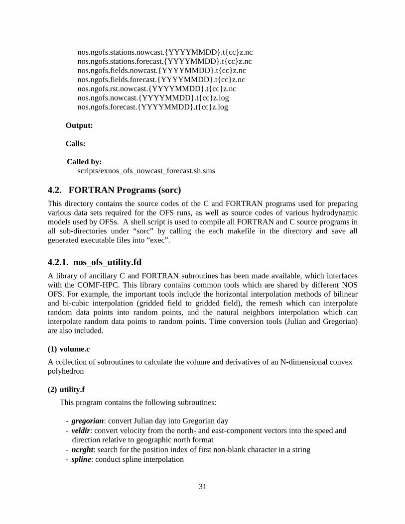
nos.ngofs.stations.nowcast.{YYYYMMDD}.t{cc}z.nc nos.ngofs.stations.forecast.{YYYYMMDD}.t{cc}z.nc nos.ngofs.fields.nowcast.{YYYYMMDD}.t{cc}z.nc nos.ngofs.fields.forecast.{YYYYMMDD}.t{cc}z.nc nos.ngofs.rst.nowcast.{YYYYMMDD}.t{cc}z.nc nos.ngofs.nowcast.{YYYYMMDD}.t{cc}z.log nos.ngofs.forecast.{YYYYMMDD}.t{cc}z.log
Output:
Calls:
Called by:
scripts/exnos_ofs_nowcast_forecast.sh.sms 4.2. FORTRAN Programs (sorc) This directory contains the source codes of the C and FORTRAN programs used for preparing various data sets required for the OFS runs, as well as source codes of various hydrodynamic models used by OFSs. A shell script is used to compile all FORTRAN and C source programs in all sub-directories under “sorc” by calling the each makefile in the directory and save all generated executable files into “exec”.
4.2.1. nos_ofs_utility.fd A library of ancillary C and FORTRAN subroutines has been made available, which interfaces with the COMF-HPC. This library contains common tools which are shared by different NOS OFS. For example, the important tools include the horizontal interpolation methods of bilinear and bi-cubic interpolation (gridded field to gridded field), the remesh which can interpolate random data points into random points, and the natural neighbors interpolation which can interpolate random data points to random points. Time conversion tools (Julian and Gregorian) are also included. (1) volume.c A collection of subroutines to calculate the volume and derivatives of an N-dimensional convex polyhedron (2) utility.f This program contains the following subroutines:
- gregorian: convert Julian day into Gregorian day - veldir: convert velocity from the north- and east-component vectors into the speed and
direction relative to geographic north format - ncrght: search for the position index of first non-blank character in a string - spline: conduct spline interpolation
31

- continuous: search for beginning and ending position indices of the longest continuous record in a given time series
- dist: calculate distance in meters between two geographical locations expressed in longitude and latitude
- sigma2Z_ROMS: convert the ROMS model vertical layer definition from the sigma-coordinate into the z-coordinate
- sigma2Z_SELFE: convert the SELFE model vertical layer definition from the sigma-coordinate into the z-coordinate
- sigma2Z_POM: convert the POM model vertical layer definition from the sigma-coordinate into the z-coordinate
- sigma2Z_ROMS_FIX: updated version of the sigma2Z_ROMS - one2twod: convert horizontal model grid indices from a one-dimensional index
expression into a two-dimensional index expression - two2twod: convert horizontal model grid indices from a two-dimensional index
expression into a one-dimensional index expression
(3) stack.c Defines a C-langauge ‘node’ object for tackling a single node case (4) stackpair.c
Defines a C-langauge ‘node’ object for tackling a pair of nodes case (5) interp_remesh.f
Interpolates z-values at given longitude, latitude locations from an input data set of (longitude, latitude, z). The input is not required to be a gridded data set.
(6) interp_regrid.f Interpolates z-values defined on one 2-D gridded field to another 2-D gridded field. (7) interp_nneighbor.f Interpolates z-values defined on a list of locations to another list of locations using the
natural neighbors interpolation technique. (8) libutility.a A binary library file formed from compiling the C/FORTRAN programs in this directory (9) makefile makefile to create a libnosutil.a by running command, gmake –f makefile 4.2.2. nos_ofs_reformat_ROMS_CTL.fd
(1) nos_ofs_reformat_ROMS_CTL.f
32

This program is used to reformat the ROMS runtime input parameter control file (ROMS.in).
Some ROMS runtime parameters for nowcast and forecast simulations need to be changed dynamically at the time to run.
Usage: called by nos_ofs_prep_roms_ctl.sh nos_ofs_reformat_ROMS_CTL < reformat_ROMS_CTL.ctl while reformat_ROMS_CTL.ctl is dynamically created in nos_ofs_prep_roms_ctl.sh (2) makefile
makefile is used to compile nos_ofs_reformat_ROMS_CTL.f
4.2.3. nos_ofs_read_restart.fd This program reads the ROMS model initial/restart file. If values and attributes of the
variable “ocean_time” are correct, then the initial file is not changed. Otherwise, the following actions may be conducted if needed:
(1) Change reference time (the attribute of “units”) of variable “ocean_time” in the initial file if
the reference time is difference from ${BASE_DATE} specified in the control file such as “nos.cbofs.ctl”, nos.dbofs.ctl, etc.
(2) Recompute the values of variable “ocean_time” using ${BASE_DATE} as the reference time in the initial file if (1) is conducted
(3) If the” ocean_time” is 48 hours less than ${time_nowcastend}, then the nowcast simulation is run from “cold_start” from 48 hours before ${time_nowcastend} by forcing the surface elevation and velocity to zero and keeping the water temperature and salinity structures in the initial file unchanged.
Usage: called nos_ofs_launch.sh nos_ofs_read_restart < Fortran_read_restart.ctl > Fortran_read_restart.log
while Fortran_read_restart.ctl is dynamically created in nos_ofs_launch.sh
4.2.4. nos_ofs_read_restart_fvcom.fd
This program reads the FVCOM model initial/restart files. If values and attributes of the variable “time” is correct, then the initial file is not changed. Otherwise, the following actions may be conducted if needed:
(1) Change reference time (the attribute of “units”) of variables “time” and “Itime” in the
initial file if the reference time is different from ${BASE_DATE} specified in the control file such as “nos.ngofs.ctl”, etc.
33

(2) Recompute the values of variables “time” and “Itime” using ${BASE_DATE} as the
reference time in the initial file if (1) is conducted.
(3) If the “time” is 48 hours less than ${time_nowcastend}, then the nowcast simulation is run from “cold_start” from 48 hours before ${time_nowcastend} by forcing the surface elevation and velocity to zero and keeping the water temperature and salinity structures in the initial file unchanged.
Usage: called nos_ofs_launch.sh nos_ofs_read_restart_fvcom < Fortran_read_restart.ctl > Fortran_read_restart.log
while Fortran_read_restart.ctl is dynamically created in nos_ofs_launch.sh
4.2.5. nos_ofs_read_restart.selfe_fd This program reads the the SELFE model initial/restart file (in binary). If the initial file is not two days older than ${time_nowcastend}, then the initial file is not changed. Otherwise, if the “time” in the initial file is 48 hours less than ${time_nowcastend}, then the nowcast simulation is run from “cold_start” from 48 hours before ${time_nowcastend} by forcing the surface elevation and velocity to zero and keeping the water temperature and salinity structures in the initial file unchanged.
Usage: called nos_ofs_launch.sh nos_ofs_read_restart_selfe < Fortran_read_restart.ctl > Fortran_read_restart.log
while Fortran_read_restart.ctl is dynamically created in nos_ofs_launch.sh
4.2.6. nos_ofs_met_file_search.fd nos_ofs_met_file_search.f is used to check the existence of the NCEP operational atmospheric products (NAM, GFS, or RTMA depending on the parameter of “DBASE_MET_NOW or DBASE_MET_FOR) for a given time period of interest. All file names of the most recently available meteorological products are written in an output file, such as NAM_FILE.dat if DBASE_MET_NOW=NAM.
Usage: called by nos_ofs_create_forcing_met.sh nos_ofs_met_file_search < Fortran_file_search.ctl > Fortran_file_search.log
While Fortran_file_search.ctl is dynamically created in nos_ofs_create_forcing_met.sh.sh, an example of “Fortran_file_search.ctl” for nowcast run is like, 2012010800 : Start Time of nowcast simulation 2012010812 : End Time of nowcast simulation
34

tmp.out : A temporary file created by nos_ofs_create_forcing_met.sh.sh which contains all meteorological operational files.
NAM_FILE.dat :File name for output which includes all file names used to generate OFS meteorological forcing conditions.
4.2.7. nos_ofs_create_forcing_met.fd nos_ofs_create_forcing_met.f is used to generate meteorological forcing conditions for NOS OFS which is based on the ROMS hydrodynamic model from the NCEP operational atmospheric products in GRIB2 format (NAM, GFS, or RTMA depending on the parameter of “DBASE_MET_NOW or DBASE_MET_FOR) for a given time period of interest. The output file is in standard NetCDF format for ROMS. Several options of horizontal interpolation are available to interpolate NCEP meteorological analyses or model outputs onto a NOS OFS model grid.
Usage: called by nos_ofs_create_forcing_met.sh nos_ofs_create_forcing_met < Fortran_met.ctl > NAM_Fortran.log
while Fortran_met.ctl is dynamically created in nos_ofs_create_forcing_met.sh.sh. An example of “Fortran_met.ctl” for nowcast run is like, cbofs : Name of NOS OFS NAM : Name of NCEP meteorological product ROMS : Name of hydrodynamic model 2012010912 : Start Time 2012011212 : End Time 0 : Option of horizontal spatial interpolation. 0: no interpolation (on native grid of NCEP product); 1: remesh method 2: bicubic method from ROMS 3: bilinear method from ROMS 4: nature neighbors method cbofs_NAM.grib2 : grib2 file generated in nos_ofs_create_forcing_met.sh nos.cbofs.romsgrid.nc : model grid file nos.cbofs.met.forecast.20120109.t12z.nc : file name of meteorological forcing 2009010100 : Base Date -82.0 : Minimum longitude of model domain 35.0 : Minimum latitude of model domain -73.0 : Maximum longitude of model domain 41.0 : Maximum latitude of model domain 1.0 : scaling factor (fraction) of surface heat flux (net short-wave and downward long-wave radiation). if =1.0, no adjustment to atmospheric products.
35

4.2.8. nos_ofs_create_forcing_met_fvcom.fd nos_ofs_create_forcing_met_fvcom.f generates meteorological forcing conditions for NOS OFS which is based on the hydrodynamic model of FVCOM or SELFE from the NCEP operational atmospheric products in GRIB2 format (NAM, GFS, or RTMA depending on the parameter of “DBASE_MET_NOW or DBASE_MET_FOR) for a given time period of interest. The output file is in standard NetCDF format for FVCOM or binary for SELFE. Several options of horizontal interpolation are available to interpolate NCEP meteorological products onto NOS OFS model grid.
Usage: called nos_ofs_create_forcing_met.sh nos_ofs_create_forcing_met_fvcom < Fortran_met.ctl > NAM_Fortran.log
while Fortran_met.ctl is dynamically created in nos_ofs_create_forcing_met.sh. An example of “Fortran_met.ctl” for nowcast run is like, ngofs : Name of NOS OFS NAM : Name of NCEP meteorological product FVCOM : Name of hydrodynamic model 2012010912 : Start Time 2012011212 : End Time 1 : Option of horizontal spatial interpolation. 0: no interpolation (on native grid of NCEP product); 1: remesh method 2: bicubic method from ROMS 3: bilinear method from ROMS 4: nature neighbors method ngofs_NAM.grib2 : grib2 file generated in nos_ofs_create_forcing_met.sh nos.ngofs.grid.dat : model grid file nos.ngofs.met.forecast.20120109.t12z.nc : file name of meteorological forcing 1858111700 : Base Date -99.0 : Minimum longitude of model domain 25.0 : Minimum latitude of model domain -82.0 : Maximum longitude of model domain 32.0 : Maximum latitude of model domain 1.0 : scaling factor (fraction) of surface heat flux (net short-wave and downward long-wave radiation). if =1.0, no adjustment to atmospheric products.
4.2.9. nos_ofs_create_forcing_river.fd nos_ofs_create_forcing_river.f generates river forcing conditions for NOS OFSs which are based on ROMS, FVCOM, or SELFE hydrodynamic model from real time river discharge, and temperature and salinity observations at USGS and NOS NWLON gauges in WCOSS data tank (BUFR format). The climatological river dataset (multiple-year daily mean from USGS) are used in cases when either no real-time observations are available in the simulation time period or the
36

River_Flag in the river control file is set to zero. For the forecast simulation, the river forcing conditions are derived using persistence of the most recently available real-time observations.
Usage: called nos_ofs_create_forcing_river.sh nos_ofs_create_forcing_river < Fortran_river.ctl > Fortran_river.log while Fortran_river.ctl is dynamically created in nos_ofs_create_forcing_river.sh. An example of “Fortran_met.ctl” for nowcast run is like, ngofs : Name of NOS OFS FVCOM : Name of hydrodynamic model 201201091200 : Start Time (YYYYMMDDHHMN) 201201121200 : End Time (YYYYMMDDHHMN) nos.ngofs.grid.nc : model grid file /dcom/us007003 : Directory Name where BUFR files of USGS and NOS real-time observations xx012 : BUFR file name of NOS real-time observations in CCS data tank xx009 : BUFR file name of USGS real-time observations in CCS data tank /nwprod/ngofs.v1.0.0/fix : Directory Name of NGOFS fix files are located nos.ngofs.river.ctl : NGOFS river control file nos.ofs.river.clim.usgs.nc : river climatological NetCDF file nos.ngofs.river.20120110.t12z.nc.tar : Output river forcing file 1858111700 : Base Time used by NGOFS 40 : Vertical layers of NGOFS nos.ngofs.corms.20120110.t12z.log : CORMS log file
4.2.10. nos_ofs_create_forcing_obc_tides.fd nos_ofs_create_forcing_obc_tides.f generates tidal forcing file for ROMS from the ADCIRC EC2001 database generated by CSDL. The data (Harmonic Constants of EL, UBAR, and VBAR) on the ADCIRC grid are horizontally interpolated onto water cells of the OFS model grid using a remesh routine. “Node factor” and “equilibrium arguments” for the middle of each year (day 183 or 184) are used in the same calendar year regardless of the length of the time series. This is consistent with CO-OPS tidal prediction programs. The final harmonics can be corrected with user provided data. The output is a NetCDF file in the standard format for ROMS’ open boundary tidal forcing file.
Usage: called nos_ofs_create_forcing_obc.sh nos_ofs_create_forcing_obc_tides < Fortran_Tide.ctl > Fortran_Tide.log
while Fortran_Tide.ctl is dynamically created in nos_ofs_create_forcing_obc.sh. An example of “Fortran_Tide.ctl” is like, cbofs : Name of NOS OFS ROMS : Name of hydrodynamic model
37

201201091200 : Start Time (YYYYMMDDHHMN) nos.cbofs.romsgrid.nc : model grid file nos.cbofs.HC.nc : File Name of Tidal Harmonic constants nos.cbofs.roms.tides.nc : Output tidal open boundary forcing file 2009010100 : Base Time used by NGOFS
4.2.11. nos_ofs_create_forcing_obc.fd nos_ofs_create_forcing_obc.f generates the lateral open boundary forcing file for ROMS. Tides are provided by the ADCIRC EC2001 database generated by CSDL. Nontidal water level open boundary conditions can be derived from either the G-RTOFS, HYCOM, or ETSS operational forecast products depending upon the parameter of “DBASE_WL”. Open boundary conditions of water temperature and salinity are derived from either G-RTOFS, or HYCOM, or WOA climatological data set from the National Oceanographic Data Center. The data of G-RTOFS/HYCOM products, ETSS, or WOA are horizontally interpolated onto water cells of the OFS model grid cells using either, the remesh routine, or natural neighbors, or bicubic, or bilinear method depending upon the parameter of “IGRD_OBC”, and then linearly interpolated onto the model vertical coordinates. The output is a NetCDF file in the standard format for the ROMS open boundary forcing file.
Usage: called nos_ofs_create_forcing_obc.sh nos_ofs_create_forcing_obc < Fortran_OBC.ctl > Fortran_OBC.log
while Fortran_OBC.ctl is dynamically created in nos_ofs_create_forcing_obc.sh. An example of “Fortran_OBC .ctl” is like, cbofs :Name of NOS OFS ROMS : Name of hydrodynamic model ETSS : Product Name for nontidal water level OBC cbofs.ETSS : file name generated by nos_ofs_create_forcing_obc.sh RTOFS : Product Name for T&S OBC xx012 : BUFR file name of NOS real-time observations in CCS data tank xx009 : BUFR file name of USGS real-time observations in CCS data tank /dcom/us007003 : Directory of NCOM forecasts are saved /dcom/us007003 : Directory of USGS and NOS real-time observations are saved 201201041200 : Start Time (YYYYMMDDHHMN) 201201071200: : End Time (YYYYMMDDHHMN) 1 : Option of horizontal interpolation method /nwprod/cbofs.v1.0.0/fix : Directory of OFS fix files are saved nos.cbofs.romsgrid.nc : Model grid file nos.cbofs.roms.tides.nc : tidal OBC file nos.cbofs.obc.ctl : OFS OBC control file nos.ofs.clim.WOA05.nc : T & S climatological NetCDF file from NODC nos.cbofs.obc.20120105.t12z.nc : OBC forcing file name for output nos.cbofs.corms.20120105.t12z.log : OFS runtime CORMS log file 2009010100 : Base Time used by OFS
38

-82.0 : Minimum longitude of model domain 35.0 : Minimum latitude of model domain -73.0 : Maximum longitude of model domain 41.0 : Maximum latitude of model domain
20 : KBm vertical layers 4.5d0 : THETA_S 0.95d0 : THETA_B 10.0d0 : TCLINE
NCOM_FILE : A temporary file generated by nos_ofs_create_forcing_obc.sh 4.2.12. nos_ofs_create_forcing_obc_fvcom.fd nos_ofs_create_forcing_obc_fvcom.f generates the lateral open boundary forcing file for the FVCOM hydrodynamic ocean model. Tides are provided by the ADCIRC EC2001 database generated by CSDL. Nontidal water level open boundary conditions are derived from either the G-RTOFS, or HYCOM, or the Extra-tropical Storm Surge (ETSS) operational forecast products based on the parameter of “DBASE_WL”. Open boundary conditions of water temperature, salinity, and baroclinic velocity are derived from the G-RTOFS with the Navy HYCOM and WOA climatology as backup. The data of G-RTOFS, HYCOM products, ETSS, or WOA are horizontally interpolated onto water cells of the OFS model grid cells using either, the remesh routine, natural neighbors, bicubic, or bilinear method depending upon the parameter of “IGRD_OBC”, and then linearly interpolated onto model vertical coordinates. The output is a NetCDF file in the standard format for the FVCOM open boundary forcing file.
Usage: called by nos_ofs_create_forcing_obc.sh nos_ofs_create_forcing_obc_fvcom < Fortran_OBC.ctl > Fortran_OBC.log
while Fortran_OBC.ctl is dynamically created in nos_ofs_create_forcing_obc.sh. An example of “Fortran_OBC .ctl” is like, ngofs :Name of NOS OFS FVCOM : Name of hydrodynamic model RTOFS : Product Name for nontidal water level OBC ngofs.ETSS : file name generated by nos_ofs_create_forcing_obc.sh NCOM : Product Name for T&S OBC xx012 : BUFR file name of NOS real-time observations in CCS data tank xx009 : BUFR file name of USGS real-time observations in CCS data tank /dcom/us007003 : Directory of NCOM forecasts are saved /dcom/us007003 : Directory of USGS and NOS real-time observations are saved 201201101200 : Start Time (YYYYMMDDHHMN) 201201131200: : End Time (YYYYMMDDHHMN) 1 : Option of horizontal interpolation method /nwprod/ngofs.v1.0.0/fix : Directory of OFS fix files are saved nos.ngofs.grid.dat : Model grid file nos.ngofs.HC.nc : tidal OBC file nos.ngofs.obc.ctl : OFS OBC control file
39

nos.ofs.clim.WOA05.nc : T & S climatological NetCDF file from NODC nos.ngofs.obc.20120110.t12z.nc : OBC forcing file name for output nos.ngofs.corms.20120110.t12z.log : OFS runtime CORMS log file 1858111700 : Base Time used by OFS
-99.0 : Minimum longitude of model domain 25.0 : Minimum latitude of model domain -82.0 : Maximum longitude of model domain 32.0 : Maximum latitude of model domain
40 : KBm vertical layers nos.ngofs.vgrid.dat : vertical coordinate configuration file
NCOM_FILE : A temporary file generated by nos_ofs_create_forcing_obc.sh 4.2.13. nos_ofs_create_forcing_obc_selfe.fd nos_ofs_create_forcing_obc_selfe.f generates the lateral open boundary forcing file for the SELFE hydrodynamic ocean model. Tides are provided by the ADCIRC EC2001 database generated by CSDL. The nontidal water level open boundary conditions are derived from either the G-RTOFS, or Navy’s HYCOM or Extra-tropical Storm Surge (ETSS) operational forecast products based on the parameter of “DBASE_WL”. Open boundary conditions of water temperature and salinity are derived from either the G-RTOFS, or Navy’s HYCOM, or climatological data set of World Ocean Atlas (WOA) from the National Oceanographic Data Center (NODC) depending upon parameter of “DBASE_TS”. The data of G-RTOFS, HYCOM, ETSS products, or WOA are horizontally interpolated onto water cells of the OFS model grid using either, the remesh routine, natural neighbors, bicubic, or bilinear method depending upon the parameter of “IGRD_OBC”, and then linearly interpolated onto model vertical coordinates. The output includes two binary files of “temp_nu.in” and “salt_nu.in” and a direct access file of “elev3D.th” which are in the standard format for the SELFE open boundary forcing file.
Usage: called by nos_ofs_create_forcing_obc.sh nos_ofs_create_forcing_obc_selfe < Fortran_OBC.ctl > Fortran_OBC.log
while Fortran_OBC.ctl is dynamically created in nos_ofs_create_forcing_obc.sh. An example of “Fortran_OBC .ctl” is like, creofs :Name of NOS OFS SELFE : Name of hydrodynamic model NCOM : Product Name for nontidal water level OBC creofs.ETSS : file name generated by nos_ofs_create_forcing_obc.sh NCOM : Product Name for T&S OBC xx012 : BUFR file name of NOS real-time observations in CCS data tank xx009 : BUFR file name of USGS real-time observations in CCS data tank /dcom/us007003 : Directory of NCOM forecasts are saved /dcom/us007003 : Directory of USGS and NOS real-time observations are saved 201201101200 : Start Time (YYYYMMDDHHMN) 201201131200: : End Time (YYYYMMDDHHMN) 1 : Option of horizontal interpolation method
40

/nwprod/creofs.v1.0.0/fix : Directory of OFS fix files are saved nos.creofs.hgrid.ll : Model grid file nos.creofs.HC.nc : tidal OBC file nos.creofs.obc.ctl : OFS OBC control file nos.ofs.clim.WOA05.nc : T & S climatological NetCDF file from NODC nos.creofs.obc.20120110.t12z.nc : OBC forcing file name for output nos.creofs.corms.20120110.t12z.log : OFS runtime CORMS log file 2012011018 : Base Time used by OFS
-128.5 : Minimum longitude of model domain 38.50 : Minimum latitude of model domain -121.0 : Maximum longitude of model domain 50.25 : Maximum latitude of model domain
54 : KBm vertical layers nos.creofs.vgrid.in : vertical coordinate configuration file
NCOM_FILE : A temporary file generated by nos_ofs_create_forcing_obc.sh nos.creofs.t_nudge.gr3 : File name which contains weighting factors for T & S nudging The former holds the hydrodynamic model programs. The latter contains hydrodynamic data files and OFS model-related input and control files. For details about the files in the ocean_model directory, readers are recommended to read the corresponding model user manuals.
41

42

5. IMPLEMENTATION OF OFS OPERATIONS The NOS OFS operations are implemented on the NCEP HPC systems. As described in Section 1.3, the process involves two steps: (1) preparing the OFS model input files, and (2) conducting nowcast/forecast runs and archiving and disseminating the OFS files.
This section describes how each step is executed through computer programming in the COMF-HPC environment. This section is organized in the following manner: Section 5.1 presents details on how each individual OFS model input file is created; Sections 5.2 and 5.3 illustrate the implementations of the nowcast and forecast runs, respectively; and Section 5.4 describes details about the file archive.
Figure 5.1 shows how each step is implemented. A new cycle run for any given OFS is launched from a SMS script which calls a J-JOB script of “JNOS_OFS_PREP.sms.dev. Subsequently “JNOS_OFS_PREP.sms.dev calls a script of “exnos_ofs_prep.sh” to execute other scripts. Another SMS script “jnos_ngofs_nowcast_fcst_${CC}.sms is triggered after PREP jobs are successfully completed. After nowcast and forecast runs complete successfully, the main script finally calls the nos_ofs_archive.sh to archive various files created during the data preparation and nowcast/forecast runs. The files include the model input files, output files from the nowcast/forecast runs, and various system log files.
5.1. Creation of Model Input Files 5.1.1. File Descriptions To run a numerical hydrodynamic model, four types of input files are needed (initial conditions, surface meteorological forcing, lateral open ocean boundary forcing, and river forcing). The task of the input file preparation is to generate all required forcing conditions from other model forecasts and real-time observations archived in the NCEP data tanks (Section 2.1) using spatial interpolation techniques. Occasionally, when the non-climatological data are unavailable, the climatological data generated from historical datasets archived in the COMF-HPC core directories are used. The following is a list of input files and their contents for any given OFS model. Here and in subsequent sections all variables are labeled in brackets and expressed in italics.
a) nos.{OFS}.init.nowcast.{yyyymmdd}.t.{cc}.z.nc An initial condition file, whose properties vary with specific model requirements. In general, they include water temperature, salinity, density, viscosity/diffusivity, water level and velocity.
b) nos.{OFS}.met.{runType}.{yyyymmdd}.t.{cc}.z.nc For runType = nowcast, it contains Uwind, Pair, Tair, and Qair For runType = forecast, it contains Uwind, Pair, Tair, Radsw,net Radlw,down
43
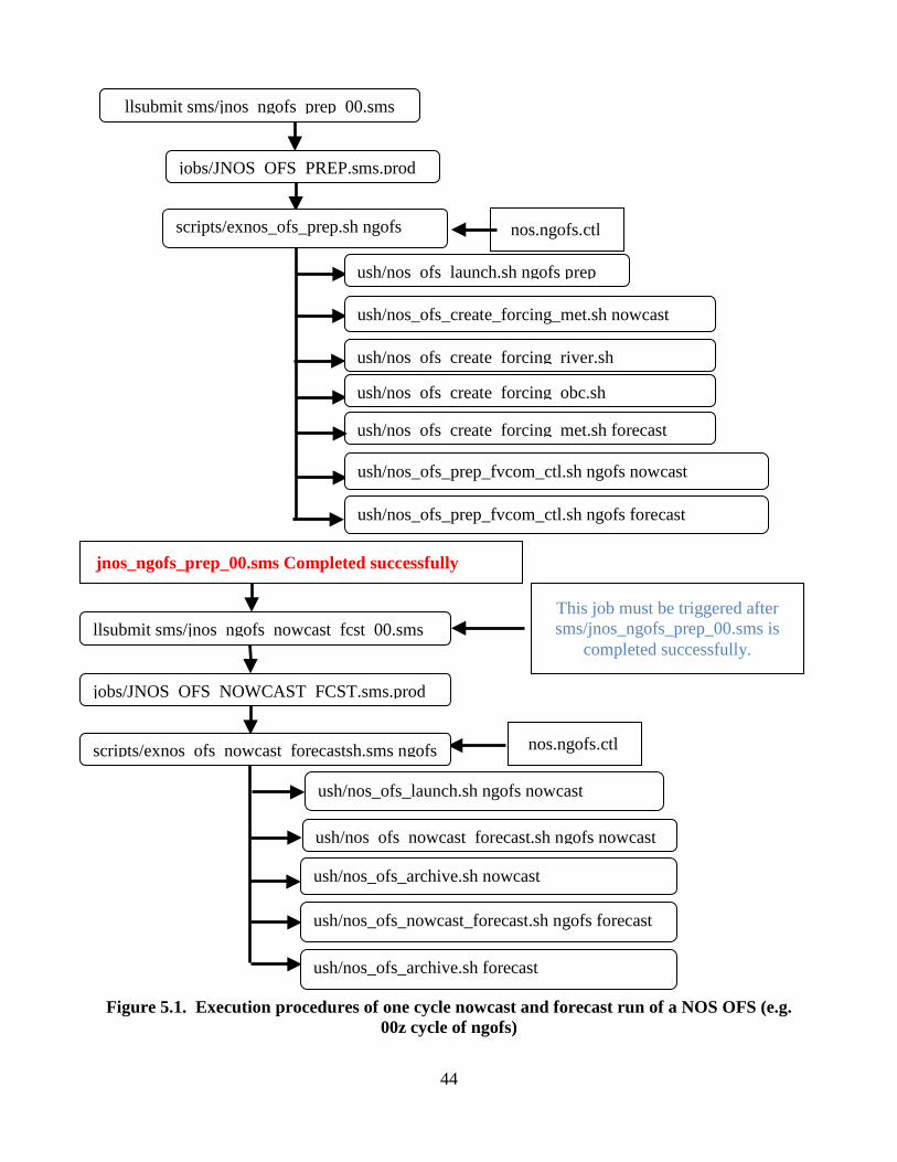
Figure 5.1. Execution procedures of one cycle nowcast and forecast run of a NOS OFS (e.g. 00z cycle of ngofs)
nos.ngofs.ctl
jobs/JNOS OFS PREP.sms.prod
This job must be triggered after sms/jnos_ngofs_prep_00.sms is
completed successfully.
llsubmit sms/jnos ngofs prep 00.sms
scripts/exnos_ofs_prep.sh ngofs
ush/nos ofs launch.sh ngofs prep
ush/nos_ofs_create_forcing_met.sh nowcast
ush/nos ofs create forcing river.sh
ush/nos ofs create forcing obc.sh
ush/nos ofs create forcing met.sh forecast
ush/nos_ofs_prep_fvcom_ctl.sh ngofs nowcast
llsubmit sms/jnos ngofs nowcast fcst 00.sms
ush/nos_ofs_prep_fvcom_ctl.sh ngofs forecast
jobs/JNOS OFS NOWCAST FCST.sms.prod
scripts/exnos ofs nowcast forecastsh.sms ngofs
nos.ngofs.ctl
ush/nos_ofs_launch.sh ngofs nowcast
ush/nos ofs nowcast forecast.sh ngofs nowcast
jnos_ngofs_prep_00.sms Completed successfully
ush/nos_ofs_nowcast_forecast.sh ngofs forecast
ush/nos_ofs_archive.sh nowcast
ush/nos_ofs_archive.sh forecast
44

c) nos.{OFS}.hflux.nowcast.{yyyymmdd}.t{cc}z.nc Radsw,net Radlw,down
d) nos.{OFS}.obc.{yyyymmdd}.t{cc}z.nc open boundary forcing data including time series of T, S, and subtidal water level
e) nos.{OFS}.river.{yyyymmdd}.t{cc}z.nc river discharge data including runoff rate, and water T/S.
f) nos.ofs. {OFS}.{model}.tides.nc (only for ROMS-based OFS): tidal forcing data including harmonic constants, real-time nodal factors and equilibrium arguments information
5.1.2. Flow Chart of Execution The J-job of “JNOS_OFS_PREP.sms.dev” (Figure 5.1) acts as the task script to actually create the model input files. Figure 5.2 illustrates the implementation of the top level logic involved in the task.
As shown in Figure 5.2, the SMS script jnos_ofs_prep_{cc}.sms invokes a call to the task script JNOS_OFS_PREP.sms.dev, which then calls a shell script file, nos_ofs_launch.sh (Section 4.1) to specify the initial condition file for the OFS model. It first checks the existence of the model hot restart file for the present OFS nowcast run cycle, if it exists, the file will be designated as the initial condition file; otherwise, the script will search backward in time within a 60-hour window for the most recently created restart file. If still no restart file is found, the cold start file archived in /nwprod/{OFS}.v1.0.0/fix/nos.{OFS}.init.nc will be designated as the model initial condition file. After execution of nos_ofs_launch.sh, path names, input and output files names, start and end times, and many runtime parameters are dynamically determined.
The task script then makes script calls to create the surface forcing file for the nowcast run, river and open boundary forcing files for both the nowcast and forecast run, reformat the standard ROMS model control file to reflect the real time information regarding the present nowcast and forecast cycles, respectively; and finally create the surface forcing file for the forecast run.
45

The following sections describe how each of the above model input files is created.
Figure 5.2. Logic procedures to prepare model forcing input files.
nos.ngofs.ctl
jobs/JNOS_OFS_PREP.sms.dev
scripts/exnos_ofs_prep.sh ngofs
ush/nos ofs launch.sh ngofs prep
ush/nos_ofs_create_forcing_met.sh nowcast
ush/nos ofs create forcing river.sh
ush/nos ofs create forcing obc.sh
ush/nos ofs create forcing met.sh forecast
ush/nos_ofs_prep_fvcom_ctl.sh ngofs nowcast
ush/nos_ofs_prep_fvcom_ctl.sh ngofs forecast
jnos_ngofs_prep_00.sms Completed successfully
llsubmit sms/jnos_ngofs_prep_00.sms
46

5.1.3. Generating Meteorological Surface Forcing Files A call to the shell script, nos_ofs_forcing_met.sh nowcast, creates surface forcing files for the nowcast simulation. Figure 5.3 illustrates the implementation procedures. It first creates a control file, Fortran_file_search.ctl (see Appendix 5 for an example file), which serves as the input file to the subsequent call of the executable, nos_ofs_met_file_search (Section 4.2.6). The control file specifies the nowcast timeframe (8 hours backward from the current time) and the default type (specified by variable, DBASE_MET_NOW; see section on COMF-HPC variables) of the meteorological products.
The nos_ofs_met_file_search scans through the NCEP data tank (Section 2.1) for files satisfying the time frame and type requirements. For various types of products, it first searches for the default type specified by DBASE (listed in the control file; as a default, DBASE = NAM4); if the default type of files does not exist, the script then checks the backup data sources such as NAM and GFS products. In the case where no data are found, the surface forcing files will not be created. As a result, the present cycle of the OFS nowcast and forecast runs will stop due to a lack of surface forcing data. In the normal case, it finds the right data sets and outputs an ASCII file, {DBASE}_FILE.dat which contains a list of files to be processed and a log file Fortran_file_search.log.
The nos_ofs_forcing_met.sh then creates a control file, Fortran_met.ctl (see Appendix 1 for an example) for the executable nos_ofs_create_forcing_met (Section 4.2.7). It should be noted that the {DBASE}_FILE.dat created by nos_ofs_met_file_search is referenced in Fortran_met.ctl (see Appendix 1 for an example). The nos_ofs_create_forcing_met then creates the final surface forcing files for nowcast and forecast simulations,
nos.{OFS}.met.nowcast|forecast.{yyyymmdd}.t{cc}z.nc and nos.{OFS}.met.nowcast|forecast.{yyyymmdd}.t{cc}z.nc as well as a log file, Fortran_met.log.
Itshould be noted that parameters contained in the above two NetCDF files vary with the OFS because the input formats for ROMS, FVCOM, and SELFE are different.
5.1.4. Generating River Forcing File Shell script, nos_ofs_create_forcing_river.sh, creates the river forcing file covering both the nowcast and forecast periods (Section 1.2) from the beginning and ending dates/times of the combined entire period.
Figure 5.4 illustrates the implementation details. The script first creates an input control file, Fortran_river.ctl (See Appendix 4 for an example), for the FORTRAN program of, nos_ofs_create_river_forcing.f. The FORTRAN program creates the river input file(s), nos.{OFS}.river.{yyyymmdd}.t{cc}z.nc, and a log file called Fortran_river.log.
It is noted that the river data originate from the USGS real-time observations, which are available for a time frame prior to the current time. This only covers the nowcast period. For the forecast period, the river discharge time series are persisted with a single value from the most recent observation. The persisted river discharges might be inaccurate model forecasts, especially
47

during extreme flooding events. Therefore, river stage and discharge forecast guidance from NWS River Forecast Centers would be a better solution for the forecast cycle simutions in the future.
5.1.5. Generating Open Boundary Forcing Files The shell script, nos_ofs_create_forcing_obc.sh, creates the open boundary forcing file, which contains total water-level (tidal plus subtidal components) and T/S time series. Similar to the river forcing file case, this file covers both the nowcast and forecast periods and hence is used by both the nowcast and forecast simulations.
The diagram shown in Figure 5.5 illustrates the file creation details. The process includes two steps: (1) generations of a tidal harmonic constant database and (2) forming a total water level time-series through integrating tidal and subtidal water level and T and S time series.
First, the nos_ofs_create_forcing_obc.sh creates an input control file, Fortran_Tide.ctl (see Appendix 3 for an example file), for nos_ofs_create_forcing_obc_tides (Section 4.2.10). The latter creates a tidal harmonic constant database file, nos.{OFS}.roms.tides.nc,with the real-time nodal factor and equilibrium argument information and a log file Fortran_Tide.log.
Secondly, the nos_ofs_create_forcing_obc.sh creates a control file, Fortan_OBC.ctl (see Appendix 2 for an example file), as an input to the compiled executable, nos_ofs_create_forcing_obc. Note that the aforementioned created database filename nos.ofs.dbofs.roms.tides.nc is referenced in this control file for ROMS-based OFS.
The nos_ofs_create_forcing_obc populates three time series, (1) tidal predictions using the NOS standard tidal prediction software package; (2) subtidal water levels; and (3) T and S time series on the model open ocean boundary. Time series (1) is straightforward. Time series (2) involves the integration of oceanic numerical model products (Section 2.1) and real-time NOS NWLON observational data (Section 2.1). First subtidal water level time series are derived from interpolating subtidal water level predictions from G-RTOFS/HYCOM or ETSS. While the interpolated series give remarkably accurate subtidal water level relationships between various sites along the model boundary, the absolute levels need to be adjusted by referencing observational data. The subtidal water level time series (after detiding the observed total water level data) from near-boundary NWLON stations are used to make the adjustment. However, this only covers the time frame prior to the current time. Therefore, the real-time adjustment applies only for the nowcast period. For the forecast period, the adjustment is done by applying an average of the non-tidal water level observations during the corresponding nowcast period. Then the adjusted subtidal water levels are then superimposed with the predicted tidal series to form the total water level time series.
The T and S time series (3) are interpolated from the G-RTOFS model results (Section 2.1). Similar to the subtidal water level adjustment, the nowcast period data are adjusted by referencing NOS T and S observations at the near-boundary stations; the forecast period adjustment is conducted by applying the nowcast period averages of T and S. For FVCOM-based OFS, velocity open boundary conditions are normally required and derived from G-RTOFS/HYCOM products and tidal model products such as EC2001.
48

5.1.6. Generating Model Runtime Input Files Figure 5.6 illustrates a procedure to create runtime input control files for both nowcast and forecast simulations. The shell script, nos_ofs_prep_roms|fvcom|selfe_ctl.sh nowcast, creates all required runtime control files for a model run. For ROMS-based OFSs, it first creates two ASCII files, ROMS_INPUT.dat and reformat_ROMS_CTRL.ctl. The latter is the input file to the compiled executable, nos_ofs_reformat_ROMS_CTL (Section 4.2.2), whereas the former is referenced by the latter. The script then calls the executable to create an updated ROMS model standard input file {OFS}_ROMS_nowcast.in (Section 11), for the OFS nowcast run.
Figure 5.3. Procedures to create the surface forcing file for the nowcast run.
Figure 5.4. Procedures to create the river forcing file.
ush/nos_ofs_create_forcing_river.sh
exec/nos_ofs_create_river_forcing
Fortran_river.ctl
Fortran_river.log
nos.ofs.{OFS}.river.{yyyymmdd}.t{cc}z.nc
ush/nos_ofs_create_forcing_met.sh nowcast
exec/nos_ofs_met_file_search
exec/nos_ofs_create_forcing_met
Fortran_file_search.ctl
Fortran_met.ctl
{DBASE}_File.dat
{DBASE}_Fortran.log
Fortran_file_search.log
nos.ofs.{OFS}.met.nowcast.{yyyymmdd}.t{cc}z.nc nos.ofs.{OFS}.hflux.nowcast.{yyyymmdd}.t{cc}z.
49

Figure 5.5. Procedures to create the model open boundary forcing file.
Figure 5.6 Procedures to reformat the ROMS nowcast run input file
ush/nos_ofs_reformat_ROMS_ctl.sh {OFS} nowcast
exec/nos_ofs_reformat_ROMS_CTL
{MODEL}_INPUT.dat
{OFS}_ROMS_nowcast.in
Reformat_ROMS_CTL.ctl
ush/nos_ofs_create_forcing_obc.sh
exec/nos_ofs_create_forcing_obc_tides
nos_ofs_create_forcing_obc nos_ofs_create_forcing_obc_fvcom nos_ofs_create_forcing_obc_selfe
Fortran_Tide.ctl
Fortran_OBC.ctl
Fortran_OBC.log
Fortran_Tide.log
nos.ofs.{OFS}.river.{yyyymmdd}.t{cc}z.nc
50

5.2. Execution of Nowcast/Forecast Simulations Figure 5.7 illustrates the implementation of OFS nowcast/forecast runs. It begins with a submission of a SMS job script, jnos_ofs_nowcast.sms, which invokes a task script, JNOS_OFS_NOWCAST_FCST.sms.dev (see section 4.1.2). It first defines path and file names, then invokes a script file, exnos_ofs_nowcast_forecast.sh.sms, which calls nos_ofs_launch.sh (Section 4.1.4) to copy various static (in the fix directory) and parameter (in the parm directory) files to the work directory. nos_ofs_launch.sh also checks availability of restart files generated from previous nowcast cycle to prepare initial condition files for simulation of the current nowcast cycle. After the above preparation steps, jnos_ofs_nowcast.sms.prod calls exnos_ofs_nowcst_forecast.sh. The latter checks for the existence of various model input files (Section 4.1.4); if all the files are available, it then invokes the compiled hydrodynamic model executable, {OFS}_roms_mpi to start the actual nowcast run. The model run generates the following three standard model output files:
(1) nos.{OFS}.stations.nowcast.${yyyymmdd}.t${cc}.nc, (2) nos.{OFS}.fields. nHHH.${yyyymmdd}.t${cc}.nc, (3) nos.{OFS}.rst.nowcast.${yyyymmdd}.t${cc}.nc,
and a log file, {OFS}_nowcast.log. HHH represents nowcast hours in three digits.
51

Figure 5.7. Diagram of nowcast and forecast simulation runs.
llsubmit sms/jnos_ngofs_nowcast_fcst_{cc}.sms
ush/nos_ofs_launch.sh $OFS $runtype
scripts/exnos_ofs_nowcst_forecast.sh.sms $OFS
${OFS}OFS}.v1.0.0/fix/nos.{OFS}.ctl
work/${OFS}_nowcast.log
nos.{OFS}.stations.nowcast.${yyyymmdd}.t${cc}.nc nos.{OFS}.fields.nHHH.${yyyymmdd}.t${cc}.nc nos.{OFS}.rst. nowcast.${yyyymmdd}.t${cc}.nc nos.{OFS}.stations.forecast.${yyyymmdd}.t${cc}.nc nos.{OFS}.fields. fHHH.${yyyymmdd}.t${cc}.nc
jobs/ JNOS_OFS_NOWCST_FCST.sms.prod
ush/nos_ofs_nowcst_forecast.sh nowcast
ush/nos_ofs_archive.sh nowcast
ush/nos_ofs_nowcst_forecast.sh forecast
work/${OFS}_nowcast.log
ush/nos_ofs_archive.sh forecast
52

6. WORK DIRECTORY The work directory is where all input and output, and intermediate files generated during job script execution are saved. The name of the work directory is defined by a variable of “DATA” in the job scripts of “JNOS_OFS_PREP.sms.prod and JNOS_OFS_NOWCST_FCST.sms.prod. In development mode, the work directory is dynamically defined as /ptmp/{LOGNAME}/${OFS}.${model_ver}/{OFS}/${job}.${pid} on the NCEP CCS. In production mode, the name of work directory is dynamically defined as “/tmpnwprd/${job}.${pid}”. Apart from a few static files involved with the OFS model set up, the vast majority of the files are created during OFS executions and therefore are updated dynamically. In general, they are classified into the following categories (in the following, files in the cbofs directory are taken as an example): 6.1. Static Input Files
(1) Static files
The following files are a subset of the entire suite of model input files, which are unvaried with OFS execution types and cycles. They are copied from the directory, ${FIXofs} (e.g. ngofs.v1.0.0/fix for ngofs), and detailed file explanations are given in Section 2.3. - nos.{OFS}.{MODEL}grid.nc - nos.{OFS}.stations.in - nos.{OFS}.HC.nc - nos.{OFS}.obc.ctl - nos.{OFS}.river.ctl - nos.ofs.{MODEL}.varinfo.dat - nos.{OFS}.{MODEL}.in
(2) Forcing data files The following files are a subset of the entire suite of model input files, which are generated prior to the OFS nowcast/forecast runs by the data preparation programs. They are constantly updated for each cycle of the OFS runs.
- nos.{OFS}. init.nowcast.{yyyymmdd}.t{cc}z.nc: initial condition for the OFS nowcast run - nos.{OFS}.{MODEL}.tides.nc tidal harmonic constants with nodal factor and equilibrium information - nos.{OFS}.obc.{yyyymmdd}.t{cc}z.nc: Open boundary forcing data - nos.{OFS}. river.{yyyymmdd}.t{cc}z.nc: River forcing data - nos.{OFS}. met.{runType}.{yyyymmdd}.t{cc}z.nc: Meteorological surface forcing data - nos.{OFS}.hflux.{runType}.{yyyymmdd}.t{cc}z.nc: Surface heat flux data
53

6.2. Temporary Control Files For Preparation programs The following are control files used by the model data preparation FORTRAN programs. See their corresponding example files at appendixes 1-5.
(1) Fortran_met.ctl Purpose: input file to exec/nos_ofs_create_forcing_met Created by: scripts/exnos_ofs_create_forcing_obc.sh
(2) Fortran_Tide.ctl Purpose: input file to exec/ nos_ofs_create_forcing_obc_tides Created by: scripts/exnos_ofs_create_forcing_obc.sh
(3) Fortran_OBC.ctl Purpose: input file to exec/nos_ofs_create_forcing_obc Created by: scripts/exnos_ofs_create_forcing_obc.sh
(4) Fortran_river.ctl Purpose: input file to exec/nos_ofs_create_forcing_river Created by: scripts/exnos_ofs_create_forcing_obc.sh
(5) reformat_{MODEL}_CTL.ctl Purpose: input file to nos_ofs_reformat_{MODEL}_CTL Created by: scripts/exnos_ofs_create_forcing_obc.sh
(6) Fortran_search_met.ctl Purpose: input file to exec/nos_ofs_search_met Created by: scripts/exnos_ofs_search_met.sh
(7) Fortan_read_restart.ctl Purpose: file to exec/nos_ofs_read_restart Created by: scripts/exnos_ofs_create_read_restart.sh
6.3. Ocean Model Input Files (1) {OFS}_roms_{runType}.in
Each OFS model is associated with a static model input parameter file, fix/nos_ofs/nos.{OFS}.ROMS.in (Section 3.2). The reformatted model input files is an update of the standard input file with updated model parameter specifications.
(2) ROMS_INPUT.dat It contain specifications on the model run parameters, such as the time frame, input and output filenames of the current OFS run cycle. This file is reference by {OFS}_roms_{runType}.in.
54

6.4. Temporary Log Files The follow are log files of screen outputs from either the OFS model data preparation programs or the nowcast/forecast OFS model runs.
(1) read_hotrestart.log log file from executing exec/nos_ofs_read_restart (2) Fortran_river.log Log file from executing exec/nos_ofs_create_forcing_river (3) Fortran_Tide.log Log file from executing exec/nos_ofs_create_forcing_obc_tides (4) Fortran_OBC.log Log file from executing exec/nos_ofs_create_forcing_obc (5) Fortran_file_search.log Log file from executing exec/nos_ofs_met_file_search (6) {DBASE}_Fortran.log Log file from executing exec/nos_ofs_create_forcing_met, where $ncep_metProd =
{NAM, RTMA} (7) {OFS}_{runType}nowcast.log Log file from executing {MODEL}/{OFS}_{MODEL}_mpi (8) Fortran_met.ctl Log file from executing exec/nos_ofs_create_forcing_met (9) Fortran_Tide.ctl Log file from executing exec/nos_ofs_create_forcing_obc_tides
55

56

7. FILE ARCHIVING File archiving is performed after the OFS nowcast and forecast runs. Archiving is executed by invoking a call to the shell script, nos_ofs_archive.sh. This script simply makes copies of some core model forcing files and model output files from the work directory ({DIR_work}) to the archive directory ({DIR_archive}). The naming convention for the archive directory is /com/nos/prod/$OFS.}.${yyyymmdd} for production suite. These files are initially created in the work directory and are later copied into the archive directory after the completion of an OFS nowcast/forecast cycle run. The files cover three categories i.e. (1) corms and log files, (2) model input files, and (3) model output files. The model forcing files and output files are also disseminated to NCEP’s FTP server at WOC so they are available for public access. A standard file name convention is used for all NOS OFSs so it is convenient and efficient to access. The following lists some NetCDF file names as an example,
(1) Model restart file:
nos.{OFS}.rst.{runType}.{yyyymmdd}.t{cc}z.nc
(2) Field/gridded NetCDF output files: nos.{OFS}.fields.{runType}.{yyyymmdd}.t{cc}z.nc
(3) Station/Point NetCDF output file nos.{OFS}.stations.{runType}.{yyyymmdd}.t{cc}z.nc
(4) Meteorological surface forcing file nos.{OFS}.met.{runType}.{yyyymmdd}.t{cc}z.nc nos.{OFS}.hflux.{runType}.{yyyymmdd}.t{cc}z.nc
(5) River forcing file nos.{OFS}.river.{yyyymmdd}.t{cc}z.nc
(6) Open boundary condition file
(7) nos.{OFS}.obc.{yyyymmdd}.t{cc}z.nc
57

58

8. TROUBLE SHOOTING This Section describes strategies and approaches to diagnose and fix some common failures which might occur for NOS OFS run on NOAA’s Central computing systems. Case 1: Failure to generate an open boundary forcing file “prep job” will be aborted/stopped due to the failure to generate OBC forcing, and as a result, NOS OFS nowcast/forecast simulations will fail. NCO/SPA can follow the approaches in the solution section below. Detailed procedures of generating open boundary condition forcing can be found in Section 4 of this technical report. If there is any problem in generating the open boundary condition forcing file, the prep job will fail, and more detailed information should be reported in a log file called “Fortran_OBC.log” which is created during executing the Fortran program of nos_ofs_create_forcing_obc_fvcom.f. The input dataset for generating open boundary conditions are dynamically determined according to the availability of required data sources at the runtime of generating open boundary conditions. In general, the most likely problem to cause failure of open boundary condition generation is reading real-time data and global ocean model forecast products, such as global RTOFS and HYCOM NetCDF files. Solution:
a. Copy all intermediate files in the working directory for “prep job” b. Check jlogfile c. Check logfile of “Fortran_OBC.log”, the problems should be identified from the above
two log files d. Rerun “PREP JOB” after identifying the failure causes.
Case 2: Failure to generate a meteorological forcing file “prep job” is aborted/stopped due to the failure to generate met forcing, and as a result, NOS OFS nowcast/forecast simulations will fail. NCO/SPA can follow the approaches in the solution section below. Detailed procedures of generating the meteorological forcing can be found in Section 4 of this technical report. If there is any problem in generating met forcing file, the prep job will fail, and more detail information should be reported in a log file called “NAM_Fortran.log” which is created during execution of the Fortran program of nos_ofs_create_forcing_met.f. The input dataset for generating met forcing are dynamically determined according to the availability of required data sources. In general, the most likely problem to cause failure of met forcing generation is reading NCEP meteorological forecast products such as NAM, NAM4, etc. Solution:
a. Copy all intermediate files in the working directory for “prep job”. b. Check jlogfile
59

c. Check logfile of “NAM_Fortran.log”, the problems should be identified from the above two log files.
d. Check whether NAM|NAM4 run completes. e. Rerun “PREP JOB” after identifying the failure causes.
Case 3: Failure to generate a river forcing file “prep job” is aborted/stopped due to the failure to generate river forcing, and as a result, NOS OFS nowcast/forecast simulations will fail. NCO/SPA can follow the approaches in the solution section below. Detailed procedures of generating the river forcing can be found in the Section 4 of this technical report. If there is any problem in generating the river forcing file, the prep job will fail, and more detailed information should be reported in a log file called “Fortran_river.log” which is created during execution of the Fortran program of nos_ofs_create_forcing_river.f. The input dataset for generating the river forcing are dynamically determined at runtime according to the availability of required data sources. In general, the most likely problem to cause failure of river forcing generation is reading real-time data at USGS river gauges. Solution:
a. Copy all intermediate files in the working directory for “prep job”. b. Check jlogfile c. Check logfile of “Fortran_river.log”, the problems should be identified from the above
two log files. d. Rerun “PREP JOB” after identifying the failure causes.
Case 4: Failure to generate a runtime control file
In general, there should not be any problems unless there are system or network problems. Case 5: Failure of Nowcast/Forecast simulations “nowcast_fcst job” is aborted/stopped due to the failure of model nowcast/forecast simulations. NCO/SPA can follow the approaches in the solution section below. In general, it is sometimes really tough to identify causes of failures of nowcast/forecast simulations because these most likely involve the numerical model itself and physical processes. There is not a common guidance to quickly fix this kind of OFS failures. Solution:
a. Copy all intermediate files in the working directory for “NOWCAST_FCST job”. b. Check jlogfile to make sure all forcing files and runtime control files exist. c. Check model logfile of “nos.creofs.nowcast.{YYYYMMDD}.t{cc}z.log”, the problems
should be identified from the above two log files. d. If hydrodynamic model has instability problems, for instance, the model logfile contains
message of “Blowing-up”, “Abnormal termination: BLOWUP”, then check forcing
60

condition files of open boundary conditions, river, and meteorological forcing using visualization tools such as MATLAB and IDL, etc to identify what factors may cause numerical instability.
e. Rerun “NOWCAST_FCST JOB” after identify the failure causes.
61

62

9. CONCLUSIONS The Coastal Ocean Modeling Framework (COMF) for NOAA’s High Performance Computers (HPC) consists of a set of standards and comprehensive software infrastructure to develop and operate NOS operational forecast systems. It has been widely and successfully used for NOS’s operational forecast systems developed and run on CCS since 2008. This report gives an overview of the COMF-HPC, and provides detailed descriptions of its directory structures, main scripts, programs, and execution procedures. The most important attribute of COMF-HPC is to allow a multiplicity of forecast systems to be operated and maintained in an efficient and robust manner. It helps to ensure a high time-and-cost efficiency for OFS development, transition, and operational maintenance. This document should be continuously updated on-line as COMF-HPC is upgraded as required.
ACKNOWLEDGEMENT The new Coastal Ocean Modeling Framework (COMF-HPC) on NOAA’s High Performance Computers (HPC) has been in development since 2008 at the Center for Operational Oceanographic Products and Services (CO-OPS) and at the Coast Survey Development Laboratory (CSDL) of the Office of Coast Survey. The development of COMF-HPC is a great collaborative team effort and the authors would like to thank the management of CO-OPS and CSDL for their support. The authors respectfully acknowledge the assistance, support and cooperation of other developers of NOS operational forecast systems in CO-OPS, CSDL, and NCO/NCEP. The authors would also like to acknowledge Dr. Mark Vincent who originally initialized the COMF-HPC development.
REFERENCES Concept of Operations for a National Backbone for Operational Hydrodynamic Modeling from
the Ocean to Coastal Waters. NOAA Document, 2010.
Egbert, G. and S. Erofeeva, 2002. Efficient Inverse Modelingof Barotropic Ocean Tides. Journal of Oceanic and Atmospheric Technology, Vol. 19, N2.
Foreman, M.G.G., W.R. Crawford, and J.Y. Cherniawky, 2012. A high-resolution assimilating tidal model for the northeast Pacific Ocean. Journal of Geophysical Research, Vol.105, NO. C12, p28629-28651.
Gross, T., H. Lin, Z. Bronder, M. Vincent (2006). Coastal Ocean Modeling Framework:COMF. U.S. Department of Commerce, National Oceanic and Atmospheric Administration, Silver Spring, Maryland. NOAATechnical Report NOS CS 22.
Hess, K.W., T. Gross, R. Schmalz, J. Kelley, F. Aikman III, E. Wei, and M. Vincent, 2003. NOS Standards for Evaluating Operational Nowcast and Forecast Hydrodynamic Model Systems. Silver Spring, Maryland, NOAA Technical Report NOS CS 17.
63

Lanerolle, L. W. and R. Patchen, and F. Aikman III, 2011. The Second Generation Chesapeake Bay Operational Forecast System (CBOFS2): Model Development and Skill Assessment. Silver Spring, Maryland, NOAA Technical Report NOS CS 29.
Mukai A.Y., J.J. Westerink, R.A. Luettich Jr., and D. Mark, 2002. “Eastcoast 2001: a tidal constituent database for the western North Atlantic, Gulf of Mexico and Caribbean Sea”, US Army Engineer Research and Development Center, Coastal and Hydraulics Laboratory, Technical Report, ERDC/CHL TR-02-24, September 2002, 201p.
Peters, C. (1998): NCEP Standards for Operational Codes and Implementations. U.S. Department of Commerce, National Oceanic and Atmospheric Administration, Camp Springs, Maryland. NOAATechnical Note OMB 158.
Schmalz, R. A., 2011. Three-Dimensional Hydrodynamic Model Developments for a Delaware River and Bay Nowcast/Forecast System. Silver Spring, Maryland, NOAA Technical Report NOS CS 28.
Wei, E. and A. Zhang, 2011. The Tampa Bay Operational Forecast System (TBOFS): Model Development and Skill Assessment. Silver Spring, Maryland, NOAA Technical Report NOS CS 30.
Zhang, A., K.W. Hess and F. Aikman III. 2010. “User-based Skill Assessment Techniques for Operational Hydrodynamic Forecast Systems.” Journal of Operational Oceanography, Volume 3, Number 2, August 2010, pp. 11-24(14).
Zhang, A., K.W. Hess, E. Wei, and E. Myers, 2009, Implementation of Model Skill Assessment Software for Operational Hydrodynamic Forecast Systems (Update Version). Silver Spring, Maryland. NOAA Technical Report NOS CS 24.
64

Appendix 1. An example file of Fortran_met.ctl
tbofs ! the OFS name NAM ! Name of NCEP operational forecast products, e.g., NAM, GFS, or RTMA ROMS ! name of the OFS hydrodynamic model 2010012703 ! beginning year, month, date, and hour of the run cycle 2010012809 ! ending year, month, date, and hour of the run cycle 0 ! [0,1,2,3,4], type of horizontal interpolation method tbofs_NAM.grib2 !file name of the NCEP products nos.ofs.tbofs.romsgrid.nc ! OFS model grid file nos.ofs.tbofs.met.forecast.20100127.t06z.nc ! output file for OFS model surface forcing 2009010100 ! start time of the default OFS run cycle -84.0 ! longitude of lower left/southwest encompassing corner of the model domain 27.0 ! latitude of lower left /southwest encompassing to cover the model domain -82.0 ! longitude of upper right/northeast encompassing to cover the model domain 29.0 ! latitude of upper right/northeast encompassing to cover the model domain 1.0 ! Scaling factor of sea surface heat flux
65

66

Appendix 2. An example file of Fortran_OBC.ctl
dbofs ! OFS name ROMS ! OFS model name ETSS ! data source of the subtidal water level dbofs.ETSS ! subidal water level data for the given period of interest NCOM ! data source of water T/S /dcom/us007003 ! data source of river forcing /dcomdev/us007003 ! data source of river forcing 201001262300 ! beginning year, month, date, and hour of the run cycle 201001280700 ! ending year, month, date, and hour of the run cycle 1 ! [1,2,3,4], type of horizontal interpolation method ~/fix/nos_ofs ! directory containing ‘static’ data files ! see the ‘fix/’ section of this document nos.ofs.dbofs.romsgrid.ver1.1.nc ! ROMS model grid file nos.ofs.dbofs.roms.tides.nc ! ROMS tidal harmonic NetCDF file nos.ofs.dbofs.obc.ctl ! control file for preparing open boundary forcing nos.ofs.dbofs.obc.20100127.t06z.nc ! name of the OBC forcing NetCDF file 2009010100 ! initial year, month, day, and time corresponding the OFS model cold start -78.0 ! longitude of lower left/southwest encompassing corner of the OFS domain 37.0 ! latitude of lower left /southwest encompassing to cover the OFS domain -73.0 ! longitude of upper right/northeast encompassing to cover the OFS domain 41.0 ! latitude of upper right/northeast encompassing to cover the OFS domain 10 ! Number of vertical levels of the OFS model setup 4.5d0 ! Sigma-coordinate surface control parameter, [0 < theta_s < 20]. 0.95d0 ! Sigma-coordinate bottom control parameter, [0 < theta_b < 1]. 10.0d0 ! Width (m) of surface or bottom boundary layer in which ! higher vertical resolution is required during stretching /ptmp/nos/dev/dbofs.20100127/nos.ofs.dbofs.20100127.t06z.corms ! CORMS report file nos.ofs.dbofs.init.nowcast.20100127.t06z.nc ! OFS model initialization file
67

68

Appendix 3. An example file of Fortran_Tide.ctl dbofs ! OFS name ROMS ! OFS hydrodynamic model name 201003020500 ! beginning date/time of the present OFS run cycle nos.ofs.dbofs.romsgrid.nc ! OFS model grid nos.ofs.dbofs.HC.nc ! tidal HC file without nodal factor and equilibrium information nos.ofs.dbofs.roms.tides.nc ! output file name 2009010100 ! OFS model cold start date/time
69

70

Appendix 4. An example file of Fortran_River.ctl
dbofs ! OFS name ROMS ! OFS model name 201003020500 ! beginning date/time of the data period 201003031300 ! ending date/time of the data period nos.ofs.dbofs.romsgrid.nc ! OFS model grid file /dcomdev/us007003 ! directory to retrieve real time river discharge data ~fix/nos_ofs ! directory holding climatological river data nos.ofs.dbofs.river.ctl ! river control file nos.ofs.dbofs.river.20100302.t12z.nc ! river forcing NetCDF file 2009010100 ! beginning date/time of the OFS cold start run 10 ! number of vertical layers of the OFS model grid /nos/scrub/wx24cd/nos/prod/dbofs.20100302/nos.ofs.dbofs.corms.t12z.log ! CROMS flag report file
! OFS name
71

72

Appendix 5. An example file of Fortran_file_search.ctl 2010012703 ! beginning date/time of the data period 2010012809 ! ending date/time of the data period tmp.out ! a list f candidate file names of the NCEP meteorology products NAM_FILE.dat ! a list of files being actually used
73

74

Appendix 6. An example file of Fortran_read_restart.ctl dbofs ! OFS name ROMS ! OFS model name nos.ofs.dbofs.romsgrid.nc ! OFS model grid file nos.ofs.dbofs.init.nowcast.20100302.t00z.nc ! model initialization/hoststart file dbofs_time_initial.dat ! one-line ascii file with the beginning date/time of the ! present OFS run cycle 2010030300 ! ending date/time of the present OFS run cycle 2009010100 ! beginning date/time of the OFS cold start run
75