Embed Size (px)
Citation preview
Hart District Council Local Plan Site Assessment: Stage 2 – High Level Site Assessment – SHL357 – Land at Sankey lane, Fleet Confidential Draft - 1.1 – April 2015
Adams Hendry Consulting Ltd 1
High Level Site Assessment Proforma Site Reference SHL357 Site Name Land at Sankey Lane Parish Fleet Site Address Land at end of Sankey Lane, Cove Road, Fleet, Hampshire,
GU51 2RS Capacity Assessment and Categorisation Site Size (ha) 0.86ha Estimated Capacity 20 Comments on capacity The estimate is based on a baseline density assumption of 30 dph, allowing for a gross-to-net ratio of 80%.
Housing Strategy Category(s) Strategy 6 - Other Land Supply Category Category D – Sites not adjoining existing urban areas Key to Site Assessments: Site Assessment Assessment Criteria Assessment comments Coloured
assessment Accessibility to Employment and services
o Bus Stop: (Fleet Road, service number; 72) 0.3 km. It is assumed that development could provide for a pavement on Fleet Road as far as the bus stop.
o Railway Station: (Fleet) 1.9 km o Employment Centre: (Ancells Business Park) 1.8 km o Public Open Space: (Fleet Pond) 0.9 km o Health Facility: (Southwood Medical Centre) 2.7 km o Primary School: (Guillemont Junior School) 3.3 km. o Secondary school: (Cove Comprehensive School) 3.0 km. Not considered a safe route for children. o Supermarket: (Morrisonʼs Southwood) 2.3 km.
It should be noted that the section of Fleet Road/Bramshot Cottages near to the site has no pavement infrastructure. Therefore, whilst accessibility by cycle may be achieved, access on foot would not be considered safe.
Infrastructure provision
• Schools: There is a projected (2018) surplus of 11% for Infant/Junior schools in the Farnborough/Cove area, with no planned expansion of the schools within the catchment area of this site. This projected surplus is not likely to be sufficient to provide school places for any significant development at in the area. For secondary schools the projected (2018) surplus capacity across Rushmoor Borough is 8%, with no planned school
No overriding constraint to development of the site Constraint requiring further detailed assessment Major constraint undermining suitability of site
Hart District Council Local Plan Site Assessment: Stage 2 – High Level Site Assessment – SHL357 – Land at Sankey lane, Fleet Confidential Draft - 1.1 – April 2015
Adams Hendry Consulting Ltd 2
expansions. • Retail: The site is closer to convenience retail facilities in Southwood than it is to those in Hart District. Equally,
although the distance from the site to Fleet Town Centre is slightly less than to Farnborough, it is considered that the greater variety of shops in Farnborough would draw residents there for comparison shopping.
• Health: The site is closer to Southwood Practice (Rushmoor Borough) than it is to any facilities within Fleet. • Transport (road): From the available evidence, there are a number of key proposed or potential road
improvements in the areas. These include the access improvements to Junction 4A of the M3 Motorway, and the ʻManaged Motorwaysʼ programme between Junctions 2 and 4A. In addition, improvements have been proposed to the eastern access to Fleet in the vicinity of Fleet Road (A323) and on the Minley Road/A3013 junction.
• Transport (other): The main bus service to the site is the 72 running between Reading and Farnborough, via
Fleet, which provides a regular service, except Sundays. • Green Infrastructure: The Hart Infrastructure Delivery Schedule highlights the replacement Hart Leisure
Centre at Hitches Lane as a strategic project, for which development could help to address the deficit, although Farnborough Recreation Centre is close to the site than is Hart Leisure Centre. In addition the HDC IDP identifies a need for open space, SANGs and allotments provision in Hook.
There is a lack of provision in certain types of infrastructure in the area and development on the site will only increase the pressure on existing services. It is unlikely that the site is of sufficient size to provide the supporting infrastructure onsite.
Current Use and Relevant Planning History
Current use appears to be in employment/commercial use, related to motor servicing and sales. No planning history found.
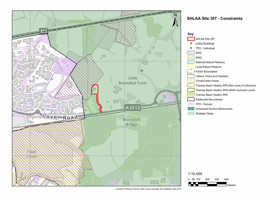
Nature Conservation Site is within the 5km Thames Basin Heaths SPA Zone of Influence. A site of this small scale is likely be within the capacity of the Hitches Lane SANG to mitigate its potential impact on the TBH SPA. If this proves not to be the case, contributions towards additional SANG provision should be required. There are no nature conservation constraints on the site, however, the Foxlease and Ancellʼs Meadows SSSI is just to the northwest of the site. In addition, the Sankey Lane Meadow SINC is in close proximity to the west side of the site and the Fleet Pond Woods SINC is south just beyond the railway line to the south. Any development at the site would need to take these nearby constraints into account.
Hart District Council Local Plan Site Assessment: Stage 2 – High Level Site Assessment – SHL357 – Land at Sankey lane, Fleet Confidential Draft - 1.1 – April 2015
Adams Hendry Consulting Ltd 3
Minerals Resources The Hampshire Minerals and Waste Plan Policies Map indicates that there are no areas within the site that are subject to minerals safeguarding.
Landscape HCC Integrated LCA (2012) Landscape type: Lowland mosaic heath associated Landscape character: Northeast Hampshire Plantations and Heath Hart District LCA 1997: Landscape type: patchwork of farmland, open heath, parkland and woodland Landscape Character Area: Minley Main features of the Minley LCA: The extensive open commons of Yateley and Hawley that are heavily used for recreation. The LCA has a suburbanised and fragmented character created by the intrusion of roads especially the M3 and A327. The wooded parkland landscape of Minley Manor is also contained within this LCA. Summary Assessment: The site is currently in use by a number of commercial units and has a variety of untidy buildings as well as a significant amount of surface car parking. The site has some existing tree screening to all sides, which will help to reduce visual impact into the surrounding countryside. However, given the current uses, it is not likely that re-development for housing would give rise to any worse landscape impact than are already caused by the existing uses. Indeed, there may be an opportunity to reduce visual intrusion and landscape impact through augmentation of the boundary tree screening and through careful design of any new development.
Agricultural Land This site is on land classified as ʻnon-agricultural landʼ.
Heritage Assets There are no heritage assets on or in close proximity to this site.
Water resources and quality
There are no Groundwater Source Protection Zones or licensed water abstraction points in close proximity to the site.
Air Quality There are not believed to be any Air Quality Management Areas in close proximity to the site. On the basis of evidence seen, there are no surrounding land uses considered to pose any risk to air quality.
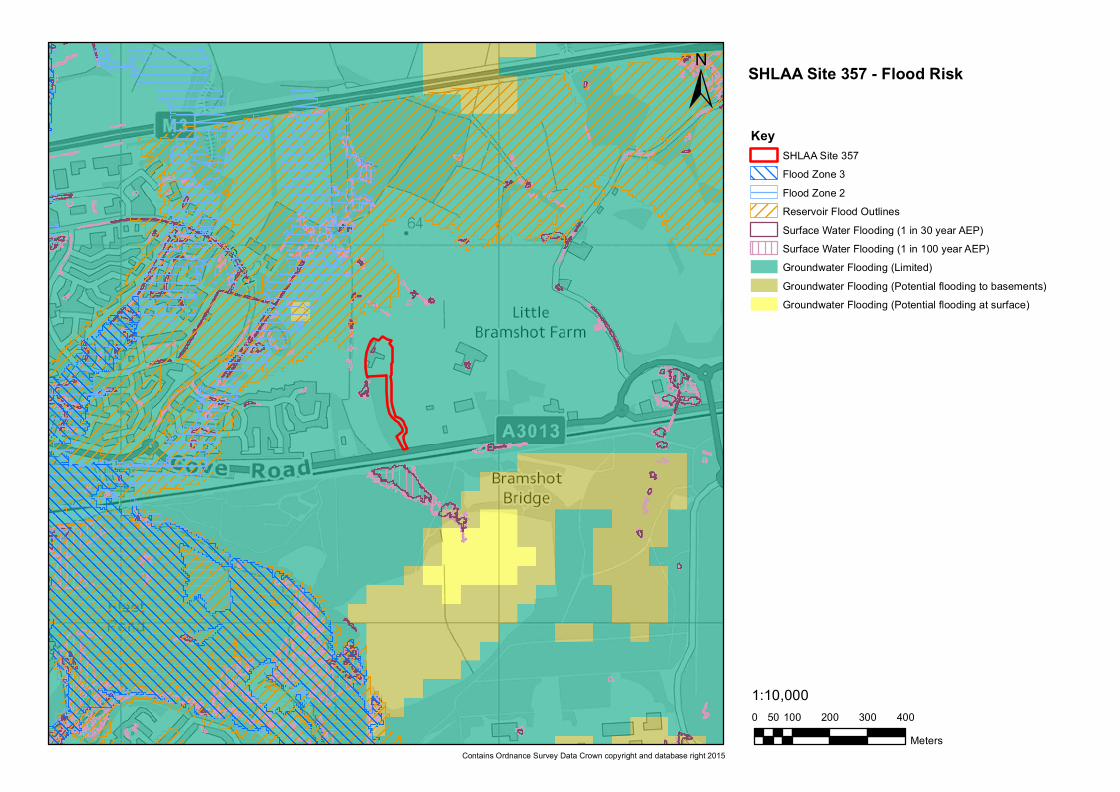
Flood risk The site is entirely within Flood Zone 1. A very small area within this site is indicated to be at risk from surface water flooding, although this is not considered likely to represent a constraint.
Hart District Council Local Plan Site Assessment: Stage 2 – High Level Site Assessment – SHL357 – Land at Sankey lane, Fleet Confidential Draft - 1.1 – April 2015
Adams Hendry Consulting Ltd 4
Location and scale of development
This is a small compact site isolated within the countryside to the north of the Fleet Road (A3013) between Elvetham Heath and Cove. The site is linked to the A3013 by a 300m driveway. The site is currently in commercial use and the entire site appears to be previously developed land. However, it is within the Fleet/Farnborough Strategic Gap. Nevertheless, given the existing relatively intensive uses on the site, it is not considered likely that redeveloping this site would give rise to any additional settlement coalescence between Fleet and Farnborough.
Un-neighbourly Uses
The land to the east, west and north of the site is ʻManaged Accessʼ MOD land used for military training purposes. This may involve the use of pyrotechnics blank ammunition firing and other loud noises. It would be necessary to engage with the MOD is this site were to be taken forward for redevelopment.
Availability Assessment
The site is believed to be available, although this would need to be confirmed with the landowner/site promoter.
Site Access
The site is likely to be accessed using the existing driveway onto the A3013 (Fleet Road). This part of the A3013 does not currently have any pavement infrastructure, and if the site were to be taken foreword, consideration would need to be made of how safe pedestrian access to the site could be achieved.
Summary of Constraints
• Infrastructure deficiencies have been identified which would need to be addressed. • The site is in close proximity to a number of significant nature conservation constraints. • Site is isolated within the countryside and within the Fleet/Farnborough Strategic Gap. • The site is adjacent to ʻManaged Accessʼ MOD land. • Safe pedestrian access to the site is not currently possible. • Site availability needs to be confirmed.
Summary of Opportunities
Assuming that the constraints can be overcome, this small previously developed site has the potential to provide for a limited number of new homes.
Focus of further assessment, should the site be shortlisted by the Council
• An assessment should be undertaken to determine whether redevelopment would harm the various nature conservation assets. • It would be necessary to engage with the MOD is this site were to be taken forward for redevelopment. • Consideration would need to be made of how safe pedestrian access to the site could be achieved. • Site availability needs to be confirmed.
Site Assessment Completed by
Name: PH Date: 16/04/2015
Hart District Council Local Plan Site Assessment: Stage 2 – High Level Site Assessment – SHL357 – Land at Sankey lane, Fleet Confidential Draft - 1.1 – April 2015
Adams Hendry Consulting Ltd 5
HDC Conclusion and recommendation
Shortlist the site:
Do not shortlist the site:
HDC Comments:
0 100 200 300 40050Meters
1:10,000
±Key
SHLAA Site 357Listed Buildings
! TPO - IndividualSSSISINCNational Nature ReserveLocal Nature ReserveParish BoundariesHistoric Parks and GardensConservation AreasThames Basin Heaths SPA (5km zone of influence)Thames Basin Heaths SPA (400m exclusion zone)Thames Basin Heaths SPASettlement BoundariesTPO - GroupsScheduled Ancient MonumentsStrategic Gaps
Contains Ordnance Survey Data Crown copyright and database right 2015
SHLAA Site 357 - Constraints
0 100 200 300 40050Meters
1:10,000
±Key
SHLAA Site 357Flood Zone 3Flood Zone 2Reservoir Flood OutlinesSurface Water Flooding (1 in 30 year AEP)Surface Water Flooding (1 in 100 year AEP)Groundwater Flooding (Limited)Groundwater Flooding (Potential flooding to basements)Groundwater Flooding (Potential flooding at surface)
Contains Ordnance Survey Data Crown copyright and database right 2015
SHLAA Site 357 - Flood Risk