Embed Size (px)
Citation preview
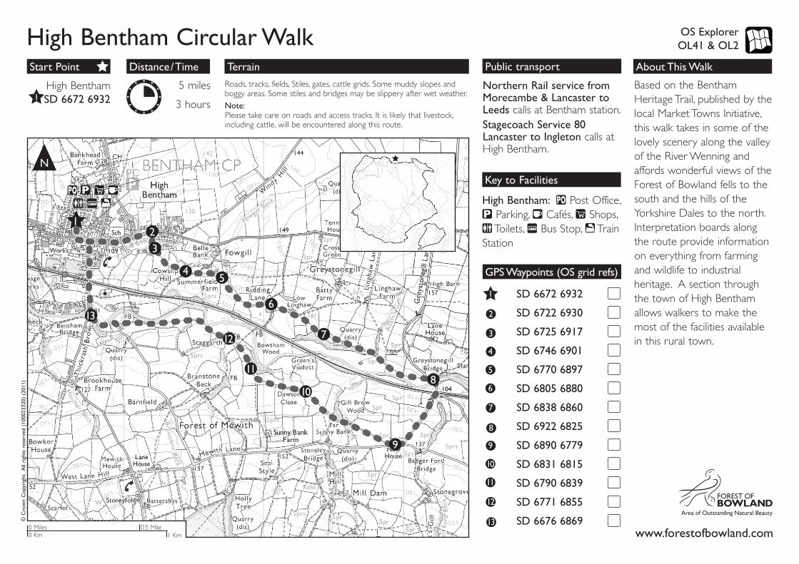
Public transport
OS Explorer OL41 & OL2
TerrainDistance/TimeStart Point
Key to Facilities
About This Walk
High Bentham Circular Walk©
Cro
wn
Cop
yrig
ht.
All
righ
ts r
eser
ved
(100
0233
20)
(201
1)
N
High Bentham: Post Office, Parking, Cafés, Shops, Toilets, Bus Stop, Train
Station
Northern Rail service from Morecambe & Lancaster to Leeds calls at Bentham station.Stagecoach Service 80 Lancaster to Ingleton calls at High Bentham.
Roads, tracks, fields, Stiles, gates, cattle grids. Some muddy slopes and boggy areas. Some stiles and bridges may be slippery after wet weather.
Note:Please take care on roads and access tracks. It is likely that livestock, including cattle, will be encountered along this route.
5 miles
3 hours
High Bentham SD 6672 6932
GPS Waypoints (OS grid refs)
3
4
9
5
10
6
11
1
2
7
12
SD 6672 6932
SD 6722 6930
SD 6725 6917
SD 6746 6901
SD 6770 6897
SD 6805 6880
SD 6838 6860
SD 6922 6825
SD 6890 6779
SD 6831 6815
SD 6790 6839
SD 6771 6855
SD 6676 6869
8
13
12
3
45
6
7
8
9
10
11
12
13
0.5 Mile0 Miles0 Km 1 Km
1
www.forestofbowland.com
Based on the Bentham Heritage Trail, published by the local Market Towns Initiative, this walk takes in some of the lovely scenery along the valley of the River Wenning and affords wonderful views of the Forest of Bowland fells to the south and the hills of the Yorkshire Dales to the north. Interpretation boards along the route provide information on everything from farming and wildlife to industrial heritage. A section through the town of High Bentham allows walkers to make the most of the facilities available in this rural town.
Walk Description
the field and go through the gated stile in the field corner. Continue along to join the field track then through the field gate to bear slightly left and over the stile in the next wall. Bear slightly right as you cross this field to go over the stone step stile in the wall. Bear slightly left as you cross the next field to reach the stile onto the road.
GPS: SD 6922 6825On joining the road turn right and follow the road over the river and the railway then uphill and at the T-junction turn right.
GPS: SD 6890 6779Take the first footpath on the right, just past New House, and follow the right hand field boundary until you reach the stone stile. Cross the stile and go down the short slope to cross the footbridge over the stream then follow the path to the stile in the next wall. Go through the stile and across the field to the gate in the next boundary. Cross this field and go through the stone V-stile.
GPS: SD 6831 6815Take the path ahead, past the ruined building on the left and follow the field edge to go through the gated stile. Continue ahead, first along the field boundary, then bearing right across the
field to meet the woodland edge which you follow to the next boundary. (Take care where the field edge is eroding in places here).
GPS: SD 6790 6839Cross the stone stile and follow the grass track down to the buildings ahead. Climb the stile and follow the footpath between the farm buildings.
GPS: SD 6771 6855Just before the end of the last building on the left, go through the field entrance on the right hand side and bear diagonally left across the caravan field, through the metal kissing gate and follow the path keeping the river on your right. Just before the next boundary, turn left along the wall-side and go through the gate in the corner of the field. Head across the middle of the field to the next boundary. Go over the stone stile and across the field to go through the gap in the wall then follow the field edge to the road. On reaching the road turn right and follow it to the junction with Thickrash Brow road.
GPS: SD 6676 6869Turn right and follow this road back up into the middle of High Bentham. (Note that this road is without pavement in some sections).
GPS: SD 6672 6932From the top end of the car park, follow the sign to the Coach House pub and through on to the main street (B6480). Cross over and continue left along the main road, heading out of the main part of the town, until reaching the first footpath on the right.
GPS: SD 6722 6930Take the right hand of the two tracks (over the cattle grid) and on reaching an area of open land climb the stone stile in the wall on the left. Cross the drive to go through the waymarked gap opposite and turn right to follow the grass track.
GPS: SD 6725 6917Climb the stile at the end of the track and bear diagonally left across the field and down the hill then over the wooden sleeper bridge. (Take care of gaps in planking). Follow the left hand field edge round to the stile in the corner of the wall. Once over the stile, bear left up hill to a gated stone stile and onto a narrow track.
GPS: SD 6746 6901Turn left and follow the track for a short distance. Just as the track bends to the left, go through the stile ahead, across the field and through the gate at
the far side. Bear slightly right down the slope and through the gate at the end of the wall.
GPS: SD 6770 6897Contour round the slope and over the stone stile in the next boundary. Bear slightly right across the field and through the gate in the next boundary. Walk across the field past the farm building (on the right).
GPS: SD 6805 6880At the interpretation board go into the yard and turn immediately left then bear right through the farm gateway to pass in front of the house. Go through the next gate and follow the track, keeping right at the fork, and through the next gate. (Take care around the slurry pit to the left as you go through this gate). Walk past the farm buildings on the left and at the next field boundary go through the gate. Bear slightly right across the field to cross the stile in the next boundary then bear diagonally right to the gate near the corner of this field.
GPS: SD 6838 6860Go through the gate and bear left to the far corner of the field. Go over the stile and keep straight on with the woodland edge on your right to cross
1
High Bentham Circular Walk
2
3
4
5
6
10
11
12
137
8
9


![Ol41-6588 ' .~ , , - Digital Himalaya: Homehimalaya.socanth.cam.ac.uk/collections/journals/chowkidar/pdf/... · Sit Jolin '.CPl,ton. ICCMG. OB[ Mr'. ] ,.1:. l{i. ... job it, be the](https://img.pdfslide.us/doc/110x75/5cc289dc88c99315158e0202/ol41-6588-digital-himalaya-sit-jolin-cplton-iccmg-ob-mr.jpg)