Embed Size (px)
Citation preview
Hidden Maps, Hidden City: The Jamestown Connection To The Lost Colony
By Fred Willard And Phillip McMullan
Research Assistant Kathryn Sugg
DRAFT COPY AUGUST 18, 2012
7/25/2013
Requirement for a Multidiscipline Study Degree on Coastal Carolina Indians
for Dr. James Kirkland and Dr. Karen Mulchaey
1
HIDDEN MAPS, HIDDEN CITY:
THE JAMESTOWN CONNECTION TO THE LOST COLONY
By
Fred Willard and Philip McMullan
Research Assistant Kathryn Sugg
Dedication
The research and findings presented in the below work is a collaboration of many years
of dedication with many people, and all by volunteers, receiving only expenses in most cases.
However, several people have made very significant contributions, and deserve to be singled out.
This research and collaboration of many individuals has resulted in the formalization of the Lost
Colony Center for Science and Research, Inc., now located in Williamston, North Carolina, with
field stations in East Lake, Dare County, and in Gumneck, Tyrell County, where most of the
book- and map-learned research is being ground-proofed today.
Recognition and thanks need to go the originators of the research center, and its humble
beginnings, which were located in Buxton, North Carolina, in the Outer Banks. The group’s
origins started as the Croatan Group, which was founded by Fred Willard (one of the co-authors
of this paper), Barbara Midgette, G.G. Rosell, and Mr. and Mrs. Bornfriend. It was formed to
facilitate a very important partnership with the eminent archaeologist, Dr. David Phelps, East
Carolina University Director of the Archaeology Department. The formalization of a plan for
research, excavation, and archaeological examination of the proffered site of the Croatan Indians
has become widely-known as the Croatan Project.
All of the above people certainly deserve recognition for the most important discovery in
the last 400 years, as to the possible fate of the 1587 “Lost Colony”. This certainly was a major
achievement, but the future stage was set for even more important research, based on the
hypothesis that, in all likelihood, the colony did not disappear, but simply went native and were
2
completely assimilated into coastal North Carolina Indian cultures. With the realization that this
merger of cultures did in fact most likely take place, it became evident that the way to find the
mysterious Lost Colony was to follow and track the movements of the colonists’ best friends, the
Croatan Indians. And it was about this time that a Native American researcher by the name of
Charles Shepherd called the Archaeology Department at East Carolina University, and was
referred to the Croatan Group, who has since then renamed themselves the Lost Colony Center
for Science & Research, Inc.
Charles Shepherd is of an African-American and Native American mixed culture, who
may possibly share genes with members of the 1587 colony himself. Having dealt with hundreds
of people interested in these stories, including academic researchers, Charles is one of the most-
focused researchers relating to the coastal Indians of North Carolina, and for fifteen years has
dedicated thousands of hours partnering with the Lost Colony Center preparing its research
design, which has recently received partial credit for a major paradigm shift in the thinking of
what happened to the Lost Colony.
Many scholars proffered that the colony migrated to Chesapeake Bay and were murdered
by Pocahontas’ father, the great Chief Powhatan. Today, the consensus of all research indicates
that this is no longer the number one considered theory, and that the old paradigm has been
overturned with the new theory: an enculturation process between the 1587 colony and coastal
Indians likely did take place, and the Croatan Indians were catapulted to coastal prominence as a
result, replacing the once-very-powerful Secotan Confederation. Although depicted on many
maps after that period, the Secotan seemingly ceased to exist, although in all probability they
were just assimilated. The English and Croatan alliance showed other Native Americans how to
merge back into the new political environment. Everybody working with the original Croatan

3
Group, now the much-larger Lost Colony Center for Science & Research, Inc., all owe a
tremendous gratitude to the self-proclaimed Mattamuskeet Indian, Charles “Sweet-Water
Medicine” Shepherd (see photograph below).
4
Introduction
“The Roanoke voyages and colonizing experiments of the years
1584 to 1590 were the first to bring English men, women, and
children to settle in any part of North America. Although these
attempts failed, they lie at the very roots of English experience in
North America and the beginnings of what was to become the
thirteen colonies and the United States.”1 1
In a “well-known” story, Sir Walter Raleigh’s attempt to settle ‘Virginia’ in 1587 became
‘The Lost Colony’; 117 men, women and children simply disappeared. John White, the
Colony’s governor, described how the colonists were forced to remain on Roanoke Island when
their intended destination was Chesapeake Bay. There they were abandoned and became lost to
history because the Spanish Armada was about to sail, and Queen Elizabeth caused their
resupply ships to be diverted. However, significant evidence suggests that they intentionally
relocated inland and that Raleigh, at least, and his investors kept in touch with them. The colony
continued the alliance they had formed with the Croatan Indians and, for at least ten more years,
supplied Raleigh with a valuable secret commodity - sassafras. They chose Beechland, a
protected sassafras site about 50 miles into the mainland, in order to prevent the Spaniards (and
potential competitors) from finding them (see Clue #23 in Appendix, the “smoking gun” clue).
This profitable venture ended after Raleigh was arrested for treason and consequently lost
his patent and his head after the death of Queen Elizabeth. In this theoretical scenario, the so-
called ‘Lost Colonists’ were not lost, but were abandoned when Raleigh could no longer send
ships to them after 1618. An ever-accumulating amount of evidence for the colonists’ movement
has been recently found, regarding Beechland as their final destination, from multiple sources:
original accounts, native alliances, oral histories, naming patterns, archeological artifacts,
1 David B. Quinn and Allison M. Quinn, eds., The First Colonists: Document on the Planning of the First English
Settlements in North America 1584-1590 (Raleigh: North Carolina Department of Cultural Resources, Division of
Archives and History, 1982), iii.
5
reanalysis of certain early maps, and the recent discovery of two more early maps relating to the
1587 colony. A thorough archeological investigation of the Beechland area might yield the
crucial clues to resolve the longstanding mystery of what became of the Lost Colony. The
proffered theory that the Lost Colony “went native” was not highly considered by early scholars;
however, it is now the number one paradigm accepted by most researchers.
According to the histories of seventeenth-century North Carolina, the coastal Native
Americans, found at the time of European contact, ceased to exist as an identifiable, political
group by approximately 1690. In 1701-09, John Lawson visited the famous Croatan Indians (by
this time they were called Hatteras Indians). He noted light hair and blue eyes and their affection
for the English, stating they had ancestors whom could “speak from the book”2.2 The last
recorded mention of these coastal Indians was in 1729 by the Surveyor General of North
Carolina, Edward Mosley: “There are no Indians living on the coast but seven or eight Hatteras
Indians living at Indian Town, with the English”33(present Cape Point and King’s Creek on the
Outer Banks in what is now called Buxton, and the villages are located on the sound sides). The
Croatan Indians, as a group, from this point forward are reported to have disappeared off of the
face of the earth.
This well-documented scenario may not be the case about one of the most famous Indian
tribes of North America. “Croatoan” is the enciphered message left on the tree for John White,
the governor of the 1587 “Lost Colony”, indicating where the colony could be found. This site
2 John D. Lawson, A New Voyage To Carolina, edited with an Introduction and Notes by Hugh Talmage Lefler
(Chapel Hill: University of North Carolina Press), reprint edition 1967. Original title & publication: A New Voyage
to Carolina; Containing the Exact Description and Natural History of That Country: Together with the Present
State Thereof. And a Journal of a Thousand Miles, Travel'd Thro' Several Nations of Indians. Giving a Particular
Account of Their Customs, Manners, &c., London: [s.n.], 1709. Lawson also noted that the Hatteras Indians
dressed more like Europeans than Natives, with linen shirts and long stockings.
3 The Moseley Map of 1729-33, where this information and quote came from, can be found in the Special
Collections Department of East Carolina University’s Joyner Library.
6
was discovered and excavated by the Croatan Group (now the Lost Colony Center for Science &
Research, Inc.) in partnership with Dr. David Phelps44in the mid-1980s, where some of the most
significant early English artifacts ever found in North America were uncovered5.5 The research
done since then has elevated anticipation and excitement about these lost English colonists in the
wilderness, and their probable eventual fate of going native. As a result, this story is now widely
reported as the most exciting and important unsolved mystery in North America. Furthermore,
when the story has been pieced together, it will possibly become a compelling screenplay to rival
the Pocahontas story.
The works presented below are intended to proffer that the New City of Raleigh, which
was founded in 1587 by Sir Walter Raleigh and John White as Governor, was located between
the Indian villages of Pomeyooc and Tramanskecooc (50 miles inland), as depicted on the
original John White Manuscript Maps A and B (see page numbers 13 and 22 below). This places
the Lost Colony of 1587 in the area of Engelhard, North Carolina and the Alligator River today.
Four mapmakers over a 65-year period all gave parts of the information as to where the
Lost Colony of 1587 was located. It is only when their maps and their correlating information
are compared together that the location of the Lost Colony (i.e. the new city of Raleigh) might be
determined. The co-authors of this paper have shown through maps where the colonists known
to Jamestown leaders were expected to be located, and furthermore, the information garnered has
strong indications that contact was made in the 1607-1609 period.
4 Dr. Phelps was the director of the archaeological department of East Carolina University at the time. 5 Details can be found on the website www.lost-colony.com: Jim Morrison, “In Search of the Lost Colony”,
American Archaeology, Vol. 10, No. 4 (Maryland: Archaeological Conservancy Quarterly Publication (Eastern
Region)), Winter 2006-2007: 38-44, http://lost-colony.com/magazineAA.html, and Catherine Kozak Virginian-
Pilot (Hampton Roads, VA) articles: “Buxton Crew Digs Up Possible Lost Colony Link” 10/14/98; “New Hints to
Lost Colonists Found” 3/31/01; “Paper Linking Croatan Indians, the Lost Colony Garners Awards” 4/29/03; “Old
Account May Yield New Clues to Lost Colony” 2/3/05; “ECSU (Elizabeth City State University) Researchers Go
High-Tech in Old Search” 3/6/05; “Team Plans to Resurrect Excavations at Croatan Site” 11/1/05; “At 75, Historian
Still Hits the Books in College” 6/5/06; “Seeking the Lost Colony” 7/2/06; “Team Hopes DNA is Clue to Lost
Colony Mystery” 6/11/07.
7
The map findings below can be reviewed more thoroughly and in-depth from the website
http://www.lost-colony.com/currentresearch.html6.6 In addition, a new interpretation of the
Zuniga Map and the support of the Percy Map7 has provided compelling evidence for the co-
authors’ hypothesis8 that the location is between Engelhard and the Alligator River floodplain.
This paper’s major purpose is to show convincingly that colonists from the 1587 voyage
were alive and contacted in 1607-1609, and that the co-authors’ hypothesis predicts their new
settlement location is in Beechland today. The co-authors have found new evidence of the
colonists’ location through a re-examination of maps that were prepared between 1587 and 1651.
These maps are John White’s 1585 Manuscript Maps A and B, the Zuniga map c1609, the Percy
map c1609, and the John Farrar Map of 16519. When examined together, and transparency
overlays are made, these maps show that, in 1608, there were men in English clothing near the
bend in the Alligator River four miles west of the Indian village of Pomeyooc, where sassafras
was indicated on the Farrar Map. This new evidence firmly locates the colonists where the co-
authors’ hypothesis places them in 1587, in all of the research papers cited in Footnote 6 below.
6 Please refer to the following research papers and material at http://www.lost-colony.com/currentresearch.html:
Philip McMullan, “A Role for Sassafras in the Search for the Lost Colony”(Lost Colony Center for Science and
Research), 2006; Fred L. Willard, “The Machapungo Indians and the Barbados Connection: 1663 to 1840” (East
Carolina University History Department: Dr. Angela Thompson - Directed Studies in History), 2008; Philip
McMullan, “A Search For The Lost Colony In Beechland” (Northeastern NC Development), 2002; Phil
McMullan, “Beechland & The Lost Colony” (North Carolina State University History Department: Dr. Holly
Brewer (A thesis submitted to the Graduate Faculty of in partial fulfillment of the requirements for the Degree of
Master of Arts)), 2010; Fred L. Willard, “Migration Patterns of Coastal N.C. Indians” (East Carolina University: An
independent study in English as a requirement for the East Carolina University Honors Program combined with an
Interdisciplinary Minor on the study of “The 1587 Lost Colony”), 1998; Fred L. Willard, “A Reassessment of the
Zuniga Map” (East Carolina University History Department: Dr. Christopher Oakley - Problems in North Carolina
History), 2008; and “Elizabeth City State University 2005 Research” Lost Colony and Remote-Sensing Team with
archaeologists Dr. Anne Garland, Dr. Francisco San Juan & Dr. Palipin of Missouri University: Croatan, Buck
Ridge, and Goshen Ridge).
7 The author of this map has not been definitely confirmed as of this date, but one of the map researchers has
tentative identified Sir George Percy’s handwriting on the map. More probably, the author is Nathan Powell (see P.
10). H. P. Kraus, Monumenta Cartographica, cat. 124, no. 28 (1969), pp. 43-6. The map legend reads: No. 28
VIRGINIA Manuscript map (Virginia c1610) (Greatly reduced from 470 x 635 mm); Quinn, 1955.
8 Dr. Ralph Scott, Personal Communication, May 2012; Dr. David LaVere, Personal Communication, July 2012
9 It should be noted that although this map was drawn some 60 years after the original John White map, its etiology
actually originates in a book that possibly came from Thomas Harriot’s original work (see p. 12-13 of that book).
8
The Zuniga Map
On September 10, 1608, King Phillip III (of Spain) received intelligence from the
London spy network of Pedro de Zuniga. Contained in a packet from Zuniga was a tracing of a
map (the person is described by Zuniga as an Englishman, probably Captain Francis Nelson) sent
home to England from John Smith in Virginia (see Footnote 12 and Fig. 1 for details). This
document gave intelligence that Panawicke (possibly now located near Engelhard, North
Carolina), Pakercanick (possibly in Pamlico County, North Carolina) and Ohanhowan (possibly
on the Roanoke River) were all locations where colonists from Roanoke Island were now
residing with Indians, probably as captive slaves.
Historian David Beers Quinn wrote: “Clearly the Zuniga map is of the greatest
importance in showing us what was known and surmised in 1608 as to the area south of the
James (River)10.”7 Alexander Brown first published the Zuniga map in America in Genesis of the
United States in 189011.8 Brown wrote that the map was a rough drawing sent by Francis Nelson
from Virginia, in 1608, to illustrate Captain John Smith’s True Relation12.9 The Zuniga Map was
purloined from London and sent to Spain that same year by Spanish Ambassador Pedro de
Zuniga13. It remained undisturbed in the Spanish archives for the next three centuries.
David Beers Quinn asserts that on the expedition to find the Lost Colony in 1607, with
the chief of the Paspahegh Indians, and although two English men started out with him, but the
chief turned back. The English men, however, did go much further south. A report on this
10 David Beers Quinn, England and the Discovery of America 1481-1620 (London: George Allen and Unwin, Ltd.),
1974: 461.
11 Alexander Brown, Genesis of the United States (Boston, New York: Houghton, Mifflin, and Co.), 1890.
12 John Smith, A True Relation of Such Occurrences and Accidents of Note as Hath Hapned in Virginia Since
the First Planting of that Colony, which is now resident in the South part thereof, till the last returne from
thence. Written by Captaine Smith, one of the said Collony, to a worshipfull friend of his in England. London:
Printed for John Tappe, and are to bee solde at the Greyhound in Paules-Church yard, by W.W. 1608.
13 Brown, Genesis of the United States, Vol. 2, 1890: 1067-8.
9
expedition, which has not survived, was sent to London, and was the basis for more orders given
by the Royal Council for Virginia in May 1609 to make further contact14.
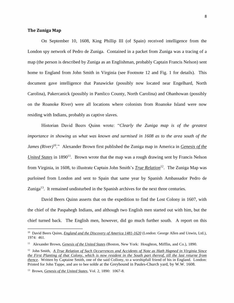
Fig. 1 - The Original Zuniga Map of Virginia
The complete Zuniga map, as discovered in the Spanish archives, is shown in Figure
115.10 Alexander Brown cropped the segment within the dashed lines on Figure 1 and turned the
map 45 degrees, to place the James River to the north. The resulting map in Figure 2 shows the
scribbled notes that historians (with many other maps) have attempted to decipher for the past
100 years. Alexander Brown’s interpretation attempts of the scribbled notes are presented in
Figure 3. Many other historians, such as David Beers Quinn, Philip Barbour, James Horn16, Lee
Miller and Thomas Parramore have attempted an interpretation, but there has been no agreement
about the locations of the three groups of Englishmen that the map suggests were survivors of the
1587 colony. The co-authors of this paper, however, are in agreement with Quinn and Barbour,
but not with Parramore, Horn and Miller.
14 David Beers Quinn, Set Fair For Roanoke: Voyages and Colonies, 1584-1606 (Chapel Hill: University of
North Carolina Press, America’s 400th Anniversary Committee), 1985: 370-1. 15 The original map is in the Archivo General de Simancas, M.P.D., IV-66, XIX-153; reproduced in Barbour, The Jamestown Voyages Under the First Charter, 1606-1609, Vol. I (Cambridge: Cambridge University Press), 1969,
facing p. 238 and James Horn, A Kingdom Strange (New York: Basic Books), 2010: 212. 16 Horn, 2010: 228-230. Horn has interpreted the Zuniga map, placing Panawicki on Salmon Creek, and
Pakerakanic at the head of the Tar River. The map work did not take into account that Pakerakanic has been placed
on the Neuse River by every other authority researching it for the last 100 years. And Ocanahonan, clearly shown on
the Zuniga map, is in a totally different body of water (the Roanoke River) and location than Panawicki, located
halfway between the Pamlico River and the Chowan---clearly not on Salmon Creek (see Percy and Zuniga overlays).
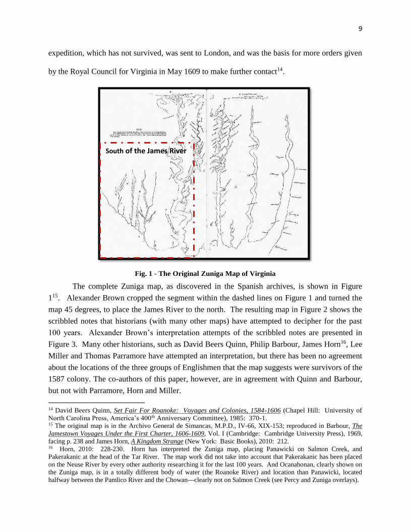
South of the James River
10
Fig. 2 - Zuniga Map South of the James River
The Albemarle Sound is clearly discernible just south of the James River, extending to the west into the
coastal plain of what is now North Carolina. In addition, the Pamlico River also extends to the west, and is just
below the Albemarle Sound. Halfway between these two, extending (although the scale is imperfect) is the most
important notation on this map, and is denoted as “Pananiok”, and has been indicated by many sources as the
location of many of Sir Water Raleigh’s colony. The actual spelling of this site, as designated on approximately
twenty maps and specifically on the John White 1585 Manuscript A map, is “Pomeyooc” (for many of the clues and
citations, see “Clues” in the Appendix). Many interpretations of this location have been made by scholars over the
past hundred years. It is not until this map is compared with the Farrar and Percy Maps, a transparency rescaled to
the John White map, and a modern map of North Carolina, that the exact shoreline at the Pananiok location is shown
to match the shoreline on the John White map. More importantly, it is in close proximity to Pomeyooc and extends
inland, and seems to terminate at the village site on the White map named “Tramanskecooc”. When the White and
Zuniga maps are compared with the Farrar map, the sassafras tree is depicted in the same area of Tramanskecooc on
the White map, despite certain river orientation eschewment on every map drawn prior to the Percy map.
It is important, when logically researching locations, that discoveries are confirmed from multiple sources.
In the referenced material above, the authors of this paper have just discovered that the Percy Map of 1607 (see
below) seems to confirm both of the Indian sites of Tramanskecooc and Pomeyooc. This added information
proffered from the Percy map has also given strong evidence that contact with the Lost Colony was achieved by
whoever drew this map (indications are it may have been Nathan Powell, a cartographer who accompanied Smith on
his Chesapeake Bay adventures)17.11
The above assumption about contact being made is clearly inexplicable,
because the Albemarle and Pamlico River orientations to the coast are misaligned and eschewed, but they are
aligned when the scales of the two maps are justified (by increasing the Percy map location of the Pamlico and
Albemarle to match a modern-day map of North Carolina). When this is accomplished, the two black dots
(embellished to red) on the Percy map below are in very close proximity on the modern map to Engelhard, North
Carolina and the headwaters of the Alligator River---as depicted on both the White and Farrar maps as where
sassafras and the Indian village of Tramansquecooc were found. It must be noted that this Indian village
mysteriously disappeared on all future maps after the publication of Thomas Harriot’s Brief & True Report, where
he for the first time announces that secrets commodities in a secret location have been found, but because of
“welwillers not to the good of the action” (people who would steal the secrets), the location will be withheld.
17 William P. Cummings, The Southeast In Early Maps (Chapel Hill: University of North Carolina Press), 1998:
136-137, citing Clifford M. Lewis & Albert J. Loomie, The Spanish Jesuit Mission in Virginia, 1570-1572 (Chapel
Hill: University of North Carolina Press), 1953: 262-263.
James River
11
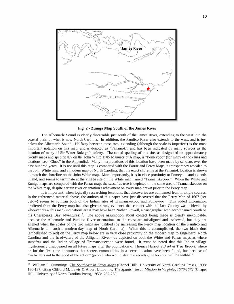
Fig. 3 - Alexander Brown’s Interpretation of the of Zuniga Map
The scribble sentences on the Zuniga map are clearly related to sentences in John Smith’s
True Relation. Captain Smith wrote in True Relation that Opechancanough, the brother of Chief
Powhatan, told him “of certain men cloathed at a place called Ocanahona, clothed like me.”
Most map interpreters agree that Ocanahonan [A] was on Roanoke River, despite ‘Morattac’ [B]
being relocated on the river to the south, but near the mouth of the Roanoke River, as depicted on
most earlier maps. The map also states, “Here remayneth 4 men clothed that came from
Roonock to Ochanahowan18”12above the word “Pakrakwich”, on what is generally assumed to be
18 Lee Miller, Roanoke: Solving The Mystery Of The Lost Colony (New York: Arcade Publishing), 2000: 245-53.
“Ocanahowan” is Siouan for “many people gather here”; the Algonquian equivalent is “Occaneechi”.
A
B
D
C
E
12
the Neuse River [C]. Smith also wrote, “We agreed with the king of Paspahegh to conduct two
of our men to a place called Panawicke, beyond Roonok, where he reported many men to be
appareled.” A very similar statement - “Here Paspahegh and two of our men landed to go to
Pananiock” - appears on the map below the James River [D].
One purpose of this paper is to identify the region immediately west of the island of
“Roonok” where the word “Pananiock” is written [E]. Under Pananiock on the map, Brown has
written: “Here the King of Paspahegh reported our men to be and want to go.” Others have
interpreted this to say: “Here the King of Paspahegh reported our men to be and went to se19.”13
It is this location and this statement that is of most interest to the authors’ hypothesis. If
Pananiock can be shown to be John White’s village of Pomeyooc, and if that is where “the King
of Paspahegh reported our men to be,” this would provide significant support to the co-authors’
hypothesis. That proof would be the key to unlocking the interpretation of all other parts of the
map - and the location of the 1587 colonists in 1608. It is also reported at this site
(Pananiok/Pomeyooc, see Letter “E” in Figure 3 above) there is a large store of salt stones20.
19 Miller, 2000: 246; Quinn, 1974: 460; Barbour, 1969: 190. These authors all agree with this particular
interpretation, supporting the theory that the Zuniga and Percy maps were drawn by a person who was at the Indian
village of Pananiock (Pomeyooc) in 1607-1608.
20 Miller, 2000: 259. This information is noteworthy because it is the only one of the Indian villages previously
targeted by scholars that is close enough to the coast to produce salt. The upper Pamlico or Chowanoc (cited by
many authors as being the location of Pananiok on the Zuniga map) are locations with fresh water, ergo no salt
stones could have be made there (see “Chief Eyanoco” in Appendix). This would serve to eliminate Salmon Creek
or the Tar River west of Washington, NC as the location of Pananiock (Panawiki or Pomeyooc) as proffered by
Thomas Parramore.
A
13
Fig. 4 - John White’s 1585 Manuscript Map B
John White’s 1585 Manuscript Map B of Virginia is shown in Figure 4. The text and
arrows show where two of the inscriptions on the Zuniga map would be located on John White’s
map, if the co-authors’ interpretation is correct. Their hypothesis states that the colonists, on
Raleigh’s instruction, traveled by water with the Croatan to the lower end of the Alligator River,
where they found sassafras near the village of Tramanskecooc21.14 The red line shows the route
21 The John White Map of Eastern North America, as noted by Paul Hulton of the British Museum, indicates two
Indian village locations on the east side of the Alligator River named Tramanskecooc (which are not discernible
except on the original), one at the river’s edge and another somewhat inland (Paul Hulton, America 1585: The
Complete Drawings of John White (Chapel Hill: University of North Carolina Press), 1984: 85). The location of
this village correlates with four other unexplainable notations and maps (see Zuniga, Percy, Farrar, and White-
DeBry map figures throughout this paper) where it is either relocated or missing entirely (White-DeBry map, 1588,
in Brief & True Report) when the secret commodity discovery is announced.
“Men depart with King Paspahegh to find the men at Pananiock” Route of the colonists from Roanoke Island to “50 miles into the main.” The actual measured water route to the red dot is 49.9 miles. Destination Tramanskecooc Pomeyooc is almost assuredly Pananiock on the Zuniga map “where the King of Paspahegh reported our men to be & went to
se.”
14
they would have most likely taken from Roanoke Island to their destination. The lowest legend
states the co-authors’ belief that Pomeyooc is Pananiock, “where the King of Paspahege reported
our men to be and went to se (see Footnote 19).”
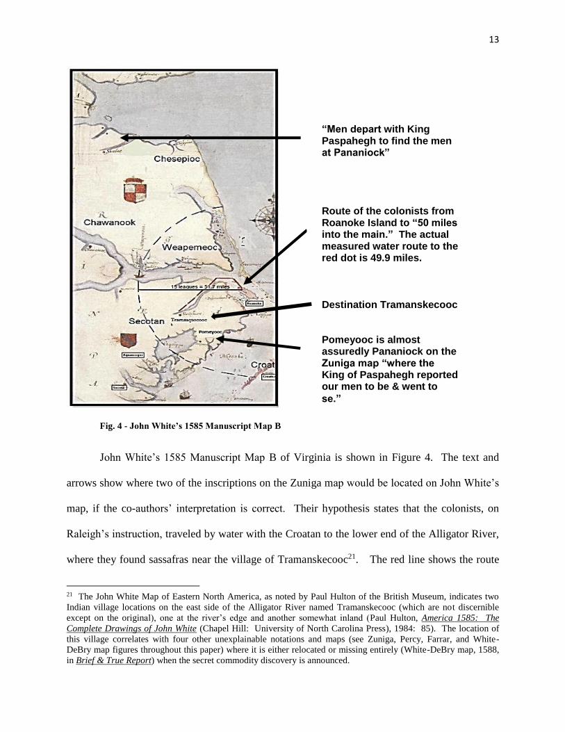
One of the earliest and most significant clues discovered relating to deliberate
misinformation and conspiracy was the disappearance of Tramanskecooc village in the
headwaters of the Alligator River on all future maps after 1585. The importance of this clue only
became relevant after the discovery of how many times this area was seemingly mentioned in
abundance of other clues relating to the disappearance of the Lost Colony (see Harriot quote &
Footnote 34, p. 19) and secret commodities in secret locations.
Fig. 5 – White-DeBry Map Segment On The Left Compared to Zuniga Map Segment On The Right
Although the Zuniga map is much cruder, its comparison in Figure 5 to the White-DeBry
map also showed similarities in the shapes of the region in which Pomeyooc/Pananiock is
located on the two maps.
Pomeyooc/Pananiock
15
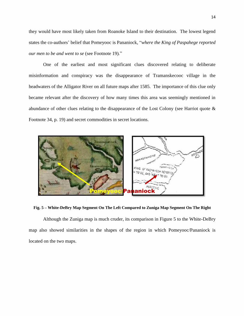
Fig. 6 - John White’s Map Segment On The Left Compared to Zuniga Map Segment On The Right
The co-authors then compared the White and Zuniga maps in Figure 6, and this
comparison also showed similarities. This suggests that both maps depict the peninsula between
the Albemarle and Pamlico sounds. For the two to be so similar, it is probable that the person
who drew the Zuniga map must have had access to the White maps when he drew the area shown
in the segment in Figure 6. 15
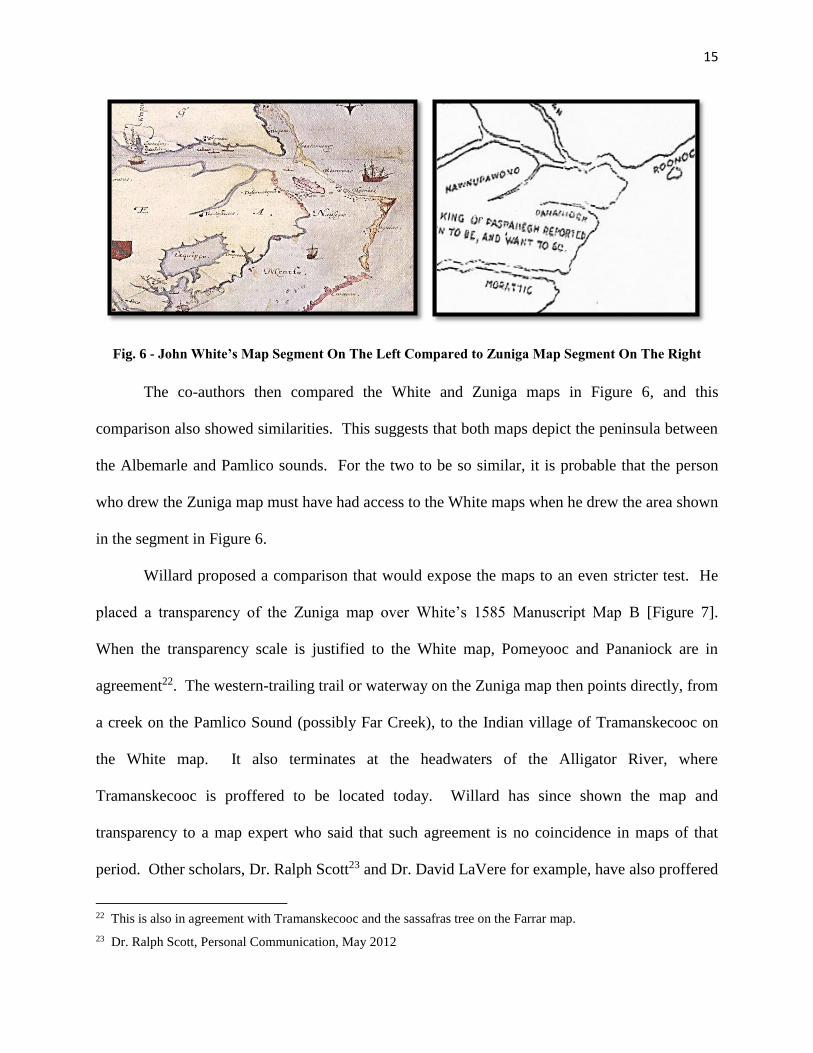
Willard proposed a comparison that would expose the maps to an even stricter test. He
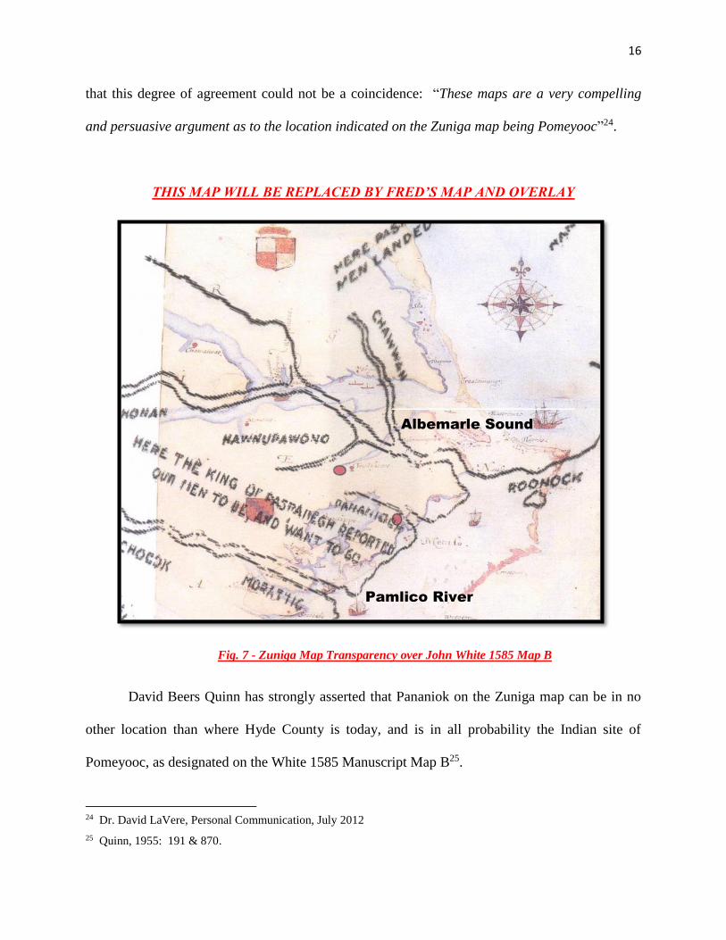
placed a transparency of the Zuniga map over White’s 1585 Manuscript Map B [Figure 7].
When the transparency scale is justified to the White map, Pomeyooc and Pananiock are in
agreement22. The western-trailing trail or waterway on the Zuniga map then points directly, from
a creek on the Pamlico Sound (possibly Far Creek), to the Indian village of Tramanskecooc on
the White map. It also terminates at the headwaters of the Alligator River, where
Tramanskecooc is proffered to be located today. Willard has since shown the map and
transparency to a map expert who said that such agreement is no coincidence in maps of that
period. Other scholars, Dr. Ralph Scott23 and Dr. David LaVere for example, have also proffered
22 This is also in agreement with Tramanskecooc and the sassafras tree on the Farrar map.
23 Dr. Ralph Scott, Personal Communication, May 2012
16
that this degree of agreement could not be a coincidence: “These maps are a very compelling
and persuasive argument as to the location indicated on the Zuniga map being Pomeyooc”24.
THIS MAP WILL BE REPLACED BY FRED’S MAP AND OVERLAY
Fig. 7 - Zuniga Map Transparency over John White 1585 Map B
David Beers Quinn has strongly asserted that Pananiok on the Zuniga map can be in no
other location than where Hyde County is today, and is in all probability the Indian site of
Pomeyooc, as designated on the White 1585 Manuscript Map B25. 16
24 Dr. David LaVere, Personal Communication, July 2012
25 Quinn, 1955: 191 & 870.
Albemarle Sound
Pamlico River
17
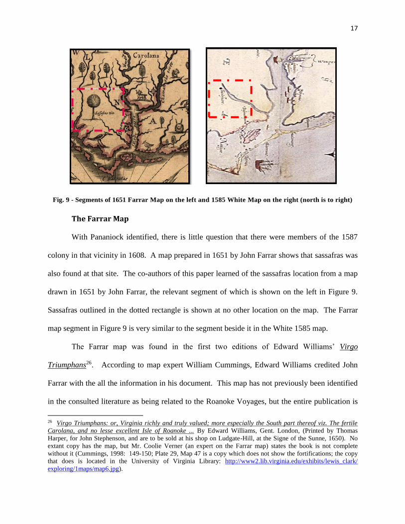
Fig. 9 - Segments of 1651 Farrar Map on the left and 1585 White Map on the right (north is to right)
The Farrar Map
With Pananiock identified, there is little question that there were members of the 1587
colony in that vicinity in 1608. A map prepared in 1651 by John Farrar shows that sassafras was
also found at that site. The co-authors of this paper learned of the sassafras location from a map
drawn in 1651 by John Farrar, the relevant segment of which is shown on the left in Figure 9.
Sassafras outlined in the dotted rectangle is shown at no other location on the map. The Farrar
map segment in Figure 9 is very similar to the segment beside it in the White 1585 map.
The Farrar map was found in the first two editions of Edward Williams’ Virgo
Triumphans26. 17According to map expert William Cummings, Edward Williams credited John
Farrar with the all the information in his document. This map has not previously been identified
in the consulted literature as being related to the Roanoke Voyages, but the entire publication is
26 Virgo Triumphans: or, Virginia richly and truly valued; more especially the South part thereof viz. The fertile
Carolana, and no lesse excellent Isle of Roanoke ... By Edward Williams, Gent. London, (Printed by Thomas
Harper, for John Stephenson, and are to be sold at his shop on Ludgate-Hill, at the Signe of the Sunne, 1650). No
extant copy has the map, but Mr. Coolie Verner (an expert on the Farrar map) states the book is not complete
without it (Cummings, 1998: 149-150; Plate 29, Map 47 is a copy which does not show the fortifications; the copy
that does is located in the University of Virginia Library: http://www2.lib.virginia.edu/exhibits/lewis_clark/
exploring/1maps/map6.jpg).
18
focused on the 1585 Roanoke expedition, and the map was specifically customized to fit with the
Virgo Triumphans publication. It is important to note that there are significant fort locations on
the Farrar map, one in the area of a location long-called “Fort Landing”, at the mouth of the
Alligator River, and a second fort depicted on the Chowan River, near the location of the
Chowanock Indian site on the White map. The forts and the sassafras tree strongly support the
contention that Farrar had Harriot’s Chronicle and materials related to the attempted settlement
of the 1585 voyage when he compiled Virgo Triumpans and drew the above map. No other
extant documents have been identified showing fortifications at these locations.
It is not until the Farrar Map, the White Map, and the DeBry Map (along with the Percy
and Zuniga maps), are all compared with each other that a true significance of the sassafras tree
on the Farrar map becomes evident. The location of the sassafras tree on the Farrar map is
correlated to Tramanskecooc on the White map because the two locations are identical, and the
Farrar map, although drawn 70 years after the White map, is most probably taken from the 1585
information supplied by Thomas Harriot himself, because the time spanning the two maps is
almost a completely dark period with no apparent re-colonization of the area in question. 18
The DeBry map is also relevant because of its timing with Thomas Harriot’s Brief &
True Report, which for the first time acknowledges that a secret commodity in a secret location
has been found, but they are not divulging what it is. The clue is shown in the Farrar map, with
only one tree labeled among the 30+ depicted: sassafras27. The 1590 White-DeBry map was one
27 Background research of why and how the Farrar map gains such a prominent role in deciphering the information
from this location can only be evaluated when the context of the book it was attached to, Virgo Triumphans, is
thoroughly studied (see Footnote 26). With close scrutiny, many other items in Virgo Triumphans are expanded
well beyond information that can be found in Brief & True Report or any other colonist writings. All of the above
gives a clear impression that John Farrar is writing about the 1585 colony from primary sources not available to
anyone else, making it evidently clear the 1587 colony was intending to procure the commodity of sassafras from
Beechland on the Alligator River.
19
of the centerpieces of Thomas Harriot’s Brief and True Report28.19 Harriot wrote that this report
would be followed by a fuller report: “I have ready in a discourse by itself in maner of a
Chronicle according to the course of times, and when time shall bee thought convenient shall
be also published29.”20 In the introduction to Harriot’s True Report, editor Paul Hulton stated:
“Of Harriot’s Chronicle, which we know he compiled during his time with the colony, nothing
remains but an abstract30.”21
However, others (including the co-authors of this paper) have concluded that Farrar must
have had access to the Chronicle31”; such access would likely explain why Virgo Triumphans
and Farrar’s map included more specific information about the region than was found in
Harriot’s Brief and True Report32. 22All of the principle people on the 1585 voyage are
mentioned repeatedly in Virgo Triumphans33.23
Thomas Harriot must have learned that there was sassafras at Tramanskecooc when he
spent 1585 and 1586 in Virginia with Ralph Lane. Sassafras almost certainly was one of the two
secret commodities referred to by Harriot in Brief and True Report34: 24
“Two more commodities of great value one of certaintie . . . there to be raised & in short
time to be provided and prepared, I might have specified. So likewise of those
commodities already set downe I might have said more; as of the particular places where
they are founde and best to be planted and prepared: . . . but because others then
welwillers might bee therewithall acquainted, not to the good of the action, I have
28 Thomas Harriot, A Briefe and True Report of the New Found Land of Virginia: The Complete 1590 Theodor de
Bry Edition, Paul Hulton, Ed., (New York: Dover), 1972: 42-3. Note: unlike the previously shown White map of
1585, Tramanskecooc is on the north side of the river (see Footnote 21). 29 Harriot/Hulton, 1972: 32-3; Quinn, The Roanoke Voyages, (1955): 387. 30 Harriot/Hulton, 1972: ix. At his death, Harriot had all his papers regarding the Roanoke Voyages burned (see
“Harriot/Percy Relationship” in Appendix). 31 Cummings, 1998: 149. 32 William Cummings first suggested this when he wrote: “Information on the map was apparently derived from
various sources available to John Farrer (Ferrar, Farrar), long an important officer in the Virginia Company;
many details show that he drew upon reports and first-hand information not found in the printed maps of the
period.” Cummings, 1998: 149. 33 Willard, “Spies and Lies”: 7. 34 Harriot/Hulton, Brief and True Report: 12.
20
wittingly omitted them: knowing that to those that are well disposed I have uttered,
according to my promise and purpose, for this part sufficient.”
There were huge profits being made on the sale of sassafras in England and Europe at the
time of the Roanoke voyages and the ten years afterward, and Raleigh profited from sassafras as
long as he held the charter to the New World (see “Consignment of Sassafras” and “Rariorum
plantorium listoria” in Appendix). The Virginia Company arrived in Jamestown with full
knowledge of the value of sassafras, because the president of the Jamestown council said in
1607: “Our easiest and richest commodity [is] sassafrass35.”25 According to Rariorum
plantorium listeria, a recently discovered translated Latin document, large amounts of sassafras
were being imported into England, and according to the document and its translation, the
sassafras was coming from Sir Walter Raleigh’s “Wingandecao” (sic.), which is the name first
presented on all the documents for the patents of Raleigh’s new lands in Virginia.
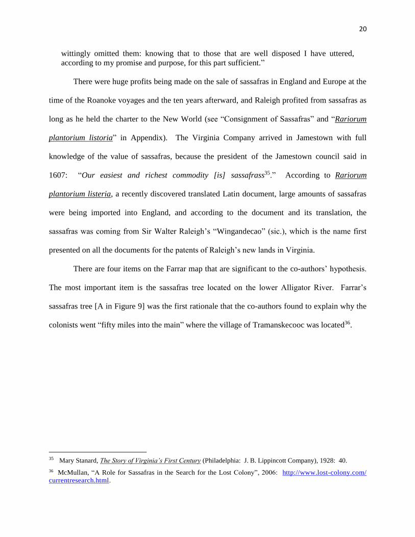
There are four items on the Farrar map that are significant to the co-authors’ hypothesis.
The most important item is the sassafras tree located on the lower Alligator River. Farrar’s
sassafras tree [A in Figure 9] was the first rationale that the co-authors found to explain why the
colonists went “fifty miles into the main” where the village of Tramanskecooc was located36.26
35 Mary Stanard, The Story of Virginia’s First Century (Philadelphia: J. B. Lippincott Company), 1928: 40.
36 McMullan, “A Role for Sassafras in the Search for the Lost Colony”, 2006: http://www.lost-colony.com/
currentresearch.html.
21
Fig. 9 - Farrar Map Segment37
The label ‘Dasamoncak’ at [B] is shown on the southern shore of the “Rolli Passa”
[“Raleigh Passage” or Albemarle Sound]. When the co-authors first began their research, they
were under the impression that Dasmonsquepuce was a Secotan village that is now Mann’s
Harbor. With the discovery of the Farrar map, which is believed to be related to the lost Thomas
Harriot Chronicles, it was indicated that the village had been moved inland, and also designated
with an English fortification near the Alligator River. Stephen Weeks, North Carolina’s first
professional historian, recognized this realignment more than 100 years ago. 27
Weeks wrote that Dasmonsquepuce was a peninsula named after a village at its center.
He said that the peninsula known to the explorers of 1585 as ‘Dasmonsquepuce’ is the same
general location as ‘Pananiock’ on the Zuniga map. He believed that the colonists were led into
37 John Farrar, “A mapp of Virginia discovered to ye Hills, and in it’s Latt: From 35. deg. & ½ neer Florida, to 41.
deg. bounds of New England” (Collegit: Domina Virginia Farrar. Sold by I. Stevenson at ye Sunne below
Ludgate), 1651: (University of Virginia Library) http://www2.lib.virginia.edu/ exhibits/lewis_clark/exploring/
1maps/map6.jpg
A
B
C
D
22
the Dasamonquepeuc interior by the Croatoan Indians after Governor John White had declared
Manteo ‘Lord of Dasamonquepeiuc and Roanoak’ for his faithful service38, and was a directive
of Sir Walter Raleigh himself, in all probability to protect the owners’ investments in sassafras39.
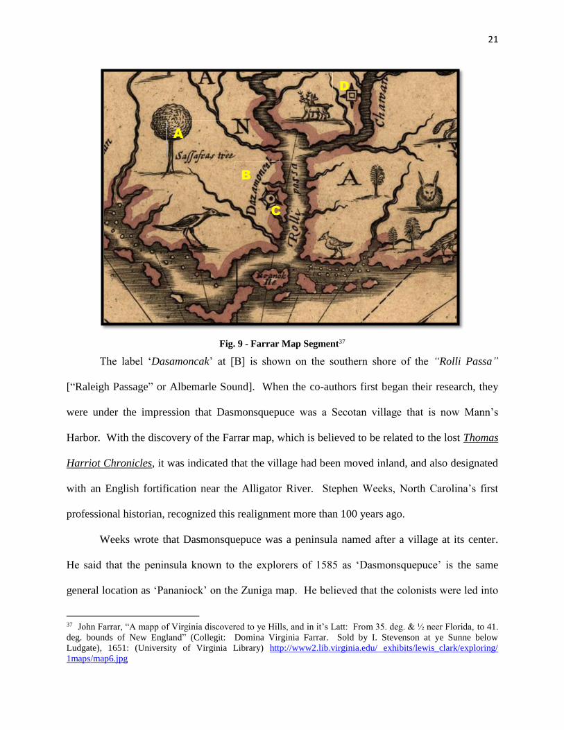
Fig. 10 - Dasamonquepeuc on White 1585 A, and Croatan on Speed 1676 (center) and Morden 1688 (right)40
Weeks presented a number of maps in which the entire peninsula was first labeled
Dasamonquepeiuc (as in the Farrar map) and then ‘Croatan’ in later historic maps41.28Figure 10
contains three of Weeks’ referenced maps. The co-authors agree with Weeks that this is
evidence that the Croatan and their English allies had become masters of a large area of land
around the Alligator River, after having totally supplanting the once-powerful Secotan
Confederation, which was never heard from again after Manteo became “Lord of
38 Stephen B. Weeks, The Lost Colony of Roanoke: It’s Fate And Survival (New York: The Knickerbocker Press),
1891: 24-5
39 Quinn, 1955: 531.
40 “White 1585 Manuscript Map A”, Cummings, 1998: Plate 11, Map 7; “Speed 1676 Map”, Cummings, 1998:
Map 77, Color Plate 4; “Morden 1688 Map”, www.cummingmapsociety.org/17thC_Maps.htm. 41 ‘Croatan’ is the name of the Indian people who befriended the English, and ‘Croatoan’ means ‘the land of the
Croatan people’. Weeks, 1891: 23-4. The co-authors of this paper concur with Weeks.
23
Dasamonquepeiuc and Roanoak”42, centered 50 miles inland “into the main” from the original
Roanoke settlement. 29
Two different symbols for fortification are on the Farrar map at [C] above ‘Dasamoncak’
and on the Chowan River at [D]. The fortifications are consistent with Ralph Lane’s practice of
building a protective enclosure wherever he would camp for any period of time43. The difference
between the square fortress symbol on the Chowan River and the circular fortress symbol on the
Albemarle Sound shore is not yet explained, but they must have had meaning to Farrar (see Fig.
10).
The co-authors suggest that the fort beside Dasamoncak may have been a signal fort, on
watch for Spanish ships entering the Albemarle Sound. Signal forts were often used as decoys to
protect and alert the main fort: while the signal fort is in easy view, the main fort is hidden
further back inland, and if any enemies attack, it will be the signal fort which is attacked first,
giving the main fort time to mount a defense and/or a counterattack. This is evidenced by Ralph
Lane building small fortifications at the point of Shallowbag Bay and the northern end of
Roanoke Island, and further documented in the instruction to Raleigh’s colony to always place a
second fort where retreat is possible44. 30
42 Weeks, 1891: 25. The area of control of the Croatan Indians supersedes the entire area of the Secotan
Confederation, which controlled this large peninsula at the Contact Period. This only could have transpired with a
partnership with the English colony, who had cannons, guns and superior military technology. This area
encompassed the region of the Roanoke River (Plymouth, NC today), all of the Pamlico River, Lake Mattamuskeet,
the Outer Banks, to Roanoke Island and the entire Albemarle Sound area (see Morden 1688 map above). The co-
authors of this paper were able to determine this by in-depth map research study, which all indicated that the
Croatans moved inland immediately after the ceremony with Manteo, “the 13th of August 1587, by the
commandment of Sir Walter Raleigh.” Quinn, 1955: 431.
43 There have been nine confirmed fortifications (so far) credited to Sir Ralph Lane. See “Ralph Lane
Fortifications” in Appendix for details on them.
44 Quinn, 1955: 134.
24
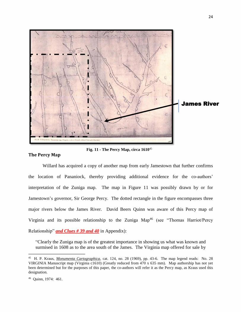
Fig. 11 - The Percy Map, circa 16104531
The Percy Map
Willard has acquired a copy of another map from early Jamestown that further confirms
the location of Pananiock, thereby providing additional evidence for the co-authors’
interpretation of the Zuniga map. The map in Figure 11 was possibly drawn by or for
Jamestown’s governor, Sir George Percy. The dotted rectangle in the figure encompasses three
major rivers below the James River. David Beers Quinn was aware of this Percy map of
Virginia and its possible relationship to the Zuniga Map46 (see “Thomas Harriot/Percy
Relationship” and Clues # 39 and 40 in Appendix):32
“Clearly the Zuniga map is of the greatest importance in showing us what was known and
surmised in 1608 as to the area south of the James. The Virginia map offered for sale by
45 H. P. Kraus, Monumenta Cartographica, cat. 124, no. 28 (1969), pp. 43-6. The map legend reads: No. 28
VIRGINIA Manuscript map (Virginia c1610) (Greatly reduced from 470 x 635 mm). Map authorship has not yet
been determined but for the purposes of this paper, the co-authors will refer it as the Percy map, as Kraus used this
designation.
46 Quinn, 1974: 461.
James River
25
Mr. H. P. Kraus of New York in 1969 has perhaps some relationship to the Zuniga map.
If so, it is more likely to belong to late 1608 or early 1609 than the 1610 date tentatively
assigned to it. This map has four rivers entering the sea from the west to the south of the
James, but they are not sharply differentiated and contain no named locations, though a
total of fifteen half-circles, apparently indicating Indian village sites on them, are shown.
It might be suggested that this part of the map does reflect, though very faintly, the first
1608 expedition to the south, but there is nothing of evidential value in it for that area”47. 33
The co-authors do not agree with Quinn’s conclusion that “there is nothing of evidential
value in it” (due to the fact they have far more technologies, documentations, correctly correlated
maps, and related knowledge than Quinn did), but they do agree that “this part of the map does
reflect the first 1608 expedition to the south.” The half-moon shapes are representative of Indian
villages, as Quinn suggests, and their locations suggest knowledge of the John White maps of the
Albemarle Sound/Roanoke River, Pamlico Sound/Pamlico River, and the Neuse River (see
Appendix for “Percy Map with Villages Named”).
Willard has prepared a transparency of the dotted portion of the Percy Map in Figure 11.
He has reoriented the transparency 30 degrees to the left, changed the scale to match, and placed
it over a modern North Carolina map in Figure 12. Thus oriented, the upper two water bodies in
the Percy map are notably representative of the Pamlico and the Albemarle Sounds, which is the
main focus of the map. The precise alignment of the river orientation strongly indicates that
whoever drew this map must have actually visited the site in 1608, because such accuracy can
only come from first-hand knowledge of the area. All known maps prior to the Percy map have
total misalignment of the two bodies of water. Every circle on the Percy map is identifiable with
a known Indian village, derived from other maps, and is in the same approximate
Pamlico/Albemarle/Neuse River area. The more interesting addition to the map in Figure 12 is
two black dots (accented in red) and a line pointed to by two arrows by the co-authors. That
47 Quinn, 1974: 460-462.
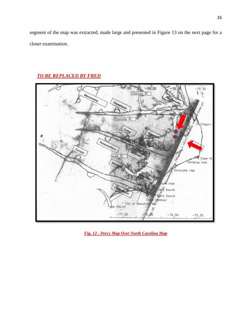
26
segment of the map was extracted, made large and presented in Figure 13 on the next page for a
closer examination.
TO BE REPLACED BY FRED
Fig. 12 - Percy Map Over North Carolina Map
27
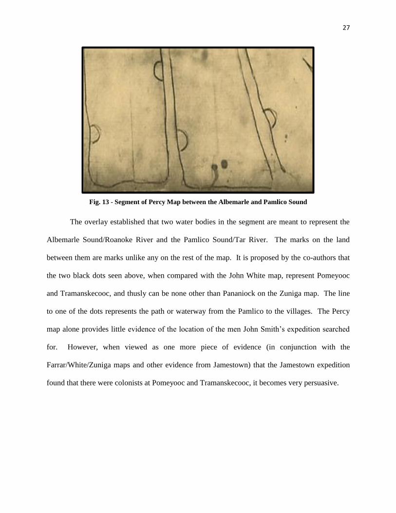
Fig. 13 - Segment of Percy Map between the Albemarle and Pamlico Sound
The overlay established that two water bodies in the segment are meant to represent the
Albemarle Sound/Roanoke River and the Pamlico Sound/Tar River. The marks on the land
between them are marks unlike any on the rest of the map. It is proposed by the co-authors that
the two black dots seen above, when compared with the John White map, represent Pomeyooc
and Tramanskecooc, and thusly can be none other than Pananiock on the Zuniga map. The line
to one of the dots represents the path or waterway from the Pamlico to the villages. The Percy
map alone provides little evidence of the location of the men John Smith’s expedition searched
for. However, when viewed as one more piece of evidence (in conjunction with the
Farrar/White/Zuniga maps and other evidence from Jamestown) that the Jamestown expedition
found that there were colonists at Pomeyooc and Tramanskecooc, it becomes very persuasive.
28
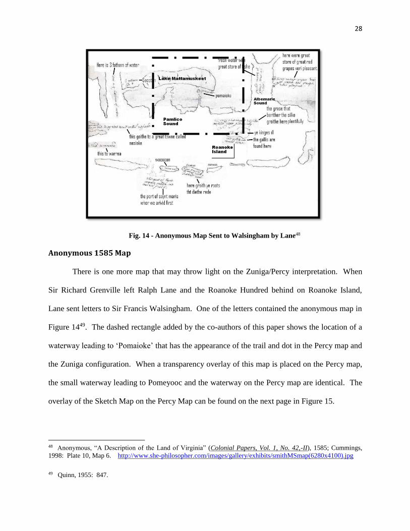
Fig. 14 - Anonymous Map Sent to Walsingham by Lane4834
Anonymous 1585 Map
There is one more map that may throw light on the Zuniga/Percy interpretation. When
Sir Richard Grenville left Ralph Lane and the Roanoke Hundred behind on Roanoke Island,
Lane sent letters to Sir Francis Walsingham. One of the letters contained the anonymous map in
Figure 1449. The dashed rectangle added by the co-authors of this paper shows the location of a
waterway leading to ‘Pomaioke’ that has the appearance of the trail and dot in the Percy map and
the Zuniga configuration. When a transparency overlay of this map is placed on the Percy map,
the small waterway leading to Pomeyooc and the waterway on the Percy map are identical. The
overlay of the Sketch Map on the Percy Map can be found on the next page in Figure 15.
48 Anonymous, “A Description of the Land of Virginia” (Colonial Papers, Vol. 1, No. 42,-II), 1585; Cummings,
1998: Plate 10, Map 6. http://www.she-philosopher.com/images/gallery/exhibits/smithMSmap(6280x4100).jpg
49 Quinn, 1955: 847.
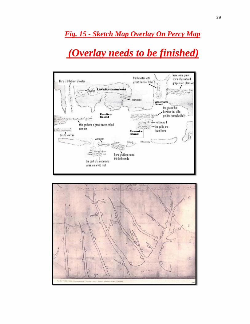
29
Fig. 15 - Sketch Map Overlay On Percy Map
(Overlay needs to be finished)
30
Conclusions
The mystery of the Lost Colony is tantalizing, romantic, and one riddled with controversy
and problems. Many academic factions have been arguing about their ultimate fate, and their
disagreements and altercations have not been resolved by any concise agreement. Although all
of the scholars presented noteworthy facts to support their individual conclusions, to-date, no
two are in complete concurrence.
This research paper’s main thrust in helping to clarify a very confusing puzzle is relying
on the number of clues that point to the colony going native with the Croatan Indians, and the
overwhelming number of incidents that have been reported, that have centered near the coastal
settlement called the Beechland area. There are several instances that have documented that
splintered groups of the colony did in fact end up in several other locations. The main evidence,
indicating an Indian weroance named Eyanoco was involved with the colonists, was documented
from Jamestown (see “Chief Eyanoco” in Appendix).
In addition, several colonists were mentioned as being on the Chowanoc River near
Salmon Creek. A third location, called “Pakrawick”, is also well-documented from Jamestown
sources. The strongest evidence of the ultimate fate of the colonists rested on the John White
narratives, where he said they intended to go to Chesapeake Bay. All of the above scenarios are
bits of information with no supporting evidence ever found in the way of artifacts, documents,
skeletons, or genealogy that would support the surnames surviving.
Since 1982 the co-authors of this paper have also attempted to determine the fate of the
1587 colony, popularly known as the “Lost Colony.” McMullan began his research when he
uncovered the legend of Beechland, a community of indeterminate age in the heart of the Dare
County mainland, whose descendants have always claimed that their ancestors were a mixture of
31
Indians and Raleigh’s Colonists. A few years later, Willard became obsessed with the fate of the
colonists when he and Barbara Midgette became responsible for uncovering European artifacts in
the Croatan Indian village in Buxton on Hatteras Island50 in 1993, discovering the location of the
relict inlet of Port Ferdinando51 and most importantly, discovering thousands of living
descendants of the Croatan/Hatteras/Mattamuskeet Indians who all came from the Beechland
area52. After independently coming to the same conclusion about the fate of the colonists at
Beechland, the co-authors began to share their related discoveries and present their results at
www.lost-colony.com, the website of the Lost Colony Center for Science & Research, Inc. 35
Thirty years of combined studies, using multidiscipline research in eight sciences
(archaeology, biology, geography/map studies, computer science/satellite-imaging, geology,
history, genealogy, and DNA studies), have given these co-authors a strong research basis in
realizing that hundreds of clues related to the Lost Colony are all emanating out of one location:
Beechland, located on the coastal plain of North Carolina. The most popular paradigm related to
the Lost Colony for the last 100 years has been that they migrated to Chesapeake Bay and were
murdered by the great Chief Powhatan, proffered by David Beers Quinn, David Stick, and David
Phelps. A new wave of research first led by Thomas Parramore, Lee Miller, and the Lost Colony
Center for Science & Research, Inc. centered on a coastal North Carolina disposition, and an
absorption by the local Indians.
This new theme has gained so much success that in late 2011, Wikipedia acknowledged
the realignment of this paradigm. Lee Miller and the Lost Colony Center for Science &
50 Mary Helen Goodlow, “Trash Will Tell Very Tall Tale”, The Coastland Times (Manteo, NC: July 31, 1994):
www.lost-colony.com/Buxtonfind.html. 51 Fred L. Willard, Barbra Midgette, E. Thomson Shields (Edited by Charles Ewen), “The Roanoke Sagas:
Searching for the Roanoke Colonies” (North Carolina Department of Cultural Resources: Office of Archives and
History), 2003, http://www.lost-colony.com/sagas.html. 52 Willard, “Disappearing Indians”, 2000; McMullan, “A Search For The Lost Colony In Beechland”, 2002;
Willard, “Migration Patterns of Coastal N.C. Indians”, 1998.
32
Research, Inc. were given most of the credit for this paradigm shift. However, the leading
proponent and strongest advocate was and is Thomas Parramore, history professor of Meredith
College, who unfortunately died before this paradigm shift took place. 36
The above research has culminated into 23 highly-regarded research papers, three
academic research awards, two hundred lectures, eighty-nine television shows, and on July 14,
2007, with the announcement of the DNA Symposium, 234 thousand newspapers, bloggers and
media picking up the story of the DNA study and the Lost Colony being elevated to the most
important and exciting unsolved mystery in North America53. The Research Center received 15
thousand emails within the next few weeks after the story appeared in every major newspaper in
Europe and North America54.
There are still many proffered locations of which Indians the 1587 Colony settled with.
At this time, the overwhelming amount of evidence suggests that the location of the new
settlement was in fact Beechland (also known as “Wocondaland”, Tramansquecooc,
Dasmansquepuce and on all of the Raleigh patents as “Assomacomuck”, which all fall within 50
miles of Roanoke Island, as indicated by the governor of the Colony, John White himself, on
more than one occasion).
Until the ultimate indisputable evidence is found, the area of research should focus on the
totality of the clues, and what story or fate can be derived from the preponderance of the
evidence available at the time (please refer to the 41 important clues in the Appendix).
53 see www.lost-colony.com, “Overwhelming Response To DNA Project Symposium”
54 see www.lost-colony.com, “DNA Project, Croatan Indians, Sir Walter Raleigh”
33
APPENDIX
I. Most Important Breadcrumb Clues On This Trail
The research presented in this paper is the first attempt to categorize, dissect, and
assimilate all the bits of information about the Lost Colony---scattered like breadcrumbs---into a
format that locates their final destination, after they had removed themselves from Roanoke
Island (possibly 1588) to the mainland, never to be seen again. Of the many theories developed
as to what happened to them, only four or five are now considered valid. The evidence listed
below, compiled by the co-authors of this paper, strongly suggests all remaining evidence points
to one location: Beechland (Hyde, Tyrell, & Dare Co. and the Pungo/Alligator River area),
which from 400 years ago to today can only be accessed by small watercraft.
1---James Sprunt recorded Coree Indians informed the Barbados colony at Cape Fear, in
1654, that the Lost Colony had survived and were living with Yeopim and Hatteras Indians at
Croatan. After Cape Fear foundered, they re-established the Barbados colony on the north shore
of the Albemarle River and intermarried with the Hatteras Indians (see Fred L. Willard, “The
Machapungo Indians and the Barbados Connection 1663 to 1840”, East Carolina University:
Directed Studies in History for Dr. Angela Thompson, http://www.lost-colony.com/
currentresearch.html, Lost Colony Center for Science & Research, Inc., 2008). Also note
John Lawson reported that these Indians dressed as English, and in the margin of his report wrote
“Hatteras Indians” (John D. Lawson, A New Voyage to Carolina, Edited with an Introduction
and Notes by Hugh Talmage Lefler (Chapel Hill: University of North Carolina Press), 1967:
200-20).
34
Quoting Sprunt: “The Hatteras tribe numbered about 3,000 warriors when Raleigh’s
expedition landed on Roanoke Island in 1584, and when the English made permanent settlements
in that vicinity, 80 years later, they were reduced to about 15 bowmen. The Cape Fear Coree
Indians told the English settlers of the Yeamans colony in 1669 that their lost kindred of the
Roanoke colony, including Virginia Dare, the first white child born in America, had been
adopted by the once-powerful Hatteras tribe and had become amalgamated with the children of
the wilderness. It is believed that the Croatans of the vicinity are descendants of that race”
(James Sprunt, Tales and Traditions of the Lower Cape Fear: 1661-1896, Wilmington:
Carolina Insurance Co., 1896, Printed by Acquintin Bros., P. 54-55).
2---In the Beechland chapter of his 1966 book, “Legends of the Outer Banks and Tarheel
Tidewater”, Judge Charles Whedbee wrote: “Within the memory of men still living, there was at
Beechlands [sic] a tribe of fair-skinned, blue-eyed Indians”. Was it just coincidence, he asked,
that some bore the names of colonists on Governor White’s rolls; names such as John White,
Culbert White, Thomas Coleman, Richard Taverner, John Gibbs, James Hynde, Michael Bishop,
Thomas Phevens, and Henry Paine? (Lawson, A New Voyage to Carolina, 1967: 200-20
(primary source); Charles Whedbee, Legends of the Outer Banks and Tar Heel Tidewater,
“Beechland” (Winston-Salem: John F. Blair, Publisher), 1966: 31).
3---Lawson’s accounts of the native populations are more detailed and are the best early
records yet found to-date. New-found evidence has been discovered that the
Pasquotank or Yeopim Indians make up a very large percentage of the Hatteras/Croatan Indians
when they resided in the Beechland area some 60 to 100 years after the settlement was left on
Roanoke Island in 1587. For a more in-depth reading of how these Pasquotank Indians ev9lved
as English, please refer to Clue #42 and the research paper “The Machapungo Indians and the
35
Barbados Connection 1663 to 1840”. Lawson reports that the Pasquotank/Paspitank (sic)
Indians did formally keep cattle and make butter. He also made a profound statement relating
specifically to the culture, manners and dress of these Indians, and furthermore, that they are
different from all other natives he has encountered: “The dresses of these people are so different,
according to the Nation that they belong to. . .” “. . .which wear Hats, Shooes, Stockings, and
Breeches, with very tolerable Linnen Shirts, which is not common amongst these. . .” Native
Americans (Willard, “The Machapungo Indians and the Barbados Connection 1663 to 1840”,
citing Lawson, 1967: 200-1).
4---Appleton magazine article on P. 24 about a priest in 1660 preaching to white Indians
on the Pantego River that could speak English: “In 1660 the Rev. Morgan Jones, of Virginia,
was captured by the Tuscarora Indians living in North Carolina along the Neuse River. After
some time in captivity he returned civilization to make the solemn statement that he had found a
tribe settled on the Pantego River, near Cape Atros (Hatteras), known to their neighbors as the
white Indians on account of their light color; he tells that they spoke British, in which language
he preached to them three times a week.” (Alexander Hume Ford, “The Finding of Raleigh’s
Lost Colony”, Appleton’s Magaine (Location: The Library of the University of North Carolina
at Chapel Hill, Department: The Collection of North Carolina, Registration #: Cp970.03,F69f,
ID #: 00032198381), July 1907: 22-32, http://archive.org/stream/findingofraleigh00ford#page/
30/mode/2up).
5---John White, the governor of the 1587 colony, twice states that they intended to move
to Chesapeake Bay but changed their minds and intended to place their new city and fortification
fifty miles into the main from “Roanone” (Quinn, 1955: 1001): 1587: “Also he (John White)
alleaged, that seing they intended to remoue 50. miles further vp into the maine presently, he

36
(John White) being then absent, his stuff and goods, might be both spoiled, and most of it
pilfered away…” (Quinn, 1955: 533-534) and 1590: “…for at my coming away they were
prepared to remoue from Roanoke 50 miles into the maine” (Quinn, 1955: 613). According to
calculations and studies of modern maps, the proffered location is cited on the Alligator River,
and this correlates with incidents occurring along its banks.
6---Publication of A Brief and True Report by Thomas Harriot mentions secret
commodities, but will not divulge their location: “Two more commodities of great value one of
certaintie, and the other in hope, not to be planted, but there to be raised & in a short time to be
provided and prepared, I might have specified. So like wise of those commodities already set
downe I might have said more; as of the particular places where they are founde ----; But
because others then welwillers might bee therewithall acquainted, not to the good of the action, I
haue wittingly ommited them: knowing that to those that are well dsposed I have uttered,
according to my promise and purpose, for this part sufficient” (Harriot/Hulton, Brief and True
Report: 12; Quinn, 1955: 314).
7---“Mysteriously” Tramanskecooc village was removed almost immediately from the
map after the publication of Thomas Harriot’s Brief and True Report (see Quinn: White 1585
Manuscript B vis a vi White-DeBry 1590).
8---At Sir Walter Raleigh’s request a ceremony took place, proclaiming Manteo “Great
Lord and Chief of Dasemunkepeuc (many variant spellings)”, enabling Manteo to have supreme
authority of all the Indians in the area, under Raleigh and his representatives’ command, on the
31st of August 1587 (which was just five days before Virginia Dare was born). This gave
Raleigh control of over 4 million acres of land, and protected the location of his transplanted
37
village and secret commodities (see Farrar map, indicating sassafras & English forts, and the
movement of Dasmansquepuce) (Quinn, 1955: 504-5, 531).
9---Although it has now become evident, scholars have totally missed that the once-
powerful Secotan Confederacy was completely supplanted by the small Croatan Indian tribe. It
is very doubtful that the Croatans could have achieved this feat without a partnership with the
English, as outlined in Clue #8 (see above). The documentation that this in fact did occur can be
found on the maps on Pages 10, 11, and 27-9 of “Spies & Lies”).
10---The notations found on the Zuniga map---from the Jamestown sources, only 30
years after the colony is lost---are the most important clues concerning the Lost Colony of 1587.
Although the notations are the most important evidence to-date supporting the co-authors’
hypothesis (supported by renown historian David Beers Quinn), the rough-drawn sketch map
lacks definitive locations of the Indian villages because the map is not drawn to scale. This
problem is in all probability resolved with the discoveries of the Farrar and Percy maps, as they
more accurately determine the location of the Pomeyooc village (a.k.a. “Pananiock” or
“Panawiki”).
11---William Cummings reports that John Farrar, mapmaker, had access to papers,
reports, and information that were not available to others, and also that Farrar commissioned
Williams to write Virgo Triumphans, and all the information about the 1585 Roanoke voyage
was obtained from him (Cummings, 1998: 148). On his map in Virgo Triumpans (not in any
extant copy today) is a sassafras tree (at the location of the Tramanskecooc Indian village on the
White 1585 map) and two English fortifications located at Fort Landing and near the Chowanoc
Indian village (this information in all probability could only have come from Thomas Harriot’s
lost-lost Chronicles).
38
12---Discovery of the Percy map, and comparing it with the Zuniga, White and Farrar
maps shows that the possible location of Pomeyooc and Tramanskecooc is forthcoming. How
every Indian village in North Carolina is named helps to identify locations on the map.
13---Many accounts from the body of literature from Jamestown place survivors of the
Lost Colony in the area or near the territory of the expanded Croatan Empire. The most
important citation relating to survivors in the Croatan dominion is the village of Pomeyooc (sic),
which is near Engelhard, North Carolina today (see Pages 30-34 of “Spies & Lies” for Zuniga
map and Percy Map and correlating citations relating to survivors of the Lost Colony, from
Jamestown). The location of Pomeyooc (a.k.a. Pananiock) is easily referenced by White’s 1585
Manuscript Map B and the Farrar map.
14---Richard Hakluyt to Sir Walter Raleigh letter in 1587: “One of your followers knows
about the ‘certain secret commodities’ already discovered by your servants” (Quinn, 1955: 545,
548-9).
15---Letter of Ralph Lane to Richard Hakluyt, 1585: “And we have found rich
commodities and apothecaries and drugs” (Quinn, 1955: 207-9, 336-7).
16---The ship’s log of the Primrose, one of Drake’s ships that relieved the 1585 colony,
has notations that there are large amounts of sassafras stored in the hold to take back to England,
and that sassafras was the most valuable commodity in all of North America (Quinn, 1955: 35,
303-8).
17---From 1588 to 1605 at least 60 ships were sent out under Raleigh’s command or by
investors in the Roanoke Colony. This hard, indisputable clue has been documented with words,
papers and articles written by many scholars over centuries of research---and has also not been
39
detailed before now (see “Voyages” in Appendix). These voyages are all important to determine
the possible location of where the Lost Colony went.
18---From 1600 to 1605 Samuel Mace is documented on five voyages to find the Lost
Colony, and to trade copper for sassafras, but he said he landed south of Roanoke and had to turn
back every time because of “foul weather” (see “Voyages” in Appendix).
19---Captain Martin Pring is sent in ships to find sassafras in 1603 (Miller: 207-8: “On
April 10, 1603, a Captain Martin Pring, in command of the Speedwell and Discoverer, sailed to
North America and returned with their holds full of sassafras. Interestingly, they were reported
to have landed far north of Roanoke Island, but at the same time, many accounts that Sir Walter
Raleigh’s colony had again been contacted were reported from several sources”).
20---David Glavin in a deposition after being captured by the Spanish reports that
Richard Hawkins, when captured, was attempting to obtain sassafras in 1595-6 (Miller: 207-8;
and also Quinn, 1955: 834. While in the hands of the Spanish at St. Augustine, Glavin claims
two additional ships were provisioned to go to Jacan (Roanoke Island) in 1599, carrying supplies
of people, ammunition, clothes, implements, axes and spades for the settlers there).
21---John Brereton in a paper to Sir Walter Raleigh, 1594: “A company of men manned a
new ship and were paid weekly wages to ensure they would not go after ships for plunder, and
they are to secure sassafras and instructed to seek out the 1587 colony” (Miller, 2000: 207-8).
22--- In 1605 two ships again are sent to Croatan and instructed to get sassafras, the
Castor and the Pollux. But the Castor and Pollux were captured by the Spanish (Phil Jones,
Raleigh’s Pirate Colony in America: The Lost Settlement of Roanoke 1594-90 (Charleston, SC:
Tempus Publishing Co.), 2001: 101-2).
40
23---The “smoking gun” clues, why the Lost Colony was lost: “Raorium” &
“Consignment of Sassafras” (see further below in Appendix). These two documents are the
most important confirmation that Sir Walter Raleigh and his investors were aggressively
importing sassafras into England, and that the location of the sassafras was Raleigh’s “lost” city
and from other sources (Farrar map and White’s “inexplicable” sounding of Chicandapiko (sic)
Inlet in 1590 (see Clue #29 below)). In addition, the considerable but not-yet-confirmed
evidence that there are at least 60 voyages by Raleigh and his investors, that place them close to
Pomeyooc, cannot be ignored (see Clue #17 above and “Voyages” below).
24---1958: Several hand-hewn (riven) coffins were discovered just a few miles from the
location of the sassafras tree on the John Farrar map (see p. 26 in “Spies & Lies”), and these
coffins had Moline crosses carved on them, which were only used during Queen Elizabeth’s
reign (McMullan, “A Search for the Lost Colony in Beechland”: http://www.lost-
colony.com/currentresearch.html).
25---It has been reported by the locals and documented by many sources that a Mr.
Mason, while logging in the area, stumbled upon a large pile of stones. There are no natural
stones in the coastal area, and the location is inaccessible by land, and could have only been
procured in this location from ballast stones (something all colonial ships would have had). As
in the instance outlined above, the location is within a few miles of the depicted John Farrar
sassafras tree (see p. 26 in “Spies & Lies” paper) (Personal communication with Marco Gibbs
(2002-2012) and Mr. Mason’s brother (1998) by the author Fred Willard. This stone pile has had
two failed expeditions attempting to relocate it).
26---Some very interesting findings have been located in the wilderness area triad of
Dare, Hyde, and Tyrell Counties. These discoveries are all within a few miles of the
41
Tramaskecooc Indian village on the White 1585 Map, and also correlate exactly with John
White’s statement for the new location of the colony fifty miles into the mainland. A very large
stand of English walnut trees was purported to have been found and harvested in the area around
sixty years ago, reported by the men who harvested the stand that it was half a mile long, and all
the trees were planted in a straight line. Although English walnut was common to the area, no
large tracts like this one have ever been found, indicating human intervention for intended
harvesting. No known community in recorded history has lived in this area (Morgan H. Harris,
Hyde Yesterdays: A History of Hyde County (Wilmington: New Hanover Printing & Publishing,
Inc.), 1995: 18. The co-author Fred Willard has received personal communication from many
residents of Hyde County who have relayed the same information, and every account verifies
that this location has never supported a known community in historic times).
27---In the heart of the Beechland area, which is a complete wilderness area now,
numerous pieces of evidence (which are all proof of cultural features) have been found. A stand
of full-cup oak trees (about 20), were found planted in a straight line between 2005 and 2009 by
the co-authors of this paper (CITATION!!!). In addition, a hand-dug well, grave-markers, riven
coffins with Elizabethan crosses, a pile of ballast stones, a hand-dug ditch, and a stand of English
walnut and chestnut trees have all been found in the same general area. All of these cultural
features have been documented from multiple sources by the co-authors of this paper (see
Willard, “Conspiracy, Spies, Secrets & Lies” and McMullan, “Beechland & The Lost Colony”).
28---The Croatan site has produced thirty to forty thousand artifacts, of which some of
the most significant English artifacts have been dated to the time of the Roanoke Voyages. It
should be noted that the inlet at Croatan is due east of Pomeyooc, which would be the natural
route for exportation of any commodities, and because of White’s sounding (see Clue #29), the
42
co-authors believe it was sassafras being shipped to England (see Goodlow, “Trash Will Tell Very
Tall Tale” and Jim Morrison, “In Search of the Lost Colony”, American Archaeology, Vol. 10,
No. 4 (Maryland: Archaeological Conservancy Quarterly Publication (Eastern Region)), Winter
2006-2007: 38-44, http://lost-colony.com/magazineAA.html).
29---One of the most important events that has been previously overlooked is that the
John White Voyage ships land at Croatan on August 12, 1590. The next day, the boats sounded
the inlet (for what purpose?) (Quinn, The First Colonists (Raleigh, NC: Department of Cultural
Resources, Division of Archives & History), 1982: 123). It is proffered by the co-authors of this
paper that White’s interest in this inlet is for the exportation of commodities from Pomeyooc,
and related to sassafras being found in the area, and confirmed by the Farrar map. Farrar clearly
depicts a sassafras tree (note it is the ONLY one labeled on the entire map; why, do you
suppose?), and the co-authors believe that Farrar had access to documents from Thomas Harriot
pertaining to the area in question.
30---Four to seven hundred Hatteras/Mattamuskeet Indians were found to be living in
Beechland in 1700 (about eight miles from the location of the Farrar sassafras tree, see map on p.
26 in Willard, “Spies & Lies”). Research, deeds, oral history, and related Indian literature have
identified 100 surnames that migrated out of this area after an endemic plague struck in 1840
(black-tongue plague). An interesting phenomenon has occurred in that 49 of these same
surnames are on the roster of the 1587 John White Colony (see “Spies & Lies” p. 12 for Elks
Deed and 22-3 for other deeds) (see Catherine Kozak, “New Hints to Lost Colonists
Found”(Hampton Roads, VA: The Virginian-Pilot), March 31, 2001: www.lost-colony.com/
newspaper.html; and also Mary Wood Long, The Five Lost Colonies (Elizabeth City: Family
Research Center), 2000; Ralph Pool, “‘Lost Colony Wasn’t’ Old Tradition Says” (Hampton
43
Roads, VA: The Virginian-Pilot), July 3, 1960; and McMullen, “A Search For The Lost Colony
In Beechland”).
31---Anthropology report of 1916 discovering remnants of Matchapungo/Croatan
Indians, Pugh being the most important surname (Frank G. Speck, “Remnants of the
Machapunga Indians of North Carolina”, American Anthropologist Vol. 18, No. #2, (Arlington,
VA: American Anthropological Association), April-June 1916: 271-276).
32---Possibly one of the most important clues recently found, although not supported by
any history books prior 2001, is the survival of a huge Croatan/Hatteras/Mattamuskeet Indian
community that all have English, Irish and Scottish names. Of all these surnames, 49 have been
found on the roster of the 1587 Colony (see Clue #30). These surnames were all obtained by
court documents of deeds, wills, birth and death certificates, and narration of early North
Carolinian records. The only challenge that can possibly be made is that these documents were
inaccurately recorded.
33---One of the earliest and important documents is of the connection between the Lost
Colony and the Lumbee Indians. For over a hundred years, scholars have documented their
findings, and the co-authors of this paper support all this research (McMullan, “Beechland & The
Lost Colony”), with one caveat: the timing of the migration westward to Lumberton did not
happen in 1587, but it was a reaction resulting from the English intrusion (and the ensuing
kidnapping of their children for the English slave trade) starting in 1650 and resulting in the
Tuscarora War in 1711 (Fred Willard, The Machapungo Indians and the Barbados Connection
1663 to 1840 (East Carolina University: Directed Studies in History for Dr. Angela Thompson),
Lost Colony Center for Science & Research, Inc., 2008: http://www.lost-
colony.com/currentresearch.html). In addition, it is strongly believed that another Indian
44
migration took place from coastal North Carolina when a devastating outbreak of “black-tongue
plague” (possibly anthrax) occurred in 1840 (see McMullan, “Beechland & The Lost Colony”
and Willard, “Conspiracy, Spies Secrets & Lies”).
34---One of the more important actions of John White, after he left the colony in 1587,
was that he immediately reorganized and negotiated with Raleigh a new group of investors,
offering them large parcels of land in the newly-settled Dasmansquepuce area, designated by the
ceremony with Manteo. The patents that were granted are all listed as being in “Wocondaland”,
also known as “Dasmansquepuce”, and on all the new patents in 1588 are listed as
“Assomacomuc” (which means the name of the territory of North Carolina). These are all
located within the designated parameters of John White’s comment: “We are going to relocate
50 miles into the main” (Quinn, 1955: 117, 508, 570, 572-3, 575, 854: “This name
(Assomacomuc) emerges in 1587 and 1589, instead of “Wingandacoia” as the presumed
Carolina Algonquian territory for the mainland. Variant spellings are: Ossomocomuck,
Assamacomock, Asamacomock, Assamacomocke. Transliteration of this word by Professor
Gary: the land “opposite” or “facing””).
This can be construed as the land facing Roanoke Island and Dasmansquepuce, which
would indicate the land to the west, facing the land to the west, coinciding with the co-authors’
placement of all the clues referred to above. These in all probability, because of their timing
after the colony is settled, are the most important documents related to where the colony moved
(see Quinn, 1955: 506, Doc. 74: Jan. 7, 1587: “Grant of arms for the city of Raleigh in
Virginia, and for its governor and assistants”). These patents for land were issued before John
White sailed in 1587. It is noteworthy because the patents are in the country previously
discovered, called or now-termed Assomacomuc alias Wingandacoia alias Virginia, even though
45
that totally contradicts the later-written material of John White’s narratives of Chesapeake Bay
being where they intended to go.
Quinn, 1955: 569, Doc. 87: March 7, 1589: “Agreement between Sir Walter Raleigh,
Thomas Smythe, etc., and John White, etc. for the continuance of the city of Raleigh venture”.
This is the last patent granted for the new city of Raleigh two years after the colony disappeared,
and it is important to note that this is for Assomacomuc alias Wingandacoia alias Virginia, not
Roanoke. There is a whole new listed of colonists, based on the current research now being
performed, which most likely ended up in the new city of Raleigh.
35---One of the more significant recent discoveries relating to this research is an Indian
village depicted on the Alligator River on early maps. IKONOS imaging has located three sites
as possible locations for the colonists to have settled with the Croatan, and all three have been
identified and confirmed as Indian village sites (and located on many of the 16th- and 17th-
century maps along the Alligator). The IKONOS image resolution is so powerful and acute, it
can define a human standing from 420 miles in space. A 16-foot well and a foot-path trail can be
seen from this altitude (see Buck Ridge IKONOS image on next page) (Fred Willard, “The Lost
Chronicles of Thomas Harriot” (East Carolina University: Directed Studies in History for Dr.
Kenneth Wilburn), Lost Colony Center for Science & Research, Inc., 2007).
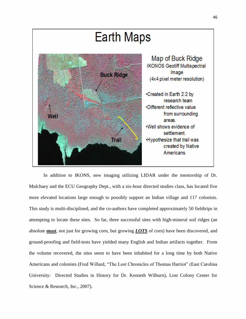
46
In addition to IKONS, new imaging utilizing LIDAR under the mentorship of Dr.
Mulchaey and the ECU Geography Dept., with a six-hour directed studies class, has located five
more elevated locations large enough to possibly support an Indian village and 117 colonists.
This study is multi-disciplined, and the co-authors have completed approximately 50 fieldtrips in
attempting to locate these sites. So far, three successful sites with high-mineral soil ridges (an
absolute must, not just for growing corn, but growing LOTS of corn) have been discovered, and
ground-proofing and field-tests have yielded many English and Indian artifacts together. From
the volume recovered, the sites seem to have been inhabited for a long time by both Native
Americans and colonists (Fred Willard, “The Lost Chronicles of Thomas Harriot” (East Carolina
University: Directed Studies in History for Dr. Kenneth Wilburn), Lost Colony Center for
Science & Research, Inc., 2007).
47
36----Wowinchopunk, the Paspahegh king gives a relation that the Lost Colonists are
well known at an Indian village called Panawicke (possibly on the upper Tar River near
Engelhard, North Carolina (the same village as Pomeyooc or Pananiock on the Zuniga map),
beyond Roanoke many clothed men who are appareled can be found. Wowinchopunk agrees “to
conduct two of our men to a place called Panawicki” (Miller, 2000: 214, citing Smith, True
Relation CR4).
37---Strachey reports about the 1587 Colony: “The Powhatton of Roanocke slaughtered
the colony (Miller, 2000: 250, 255, 258) at Ritino. The king Eyanoco (possibly a Siouan
Indian), where all but seven were killed. Four men two boys and a young maid who were sent to
the Chowan to beat the said King’s copper”. Strachey thought this meant Pocahontas’s father.
Powhatan can be translated as priest. This possibly should be reconsidered as saying: “The
priest of Roanoke -----”, placing the attack in or near the settlement of Roanoke Island or River.
38--- Stephen B. Weeks, on P. 17 in his book The Lost Colony of Roanoke: It’s Fate And
Survival, makes a very interesting observation about the goings on between White, Lane,
Walsingham, and Raleigh: “Raleigh had learned from the experience of former fleets that the
harbor of Roanoke was, as Lane had said, “very naught.” He instructed them therefore to
abandon the settlement on Roanoke, and to coast northward, to make the Chesapeake of which
Lane had learned, and to fix their homes there (“Narrative of Fourth Voyage to Virginia,”
Hawks, i., 191-212). This was not done. Governor White says it was due to the treachery of
Simon Ferdinando, the pilot. This man was a Portuguese, who had settled in England. He
sailed with Drake in 1577; he explored the coast of Maine in 1579-80 (New England Historical
and Genealogical Register, April, 1890); he had been the pilot of Fenton’s voyage in 1582-83;
he had been on the expedition of Amadas and Barlowe in 1584; and was with Grenville in 1585.
48
White says that Lane deserted their fly-boat in the bay of Portugal, that he “loitered among the
West Indies, that he deceived and lied to the colonists, and came near causing them shipwreck
about Cape Fear”; but Walsingham, in his letter of August 12, 1585, speaks of Lane in the
highest terms, even considering him worthy to be commemorated in the inlet which was the
“beste harborough of all the reste,” since known as Hatteras (for this letter, see cf.
“Archaeologia Americana,” vol. iv., p. 9), and it is not probable that a long period of service
would have been closed with an act of treachery.” After reading this, one must ask why White
would make such a slanderous and blatant lie about Lane, when his performance record---not to
mention his boss, Walsingham---clearly states this is not true.
39---As Harriot lay dying he remembered his first patron Sir Walter Raleigh and desired
that the papers that he had of Raleigh’s should be burnt: “whereas I have divers _______ papers
(of which some are in a canvas bagge) of my accompts to Sir Walter Rawley for all which I have
discharges or acquitances lying in some boxes or other my desire is that they all be burnt---”.
(Robert Fox, Thomas Harriot: An Elizabethan Man of Science, Burlington, Vermont: Ashgate
Publications, 2000: 44-45).
40---Thomas Harriot indicated on many occasions that Sir Walter Raleigh was a man
with secrets. “Throughout his career Raleigh was to show himself an adept at intrigue, and was
ready to play any sort of double game if it suited his career.” (Raleigh Trevelyan, Sir Walter
Raleigh: Being a True and Vivid Account of the Life and Times of the Explorer, Soldier, Scholar,
Poet, and Courtier--The Controversial Hero of the Elizabethian Age, New York: Henry Holt
and Company, LLC., originally published in Great Britain by Allen Lane, an imprint of Penguin
Books, 2002: P. 27).
41---“The Machapungo Indians and the Barbados Connection 1663 to 1840”.
49
42---Further clues to investigate: many of the Roanoke Colony supporters and partners
who funded Raleigh are listed on the John Smith Map of Old Virginia. Many of these names do
not appear on our list enclosed below as investors of Raleigh.
50
II. “Rariorum Plantorium listoria” &
Consignment of Sassafras in 1603 from Raleigh to Nurnberg
The documents below prove without a doubt that Sir Walter Raleigh and his investors
were involved in a large commerce in exporting and importing sassafras from the New World to
England. “Rariorum” and “Consignment” are just two of the many breadcrumbs on a trail which
Raleigh and his investors scattered in their cover-up operations of where the secret commodities
were located, which ultimately obliterated the historic record of where the Lost Colony actually
resettled. But if, in solving the mystery of the Lost Colony to its conclusion, a smoking gun was
ever needed, the book Rariorum plantorium listeria and the report of a consignment of sassafras
in 1603 from Raleigh to Nurnberg are it.
51
Charles De L'Ecluse (a.k.a. Carolus Clusius), Rariorum Plantorium listeria (Antwerp: J.
Moretus), 1601: 338 and http://imgbase-scd-ulp.u-strasbg.fr/displayimage.php?album=338&
pos=1:
Original Latin:
Donati initio fuimus fragmento huius ligni a Francisco de Zennig, Pharmacopola
Bruxellensi diligentissimo, mihique amicissimo: sed proximis his annis Londino ab aliis etiam
amicissimis viris C. V. Richardo Garth, Hugone Morgano pharmacopoeo Regio, et Iacobo
Gareto mihi Vienna missa magna eaque libralia fragmenta, quae odore et sapore faeniculum
quidem referebant, gustata tamen, plantae illius saporem magis redere videbantur, quae vulgo
Draco, nonnullis Tharco dicitur, acetariis familiaris, et cortex eius multo magis. Lignum cum
suo cortice adeo Tamarici simile est, ut, nisi odor et sapor obstarent, pro eo accipi possit: cortex
interiore parte qua ligno adhaeret nigricat, et lavis est; exteriore rugosus et ex cinereo
rubescens. Magis vulgatum deinde esse coepit hoc lignum, et arboris integri fere trunci
adferri. Sed et in Wingandecao, ab Anglis, qui eam occuparant, Virginia dicta, nasci intellexi, et
inde virgulta eius arboris in Angliam esse delata.
Personal Correspondence, Dr. John Stevens, May 26, 2011
English Translation:
At first we were given a fragment of this wood by Franciscus de Zennig, a most diligent
pharmacist in Brussels, and a very good friend of mine. But in the past few years, large
fragments were sent from London by other dear friends, C. V. Richard Garth, Hugo Morgan the
royal pharmacist, and Jacob Garet, to me in Vienna, and these fragments were by the
pound. Their smell and flavor indeed resembled fennel; once tasted however, they seemed to

52
give a flavor more of that plant commonly called Draco (Dracaena?), known to some as Tharco
(?), known to makers of vinegar (acids?), and much more its bark. The wood with its bark is so
similar to Tamarisk that if its smell and flavor didn’t prevent it, it could be taken for it. Its bark
is blackish on the inside where it adheres to the wood, and is lavis (washed out? washable?). On
the exterior, it is wrinkled and turns red from ash (when burned?). This wood has begun to be
more common then, and to be brought as almost entire tree trunks. But I have learned that it also
grows in Wingandecao, called Virginia by the English, who occupy it, and that from there, the
boughs of this tree have been brought to England.
Consignment of Sassafras in 1603 from Raleigh to Nurnberg
September 10, 1603: Sir William Waad, Clerk of the Privy Council wrote to Cecil, enclosing a
letter which had been intercepted on its way to Raleigh, who had been arrested on July 15th for
treason and was currently residing in the Tower of London under house arrest. Information in it
indicated that some of his American sassafras, consigned to Nurnberg for sale, had failed to
arrive at its destination. The sassafras in question was several hundred weights, which may or
may not have even been delivered, because of Raleigh’s imprisonment (Quinn, 1974: 428).
53
III: Sightings of 1587 Colony Splinter Cell Groups
In addition to the above primary clues, many more clues place the 1587 colony in several
splinter cell groups (not necessarily in Beechland, but in the nearby areas). Many local Indians
vouch with details known only to those who have observed English living practices. The
evidence below is not conclusive, but details do mention and target areas where the colonists are
reported to be. In addition, they give support that some colonists are located near Salmon Creek
on the Chowanock River, and possibly a few more survivors of the colony living in the area of
the Neuse River. Most probably, this location is Green Creek, on the east side of the Neuse.
The overriding evidence from the below citations of where the colony went indicates that
some hostilities took place with Indians, and it was not in Chesapeake Bay, and it was not
Pocahontas’ father Powhatan who was responsible for the demise of the Lost Colony, as
blatantly stated for 50 years by David Beers Quinn, David S. Phelps, and David Stick. However,
it was the Siouan Indian Confederation that had attacked some members of the colony and made
slaves of them at the villages of Ocanahohan and Peccarecamek. This Indian confederation was
much larger than the northern Powhatan Indian group, and were heavily concentrated on the
coast of North Carolina at the contact period, but moved inland sometime around 1602, whereby
the Iroquois/Tuscarora Indians became the most dominant from the Albemarle Sound all the way
to the Neuse River.
1). One of the werowances of Quiyoughcohannock (probably “Pepiscunimah” (also
called Pipsco) sent guides with an expedition to the Chowanoke Indian village to find Lost
54
Colonists that they knew where living there (Helen Rountree, The Powhatan Indians of Virginia
(Oklahoma: The University Press of Oklahoma), 1989: 51, 295).
2). Opechancanouh (Powhatan’s brother), while holding John Smith captive at
Rasawrack, told John Smith that there were people at the Indian village of “Ocanahohan” (most
likely on the Roanoke river in North Carolina) who were wearing European clothing (Helen
Rountree, Powhatan’s People (Oklahoma: The University Press of Oklahoma), 1990: 37).
3). Machumps, a werowance of the village of Pespehay told William Strachey that at the
towns of “Peccarecamek” (near the Coree Indian village which is west of Cedar Island, North
Carolina, possibly Green Creek) and “Ochanahoe” the people have built houses with stone walls
(one story above another), so taught them by those English who escaped the slaughter at
“Roanok” (Miller, 2000: 250, citing Strackey, History, 1884: 26) William Strachey, The
Historie of Travaile Into Virginia Britannia: Expressing the Cosmographie and Comodities
of the Country, Togither with the Manners and Customes of the People (London: The
Hakluyt Society), 1849). There is much brass at “Pakerakanick” (possibly Peccarecamek) and
“Ocanahowan” (Roanoke River, North Carolina) where the people breed up tame turkeys about
their houses. At “Pakerakanick” they take “Apes” in the mountains (which is an Algonquin
word meaning yellow metal (‘wassador’: copper or brass)) (Miller, 2000: 255).
4). Tackonekin, a Werraskoyack leader, agrees to give John Smith two guides and
directions of where to---“search for the Lost company of Sir Walter Rawly, (and where to find)
silk grass”. Michale Sicklemore spent three months looking on the Chowan River, where he
gave presents to the King of the Chowan Indians (John Smith, “Proceedings”: 87).
5). Powhatan’s servant, named Weinock, told William Strachey “That houses are built
like ours, which is a ten days’ march from Powhaten” (Miller, 2000: 255).
55
6). A report was issued to Sir Thomas Gates in May 1609: “Four days journey from
your fort (at Jamestown) southwards is a town called Ohonahorn (probably on the Roanoke
River) Seated where the River of Choanoki divideth itself into three branches and falleth into the
sea of Rawnocke in thirty-five degrees. Here two of the best rivers will supply you, besides you
are near to the rich copper mines of Ritanoc and may pass them by one branch of this river, and
by another, Peccarecamicke (possibly in Green Creek, North Carolina), where you will find four
of the English alive left by sir Walter Rawely which escaped the slaughter (in all probability
torture). They live under the protection of a Wiroane called Gepanocon (likely Siouxan), enemy
to Powhatan, by whose consent you shall never recover them. One of these were worth much
labor (Miller, 2000: 286).
7). Wahunsoacock (Powhatan’s real name) reports in 1609/10 that “The people of
Ocamahowan and the Southerly Contries, as the rest (probably Panawicky and Peccarecanick as
per above)---” he also describes a country called Anone (possibly Eno, a Siouxan Indian village
in the same area as Ocamahowan) “---where they have an abundance of brass (probably cooper)
and houses walled as ours” (Miller, 2000: 214 and citing Smith, True Relations).
8). Thomas Batts and Robert Fallen in 1671, on an expedition into Tutelo Indian
territory (possibly the contact period Indian village of Ocamahoan on or near the Roanoke
River), report that they “find letters marked into the past (burned into the trees)”. The letters are
“M A” and “N I”. Five days later still walking to the west they find (M A) and several other
scratchments on the trees. Men by the name of Morris Allen (M A) and Nicholas Johnson (N I)
are listed on the roster of the 1587 Lost Colony (Miller, 2000: 260, citing Clayton, A Journal,
1912: 186-7).
56
9). In 1650 Edward Bland met a Tuscarora Indian who agreed to conduct him to a town
where possible survivors of the Lost Colony were living. The town was named
“Hocomawanank” (possibly the same as “Ocamahan”, “Ocamahowan” and “Ocanahohan” as
above). A possible translation of this village name is “The Place Where People Gather” and
“The Place Where Two Streams Meet”. Both fit the location of the Occaneechi trading village
located on the Roanoke River (Miller, 2000: 259).
57
IV: Voyages to Roanoke and the Lost Colony 1584-1618
Chronological Voyages To The City Of Raleigh, Also Known As Dasmansquepuce,
Assamacomuck alias Wingandacoia, alias Virginia (Proposed Site Where Sassafras Was Located
at Tramansquecooc, and Exported Through Pomeyooc)
Reported history of the 1587 colony is that they were abandoned and no
attempts were made to contact them, give them sustenance and food, and new
colony members. The below list would suggest that scholars have not recognized
at least 60 voyages were attempted to North America over the next 10 years after
the colony was seeded. More importantly, almost all of the ventures to the New
World were by the same group who were originally drafted by Sir Francis
Walsingham as investors and financeers of all of Sir Walter Raleigh’s Roanoke
Voyages.
April 2/12, 1584: Four ships belonging to Christopher Carleill were being fitted out to
go to scout Raleigh’s new adventure. Carleill is Walsingham’s stepson (Quinn, Roanoke
Voyages, 1955: 725-6).
April 2/12, 1584: Also from the Spanish ambassador, Hawkins’ brother is also very
secretly preparing to leave shortly (William Hawkins) (Quinn, 1955: 725-6) [William Hawkins
is the elder brother of Sir John Hawkins (Quinn, 1955: 217)].
June 26, 1585: Two ships, the Elizabeth and the Tiger, reached Wococon Island on the
Outer Banks of what is now North Carolina (Old Virginia). Two more ships, the Lion and a fly
boat, were already waiting at Port Ferdinando (Hulton, America 1585: 5). The Cape Merchant
58
Thomas Harvey was a chief factor for the sale of commodities brought home for sale in England
(Quinn, 1955: 233).
March-May 1586: Sir Francis Drake pillaged Spanish holdings. He attacked Santiago
in the Cape Verde islands, Santo Domingo (Haiti/Dominican Republic), Cartagena and lastly St.
Augustine. He purloined two thousand pounds of bullion at St. Augustine alone. One-third of
the original 2000-member crew died on the expedition, and one of the men who died was Walter
Bigges; his account of the voyage survived and was published in 1588. A map of the St.
Augustine Assault has survived as portrayed by Baptista Boazib (London, 1589). Drake’s fleet
of 23 ships was detected on the coast of NC at the location of the Roanoke Colonists in Port
Ferdinando (Tony Campbell, Early Maps (New York: Abbeville Press, Incorporated), 1981: 48-
9, Plate 20). On board Drake’s ship were 15 hundred galley slaves that were imprisoned by the
Spanish. Drake offered to let them go free, or if they wished, to become part of the new
settlement at Roanoke Island. Of the 15 hundred, many were Portuguese/Moroccan descent, one
third were African-American, and the balance Indians (Quinn, 1955: 252, 268, 295, 303, 310,
411, 477, 722, 745, 748, 754, 761, 763, 799, 803). The final disposition of these 15 hundred
individuals is one of the most important areas of research to be contemplated. The focus of this
group and what happened to them was or is the main impetus for the Lost Colony Center for
Science & Research, Inc. to attempt DNA evidence of past Croatan/Hatteras Indians, and match
them with living descendants in coastal North Carolina today (see www.lost-colony.com:
“Wanted Dead or Alive: Croatan/Hatteras/Mattamuskeet Indians”).
1586: Richard Grenville with seven or eight ships arrived off Roanoke Island (also
known as “Jacan” or “Jacam”) with settlers and food stores. Grenville himself travelled up into
59
different places of the country (Quinn, 1955: 479), and explored parts where he had not been in
1585. Hakluyt reported he led several expeditions himself (Quinn, 1955: 469).
1586: Raleigh, shortly after Grenville left, sent out two more pinnaces, the Serpent and
the Mary Spark to take prizes in the Azores. In addition to the above Raleigh also sent out the
ship Dorothy to join in an expedition mounted by the Earl of Cumberland, which proved to be
not very successful (Mark Nicholls and Penny Williams, Sir Walter Raleigh: In Life & Legend
(London: The Continuum International Publishing Group), 2011: 67).
February 1587: Sir George Cary Squadron was commanded by Captain William Irish.
He led the Swallow, the Gabriel, and a third ship (there is evidence that they were connected to
the John White venture). A deposition of Alonso Ruizca, a captured Spanish seaman, reports
Irish went to 37º on the northeast coast (saw cattle there) (Quinn, 1955: 502). He also reports
that his and one other ship left Jacan (Roanoke Island), but five others stayed (no English report
about this landing has ever surfaced (Quinn, 1955: 782-3 and Quinn, 1985: 299). Because of
the extended visit of John White before he sailed for the new settlement in 1587, there is strong
evidence that Cary was one of the major investors in the Roanoke Ventures, and this research
needs to be extended to determine how deeply he was involved, as many of his ships are visiting
the coast very close to Roanoke Island over the next ten years. If he was a major investor, it is
ludicrous to think he would not try to contact the colony if his ships were in the immediate area.
It is suspicious that he and many of the other investors make this many voyages and not be
involved in the secret trade of sassafras, which was “mysteriously” arriving in England when no
reported contact had been made (see “Raorium & Consignment”). Although this is not definitive
proof, it would certainly lead to a suspicion that these investors were secretly exporting
60
commodities from America, and also make one question why, with so many people making so
many ventures, not one trace of the “Lost” Colony was ever found.
April-May 1587: John White and Edward Stafford sailed with three ships: the Admiral
(120 tons, with John White and Simon Fernandez), a “flie boat” (name & size unknown,
captained by Edward Spicer), and a “pinnesse” (not named, captained by Edward Stafford). On
April 26, they left Portsmouth for Roanoke and came to anchor on the 28th at the Cowes, in the
Isle of Wight where they stayed for eight days. On May 8, they weighed anchor and sailed for
Virginia. Sir George Carey’s quarters were at Carisbrooke Castle, some six miles away from the
Cowes (Isle of Wright). It is widely thought that his expedition was planned with White’s
(Quinn, 1955: 515-517).
1587: William Irish was in the West Indies commanding five privateering ships as
captain. There is no documented record of Sir George Carey being at Roanoke Island, but a
deposition of a captured Spanish sailor indicates that they were at Port Ferdinando. He was
captured in June 1587 by Fancisca de Avalors. The English ship he was on sailed to 37° at the
Bay of Santa Maria, where they saw cattle and a dark-brown mule, where they stayed for three
days and went ashore to take in water. His ship left with one of the captured Spanish ships [no
mention of how many ships may have stayed, but this could be Port Ferdinando] (this is
obviously the same voyage as above, but more information has been provided) (Quinn, 1955:
782-3).
October 9, 1587: Queen Elizabeth puts a stay on all shipping (Quinn, 1955: 554).
April 22-May 22, 1588: John White attempts to reprovision the colony with the Brave
and the Roe, with Captain Arthur Facy and Pilot Pedro Diaz, a kidnapped Spanish sailor. The
61
ships are plundered by a French warship, and many on White’s ships are killed, thus forcing the
crippled vessels to turn back and abort the attempt (Quinn, 1955: 562-9, Doc. 86).
1588: Some of Raleigh’s ships were in the Caribbean in 1587 and 1588, and several
other fighting ships were also out in the same year as the Queen proclaimed an embargo
(Nicholls and Williams, 2011: 64; Nicholls is citing here Kenneth R. Andrews, Trade, Plunder
and Settlement: Maritime Enterprise and the Genesis of the British Empire, 1480-1630
(Cambridge: Cambridge University Press), 1984: 218).
March 7, 1589: Sir Walter Raleigh, Thomas Smythe, etc., and John White etc. agree to
continue the City of Raleigh Venture, and inhabit the “countrie called Affamacomock, alias
Wingandacoia, alias Virginia”. For this service they shall “for euer haue free trade, and
traffique for all manner of Marchandise, or commodities what soeuer” (Quinn, 1955: 569-576 &
854).
1589: Raleigh fitted out an expedition with the bark Randol, including Sir George Carey
and John Randol and others (approximately 20 merchants) (Nicholls & Williams, 2011: 67).
May 3/13 1590: Diego Menédez de Valdés, governor of Puerto Rico, reported on 3/13
May the appearance of one of Carey’s ships to King Phillip III, and Carey was a known investor
with the Raleigh Ventures (Irene A. Wright, Further English Voyages to Spanish America, 1583-
1594: Documents from the Archives of the Indies at Seville illustrating English Voyages to the
Caribbean, the Spanish Main, Florida, and Virginia, The Hakluyt Society, Second Series.
London: The Hakluyt Society. New York: Dover Publications, Inc., 1951: 249 and Quinn,
1955: 581, 797).
May 12, 1590: Three other English ships and a pynnace were discovered at the port of
San Francisco de La Aquada, northwest of San Juan, Puerto Rico (Quinn, 1955: 798).
62
1590: [John?] Watts had three ships out: the Hopewell, Little John and the John
Evangelist. Also a prize named the Water’s Heart in Puerto Rico. This expedition was in
cooperation with Watts and Raleigh, which culminated in a slender return (Nicholls & Williams,
2011: 62, 67-8).
May 27, 1590: An English ship of 200 tons that had 26 pieces of Iron Ordynunce and
more ordynunce in the bottom of the ship with 220 men and with them a Governor (John
White?) [The Hopewell sailed by the coast of Puerto Rico between 5/15 May and 12/22 May
(Quinn, 1955: 799 and citing Further English Voyages: 244 and 587-8)]. This would be the
same expedition that took John White to Roanoke Island but first anchored at the inlet of
Chacandapecko to gain information for transporting through the inlet (Nicholls & Williams,
2011: 67) (see below for reference).
July 25 to August 4, 1590: Two English sails were seen at San Juan Puerto Rico, where
the English landed and burnt and spoiled the village of Aillarcibo (Arecibo, west of San Juan),
took fresh water and went their ways (Quinn, 1955: 798, Doc 52, intercepted notes and letters
from Diego Menédez de Valdés).
August 12, 1590: The John White Voyage ships land at Croatan. The next day, the
boats sounded the inlet (for what purpose?) (Quinn, The First Colonists (Raleigh, NC:
Department of Cultural Resources, Division of Archives & History), 1982: 123). The co-
authors of this paper have documented evidence of the exportation of the secret commodity of
sassafras, and White’s inquiry into this inlet helps greatly to support that the commodity was
being transported overland from the headwaters of the Alligator River (Tramanskecocc) to
Pomeyooc, and then carried by canoe to the Croatan Indian site, to be transported out into larger
ships making their return voyage to England up the Atlantic Gulf Stream. All of the ships
63
visiting the Caribbean would have come within 16 miles of the Croatan Indian site, and it is
documented that almost 100 ships were in this area the ten years after the colony was “lost”,
most of them investors in the colony itself.
1591: Raleigh partners with the Watt’s Shipping Syndicate, led by the Hopewell, which
goods, when they arrived back in England with, amounted to £31,150, of which the crew
received £14,952. The twelve investors put up £8,000 for outfitting, which netted them a return
on their investment (Quinn, 1974: 300; Nicholls & Williams, 2011: 68).
April-May 1592: Sir Walter Raleigh led an expedition himself with sixteen ships: two
of them were owned by the Queen herself. Raleigh outfitted his own ship, the Roe Buck, and his
brother Carew fitted out the gallant Rawlighe, and in addition John Watts sent out with this
expedition the Aledo, the Margaret and the John, along with many other ships with Raleigh in
command. Martin Frobisher followed behind this expedition and caught up on May 6 with orders
from the Queen herself that Raleigh was to return to England at her majesty’s command, with
Martin Frobisher assuming Raleigh’s position as commander (Nicholls & Williams, 2011: 68).
1593: Captain Samuel Mace may have made contact with the Lost Colony. Thomas
Harriot had instructed him on how to trade copper for sassafras with the natives, and in addition,
make contact with the 1587 Colony at their new location (Miller, 2000: 208-9).
June 12/22, 1593: Richard Hawkins sailed from Plymouth (James A. Williamson, The
Age of Drake (London: Adam and Charles Black), 1938: 346 and Quinn, 1955: 837). During
his voyage, he sailed with two ships carrying supplies, people, ammunition, clothes, implements,
and axes for the people at Jacan (Roanoke Island), for the settlers (no record of these two ships in
1593 have been documented) (Quinn, 1955: 836-7). This is in all probability the voyage that
Samuel Mace is on (see above).
64
1593: Raleigh sent his own ship, the Roe Buck, with Sir John Burgh in command, with a
squadron to the Caribbean, where they unsuccessfully attempted to sack the Spanish settlement
on the island of La Margarita, off the northern coast of South America. This may be the
expedition as per above that Hawkins sailed with (Quinn 1955: 798, and Nicholls & Williams,
2011: 68).
1594: Raleigh sent Jacob Whiddom to reconnoiter Trinidad (Nicholls & Williams, 2011:
68). This in all probability was a voyage seeking out locations to launch Sir Walter Raleigh’s
Guiana ventures in an attempt to find El Dorado, beginning in 1595 (Nicholls & Williams, 2011:
101). Raleigh is known to have sent at least one privateering voyage to the New World each
year (Nicholls & Williams, 2011: 67).
1594: John Brereton in a paper to Sir Walter Raleigh: “A company of men manned a
new ship and were paid weekly wages to ensure they would not go after ships for plunder, and
they are to secure sassafras and instructed to seek out the 1587 colony” (Miller, 2000: 207,
derived from John Brereton, A Brief & True Relation Of The Discovery of the North Part of
Virginia (London, 1602) and citing Gonçalo Mendez de Canço, “Report of David Glavin,
Irlandes, Soldado”, recorded by Canço and forwarded to Philip III of Spain, February 1600,
printed in Documentos Históricos de la Florida y la Luisiana, siglos XVI al XVIII, ed. Manuel
Serrano y Sanz, Madrid: Libería General De Victoriano Suárez, 1913: 156; Quinn, “Notes &
Documents: Thomas Harriot & The Virginia Voyages of 1602”, William & Mary Quarterly, 3rd
series, Vol. 27, No. 2, April 1970): 268-81).
1594: Florida Governor Canço learned from David Glande that the 1587 colony was still
alive, and sent word back to England; two relief boats were sent to Roanoke with planters,
clothing, supplies and tools (Miller, 2000: 207, citing Canço, Report: 156).
65
1594-1597: Richard Hawkins and fourteen of his crew in the Dainty were captured off
the Peruvian coast in 1594. In 1597 they were shipped to Spain. Richard Hawkins, when
captured, was attempting to obtain sassafras. David Glavin reports this in a deposition after
being captured by the Spanish. (Miller, 2000: 318; and also Quinn, 1955: 834).
October 1597: In 1597 Lord Cumberland went on a secret expedition for Queen
Elizabeth. Robert Cecil noted archly: “Lord Cumberland is a suitor to go a royal journey in
October (1597). The plot is very secret between her Majesty and him” (Roy F. Johnson,
Algonquins, the Indians of the Part of the New World First Visited by the English: Prehistory-
Culture (Wilmington, NC: Broadfoot Publishing Company), 1972: 337). This may have
nothing to do with the Roanoke Ventures, but it is very intriguing and should be kept current in
the above chronologies until more information is obtained.
1599: Raleigh starts sending ships to bring back sassafras. A series of expeditions set
out to obtain this valuable commodity, which was thought to be a cure for syphilis (Phil Jones,
Raleigh’s Pirate Colony in America: The Lost Settlement of Roanoke 1594-90 (Charleston, SC:
Tempus Publishing Co.), 2001: 101-102).
1599: Another expedition was sent to the Lost Colony by Sir George Cary, captained by
William Irish, but they reported that they did not find the colony. Five ships were included in the
attempt but the connection, if there was one, may have been suppressed (Quinn, 1955: 498-9,
502-3 and 781-4).
1599: Another voyage was planned to go to “Jacan” (Roanoke Island), with two ships,
carrying supplies of people and ammunition (Quinn, 1955: 781-4). This may have been Samuel
Mace’s first voyage to Virginia or he may have led a separate expedition that same year (see
below 1601 and 1602).
66
1599: While in the hands of the Spanish at St. Augustine, David Glavin claims two
additional ships were provisioned to go to Jacan (Roanoke Island), carrying supplies of people,
ammunition, clothes, implements, axes and spades for the settlers there (Miller: 207-8; and also
Quinn: 834).
1600: It is possible Mace went out this year to search for traces of the lost colonists, for
with the sea war running down Raleigh once again thought of reviving the colonization process
and so exploiting his dormant rights to control trade and settlement on the North American shore
(Quinn, 1974: 445).
1601: Martin Pring, with a John White (possibly the governor) on board, made another
voyage to search for the “Lost Colony” (Paul Hulton, America 1585, 1984: 16). Samuel Mace
may have been part of this group or on a separate expedition this year as well (Quinn, 1974:
445).
March 1602: Samuel Mace (Mayce) was sent by Raleigh to find the colony and trade for
sassafras (he had been to Virginia twice before, see above). He unaccountably reported he could
not find Cape Hatteras and landed at 34° or forty leagues to the southwest (34° is the location of
Cape Fear or Cape Lookout) (Quinn, 1974: 405-7). “Nonetheless”, Mace brought back
sassafras in large quantities. A member of the crew, Brereton, claimed weather kept them from
finding the colony (Quinn, 1974: 409). Thomas Harriot had helped Raleigh prepare this
“aborted” expedition to find the Lost Colony (Quinn, 1985: xxi). Mace is reported to have been
to the colony at least four times, and it is inexplicable that with all of these trips of Mace and the
other voyages that no successful contact with the colony was ever recorded.
1602: Samuel Mace, of Weymouth, who had been in Virginia twice before, was
employed by Raleigh “to find those people which were left there in 1587. To whose succor he
67
hath sent five several times at his own charges.” “At this last time, to avoid all excuse,”---for the
former expeditions had accomplished nothing---Raleigh “bought a bark, and hired all the
company for wages by the month: who departing from Weymouth in March last, 1602, fell forty
leagues to the southwestward of Hatteras in 34 degrees or thereabout.” They spent a month
here, and pretended that extremity of weather and loss of tackle prevented them from entering
Hatteras Inlet, to which they had been sent (Purchas, “Pilgrimes,” iv., 1653, 1812, 1813; cf. also
“The Pilgrimage,” iii., 828). They accomplished nothing (Weeks, 1891: 20). This may be the
same voyage mentioned above, or it could be an additional voyage he made that same year, it
being stated that this particular one is his third trip. Either way, one now has to take a closer
look at him and others making the journey, because they all come back with an almost identical
and rehearsed excuse: foul weather, they couldn’t get close enough, etc.
1602: John White (not verified yet that it is the governor of 1587), Nicholas Nerborn and
Martin Pring were on board the privateer Susan Parnell in the West Indies. They transferred to
the ship Archangel captained by Michael Geere, who put them in charge of a prize crew to take a
Spanish prize ship back to England. They had little food, and when the ship started leaking
badly, they sold their cargo of “Campedia Wood” and the ship in Morocco, and received enough
money to pay their way home (Quinn, 1974: 446). This is the same Martin Pring who is
reported on a subsequent voyage to have obtained a large amount of sassafras, and again
inexplicably not from the 1587 colony of Croatan, but from New England (see below).
August 1602: Raleigh seeks Robert Cecil’s assistance, and through additional help from
the Lord Admiral, in protecting a value of cargoes of sassafras and cedar, brought back by two
recent Virginia voyages (Mace is one, and in all probability Pring is the second one). One of the
ships is a pinnace sent out in yet another futile bid to find the Roanoke colonists (this is Mark
68
Nicholls’ take on the voyages). This gives more evidence that the Pring voyage with John White
possibly on board made contact with Raleigh’s colony, and again possible misinformation leads
researchers in another direction (Nicholls & Williams, 2011: 194). More research needs to be
done on the relationship between Pring and John Watts. Watts is one of the most important
investors of the Roanoke Voyages.
January 1603: Relating to below, it is documented that Sir Robert Cecil, Secretary of
State, is still collaborating with Raleigh with Cobham, another investor in privateering voyages,
some of them draped with subterfuge. Cecil agrees to finance a venture with Raleigh and
Cobham, and he pays half costs himself, utilizing a ship confiscated by the Admiralty Court.
One of the most important comments related to this study is that Cecil cautions Raleigh in a
letter not to let it be known that he is involved in the venture (this is most assuredly the same
ship for a settlement that was provisioned for in Virginia (the Lost Colony), mentioned in
Raleigh’s letter from the tower, see below) (Nicholls & Williams, 2011: 186). The importance
here is that Raleigh’s letter names Cecil as being behind his falsified charges of treason, which
ultimately lead to his execution in 1618. The above indications may have a much more
important significance in conspiracy relating to Raleigh’s ultimate demise (i.e. was this all about
money?).
April 10, 1603: Captain Martin Pring, in command of the Speedwell and Discoverer,
sailed to North America and returned with their holds full of sassafras. Interestingly, they were
reported to have landed far north of Roanoke Island, but at the same time, many accounts that Sir
Walter Raleigh’s colony had again been contacted were reported from several sources (Miller:
207-8).
69
May 1603: Raleigh enters into a bond with Sir Robert Cecil, for repayment of £4,000
(Nicholls & Williams, 2011: 185).
1603: Pring goes out again for sassafras, but reportedly goes to Cape Cod instead (see
above) (Quinn, 1974: 423).
1603: Both Samuel Mace and Captain Bartholomew Gilbert, are sent in two ships to find
sassafras. The quest for sassafras was so strong it involved several ships on each expedition.
(Miller, 2000: 208-9).
May 1603: Mace was sent out again with Bartholomew Gilbert in two ships to bring
back sassafras. Gilbert was killed by the Indians, but Mace was successful, but few details of the
expedition survived (Phil Jones, 2001: 101-102; Miller, 2000: 208). This would be the same
voyage that was in the letter from Raleigh in the tower, where he is bereft that his “poor
servants” will think him a traitor (see below).
1603: There is a very strong hint of a rumor circulating that contact with the colony has
been made (David Beers Quinn, Set Fair to Roanoke: The Voyages and Colonies of 1584-1606
(Chapel Hill: The University of North Carolina Press), 1985: 354-8).
July 1603: Sir Walter Raleigh is preparing to commit suicide, and in his suicide letter to
his wife Bess, he directs his “poor men’s wages to be paid with the goods” upon their return
from discovering and planting a colony in Virginia, and he laments how Robert Cecil has turned
against him so (Edward Edwards, The Life of Sir Walter Raleigh, Together With His Letters Now
First Collected, Vol. 2 - Letters. Macmillan and Co., 1868: 383-7). However, it must be noted
that one of the ships possibly sent to Virginia could have been Cecil’s. Nicholls indicates the
authenticity of this letter was long-questioned, but he believes that it is probably true, and for
further inquiry on this subject, see Agnes Mary Christabel Lathan, “Sir Walter Raleigh’s
70
Farewell Letter To His Wife In 1603: A Question of Authenticity”, Essays and Studies #25
(London: English Association), 1939: 39-42 (Nicholls, 2011: 199).
This is the voyage that Mace is instructed to trade copper for sassafras (Quinn, 1974:
405-7). Because Mace made many voyages to America (1602, 1603, etc.), future research must
be conducted to determine whether this is his first or second trip (Quinn, 1985: 355, 356-7, 360,
and 369). If it is his second trip, it is vitally important in regards to the secret commodity and a
great deal of misinformation and misdirection going on at the time involving this commodity
(Raleigh was charged for conspiracy against the king, and there is evidence there was a
conspiracy going on at the time, a big one, it just wasn’t against him).
September 3-6, 1603: Sir Robert Cecil, while Raleigh is in the tower, gives a
demonstration at his house with Indians just back from Virginia using a canoe also brought back
from Virginia (Quinn, 1974: 420-3). This is more evidence of Cecil’s involvement as Raleigh’s
partner, and may be involved in harvesting sassafras. There were “Virginians”, Indians perhaps
from the Chesapeake, in London in 1603 (Quinn, 1985: xxi).
1603-1604: Mace is again sent in to get sassafras, along with a French-English
expedition on ships named Castor and Pollux (Quinn, 1985: 354-8).
1604: George Weymouth presented a treaty called “Jewel of Artes” to King James,
because he thought the Lost Colonists had been contacted. It appears that Weymouth assumed
that King James was already familiar that information about the Lost Colony had been
discovered (Quinn, 1985: 354-8).
1604: George Weymouth wrote a treatise for the new king, James I, extolling the
potential for profits, and there were many indications that the colony had been contacted (Phil
Jones, 2001: 101-102).
71
1605: Weymouth leads an expedition, but by accident or design, is not reported to have
gone to Croatan (Quinn, 1985: 354-8).
1605: The play ‘Eastward, Ho!’ is being produced by George Chapman, Ben Johnson,
and John Marston, that “a whole country of English is there men, bred of those who were left
there in 1579 (sic)” (Quinn, 1985: 354-8).
1605: Two ships again are sent to Croatan and instructed to get sassafras, the Castor and
the Pollux. But the Castor and Pollux were captured by the Spanish (Phil Jones, 2001: 101-2).
1608: Capt. John Smith sends a woodman to the Chowan region to inquire for the lost
colonists, but it’s in vain (Weeks, 1891: 20).
September 10, 1608: King Phillip III (of Spain) receives intelligence from the London
spy network of Pedro de Zuniga. Contained in a packet from Zuniga is a tracing of a map (the
person is described by Zuniga as an Englishman, probably Captain Francis Nelson) sent home to
England from John Smith in Virginia (see Footnote 12 and Fig. 1 for more details). This
document gives intelligence that Panawicke (possibly now located near Engelhard, North
Carolina), Pakercanick (possibly in Pamlico County, North Carolina) and Ohanhowan (possibly
on the Roanoke River) are all locations where colonists from Roanoke Island are now residing
with Indians, probably as captive slaves.
1610: An exploring expedition under Capt. Samuel Argall went from Virginia into parts
of Chowanock among the Mangoags for the same purpose, to find the Lost Colonists or
information regarding them, but without success (William Strachey, The Historie of Travaile
Into Virginia Britannia: Expressing the Cosmographie and Comodities of the Country, Togither
with the Manners and Customes of the People (London: The Hakluyt Society), 1849: 41 and
Weeks, 1891: 20).
72
March to June 21, 1618: Raleigh was on his way back from exploring the Orinoco
looking for the seven cities of gold. This second expedition to Guiana (a.k.a. El Dorado) was a
failure, and a disaster. They set sail for England, but one by one, Sir Walter's ships deserted and
sailed off to turn pirate. He was even forced to abandon plans to stop in Newfoundland (he
would have had to pass right by Hatteras to do so, him and everyone else traveling that way)
because the crew of his flagship was getting restless. He returned to England on June 21, 1618,
with only one ship remaining of his fleet and nothing to show for his journey (Christopher
Minster, “Sir Walter Raleigh's Second Journey to El Dorado”:
http://latinamericanhistory.about.com/od/latinamericatheconquest/p/Sir-Walter-Raleigh-S-
Second-Journey-To-El-Dorado.htm citing Robert Silverberg, The Golden Dream: Seekers of El
Dorado (Athens: the Ohio University Press), 1985).
Every voyage sent to the Caribbean (including the 60? ships above from 1587 to 1618),
in order to get back to England, would disembogue through the Florida Straits, catching the
northern flow of the Gulf Stream, which would carry them 16 miles east of Cape Hatteras Island
(also known as Croatan Indian village, and where Chacandapecko Inlet was located). Almost
every ship listed above is owned by mercantile merchants who are also documented as
participants, investors, supporters, and Sir Walter Raleigh’s partners in the Roanoke Ventures.
These investors would have ventured huge amounts of money in the Roanoke settlements, and it
is totally unreasonable to suggest that they would not stop in and check on the Raleigh Colony,
and the potential harvesting of the very valuable commodity of sassafras. At the same time all of
this is going on (1587-1618), huge amounts of sassafras are documented to be arriving in
England under the control, through his patents, of Sir Walter Raleigh (see below or above the
73
documentation of huge amounts of sassafras arriving in England, and the note that the value of
sassafras, which was originally £2 per ton rose to £2,000 per ton (Quinn, 1955: 35, 303-8)).
V. “John White Map With Indian Villages Named”
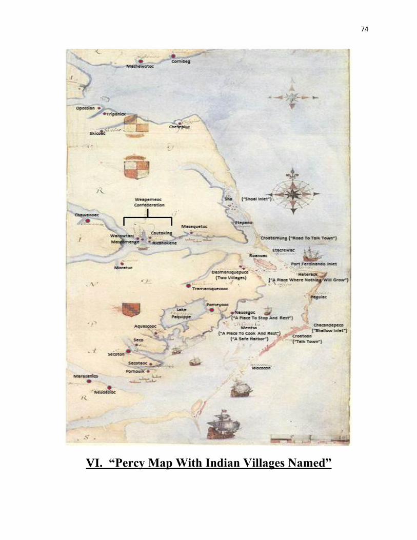
74
VI. “Percy Map With Indian Villages Named”
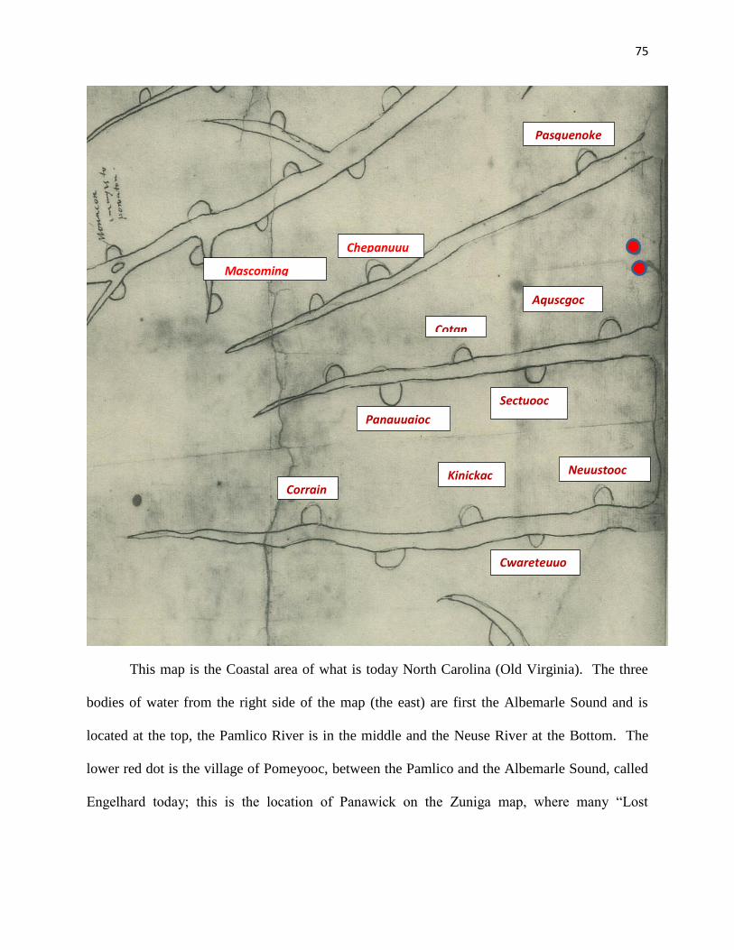
75
This map is the Coastal area of what is today North Carolina (Old Virginia). The three
bodies of water from the right side of the map (the east) are first the Albemarle Sound and is
located at the top, the Pamlico River is in the middle and the Neuse River at the Bottom. The
lower red dot is the village of Pomeyooc, between the Pamlico and the Albemarle Sound, called
Engelhard today; this is the location of Panawick on the Zuniga map, where many “Lost
Mascoming
↓
Chepanuuu
↓
Pasquenoke
↓
Aquscgoc
Sectuooc
Cotan
Panauuaioc
Neuustooc
Cwareteuuo
c
Kinickac Corrain
76
Colonist” are allegedly located. Far Creek is the body of water, and the Indian site of Pomeyooc
is clearly depicted and detailed as no other Indian village on this map.
The red dot located above it (to the northwest) is the location of the vanished Indian
Village of Tramanskecooc, drawn on the John White map of 1585, but after Thomas Harriot
published his Brief and True Report of The New Found Land of Virginia. In it he describes the
secret commodities that the 1585 colony discovered, but were kept a secret along with the
location, because reported individuals “not to the good of the action” would gain the large profits
that Sir Walter Raleigh and his investors did gain exporting sassafras back to England.
Moreover, this is also the location of the stone pile found by the Mason Lumber Company in the
1950s and, in addition, the location of the sassafras found by Ralph Lane’s Colony in 1585.
Many letters have recently been identified that have information about the new commodities
found in 1585, and the John Farrar Map published in 1650 was included for the first time in
Virgo Triumphans. Virgo was a seventy-six page book written entirely about the Ralph Lane
Colony, and many items in the publication are not found in any of the Roanoke Voyages
literature, including, but most importantly, the location of the sassafras on the map. Many
unreported voyages by the investors of the Roanoke Colonies are involved in reported failed
attempts to find the Colony.
77
VII. Thomas Harriot/Percy Relationship
Thomas Harriot induced Henry Percy (the Earl of Northumberland) into encouraging his
epileptic younger brother George to go out to Virginia in 1603. The Earl sent to his younger
brother clothes, books and papers. George Percy returned home in 1612. Christopher Newport
returned from Jamestown in 1609 with one of Powatan’s sons (this could have been the means of
the Zuniga map arriving back to England, and also Percy’s map if it was him who drew it.
Conjecture of other authors are one of the two men sent by Smith to contact the colonists at
Panowiok) (Fox, 2000: 43).
As Harriot lay dying he remembered his first patron Sir Walter Raleigh and desired that
the papers that he had of Raleigh’s should be burnt: “whereas I have divers _______ papers (of
which some are in a canvas bagge) of my accompts to Sir Walter Rawley for all which I have
discharges or acquitances lying in some boxes or other my desire is that they all be burnt---”
(Fox, 2000: 44-45).
78
VIII. “Chief Eyanoco and The Lost Colony”
1609: Strachey’s summary is very specific---“At Ritanoe (?), the weroance Eyanoco
(a.k.a. Gepanocon) preserved seven of the English alive, fower men, twoo Boyes, and one young
Maid, who eascaped and fled up the river of Choanoke, to beat his copper, of which he hath
certayn mines at the said Ritanoe, as also at Pannawaiack (Pananiok/Pomeyooc) are said to be
store of salt stones (Miller, 2000: 259)” (Miller, 2000: 236, 242 & 255).
This evidence, first presented by William Strachey, secretary of the Jamestown colony, is
the strongest evidence (to-date) of a splinter cell of the Lost Colony being settled. They were
purported to be located at Salmon Creek, which is based across from the Chowanoc River. This
was reinforced by the discovery of a stone there, which is believed to be a message from Eleanor
Dare. There is seemingly no way to scientifically confirm or disprove the Eleanor Dare Stone
(and its reported twin, the Turner Stone). The co-authors of the paper, however, strongly agree
that these two stones are possibly authentic.
79
IX. Ralph Lane Fortifications
Mosquito Bay, Puerto Rico
Ralph Lane gives us an idea of what the fort shape is like when he says: “What manner
of fort I would have I would have it a pentangle in this manner” (Quinn, 1955: 131-5, 403-5).
Cape Rojo, Puerto Rico
The main function of this fort was seizing captured Spanish salt mounds: “Lane
‘intrenched himself vpon the sandes immediately, compassing one of their salte hils within the
trench’” (Quinn, 1955: 131-5, 403-5, illustration beside 905).
Port Ferdinando
This fortification is the one referred to below as the “new fort in Virginia”. Lane also
says this inlet is the deepest in the Outer Banks, and that the fort is so strong the entire Spanish
fleet cannot pass by it (Quinn, 1955: 202; “Roanoke Sagas”, www.lost-colony.com).
North End Of Roanoke
This fort was long believed to be the main fortification at Roanoke described in a letter
by Ralph Lane as “a new fort in Virginia” (Quinn, 1955: 903-9). This fortification has since
fallen out of favor in that the main fortification is most probably on Shallowbag Bay in Doe’s
Creek, see below, and also not the one referred to in Lane’s letter.
Shallowbag Bay in Doe’s Creek, Manteo
Has been proffered as being the fort described by Pedro Diaz in the author’s paper
entitled “Roanoke Sagas” and a translation error found in the Spanish document of the deposition
of Pedro Diaz. Both can be found on the website www.lost-colony.com.
80
Point of Shallowbag Bay overlooking sound (not found yet)
John White’s narrative of 1590 indicates that there are still falcons (cannons) and small
ordinances left at this site (Quinn, 1955: 615).
Fortification at Salmon Creek in Bertie County (not found yet)
Thadd White, “Lost Colony Found?”, Roanoke-Chowan News Herald (Chapel Hill, NC:
May 3, 2012): http://www.roanoke-chowannewsherald.com/2012/05/03/lost-colony-found/
Fortification at Chowan River on west side (not found yet)
John Farrar, “A mapp of Virginia discovered to ye Hills, and in it’s Latt: From 35. deg.
& ½ neer Florida, to 41. deg. bounds of New England” (Collegit: Domina Virginia Farrar. Sold
by I. Stevenson at ye Sunne below Ludgate), 1651: http://www2.lib.virginia.edu/ exhibits/lewis_
clark/exploring/1maps/map6.jpg. This is the square fortress, the main fort, on the Farrar map.
Fortification at Little Alligator Creek on Alligator River, Fort Landing (not found yet)
John Farrar, “A mapp of Virginia discovered to ye Hills, and in it’s Latt: From 35. deg.
& ½ neer Florida, to 41. deg. bounds of New England” (Collegit: Domina Virginia Farrar. Sold
by I. Stevenson at ye Sunne below Ludgate), 1651: http://www2.lib.virginia.edu/ exhibits/lewis_
clark/exploring/1maps/map6.jpg. This is the circular fortress, the signal fort, depicted on the
Farrar map.
Indication of a propensity for Ralph Lane to build forts and may account for the fort on
the mouth of the Alligator River at Fort Landing, the fortification found under the patch on the
1585 map at Salmon Creek and possibly the fort found on the Farrar map at the Chowanock
Indian village (Quinn, 1955: 263).
81
X. Future Studies: Investors of the Roanoke Ventures
and The Lost Colony
Beyond the scope of this paper, it has become obvious that many voyages (at least 40)
were made to the coast of NE North America. This paper has documented that almost all of
these voyages are associated and partners with Sir Walter Raleigh, who had invested large sums
of money in the ventures and knew about the secret commodity of sassafras. Future studies to
expand this paper should involve investigating more thoroughly who the investors were, and
what their relationship was with Raleigh.
Please see the indicated names below, who on a surface-level examination have possible
ties to Raleigh’s Roanoke Ventures. In addition, all of them would have had a financial interest
in securing any profits from commodities or privateering against Spanish ships.
Queen Elizabeth I
Sir Francis Walsingham
Simon Fernandez
Sir Walter Raleigh
Lord Burghley
(Father of Cecil)
Sir Robert Cecil
John White
(Governor of 1587 Colony)
Sir Thomas Harriot
Lord Thomas Howard of Effingham
Sir Thomas Myddleton
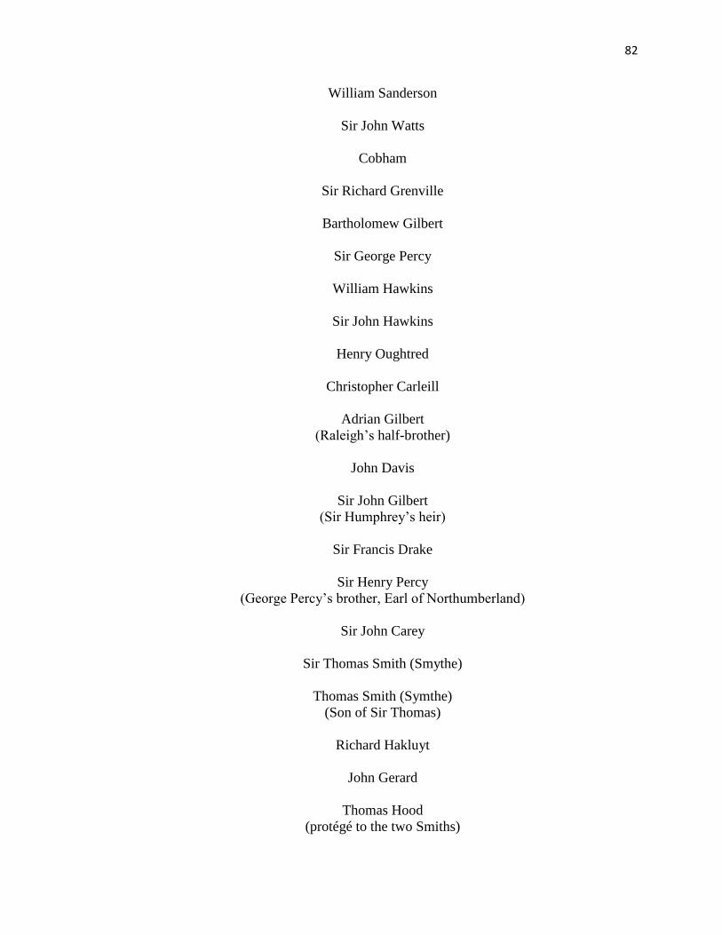
82
William Sanderson
Sir John Watts
Cobham
Sir Richard Grenville
Bartholomew Gilbert
Sir George Percy
William Hawkins
Sir John Hawkins
Henry Oughtred
Christopher Carleill
Adrian Gilbert
(Raleigh’s half-brother)
John Davis
Sir John Gilbert
(Sir Humphrey’s heir)
Sir Francis Drake
Sir Henry Percy
(George Percy’s brother, Earl of Northumberland)
Sir John Carey
Sir Thomas Smith (Smythe)
Thomas Smith (Symthe)
(Son of Sir Thomas)
Richard Hakluyt
John Gerard
Thomas Hood
(protégé to the two Smiths)
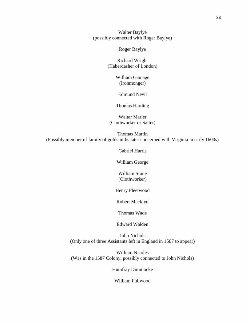
83
Walter Baylye
(possibly connected with Roger Baylye)
Roger Baylye
Richard Wright
(Haberdasher of London)
William Gamage
(Ironmonger)
Edmund Nevil
Thomas Harding
Walter Marler
(Clothworker or Salter)
Thomas Martin
(Possibly member of family of goldsmiths later concerned with Virginia in early 1600s)
Gabriel Harris
William George
William Stone
(Clothworker)
Henry Fleetwood
Robert Macklyn
Thomas Wade
Edward Walden
John Nichols
(Only one of three Assistants left in England in 1587 to appear)
William Nicoles
(Was in the 1587 Colony, possibly connected to John Nichols)
Humfray Dimmocke
William Fullwood
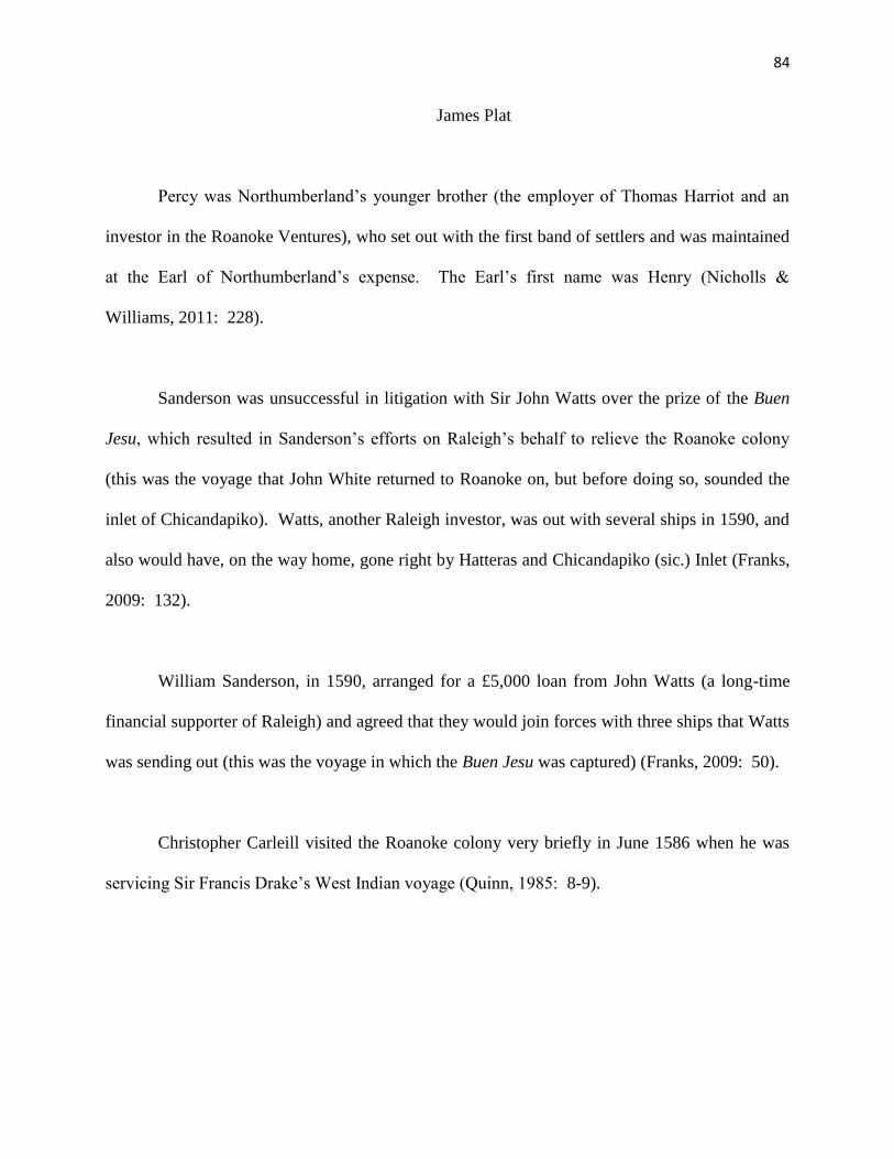
84
James Plat
Percy was Northumberland’s younger brother (the employer of Thomas Harriot and an
investor in the Roanoke Ventures), who set out with the first band of settlers and was maintained
at the Earl of Northumberland’s expense. The Earl’s first name was Henry (Nicholls &
Williams, 2011: 228).
Sanderson was unsuccessful in litigation with Sir John Watts over the prize of the Buen
Jesu, which resulted in Sanderson’s efforts on Raleigh’s behalf to relieve the Roanoke colony
(this was the voyage that John White returned to Roanoke on, but before doing so, sounded the
inlet of Chicandapiko). Watts, another Raleigh investor, was out with several ships in 1590, and
also would have, on the way home, gone right by Hatteras and Chicandapiko (sic.) Inlet (Franks,
2009: 132).
William Sanderson, in 1590, arranged for a £5,000 loan from John Watts (a long-time
financial supporter of Raleigh) and agreed that they would join forces with three ships that Watts
was sending out (this was the voyage in which the Buen Jesu was captured) (Franks, 2009: 50).
Christopher Carleill visited the Roanoke colony very briefly in June 1586 when he was
servicing Sir Francis Drake’s West Indian voyage (Quinn, 1985: 8-9).
85
Assessment of the Paradigm Argument That the Long-Held Belief That the Colony
Moved to Chesapeake Bay
A. Introduction
The research presented in this appendix is an attempt to categorize, dissect, and
assimilate all the bits of information about the Lost Colony---scattered like breadcrumbs---into a
format that locates the destination of the colonist. Of the many theories developed about what
happened to them, only four or five are now considered valid. The evidence compiled by the co-
authors of this paper and listed below, strongly suggests all remaining evidence points to one
location: the Beechland region (Hyde, Tyrell, & Dare Co. and the Pungo/Alligator River area),
which from 400 years ago to today can only be accessed by small watercraft. The following are
the breadcrumbs or clues that the co-authors have accumulated.
B. Clues that the Chesapeake was not their destination
In his narrative of the 1587 voyage, Governor John White wrote that the colonists’
destination was Chesapeake Bay, but he said they were forced by Simon Ferdinand to remain on
Roanoke Island. Because his narrative was published shortly after his return, this may have been
an attempt to conceal his true destination from the Spanish and from those who might try to find
the source of Raleigh’s valuable sassafras:
1. Stephen B. Weeks questioned John White’s claim that Simon Ferdinando, in addition
to other treacheries, forced the colonists to remain on Roanoke Island when their
intended destination was Chesapeake.37 Weeks offered with a litany of Ferdinando’s
(many spellings) services to England, then wrote: Walsingham, in his letter of August
12, 1585, speaks of Ferdinando in the highest terms, even considering him worthy to
be commemorated in the inlet which was the ‘beste harborough of all the reste,’ and
37 Weeks, 17
86
it is not probable that a long period of service would have been closed with an act of
treachery.” After reading Weeks, one must ask why White would make such a
slanderous and blatant lie about Ferdinando, when his performance record---not to
mention Ferdinando boss, Walsingham---clearly states this is not true.
2. When Governor White arrived off Roanoke Island, he said he boarded the pinnace
only to confer with the 15 men left on the island by Sir Richard Grenville. As he left
in the pinnace, “a Gentleman by the meanes of Fernando, who was appointed to
returne for England, called to the sailers in the pinnesse, charging them not to bring
any of the planters backe againe, but leave them in the Island.”38 White was
“accompanied with fortie of his best men.” The 40 men with White seems more than
necessary if he only planned a brief visit with the 15 men.
3. Fernando’s excuse for not going on to Chesapeake was that, “the Summer was farre
spent, wherefore hee would land all the planters in no other place.”39 Despite his
apparent haste to depart, he did not leave until White was ready to return to England,
and he accompanied Whites ‘Flie Boat’ east in his Admiral’s ship. From his arrival at
Roanoke Island on July 22, 1587, Fernando remained in the service of Governor John
White until September 17, 1587, -- almost two month -- before breaking off to hunt
Spanish ships near Flores Island.
4. White stated twice that the colonist had no intention of remaining on Roanoke Island.
In his 1587 narrative he wrote, “Also he (John White) alleaged, that seing they
intended to remoue 50. miles further vp into the maine presently, he (John White)
being then absent, his stuff and goods, might be both spoiled, and most of it pilfered
away…”40 He confirmed this intent in his 1590 narrative “…for at my coming away
they were prepared to remoue from Roanoke 50 miles into the maine”41
38 White 1587: 97 39 Ibid. 40 Quinn, 1955: 533-534 41 Quinn, 1955: 613 .
87
5. The colonists clearly intended to build a new ‘City’ in their new location because they
dismantled and took with them all of their houses. White wrote: “. . . they were left in
sundry houses, but we found the houses taken downe.”42
C. Clues that the Croatan/Hatteras Indians allied with the colonists
It was well established in the Roanoke Voyage narratives that Manteo and the Croatan
Indians of were close allies of the 1587 colonists. As shown in the text, Steven B. Weeks first
documented that the Croatan were in control of a vast territory between the Albemarle and the
Pamlico Sounds after they supplanted the Secotan Confederation. There is ample evidence that
the 1587 colonist and the Croatan were allies and had villages on the Alligator:
1. At Sir Walter Raleigh’s request a ceremony took place, proclaiming Manteo “Great
Lord and Chief of Dasemunkepeuc” (many variant spellings) on the 31st of August
1587. 43 This enabled Manteo to have supreme authority over all the Indians in the
area and over 4 million acres of land. It also protected the location of Raleigh’s secret
commodities. (See Farrar map indicating sassafras, English forts, and
Dasmansquepuce.)
2. Although it has now become evident, scholars have totally missed that the once-
powerful Secotan Confederacy was completely supplanted by the small Croatan Indian
tribe. It is very doubtful that the Croatan could have achieved this feat without a
partnership with the English. The documentation that this did occur can be found on
the maps on Pages 10, 11, and 27-29 of “Spies & Lies” at the Lost Colony Center web
site.
3. One of the more significant recent discoveries relating to this research is an Indian
village depicted on the Alligator River on early maps. IKONOS imaging has located
three sites as possible locations for the colonists to have settled with the Croatan, and
all three have been identified and confirmed as Indian village sites (and located on
many of the 16th- and 17th-century maps along the Alligator). The IKONOS image
42 White 1590: 126 43 Quinn, 1955: 504-5, 531 .
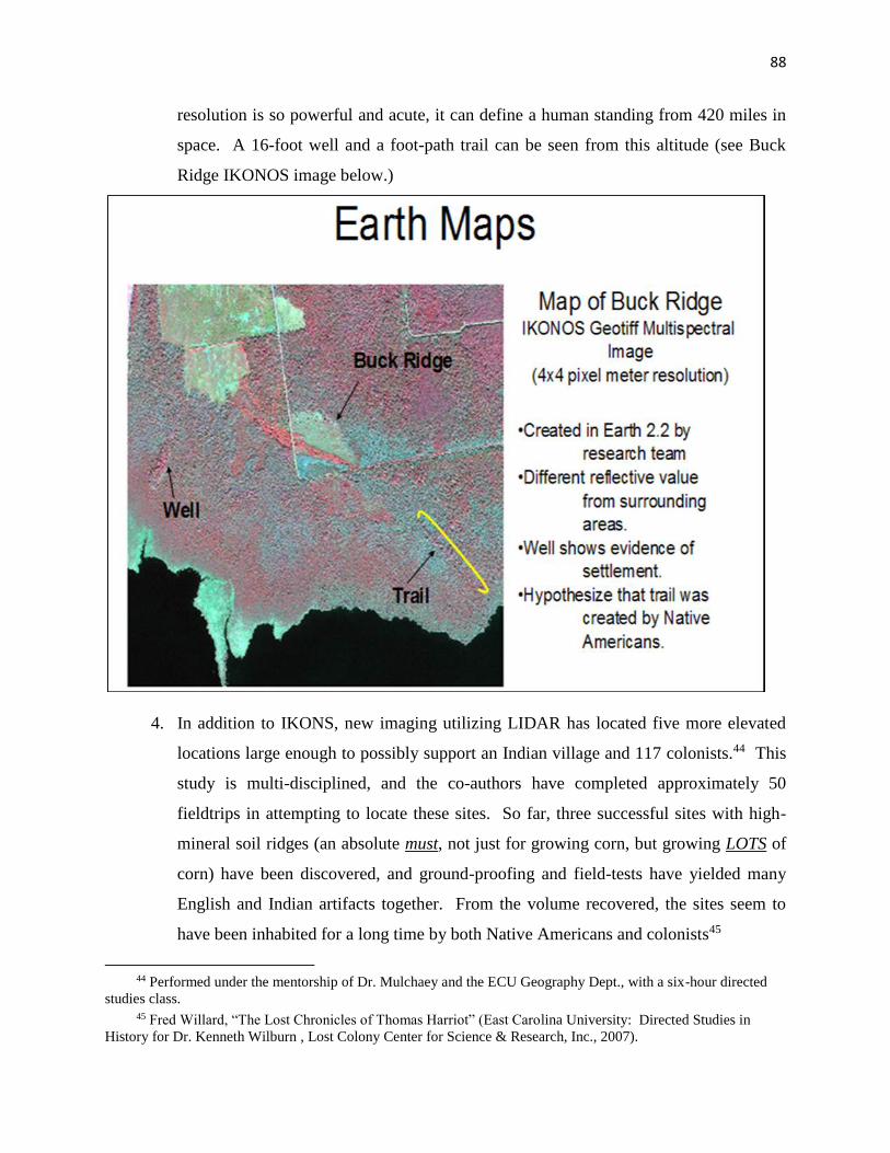
88
resolution is so powerful and acute, it can define a human standing from 420 miles in
space. A 16-foot well and a foot-path trail can be seen from this altitude (see Buck
Ridge IKONOS image below.)
4. In addition to IKONS, new imaging utilizing LIDAR has located five more elevated
locations large enough to possibly support an Indian village and 117 colonists.44 This
study is multi-disciplined, and the co-authors have completed approximately 50
fieldtrips in attempting to locate these sites. So far, three successful sites with high-
mineral soil ridges (an absolute must, not just for growing corn, but growing LOTS of
corn) have been discovered, and ground-proofing and field-tests have yielded many
English and Indian artifacts together. From the volume recovered, the sites seem to
have been inhabited for a long time by both Native Americans and colonists45
44 Performed under the mentorship of Dr. Mulchaey and the ECU Geography Dept., with a six-hour directed
studies class. 45 Fred Willard, “The Lost Chronicles of Thomas Harriot” (East Carolina University: Directed Studies in
History for Dr. Kenneth Wilburn , Lost Colony Center for Science & Research, Inc., 2007).

89
Other clues show that the Croatan/Hatteras Indians and the descendants of the colonists
continued to live together long after the colonists lost contact with England.
5. The notations found on the Zuniga map only 30 years after the colony was lost are the
most important clues concerning the Lost Colony of 1587. Although the notations
support the co-authors’ hypothesis, the rough-drawn sketch map lacks definitive
locations of the Indian villages because the map is not drawn to scale. This problem
may have been resolved with the discoveries of the Farrar and Percy maps because
they more accurately determine the location of Pomeyooc village (a.k.a. “Pananiock”
or “Panawiki”).
6. According to author James Sprunt, the Coree Indians informed the Barbados colony at
Cape Fear in 1654 that the Lost Colony had survived and were living with Hatteras
Indians at Croatan. After their Cape Fear colony foundered, they re-established their
Barbados-related colony on the north shore of the Albemarle River and intermarried
with the Hatteras Indians.46 [Needs a reference.]
7. This coincides with John Lawson’s report that these Indians dressed as English, and in
the margin of his report wrote “Hatteras Indians.”47
8. Lawson’s accounts of the native populations are more detailed and are the best early
records yet found to-date. He reports that the Paspitank (sic) Indians did formally
keep cattle and make butter. He also made a profound statement relating specifically
to the culture, manners and dress of these Indians, and furthermore, that they are
different from all other natives he has encountered: “The dresses of these people are
so different, according to the Nation that they belong to. . .” “. . .which wear Hats,
Shooes, Stockings, and Breeches, with very tolerable Linnen Shirts, which is not
common amongst these. . .”48
46 Need a reference here. 47 Lawson, 200-20 . 48 Native Americans (Fred L. Willard, “The Machapungo Indians and the Barbados Connection 1663 to 1840”,
East Carolina University: Directed Studies in History for Dr. Angela Thompson, http://www.lost-colony.com/
currentresearch.html, Lost Colony Center for Science & Research, Inc., 2008” citing Lawson, 1967: 200-1).
90
9. There is an Appleton Magazine article about a priest in 1660 who preached to white
Indians on the Pantego River who could speak English: “In 1660 the Rev. Morgan
Jones, of Virginia, was captured by the Tuscarora Indians living in North Carolina
along the Neuse River. After some time in captivity he returned civilization to make
the solemn statement that he had found a tribe settled on the Pantego River, near Cape
Atros (Hatteras), known to their neighbors as the white Indians on account of their
light color; he tells that they spoke British, in which language he preached to them
three times a week.” [Needs a reference.]
D. Clues that the colonists went inland secretly to harvest sassafras
The co-author’s hypothesis leans heavily on evidence that sassafras was a major
commodity shipped frequently from the Virginia to England. Their hypothesis states that the
colonists, on Raleigh’s instruction, traveled by water with the Croatan to the lower end of the
Alligator River, where they found sassafras near the village of Tramanskecooc in the Beechland
area. The most importance evidence that there was sassafras near Tramanskecooc was found in
the Farrar map.
1. William Cummings reports that John Farrar, mapmaker, had access to papers, reports,
and information that were not available to others, and also that Farrar commissioned
Williams to write Virgo Triumphans, and all the information about the 1585 Roanoke
voyage was obtained from him.49
2. On the map that was in Virgo Triumpans is a sassafras tree (at the location of the
Tramansquecooc Indian village on the White 1585 map) and two English fortifications
located at Fort Landing and near the Chowanoc Indian village. Farrar clearly depicts a
sassafras tree in this one location, and no other trees are identified. The co-authors
believe that Farrar had access to documents from Thomas Harriot’s lost Chronicles
pertaining to the area in question.
49 Cummings, 1998: 148 .
91
3. Discovery of the Percy map, and comparing it with the Zuniga, White and Farrar maps
shows that the possible location of Pomeyooc and Tramansquekooc is forthcoming. How
every Indian village in North Carolina is named helps to identify locations on the map.
The authors contend that Sir Walter Raleigh purposely tried to hide the knowledge that
his men had discovered sassafras in Virginia. We have obtained some specific evidence of the
classification of sassafras as a ‘secret commodity’ in the Roanoke Voyage narratives.
4. Richard Hakluyt to Sir Walter Raleigh letter in 1587: “One of your followers knows
about the ‘certain secret commodities’ already discovered by your servants.”50
5. Letter of Ralph Lane to Richard Hakluyt, 1585: “And we have found rich commodities
and apothecaries and drugs.”51
6. In A Brief and True Report, Thomas Harriot mentions secret commodities, but he would
not divulge their location to those who did not wish him well: “Two more commodities of
great value one of certaintie, and the other in hope, not to be planted, but there to be
raised & in a short time to be provided and prepared, I might have specified. So like
wise of those commodities already set downe I might have said more; as of the particular
places where they are founde ----; But because others then welwillers might bee
therewithall acquainted, not to the good of the action, I haue wittingly ommited them:
knowing that to those that are well dsposed I have uttered, according to my promise and
purpose, for this part sufficient.”52
7. Mysteriously” Tramaskecooc village was removed almost immediately from the map
after the publication of Thomas Harriot’s Brief and True Report.53
E. Clues that the colonists exported sassafras to England
Ample evidence has also been found that sassafras was exported to England. Our
assumption is that it was first moved to Croatoan village near Chacandapeco Inlet (Cape
50 Quinn, 1955: 545, 548-9 . 51 Quinn, 1955: 207-9, 336-7 . 52 Harriot/Hulton, Brief and True Report: 12; Quinn, 1955: 314 . 53 see Quinn: White 1585 Manuscript B vis a vi White-DeBry 1590 .
92
Hatteras) where English sailors would transfer it to their ships. These shipments occurred while
Sir Walter Raleigh’s Royal Charter allowed him to control all commodities shipping from
Virginia, including sassafras.
From 1588 to 1605 at least 60 ships were sent out under Raleigh’s command or by
investors in the Roanoke Colony. This hard, indisputable clue has been documented with words,
papers and articles written by many scholars over centuries of research---and has also not been
detailed before now. The voyages that are known to have reached the Outer Banks and returned
with sassafras follow.
1. The ship’s log of the Primrose, one of Drake’s ships that relieved the 1585 colony, has
notations that there are large amounts of sassafras stored in the hold to take back to
England, and that sassafras was the most valuable commodity in all of North America.54
2. From 1600 to 1605 Samuel Mace is documented on five voyages to find the Lost Colony,
and to trade copper for sassafras. He claimed he landed south of Roanoke and had to turn
back every time because of “foul weather.”
3. Captain Martin Pring was sent in ships to find sassafras in 1603 “On April 10, 1603, a
Captain Martin Pring, in command of the Speedwell and Discoverer, sailed to North
America and returned with their holds full of sassafras. Interestingly, they were reported
to have landed far north of Roanoke Island, but at the same time, many accounts that Sir
Walter Raleigh’s colony had again been contacted were reported from several sources.”55
4. In a deposition after being captured by the Spanish, David Glavin reported that Richard
Hawkins, when captured, was attempting to obtain sassafras in 1595-6.56. While in the
hands of the Spanish at St. Augustine, Glavin claimed two additional ships were
provisioned to go to Jacan (Roanoke Island) in 1599, carrying supplies of people,
ammunition, clothes, implements, axes and spades for the settlers there.
54 Quinn, 1955: 35, 303-8 . 55 Miller: 207-8: 56 Miller: 207-8; and also Quinn, 1955: 834
93
5. John Brereton in a paper to Sir Walter Raleigh, 1594: “A company of men manned a new
ship and were paid weekly wages to ensure they would not go after ships for plunder, and
they are to secure sassafras and instructed to seek out the 1587 colony”57
6. In 1605 two ships, the Castor and the Pollux, again are sent to Croatan and instructed to
get sassafras. But the Castor and Pollux were captured by the Spanish.58
7. An important events that has been previously overlooked is that the John White’ ships
landed off Croatan on August 12, 1590. The next day, the boats sounded the inlet, but
John White gave not indication of their prupose.59. It is proffered by the co-authors that
White’s interest in this inlet is for the exportation of sassafras from Pomeyooc.
8. The Croatan site has produced thirty to forty thousand artifacts; some of the most
significant English artifacts have been dated to the time of the Roanoke Voyages. It
should be noted that the inlet at Croatan is due east of Pomeyooc, which would be the
natural route for exportation of any commodities, and because of White’s sounding, the
co-authors believe it was sassafras being shipped to England.60
9. But if, in solving the mystery of the Lost Colony to its conclusion, a smoking gun was
ever needed, the book Rariorum plantorium listeria and the report of a consignment of
sassafras in 1603 from Raleigh to Nurnberg are it. These two documents are the most
important confirmation that Sir Walter Raleigh and his investors were aggressively
importing sassafras into England, and that the location of the sassafras was Raleigh’s
“lost” city.
10. Consignment of Sassafras in 1603 from Raleigh to Nurnberg: On September 10, 1603:
Sir William Waad, Clerk of the Privy Council wrote to Cecil, enclosing a letter which had
been intercepted on its way to Raleigh, who had been arrested on July 15th for treason.
Information in it indicated that some of Raleigh’s American sassafras, consigned to
57 Miller, 2000: 207-8 . 58 Phil Jones, Raleigh’s Pirate Colony in America: The Lost Settlement of Roanoke 1594-90 (Charleston, SC:
Tempus Publishing Co.), 2001: 101-2). 59 Quinn, The First Colonists (Raleigh, NC: Department of Cultural Resources, Division of Archives &
History), 1982: 123) 60 see Goodlow, “Trash Will Tell Very Tall Tale” and Jim Morrison, “In Search of the Lost Colony”,
American Archaeology, Vol. 10, No. 4 (Maryland: Archaeological Conservancy Quarterly Publication (Eastern
Region)), Winter 2006-2007: 38-44, http://lost-colony.com/magazineAA.html).
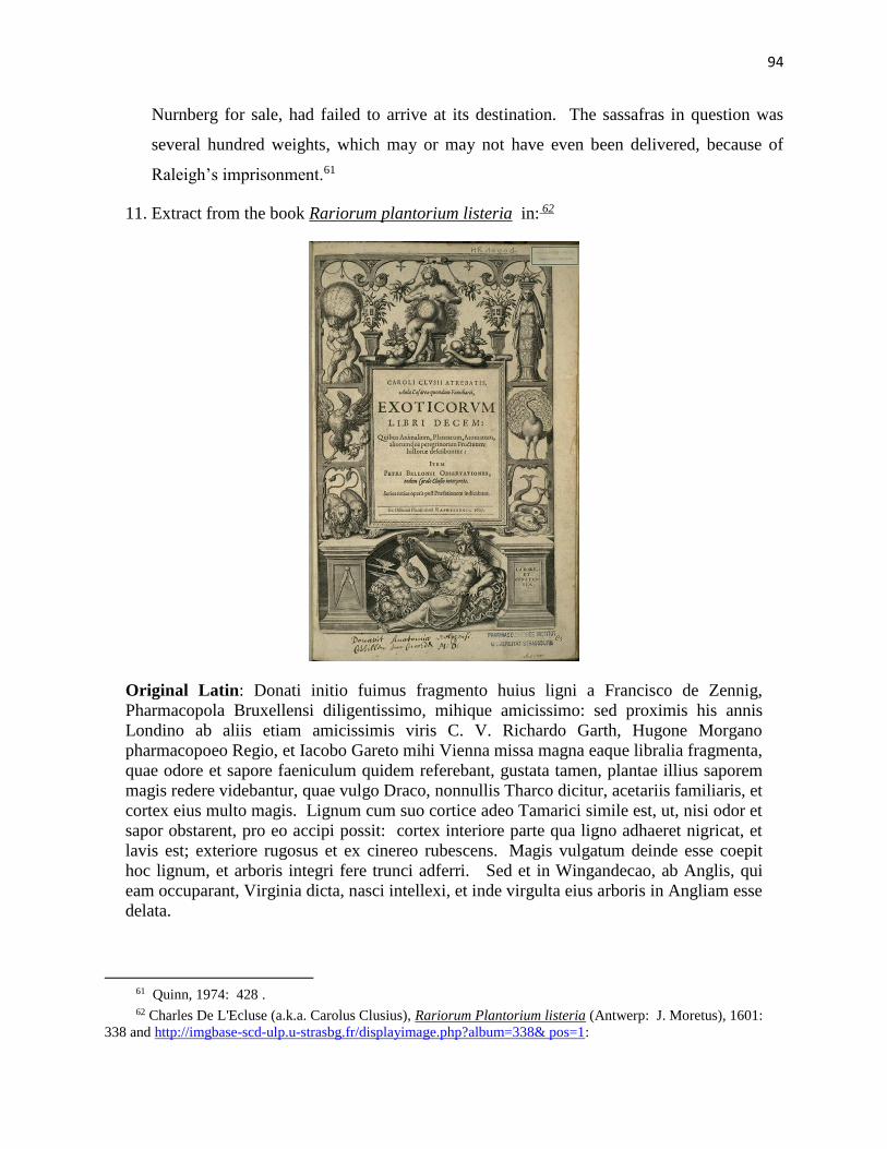
94
Nurnberg for sale, had failed to arrive at its destination. The sassafras in question was
several hundred weights, which may or may not have even been delivered, because of
Raleigh’s imprisonment.61
11. Extract from the book Rariorum plantorium listeria in: 62
Original Latin: Donati initio fuimus fragmento huius ligni a Francisco de Zennig,
Pharmacopola Bruxellensi diligentissimo, mihique amicissimo: sed proximis his annis
Londino ab aliis etiam amicissimis viris C. V. Richardo Garth, Hugone Morgano
pharmacopoeo Regio, et Iacobo Gareto mihi Vienna missa magna eaque libralia fragmenta,
quae odore et sapore faeniculum quidem referebant, gustata tamen, plantae illius saporem
magis redere videbantur, quae vulgo Draco, nonnullis Tharco dicitur, acetariis familiaris, et
cortex eius multo magis. Lignum cum suo cortice adeo Tamarici simile est, ut, nisi odor et
sapor obstarent, pro eo accipi possit: cortex interiore parte qua ligno adhaeret nigricat, et
lavis est; exteriore rugosus et ex cinereo rubescens. Magis vulgatum deinde esse coepit
hoc lignum, et arboris integri fere trunci adferri. Sed et in Wingandecao, ab Anglis, qui
eam occuparant, Virginia dicta, nasci intellexi, et inde virgulta eius arboris in Angliam esse
delata.
61 Quinn, 1974: 428 . 62 Charles De L'Ecluse (a.k.a. Carolus Clusius), Rariorum Plantorium listeria (Antwerp: J. Moretus), 1601:
338 and http://imgbase-scd-ulp.u-strasbg.fr/displayimage.php?album=338& pos=1:
95
English Translation:63
At first we were given a fragment of this wood by Franciscus de Zennig, a most diligent
pharmacist in Brussels, and a very good friend of mine. But in the past few years, large
fragments were sent from London by other dear friends, C. V. Richard Garth, Hugo
Morgan the royal pharmacist, and Jacob Garet, to me in Vienna, and these fragments were
by the pound. Their smell and flavor indeed resembled fennel; once tasted however, they
seemed to give a flavor more of that plant commonly called Draco (Dracaena?), known to
some as Tharco (?), known to makers of vinegar (acids?), and much more its bark. The
wood with its bark is so similar to Tamarisk that if its smell and flavor didn’t prevent it, it
could be taken for it. Its bark is blackish on the inside where it adheres to the wood, and is
lavis (washed out? washable?). On the exterior, it is wrinkled and turns red from ash
(when burned?). This wood has begun to be more common then, and to be brought as
almost entire tree trunks. But I have learned that it also grows in Wingandecao, called
Virginia by the English, who occupy it, and that from there, the boughs of this tree have
been brought to England.
Bibliography
Andrews, Kenneth R. Trade, Plunder and Settlement: Maritime Enterprise and the Genesis of
the British Empire, 1480-1630. Cambridge: Cambridge University Press. 1984
Anonymous. “A Description of the Land of Virginia”. Colonial Papers, Vol. 1, No. 42,-II.
1585. http://www.she-philosopher.com/images/gallery/exhibits/smithMSmap(6280x4100).jpg
Barbour, Philip L. The Jamestown Voyages Under the First Charter, 1606–1609, 2 vols.
Publications of the Hakluyt Society, ser.2, 136–37. Cambridge: Cambridge University Press.
1969
63 Personal Correspondence, Dr. John Stevens, May 26, 2011
96
Brown, Alexander. Genesis of the United States: a narrative of the movement in England,
1605-1616, which resulted in the plantation of North America by Englishmen, disclosing the
contest between England and Spain for the possession of the soil now occupied by the United
States of America. 2 Vols. Boston, New York: Houghton, Mifflin, and Co. 1890
Campbell, Tony. Early Maps. New York: Abbeville Press, Incorporated. 1981
Canço, Gonçalo Mendez de. “Report of David Glavin, Irlandes, Soldado”, recorded by Canço
and forwarded to Philip III of Spain, February 1600, printed in Documentos Históricos de la
Florida y la Luisiana, siglos XVI al XVIII, ed. Manuel Serrano y Sanz. Madrid: Libería
General De Victoriano Suárez. 1913
Corbett, J.S. The Spanish War 1585-1587. Great Britain: Navy Records Society. 1898
Cummings, William P. The Southeast in Early Maps, 3rd Edition. Chapel Hill: University of
North Carolina Press. 1998
De L'Ecluse, Charles (a.k.a. Carolus Clusius). Rariorum Plantorium listeria. Antwerp: J.
Moretus. 1601. http://imgbase-scd-ulp.u-strasbg.fr/displayimage.php?album=338&pos=1
DeBry, Theodore and John White. “Americae pars, Nunc Virginia dicta, primum ab Anglis
inuenta sumtibus Dn. Walteri Raleigh, Equestris ordinis Viri. . . MDLXXXV . . . ”. Germany:
Admiranda Narratio fida tamen, de Commodis et Incolarum Ritibus Virginiae (Frankfurt). 1590.
http://www.raremaps.com/gallery/detail/22983?view=print
“DNA Project, Croatan Indians, Sir Walter Raleigh”. http://ww.lost-colony.com
Edwards, Edward. The Life of Sir Walter Raleigh: Based on Contemporary Documents
Preserved in the Rolls House, the Privy Council Office, Hatfield House, the British Museum, and
Other Manuscript Repositories, British and Foreign. Together With His Letters Now First
Collected, Vol. 2 - Letters. London: Macmillan and Co. 1868
Farrar, John. “A mapp of Virginia discovered to ye Hills, and in it’s Latt: From 35. deg. & ½
neer Florida, to 41. deg. bounds of New England”. Collegit: Domina Virginia Farrar. Sold by I.
Stevenson at ye Sunne below Ludgate. 1651. University of Virginia Library:
http://www2.lib.virginia.edu/ exhibits/lewis clark/exploring/1maps/map6.jpg
Ford, Alexander Hume. “The Finding of Raleigh’s Lost Colony”. Appleton’s Magaine.
Location: The Library of the University of North Carolina at Chapel Hill. Department: The
Collection of North Carolina. Registration #: Cp970.03,F69f. ID #: 00032198381. July 1907.
http://archive.org/stream/findingofraleigh00ford#page/30/mode/2up
Fox, Robert. Thomas Harriot: An Elizabethan Man of Science. Burlington, Vermont: Ashgate
Publications. 2000
97
Franks, Michael. The Court, the Atlantic and the City: Sir Walter Raleigh V. William Sanderson
With A Foreword by Mr. John Digby of Sherborne Castle. Great Britain: South and West
Books. 2009
Gibbs, Marco. Personal communication with Fred Willard. 2002-2012
Goodlow, Mary Hellen. “Trash Will Tell Very Tall Tale”. The Coastland Times. Manteo, NC.
July 31, 1994. www.lost-colony.com/Buxtonfind.html
Harris, Morgan H. Hyde Yesterdays: A History of Hyde County. Wilmington: New Hanover
Printing & Publishing, Inc. 1995
Harriot, Thomas. A Briefe and True Report of the New Found Land of Virginia: The Complete
1590 Theodor de Bry Edition. Edited by Paul Hulton. New York: Dover Publications. 1972
Hulton, Paul. America 1585: The Complete Drawings of John White. Chapel Hill: University
of North Carolina Press. 1984
Johnson, Roy F. Algonquins, the Indians of the Part of the New World First Visited by the
English: Prehistory-Culture. Wilmington, NC: Broadfoot Publishing Company. 1972
Jones, Phil. Raleigh’s Pirate Colony in America: The Lost Settlement of Roanoke 1594-90.
Charleston, SC: Tempus Publishing Co. 2001
Kozak, Catherine. “At 75, Historian Still Hits the Books in College”. The Virginian-Pilot.
Hampton Roads, VA. June 5, 2006
Kozak, Catherine. “Buxton Crew Digs Up Possible Lost Colony Link”. The Virginian-Pilot.
Hampton Roads, VA. October 14, 1998
Kozak, Catherine. “ECSU (Elizabeth City State University) Researchers Go High-Tech in Old
Search”. The Virginian-Pilot. Hampton Roads, VA. March 6, 2005
Kozak, Catherine. “New Hints to Lost Colonists Found”. The Virginian-Pilot. Hampton Roads,
VA. March 31, 2001
Kozak, Catherine. “Old Account May Yield New Clues to Lost Colony”. The Virginian-Pilot.
Hampton Roads, VA. February 3, 2005
Kozak, Catherine. “Paper Linking Croatan Indians, the Lost Colony Garners Awards”. The
Virginian-Pilot. Hampton Roads, VA. April 29, 2003
Kozak, Catherine. “Seeking the Lost Colony”. The Virginian-Pilot. Hampton Roads, VA. July
2, 2006
Kozak, Catherine. “Team Hopes DNA is Clue to Lost Colony Mystery”. The Virginian-Pilot.
Hampton Roads, VA. June 11, 2007.
98
Kozak, Catherine. “Team Plans to Resurrect Excavations at Croatan Site”. The Virginian-Pilot.
Hampton Roads, VA. November 1, 2005
Kraus, H. P. “Virginia (The Percy Map)”. Monumenta Cartographica. Cat. 124, no. 28. Originally
drawn by Sir George Percy or Nathan Powell. New York: Kraus Publications. 1969
Lathan, Agnes Mary Christabel. “Sir Walter Raleigh’s Farewell Letter To His Wife In 1603: A
Question of Authenticity”. Essays and Studies #25. London: English Association. 1939
LaVere, Dr. David. Personal communication with Fred Willard. July 2012
Lawson, John D. A New Voyage To Carolina. Edited with an Introduction and Notes by Hugh
Talmage Lefler. Chapel Hill: University of North Carolina Press. Reprint edition 1967.
Original title & publication: A New Voyage to Carolina; Containing the Exact Description and
Natural History of That Country: Together with the Present State Thereof. And a Journal of a
Thousand Miles, Travel'd Thro' Several Nations of Indians. Giving a Particular Account of Their
Customs, Manners, &c. London: [s.n.], 1709
Lewis, Clifford M. & Albert J. Loomie. The Spanish Jesuit Mission in Virginia, 1570-1572.
Chapel Hill: University of North Carolina Press. 1953
Long, Mary Wood. The Five Lost Colonies. Elizabeth City: Family Research Center. 2000
Mr. Mason’s brother. Personal communication with Fred Willard. 1998
McMullan, Philip. “A Role for Sassafras in the Search for the Lost Colony”.
http://www.lost-colony.com/currentresearch.html. Lost Colony Center for Science and
Research. 2006.
McMullan, Philip. “A Search For The Lost Colony In Beechland”. Lost Colony Center for
Science & Research, http://www.lost-colony.com/currentresearch.html. Northeastern NC
Development. 2002
McMullan, Phil. “Beechland & The Lost Colony”. A thesis submitted to the Graduate Faculty
of North Carolina State University in partial fulfillment of the requirements for the Degree of
Master of Arts. History Department: Dr. Holly Brewer. 2010
Miller, Lee. Roanoke: Solving The Mystery Of The Lost Colony. New York: Arcade
Publishing. 2000
Miller, Lee. Roanoke: The Mystery Of The Lost Colony. New York: Scholastic Nonfiction.
2007
Minster, Christopher. “Sir Walter Raleigh's Second Journey to El Dorado”:
http://latinamericanhistory.about.com/od/latinamericatheconquest/p/Sir-Walter-Raleigh-S-
Second-Journey-To-El-Dorado.htm
99
Morden, Robert, Philip Lea, John Thorton, and George Willdey. “A New Map of Carolina”.
London: ye Atlas in Corn-hill (Morden), the Atlas & Hercules in the Poultry (Lea), the Platt in
the Minories (Thorton), and the Great Toy, Spectacle, China-ware, and Print Shop, ye corner of
Ludgate Street near St. Paul’s (Willdey). 1688. www.cummingmapsociety.org/17thC_Maps.
htm
Morrison, Jim. “In Search of the Lost Colony”. American Archaeology, Vol. 10, No. 4.
Maryland: Archaeological Conservancy Quarterly Publication (Eastern Region). Winter 2006-
2007. http://lost-colony.com/magazineAA.html
Moseley, Edward. “A New and Correct Map of the Province of North Carolina.” London: Sold
at the Three Crowns. Joyner Library of East Carolina University: Special Collections
Department. 1733. http://digital.lib.ecu.edu/1028
“Overwhelming Response To DNA Project Symposium”. http://ww.lost-colony.com
Pool, Ralph. “‘Lost Colony Wasn’t’ Old Tradition Says”. Hampton Roads, VA: The Virginia-
Pilot. July 3, 1960
Quinn, David Beers. England and the Discovery of America 1481-1620. London: George Allen
and Unwin, Ltd. 1974
Quinn, David Beers. Set Fair For Roanoke. Chapel Hill: The University of North Carolina
Press, America’s 400th Anniversary Committee. 1985
Quinn, David Beers. The First Colonists. Raleigh, NC: Department of Cultural Resources,
Division of Archives & History. 1982
Quinn, David Beers. The Roanoke Voyages. 2 Vols. New York: Dover Publications. 1955
Quinn, David B. and Allison M. Quinn, eds. The First Colonists: Document on the Planning of
the First English Settlements in North America 1584-1590. Raleigh: North Carolina Department
of Cultural Resources, Division of Archives and History. 1982
Rountree, Helen. The Powhatan Indians of Virginia. Oklahoma: The University Press of
Oklahoma. 1989
Rountree, Helen. Powhatan’s People. Oklahoma: The University Press of Oklahoma. 1990
Scott, Dr. Ralph. Personal communication with Fred Willard. May 2012
Smith, John. A True Relation of Such Occurrences and Accidents of Note as Hath Hapned in
Virginia Since the First Planting of that Colony, which is now resident in the South part
thereof, till the last returne from thence. Written by Captaine Smith, one of the said
100
Collony, to a worshipfull friend of his in England. London: Printed for John Tappe, and are
to bee solde at the Greyhound in Paules-Church yard, by W.W. 1608
Speck, Frank G. “Remnants of the Machapunga Indians of North Carolina”. American
Anthropologist Vol. 18, No. #2. Arlington, VA: American Anthropological Association. April-
June 1916
Speed, John, John Ogilby & James Joseph Moxon. “A New Description of Carolina”. The
Theatre of the Empire of Great Britain: The Prospect of the Most Famous Parts of the World.
London: Sold by Tho. Basset in Fleet Street and Ric. Chiswell in St. Paul’s Churchyard. 1676.
http://www.geographicus.com/P/AntiqueMap/Carolina-speed-1676
Sprunt, James. Tales and Traditions of the Lower Cape Fear: 1661-1896. Wilmington:
Carolina Insurance Co. Printed by Acquintin Bros. 1896
Stanard, Mary. The Story of Virginia’s First Century. Philadelphia: J. B. Lippincott Company.
1928
Stevens, Dr. John. Personal Correspondence with Fred Willard. May 26, 2011
Strachey, William. The Historie of Travaile Into Virginia Britannia: Expressing the
Cosmographie and Comodities of the Country, Togither with the Manners and Customes of the
People. London: The Hakluyt Society. 1849
Trevelyan, Raleigh. Sir Walter Raleigh: Being a True and Vivid Account of the Life and Times
of the Explorer, Soldier, Scholar, Poet, and Courtier--The Controversial Hero of the
Elizabethian Age. New York: Henry Holt and Company, LLC. Originally published in Great
Britain by Allen Lane, an imprint of Penguin Books. 2002.
Weeks, Stephen B. The Lost Colony of Roanoke: It’s Fate And Survival. New York: The
Knickerbocker Press. 1891
Whedbee, Charles. Legends of the Outer Banks and Tar Heel Tidewater, “Beechland”.
Winston-Salem: John F. Blair, Publisher. 1966
Weeks, Stephen B. The Lost Colony of Roanoke: It’s Fate And Survival. New York: The
Knickerbocker Press. 1891
White, John. “La Virginea Pars (Manuscript Map B)”. Original Watercolor held by the British
Museum. Location: British Imp PI. Department: Prints & Drawings. Registration number:
1906,0509.1.3. 1585. http://www.britishmuseum.org/research/search_the_collection database/
search_ object_details.aspx?objectid=753203&partid=1
White, Thadd. “Lost Colony Found?” Chapel Hill, NC: Roanoke-Chowan News Herald. May
3, 2012. http://www.roanoke-chowannewsherald.com/2012/05/03/lost-colony-found/
101
Willard, Fred. “Disappearing Indians”. Lost Colony Center for Science & Research, Inc.:
http://www.lost-colony.com/currentresearch.html). 2000
Willard, Fred L. “Migration Patterns of Coastal N.C. Indians”. East Carolina University: An
independent study in English as a requirement for the East Carolina University Honors Program
combined with an Interdisciplinary Minor on the study of “The 1587 Lost Colony”. 1998
Willard, Fred L. “Raleigh’s 1587 Lost Colony: Conspiracy, Secrets, Spies & Lies”. East
Carolina University: Directed Studies in History for Dr. Kenneth Wilburn. http://www.lost-
colony.com/currentresearch.html. Lost Colony Center for Science & Research, Inc. 2009
Willard, Fred. “The Lost Chronicles of Thomas Harriot”. East Carolina University: Directed
Studies in History for Dr. Kenneth Wilburn. Lost Colony Center for Science & Research, Inc.
2007
Willard, Fred L. “The Machapungo Indians and the Barbados Connection 1663 to 1840”. East
Carolina University: Directed Studies in History for Dr. Angela Thompson. http://www.lost-
colony.com/currentresearch.html. Lost Colony Center for Science & Research, Inc. 2008
Willard, Fred L., Barbra Midgette, E. Thomson Shields (Edited by Charles Ewen). “The
Roanoke Sagas: Searching for the Roanoke Colonies”. North Carolina Department of Cultural
Resources: Office of Archives and History. 2003. http://www.lost-colony.com/sagas.html
Williams, Edward, Gent. Virgo triumphans, or, Virginia in generall, but the south part therof in
particular including the fertile Carolana, and the no lesse excellent island of Roanoak, richly
and experimentally valued: humbly presented as the auspice of a beginning yeare, to the
Parliament of England, and councell of state. London: Printed by Thomas Harper, for John
Stephenson, and are to be sold at his shop on Ludgate-Hill, at the Signe of the Sunne. 1650
Williamson, James A. The Age of Drake. London: Adam and Charles Black. 1938
Wright, Irene A. Further English Voyages to Spanish America, 1583-1594: Documents from the
Archives of the Indies at Seville illustrating English Voyages to the Caribbean, the Spanish
Main, Florida, and Virginia. The Hakluyt Society, Second Series. London: The Hakluyt
Society. New York: Dover Publications, Inc. 1951
Zuniga, Pedro De. “Zuniga Map (Completed)”. Archivo General de Simancas. M.P.D., IV-66,
XIX-15.
Citations To Be Added
Quinn, David Beers. George Percy’s Observations Gathered Out Of Discourse of the
Plantation of the Southern Colony in Virginia by the English, 1606. University of Virginia
Press, 1967
102
http://digital.lib.ecu.edu/historyfiction/fullview.aspx?id=wet
Stephen B. Weeks, The Lost Colony of Roanoke: It’s Fate And Survival (New York: The Knickerbocker Press),
1891: 17:
The colonists sailed in three ships, May 8, 1587. They numbered 117 souls. Seventeen were women, ten of this
number perhaps being with their husbands. Ralegh had learned from the experience of former fleets that the
harbor of Roanoke was, as Lane had said, “very naught.” He instructed them therefore to abandon the settlement
on Roanoke, and to coast northward, to make the Chesapeake of which Lane had learned, and to fix their homes
there (“Narrative of Fourth Voyage to Virginia,” Hawks, i., 191-212). This was not done. Governor White says it
was due to the treachery of Simon Ferdinando, the pilot. This man was a Portuguese, who had settled in England.
He sailed with Drake in 1577; he explored the coast of Maine in 1579-80 (New England Historical and Genealogical
Register, April, 1890); he had been the pilot of Fentonʻs voyage in 1582-83; he had been on the expedition of
Amadas and Barlowe in 1584; and was with Grenville in 1585. White says that he deserted their fly-boat in the bay
of Portugal, that he loitered among the West Indies, that he deceived and lied to the colonists, and came near
causing them shipwreck about Cape Fear; but Walsingham, in his letter of August 12, 1585, speaks of Lane in the
highest terms, even considering him worthy to be commemorated in the inlet which was the “beste harborough of
all the reste,” since known as Hatteras (For this letter, cf. “Archæologia Americana,” vol. iv., p. 9), and it is not
probable that a long period of service would have been closed with an act of treachery.
Stephen B. Weeks, The Lost Colony of Roanoke: It’s Fate And Survival (New York: The Knickerbocker Press,
1891: 20:
In 1602 Samuel Mace, of Weymouth, who had been in Virginia twice before, was employed by Ralegh “to find those
people which were left there in 1587. To whose succor he hath sent five several times at his own charges.” “At this
last time, to avoid all excuse,”—for the former expeditions had accomplished nothing—Ralegh “bought a bark, and
hired all the company for wages by the month: who departing from Weymouth in March last, 1602, fell forty
leagues to the southwestward of Hatteras in 34 degrees or thereabout.” They spent a month here, and pretended
that extremity of weather and loss of tackle prevented them from entering Hatteras Inlet, to which they had been
sent (Purchas, “Pilgrimes,” iv., 1653, 1812, 1813; cf. also “The Pilgrimage,” iii., 828). They accomplished nothing.
In 1608 Capt. John Smith sent a woodman to the Chowan region to inquire for the lost colonists, but in vain. In
1610, an exploring expedition under Capt. Samuel Argall went from Virginia into parts of Chowanock among the
Mangoags for the same purpose, but without success (Strachey, “History of Travaile into Virginia Britannia,” 41).
Scott Collins Personal Correspondence July 14, 2012:
Coahohorn(?)/Onahohorne---Lee Miller emphasizes they’re talking about the Indian who saved
seven Lost Colonists for Moangoak(in) pearl farmers.
Croatoman---Cuttawomans (Lancaster County vis a vi Morden 1688 Croatum)
Moratico River---Lancaster/Richmond area
Professor Ralph Scott
Curator, Printed Books & Maps
Manuscripts and Rare Books
103
(252) 328-0265
Joyner Library, Manuscripts and Rare Books
East Carolina University
Greenville, NC 27858-4353
David Beers Quinn, Set Fair to Roanoke: The Voyages and Colonies of 1584-1606 (Chapel
Hill: The University of North Carolina Press), 1985: 354-8. As this research proceeds, it is
becoming more evident that the concerted efforts of Raleigh were to suppress information. We
are finding many more voyages to procure sassafras and find it incomprehensible that no
contact with the colony was reported. There is, however, a very strong hint of a rumor
circulating in 1603 that contact with the colony was made. Mace was again sent in 1603-1604
to get sassafras, along with a French-English expedition on ships named Castor and Pollux.
In 1604, George Waymouth presented a treaty called “Jewel of Artes” to King James, because
he thought the Lost Colonists had been contacted. It appears that Waymouth assumed that
King James was already familiar that information about the Lost Colony had been discovered.
Waymouth led an expedition in 1605, but by accident or design, was not reported to have gone
to Croatan. In addition to the above, the play ‘Eastward, Ho!’ was being produced by George
Chapman, Ben Johnson, and John Marston in 1605, that “a whole country of English is there
men, bred of those who were left there in 1579 (sic)”.
Newport was at Bermuda
From: Phil McMullan [[email protected]] Sent: Saturday, May 25, 2013 5:21 PM
To: Willard, Frederick Lawson
Subject: Newport was at Bermuda
Christopher Newport (1561–1617) was an English seaman and privateer. He is best known as the captain of
the Susan Constant, the largest of three ships which carried settlers for the Virginia Company in 1607 on the
way to find the settlement at Jamestown in the Virginia Colony, which became the first permanent English
settlement in North America. He was also in overall command of the other two ships on that initial voyage, in
order of their size, the Godspeed and the Discovery.
He made several voyages of supply between England and Jamestown; in 1609, he became Captain of the
Virginia Company's new supply ship, Sea Venture, which met a hurricane during the Third Supply mission, and
was shipwrecked on the archipelago of Bermuda. Christopher Newport Universityin Newport News, Virginia is
named for Newport. It is also possible, but less than certain, that Newport News Point (later within the city of
the same name) was named for him.
Years later (1613–1614) Newport sailed for the British East India Company to Asia. He died in Java (now part of Indonesia) in 1617 on a voyage to the East Indies.
As a young man, Christopher Newport sailed with Sir Francis Drake in the daring attack on
the Spanish fleet at Cadiz and participated in England's defeat of the Spanish Armada.
104
During the war with Spain, Newport seized fortunes of Spanish and Portuguese treasure in
fierce sea battles in the West Indies as a privateer for Queen Elizabeth I. He led more
attacks on Spanish shipping and settlements than any other English privateer. After leading
his men aboard an enemy ship off the coast of Cuba, his right arm was "strooken off", and
Newport was referred to thereafter as, "Christopher Newport of the one hand."
"A DISCOURSE OF VIRGINIA."BY EDWARD MARIA WINGFIELD, Virtual Jamestown June, 1607. -- The 22th{5} Captayne Newport retorned for England; for whose good passadge and safe retorne wee made many prayers to our Almighty God.
{5} In the tract last named, the date given for Newport's return is June 15; and some later writers have adopted that. But the date in the text is confirmed by Smith, in his first tract on Virginia, entitled "True Relation," &c., 1608 (a black-letter volume, not paged); by Percy, in Purchas, vol. iv. p. 1689; and by the writer of the journal of Newport's "Discoveries in Virginia," in Archaeologia Americana, vol. iv. p. 58. Newport left 104 colonists at Jamestown.-- Percy, as above. In the Appendix to Smith's "Virginia," p. 8, the number of the "first planters" is stated to be 105; but in the list of names, so far as there given, that of Anthony Gosnold is inserted twice.
June the 25th, an Indian came to us from the great Poughwaton wth the word of peace; that he desired greatly our freindshipp; that the wyrounnces,6 Pasyaheigh and Tapahanagh,7 should be our freindes; that wee should sowe and reape in peace, or els he would make warrs vpon them wth vs. This message fell out true; for both those wyroaunces haue ever since remayned in peace and trade with vs. Wee
Page 15
rewarded the messinger wth many tryfles wch were great wonders to him.
This Powatan8 dwelleth 10 myles from vs, upon the River Pamaonche, wch lyeth North from vs. The Powatan in the former iornall9 menconed (a dwellar by Captn.Newport's faults10) ys a wyroaunce, and vnder this Great Powaton, wch before wee knew not.
105
{9} Perhaps the journal of Newport's Discoveries; Archaeol. Amer., vol. iv. p. 40. It is not improbable that the Powhatan visited by Newport was the son of the emperor.--See Strachey, p. 56. Smith was with Newport at this time; and it is quite certain, from all the narratives, that the former first saw the Emperor Powhatan at Werowocomoco, when brought before him as a prisoner, in December or January following.--See Smith's Virginia, Appendix, p. 14; True Relation.
{10} Ibid
July.--Th 3 of July, 7 or 8 Indians presented the President a dear from Pamaonke,11 a wyrouance, desiring our friendshipp. They enquired after our shipping; wch the President said was gon to Croutoon.12 They fear much our shipps; and therefore he would not haue them think it farr from us. Their wyrounce had a hatchet sent him. They wear well contented wth trifles. A little after this came a
{12} Croaton was an Indian town on the south part of Cape Lookout; the place to which, it was supposed, the Colony, or the remnant of the Colony, left by Gov. White at Roanoke in 1587, had gone, and concerning whom all subsequent search had proved fruitless.
The . . . 16 of . . . 17 Mr Kendall was put of from being of the Counsell, and comitted to prison; for that it did manyfestly appeare he did practize to sowe discord betweene the President and Councell.18
{18} The first Council for the Colony, appointed in England, consisted of Edward Maria Wingfield, Bartholomew Gosnold, Christopher Newport, John Smith, John Ratcliffe, John Martin, George Kendall.-- Smith's Virginia, Appendix, p. 3. Owing to suspicions entertained of Smith, he was not sworn of the Council till June 10,--twelve days before the return of Newport for England.--Ibid., pp. 5, 6; Archaeol. Amer., vol. iv. p. 57. Kendall was deposed, probably, soon after the death of Gosnold.--See True Relations, and Percy as above.
To cite our sources you should refer to the particular item (for example a database or image), the project (or collection) it comes from, the VCDH, the University of Virginia, and the web address of the item. For example, if you performed a search on the 1624/5 Muster Records the appropriate citation would be: Jamestown 1624/5 Muster Records, Virtual Jamestown, Virginia Center for
106
Digital History, University of Virginia
(http://www.virtualjamestown.org/Musters/muster24.html).
“Throughout his career Raleigh was to show himself an adept at intrigue, and was ready to play
any sort of double game if it suited his career.” (Raleigh Trevelyan. Sir Walter Raleigh: Being a
True and Vivid Account of the Life and Times of the Explorer, Soldier, Scholar, Poet, and
Courtier--The Controversial Hero of the Elizabethian Age. New York: Henry Holt and
Company, LLC. Originally published in Great Britain by Allen Lane, an imprint of Penguin
Books. 2002. P. 27).
Kingsbury, Susan M. The Records of the Virginia Company of London. 4Vol III, 17 Washington GPO, 1906-35.
Information for Thomas Gates, probably from John Smith.
Foure dayes journesy from your forte southewards is a town called Ohonahorn seated where the river of Choanocki
devideth itself into three branches and falleth into the sea of Rawnocke in thirtie five degrees. This place if you
seeke by Indian guides from James forte to Winocke by water, from thence to Manqueocke, some twenty miles from
thence to Caththega, as much and from thence to Oconahoen you shall finde a brave and fruitful seate every way
unaccessable to a straunger enemy, much more abundant in pochon and in the grass silke called Cour del Cherva
and in vines, then any parte of this land knowne unto us. Here we suppose, if you make your principall and cheife
seate, you shalldoe most safely and Richely because you are in the part of the land inclined to the southe, and two of
the best rivers will supply you, besides you are neere to Riche Copper mines of Ritanoc and may passe them by one
branche of this River [Morrituck, now Roanoke] and by another Peccarecamicke where you shall finde foure of the
englishe alive, left by Sr. Walter Rawely which escaped from the slaughter of Powhaton of Roanocke, wppon the
first arrivall of our Colonie, and live under the proteccon of a wiroance called Gepanocon enemy to Powhaton, by
whose consent you shall never recover them, one of these were worth much labor, and if you finde tghem not, yet
search into this Countrey it is more probable then towards the north. (From this Paul Hulton and David Quinn
conclude that the settlers were killed by Powhatan some time before 1607 as they attempted to move to the area
107
south of Chesapeake bay. Paul Hulton and David B. Quinn, The American Drawings of John White, 1577-1590,
UNC Press, 1964.)
From: Phil McMullan [[email protected]] Sent: Wednesday, June 26, 2013 5:28 PM
To: Willard, Frederick Lawson Subject: The 1808 Price Strothers map clearly shows the creek you are working on. Note Newport News at Gum Neck and the boat passage on the USCS 1865 map at the base of the Alligator to probably Swan Lake. I saw this boat passage on the 1939 aerial photo that was in the office of the Fish and Wildlife Office in Raleigh. When I went to see it a second time, they said they could not find it. I have read James Sprunt Chronicles of the Cape Fear. I found reference to Barbados and New England settlers moving to the Albemarle and Virginia. I did not find any reference to Core Indians telling anyone about the colonists. Reference 7 in your paper does not lead to that information. Phil
The Virginia Company[edit]
108
St John’s Church, Little Gidding, as rebuilt in 1714
The Ferrar family was deeply involved in the London Virginia Company. His niece is said to be the first woman
to have received the name "Virginia".[citation needed] His family home was, often visited by Sir Walter Raleigh half-
brother of Sir Humphrey Gilbert. Upon returning to London he found that the family fortunes, primarily invested
in Virginia, were under threat.
Ferrar entered the Parliament of England and worked with Sir Edwin Sandys. They were part of the
parliamentary faction (the "country party" or "patriot party") which was able to seize control of the finances from
a rival group, the "court faction", grouped around Robert Rich, 2nd Earl of Warwick, on the one hand, and Sir
Thomas Smith (or Smythe), also a prominent member of the East India Company, on the other hand.
Ferrar's pamphlet Sir Thomas Smith's Misgovernment of the Virginia Companywas only published by the
Roxburghe Club in 1990.[5] Here he lays charges that Smith and his son-in-law,[citation needed] Alderman Robert
Johnson, were running a company within a company to skim off the profits from the shareholders. He also
alleged that Dr John Woodall had bought some Polish settlers as slaves, selling them on to Lord de La Warr.
He claimed that Smith was trying to reduce other colonists to slavery by extending their period of indenture
indefinitely beyond the seventh year.
The argument ended with the London Virginia Company losing its charter following a court decision in May,
1624.
Ferrar served briefly as Member of Parliament for Lymington.