Embed Size (px)
Citation preview
ON Managing Water in the West
Finding of No Significant Impact
Hidden Beach Stabilization Project
PN-FONSI 12-04
Columbia Basin Project, Grand Coulee Power Office, Grand Coulee, Washington
.... '<II~ \ -r ./
--~--
U.S. Department of the Interior
Bureau of Reclamation July 2012
FINDING OF NO SIGNIFICANT IMPACT
Hidden Beach Stabilization Project
PN-FONSI 12-04
July 2012
Introduction
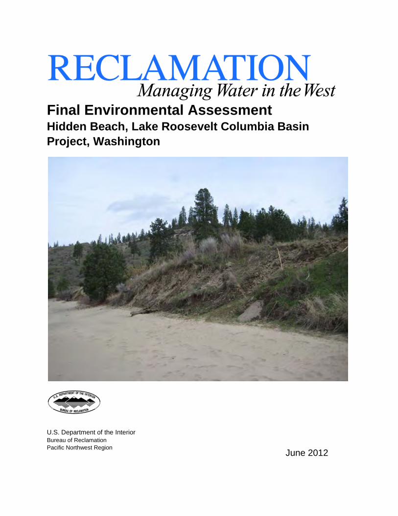
In accordance with the National Environmental Policy Act (NEPA), the U.S. Department of the Interior, Bureau of Reclamation (Reclamation) has prepared an Environmental Assessment (EA) that evaluates the environmental effects of Reclamation's proposed Hidden Beach Bank Stabilization Project.
Hidden Beach is located on the north shore of the Spokane Arm of Lake Roosevelt in northeastern Washington . Lake Roosevelt is formed by the impoundment of the Columbia River by Grand Coulee Dam. The purpose of the project is to arrest shoreline erosion and to prevent associated inadvertent exposure of cultural resources at the Hidden Beach site, while still allowing for continued recreation access and use.
Alternatives Considered
Alternatives that were considered in detail in this EA were based on the stabilization method. The four action alternatives are: Option 1- gabion baskets, Option 2 -riprap with filter bedding, Option 3- fiber encapsulated soil lifts (FESL), and Options 4-integrated methodologies. NEPA regulations require the action agency to consider a No Action alternative for comparative analysis purposes.
Option 1 - gabion baskets
Under this option, a gabion structure would be installed consisting of a series of rectangular wire mesh baskets that are filled with rock and wired together to form a gravity-type retaining wall. Geotextile fabric and biodegradable coconut fiber erosion control fabric would be used in the design to stabilize the soil and reduce erosion until vegetation is adequately re-established.
Option 2 - riprap with filter bedding
Under this option riprap and filter bedding would be used to shield the eroding bank from wave action. Riprap revetments would consist of a layer of well-graded rock that is placed on gravel filter bedding. The filter bedding would act as a transitional layer between the bank material and the riprap to allow for proper drainage while preventing pumping. It also would provide additional protection to prevent further erosion of the bank material beneath the filter. Biodegradable fabric would be used in the design to reduce erosion until vegetation is adequately re-established.
1
Option 3 - fiber encapsulated soil lifts (FESL)
Under this option a block system consisting of a series of densely packed FESL would be used to support vegetative development. Live plant cuttings such as willow stakes would be positioned between the layers of fabric material to protrude from the bank face. As the plants develop the fabric material would degrade. The established root system would help bind the soil particles of the bank material and the developed branches would protect the bank from further erosion. Biodegradable fabric is used in the design to reduce erosion until the vegetation is adequately reestablished.
Option 4 - integrated methodologies (Preferred Action)
This option would combine gabion baskets with FESL. The existing ground at the toe of the slope would be excavated down 2 feet and coarse gravel bedding would be emplaced as a foundation for the gabion structure. FESL would be installed on top of the gabion structure and would be seeded and/or planted with native vegetation. The proposed action would integrate the long-term structural benefits of gabion baskets or riprap with the vegetative and aesthetic benefits of soil lifts.
Consultation and Coordination
The Spokane Tribe of Indians has been consulted on the project and has been involved in review of the design and environmental compliance. During the development of the EA, the Tribe has provided valuable information on project site and cultural resources located in vicinity of the project.
The proposed action will follow the requirements of Section 106 of the National Historic Preservation Act of 1966 (As Amended). Reclamation will be in ongoing consultation with the Spokane Tribe of Indians THPO about any potential for the project to affect historic properties. As construction plans and potential impact change, Determination of Eligibility, Findings of Effect, and mitigation plans are developed to minimize any adverse effect on historic properties and cultural objects. The THPO will also be specifically invited to comment on the draft and final EA prior to the completion of the NEP A process.
Summary of Environmental Effects for the Preferred Alternative Option 4
Soils - There will be minor, short term, localized disturbance and compaction of soils immediately adjacent to the site as the stabilization structure is in tailed. Over the long term, site stabilization will protect soils from further erosion due to wave action, lake fluctuations, and other influences.
Wildlife - There will be minor, short term, localized disturbance of wildlife habitat immediately adjacent to the site as the stabilization structure is installed. Disturbed and stabilized areas would be seeded or planted with native species to help restore habitat values.
2
Recreation Values and Uses - There may be minor, short term noise, visual, and access-related impacts to recreation values and uses as the stabilization structure is installed. Over the long term, site stabilization will help protect recreation improvements, values, and uses at the site. Access between the beach and terrace will be provided through construction of stairs and a pathway.
Cultural Resources - The proposed shoreline stabilization project would provide immediate and long-term protection from erosion for the Hidden Beach site and associated cultural resources. There is low potential for disturbance of cultural resources due to proposed archeological excavation at the toe of the slope to establish a foundation for the gabion structure. Prior to any work being conducted Reclamation will contact the STI THPO to obtain a ground disturbance permit. Reclamation will provide all necessary information to complete the permit process including, but not limited to: project location information, abstract, previous research of the area, methods, a management plan, and an inadvertent discovery plan.
A cultural monitor from the Spokane Tribe of Indians Historic Preservation Department Program will be present on site to monitor any potential disturbance of archaeological sites. Should cultural resources be discovered during construction, the Spokane Tribe of Indians representative is authorized to stop all ground disturbing activities in the area of the archeological resource. Construction will not resume until all mitigation measures developed in consultation with the THPO have been completed. The construction crew will be made aware of the potential presence and recognition of archeological materials and to avoid areas that may contain archaeological materials.
Water Quality - The water quality conditions within Lake Roosevelt are not expected to change due to proposed action. Erosion from the toe of the terrace is expected to be minimized under the proposed action but due to the size and low retention time of Lake Roosevelt, this reduction in suspended sediment would not be noticeable in the offshore areas of the reservoir.
Vegetation- There will be minor, short term, localized disturbance and compaction of vegetation immediately adjacent to the site as the stabilization structure is installed. Disturbed and stabilized areas would be seeded or planted with native species to help stabilize soils and improve the appearance of the completed project.
Threatened and Endangered Species - The project would have no affect on listed Threatened and Endangered species in the project area. Listed species that occur in Ferry County are Grizzly Bear, bull trout, and Canada lynx.
Cumulative and Indirect Impacts- Cumulative effects can result from individually minor, but collectively significant actions taking place over a period of time. Cumulative impacts were considered for each of the options and none were identified for the resources analyzed.
3
Finding
Based on the analysis of the environmental impacts presented in the EA and consultation with potentially affected agencies, tribes, organizations, and the general public, Reclamation concludes that implementation of the preferred alternative, Option 4, will not have a significant effect on the quality of the human environment or natural and cultural resources. The effects of the preferred alternative will be minor and localized. Therefore, preparation of an environmental impact statement (EIS) is not required.
Recommended:
Date
Approved:
Power Manager Date Grand Coulee Power Office, Grand Coulee, Washington
4
Final Environmental Assessment Hidden Beach, Lake Roosevelt Columbia Basin Project, Washington
U.S. Department of the Interior Bureau of Reclamation Pacific Northwest Region
June 2012
U. S. DEPARTMENT OF THE INTERIOR
The Department of the Interior protects and manages the Nation’s natural resources and cultural heritage; provides scientific and other information about those resources; and honors its trust responsibilities or special commitments to American Indians, Alaska Natives, and affiliated
island communities.
BUREAU OF RECLAMATION
The mission of the Bureau of Reclamation is to manage, develop, and protect water and related resources in an environmentally and economically sound manner in the interest of the American
public.
Table of Contents
List of Tables ............................................................................................................................................... iii
1 Introduction ........................................................................................................................................... 1
1.1 Purpose and Need for Action ........................................................................................................ 1
1.2 Proposed Federal Action ............................................................................................................... 1
1.3 Project History and Planning Context ........................................................................................... 4
1.4 Legal and Policy Considerations ................................................................................................... 4
1.5 Scoping ......................................................................................................................................... 6
2 Description of Alternatives ................................................................................................................... 7
2.1 Stabilization Methodologies Considered ...................................................................................... 7
2.1.1 Option 1 - gabion baskets ...................................................................................................... 7
2.1.2 Option 2 - riprap with filter bedding ..................................................................................... 8
2.1.3 Option 3 - fiber encapsulated soil lifts (FESL) ..................................................................... 9
2.1.4 Option 4 - integrated methodologies (Preferred action)........................................................ 9
2.1.5 Features and Practices Common to all Options .................................................................... 9
2.2 The no action alternative ............................................................................................................. 10
2.3 Summary C omparison of Alternatives and Impacts ................................................................... 22
3 Affected Environment and Environmental Consequences.................................................................. 23
3.1 Soils............................................................................................................................................. 23
3.1.1 Existing Environment ......................................................................................................... 23
3.1.2 Environmental Consequences ............................................................................................. 23
3.2 Recreation Values and Uses ........................................................................................................ 23
3.2.1 Existing Environment ......................................................................................................... 23
3.2.2 Environmental Consequences ............................................................................................. 23
3.3 Water Quality .............................................................................................................................. 23
3.3.1 Existing Environment ......................................................................................................... 24
3.3.2 Environmental Consequences ............................................................................................. 24
3.4 Vegetation ................................................................................................................................... 25
3.4.1 Existing Environment ......................................................................................................... 25
3.4.2 Environmental Consequences ............................................................................................. 25
i
3.5 Wildlife ....................................................................................................................................... 25
3.5.1 Existing Environment ......................................................................................................... 25
3.5.2 Environmental Consequences ............................................................................................. 26
3.6 Threatened and Endangered Species ........................................................................................... 26
3.6.1 Existing Environment ......................................................................................................... 26
3.6.2 Environmental Consequences ............................................................................................. 26
3.7 Cultural Resources ...................................................................................................................... 26
3.7.1 Existing Environment ......................................................................................................... 27
3.7.2 Environmental Consequences ............................................................................................. 27
3.8 Cumulative Effects ...................................................................................................................... 28
4 Consultation and Coordination ........................................................................................................... 28
4.1.1 National Historic Preservation Act ..................................................................................... 28
4.2 Tribal Coordination and Consultation ......................................................................................... 28
5 References ........................................................................................................................................... 28
ii
List of Figures
Figure 1-1 Location map ............................................................................................................................. 2 Figure 1-2. Existing site plan ....................................................................................................................... 3 Figure 2-1 Alternative 1 – Gabion baskets plan........................................................................................ 11 Figure 2-2 Option 1 – Gabion Baskets sections ........................................................................................ 12 Figure 2-3 Option 1 – Gabion Baskets detail ............................................................................................ 13 Figure 2-4 Option 2 – Riprap/Filter Bedding plan .................................................................................... 14 Figure 2-5 Option 2 - Riprap/Filter Bedding sections .............................................................................. 15 Figure 2-6 Option 2 – Riprap/Filter Bedding detail .................................................................................. 16 Figure 2-7 Option 3 – FESL plan.............................................................................................................. 17 Figure 2-8 Option 3 – FESL sections ........................................................................................................ 18 Figure 2-9 Option 3 – FESL detail............................................................................................................ 19 Figure 2-10 Option 4 – FESL and Gabion Baskets Detail ........................................................................ 20 Figure 2-11 Stairs – Sections and detail .................................................................................................... 21
List of Tables Table 2-1. Riprap sizes required to fully support the bank. ........................................................................ 8 Table 2-2 Required particle sizes for each layer of gravel filter bedding for adequate drainage and protection from piping. ................................................................................................................................. 8
iii
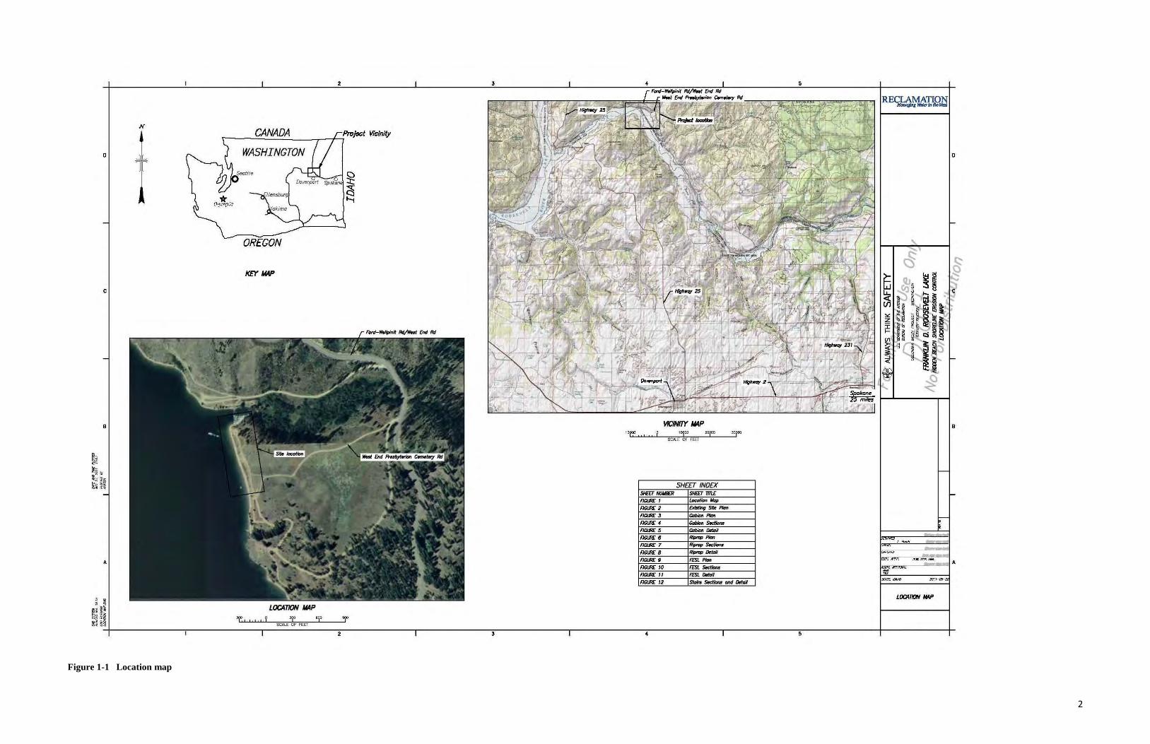
1 Introduction This environmental assessment (EA) identifies environmental effects expected to result from stabilizing approximately 500 feet of shoreline on the north shore of the Spokane Arm of Lake Roosevelt in northeastern Washington (see Figure 1-1 for location map). The Bureau of Reclamation (Reclamation) and Bonneville Power Administration (BPA)are a part of the Federal Columbia River Power System (FCRPS) Project, and are responsible for the operation and maintenance of Grand Coulee Dam, which impounds waters of the Columbia River to form Lake Roosevelt (Franklin Delano Roosevelt Reservoir). Although Reclamation is the lead for this particular stabilization project, the larger FCRPS project has joint federal leads and is jointly funded. Reclamation is the federal agency which would design and provide general construction oversight for the proposed project.
Upon completion of this EA and associated consultation and coordination activities, the Grand Coulee Power Office Manager will determine whether or not an environmental impact statement is required before making a final decision on the project. Reclamation is preparing this EA in coordination with the Spokane Tribe of Indians.
1.1 Purpose and Need for Action Action is needed to arrest shoreline erosion and to prevent associated inadvertent exposure of cultural resources at the Hidden Beach site, while still allowing for continued recreation access and use. Wave action occurring when Lake Roosevelt is at or near the full pool water surface elevation destabilizes the low bluff below the site causing it to erode and slump. In order to stop the erosion, it is necessary to create a barrier at the toe of the slope that will protect the bluff from the energy of the waves.
1.2 Proposed Federal Action The proposed Hidden Beach Bank Stabilization Project is located in the NE ¼ of Section 7, Range 37 E, Township 28 N, W.M. (see Figure 1-2 for existing site plan). The proposed treatment would involve the installation of gabion baskets and fabric encapsulated soil lifts, coupled with reseeding and/or vegetative plantings to arrest bank erosion and stabilize the site. Stairways and a ramp also would be installed to accommodate continued public access between the parking area above the bank and the beach below. Minor changes would be made to the adjoining road, parking areas, and campsites; these include surfacing a portion of road with gravel, capping one existing campsite with rock, and closing a portion of road to reduce impacts from vehicles. Protective fencing and an interpretive plaque also would be installed. The proposed action, construction methods, and mitigation measures take into account the cultural significance of the site and have been developed through consultation with the Department of Natural Resources of the Spokane Tribe of Indians. Reclamation would work with the Tribal Historic Preservation Office (THPO) to obtain a ground disturbance permit prior to initiating work on the project. THPO staff would monitor all phases of pre-construction and construction activity.
1
N CANADA Projsct Vicinity
----~~~~---r~~
D WASHINGTON
KEY MAP
c
B vtCINfTY MAP B 10000
SC.ALE OF FEET
SHEET INDEX SII£U /IIJIJBDI SlifEr 711l£
FICURE: I l..ocotion"""' FICURE: 2 cxioting Site Pl<m FICURE: .J Cobion Ploll
FICURE: 4 Cobion Secti<JM
FICURE: 5 Cobion o.tail
FICURE: 6 Riplclp-
FICURE: 7 Riplclp 5-FICURE: 8 Riplclp O.tg;~
A FICURE: II FF5I. Pion
FICURE: 10 FF5I. s.cticM FICURE: I I FF5I. DoiiJil FICURE: 12 5taito s.ctions Qlld o.ttJi/
LOCATION MAP . ~ ~: ~~ ~~~§ '1',,,,y 'Y' 'Y' ~~ ~§ SCALE OF FEET
·~----------.-----------.-~~~----.----------,----------~3-----------r----------~----------,-----------s-----------1----------r
LOCA110N MAP
Figure 1-1 Location map
2
A
; !
3
1. HOIIIlt!IUAL ctlfT80l; 1HC 2010 !I'M!' 1/ASlD ON R£(XJIII) OXYIOHI~ OF I'OIIIT t~ ON USSR BOLINDAIW.
2. lfHl!:A( CfJ!fllla · 114SW ON fiiW4110HS AT IMiROIICT 57:41n'l AT GIIIN) C0W:C 001.
J. lbjmnlpl qql y.tj;pl Qptym; w..Nnglon Stolo -. Norlh ZOM, Norl1r-- 0oMr 1921, - Dtrfum VS/1111a29, tJSs.-yF ....
0
8
~~ ~~
iHi~~ ---------.,--------,,--------:r--------,r--------:r---------r-------r-~--------r---------~--------T---~--·~-· --T
Figure 1-2. Existing site plan
3
1.3 Project History and Planning Context Archeologists and Native American tribal members have long been aware of the rich cultural history found along the shoreline of Lake Roosevelt. Since 1975, over 600 archaeological/cultural sites have been recorded by the Confederated Tribes of the Colville Reservation (Colville Confederated Tribes or CCT), the Spokane Tribe of Indians, BPA, the National Park Service (NPS) and Reclamation. These sites are representative of the many camps and villages utilized by Native Americans who gathered along the river and nearby terraces to take advantage of the rich fishery of the Columbia River. Evidence of this activity is still found today along the shoreline and terraces surrounding Lake Roosevelt.
Shoreline erosion and landslides associated with the operation of Lake Roosevelt have been evident since the completion of Grand Coulee Dam in 1942. Reclamation monitors shoreline erosion and attempts to reduce landslides by controlling the magnitude and rate of annual reservoir drawdowns. Control of larger landslides through on-site engineering or by other means is generally impractical. However, Reclamation, NPS, and Tribal governments have taken action where practicable to mitigate the effects of shoreline erosion to protect important cultural and natural resources.
In May 2009, Reclamation and Spokane Tribe of Indians Tribal Preservation Department staff conducted a geologic evaluation of shoreline erosion at ten cultural resource sites on the Spokane Arm of Lake Roosevelt in eastern Washington. The purpose of the evaluation was to assess site conditions and processes causing bank instability, and develop initial concepts for potential treatment alternatives and priorities. Following the evaluation the Hidden Beach site was selected for a more detailed, appraisal-level investigation (Reclamation 2011). The nature and extent of the proposed treatment and alternatives addressed in this EA are based largely on the results of that investigation.
1.4 Legal and Policy Considerations Grand Coulee Dam and Roosevelt Lake are key features of the Columbia Basin Project (CBP). The groundwork for the CBP started with the allocation of funds for Grand Coulee Dam pursuant to the National Industrial Recovery Act of 1933; the CBP was specifically authorized for construction by the Rivers and Harbors Act approved August 30, 1935. The Columbia Basin Project Act of March 10, 1943, reauthorized the project, bringing it under the provisions of the Reclamation Project Act of 1939. The CBP is operated and maintained by Reclamation for multiple purposes, including flood control, improved navigation, streamflow regulation, storage and delivery of irrigation water, electrical power generation, and other beneficial uses.
In connection with its responsibilities for constructing, operating, and maintaining the CBP, Reclamation has withdrawn or acquired lands or the right to use lands under the federal reclamation laws. Some of the land acquired, withdrawn or used by Reclamation, including the Hidden Beach site, is located within the boundaries of the Spokane Indian Reservation. The
4
Tribe retains certain governmental authority and responsibilities for lands and resources within the exterior boundaries of its reservation.
In April, 1990, Reclamation, the Spokane Indian Tribe, the Colville Confederated Tribes, the National Park Service, and the Bureau of Indian Affairs signed the Lake Roosevelt Cooperative Management Agreement. This agreement outlines roles and responsibilities of the five parties and defines how recreation resources and uses will be managed at Lake Roosevelt. Under the agreement the Spokane Tribe of Indians is responsible for management of recreation uses and facilities at the Hidden Beach site, consistent with the purposes for which the CBP was established. The agreement recognizes and reinforces the trust duty of the Secretary of the Interior to the two tribes. The agreement also addresses the mitigation of damage to natural resources within the reservations caused by CBP operations and the protection and retention of historical, cultural and archaeological resources.
The National Historic Preservation Act (NHPA) established requirements and programs to enhance the preservation of historic resources. Section 106 of the Act requires that federal agencies, prior to initiating or permitting a project, must “…take into account the effect of the undertaking on any district, site, building, structure, or object that is included in or eligible for inclusion in the National Register.” Section 110 of the Act requires federal agencies to assume responsibility for the preservation of historic properties which they own or control. The NHPA essentially established a legal framework requiring agencies to act as stewards of all cultural resources for which they are responsible.
The Archaeological Resources Protection Act was enacted to “secure, for the present and future benefit of the American people, the protection of archaeological resources and sites which are on public lands and Indian lands…” The Act affords protection for archaeological sites by requiring agencies to establish uniform regulations for the issuance of permits to individuals wanting to excavate or remove archaeological resources from federal lands. Section 6 of the Act states that “No person may excavate, remove, damage, or otherwise alter or deface or attempt to excavate, remove, damage, or otherwise alter or deface any archaeological resource located on public lands or Indian lands unless such activity is pursuant to a permit issued under section 4 of this Act….”.
Section 3 of the Native American Graves Protection and Repatriation Act addresses the custody of cultural items found on federal or tribal lands after November 16, 1990, while section 8 provides for repatriation of items found before that date. Section 3 also identifies procedures regarding the inadvertent discovery of Native American remains, funerary objects and objects of cultural patrimony during federal actions.
The National Environmental Policy Act and associated regulations, as applied to the proposed Hidden Beach stabilization project, require that an environmental assessment be prepared. Based
5
on this assessment, a determination will be made as to whether or not preparation of an environmental impact statement is necessary.
1.5 Scoping Given the high sensitivity regarding cultural resource protection at the site, coupled with the small footprint of the proposed project and experience gained in completing similar projects at Lake Roosevelt, scoping for the Hidden Beach Bank Stabilization Project has been limited to Reclamation staff, managers, and other agencies with a direct interest in protection of this site. The Spokane Tribe of Indians Tribal Preservation Department and Department of Natural Resources staffs have been involved in site assessments and in developing design details for the proposed action. Through a series of meetings and site visits, it was determined that slope stabilization is necessary to prevent further erosion and potential exposure and loss of cultural resources.
Associated issues and impacts to be considered and addressed through project design, assessment, and implementation were also identified. The primary issues of concern are the continued erosion of shoreline at the Hidden Beach site and the associated potential for exposure and loss of cultural resources. Other issues of concern include the possible effects of the proposed action and alternatives on soils, vegetation, wildlife habitat, listed species, water quality, recreation, public access, and site aesthetics.
A number of other potential issues or impact topics were briefly considered and dismissed from further consideration as summarized below.
Air Quality and Climate Change
Air quality and climate change will not be evaluate in this EA because the project is short in duration and its impacts to air quality and climate change are not measureable.
Environmental Justice
Executive Order 12898 requires Federal Actions to Address Environmental Justice in Minority Populations and Low-Income Populations, dated February 11, 1994, requires Federal agencies to identify and address disproportionately high and adverse human health or environmental effects of their actions on minorities and low-income populations and communities, as well as the equity of the distribution of the benefits and risks. Environmental justice will not be analyzed in this EA because none of the project alternatives would have health or environmental effects on minorities or low-income populations or communities.
Social and Economic Conditions
Socioeconomics will not be evaluated in this EA because none of the project alternatives have the potential to significantly affect economic activities.
Indian Trust Assets
6
The Secretary of the Interior has defined Indian Trust Assets(ITAs) as lands, natural resources, money, or other assets held by the Federal government in trust or that are restricted against alienation for Indian tribes and individual Indians (Department of the Interior, Secretarial Order No. 3215). Reclamation usually takes this to mean that ITAs include water rights, lands, minerals, hunting and fishing rights, money, and claims.
The project would not involve actions on trust lands, and it would not reduce the ability of Indians to hunt, fish, and boat in the Spokane reservations or associated trust lands. Therefore, Indian trust resources will not be evaluated in this EA.
2 Description of Alternatives The decision to be made involves two basic alternatives: either implement shoreline stabilization measures to protect the Hidden Beach site (the proposed action) or take no action.
2.1 Stabilization Methodologies Considered The proposed action was developed through consideration and analysis of four bank stabilization methodologies; these include gabion baskets, riprap with filter bedding, fabric encapsulated soil lifts (FESL), and an integrated or hybrid option utilizing either gabion baskets or riprap with FESL.
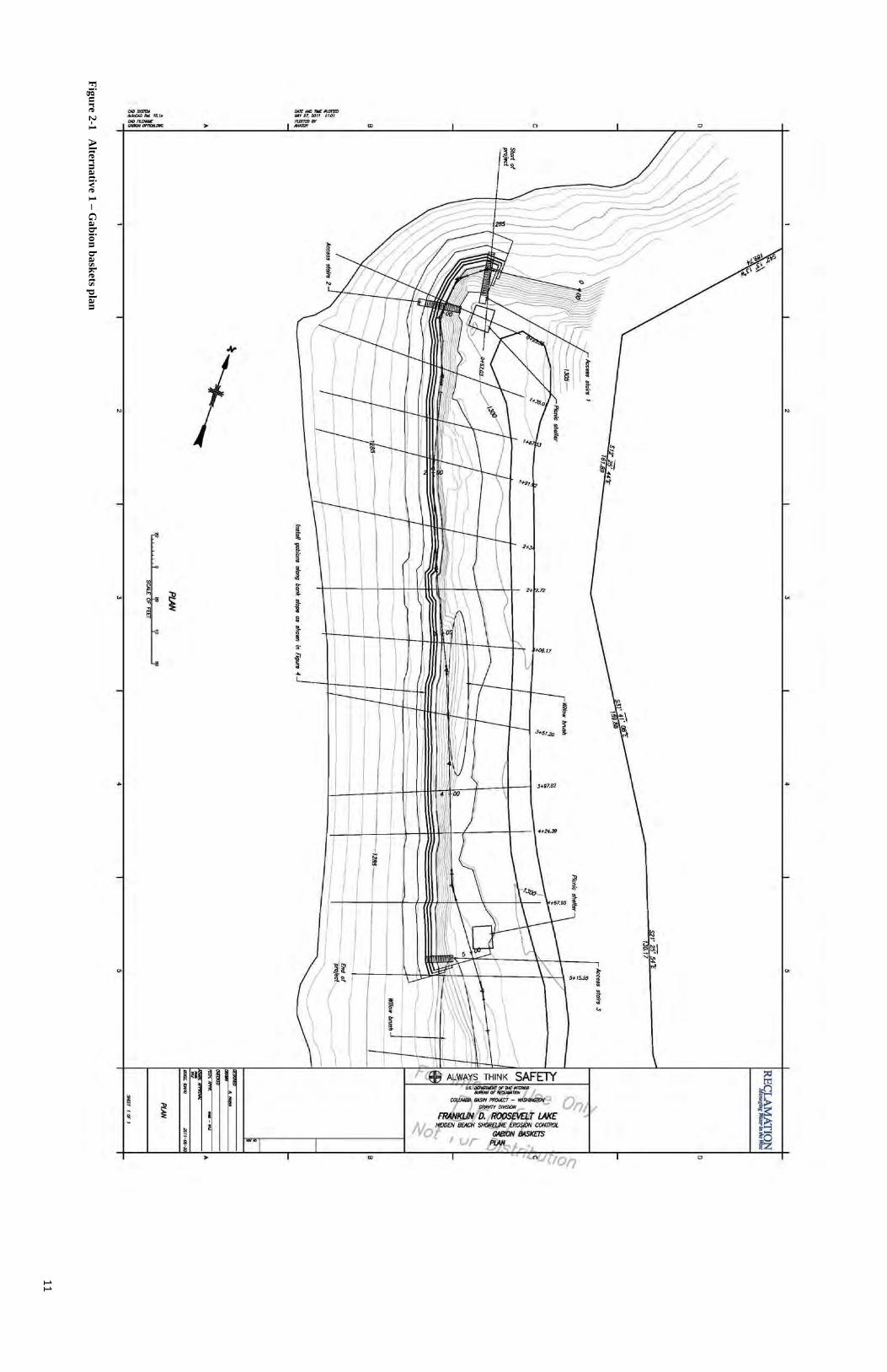
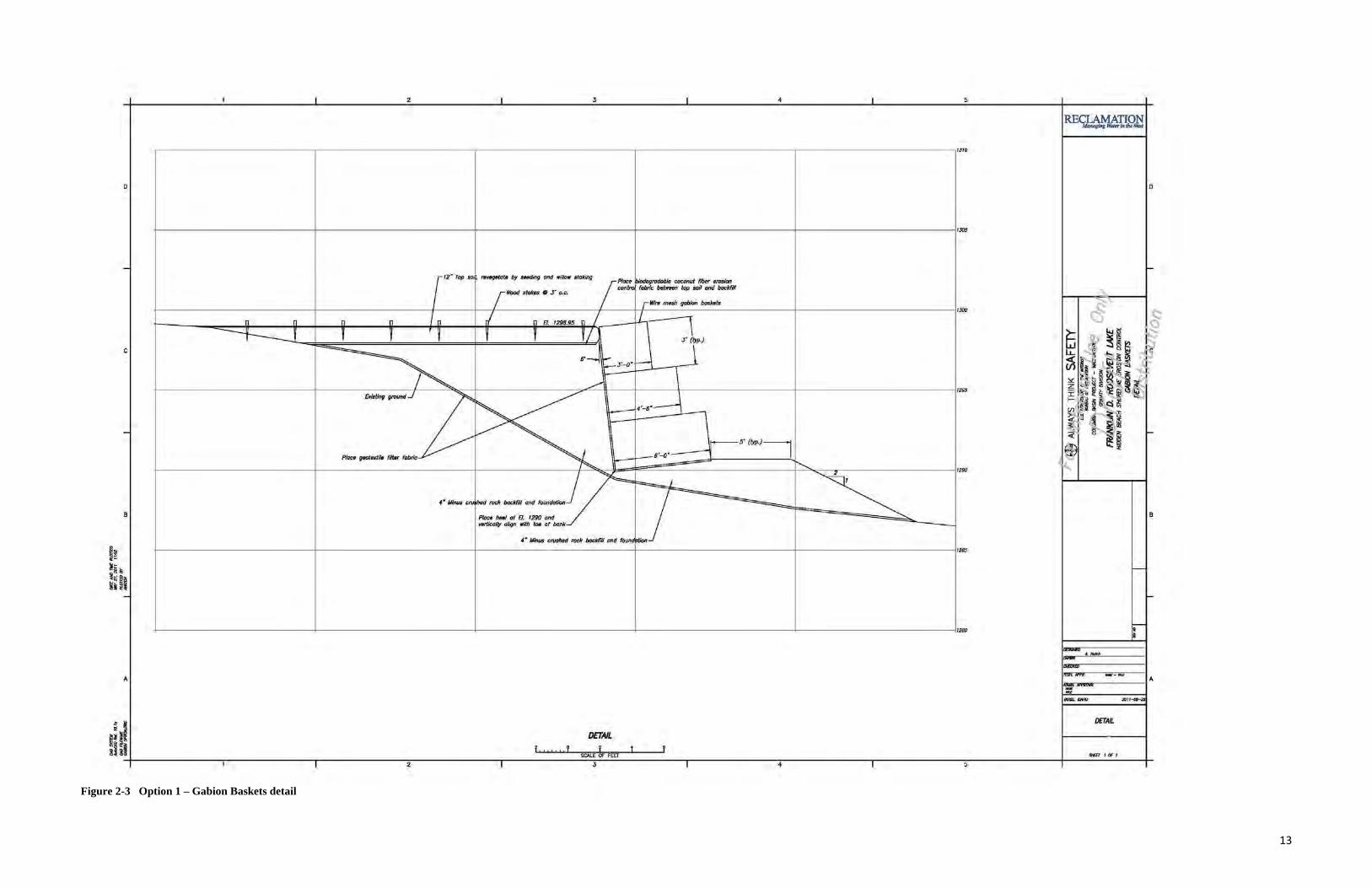
2.1.1 Option 1 - gabion baskets Under this option, a gabion structure would be installed consisting of a series of rectangular wire mesh baskets that are filled with rock and wired together to form a gravity-type retaining wall. Geotextile fabric and biodegradable coconut fiber erosion control fabric would be used in the design to stabilize the soil and reduce erosion until vegetation is adequately re-established.
Three different foundation sub-options were considered. Each would provide proper support for the gabion structure while being flexible to allow the foundation to conform to variations in the bank face. In addition, each would be permeable to allow for proper drainage. One option considered is a Reno mat foundation, which uses a form of gabion baskets that are wider than and not as deep as standard gabions. Another option is to place a layer of coarse gravel fill on the face of the bank and construct the gabion baskets on the gravel. A third option is to excavate a portion of the bank to expose stronger subsurface material and place a layer of coarse gravel fill over the exposed soil. This option would provide a more stable base for the coarse gravel fill; however, it would increase the risk of exposing any buried cultural resources that may be in the area. Each of these foundation options offers similar structural advantages at varying costs.
The advantages of gabion structures include stability and flexibility, allowing them to conform to ground movement and minor settlement. Voids in the rock provide permeability, allowing needed drainage. They are generally low maintenance and can serve as an immediate solution for long-term shoreline and bank protection. Disadvantages include low aesthetic value and minimal value as a vegetative substrate. Some recreational users at the Hidden Beach site may bypass the proposed stairways and walk on the gabions to access the beach from the terrace above.
7
A plan, sections, and detail of the proposed gabion baskets are shown in Figures 2-1, 2-2, and 23.
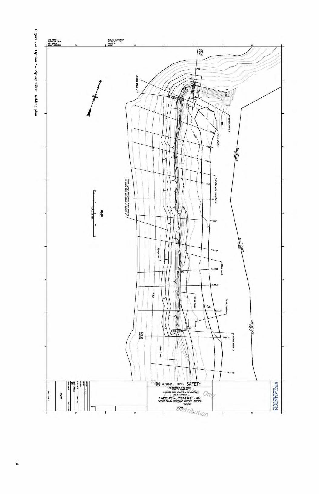
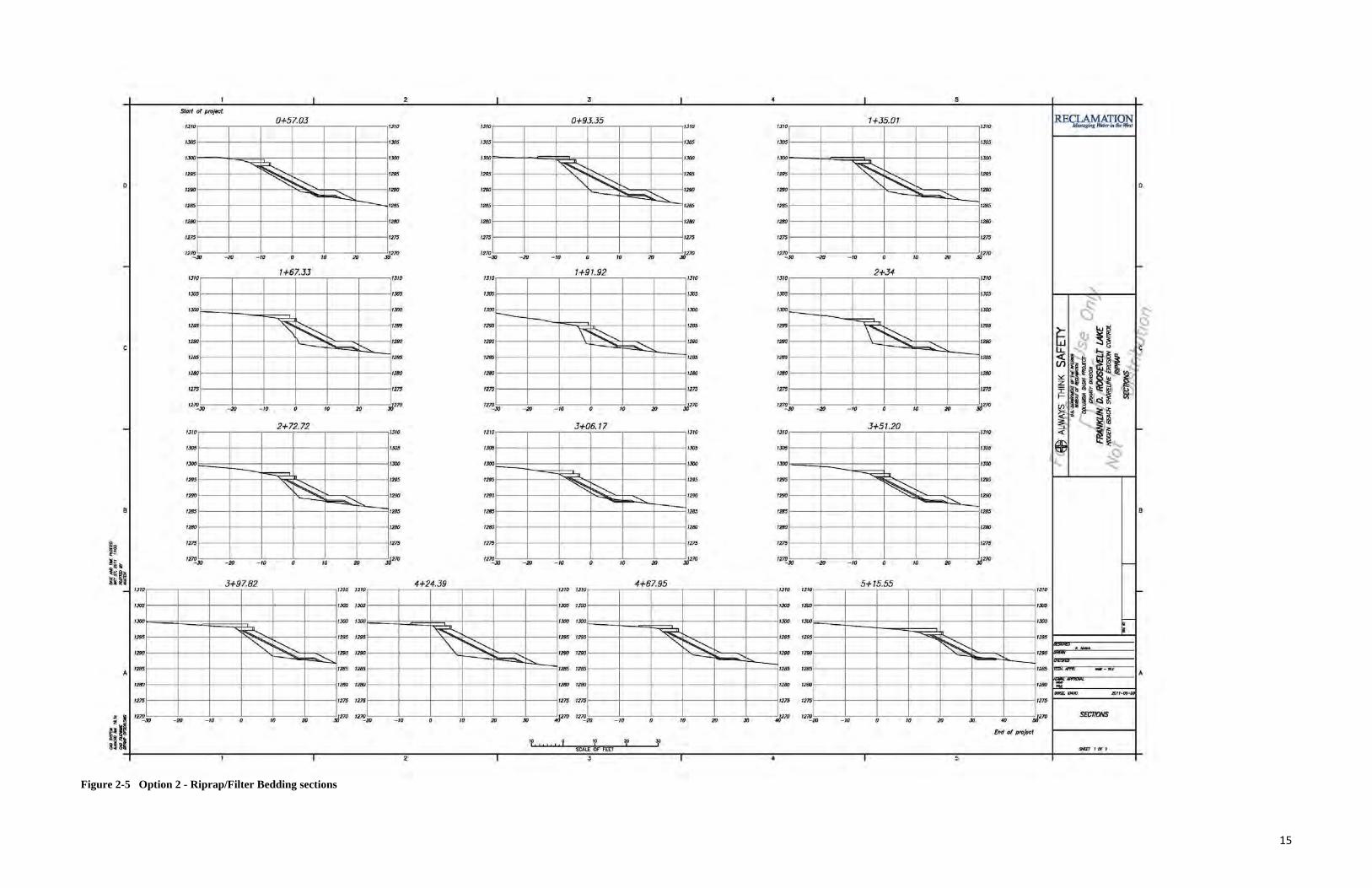
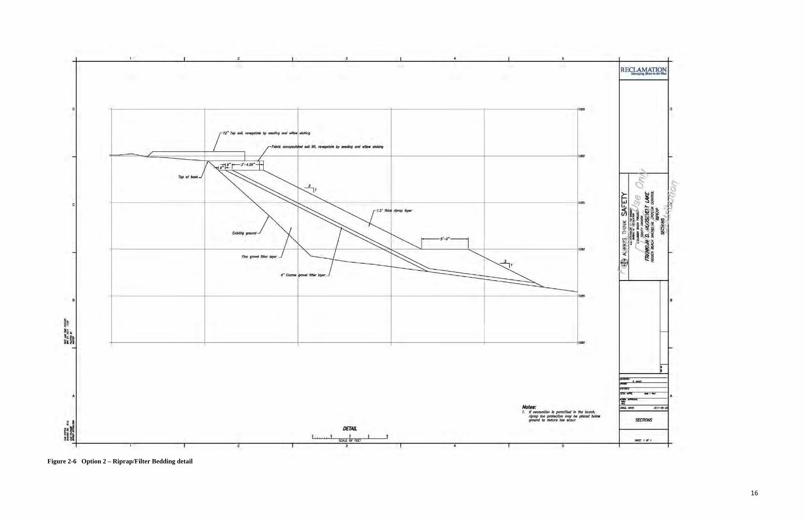
2.1.2 Option 2 - riprap with filter bedding Under this option riprap and filter bedding would be used to shield the eroding bank from wave action. Riprap revetments would consist of a layer of well-graded rock that is placed on gravel filter bedding. The filter bedding would act as a transitional layer between the bank material and the riprap to allow for proper drainage while preventing piping. It also would provide additional protection to prevent further erosion of the bank material beneath the filter. Biodegradable fabric would be used in the design to reduce erosion until vegetation is adequately re-established.
Approximately 500 feet of the eroding bank would be protected with rock riprap. The thickness of the riprap would be 18 inches with two layers of gravel filter bedding, each 4 inches thick.
Table 2-1. Riprap sizes required to fully support the bank.
Percent Particle Size Particle Size (inches) D0 1 D15 2 D50 6 D85 8 D100 12
Table 2-2 Required particle sizes for each layer of gravel filter bedding for adequate drainage and protection from piping.
Percent Passing Sieve Size (inches) Sieve Designation Bottom Layer (Fine Gravel)
D5 0.0029 No. 200 D50 0.0059 No. 100 D100 0.0165 No. 40
Top Layer (Coarse Gravel) D0 0.0331 No. 20 D50 0.1870 No. 4 D100 1.0000 1 in.
One advantage of riprap and filter bedding is that it can be used to create a flexible revetment conforming to the contours of the existing bank. Like gabion structures, riprap and filter bedding is highly permeable, allowing for good drainage, and can serve as an immediate solution for long-term shoreline and bank protection. It can be easily repaired by replacing or adding rocks to areas where riprap appears weak. Properly installed riprap can provide a more natural appearance than gabion structures and also can allow for some vegetative development. Disadvantages include the susceptibility of riprap to displacement and deterioration; thus it must be inspected on a regular basis and can be expected to require more maintenance than gabion
8
structures. Riprap and filter bedding must be properly placed to insure that the revetment functions properly. Recreation users at the Hidden Beach site may bypass the proposed stairways and use the riprap to access the beach from the terrace above.
A plan, sections, and detail of the riprap and filter bedding are shown in Figures 2-4, 2-5, and 26.
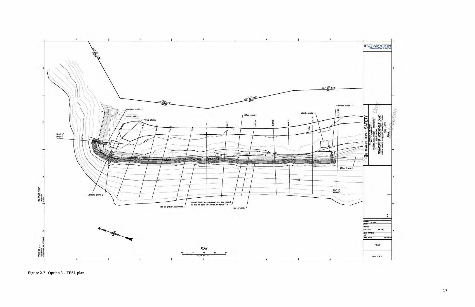
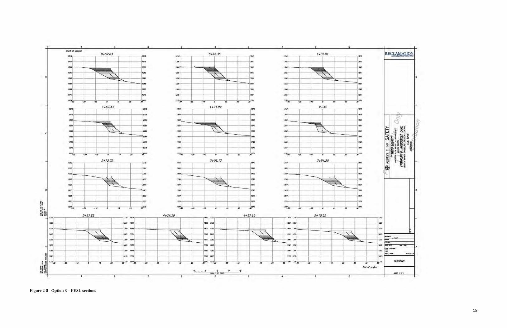
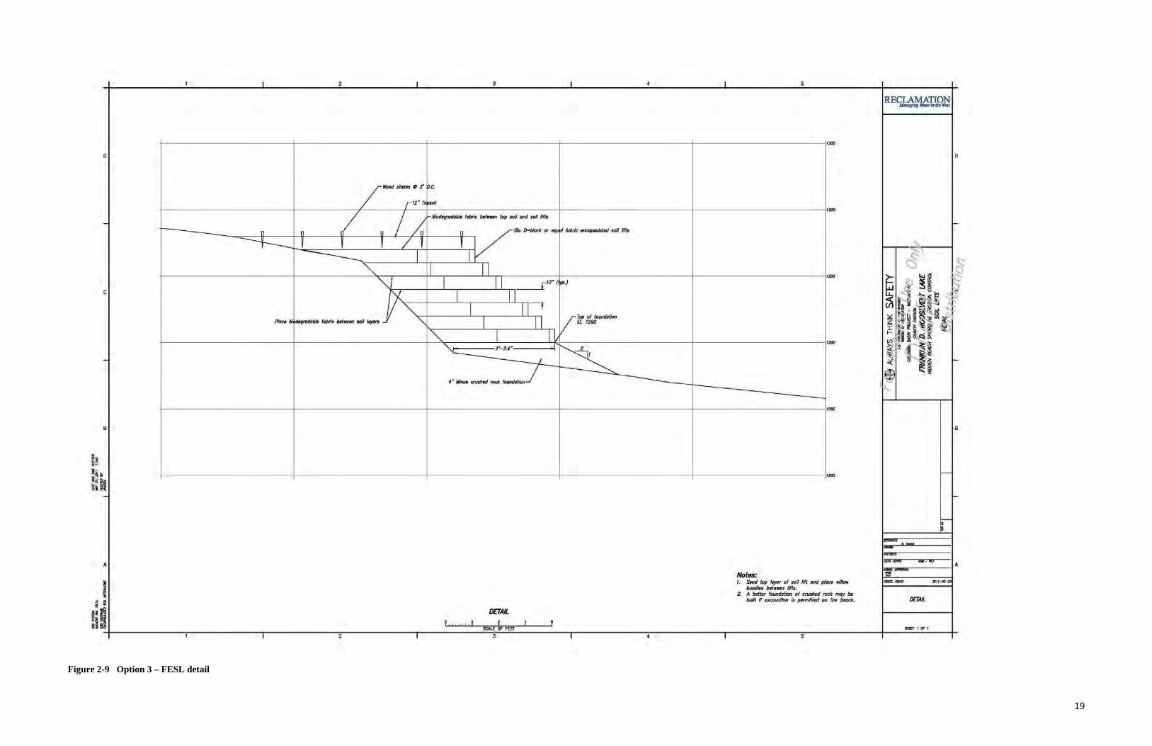
2.1.3 Option 3 - fiber encapsulated soil lifts (FESL) Under this option a block system consisting of a series of densely packed FESL would be used to support vegetative development. Live plant cuttings such as willow stakes would be positioned between the layers of fabric material to protrude from the bank face. As the plants develop the fabric material would degrade. The established root system would help bind the soil particles of the bank material and the developed branches would protect the bank from further erosion. Biodegradable fabric is used in the design to reduce erosion until the vegetation is adequately reestablished. One advantage of FESL is its more natural appearance, which allows it to blend in better with existing features at the site. Properly installed soil lifts can provide immediate support for an eroding bank. However, FESL depends somewhat on vegetation re-establishment to help provide long-term structural support and to improve site aesthetics; thus the long-term integrity and functionality of FESL structures may not be fully secured until vegetation is successfully reestablished. Depending on site characteristics and weather conditions, FESL may require watering, re-seeding, and replacement of unhealthy vegetation. Frequent monitoring generally is required to assure proper vegetative development. Installation of FESL structures may be more difficult than placing riprap or constructing gabions. FESL structures may not hold up well if recreation users elect to use the soil lifts rather than the proposed stairways for access to the beach from the terrace above.
A plan, sections, and detail of the FESL are shown in Figures 2-7, 2-8, and 2-9.
2.1.4 Option 4 - integrated methodologies (Preferred action) This option would combine gabion baskets with FESL. The existing ground at the toe of the slope would be excavated down 2 feet and coarse gravel bedding would be emplaced as a foundation for the gabion structure. FESL would be installed on top of the gabion structure and would be seeded and/or planted with native vegetation. The proposed action would integrate the long-term structural benefits of gabion baskets or riprap with the vegetative and aesthetic benefits of soil lifts.
The option of combining riprap with FESL was also considered (see Figures 2-4, 2-5, and 2-6). The detail of the integrated methodologies is shown in Figures 2-10.
2.1.5 Features and Practices Common to all Options Rocks and gravel needed to implement all options would be taken from a tribally-permitted borrow area located approximately 2.5 miles from the Hidden Beach site.
All options would incorporate access stairs from the top of the terrace (above the proposed stabilization structures) to the beach. Such stairs would serve two purposes: they would facilitate
9
continued recreation access to and from the beach, and would route foot traffic away from the structures and associated re-vegetated areas and thus would help minimize damage to the project and reduce maintenance needs. The stairs would be constructed of composite wood with imbedded texture to limit slippage. The composite wood has an extended life span, which would reduce or eliminate the need for maintenance. The stairs would be place at the full pool level of 1290 feet above sea level and would not protrude into the lake. Sections and details are shown in Figure 2-11. In addition, all options would include an improved, handicap-accessible trail from the parking area to the east end of the beach. Minor changes to the parking area and recreation site above the stabilization structure would also be made to help protect the project and cultural resources at the site.
All options would be implemented consistent with best management practices and standard operating procedures than have been developed by Reclamation to help minimize environmental impacts associated with such construction projects. Work performed under contract would be subject to Reclamation guide specifications addressing water pollution control, protected species, and preservation of historical and archeological data (among other requirements). Work would be performed during periods when reservoir water levels are low enough to permit access to the work area. In addition, work would be scheduled to minimize overlap with the summer period of high recreation use at the site. An optimal work window generally would occur between March 1 and July 1. All work would be monitored by Reclamation and Spokane Tribe of Indians staff.
2.2 The no action alternative Under the no action alternative, no attempt would be made to stabilize the eroding shoreline at Hidden Beach and no extraordinary measures would be taken to protect cultural resources at the site from potential exposure and loss. Periodic monitoring at the site would be carried out by Spokane Tribe of Indians staff. As cultural resources are exposed through erosion and soil movement they would be salvaged in accordance with standard practices.
10
)>
~
OW' Nt() ,.. I'UmfD ,_y 17, 3QH H.!O' Pll1r1ri>IIY -
(
l l I f li
~ ~
f
"' ("")
l[ !\,
~\, \'\8
1:!
~~ ~~~ "'
0 I [2; I
Figure 2-1 A
lternative 1 – Gabion baskets plan
11

1 I 2 I 3 I 4 I 5
start of pro~
~~£>~ 0+57.03 0+93.35 1+35.01 IJIO IJIO IJ IO IJIO IJIO IJIO
IJIJS IJIJS IJIJS IJIJS IJOS IJIJS
IJOO IJOO IJOO fJ(J(} tJtJO IJOO
tm -w-,
t29S 1295 ~ w, t295 tm " ·~
1295
D ~ r--J. ""'
.b ""' lb D t290 -~ t290 t290 - ~
t290 ·- - ....... t290 ,.,__ - - t285 1285 t285 1285 1285 1285
1280 1280 t280 12JJO t281J 12JJO
1175 r;Js ·~75 t~75 t~75 1275
12~ -20 -to 0 tO 20 :JJ2111 12711~ -20 -to 0 to 20 :JJ270 12~ -20 -to 0 to 20 :JJ270
- -1+67.33 1+91.92 2+34 1310 tJIO 1.110 1310 IJfO IJIO
IJIJS ,,., IJOO IJOO ,,., t JIJS ~
tJOO tJOO tJOO tJOO tJOO tJOO ~' "'\. 1--lt r--- \--~ ----..1-l C5
t29$ 129$ ln!l t29$ 129$ 1295
'\ ,b \r -j_ \\-= tl ~ f ~ ~~ ~ t290 - """-129() tno ....... t290 t2JJO t290
c LL ~ ~~~ ; t285 t28S t28S t285 t285 1285 t:i :! t280 t21J() 12110 t280 t21JO 1280 :.::: ~~~~~~ t275 t275 t275 t275 t275 t275
~ I ~~~ ~ !=S 1- .
t2~JD -20 -to 0 tO 20 :JJ270 t21£.ro -20 -to 0 tO 20 :JJ270 tml~ -20 -10 0 tO 20 :JJ270 (!)(
~ ·ql - 2+72.72 3+06.17 3+51.20 ~ -t JtO tJtO t.JIO t3t0 tJtO t3t0 < ~~ t305 1305 t305 t305 t305 t JIJS ~ tJOO tJOO tJOO tJOO tJ()(J tJDO ~ ~ ~
r-----.. -w, - i-l, -..... \- _,_, t295
"' l-:J 12J5 t29.S
~ _b 1295 t295
~ ,-j_ t295
t290 -- .......... 1290 t290 - ....... t29Q t290 - ..........
t290
- - t285 B 1285 1285 t285 t285 t285 B
t280 t280 t2110 t280 t21JO 1280
t275 t275 t275 t275 t275 t275
t270 -JO -20 -to 0 tO 20 :JJ270 12J!l
-JO -20 -tO 0 10 20 :JJ270 lml -JO -20 -10 0 10 20 :JJ270 -
I 3+97.82 4+24.39 4+67.95 5+15.55 - IJfO IJIO IJIO IJ/0 1310 t:JttJ IJIO t.JIO -IJ05 IJ05 IJ05 tJIM IJ05 I JIM tJIM IJ05
IJ()(J IJ()(J IJ(J() tJDO IJOO fJ()() IJ()() fJ()() ::--
1295 f-L,
1290 INS "\:'\-- ... t290 t295 "' -w-,
129/J t295 --......... -w-,
tm
"" 0 "'r -:J_ "" j--:j "'-t-::rl - .... 129() t290 t290 t290 1290 1290 t290 12g(J !-r-- .......... ...... ...... .......... - 1"- - Olt'IID
A 1285 1285 1285 t285 12115 1185 1285 1285 I!MiWII'. --- A
121JO 12tl0 t2tl0 t2tl0 1280 1280 t280 1280 r-= ..,.,._ ""' -- 8111-01-...
1275 1275 1275 t275 t275 1275 1275 1275
I tml~ :JJ270 tml~ :JJ270 121£JO 1270 12~20 5J270 S£CT10NS -JJJJ -10 0 to fJJJ -JJJJ -10 0 to fJJJ -20 -to 0 10 20 JO -to 0 tO 20 JO «<
fJtd of pro;.t:~
I 1f I I I i 'f SCALE OF" Fro"
f "' I
SIO:r r OF r
1 I 2 I 3 I 4 I 5
Figure 2-2 Option 1 – Gabion Baskets sections
12
2 4 5
RECLAMATION ~-mriw:ilt.t
I JIO
D D
I
r ... ro-tofo by 8Mding ond wiflo<lr •taking ( ;"'" " • COCCtNd - ·-r Wood •tolcn • .J" o.c. C<J(Itf.
fabric bet- tap $01/ ond bockfi1l
lllfro moBh gob/on r-Jcol6
/ n j n EJ. 1298.95 n / ~~ I
'-- n n n n
---t---_j l f ~ l l u ~~ ~~r 6"-
1=-.J"-o" w _....
~-J.£ I
1-- 4'-6"---\ ,_
---t---5' (fn>.)i Ptoco gootutn. f;Jtor fabric -6'-()"-
li ~
~--·-::;~7:_1_/ ~ I
I
4" 11/rnJ$ m
..rocoJ/y oJign with too of bonk ..____
c
a a
4" lliiN4 CNIMd rock bt1ckfi1l ond fou11< lion I
12
A
1: ~~ DETAR.
O£TAIL
~hi t I I y t SCAlE OF FE£T SHEET I OF I
2 3 4 5
Figure 2-3 Option 1 – Gabion Baskets detail
13
l1lt1r NID IQw£ /ltOT1llJ IM'I' 0, JOJI H.tJJ 1<11ml)l/lf _.,.
CD 0
~ "'
~ ..1
i(l
§~.1 ... 1; irof
0 I ~;z; I
Figure 2-4 O
ption 2 – Riprap/Filter B
edding plan
14
1 I 2 I 3 I 4 I 5
start of proj«:t
~~,Vl;! 0+57.03 0+93.35 1+35.01 IJIO 1.}10 I J IO IJIO IJIO IJIO
1305 1305 1305 1305 1305 1305
I.Jilll I.Jilll I.JilO I.JilO I.JilO I.Jilll
~ ~ ~r-... ~ 1295 1295 1295 1295 1295 1295
0 1290
~ ~ 1290 1290
""" ~
1290 1290 ""' ~ 1290 0
-......... .................... ~ 1285 i---. 1285 1285 1285 1285 - 1285
12/J(} 12/J(} 12/JO 12/JO 12/JO 12JJIJ
1275 127S 127S 1275 1275 127S
1270 -J1) - 20 - 10 0 10 20
1270 JO
1270 - JO - 20 - 10 0 10 20
1270 JO
1270 -JO - 20 -10 0 10 20
1270 JO
- -IJIO
1+67.33 IJIO IJIO
1+91.92 IJIO IJIO
2+34 IJIO
IJOS IJOS IJ05 IJOS IJOS IJOS ~
I.Jilll I.Jilll IJOO IJOO IJOO IJOO ~l
r--- ~ ~ -121J5
'\ ~ 1295 121J5
\"" ~ 121J5 1295
\' ~ 121/S
~ ~ ~ ~ ~ 12110 12110 12110 12110 t290 1290 c :::....... :::....... lL
~ ~u ~ ,J 1285 t285 1285 1285 tztl$ 12M iJi &'- \ . •. " 12IJO 12IJO t2IJO 12IJO 12/J() 12/J() fH!tt~ ' ~
z 1271$ t271S t27S 127S 127$ 127$ I'
t- . ~~~~~ 12~ -20 -10 0 10 20 J6270 12~ -20 -10 0 tO 20 J6270 12~ -20 -10 0 tO 20 J6270
~ l~l - 2+72.72 3+06.17 3+51.20 -IJIO I.JIO IJIO IJIO 1.}10 IJIO <(
1305 1305 IJ05 1305 t305 IJOS g:, t .. ~ ~ ~ tJOO tJOO tJOO tJOO tJOO IJOO ~
1295 1295 1295 ~ t295 t295 -.;;;;;; :::ll. 1295
~ ~ ~ ~ ~ t--... 1290 :- 1290 t290 t290 t290 12:90
a - - a t285 1285 1285 t285 tztl$ lztl$
12/J(} 12IJO t2IJO t2IJO t2IJO 1180
t27S 127S 127S t27S t27S 1275
12~ -20 10 0 10 20 J&27!) 12~ -20 -10 0 10 20 JJ270 12~ -20 -10 0 10 20 JJ270 -
I 3+97.82 4+24.39 4+67.95 5+15.55 - IJIO IJIO IJIO IJIO t.JIO I.JIO I.JIO I.JIO -t.m IJI» IJOS tJOIJ t.m t.m t.JO:> IJOO
I.Jilll I.Jilll tJOO IJOO IJOO tJOO 1:]()() 1:]()() -~ ~ ~ t295 1295 1295 t295 tns t29$ tns ISS
~ ~ '\. ~ ""' ~ ~ -1290 12JJO 1210 1210 1210 t290 t290 1290 ~ :::....... :--- ....... A
1285 1285 1285 1285 t285 - t285 1285 1285 m~;v,w; --- A
12/J() 121JO t21JO 121JO t2IJO t2IJO t2IJO 12IJO r.:::r-~ ... """""""' JIOH-<&-JIO
t275 127S t275 1275 t27S 1275 127S 127S
k IZ~ JJ270 1270 <J270 127£20 4J270 t270 6J270 S£CTTONS -20 -to 0 tO 20 -20 -to 0 10 1/t) JO -10 0 tO 1/t) JO -I/() -to 0 tO 1/t) JO «J
~ End of pro~
I 'f I I I i 'f SCALE OF FrrT
f 30 I
1ID:1 ' or , 1 I 2 I 3 I 4 I 5
Figure 2-5 Option 2 - Riprap/Filter Bedding sections
15
D
c
B
b J~-
~at
A
2 3 4 5
+-------------------------r-----------------------~-------------------------+-------------------------r------------------------~1~
2
OCT' AIL
i
3 4
tt80
Notes: I. N ~xcavation i8 ,_,;t;ed in the beach,
tiprap toe ptOtection moy btJ placed btJioJI grrxmd to reduce toe /JCOIJT.
5
D
B
!i1D:T I OF r
Figure 2-6 Option 2 – Riprap/Filter Bedding detail
16
Start of projoct
2 3
:1()// lifts (FESt.) tnrton fabric enco~ In Figure 10 to top of bonk ~n
4 5
Figure 2-7 Option 3 – FESL plan
17
1 I 2 I 3 I 4 I 5
storl ol project
REC~,9.l;J 0+57.03 0+93.35 1+35.01 IJIO IJIO IJIO IJIO IJIO IJIO
IJQS I .lOS IJOS 1.105 1305 1305
IJ()/) IJ()/) IJ()/) 13f)/) IJ()/) IJ()/)
11$5 129$ 129$ '<;::::::::~:; P. 129$ 1295 129$
0 12911 12911 12911
~ ~ IWJ 12911 IWJ 0 ---~ - r---r----12/JS 1285 1285 1285 1285
~
1285
1211/J 128/J 128/J 128/J 128/J 128/J
1275 1275 1275 1275 1275 1275
12~ -20 -1/J /} 10 20 -;.)270 12~_, -20 -to 0 10 20 :],5270 12~ -20 -10 0 10 20 -;.)270
- -1+67.33 1+91.92 2+34 IJIO 1310 1310 I.JIO IJIO tJIO
1305 IJO!S 1305 1305 IJO!S IJO!S ' IJ()/) IJ()/) IJVO IJ()() IJO/J IJO/J
~~ - C:5 ~ P. 121JIJ
~ ~ 1295 1295
~ ~ 129$ 129/J
~ 1295
iS , !I · ~ 12SO 1290 1290 1290 1290 1290 1' '"~ ~ c LL 1285 1211!1 1:16$ 1211!1 1211!1 128$ t:i
lh~~ r: 1280 1280 1280 1280 12fJ/J 12fJ/J ::.:: z r~~ . ~s 1275 1275 1275 1275 1275 1275 ~
12~ -20 -10 /} 10 2/J -;.)210 12~ -2/J -1/J /} 10 2/J :],5270 1270-.JO -2/J -10 0 10 2/J -;.!"" (I)( u~
~ 'q; - 2+72.72 3+06.17 3+51.20 ~ -1310 tJtO IJIO t.JUJ tJfO tJtO <(
IJ05 IJ05 IJ05 IJ05 IJ05 IJ05 Lt IJ()() IJ()() IJVO IJ()() IJOIJ IJ()()
1295 '<;; :n. 1211$ 120!5 1205 1295 1295
12911 12911 12911 1290 12911 1290
~ --.;:
B -1285 - B 1285 1285 1285 1285 1285
1240 1280 1280 1240 12fJIJ IZIJO
1275 1275 1215 1275 1275 1275
12~ -2/J -10 /} 1/J 2/J -;J270 12~ -2/J -to 0 10 2/J -;.!"" 1270-.ll) -2/J -10 0 10 2/J -;.)270 -
I .J+97.82 4+24 . .J9 4+67.95 5+15.55 - IJIO tJ IO 1J 10 IJIO IJIO t.JIO IJIO 1.'110 -IJ05 IJ05 IJ05 IJIXJ I .lOS I .lOS I .lOS I .lOS
IJOO 1300 1300 IJOO IJOO IJOO IJOO IJOO ::----
1295 1295 1200 ~. 1290 1293 12110 12 .. 129.>
~ ~ r-- -1290 1290 1290 1290 1290 12110 1290 12911 r-- - r- - -A 12/J!J 12M 12M 12M 1285 1285 1285 1285 ltbZW --- A
121KJ 12110 1200 12t10 1280 1280 1280 1280 r=--
I -- l!OH-C$-M
1275 1275 1275 12, 1275 1215 1275 1275
SECTIONS II 12~ -20 -10 0 10 20 -;.)270 12~ -20 -10 0 10 2/J :],5270 12~ -20 -10 0 10 20 JO 1270 12~20 -10 0 10 20 3/) 40 6J270
I End"' proj«<
•e . I I i '£ f f SCAlE OF FE£T 1H1rr I OF I
1 I 2 I 3 I 4 I 5
Figure 2-8 Option 3 – FESL sections
18
2
D
/Wood slakf$ o Jl
r'z•r.
I lin -" " " ----v--_ ~ ~ ~ /~
---------- I ""-
""-'
(/'""' fobric - I'Oil ,.,.,. J """ Ploc$ .
c
8
A
I ~ ~
3
o.c.
03Ct1
fJiodovr<xlablo fabric wt_, tDp I10il an<1 I'Oil Gf!6
" 8io D-block .,. ..,.
~ I I
I I I I II ____[12" ~
I I I I II'
I II ""- I I ~
~ -/..... ~- NiniR cruslr«< rock foundation
4
~ fabric oncapNated I'Oil h'fts
~)
fl. 1290 / rop of foundaUon
~I ~
5
I
I
I
I
-I
I
Nota: I. S4«J top ~r of 110~ fift ond place willofl
bundln wt-n lifbr. 2. A wtter foundation of crushed rock may be
buill If ucovatlon Is permltttJd on tire beoch.
D
8
1rm-os-n
DETAIL
~:II OCTAIL .. ~" i I I I y I o~o~----------~------------r-----------~----------~----------~~~~~F~m~------~------------~----------~----------~------------4---~xrr~·~~·----~ 2 3 4 5
Figure 2-9 Option 3 – FESL detail
19
0
c
B
I I !
- ZfJ
2
- 70
3
0+57.03
- otokos fl o.o.
3 0 I, I , I, I
SCALE Of FEET
4 5
0
12" top 60il
B
70
o:llu ____________________ ,_--------:~--------~--------~~--------.---------~---------r---------s----------t-~~~~100~,;~~9-12--r ~~ ~~ 3 4 5 2
DETAIL
Figure 2-10 Option 4 – FESL and Gabion Baskets Detail
20
2 3 4 5
1J15 IJ15 RE<t,.LAMATION mu.gt.g - .. t/oilibt
1J10 IJtO
D 1J05 1J05 D
1JOO 1JOO ---
~ 1295 12'15 g- :L.
1290 1200
1285 12B5
c 1281) 1200
1275 12'1$ l!l .. ~ ~
()+(}() O+.l2.98 t I I y t Station S~ OF FEET
stairs 1 STA. 0+00 TO 0+32.98
1J10 IJIO 1J10 IJIO
1J05 1.JO/S 1J05 131>}
B B
1JOO 1.JOO 1JOO 1:JOO
~~ 1295 1205 1295 1200
~~a. [il [il
~li~ll l- l- ~ h ~ 1290 11/10 1290 11/10
1285 1285 1285 1285
1281) 12/JO 1281) 1280
A No~: 1275 1275 1275 1275 1. 4 " CnWrod g~ to ""f'P'rl
:a ~ Q
~ bank I>IM«>Ih IJ1oirs.
~ !!! ~
~ I ()+(}() 0+29.1.J ()+(}() 0+2.J.46 station Station SECTIONS AND OE:rA/1..
~:II stairs 2 stairs 3 l I I ~ l 'f ·~ 8~8~ STA. 0+00 TO 0+29. 13 STA. 0+00 TO 0+23.46 SCALE OF FEET
2 3 4 5
Figure 2-11 Stairs – Sections and detail
21
2.3 Summary Comparison of Alternatives and Impacts Affected
Environment Alternatives Alternative 1: No Action
Cultural Excavation for project foundation may Over the long term, impacts to cultural Resources expose or disturb cultural resources. Site
stabilization will protect cultural resources from further exposure and damage over the long term.
resources would be substantial as the site would continue to erode and resources would be exposed to damage or removal.
Soils There will be minor, short term, localized disturbance and compaction of soils immediately adjacent to the site as the stabilization structure is installed. Over the long term, site stabilization will protect soils from further erosion due to wave action, lake fluctuations, and other influences.
Over the long term, soil and parent material will continue to be undercut by wave action, leading to erosion, slumping, and movement down slope into Lake Roosevelt. The affected area is relatively small; thus the soil loss impacts would also be relatively small.
Vegetation There will be minor, short term, localized disturbance and compaction of vegetation immediately adjacent to the site as the stabilization structure is installed. Disturbed and stabilized areas would be seeded or planted with native species to help stabilize soils and improve the appearance of the completed project.
Over the long term, as soil is lost from the site, the ability of the site to support vegetation will diminish. Given the small size of the affected area, the impacts to vegetation would be relatively small.
Fish and There will be minor, short term, localized Over the long term, as soil and vegetation Wildlife disturbance of wildlife habitat are lost from the site, the ability of the Habitat immediately adjacent to the site as the
stabilization structure is installed. Disturbed and stabilized areas would be seeded or planted with native species to help restore habitat values.
site to provide wildlife habitat will diminish. Given the small size of the affected area, the impacts to wildlife habitat and species would be relatively small.
Listed and Sensitive Species
No listed or sensitive species are known to occur at the site.
Recreation There may be minor, short term noise, Over the long term, site erosion and Values and visual, and access-related impacts to slumping could eventually undercut Uses recreation values and uses as the
stabilization structure is installed. Over the long term, site stabilization will help protect recreation improvements, values, and uses at the site. Access between the beach and terrace will be provided through construction of stairs and a pathway.
existing picnic shelters, parking areas, and associated recreation facilities.
22
3 Affected Environment and Environmental Consequences
3.1 Soils
3.1.1 Existing Environment The terrace at Hidden Beach is 10 feet above the high pool elevation of Lake Roosevelt at elevation 1290.0 feet. The material at the toe of the terrace is composed of alluvial material consisting of sand and gravel with cobbles. At the top of the terrace, the material consists of fine-grained sand and non-plastic silt with fine gravel and cobbles. The bank material has little shear strength and is easily erodible. Wave action, most likely from wind and recreational boating, has caused significant erosion at the contact between the two terrace materials.
3.1.2 Environmental Consequences
3.1.2.1 Proposed Action The bank stabilization project would result in minor short term disturbances to soils adjacent to the site as the stabilization structure is installed. The project would lead to long term stabilization of the soils and shoreline bank protection. Material for the Gabion baskets may be obtained from existing borrow pits located within the Spokane Indian Reservation, but will require coordination with the Bureau of Indian Affairs and approval through the Spokane Tribe’s Interdevelopment Team process.
3.1.2.2 No Action Under the No Action Alternative, the soils that make the shoreline would continue to be eroded by wave action. This would lead to the bank slumping and moving into Lake Roosevelt. Since the affected area is small, the impacts from the soil loss would also be relatively small.
3.2 Recreation Values and Uses
3.2.1 Existing Environment The Hidden Beach site is a developed recreation area which typically is used for picnicking, sunbathing, and swimming. It is popular with local residents; the highest use occurs during midsummer. The site includes four picnic shelters, fire rings, and an access road.
3.2.2 Environmental Consequences
3.2.2.1 Proposed Action The stabilization project would protect the existing recreation structures. Access to the beach would be provided by a newly constructed stairs and pathway.
3.2.2.2 No Action Over the long term, the continued erosion at the site would eventually undercut the existing parking area, picnic shelter, and associated recreation facilities.
3.3 Water Quality
23
3.3.1 Existing Environment Water quality of Lake Roosevelt is regulated by the State of Washington Department of Ecology (Ecology) under the framework of the Clean Water Act. Washington has established water quality standards for specific physical and chemical parameters in order to provide suitable conditions to support designated and potential uses. Some of these uses include agriculture water supply, domestic water supply, stock water supply, industrial water supply, commercial navigation, boating, wildlife habitat, harvesting, and aesthetics (Ecology 2006). The designated uses of Lake Roosevelt include core salmonid summer habitat and extraordinary primary contact recreation, as well as nine additional standard uses. Extraordinary primary contact recreation is a designated use for some high quality or special waters of the state. This designation and the associated water quality standards provide more stringent protection against waterborne disease than primary contact recreation standards.
Section 303(d) of the Clean Water Act requires states and tribes to identify water bodies that do not meet water quality standards. States and tribes must publish a list of these impaired waters every two years. The most recent approved 303(d) list for the State of Washington is the 2008 Integrated Report approved by U.S. Environmental Protection Agency on January 29, 2009 (Ecology 2009a). For lakes, rivers, and streams identified on this list, states and tribes must develop water quality improvement plans known as total maximum daily loads (TMDLs). These TMDLs establish the amount of a pollutant a water body can carry and still meet water quality standards. Water temperature was identified as one of the primary water quality problems in the Columbia River segments near Grand Coulee Dam, while low dissolved oxygen and PCBs (a persistent organic pollutant with toxicities similar to dioxins) were also identified as water quality concerns.
3.3.2 Environmental Consequences
3.3.2.1 Proposed Action The water quality conditions within Lake Roosevelt are not expected to change due to proposed action. Erosion from the toe of the terrace is expected to be minimized under the proposed action but due to the size and low retention time of Lake Roosevelt, this reduction in suspended sediment would not be noticeable in the offshore areas of the reservoir.
All in water work permitting for this project will be completed under the Joint Aquatic Resource Permit Application (JARPA). The JARPA process will identified and document all required mitigation to protect the water quality in Lake Roosevelt during the construction of the proposed action.
3.3.2.2 No Action
24
The environmental consequence of the No Action Alternative on temperature conditions within Lake Roosevelt are not expected to change. The continued erosion of the shoreline would not significantly increase the suspended sediment in the reservoir due to its size and low retention time.
3.4 Vegetation
3.4.1 Existing Environment The vegetation in the project area consists of a combination of ponderosa pine and shrub-steppe. The area has also adapted to include a variety of shrubs and grasses. Riparian vegetation, including cottonwood trees and willow is present along the shoreline. Much of the site has been previously disturbed
3.4.2 Environmental Consequences
3.4.2.1 Proposed Action There will be minor, short term, localized disturbance and compaction of vegetation immediately adjacent to the site as the stabilization structure is installed. Disturbed and stabilized areas would be seeded or planted with native species to help stabilize soils and improve the appearance of the completed project.
3.4.2.2 No Action Over the long term, as soil is lost from the site, the ability of the site to support vegetation will diminish. Given the small size of the affected area, the impacts to vegetation would be relatively small.
3.5 Wildlife
3.5.1 Existing Environment Lake Roosevelt is surrounded by multiple vegetation communities including mixed conifer forests, shrub-steppe, riparian wetlands, open water, and mixed agriculture and pasture grasslands. These communities provide abundant and diverse habitats for wildlife species. Vegetation gradually transitions from conifer forests in the north to semiarid grassland and sagebrush communities in the south, near Grand Coulee Dam. Riparian vegetation, including cottonwood trees and willow is present along the shoreline. Due to the annual large and rapid fluctuations of water levels within the reservoir, there are limited aquatic bed and wetland communities in the littoral zone. For an approximately three-month period, the lake drawdown separates the riparian habitats from the reservoir by an expanse of barren land. Aquatic plants, such as bulrushes, sedges, reeds, and cattail, that provide food and cover for waterfowl, mammals, and amphibians, are supported in the littoral zone. These habitats support abundant wildlife, including an estimated 75 species of mammals, 200 species of birds, 10 species of amphibians, and 15 species of reptiles (Reclamation 2009).
25
3.5.2 Environmental Consequences
3.5.2.1 Proposed Action There will be minor, short term, localized disturbance of wildlife habitat immediately adjacent to the site as the stabilization structure is installed. Disturbed and stabilized areas would be seeded or planted with native species to help restore habitat values.
3.5.2.2 No Action Over the long term, as soil and vegetation are lost from the site, the ability of the site to provide wildlife habitat will diminish. Given the small size of the affected area, the impacts to wildlife habitat and species would be relatively small.
3.6 Threatened and Endangered Species
3.6.1 Existing Environment The following list of species and candidate species protected by the Endangered Species Act (ESA) was developed by accessing listed species for Ferry County, Washington, at http://www.fws.gov/wafwo/speciesmap/FerryCounty0312.pdf.
LISTED Bull trout (Salvelinus confluentus) Canada lynx (Lynx canadensis) Grizzly bear (Ursus arctos horribilis)
CANDIDATE North American wolverine (Gulo gulo luteus) – contiguous U.S. DPS Yellow-billed cuckoo (Coccyzus americanus) Pinus albicaulis (whitebark pine)
3.6.2 Environmental Consequences
3.6.2.1 Proposed Action No significant impact will occur to threatened or endangered species because no listed or sensitive species are known to occur at the site.
3.6.2.2 No Action No significant impact will occur to threatened or endangered species because no listed or sensitive species are known to occur at the site.
3.7 Cultural Resources
26
3.7.1 Existing Environment The terrace above the proposed shoreline stabilization project is a known archeological site. Archeological resources at the site have been subject to accelerated erosion and related disturbance and loss since completion of Grand Coulee Dam in 1942.
3.7.2 Environmental Consequences
3.7.2.1 Proposed Action The proposed shoreline stabilization project would provide immediate and long-term protection from erosion for the Hidden Beach site and associated cultural resources. There is low potential for disturbance of cultural resources due to proposed archeological excavation at the toe of the slope to establish a foundation for the gabion structure. Prior to any work being conducted Reclamation will contact the STI THPO to obtain a ground disturbance permit. Reclamation will provide all necessary information to complete the permit process including, but not limited to: project location information, abstract, previous research of the area, methods, a management plan, and an inadvertent discovery plan.
A cultural monitor from the Spokane Tribe of Indians Historic Preservation Department Program will be present on site to monitor any potential disturbance of archaeological sites. Should cultural resources be discovered during construction, the Spokane Tribe of Indians representative is authorized to stop all ground disturbing activities in the area of the archeological resource. Construction will not resume until all mitigation measures developed in consultation with the THPO have been completed. The construction crew will be made aware of the potential presence and recognition of archeological materials and to avoid areas that may contain archaeological materials.
The proposed action will follow the requirements of Section 106 of the National Historic Preservation Act of 1966 (As Amended). Reclamation will be in ongoing consultation with the Spokane Tribe of Indians THPO about any potential for the project to affect historic properties. As construction plans and potential impact change, Determination of Eligibility, Findings of Effect, and mitigation plans are developed to minimize any adverse effect on historic properties and cultural objects. The THPO will also be specifically invited to comment on the draft and final EA prior to the completion of the NEPA process.
3.7.2.2 No Action Over the long term and in the absence of protective action, cultural resources at the site will suffer substantial adverse effects and the site itself will likely be destroyed. The shoreline fronting the site will continue to erode and cultural resources will continue to be exposed to disturbance and loss. Some (but not all) disturbance and loss would be mitigated through periodic monitoring at the site by Spokane Tribe of Indians staff. Cultural resources exposed through erosion and soil movement would be salvaged by Tribal staff in accordance with standard practices.
27
3.8 Cumulative Effects The NEPA and the CEQ regulations implementing the Act require federal agencies to consider the cumulative effects of their actions. Cumulative effects are defined as, “the impact on the environment which results from the incremental impact of an action when added to other past, present and reasonable foreseeable future actions regardless of what agency (federal or non-federal) or person undertakes such other actions” (40 CFR § 1508.7). Cumulative effects can result from individually minor, but collectively significant actions taking place over a period of time. Cumulative impacts were considered for each of the options and none were identified for the resources analyzed.
4 Consultation and Coordination
4.1.1 National Historic Preservation Act The National Historic Preservation Act was enacted in 1966 and requires Federal agencies to consider project-related impacts to historic properties, which includes prehistoric and historic-period archeological sites, traditional cultural properties, and elements of the built environment. The process for implementing the NHPA is defined in Federal regulations (30 CFR 800) and includes consultation with the State Historic Preservation Officer, THPO, and Advisory Council Historic Properties about Federal findings regarding project effects.
4.2 Tribal Coordination and Consultation The Spokane Tribe of Indians has been consulted on the project and has been involved in review of the design and environmental compliance. During the development of the EA, the Tribe has provided valuable information on project site and cultural resources located in vicinity of the project.
5 References Ecology 2006. Washington State Department of Ecology. 2006. Washington Administrative Code Chapter 173-201A, Water Quality Standards for Surface Waters of the State of Washington, Publication No. 06-10-091. Washington State Department of Ecology, Water Quality Program, Olympia, Washington. http://www.ecy.wa.gov/biblio/wac173201A.html
Ecology 2009a. Washington State Department of Ecology. 2009. 2008 Washington State Water Quality Assessment. Washington State Department of Ecology, Water Quality Program, Olympia, Washington. http://www.ecy.wa.gov/programs/wq/links/wq_ ssessments.html
28
Reclamation 2011. U.S. Bureau of Reclamation. Appraisal Report. Hidden Beach, Lake Roosevelt. Columbia Basin Project, Washington. Pacific Northwest Regional Office, Boise, Idaho. June 2011.
Reclamation 2009. U.S. Bureau of Reclamation. Lake Roosevelt Incremental Storage Releases Project. Finding of No Significant Impact and Final Environmental Assessment. U.S. Dept. of the Interior, Bureau of Reclamation, Pacific Northwest Region, Columbia-Cascades Area Office, Yakima, Washington. 2009
29