Embed Size (px)
Citation preview
8/4/2019 Hi Per Gps Guide
http://slidepdf.com/reader/full/hi-per-gps-guide 1/43
Guide to Creating Guided GPS Media Tours
with the HiperGps Production Toolincluding deployment example for typical iDen handsets
Alpha Version 0.0.6
Brett Stalbaum© 2010 under the terms of the Affero General Public License
2010
A project by Cicero Silva and Brett Stalbaum
1

8/4/2019 Hi Per Gps Guide
http://slidepdf.com/reader/full/hi-per-gps-guide 2/43
Table of Contents
Section 1: Graphical User Interface Illustration
Section 2: Downloading and Running HiperGps
Section 3: The HiperGps Project Manager Quick Start
Section 4: Freeform Tours and Routes
Section 5: Working with Media
Section 6: Getting Geographic Data points (Waypoints) and Importing Waypoints from GPX
files
Section 7: A deployment example with iDen handsets
Section 8: Experimental HiperGeoOnline Features
Changes in Version 0.0.6
* 0.0.6 change log:
* Setting MIDlet-Name to the name of project instead of HiperGps so multiple
* apps can be deployed to one phone.
* Fixed internationaization issue with numberformats in HiperWaypointTable,
* international decimal points work now.
* Added support for internationalization of the MIDlets, though the
* translations will not be done until 0.0.7* File dialog for ingesting now accepts multiple file selection.
* Now deploys the 0.0.6 JavaMe for the phones, which adds features and
* better stability.
* Precision display of geographic (lat/lon) cells in the HipeWaypointTable
* fixed, set to display 6 significant digits when not being edited.
* Thanks Jesse Weinstein for the help with the CellRenderers!
* Many other bugs fixed. Title bar has project name again...
2
8/4/2019 Hi Per Gps Guide
http://slidepdf.com/reader/full/hi-per-gps-guide 3/43
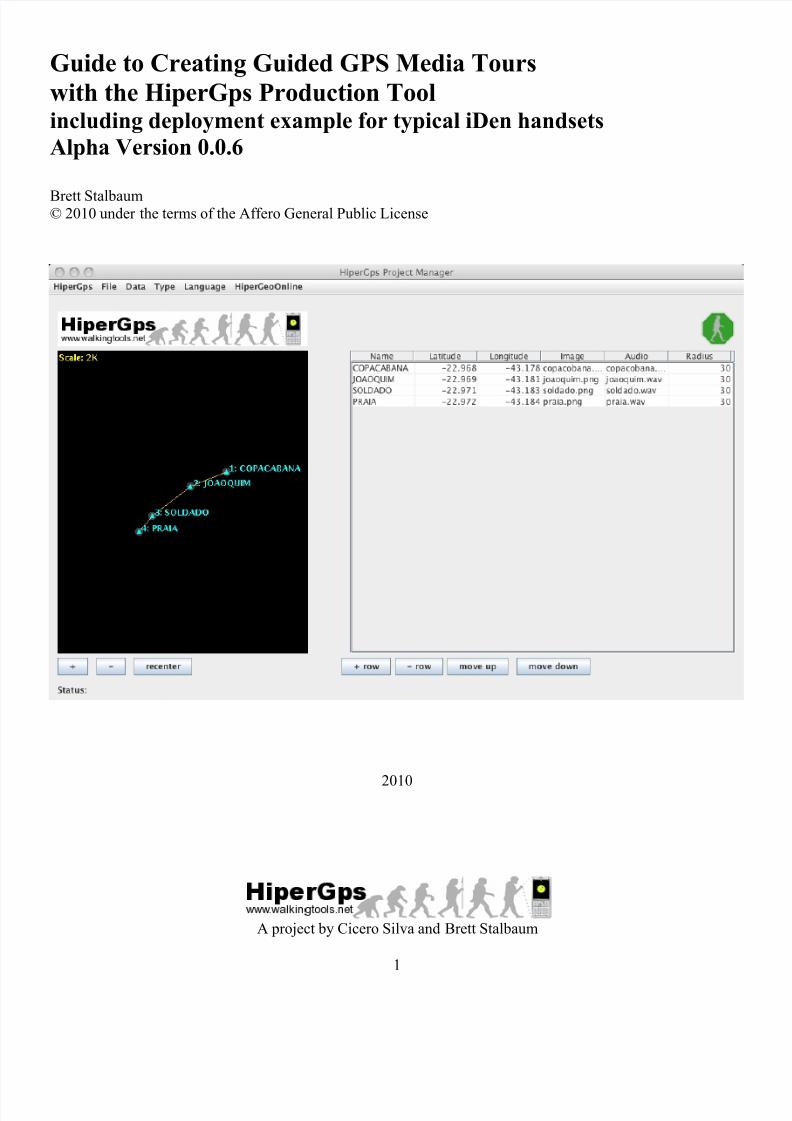
Section 1: Graphical User Interface Illustration (Version 0.0.6)
Note: 0.0.6 shows 6 significant digits in the latitude and longitude fields, but I have not made new screen shots.
3

8/4/2019 Hi Per Gps Guide
http://slidepdf.com/reader/full/hi-per-gps-guide 4/43
Section 2: Downloading and Running HiperGps
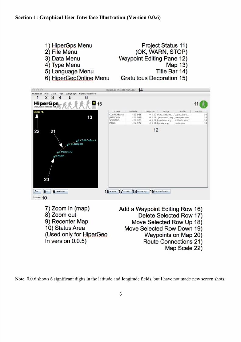
Step 1: Begin by downloading the latest distribution of the WalkingToolsGpx project fromhttp://sourceforge.net/projects/walkingtoolsgpx. Save the .zip distribution to a
convenient place and unzip it. (This version of the documentation was created with version 0.0.5.)
Step 2: Find the JAR file (WalkingToolsGpx.jar), and double click it. If any recent version of the java runtime
system is installed on your computer, (it would be highly unusual if it were not), you should see the HiperGpsApplication running in its own window. See http://java.sun.com if you are having any problems
running the java application.
4
8/4/2019 Hi Per Gps Guide
http://slidepdf.com/reader/full/hi-per-gps-guide 5/43
Section 3: The HiperGps Project Manager Quick Start
Section 3 provides a very quick version of creating a HiperGps project. Section 4 describes the theory and many
more details of the HiperGps GUI, and later sections deal with data collection and management, as well as
deploying applications to compatible devices. Let's step through the creation of a simple project:
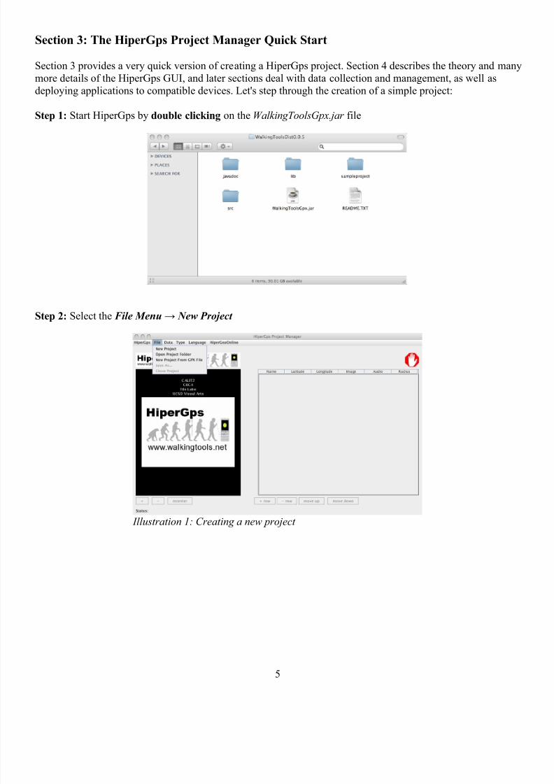
Step 1: Start HiperGps by double clicking on the WalkingToolsGpx.jar file
Step 2: Select the File Menu → New Project
5
Illustration 1: Creating a new project
8/4/2019 Hi Per Gps Guide
http://slidepdf.com/reader/full/hi-per-gps-guide 6/43
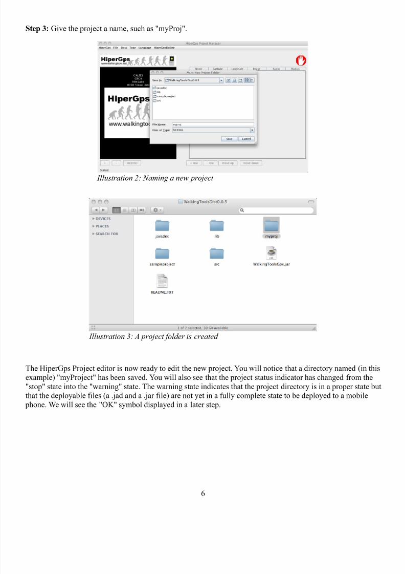
Step 3: Give the project a name, such as "myProj".
The HiperGps Project editor is now ready to edit the new project. You will notice that a directory named (in this
example) "myProject" has been saved. You will also see that the project status indicator has changed from the
"stop" state into the "warning" state. The warning state indicates that the project directory is in a proper state butthat the deployable files (a .jad and a .jar file) are not yet in a fully complete state to be deployed to a mobile
phone. We will see the "OK" symbol displayed in a later step.
6
Illustration 2: Naming a new project
Illustration 3: A project folder is created
8/4/2019 Hi Per Gps Guide
http://slidepdf.com/reader/full/hi-per-gps-guide 7/43
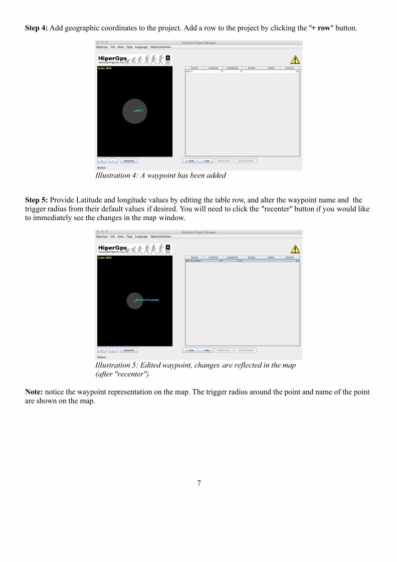
Step 4: Add geographic coordinates to the project. Add a row to the project by clicking the "+ row" button.
Step 5: Provide Latitude and longitude values by editing the table row, and alter the waypoint name and the
trigger radius from their default values if desired. You will need to click the "recenter" button if you would liketo immediately see the changes in the map window.
Note: notice the waypoint representation on the map. The trigger radius around the point and name of the pointare shown on the map.
7
Illustration 4: A waypoint has been added
Illustration 5: Edited waypoint, changes are reflected in the map
(after "recenter")

8/4/2019 Hi Per Gps Guide
http://slidepdf.com/reader/full/hi-per-gps-guide 8/43
Step 6: A waypoint can not be complete until an image file and an audio file are associated with it, and a project
can not be complete until there are at least two waypoints. Use the Data menu, Data → Ingest Image and
Data → Ingest Audio to select appropriate files. Multiple files may be selected as of verson 0.0.6 (See also
Section 5.) Note that there is a sample-files folder inside of the project folder that contains various sample
files useful for learning purposes. When you select any file (no matter where it is in your directory system) it
will be copied into your project directory. More on the implications of this, and the structure of a project folder,in later sections.
Repeat these steps for any number of image and audio files (as you might expect, maintaining one image andaudio file per row is a best practice), until all of your planned waypoints are represented.
8
Illustration 6: Ingesting a file
Illustration 7: Selecting "copacobana.png" for ingestion

8/4/2019 Hi Per Gps Guide
http://slidepdf.com/reader/full/hi-per-gps-guide 9/43
Step 7: You will not notice any immediate differences! The files are simply ingested (copied) into the project,
and now they must be associated with a waypoint. Simply click on the cell that you wish to edit, and you will beable to select the file that you wish to associate with each individual waypoint.
Steps 8 through N: Repeat this process until you have the desired number of waypoints in your locative tour. Afinished project looks something like the illustration below. Note that once each of the waypoint coordinate
pairs (latitude and longitude) is associated with an image and an audio file, and that the project status indicator
has changed to the "OK" (walking figure) status. You are done with your project! The .jad and .jar file inside of
the myproj/deploy is ready to deploy to the phone. (Techniques vary, see section 7.) When HiperGps is run
on the mobile (more technically, if the HiperGps Java MIDlet is deployed and executed on a compatible mobile phone), the image and the audio file will be triggered within radius meters of the waypoint.
9
Illustration 8: Selecting a media file to be associated with awaypoint
Illustration 9: Finished project
8/4/2019 Hi Per Gps Guide
http://slidepdf.com/reader/full/hi-per-gps-guide 10/43
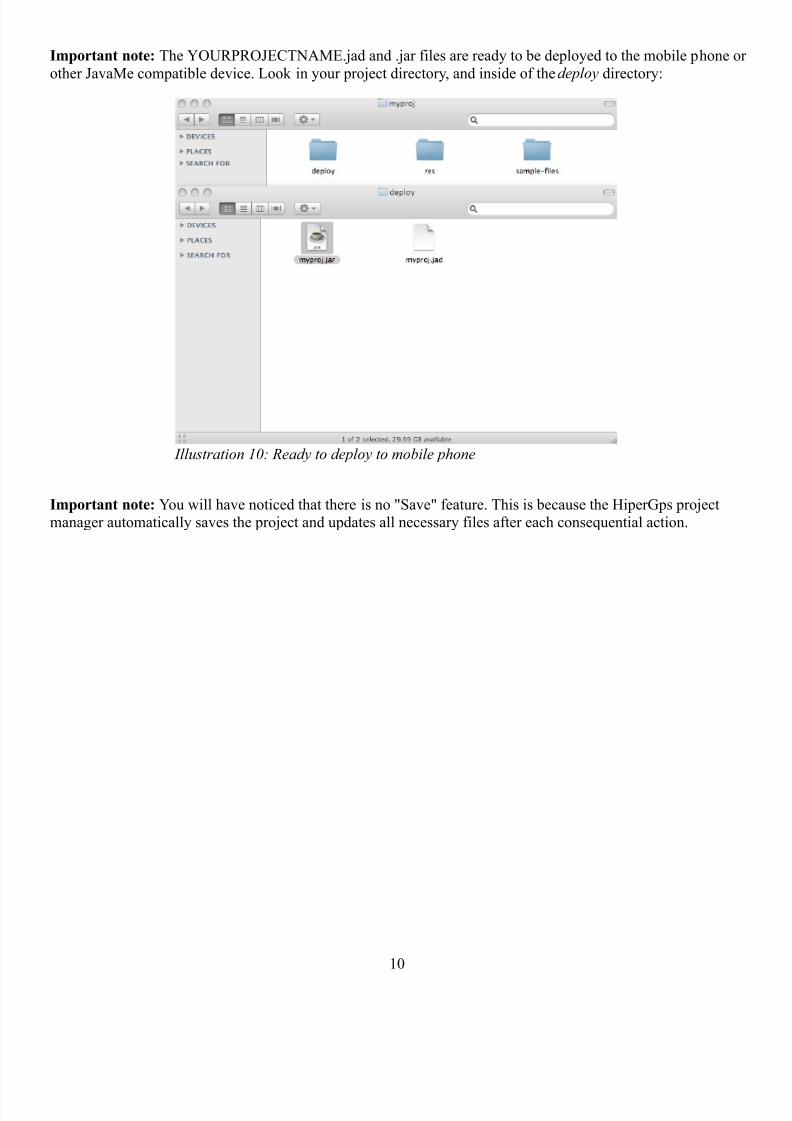
Important note: The YOURPROJECTNAME.jad and .jar files are ready to be deployed to the mobile phone or
other JavaMe compatible device. Look in your project directory, and inside of the deploy directory:
Important note: You will have noticed that there is no "Save" feature. This is because the HiperGps projectmanager automatically saves the project and updates all necessary files after each consequential action.
10
Illustration 10: Ready to deploy to mobile phone
8/4/2019 Hi Per Gps Guide
http://slidepdf.com/reader/full/hi-per-gps-guide 11/43
Section 4: Freeform Tours and Routes
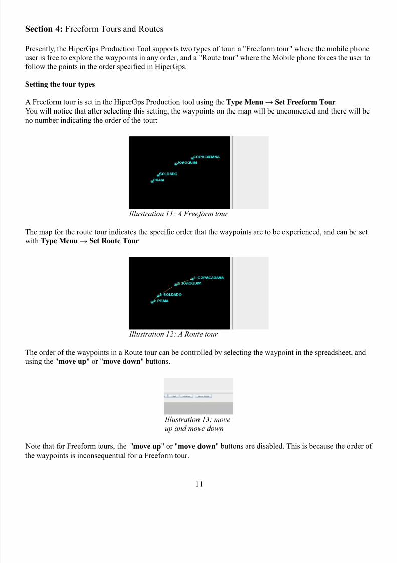
Presently, the HiperGps Production Tool supports two types of tour: a "Freeform tour" where the mobile phone
user is free to explore the waypoints in any order, and a "Route tour" where the Mobile phone forces the user to
follow the points in the order specified in HiperGps.
Setting the tour types
A Freeform tour is set in the HiperGps Production tool using the Type Menu → Set Freeform Tour
You will notice that after selecting this setting, the waypoints on the map will be unconnected and there will be
no number indicating the order of the tour:
The map for the route tour indicates the specific order that the waypoints are to be experienced, and can be set
with Type Menu → Set Route Tour
The order of the waypoints in a Route tour can be controlled by selecting the waypoint in the spreadsheet, and
using the "move up" or "move down" buttons.
Note that for Freeform tours, the "move up" or "move down" buttons are disabled. This is because the order of
the waypoints is inconsequential for a Freeform tour.
11
Illustration 13: move
up and move down
Illustration 11: A Freeform tour
Illustration 12: A Route tour
8/4/2019 Hi Per Gps Guide
http://slidepdf.com/reader/full/hi-per-gps-guide 12/43
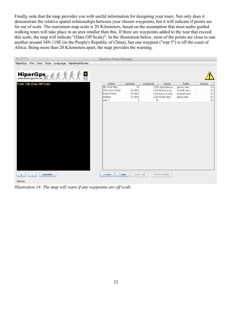
Finally, note that the map provides you with useful information for designing your tours. Not only does it
demonstrate the relative spatial relationships between your chosen waypoints, but it will indicate if points arefar out of scale. The maximum map scale is 20 Kilometers, based on the assumption that most audio guided
walking tours will take place in an area smaller than this. If there are waypoints added to the tour that exceed
this scale, the map will indicate "(Data Off Scale)". In the illustration below, most of the points are close to oneanother around 34N 118E (in the People's Republic of China), but one waypont ("wpt 5") is off the coast of
Africa. Being more than 20 Kilometers apart, the map provides the warning.
12
Illustration 14: The map will warn if any waypoints are off scale
8/4/2019 Hi Per Gps Guide
http://slidepdf.com/reader/full/hi-per-gps-guide 13/43
Section 5: Working with Media
Presently, the 0.0.6 version of the HiperGps project manager only supports three media types: 1) A single PNG
(.png) image per waypoint that will be displayed upon arrival the specified waypoint, and 2) and single audio
file in the WAVE (.wav) or MP3 (.mp3) format that will be triggered upon arrival at the specified waypoint.How to acquire and produce your images and audio files is beyond the scope of this document, but free software
such as GIMP (http://www.gimp.org/) and Audacity (http://audacity.sourceforge.net/) are well suited to the task
of producing HiperGps projects. Note that some simple phones (like most Motorola iDen handsets), only
support 8-bit, 8khz, PCM wav files.
Issues and advice for media:
The mobile phones to which a HiperGps project may be deployed are a very heterogeneous group, ranging
greatly in memory, processing speed and capabilities. The minimum API support for a HiperGps Project is that
the phone support CLDC 1.1, MIDP 2.0, and JSR 179: The Location API. If your phone supports theseminimum standards, you should be able to get a HiperGps project to run it provided the phone has not been
disabled by your carrier such that you can not install software of your choice on your very own phone.
But there are many further considerations, listed in no particular order below:
• While MIDP allows for many media types, the minimum standard (relevant to the current version of HiperGps) is that they support 8-bit, 8KHZ, Mono PCM WAVE audio (the absolute lowest quality possible), and PNG files but without support for advanced PNG features such as animation. Many of the
Motorola iDen handsets (the i425 and i450, for example) only support these most minimal file types. So
if you are getting unexplained exceptions (errors) when you run the software on your mobile, this is alikely source of the difficulty. More expensive phones such as the Nokia N Series can play MP3 audio,
and HiperGps will allow injesting of MP3 files for these more capable phones. But using these more
advanced file types also breaks HiperGps on many lesser handsets. Keep this in mind.
• The wtj2me HiperGps MIDlet's will resize images down to the phone's screen size at startup. This hastwo consequences:
1. Generally, images that are 320x240 in size are ideal for HiperGps projects, especially because
very few mobile devices have a larger screen.2. The MIDlets resize the images on start-up, thus the smaller the images, the faster the start-up. If
you know the screen size of the device you are targeting, consider resizing all of your images to
that size. Many low-end iDen handsets such at the i450, i455, i425, and i290 have 130x130 pixelscreens of which 30 vertical pixels are used for the soft buttons, making a defacto 130x100 pixel
image size the most efficient. Once again, we have to consider the target handset.
• In the 0.0.6 version, the images are automatically stretched to fit the screen, which can disturb the perspective of your images. Experiment and develop your project accordingly, perhaps adding your own
letter boxes to your source images if you desire a portrait mode. (This may be addressed in a future
version.)
• The HiperGps Project Manager truly "ingests" or copies the image and audio files you select under Data
→ Ingest Image and Data → Ingest Audio. This has the consequence that if you wish to change the
images that are deployed to the .jar file, you either have to edit the ingested files directly (your
project directory/res/images or your project directory/res/audio), or you
must delete the media from the project using Data → Delete Image Asset or Data → Delete Audio
Asset and replace them with newly edited, newly ingested versions. (This may be automated in future
versions.) Further, if you are directly editing project files, be sure that HiperGps has the opportunity torewrite the .jad and .jar files. You can do this by opening the project and making some trivial change,
such as switching an image or changing a radius value. This will trigger a rewrite.
13

8/4/2019 Hi Per Gps Guide
http://slidepdf.com/reader/full/hi-per-gps-guide 14/43
Walkingtools.net continues to update the HiperGps software and all of the WalkingTools Reference APIs. Please
feel free to contact us with ideas, bug reports, errata, and feature requests.
A note on Video:
Yes, we do want to enable video. Video works very differently across various mobile phones, especially phones
of very different memory capabilities. If you are a developer, this is something we would be interested in help
with. We think this will become more natural as we evolve HiperGps to other platforms.
A note on the iPhone:
We are often asked if HiperGps applications can be deployed to the Apple iPhone. For now, the answer "is weare experimenting", but we are interested in working with anyone who wishes to produce an open source
HiperGps client for the iPhone platform.
14

8/4/2019 Hi Per Gps Guide
http://slidepdf.com/reader/full/hi-per-gps-guide 15/43
Section 6: Getting Geographic Data points (Waypoints) and Importing Waypoints from
GPX files
The fundamental elements in the design of a GPS guided tour is of course the locations at which the media will
be triggered. The HiperGps project stores its geospatial data and associated media information in a special file,specifically a GPX file with walkingtools.net XML extensions. When you are editing a project with the
HiperGps GUI, the data is automatically stored and updated in this special XML file in your project folder:your project folder/res/gps/hipergps.gpx. You should never edit this file yourself unless you
are sure what you are doing, and never when a project is open in the HiperGpsGui. Nevertheless it can beinstructive to open and read it with a text editor. Here is the file that was produced by the sample project created
above:
<?xml version="1.0" encoding="UTF-8" standalone="no"?>
<gpx xmlns="http://www.topografix.com/GPX/1/1/gpx.xsd" xmlns:xsi="http://www.w3.org/2001/XMLSchema-
instance" creator="WalkingToolsGpx 0.0.5" version="1.1"
xsi:schemaLocation="http://www.topografix.com/GPX/1/1 http://www.topografix.com/GPX/1/1/gpx.xsd">
<metadata>
<author>
<name>The Walking Tools HiperGps Project</name>
</author>
<copyright author="The Walking Tools HiperGps Project">
<license>http://www.fsf.org/licensing/licenses/agpl-3.0.html</license></copyright>
<link href="http://www.walkingtools.net">
<text>Home of WalkingTools</text>
<type>text/html</type>
</link>
<bounds maxlat="34.003" maxlon="118.0" minlat="34.0" minlon="118.0"/>
</metadata>
<wpt lat="34.0" lon="118.0">
<ele>0.0</ele>
<name>My First Waypoint</name>
<extensions>
<wtgpx:wptExtension xmlns:wtgpx="http://www.walkingtools.net/xmlschemas/GpxExtensions/0/0/5"
version="0.0.5" xsi:schemaLocation="http://www.walkingtools.net/xmlschemas/GpxExtensions/0/0/5
http://www.walkingtools.net/xmlschemas/GpxExtensions/0/0/5/walkingtools.xsd">
<wtgpx:radius>20</wtgpx:radius><wtgpx:audio>
<wtgpx:fileName>goose.wav</wtgpx:fileName>
</wtgpx:audio>
<wtgpx:image>
<wtgpx:fileName>copacobana.png</wtgpx:fileName>
</wtgpx:image>
</wtgpx:wptExtension>
</extensions>
</wpt>
<wpt lat="34.001" lon="118.0">
<ele>0.0</ele>
<name>The Gray Knoll</name>
<extensions>
<wtgpx:wptExtension xmlns:wtgpx="http://www.walkingtools.net/xmlschemas/GpxExtensions/0/0/5"
version="0.0.5" xsi:schemaLocation="http://www.walkingtools.net/xmlschemas/GpxExtensions/0/0/5http://www.walkingtools.net/xmlschemas/GpxExtensions/0/0/5/walkingtools.xsd">
<wtgpx:radius>30</wtgpx:radius>
<wtgpx:audio>
<wtgpx:fileName>deadb.wav</wtgpx:fileName>
</wtgpx:audio>
<wtgpx:image>
<wtgpx:fileName>deadb.png</wtgpx:fileName>
</wtgpx:image>
</wtgpx:wptExtension>
</extensions>
</wpt>
15
8/4/2019 Hi Per Gps Guide
http://slidepdf.com/reader/full/hi-per-gps-guide 16/43
<wpt lat="34.002" lon="118.0">
<ele>0.0</ele>
<name>Rush Creek</name>
<extensions>
<wtgpx:wptExtension xmlns:wtgpx="http://www.walkingtools.net/xmlschemas/GpxExtensions/0/0/5"
version="0.0.5" xsi:schemaLocation="http://www.walkingtools.net/xmlschemas/GpxExtensions/0/0/5
http://www.walkingtools.net/xmlschemas/GpxExtensions/0/0/5/walkingtools.xsd">
<wtgpx:radius>30</wtgpx:radius>
<wtgpx:audio>
<wtgpx:fileName>eastcrk.wav</wtgpx:fileName>
</wtgpx:audio>
<wtgpx:image><wtgpx:fileName>eastcrk.png</wtgpx:fileName>
</wtgpx:image>
</wtgpx:wptExtension>
</extensions>
</wpt>
<wpt lat="34.003" lon="118.0">
<ele>0.0</ele>
<name>Bunker</name>
<extensions>
<wtgpx:wptExtension xmlns:wtgpx="http://www.walkingtools.net/xmlschemas/GpxExtensions/0/0/5"
version="0.0.5" xsi:schemaLocation="http://www.walkingtools.net/xmlschemas/GpxExtensions/0/0/5
http://www.walkingtools.net/xmlschemas/GpxExtensions/0/0/5/walkingtools.xsd">
<wtgpx:radius>30</wtgpx:radius>
<wtgpx:audio>
<wtgpx:fileName>elcap.wav</wtgpx:fileName></wtgpx:audio>
<wtgpx:image>
<wtgpx:fileName>elcap.png</wtgpx:fileName>
</wtgpx:image>
</wtgpx:wptExtension>
</extensions>
</wpt>
</gpx>
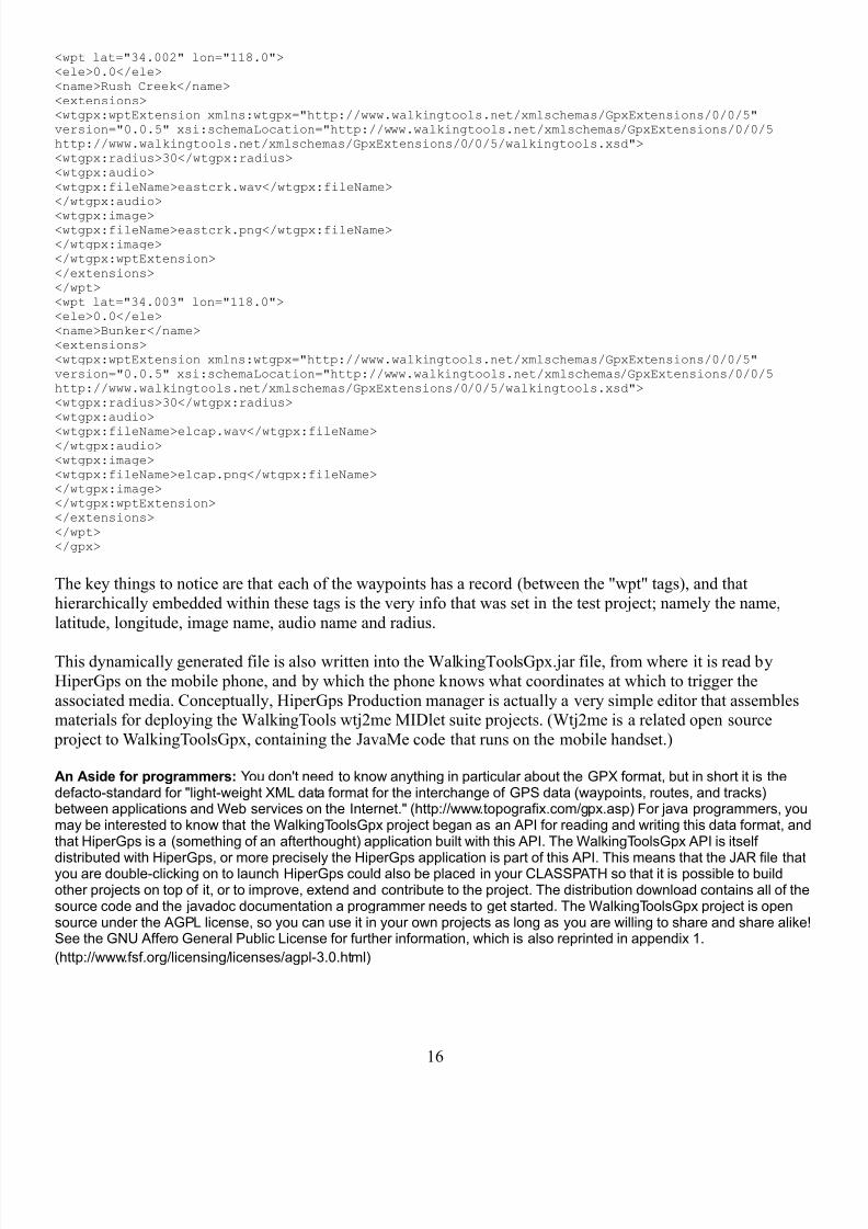
The key things to notice are that each of the waypoints has a record (between the "wpt" tags), and that
hierarchically embedded within these tags is the very info that was set in the test project; namely the name,
latitude, longitude, image name, audio name and radius.
This dynamically generated file is also written into the WalkingToolsGpx.jar file, from where it is read by
HiperGps on the mobile phone, and by which the phone knows what coordinates at which to trigger the
associated media. Conceptually, HiperGps Production manager is actually a very simple editor that assemblesmaterials for deploying the WalkingTools wtj2me MIDlet suite projects. (Wtj2me is a related open source
project to WalkingToolsGpx, containing the JavaMe code that runs on the mobile handset.)
An Aside for programmers: You don't need to know anything in particular about the GPX format, but in short it is thedefacto-standard for "light-weight XML data format for the interchange of GPS data (waypoints, routes, and tracks)between applications and Web services on the Internet." (http://www.topografix.com/gpx.asp) For java programmers, youmay be interested to know that the WalkingToolsGpx project began as an API for reading and writing this data format, andthat HiperGps is a (something of an afterthought) application built with this API. The WalkingToolsGpx API is itself
distributed with HiperGps, or more precisely the HiperGps application is part of this API. This means that the JAR file thatyou are double-clicking on to launch HiperGps could also be placed in your CLASSPATH so that it is possible to buildother projects on top of it, or to improve, extend and contribute to the project. The distribution download contains all of thesource code and the javadoc documentation a programmer needs to get started. The WalkingToolsGpx project is opensource under the AGPL license, so you can use it in your own projects as long as you are willing to share and share alike!See the GNU Affero General Public License for further information, which is also reprinted in appendix 1.
(http://www.fsf.org/licensing/licenses/agpl-3.0.html)
16

8/4/2019 Hi Per Gps Guide
http://slidepdf.com/reader/full/hi-per-gps-guide 17/43
So what? Why should you care?
The main reason to be aware of GPX files is that they have great utility to you, the content producer. The
following question may have occurred to you already: How do you record the Geographic coordinates of thelocations on the earth at which you want to have your media triggered?
There are are any number of approaches you could take; following are a number of scenarios. While the first
two manual methods are fairly tedious each in their own way, they don't require an separate GPS device. The
third scenario uses a standard GPS device to record waypoints and extract them as a useful GPX file that is veryeasy to work with.
Scenario 1: The "On-phone" Gps application as a source of geographic coordinates
First and most basic, you will notice (at some point) that when you install and run the wtj2me MIDlet suite
produced by HiperGps onto an actual phone, that there is also a very simple "GPS" MIDlet included. This isintended to be replaced by a full, on-phone production suite in a later version. But for now, this simple
application will display for you your current latitude and longitude values. In preparing a tour, you could go to
the actual locations that you wish to have media triggered at and record the coordinates in a notebook, and later enter them by hand into a new waypoint row in the HiperGps application. It may be a little tedious, but it is
perfectly effective and very accurate. A disadvantage, if you want to call it that, is that you have to be in-situand on-site to record your waypoint (latitude and longitude) data. But for tour designers, the importance of
being there might be considered to be even more important! Scenario 2 provides a virtual alternative.
Scenario 2:
There are other sources for the the geographic coordinates that you need to author a walking tour, of course.Better maps, for example, will have latitude and longitude in the margins, meaning a modestly skillful map
reader could simply read them! (And making sure that the geodetic datam is WSG84 or at least NAD83.
17
Illustration 15: The
"on-phone" GPS
application
8/4/2019 Hi Per Gps Guide
http://slidepdf.com/reader/full/hi-per-gps-guide 18/43
Warning: many topographic maps will be in some other datum, such as the venerable and historic NAD27,
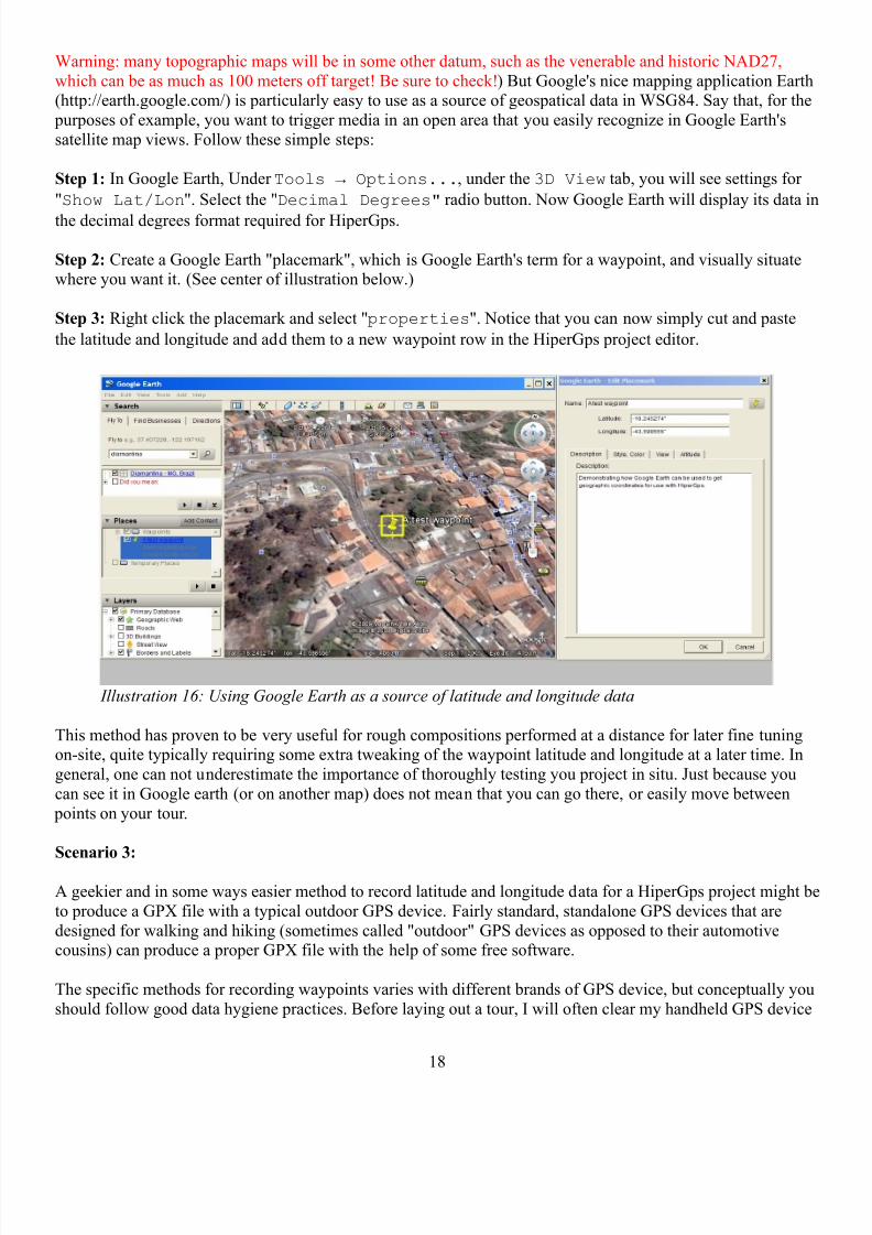
which can be as much as 100 meters off target! Be sure to check!) But Google's nice mapping application Earth(http://earth.google.com/) is particularly easy to use as a source of geospatical data in WSG84. Say that, for the
purposes of example, you want to trigger media in an open area that you easily recognize in Google Earth's
satellite map views. Follow these simple steps:
Step 1: In Google Earth, Under Tools → Options..., under the 3D View tab, you will see settings for
"Show Lat/Lon". Select the "Decimal Degrees" radio button. Now Google Earth will display its data in
the decimal degrees format required for HiperGps.
Step 2: Create a Google Earth "placemark", which is Google Earth's term for a waypoint, and visually situatewhere you want it. (See center of illustration below.)
Step 3: Right click the placemark and select "properties". Notice that you can now simply cut and paste
the latitude and longitude and add them to a new waypoint row in the HiperGps project editor.
This method has proven to be very useful for rough compositions performed at a distance for later fine tuningon-site, quite typically requiring some extra tweaking of the waypoint latitude and longitude at a later time. In
general, one can not underestimate the importance of thoroughly testing you project in situ. Just because you
can see it in Google earth (or on another map) does not mean that you can go there, or easily move between
points on your tour.
Scenario 3:
A geekier and in some ways easier method to record latitude and longitude data for a HiperGps project might be
to produce a GPX file with a typical outdoor GPS device. Fairly standard, standalone GPS devices that are
designed for walking and hiking (sometimes called "outdoor" GPS devices as opposed to their automotivecousins) can produce a proper GPX file with the help of some free software.
The specific methods for recording waypoints varies with different brands of GPS device, but conceptually you
should follow good data hygiene practices. Before laying out a tour, I will often clear my handheld GPS device
18
Illustration 16: Using Google Earth as a source of latitude and longitude data

8/4/2019 Hi Per Gps Guide
http://slidepdf.com/reader/full/hi-per-gps-guide 19/43
of all previously recorded data. Then, just as with the mobile phone in scenario one discussed above, I walk to
the places where I want to have media triggered, and following the instructions for my particular device, Irecord the waypoint into the device's memory. At this point, I could follow the procedure specified in Scenario
One: I could copy the data I need off of my GPS device's screen. But it may be much easier to save a GPX file
on a computer and import it directly into the HiperGps Production Manager.
How to do this varies widely, but certain free software applications can make the process very simple. G7towin
is Garmin, Magellan, & Lowrance/Eagle GPS Interface Software for the PC
written by Ron Henderson. One of the nice features of this simple to use freeware (for which we all owe Ron adebt of thanks!) is that it is capable of downloading the GPS coordinates you recorded in your GPS device and
saving them in the venerable GPX file format. It can be downloaded at
http://gpsinformation.org/ronh/g7towin2.html.
19
Illustration 17: Ron Henderson's g7towin GPS utility is a nice tool to have in your toolkit
8/4/2019 Hi Per Gps Guide
http://slidepdf.com/reader/full/hi-per-gps-guide 20/43
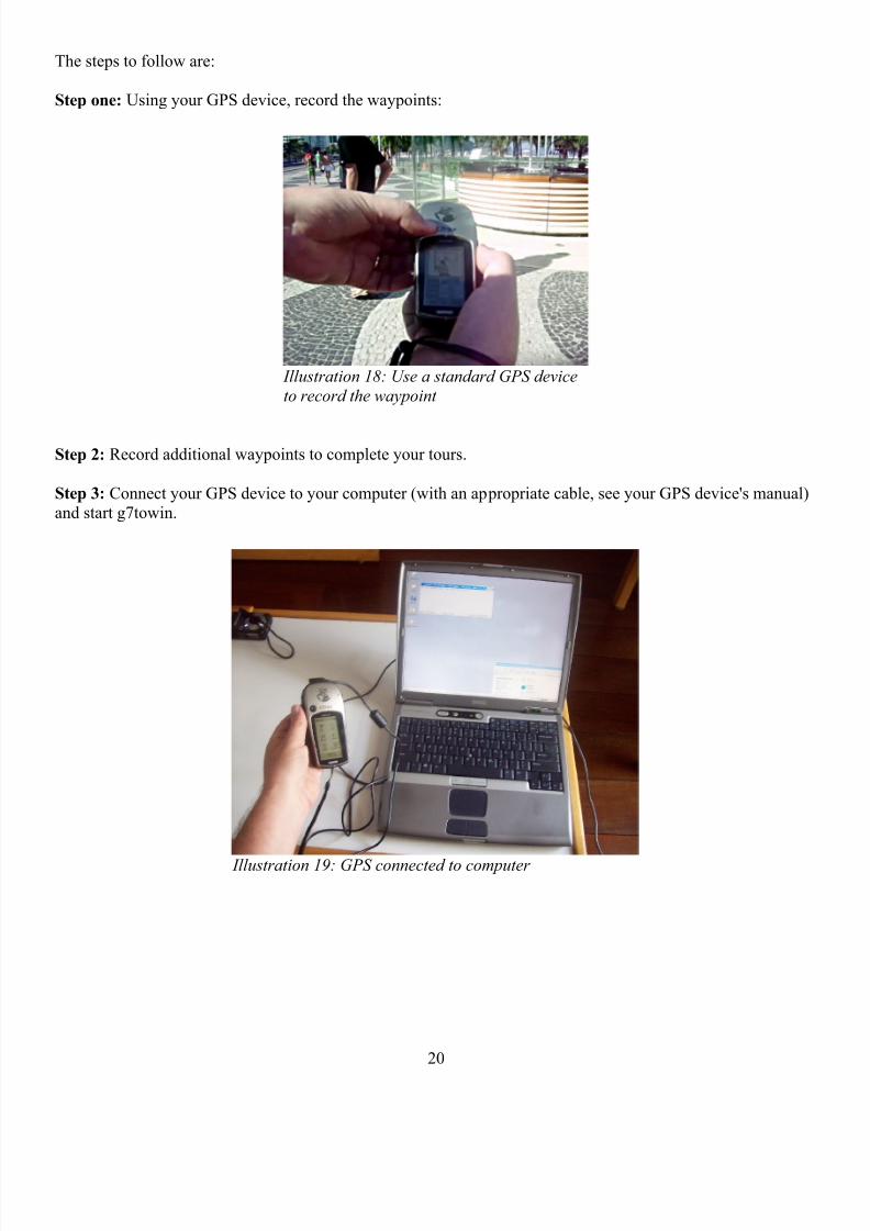
The steps to follow are:
Step one: Using your GPS device, record the waypoints:
Step 2: Record additional waypoints to complete your tours.
Step 3: Connect your GPS device to your computer (with an appropriate cable, see your GPS device's manual)and start g7towin.
20
Illustration 18: Use a standard GPS device
to record the waypoint
Illustration 19: GPS connected to computer
8/4/2019 Hi Per Gps Guide
http://slidepdf.com/reader/full/hi-per-gps-guide 21/43
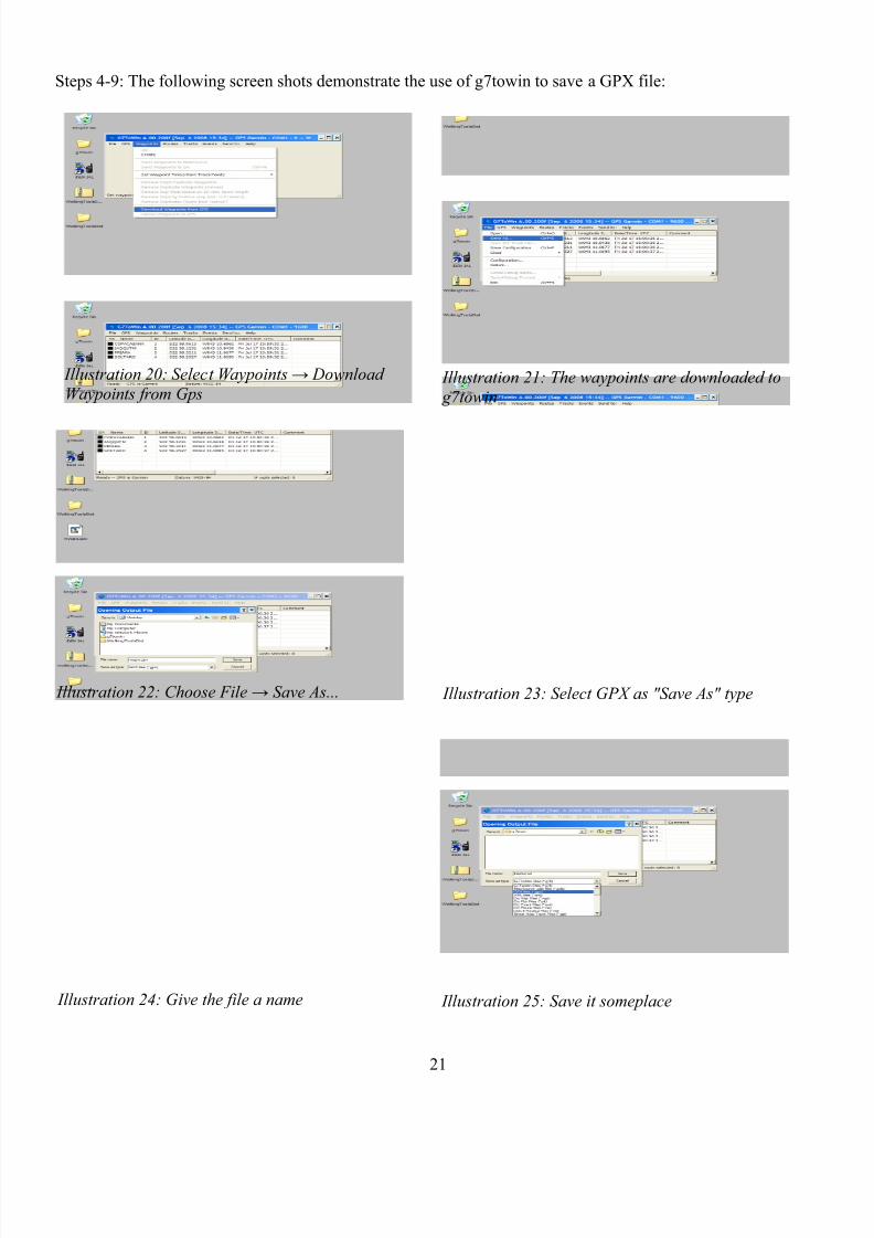
Steps 4-9: The following screen shots demonstrate the use of g7towin to save a GPX file:
21
Illustration 21: The waypoints are downloaded to
g7towin
Illustration 22: Choose File → Save As... Illustration 23: Select GPX as "Save As" type
Illustration 25: Save it someplace
Illustration 20: Select Waypoints → Download
Waypoints from Gps
Illustration 24: Give the file a name
8/4/2019 Hi Per Gps Guide
http://slidepdf.com/reader/full/hi-per-gps-guide 22/43
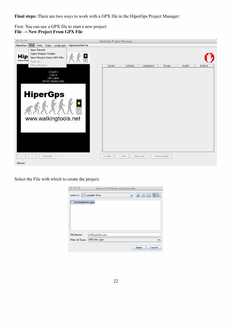
Final steps: There are two ways to work with a GPX file in the HiperGps Project Manager:
First: You can use a GPX file to start a new project:
File → New Project From GPX File
Select the File with which to create the project:
22

8/4/2019 Hi Per Gps Guide
http://slidepdf.com/reader/full/hi-per-gps-guide 23/43
Next give the project a name and save it somewhere:
And now you are ready to add images and audio, or otherwise edit the project (Section 5)
23

8/4/2019 Hi Per Gps Guide
http://slidepdf.com/reader/full/hi-per-gps-guide 24/43
Second Method: Add GPX waypoints to an existing project
Simply use Data Menu → Import GPX Waypoints
And select the desired GPX file:
24
8/4/2019 Hi Per Gps Guide
http://slidepdf.com/reader/full/hi-per-gps-guide 25/43
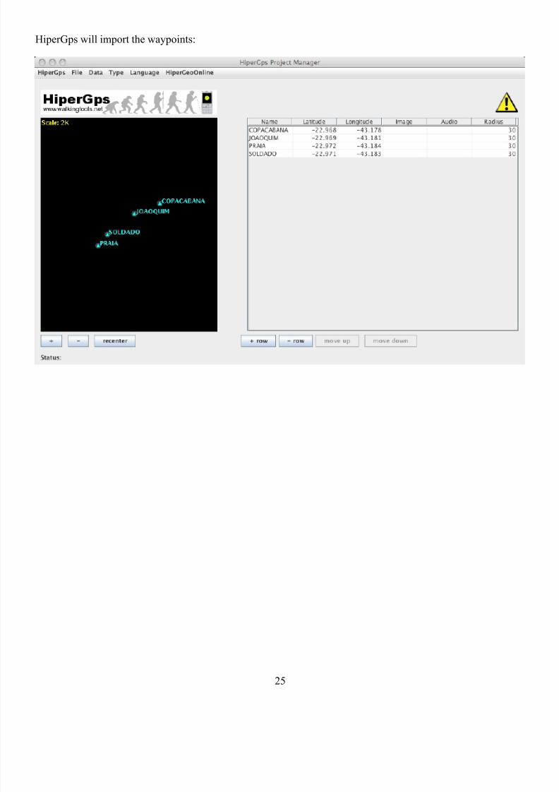
HiperGps will import the waypoints:
25
8/4/2019 Hi Per Gps Guide
http://slidepdf.com/reader/full/hi-per-gps-guide 26/43
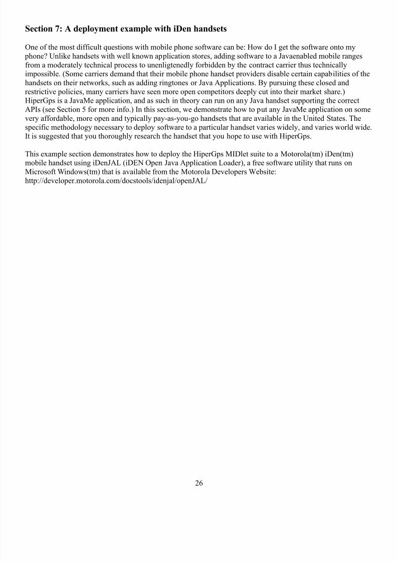
Section 7: A deployment example with iDen handsets
One of the most difficult questions with mobile phone software can be: How do I get the software onto my
phone? Unlike handsets with well known application stores, adding software to a Javaenabled mobile ranges
from a moderately technical process to unenligtenedly forbidden by the contract carrier thus technicallyimpossible. (Some carriers demand that their mobile phone handset providers disable certain capabilities of the
handsets on their networks, such as adding ringtones or Java Applications. By pursuing these closed and
restrictive policies, many carriers have seen more open competitors deeply cut into their market share.)
HiperGps is a JavaMe application, and as such in theory can run on any Java handset supporting the correctAPIs (see Section 5 for more info.) In this section, we demonstrate how to put any JavaMe application on some
very affordable, more open and typically pay-as-you-go handsets that are available in the United States. The
specific methodology necessary to deploy software to a particular handset varies widely, and varies world wide.It is suggested that you thoroughly research the handset that you hope to use with HiperGps.
This example section demonstrates how to deploy the HiperGps MIDlet suite to a Motorola(tm) iDen(tm)mobile handset using iDenJAL (iDEN Open Java Application Loader), a free software utility that runs on
Microsoft Windows(tm) that is available from the Motorola Developers Website:
http://developer.motorola.com/docstools/idenjal/openJAL/
26
8/4/2019 Hi Per Gps Guide
http://slidepdf.com/reader/full/hi-per-gps-guide 27/43
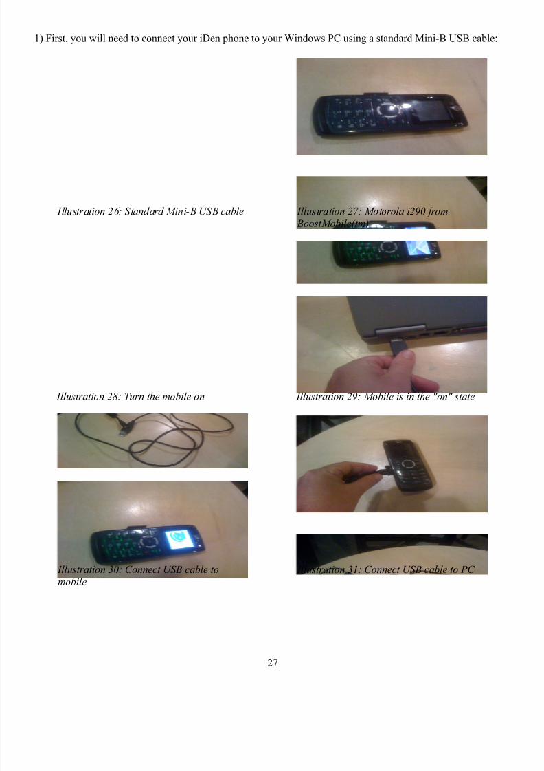
1) First, you will need to connect your iDen phone to your Windows PC using a standard Mini-B USB cable:
27
Illustration 26: Standard Mini-B USB cable Illustration 27: Motorola i290 from BoostMobile(tm)
Illustration 28: Turn the mobile on Illustration 29: Mobile is in the "on" state
Illustration 30: Connect USB cable to
mobile
Illustration 31: Connect USB cable to PC
8/4/2019 Hi Per Gps Guide
http://slidepdf.com/reader/full/hi-per-gps-guide 28/43
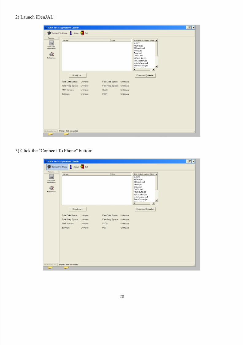
2) Launch iDenJAL:
3) Click the "Connect To Phone" button:
28
8/4/2019 Hi Per Gps Guide
http://slidepdf.com/reader/full/hi-per-gps-guide 29/43
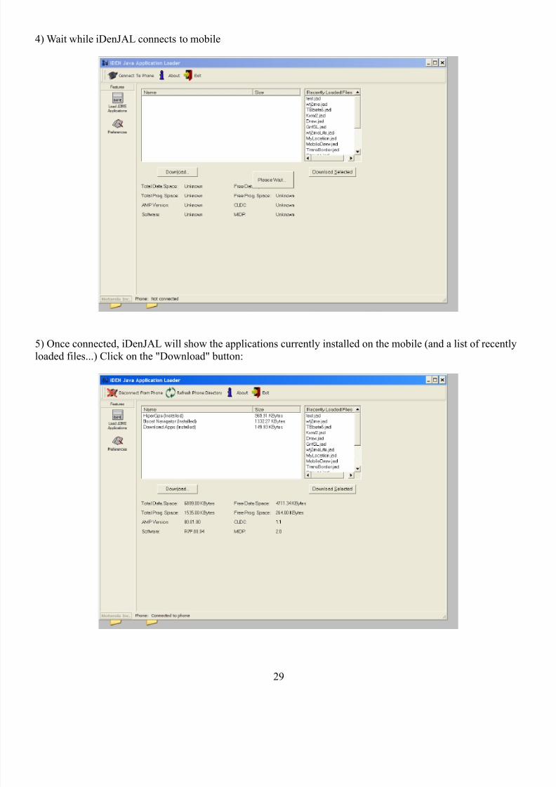
4) Wait while iDenJAL connects to mobile
5) Once connected, iDenJAL will show the applications currently installed on the mobile (and a list of recently
loaded files...) Click on the "Download" button:
29
8/4/2019 Hi Per Gps Guide
http://slidepdf.com/reader/full/hi-per-gps-guide 30/43
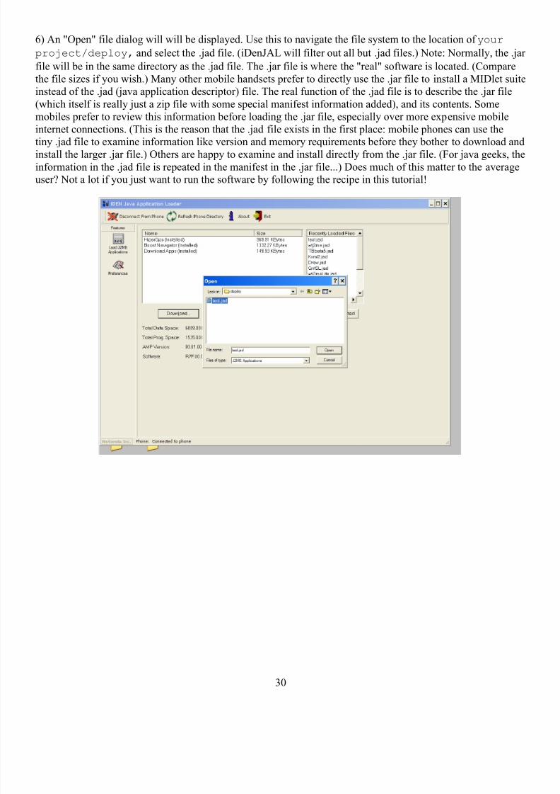
6) An "Open" file dialog will will be displayed. Use this to navigate the file system to the location of your
project/deploy, and select the .jad file. (iDenJAL will filter out all but .jad files.) Note: Normally, the .jar
file will be in the same directory as the .jad file. The .jar file is where the "real" software is located. (Compare
the file sizes if you wish.) Many other mobile handsets prefer to directly use the .jar file to install a MIDlet suiteinstead of the .jad (java application descriptor) file. The real function of the .jad file is to describe the .jar file
(which itself is really just a zip file with some special manifest information added), and its contents. Some
mobiles prefer to review this information before loading the .jar file, especially over more expensive mobile
internet connections. (This is the reason that the .jad file exists in the first place: mobile phones can use the
tiny .jad file to examine information like version and memory requirements before they bother to download andinstall the larger .jar file.) Others are happy to examine and install directly from the .jar file. (For java geeks, the
information in the .jad file is repeated in the manifest in the .jar file...) Does much of this matter to the averageuser? Not a lot if you just want to run the software by following the recipe in this tutorial!
30
8/4/2019 Hi Per Gps Guide
http://slidepdf.com/reader/full/hi-per-gps-guide 31/43
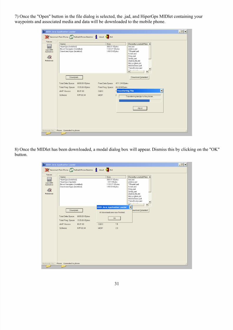
7) Once the "Open" button in the file dialog is selected, the .jad, and HiperGps MIDlet containing your
waypoints and associated media and data will be downloaded to the mobile phone.
8) Once the MIDlet has been downloaded, a modal dialog box will appear. Dismiss this by clicking on the "OK" button.
31
8/4/2019 Hi Per Gps Guide
http://slidepdf.com/reader/full/hi-per-gps-guide 32/43
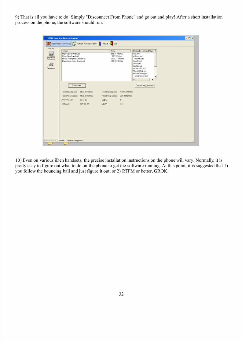
9) That is all you have to do! Simply "Disconnect From Phone" and go out and play! After a short installation
process on the phone, the software should run.
10) Even on various iDen handsets, the precise installation instructions on the phone will vary. Normally, it is
pretty easy to figure out what to do on the phone to get the software running. At this point, it is suggested that 1)
you follow the bouncing ball and just figure it out, or 2) RTFM or better, GROK.
32

8/4/2019 Hi Per Gps Guide
http://slidepdf.com/reader/full/hi-per-gps-guide 33/43
Section 8: Experimental HiperGeoOnline Features
HiperGeoOnline represents a suite of services made available by the Walkingtools server packages.
(WalkingToolsServer) A current application of the WalkingToolsServer API’s is to support the internet sharing
of the mediated walks and routes made with HiperGps. Beginning with version 0.0.5 of the WalkingtoolsReference APIs, and in support of the Edith Russ House Landscape 2.0 exhibition, a HiperGeo test server has
been set up at: http://computingarts.ucsd.edu/~bstalbaum/hipergeoonline. Users can create a login there that
allow them to upload their walking tour creations to be shared with HiperGeoSearch. (A WalkingToolsJavaMe
application that allows mobile phone users to search for content in their area.)
Important note: HiperGeoOnline is not intended to be a permanent service located at the above url, though it
will remain the server for testing HiperGeoOnline at least through version 0.0.5 or 0.0.6. HiperGeoOnline is being developed as APIs that can be used on any internet server to support the sharing of user created walking
content.
All of the Walkingtools Reference APIs remain constantly under development. Currently, we think of them as
not only Alpha versions, but very Alpha versions.
33
8/4/2019 Hi Per Gps Guide
http://slidepdf.com/reader/full/hi-per-gps-guide 34/43
Appendix 1 - GNU AFFERO GENERAL PUBLIC LICENSE
GNU AFFERO GENERAL PUBLIC LICENSE
Version 3, 19 November 2007
Copyright © 2007 Free Software Foundation, Inc. <http://fsf.org/>
Everyone is permitted to copy and distribute verbatim copies of this license document, but changing it is notallowed.
Preamble
The GNU Affero General Public License is a free, copyleft license for software and other kinds of works,
specifically designed to ensure cooperation with the community in the case of network server software.
The licenses for most software and other practical works are designed to take away your freedom to share and
change the works. By contrast, our General Public Licenses are intended to guarantee your freedom to share andchange all versions of a program--to make sure it remains free software for all its users.
When we speak of free software, we are referring to freedom, not price. Our General Public Licenses are
designed to make sure that you have the freedom to distribute copies of free software (and charge for them if
you wish), that you receive source code or can get it if you want it, that you can change the software or use pieces of it in new free programs, and that you know you can do these things.
Developers that use our General Public Licenses protect your rights with two steps: (1) assert copyright on the
software, and (2) offer you this License which gives you legal permission to copy, distribute and/or modify the
software.
A secondary benefit of defending all users' freedom is that improvements made in alternate versions of the program, if they receive widespread use, become available for other developers to incorporate. Many
developers of free software are heartened and encouraged by the resulting cooperation. However, in the case of
software used on network servers, this result may fail to come about. The GNU General Public License permitsmaking a modified version and letting the public access it on a server without ever releasing its source code to
the public.
The GNU Affero General Public License is designed specifically to ensure that, in such cases, the modified
source code becomes available to the community. It requires the operator of a network server to provide thesource code of the modified version running there to the users of that server. Therefore, public use of a modified
version, on a publicly accessible server, gives the public access to the source code of the modified version.
An older license, called the Affero General Public License and published by Affero, was designed to accomplish
similar goals. This is a different license, not a version of the Affero GPL, but Affero has released a new versionof the Affero GPL which permits relicensing under this license.
The precise terms and conditions for copying, distribution and modification follow.
TERMS AND CONDITIONS
0. Definitions.
"This License" refers to version 3 of the GNU Affero General Public License.
"Copyright" also means copyright-like laws that apply to other kinds of works, such as semiconductor masks.
"The Program" refers to any copyrightable work licensed under this License. Each licensee is addressed as"you". "Licensees" and "recipients" may be individuals or organizations.
34
8/4/2019 Hi Per Gps Guide
http://slidepdf.com/reader/full/hi-per-gps-guide 35/43
To "modify" a work means to copy from or adapt all or part of the work in a fashion requiring copyright
permission, other than the making of an exact copy. The resulting work is called a "modified version" of theearlier work or a work "based on" the earlier work.
A "covered work" means either the unmodified Program or a work based on the Program.
To "propagate" a work means to do anything with it that, without permission, would make you directly or
secondarily liable for infringement under applicable copyright law, except executing it on a computer or
modifying a private copy. Propagation includes copying, distribution (with or without modification), making
available to the public, and in some countries other activities as well.
To "convey" a work means any kind of propagation that enables other parties to make or receive copies. Mere
interaction with a user through a computer network, with no transfer of a copy, is not conveying.
An interactive user interface displays "Appropriate Legal Notices" to the extent that it includes a convenient and prominently visible feature that (1) displays an appropriate copyright notice, and (2) tells the user that there is
no warranty for the work (except to the extent that warranties are provided), that licensees may convey the work
under this License, and how to view a copy of this License. If the interface presents a list of user commands or
options, such as a menu, a prominent item in the list meets this criterion.
1. Source Code.
The "source code" for a work means the preferred form of the work for making modifications to it. "Objectcode" means any non-source form of a work.
A "Standard Interface" means an interface that either is an official standard defined by a recognized standards
body, or, in the case of interfaces specified for a particular programming language, one that is widely used
among developers working in that language.
The "System Libraries" of an executable work include anything, other than the work as a whole, that (a) isincluded in the normal form of packaging a Major Component, but which is not part of that Major Component,
and (b) serves only to enable use of the work with that Major Component, or to implement a Standard Interface
for which an implementation is available to the public in source code form. A "Major Component", in thiscontext, means a major essential component (kernel, window system, and so on) of the specific operating
system (if any) on which the executable work runs, or a compiler used to produce the work, or an object codeinterpreter used to run it.
The "Corresponding Source" for a work in object code form means all the source code needed to generate,install, and (for an executable work) run the object code and to modify the work, including scripts to control
those activities. However, it does not include the work's System Libraries, or general-purpose tools or generally
available free programs which are used unmodified in performing those activities but which are not part of the
work. For example, Corresponding Source includes interface definition files associated with source files for thework, and the source code for shared libraries and dynamically linked subprograms that the work is specifically
designed to require, such as by intimate data communication or control flow between those subprograms and
other parts of the work.
The Corresponding Source need not include anything that users can regenerate automatically from other parts ofthe Corresponding Source.
The Corresponding Source for a work in source code form is that same work.
2. Basic Permissions.
All rights granted under this License are granted for the term of copyright on the Program, and are irrevocable
provided the stated conditions are met. This License explicitly affirms your unlimited permission to run the
35
8/4/2019 Hi Per Gps Guide
http://slidepdf.com/reader/full/hi-per-gps-guide 36/43
unmodified Program. The output from running a covered work is covered by this License only if the output,
given its content, constitutes a covered work. This License acknowledges your rights of fair use or other equivalent, as provided by copyright law.
You may make, run and propagate covered works that you do not convey, without conditions so long as your
license otherwise remains in force. You may convey covered works to others for the sole purpose of having
them make modifications exclusively for you, or provide you with facilities for running those works, providedthat you comply with the terms of this License in conveying all material for which you do not control copyright.
Those thus making or running the covered works for you must do so exclusively on your behalf, under your
direction and control, on terms that prohibit them from making any copies of your copyrighted material outsidetheir relationship with you.
Conveying under any other circumstances is permitted solely under the conditions stated below. Sublicensing is
not allowed; section 10 makes it unnecessary.
3. Protecting Users' Legal Rights From Anti-Circumvention Law.
No covered work shall be deemed part of an effective technological measure under any applicable law fulfilling
obligations under article 11 of the WIPO copyright treaty adopted on 20 December 1996, or similar laws
prohibiting or restricting circumvention of such measures.
When you convey a covered work, you waive any legal power to forbid circumvention of technologicalmeasures to the extent such circumvention is effected by exercising rights under this License with respect to the
covered work, and you disclaim any intention to limit operation or modification of the work as a means of
enforcing, against the work's users, your or third parties' legal rights to forbid circumvention of technologicalmeasures.
4. Conveying Verbatim Copies.
You may convey verbatim copies of the Program's source code as you receive it, in any medium, provided thatyou conspicuously and appropriately publish on each copy an appropriate copyright notice; keep intact all
notices stating that this License and any non-permissive terms added in accord with section 7 apply to the code;
keep intact all notices of the absence of any warranty; and give all recipients a copy of this License along withthe Program.
You may charge any price or no price for each copy that you convey, and you may offer support or warranty
protection for a fee.
5. Conveying Modified Source Versions.
You may convey a work based on the Program, or the modifications to produce it from the Program, in the form
of source code under the terms of section 4, provided that you also meet all of these conditions:
• a) The work must carry prominent notices stating that you modified it, and giving a relevant date.
• b) The work must carry prominent notices stating that it is released under this License and anyconditions added under section 7. This requirement modifies the requirement in section 4 to "keep intact
all notices".
• c) You must license the entire work, as a whole, under this License to anyone who comes into possession
of a copy. This License will therefore apply, along with any applicable section 7 additional terms, to the
whole of the work, and all its parts, regardless of how they are packaged. This License gives no
permission to license the work in any other way, but it does not invalidate such permission if you haveseparately received it.
• d) If the work has interactive user interfaces, each must display Appropriate Legal Notices; however, if
36
8/4/2019 Hi Per Gps Guide
http://slidepdf.com/reader/full/hi-per-gps-guide 37/43
the Program has interactive interfaces that do not display Appropriate Legal Notices, your work need not
make them do so.
A compilation of a covered work with other separate and independent works, which are not by their natureextensions of the covered work, and which are not combined with it such as to form a larger program, in or on a
volume of a storage or distribution medium, is called an "aggregate" if the compilation and its resulting
copyright are not used to limit the access or legal rights of the compilation's users beyond what the individualworks permit. Inclusion of a covered work in an aggregate does not cause this License to apply to the other
parts of the aggregate.
6. Conveying Non-Source Forms.
You may convey a covered work in object code form under the terms of sections 4 and 5, provided that you also
convey the machine-readable Corresponding Source under the terms of this License, in one of these ways:
• a) Convey the object code in, or embodied in, a physical product (including a physical distributionmedium), accompanied by the Corresponding Source fixed on a durable physical medium customarily
used for software interchange.
• b) Convey the object code in, or embodied in, a physical product (including a physical distribution
medium), accompanied by a written offer, valid for at least three years and valid for as long as you offer
spare parts or customer support for that product model, to give anyone who possesses the object codeeither (1) a copy of the Corresponding Source for all the software in the product that is covered by this
License, on a durable physical medium customarily used for software interchange, for a price no morethan your reasonable cost of physically performing this conveying of source, or (2) access to copy the
Corresponding Source from a network server at no charge.
• c) Convey individual copies of the object code with a copy of the written offer to provide theCorresponding Source. This alternative is allowed only occasionally and noncommercially, and only if
you received the object code with such an offer, in accord with subsection 6b.
• d) Convey the object code by offering access from a designated place (gratis or for a charge), and offer
equivalent access to the Corresponding Source in the same way through the same place at no further charge. You need not require recipients to copy the Corresponding Source along with the object code. If
the place to copy the object code is a network server, the Corresponding Source may be on a differentserver (operated by you or a third party) that supports equivalent copying facilities, provided youmaintain clear directions next to the object code saying where to find the Corresponding Source.
Regardless of what server hosts the Corresponding Source, you remain obligated to ensure that it is
available for as long as needed to satisfy these requirements.
• e) Convey the object code using peer-to-peer transmission, provided you inform other peers where the
object code and Corresponding Source of the work are being offered to the general public at no charge
under subsection 6d.
A separable portion of the object code, whose source code is excluded from the Corresponding Source as aSystem Library, need not be included in conveying the object code work.
A "User Product" is either (1) a "consumer product", which means any tangible personal property which isnormally used for personal, family, or household purposes, or (2) anything designed or sold for incorporation
into a dwelling. In determining whether a product is a consumer product, doubtful cases shall be resolved infavor of coverage. For a particular product received by a particular user, "normally used" refers to a typical or
common use of that class of product, regardless of the status of the particular user or of the way in which the
particular user actually uses, or expects or is expected to use, the product. A product is a consumer productregardless of whether the product has substantial commercial, industrial or non-consumer uses, unless such uses
represent the only significant mode of use of the product.
37
8/4/2019 Hi Per Gps Guide
http://slidepdf.com/reader/full/hi-per-gps-guide 38/43
"Installation Information" for a User Product means any methods, procedures, authorization keys, or other
information required to install and execute modified versions of a covered work in that User Product from amodified version of its Corresponding Source. The information must suffice to ensure that the continued
functioning of the modified object code is in no case prevented or interfered with solely because modification
has been made.
If you convey an object code work under this section in, or with, or specifically for use in, a User Product, andthe conveying occurs as part of a transaction in which the right of possession and use of the User Product is
transferred to the recipient in perpetuity or for a fixed term (regardless of how the transaction is characterized),
the Corresponding Source conveyed under this section must be accompanied by the Installation Information.But this requirement does not apply if neither you nor any third party retains the ability to install modified
object code on the User Product (for example, the work has been installed in ROM).
The requirement to provide Installation Information does not include a requirement to continue to provide
support service, warranty, or updates for a work that has been modified or installed by the recipient, or for theUser Product in which it has been modified or installed. Access to a network may be denied when the
modification itself materially and adversely affects the operation of the network or violates the rules and
protocols for communication across the network.
Corresponding Source conveyed, and Installation Information provided, in accord with this section must be in aformat that is publicly documented (and with an implementation available to the public in source code form),
and must require no special password or key for unpacking, reading or copying.
7. Additional Terms.
"Additional permissions" are terms that supplement the terms of this License by making exceptions from one or
more of its conditions. Additional permissions that are applicable to the entire Program shall be treated as
though they were included in this License, to the extent that they are valid under applicable law. If additional permissions apply only to part of the Program, that part may be used separately under those permissions, but the
entire Program remains governed by this License without regard to the additional permissions.
When you convey a copy of a covered work, you may at your option remove any additional permissions from
that copy, or from any part of it. (Additional permissions may be written to require their own removal in certaincases when you modify the work.) You may place additional permissions on material, added by you to a
covered work, for which you have or can give appropriate copyright permission.
Notwithstanding any other provision of this License, for material you add to a covered work, you may (if
authorized by the copyright holders of that material) supplement the terms of this License with terms:
• a) Disclaiming warranty or limiting liability differently from the terms of sections 15 and 16 of thisLicense; or
• b) Requiring preservation of specified reasonable legal notices or author attributions in that material or
in the Appropriate Legal Notices displayed by works containing it; or
• c) Prohibiting misrepresentation of the origin of that material, or requiring that modified versions of such
material be marked in reasonable ways as different from the original version; or
• d) Limiting the use for publicity purposes of names of licensors or authors of the material; or
• e) Declining to grant rights under trademark law for use of some trade names, trademarks, or service
marks; or
• f) Requiring indemnification of licensors and authors of that material by anyone who conveys thematerial (or modified versions of it) with contractual assumptions of liability to the recipient, for any
liability that these contractual assumptions directly impose on those licensors and authors.
All other non-permissive additional terms are considered "further restrictions" within the meaning of section 10.
38
8/4/2019 Hi Per Gps Guide
http://slidepdf.com/reader/full/hi-per-gps-guide 39/43
If the Program as you received it, or any part of it, contains a notice stating that it is governed by this License
along with a term that is a further restriction, you may remove that term. If a license document contains afurther restriction but permits relicensing or conveying under this License, you may add to a covered work
material governed by the terms of that license document, provided that the further restriction does not survive
such relicensing or conveying.
If you add terms to a covered work in accord with this section, you must place, in the relevant source files, astatement of the additional terms that apply to those files, or a notice indicating where to find the applicable
terms.
Additional terms, permissive or non-permissive, may be stated in the form of a separately written license, or
stated as exceptions; the above requirements apply either way.
8. Termination.
You may not propagate or modify a covered work except as expressly provided under this License. Any attempt
otherwise to propagate or modify it is void, and will automatically terminate your rights under this License(including any patent licenses granted under the third paragraph of section 11).
However, if you cease all violation of this License, then your license from a particular copyright holder is
reinstated (a) provisionally, unless and until the copyright holder explicitly and finally terminates your license,
and (b) permanently, if the copyright holder fails to notify you of the violation by some reasonable means prior to 60 days after the cessation.
Moreover, your license from a particular copyright holder is reinstated permanently if the copyright holder
notifies you of the violation by some reasonable means, this is the first time you have received notice of
violation of this License (for any work) from that copyright holder, and you cure the violation prior to 30 daysafter your receipt of the notice.
Termination of your rights under this section does not terminate the licenses of parties who have received copies
or rights from you under this License. If your rights have been terminated and not permanently reinstated, you
do not qualify to receive new licenses for the same material under section 10.
9. Acceptance Not Required for Having Copies.
You are not required to accept this License in order to receive or run a copy of the Program. Ancillary
propagation of a covered work occurring solely as a consequence of using peer-to-peer transmission to receive acopy likewise does not require acceptance. However, nothing other than this License grants you permission to
propagate or modify any covered work. These actions infringe copyright if you do not accept this License.
Therefore, by modifying or propagating a covered work, you indicate your acceptance of this License to do so.
10. Automatic Licensing of Downstream Recipients.
Each time you convey a covered work, the recipient automatically receives a license from the original licensors,
to run, modify and propagate that work, subject to this License. You are not responsible for enforcing
compliance by third parties with this License.
An "entity transaction" is a transaction transferring control of an organization, or substantially all assets of one,
or subdividing an organization, or merging organizations. If propagation of a covered work results from an
entity transaction, each party to that transaction who receives a copy of the work also receives whatever licensesto the work the party's predecessor in interest had or could give under the previous paragraph, plus a right to
possession of the Corresponding Source of the work from the predecessor in interest, if the predecessor has it or
can get it with reasonable efforts.
39
8/4/2019 Hi Per Gps Guide
http://slidepdf.com/reader/full/hi-per-gps-guide 40/43
You may not impose any further restrictions on the exercise of the rights granted or affirmed under this License.
For example, you may not impose a license fee, royalty, or other charge for exercise of rights granted under thisLicense, and you may not initiate litigation (including a cross-claim or counterclaim in a lawsuit) alleging that
any patent claim is infringed by making, using, selling, offering for sale, or importing the Program or any
portion of it.
11. Patents.
A "contributor" is a copyright holder who authorizes use under this License of the Program or a work on whichthe Program is based. The work thus licensed is called the contributor's "contributor version".
A contributor's "essential patent claims" are all patent claims owned or controlled by the contributor, whether already acquired or hereafter acquired, that would be infringed by some manner, permitted by this License, of
making, using, or selling its contributor version, but do not include claims that would be infringed only as a
consequence of further modification of the contributor version. For purposes of this definition, "control"includes the right to grant patent sublicenses in a manner consistent with the requirements of this License.
Each contributor grants you a non-exclusive, worldwide, royalty-free patent license under the contributor's
essential patent claims, to make, use, sell, offer for sale, import and otherwise run, modify and propagate the
contents of its contributor version.
In the following three paragraphs, a "patent license" is any express agreement or commitment, however denominated, not to enforce a patent (such as an express permission to practice a patent or covenant not to sue
for patent infringement). To "grant" such a patent license to a party means to make such an agreement or
commitment not to enforce a patent against the party.
If you convey a covered work, knowingly relying on a patent license, and the Corresponding Source of the workis not available for anyone to copy, free of charge and under the terms of this License, through a publicly
available network server or other readily accessible means, then you must either (1) cause the Corresponding
Source to be so available, or (2) arrange to deprive yourself of the benefit of the patent license for this particularwork, or (3) arrange, in a manner consistent with the requirements of this License, to extend the patent license
to downstream recipients. "Knowingly relying" means you have actual knowledge that, but for the patent
license, your conveying the covered work in a country, or your recipient's use of the covered work in a country,would infringe one or more identifiable patents in that country that you have reason to believe are valid.
If, pursuant to or in connection with a single transaction or arrangement, you convey, or propagate by procuring
conveyance of, a covered work, and grant a patent license to some of the parties receiving the covered work
authorizing them to use, propagate, modify or convey a specific copy of the covered work, then the patentlicense you grant is automatically extended to all recipients of the covered work and works based on it.
A patent license is "discriminatory" if it does not include within the scope of its coverage, prohibits the exercise
of, or is conditioned on the non-exercise of one or more of the rights that are specifically granted under this
License. You may not convey a covered work if you are a party to an arrangement with a third party that is inthe business of distributing software, under which you make payment to the third party based on the extent of
your activity of conveying the work, and under which the third party grants, to any of the parties who would
receive the covered work from you, a discriminatory patent license (a) in connection with copies of the coveredwork conveyed by you (or copies made from those copies), or (b) primarily for and in connection with specific products or compilations that contain the covered work, unless you entered into that arrangement, or that patent
license was granted, prior to 28 March 2007.
Nothing in this License shall be construed as excluding or limiting any implied license or other defenses to
infringement that may otherwise be available to you under applicable patent law.
40
8/4/2019 Hi Per Gps Guide
http://slidepdf.com/reader/full/hi-per-gps-guide 41/43
12. No Surrender of Others' Freedom.
If conditions are imposed on you (whether by court order, agreement or otherwise) that contradict the conditions
of this License, they do not excuse you from the conditions of this License. If you cannot convey a coveredwork so as to satisfy simultaneously your obligations under this License and any other pertinent obligations,
then as a consequence you may not convey it at all. For example, if you agree to terms that obligate you to
collect a royalty for further conveying from those to whom you convey the Program, the only way you couldsatisfy both those terms and this License would be to refrain entirely from conveying the Program.
13. Remote Network Interaction; Use with the GNU General Public License.
Notwithstanding any other provision of this License, if you modify the Program, your modified version must prominently offer all users interacting with it remotely through a computer network (if your version supports
such interaction) an opportunity to receive the Corresponding Source of your version by providing access to the
Corresponding Source from a network server at no charge, through some standard or customary means of facilitating copying of software. This Corresponding Source shall include the Corresponding Source for any
work covered by version 3 of the GNU General Public License that is incorporated pursuant to the following
paragraph.
Notwithstanding any other provision of this License, you have permission to link or combine any covered work
with a work licensed under version 3 of the GNU General Public License into a single combined work, and toconvey the resulting work. The terms of this License will continue to apply to the part which is the covered
work, but the work with which it is combined will remain governed by version 3 of the GNU General PublicLicense.
14. Revised Versions of this License.
The Free Software Foundation may publish revised and/or new versions of the GNU Affero General PublicLicense from time to time. Such new versions will be similar in spirit to the present version, but may differ in
detail to address new problems or concerns.
Each version is given a distinguishing version number. If the Program specifies that a certain numbered version
of the GNU Affero General Public License "or any later version" applies to it, you have the option of followingthe terms and conditions either of that numbered version or of any later version published by the Free Software
Foundation. If the Program does not specify a version number of the GNU Affero General Public License, you
may choose any version ever published by the Free Software Foundation.
If the Program specifies that a proxy can decide which future versions of the GNU Affero General PublicLicense can be used, that proxy's public statement of acceptance of a version permanently authorizes you to
choose that version for the Program.
Later license versions may give you additional or different permissions. However, no additional obligations are
imposed on any author or copyright holder as a result of your choosing to follow a later version.
15. Disclaimer of Warranty.THERE IS NO WARRANTY FOR THE PROGRAM, TO THE EXTENT PERMITTED BY APPLICABLE
LAW. EXCEPT WHEN OTHERWISE STATED IN WRITING THE COPYRIGHT HOLDERS AND/OR OTHER PARTIES PROVIDE THE PROGRAM "AS IS" WITHOUT WARRANTY OF ANY KIND, EITHER
EXPRESSED OR IMPLIED, INCLUDING, BUT NOT LIMITED TO, THE IMPLIED WARRANTIES OF
MERCHANTABILITY AND FITNESS FOR A PARTICULAR PURPOSE. THE ENTIRE RISK AS TO THEQUALITY AND PERFORMANCE OF THE PROGRAM IS WITH YOU. SHOULD THE PROGRAM
PROVE DEFECTIVE, YOU ASSUME THE COST OF ALL NECESSARY SERVICING, REPAIR OR
41

8/4/2019 Hi Per Gps Guide
http://slidepdf.com/reader/full/hi-per-gps-guide 42/43
CORRECTION.
16. Limitation of Liability.
IN NO EVENT UNLESS REQUIRED BY APPLICABLE LAW OR AGREED TO IN WRITING WILL ANY
COPYRIGHT HOLDER, OR ANY OTHER PARTY WHO MODIFIES AND/OR CONVEYS THE
PROGRAM AS PERMITTED ABOVE, BE LIABLE TO YOU FOR DAMAGES, INCLUDING ANYGENERAL, SPECIAL, INCIDENTAL OR CONSEQUENTIAL DAMAGES ARISING OUT OF THE USE
OR INABILITY TO USE THE PROGRAM (INCLUDING BUT NOT LIMITED TO LOSS OF DATA OR DATA BEING RENDERED INACCURATE OR LOSSES SUSTAINED BY YOU OR THIRD PARTIES OR AFAILURE OF THE PROGRAM TO OPERATE WITH ANY OTHER PROGRAMS), EVEN IF SUCH
HOLDER OR OTHER PARTY HAS BEEN ADVISED OF THE POSSIBILITY OF SUCH DAMAGES.
17. Interpretation of Sections 15 and 16.
If the disclaimer of warranty and limitation of liability provided above cannot be given local legal effect
according to their terms, reviewing courts shall apply local law that most closely approximates an absolute
waiver of all civil liability in connection with the Program, unless a warranty or assumption of liabilityaccompanies a copy of the Program in return for a fee.
END OF TERMS AND CONDITIONS
How to Apply These Terms to Your New Programs
If you develop a new program, and you want it to be of the greatest possible use to the public, the best way toachieve this is to make it free software which everyone can redistribute and change under these terms.
To do so, attach the following notices to the program. It is safest to attach them to the start of each source file to
most effectively state the exclusion of warranty; and each file should have at least the "copyright" line and a
pointer to where the full notice is found.
<one line to give the program's name and a brief idea of what it does.>
Copyright (C) <year> <name of author>
This program is free software: you can redistribute it and/or modify
it under the terms of the GNU Affero General Public License as
published by the Free Software Foundation, either version 3 of the
License, or (at your option) any later version.
This program is distributed in the hope that it will be useful,
but WITHOUT ANY WARRANTY; without even the implied warranty of
MERCHANTABILITY or FITNESS FOR A PARTICULAR PURPOSE. See the
GNU Affero General Public License for more details.
You should have received a copy of the GNU Affero General Public License
along with this program. If not, see <http://www.gnu.org/licenses/>.
Also add information on how to contact you by electronic and paper mail.
If your software can interact with users remotely through a computer network, you should also make sure that it
provides a way for users to get its source. For example, if your program is a web application, its interface could
display a "Source" link that leads users to an archive of the code. There are many ways you could offer source,and different solutions will be better for different programs; see section 13 for the specific requirements.
You should also get your employer (if you work as a programmer) or school, if any, to sign a "copyright
disclaimer" for the program, if necessary. For more information on this, and how to apply and follow the GNU
42

8/4/2019 Hi Per Gps Guide
http://slidepdf.com/reader/full/hi-per-gps-guide 43/43
AGPL, see <http://www.gnu.org/licenses/>.