Embed Size (px)
Citation preview
1
HELIOS ACQUIRES BRONZEWING SOUTH
GOLD PROJECT
Rox Resources Limited (ASX: RXL) (“Rox” or “the Company”) is pleased to announce that its
100%-owned subsidiary, Helios Gold Limited (“Helios”) has acquired an option to purchase the
Bronzewing South gold project from private company, Carnegie Exploration Pty Ltd (“Carnegie”).
Rox plans to list Helios on the Australian Stock Exchange (“ASX”) via an Initial Public Offering
(“IPO”) in the near future (ASX:RXL 8 May 2018).
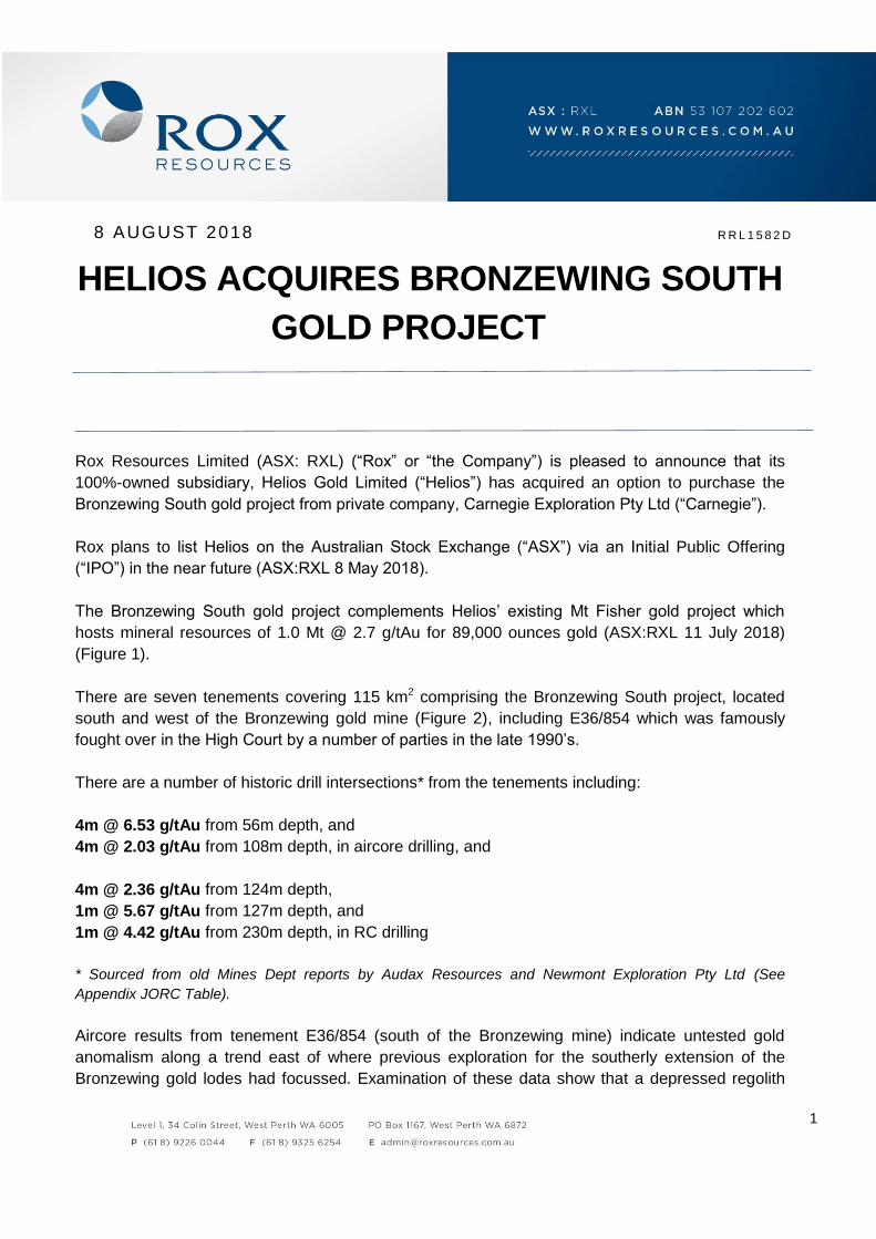
The Bronzewing South gold project complements Helios’ existing Mt Fisher gold project which
hosts mineral resources of 1.0 Mt @ 2.7 g/tAu for 89,000 ounces gold (ASX:RXL 11 July 2018)
(Figure 1).
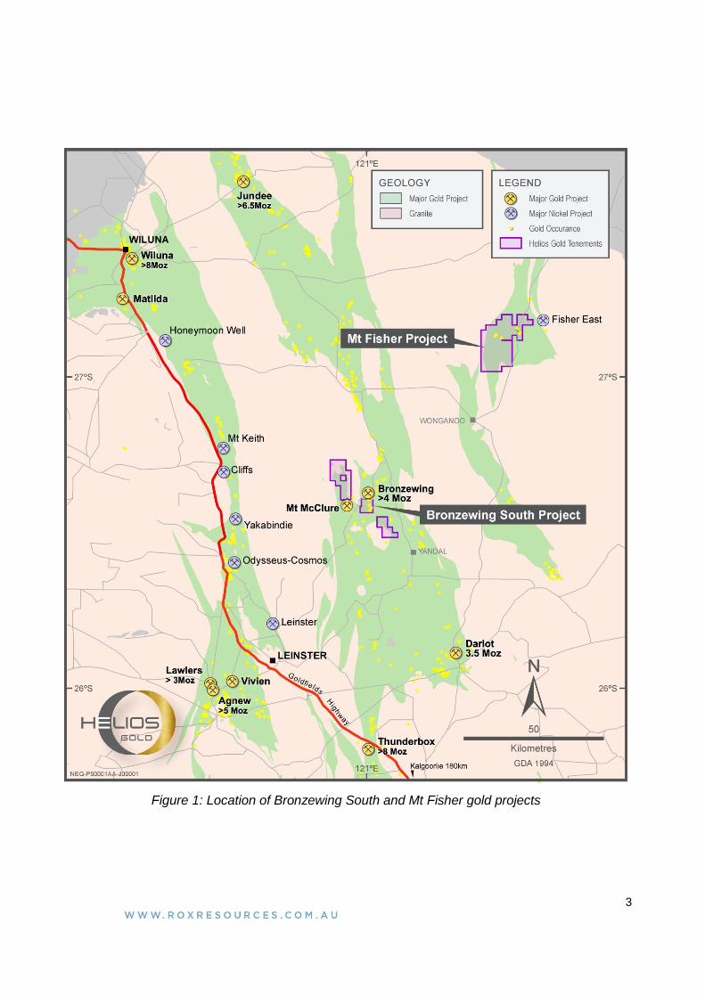
There are seven tenements covering 115 km2 comprising the Bronzewing South project, located
south and west of the Bronzewing gold mine (Figure 2), including E36/854 which was famously
fought over in the High Court by a number of parties in the late 1990’s.
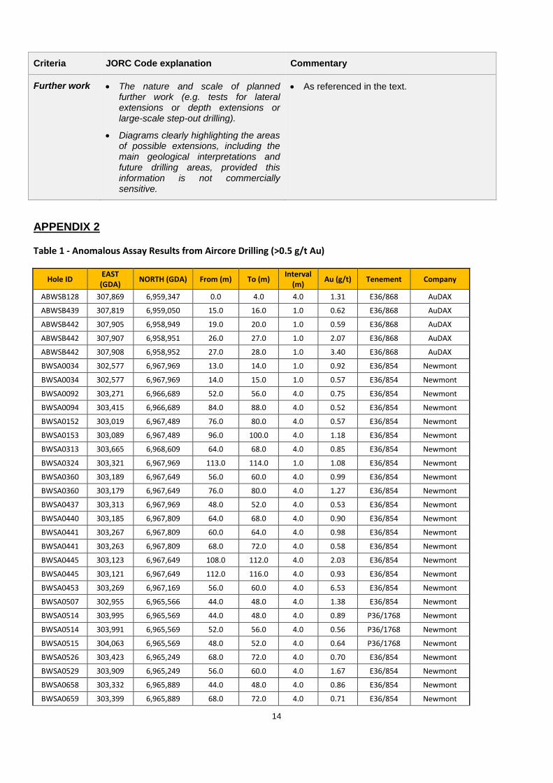
There are a number of historic drill intersections* from the tenements including:
4m @ 6.53 g/tAu from 56m depth, and
4m @ 2.03 g/tAu from 108m depth, in aircore drilling, and
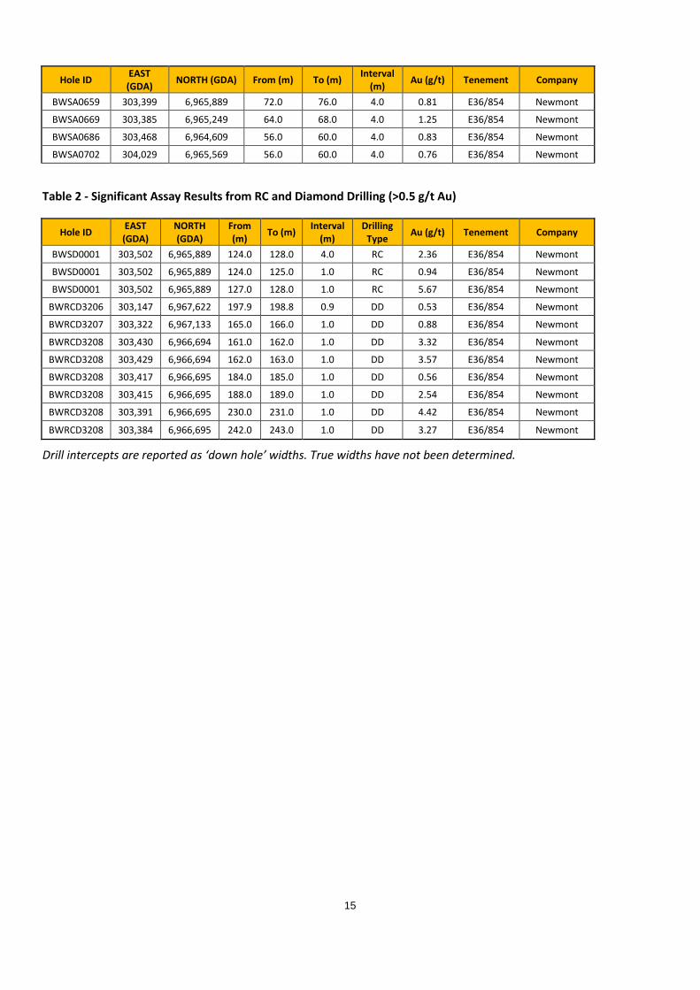
4m @ 2.36 g/tAu from 124m depth,
1m @ 5.67 g/tAu from 127m depth, and
1m @ 4.42 g/tAu from 230m depth, in RC drilling
* Sourced from old Mines Dept reports by Audax Resources and Newmont Exploration Pty Ltd (See
Appendix JORC Table).
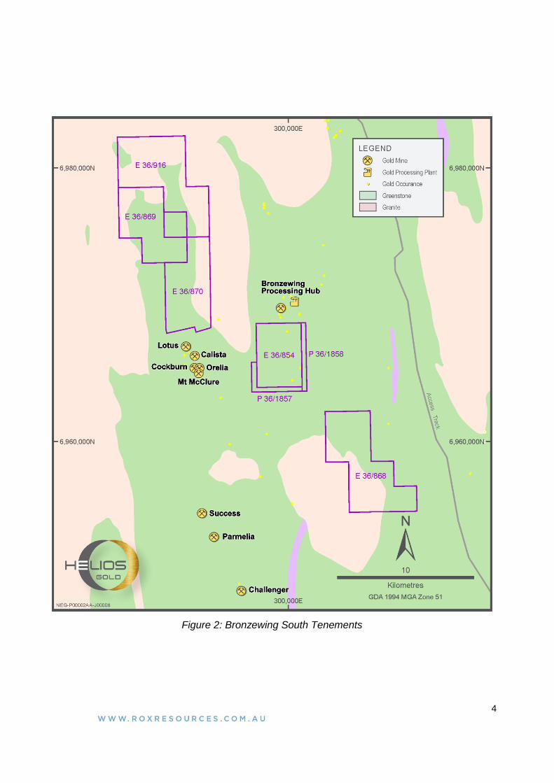
Aircore results from tenement E36/854 (south of the Bronzewing mine) indicate untested gold
anomalism along a trend east of where previous exploration for the southerly extension of the
Bronzewing gold lodes had focussed. Examination of these data show that a depressed regolith
8 AUGUST 2018 R R L 1 5 8 2 D

2
profile exists here (Figure 3), similar to that originally found in early drilling over the 3.6 million
ounce Bronzewing orebody.
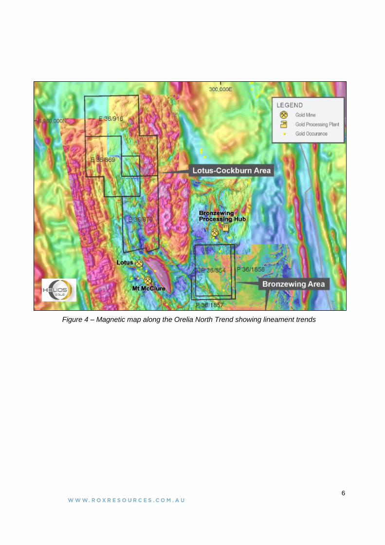
The tenements north west of Bronzewing (called the Orelia North trend) are along strike from the
Orelia gold deposit recently announced to contain > 1 million ounces of gold (ASX:EAR 14 June
2018), and extension of the shear hosting Orelia has been interpreted to continue into the Helios
tenements (Figure 4).
Helios plans to aggressively explore these tenements (and the Mt Fisher tenure) upon a successful
IPO and ASX listing.
Commercial Terms
The commercial terms of the option agreement are:
1. Payment of a non-refundable deposit of $20,000 cash up signing of the agreement for a
six- month option period,
2. Payment of $80,000 cash and the issue of 2,000,000 shares in Helios to Carnegie upon the
successful IPO and ASX listing of Helios (at this point the option will have been exercised),
3. A further issue of $725,000 in cash or Helios shares when an Inferred Mineral Resource of
greater than 250,000 ounces of gold is announced by Helios, and
4. $1,250,000 in cash or Helios shares when an Indicated Mineral Resource of greater than
500,000 ounces of gold is announced by Helios.
ENDS
For more information:
Shareholders/Investors Media
Ian Mulholland Michael Weir / Cameron Gilenko
Managing Director Citadel-MAGNUS
Tel: +61 8 9226 0044 Tel: +61 8 6160 4903
3
Figure 1: Location of Bronzewing South and Mt Fisher gold projects
4
Figure 2: Bronzewing South Tenements
5
Figure 3 - E36/854 - Contour of Depth to Drill Refusal
6
Figure 4 – Magnetic map along the Orelia North Trend showing lineament trends
7
Competent Person Statements:
Resource Statements
The information in this report that relates to gold Mineral Resources for the Mt Fisher project was reported to the ASX on 11 July 2018
(JORC 2012). Rox confirms that it is not aware of any new information or data that materially affects the information included in the
announcement of 11 July 2018, and that all material assumptions and technical parameters underpinning the estimates in the
announcement of 11 July 2018 continue to apply and have not materially changed.
The information in this report that relates to nickel Mineral Resources for the Fisher East project was reported to the ASX on 5 February
2016 (JORC 2012). Rox confirms that it is not aware of any new information or data that materially affects the information included in
the announcement of 5 February 2016, and that all material assumptions and technical parameters underpinning the estimates in the
announcement of 5 February 2016 continue to apply and have not materially changed.
The information in this report that relates to nickel Mineral Resources for the Collurabbie project was reported to the ASX on 18 August
2017 (JORC 2012). Rox confirms that it is not aware of any new information or data that materially affects the information included in
the announcement of 18 August 2017, and that all material assumptions and technical parameters underpinning the estimates in the
announcement of 18 August 2017 continue to apply and have not materially changed.
Exploration Results
The information in this report that relates to previous Exploration Results, was either prepared and first disclosed under the JORC Code
2004 or under the JORC Code 2012 and has been properly and extensively cross-referenced in the text to the date of original
announcement to ASX. In the case of the 2004 JORC Code Exploration Results and Mineral Resources, they have not been updated to
comply with the JORC Code 2012 on the basis that the information has not materially changed since it was last reported.
8
About Rox Resources
Rox Resources Limited is an emerging Australian minerals exploration company. The company has a number of key assets at
various levels of development with exposure to gold, nickel, copper and platinum group elements (PGE’s), including the Mt
Fisher Gold Project (WA), the Fisher East Nickel Project (WA), and the Collurabbie Nickel-Copper-PGE Project (WA).
Fisher East Nickel Project (100%)
The Fisher East nickel project is located in the North Eastern Goldfields region of Western Australia and hosts several nickel
sulphide deposits. The total project area is ~350km2.
Discovery of, and drilling at the Camelwood, Cannonball and Musket nickel prospects has defined a JORC 2012 Mineral
Resource (ASX:RXL 5 February 2016) of 2.0Mt grading 2.5% Ni reported at 1.5% Ni cut-off (Indicated Mineral Resource: 1.9Mt
grading 2.5% Ni, Inferred Mineral Resource: 0.1Mt grading 2.3% Ni) comprising massive and disseminated nickel sulphide
mineralisation, and containing 50,600 tonnes of nickel. Higher grade mineralisation is present in all deposits (refer to ASX
announcement above) and is still open at depth beneath each deposit. Additional nickel sulphide deposits continue to be
discovered (e.g. Sabre) and these will add to the resource base. Exploration is continuing to define further zones of potential
nickel sulphide mineralisation.
Mt Fisher Gold Project (100%)
The Mt Fisher gold project is located in the North Eastern Goldfields region of Western Australia, adjacent to the Fisher East
nickel project, and hosts several gold deposits. The total project area is ~220km2.
Drilling by Rox has also defined numerous high-grade gold targets and a JORC 2012 Measured, Indicated and Inferred Mineral
Resource (ASX:RXL 11 July 2018) of 1.0 million tonnes grading 2.7 g/t Au reported at a 0.8 g/tAu cut-off exists for 89,000
ounces of gold (Measured: 170,000 tonnes grading 4.1 g/t Au, Indicated: 220,000 tonnes grading 2.7 g/t Au, Inferred: 630,000
tonnes grading 2.3 g/t Au) aggregated over the Damsel, Moray Reef and Mt Fisher deposits.
Collurabbie Gold-Nickel Project (100%)
The Collurabbie project is located in the highly prospective North Eastern Goldfields region of Western Australia and is
prospective for gold and nickel. The project area of 123km2 hosts the Olympia nickel sulphide deposit and a number of other
prospects for nickel sulphide mineralisation. A JORC 2012 Inferred Mineral Resource of 573,000t grading 1.63% Ni, 1.19% Cu,
0.082% Co, 1.49g/t Pd, 0.85g/t Pt has been defined at Olympia (ASX:RXL 18 August 2017). The style of nickel sulphide
mineralisation is different to that at Fisher East, with a significant copper and PGE component at Collurabbie, and has been
compared to the Raglan nickel deposits in Canada (>1Mt contained nickel).
In addition, there is potential for gold mineralisation, with several strong drilling intersections including 2m @ 2.4g/t Au from the
Naxos prospect.
Bonya Copper Project (40%)
Rox (40%) has agreeed to sell its interest in the Bonya project to Thor Mining PLC for A$550,000 in Thor shares (29 March
2018). Completion is expected during the next quarter.
9
APPENDIX 1
JORC Code, 2012 Edition - Table 1
Section 1 Sampling Techniques and Data
Criteria JORC Code explanation Commentary
Sampling techniques
Nature and quality of sampling (e.g. cut channels, random chips, or specific specialised industry standard measurement tools appropriate to the minerals under investigation, such as down hole gamma sondes, or handheld XRF instruments, etc). These examples should not be taken as limiting the broad meaning of sampling.
Include reference to measures taken to ensure sample representivity and the appropriate calibration of any measurement tools or systems used.
Aspects of the determination of mineralisation that are Material to the Public Report.
In cases where ‘industry standard’ work has been done this would be relatively simple (e.g. ‘reverse circulation drilling was used to obtain 1 m samples from which 3 kg was pulverised to produce a 30 g charge for fire assay’). In other cases more explanation may be required, such as where there is coarse gold that has inherent sampling problems. Unusual commodities or mineralisation types (e.g. submarine nodules) may warrant disclosure of detailed information.
Aircore, RAB Drilling
Aircore samples were collected as 4m composited intervals, it is unknown if these were spear or split sampled and results are taken as being indicative only.
RC Drilling
Single metre intervals were collected and composited into 4m intervals for first pass assay. Samples identified as anomalous were resubmitted as single metre intervals. Samples are assumed to have been split through a cyclone to produce a composite and single metre sample but it is unknown if this was done through a cone or riffle splitter.
Diamond Drilling
RC pre-collar with HQ3 diamond tail and was undertaken
Drilling techniques
Drill type (e.g. core, reverse circulation, open-hole hammer, rotary air blast, auger, Bangka, sonic, etc) and details (e.g. core diameter, triple or standard tube, depth of diamond tails, face-sampling bit or other type, whether core is oriented and if so, by what method, etc).
Newmont drilled 707 AC holes for 50,260m and 45 RAB holes for 1745m. AuDAX drilled 555 RAB/AC holes for 30,618m during the same period.
Drill sample recovery
Method of recording and assessing core and chip sample recoveries and results assessed.
Measures taken to maximise sample recovery and ensure representative nature of the samples.
Whether a relationship exists between sample recovery and grade and whether sample bias may have
Not documented in historic reporting.
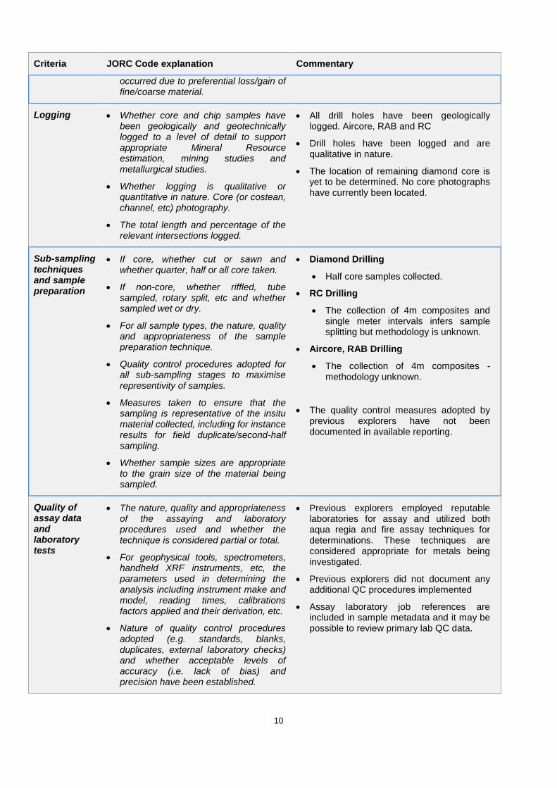
10
Criteria JORC Code explanation Commentary
occurred due to preferential loss/gain of fine/coarse material.
Logging Whether core and chip samples have been geologically and geotechnically logged to a level of detail to support appropriate Mineral Resource estimation, mining studies and metallurgical studies.
Whether logging is qualitative or quantitative in nature. Core (or costean, channel, etc) photography.
The total length and percentage of the relevant intersections logged.
All drill holes have been geologically logged. Aircore, RAB and RC
Drill holes have been logged and are qualitative in nature.
The location of remaining diamond core is yet to be determined. No core photographs have currently been located.
Sub-sampling techniques and sample preparation
If core, whether cut or sawn and whether quarter, half or all core taken.
If non-core, whether riffled, tube sampled, rotary split, etc and whether sampled wet or dry.
For all sample types, the nature, quality and appropriateness of the sample preparation technique.
Quality control procedures adopted for all sub-sampling stages to maximise representivity of samples.
Measures taken to ensure that the sampling is representative of the insitu material collected, including for instance results for field duplicate/second-half sampling.
Whether sample sizes are appropriate to the grain size of the material being sampled.
Diamond Drilling
Half core samples collected.
RC Drilling
The collection of 4m composites and single meter intervals infers sample splitting but methodology is unknown.
Aircore, RAB Drilling
The collection of 4m composites - methodology unknown.
The quality control measures adopted by previous explorers have not been documented in available reporting.
Quality of assay data and laboratory tests
The nature, quality and appropriateness of the assaying and laboratory procedures used and whether the technique is considered partial or total.
For geophysical tools, spectrometers, handheld XRF instruments, etc, the parameters used in determining the analysis including instrument make and model, reading times, calibrations factors applied and their derivation, etc.
Nature of quality control procedures adopted (e.g. standards, blanks, duplicates, external laboratory checks) and whether acceptable levels of accuracy (i.e. lack of bias) and precision have been established.
Previous explorers employed reputable laboratories for assay and utilized both aqua regia and fire assay techniques for determinations. These techniques are considered appropriate for metals being investigated.
Previous explorers did not document any additional QC procedures implemented
Assay laboratory job references are included in sample metadata and it may be possible to review primary lab QC data.
11
Criteria JORC Code explanation Commentary
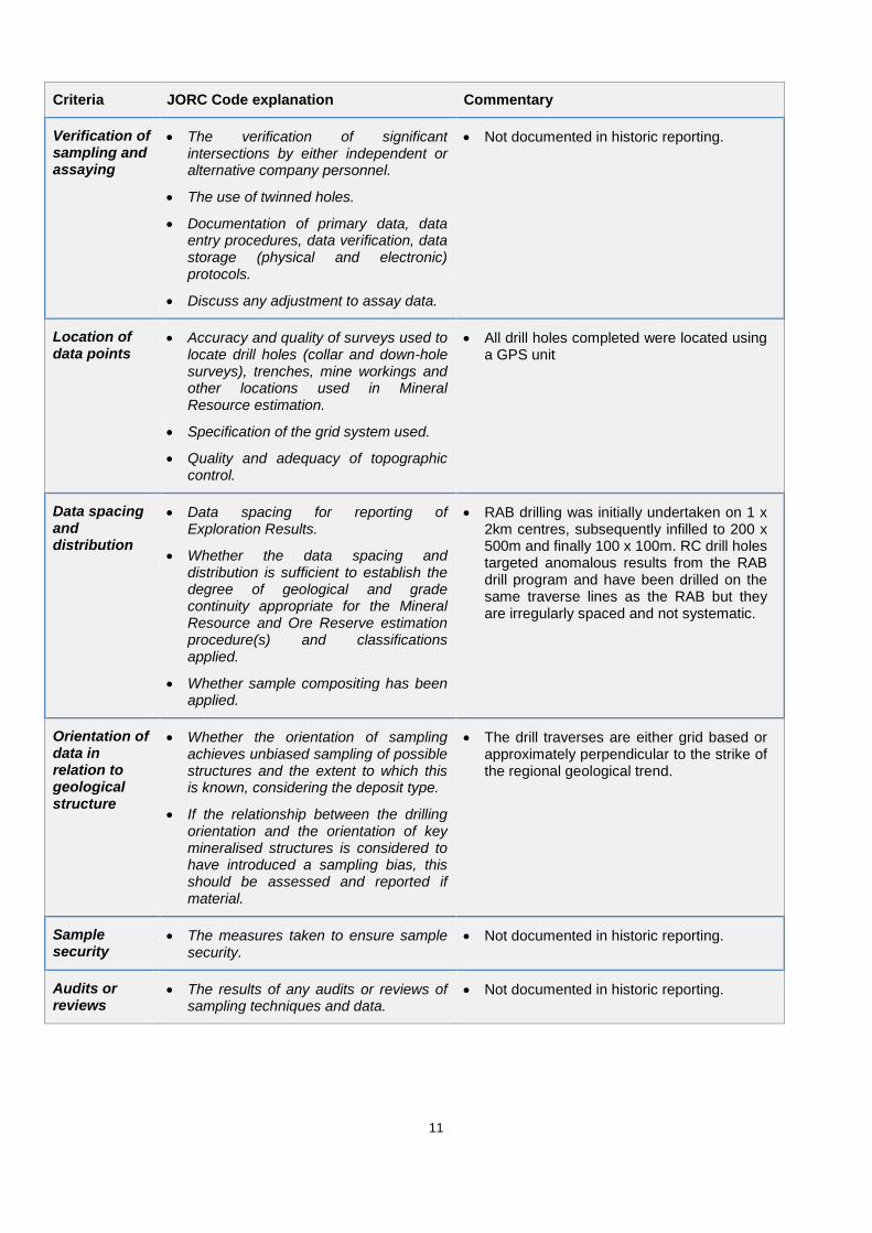
Verification of sampling and assaying
The verification of significant intersections by either independent or alternative company personnel.
The use of twinned holes.
Documentation of primary data, data entry procedures, data verification, data storage (physical and electronic) protocols.
Discuss any adjustment to assay data.
Not documented in historic reporting.
Location of data points
Accuracy and quality of surveys used to locate drill holes (collar and down-hole surveys), trenches, mine workings and other locations used in Mineral Resource estimation.
Specification of the grid system used.
Quality and adequacy of topographic control.
All drill holes completed were located using a GPS unit
Data spacing and distribution
Data spacing for reporting of Exploration Results.
Whether the data spacing and distribution is sufficient to establish the degree of geological and grade continuity appropriate for the Mineral Resource and Ore Reserve estimation procedure(s) and classifications applied.
Whether sample compositing has been applied.
RAB drilling was initially undertaken on 1 x 2km centres, subsequently infilled to 200 x 500m and finally 100 x 100m. RC drill holes targeted anomalous results from the RAB drill program and have been drilled on the same traverse lines as the RAB but they are irregularly spaced and not systematic.
Orientation of data in relation to geological structure
Whether the orientation of sampling achieves unbiased sampling of possible structures and the extent to which this is known, considering the deposit type.
If the relationship between the drilling orientation and the orientation of key mineralised structures is considered to have introduced a sampling bias, this should be assessed and reported if material.
The drill traverses are either grid based or approximately perpendicular to the strike of the regional geological trend.
Sample security
The measures taken to ensure sample security.
Not documented in historic reporting.
Audits or reviews
The results of any audits or reviews of sampling techniques and data.
Not documented in historic reporting.
12
Section 2 Reporting of Exploration Results
(Criteria listed in the preceding section also apply to this section.)
Criteria JORC Code explanation Commentary
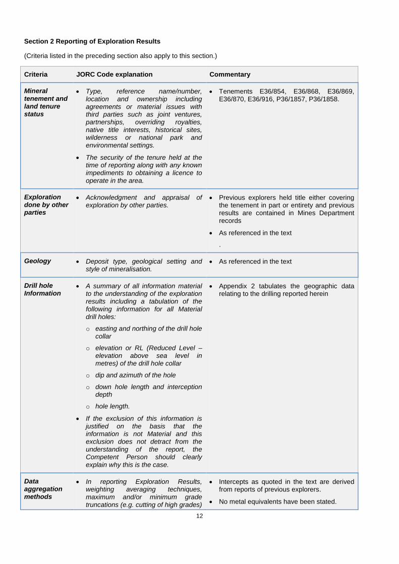
Mineral tenement and land tenure status
Type, reference name/number, location and ownership including agreements or material issues with third parties such as joint ventures, partnerships, overriding royalties, native title interests, historical sites, wilderness or national park and environmental settings.
The security of the tenure held at the time of reporting along with any known impediments to obtaining a licence to operate in the area.
Tenements E36/854, E36/868, E36/869, E36/870, E36/916, P36/1857, P36/1858.
Exploration done by other parties
Acknowledgment and appraisal of exploration by other parties.
Previous explorers held title either covering the tenement in part or entirety and previous results are contained in Mines Department records
As referenced in the text
.
Geology Deposit type, geological setting and style of mineralisation.
As referenced in the text
Drill hole Information
A summary of all information material to the understanding of the exploration results including a tabulation of the following information for all Material drill holes:
o easting and northing of the drill hole collar
o elevation or RL (Reduced Level – elevation above sea level in metres) of the drill hole collar
o dip and azimuth of the hole
o down hole length and interception depth
o hole length.
If the exclusion of this information is justified on the basis that the information is not Material and this exclusion does not detract from the understanding of the report, the Competent Person should clearly explain why this is the case.
Appendix 2 tabulates the geographic data relating to the drilling reported herein
Data aggregation methods
In reporting Exploration Results, weighting averaging techniques, maximum and/or minimum grade truncations (e.g. cutting of high grades)
Intercepts as quoted in the text are derived from reports of previous explorers.
No metal equivalents have been stated.
13
Criteria JORC Code explanation Commentary
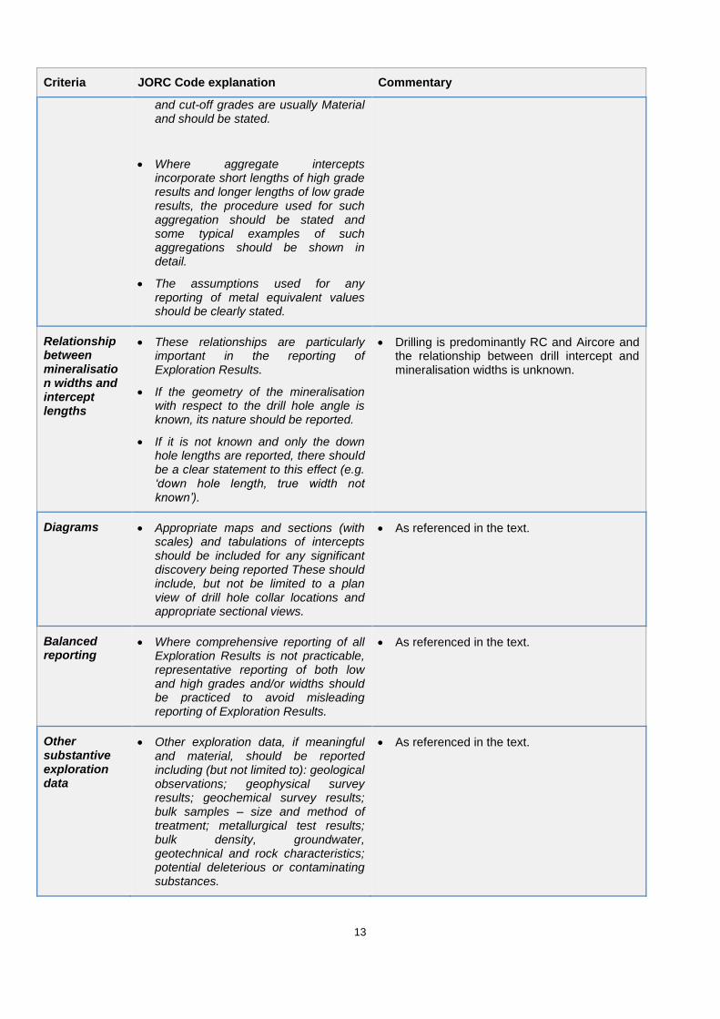
and cut-off grades are usually Material and should be stated.
Where aggregate intercepts incorporate short lengths of high grade results and longer lengths of low grade results, the procedure used for such aggregation should be stated and some typical examples of such aggregations should be shown in detail.
The assumptions used for any reporting of metal equivalent values should be clearly stated.
Relationship between mineralisation widths and intercept lengths
These relationships are particularly important in the reporting of Exploration Results.
If the geometry of the mineralisation with respect to the drill hole angle is known, its nature should be reported.
If it is not known and only the down hole lengths are reported, there should be a clear statement to this effect (e.g. ‘down hole length, true width not known’).
Drilling is predominantly RC and Aircore and the relationship between drill intercept and mineralisation widths is unknown.
Diagrams Appropriate maps and sections (with scales) and tabulations of intercepts should be included for any significant discovery being reported These should include, but not be limited to a plan view of drill hole collar locations and appropriate sectional views.
As referenced in the text.
Balanced reporting
Where comprehensive reporting of all Exploration Results is not practicable, representative reporting of both low and high grades and/or widths should be practiced to avoid misleading reporting of Exploration Results.
As referenced in the text.
Other substantive exploration data
Other exploration data, if meaningful and material, should be reported including (but not limited to): geological observations; geophysical survey results; geochemical survey results; bulk samples – size and method of treatment; metallurgical test results; bulk density, groundwater, geotechnical and rock characteristics; potential deleterious or contaminating substances.
As referenced in the text.
14
Criteria JORC Code explanation Commentary
Further work The nature and scale of planned further work (e.g. tests for lateral extensions or depth extensions or large-scale step-out drilling).
Diagrams clearly highlighting the areas of possible extensions, including the main geological interpretations and future drilling areas, provided this information is not commercially sensitive.
As referenced in the text.
APPENDIX 2
Table 1 - Anomalous Assay Results from Aircore Drilling (>0.5 g/t Au)
Hole ID EAST (GDA)
NORTH (GDA) From (m) To (m) Interval
(m) Au (g/t) Tenement Company
ABWSB128 307,869 6,959,347 0.0 4.0 4.0 1.31 E36/868 AuDAX
ABWSB439 307,819 6,959,050 15.0 16.0 1.0 0.62 E36/868 AuDAX
ABWSB442 307,905 6,958,949 19.0 20.0 1.0 0.59 E36/868 AuDAX
ABWSB442 307,907 6,958,951 26.0 27.0 1.0 2.07 E36/868 AuDAX
ABWSB442 307,908 6,958,952 27.0 28.0 1.0 3.40 E36/868 AuDAX
BWSA0034 302,577 6,967,969 13.0 14.0 1.0 0.92 E36/854 Newmont
BWSA0034 302,577 6,967,969 14.0 15.0 1.0 0.57 E36/854 Newmont
BWSA0092 303,271 6,966,689 52.0 56.0 4.0 0.75 E36/854 Newmont
BWSA0094 303,415 6,966,689 84.0 88.0 4.0 0.52 E36/854 Newmont
BWSA0152 303,019 6,967,489 76.0 80.0 4.0 0.57 E36/854 Newmont
BWSA0153 303,089 6,967,489 96.0 100.0 4.0 1.18 E36/854 Newmont
BWSA0313 303,665 6,968,609 64.0 68.0 4.0 0.85 E36/854 Newmont
BWSA0324 303,321 6,967,969 113.0 114.0 1.0 1.08 E36/854 Newmont
BWSA0360 303,189 6,967,649 56.0 60.0 4.0 0.99 E36/854 Newmont
BWSA0360 303,179 6,967,649 76.0 80.0 4.0 1.27 E36/854 Newmont
BWSA0437 303,313 6,967,969 48.0 52.0 4.0 0.53 E36/854 Newmont
BWSA0440 303,185 6,967,809 64.0 68.0 4.0 0.90 E36/854 Newmont
BWSA0441 303,267 6,967,809 60.0 64.0 4.0 0.98 E36/854 Newmont
BWSA0441 303,263 6,967,809 68.0 72.0 4.0 0.58 E36/854 Newmont
BWSA0445 303,123 6,967,649 108.0 112.0 4.0 2.03 E36/854 Newmont
BWSA0445 303,121 6,967,649 112.0 116.0 4.0 0.93 E36/854 Newmont
BWSA0453 303,269 6,967,169 56.0 60.0 4.0 6.53 E36/854 Newmont
BWSA0507 302,955 6,965,566 44.0 48.0 4.0 1.38 E36/854 Newmont
BWSA0514 303,995 6,965,569 44.0 48.0 4.0 0.89 P36/1768 Newmont
BWSA0514 303,991 6,965,569 52.0 56.0 4.0 0.56 P36/1768 Newmont
BWSA0515 304,063 6,965,569 48.0 52.0 4.0 0.64 P36/1768 Newmont
BWSA0526 303,423 6,965,249 68.0 72.0 4.0 0.70 E36/854 Newmont
BWSA0529 303,909 6,965,249 56.0 60.0 4.0 1.67 E36/854 Newmont
BWSA0658 303,332 6,965,889 44.0 48.0 4.0 0.86 E36/854 Newmont
BWSA0659 303,399 6,965,889 68.0 72.0 4.0 0.71 E36/854 Newmont
15
Hole ID EAST (GDA)
NORTH (GDA) From (m) To (m) Interval
(m) Au (g/t) Tenement Company
BWSA0659 303,399 6,965,889 72.0 76.0 4.0 0.81 E36/854 Newmont
BWSA0669 303,385 6,965,249 64.0 68.0 4.0 1.25 E36/854 Newmont
BWSA0686 303,468 6,964,609 56.0 60.0 4.0 0.83 E36/854 Newmont
BWSA0702 304,029 6,965,569 56.0 60.0 4.0 0.76 E36/854 Newmont
Table 2 - Significant Assay Results from RC and Diamond Drilling (>0.5 g/t Au)
Hole ID EAST (GDA)
NORTH (GDA)
From (m)
To (m) Interval
(m) Drilling
Type Au (g/t) Tenement Company
BWSD0001 303,502 6,965,889 124.0 128.0 4.0 RC 2.36 E36/854 Newmont
BWSD0001 303,502 6,965,889 124.0 125.0 1.0 RC 0.94 E36/854 Newmont
BWSD0001 303,502 6,965,889 127.0 128.0 1.0 RC 5.67 E36/854 Newmont
BWRCD3206 303,147 6,967,622 197.9 198.8 0.9 DD 0.53 E36/854 Newmont
BWRCD3207 303,322 6,967,133 165.0 166.0 1.0 DD 0.88 E36/854 Newmont
BWRCD3208 303,430 6,966,694 161.0 162.0 1.0 DD 3.32 E36/854 Newmont
BWRCD3208 303,429 6,966,694 162.0 163.0 1.0 DD 3.57 E36/854 Newmont
BWRCD3208 303,417 6,966,695 184.0 185.0 1.0 DD 0.56 E36/854 Newmont
BWRCD3208 303,415 6,966,695 188.0 189.0 1.0 DD 2.54 E36/854 Newmont
BWRCD3208 303,391 6,966,695 230.0 231.0 1.0 DD 4.42 E36/854 Newmont
BWRCD3208 303,384 6,966,695 242.0 243.0 1.0 DD 3.27 E36/854 Newmont
Drill intercepts are reported as ‘down hole’ widths. True widths have not been determined.