Embed Size (px)
Citation preview
Heikki Salmirinne
Geological Survey of Finland, Rovaniemi
Unmanned Aerial Vehicles in Mineral Exploration and Mining Operations in the Arctic Areas of Finland
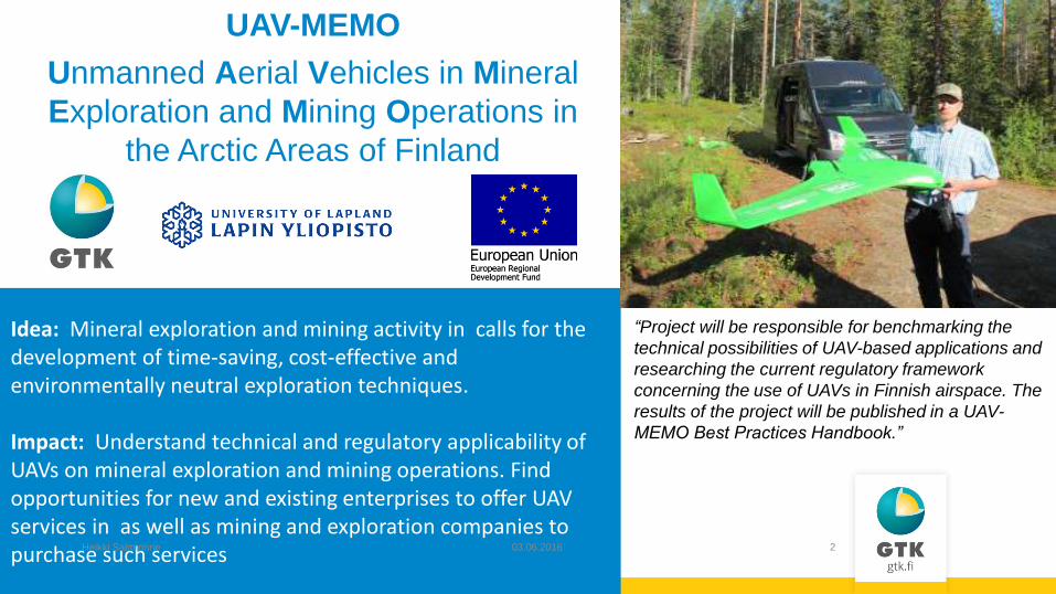
Idea: Mineral exploration and mining activity in calls for the development of time-saving, cost-effective and environmentally neutral exploration techniques. Impact: Understand technical and regulatory applicability of UAVs on mineral exploration and mining operations. Find opportunities for new and existing enterprises to offer UAV services in as well as mining and exploration companies to purchase such services 03.06.2016 Heikki Salmirinne 2
“Project will be responsible for benchmarking the
technical possibilities of UAV-based applications and
researching the current regulatory framework
concerning the use of UAVs in Finnish airspace. The
results of the project will be published in a UAV-
MEMO Best Practices Handbook.”
UAV-MEMO
Unmanned Aerial Vehicles in Mineral
Exploration and Mining Operations in
the Arctic Areas of Finland
03.06.2016 Heikki Salmirinne 3
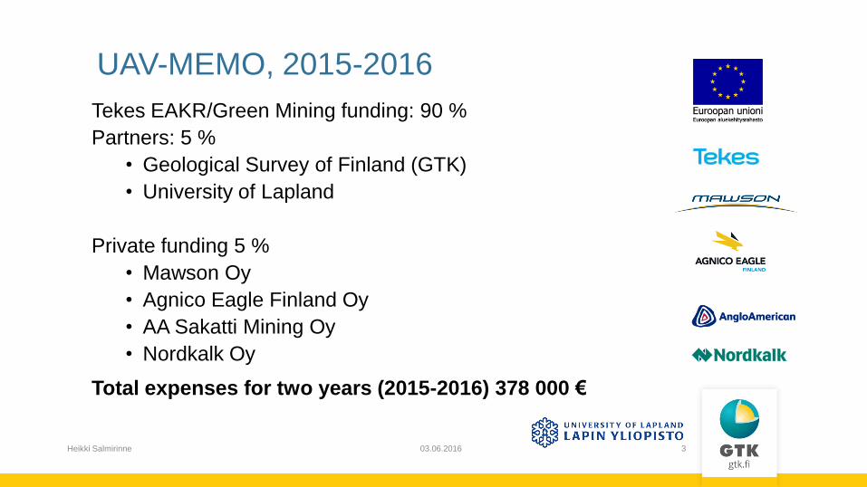
UAV-MEMO, 2015-2016
Tekes EAKR/Green Mining funding: 90 %
Partners: 5 %
• Geological Survey of Finland (GTK)
• University of Lapland
Private funding 5 %
• Mawson Oy
• Agnico Eagle Finland Oy
• AA Sakatti Mining Oy
• Nordkalk Oy
Total expenses for two years (2015-2016) 378 000 €
03.06.2016 Heikki Salmirinne 4
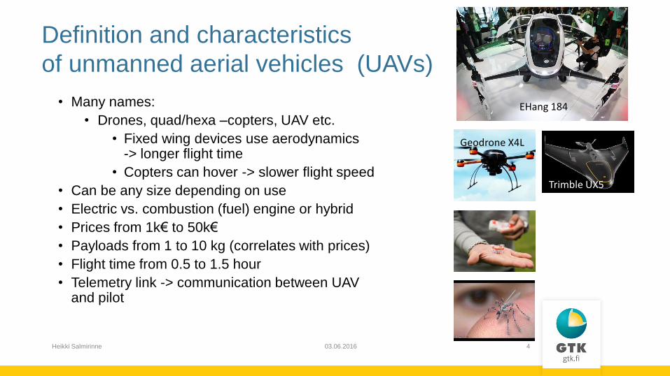
Trimble UX5
Geodrone X4L
Definition and characteristics
of unmanned aerial vehicles (UAVs)
• Many names:
• Drones, quad/hexa –copters, UAV etc.
• Fixed wing devices use aerodynamics -> longer flight time
• Copters can hover -> slower flight speed
• Can be any size depending on use
• Electric vs. combustion (fuel) engine or hybrid
• Prices from 1k€ to 50k€
• Payloads from 1 to 10 kg (correlates with prices)
• Flight time from 0.5 to 1.5 hour
• Telemetry link -> communication between UAV and pilot
EHang 184

03.06.2016 Heikki Salmirinne 5
• Magnetic -> mineral exploration
• Electromagnetic (under development) -> mineral exploration
• Gamma radiation -> mineral exploration
• Aerial photography -> volumes, geological mapping
• Lidar -> volumes of rock piles or tailings ponds, geological mapping,
geomorphological studies
• Infrared / Thermal photography -> environmental studies, monitoring tailings
• Hyperspectral imaging
-> environmental studies, geological mapping
• Etc.
Possible suitable UAV survey
techniques and applications for
mineral exploration or mining:
03.06.2016 Heikki Salmirinne 6
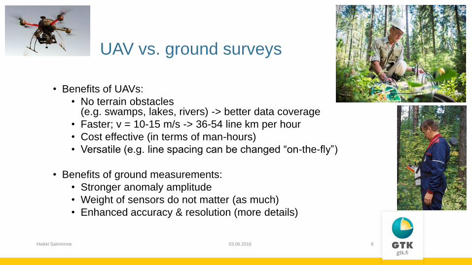
• Benefits of UAVs:
• No terrain obstacles (e.g. swamps, lakes, rivers) -> better data coverage
• Faster; v = 10-15 m/s -> 36-54 line km per hour
• Cost effective (in terms of man-hours)
• Versatile (e.g. line spacing can be changed “on-the-fly”)
• Benefits of ground measurements:
• Stronger anomaly amplitude
• Weight of sensors do not matter (as much)
• Enhanced accuracy & resolution (more details)
UAV vs. ground surveys
03.06.2016 Heikki Salmirinne 7
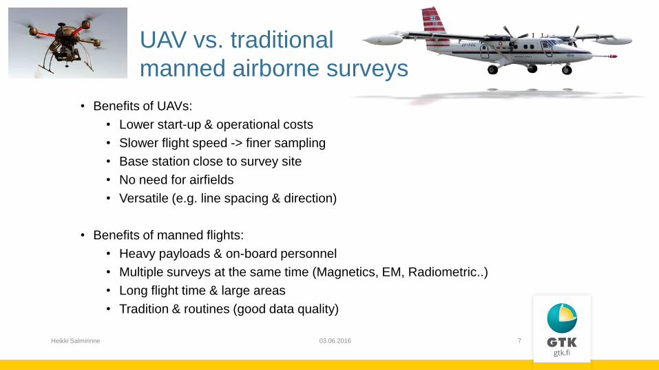
UAV vs. traditional
manned airborne surveys
• Benefits of UAVs:
• Lower start-up & operational costs
• Slower flight speed -> finer sampling
• Base station close to survey site
• No need for airfields
• Versatile (e.g. line spacing & direction)
• Benefits of manned flights:
• Heavy payloads & on-board personnel
• Multiple surveys at the same time (Magnetics, EM, Radiometric..)
• Long flight time & large areas
• Tradition & routines (good data quality)
03.06.2016 Heikki Salmirinne 8
Disadvantages of UAV
1. Light payloads
e.g. gravity systems are far too heavy
EM systems are too large and have high power requirements
radiometric systems have reduced in size where they are nearing the point of being
sufficiently small for UAV use
2. UAV’s are small and produce high levels of electrical noise
noisy platform for geophysical methods
3. UAV’s are light and tend to be disturbed by wind and air turbulence
presents problems with all forms of data
Development of sensors and careful design of survey systems is important!
03.06.2016 Heikki Salmirinne 9
• Legislation different from country to country
• Legislation in Finland; new aviation regulation on the use of remotely piloted unmanned aircraft and model aircraft came into force in october 2015 (OPS M1-32)
• Limitations for UAVs (in Finland):
• Weight < 25 kg, altitude <150 m, distance <500 m
• Operation modes:
• VLOS – Visual Line of Sight (always visible)
• EVLOS – Extended VLOS (co-pilots see)
• BVLOS – Beyond VLOS (airspace need to be closed!)
• Best option is to reserve the airspace temporarily and use BVLOS operation
Aviation regulations in Finland (TRAFI)
03.06.2016 Heikki Salmirinne 10
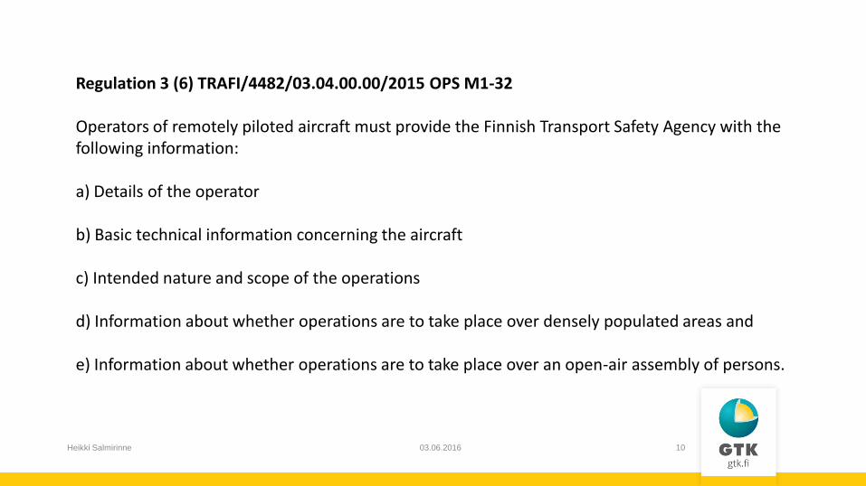
Regulation 3 (6) TRAFI/4482/03.04.00.00/2015 OPS M1-32 Operators of remotely piloted aircraft must provide the Finnish Transport Safety Agency with the following information: a) Details of the operator b) Basic technical information concerning the aircraft c) Intended nature and scope of the operations d) Information about whether operations are to take place over densely populated areas and e) Information about whether operations are to take place over an open-air assembly of persons.
03.06.2016 Heikki Salmirinne 11
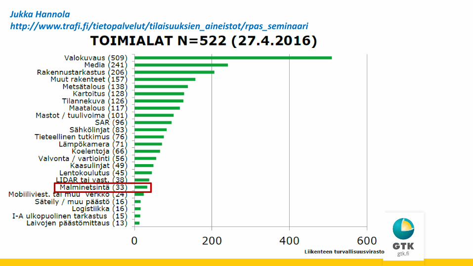
Jukka Hannola http://www.trafi.fi/tietopalvelut/tilaisuuksien_aineistot/rpas_seminaari
03.06.2016 Heikki Salmirinne 12
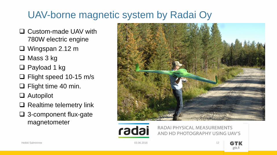
UAV-borne magnetic system by Radai Oy
Custom-made UAV with
780W electric engine
Wingspan 2.12 m
Mass 3 kg
Payload 1 kg
Flight speed 10-15 m/s
Flight time 40 min.
Autopilot
Realtime telemetry link
3-component flux-gate
magnetometer
03.06.2016 Heikki Salmirinne 13
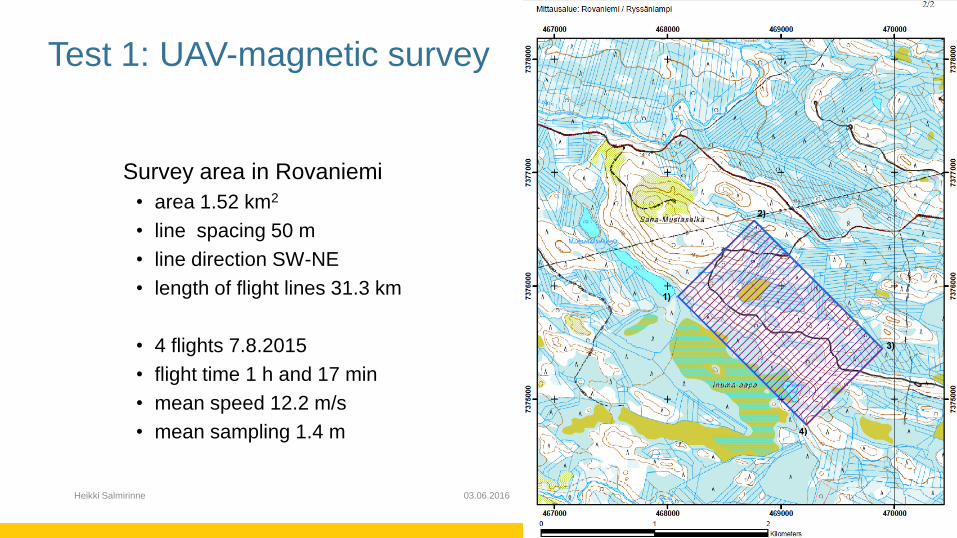
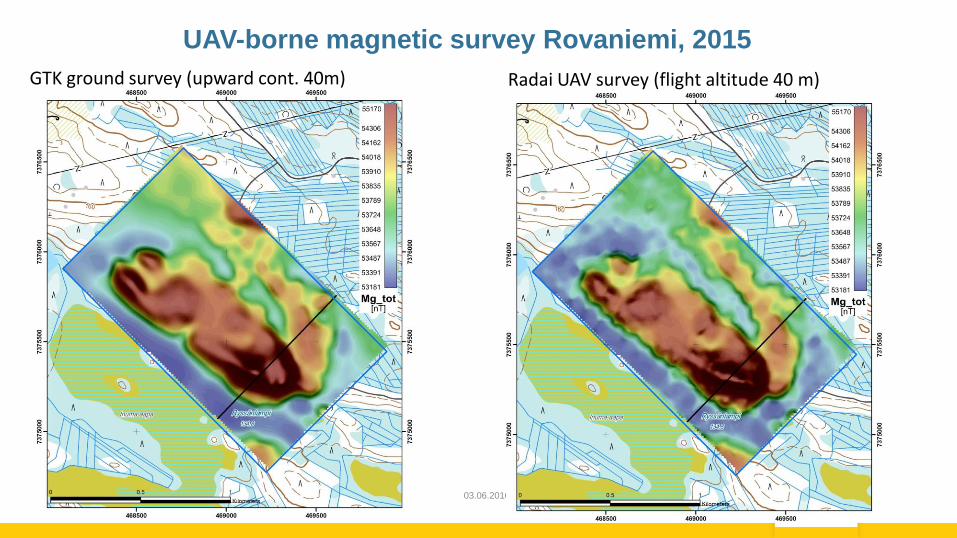
Test 1: UAV-magnetic survey
Survey area in Rovaniemi
• area 1.52 km2
• line spacing 50 m
• line direction SW-NE
• length of flight lines 31.3 km
• 4 flights 7.8.2015
• flight time 1 h and 17 min
• mean speed 12.2 m/s
• mean sampling 1.4 m
03.06.2016 Heikki Salmirinne 14
UAV-borne magnetic survey Rovaniemi, 2015
GTK ground survey (upward cont. 40m) Radai UAV survey (flight altitude 40 m)
03.06.2016 Heikki Salmirinne 15
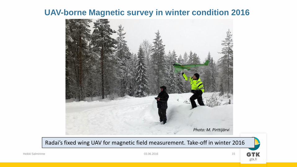
Radai’s fixed wing UAV for magnetic field measurement. Take-off in winter 2016
UAV-borne Magnetic survey in winter condition 2016
Photo: M. Pirttijärvi
03.06.2016 Heikki Salmirinne 16
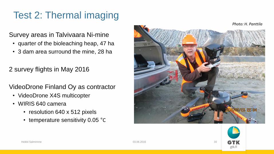
Survey areas in Talvivaara Ni-mine
• quarter of the bioleaching heap, 47 ha
• 3 dam area surround the mine, 28 ha
2 survey flights in May 2016
VideoDrone Finland Oy as contractor
• VideoDrone X4S multicopter
• WIRIS 640 camera
• resolution 640 x 512 pixels
• temperature sensitivity 0.05 °C
Test 2: Thermal imaging Photo: H. Panttila
03.06.2016 Heikki Salmirinne 17
Results of UAV-MEMO -project will be published in the beginning of 2017:
GTK: Tutkimusraportti / Report of Investigation
“UAV-MEMO handbook” Miehittämättömät ilma-alukset malminetsinnässä ja kaivostoiminnassa:
Menetelmät ja käytön sääntely Suomessa
Summary: Unmanned Aerial Vehicles in Mineral Exploration and Mining Operations:
Applicable Methods and Regulation in Finland
Authors:
Huttunen M., Karinen, T., Konnunaho, J., Kurimo, M., Middleton, M., Niiranen, T., Nykänen,
V., Panttila, H., Pirinen, H., Salmirinne, H. ja Turunen, P.,…
03.06.2016 Heikki Salmirinne 18
Thanks!