Embed Size (px)
Citation preview

Hartbeespoort Area Precinct Plan2014

Prepared by:
Riana du Plessis Urban Planning cc
for:
Madibeng Local Municipality
and
Department of Rural Development and Land Reform
Contributors:
Motla Consulting Engineers
Civilconsult Consulting Engineers
January 2014

Contents
2014Hartbeespoort Area Precinct Plan
i
Chapter 1: Introduction ........................................................................... 2
1.1 Background .....................................................................................................2
1.2 Purpose of the Precinct Plan ...........................................................................2
1.3 Project Objectives ...........................................................................................2
1.4 DefiningtheStudyArea ..................................................................................3
Chapter 2: Context ................................................................................... 6
2.1 AdministrativeContext ....................................................................................6
2.2 RegionalandLocalContext ............................................................................6
2.3 PolicyContext .................................................................................................6
2.3.1 MadibengSpatialDevelopmentFramework,2009 ..............................6
2.3.2 HartbeespoortDamStructurePlan,1997 ..........................................10
2.3.3 MadibengEnvironmentalManagementFramework,2009 ................10
2.3.4 Magaliesberg Environmental Management Framework andPlan,2007 ..........................................................................................16
2.3.5 Magaliesberg Biosphere ....................................................................16
2.3.6 MadibengIntegratedDevelopmentPlan,2013-2014 ......................19
2.3.7 RegionalSpatialDevelopmentFramework2013forRegion3:CityofTshwaneMetropolitanMunicipality .........................................20
2.3.8 LandUseSchemesinOperation .......................................................20
Contents
Chapter 3: Precinct Analysis ................................................................ 24
3.1 BiophysicalCharacteristics ...........................................................................24
3.1.1 Topography ........................................................................................24
3.1.2 GeologicalandSoilConditions ..........................................................26
3.1.3 HartbeespoortDam ...........................................................................26
3.1.4 EnvironmentalSensitivity ...................................................................28
3.2 CadastralCompositionofRuralEnvironment ...............................................30
3.3 SpatialFormandLandUses .........................................................................30
3.3.1 GeneralSpatialForm .........................................................................30
3.3.2 ResidentialDevelopment ...................................................................30
3.3.3 BusinessDevelopment ......................................................................34
3.3.4 TourismandRecreation .....................................................................34
3.3.5 SocialandCommunityServices ........................................................35
3.3.5.1Education,LibrariesandCommunityHalls.............................35
3.3.5.2 Recreation ..............................................................................35
3.3.5.3SafetyandSecurity ................................................................35
3.3.5.4 Health .....................................................................................35
3.3.5.5Cemeteries .............................................................................35
3.3.6 MovementNetwork ............................................................................36
3.3.6.1ExistingRoads........................................................................36
Contents
2014 Hartbeespoort Area Precinct Plan
ii
3.3.6.2 Planned Roads .......................................................................36
3.3.6.3 Rail .........................................................................................36
3.3.6.4RoadBasedPublicTransport .................................................37
3.3.6.5RoadSafety ............................................................................37
3.4 Infrastructure .................................................................................................37
3.4.1 Electricity ...........................................................................................37
3.4.2 WaterSupply .....................................................................................41
3.4.2.1WaterSupplytotheEastoftheHartbeespoortDam .............41
3.4.2.2WaterSupplytotheAreasNorthandNorthWestoftheHartbeespoortDam ................................................................41
3.4.2.3WaterSupply to theAreasSouthandSouthWestoftheHartbeespoortDam ..........................................................41
3.4.3 Sewer .................................................................................................41
3.4.3.1HandlingofSeweragetotheeastoftheHartbeespoortDam 41
3.4.3.2Handling of Sewerage to the areas north and northwestoftheHartbeespoortDam ..............................................41
3.4.3.3HandlingofSeweragetotheareassouthandsouthwestoftheHartbeespoortDam ..............................................42
3.5 Economy .......................................................................................................42
3.6 Socio-EconomicProfile .................................................................................42
3.7 CulturalHeritage ...........................................................................................46
Chapter 4: Issues ................................................................................... 48
4.1 SWOTAnalysis .............................................................................................48
4.1.1 StrengthsandOpportunities ..............................................................48
4.1.2 WeaknessesandThreats ..................................................................48
4.2 Issues ............................................................................................................49
Chapter 5: Precinct Plan ....................................................................... 54
5.1 DevelopmentObjectives ...............................................................................54
5.2 DevelopmentPrinciples ................................................................................54
5.3 SpatialDevelopmentConceptandStrategies ..............................................55
5.4 DevelopmentRestrictionZones ....................................................................59
5.5 GuidelinesforDevelopmentZones ...............................................................59
5.5.1 DevelopmentZone1 .........................................................................61
5.5.2 DevelopmentZone2 .........................................................................63
5.5.3 DevelopmentZone3 .........................................................................64
5.5.4 DevelopmentZone4 .........................................................................65
5.5.5 DevelopmentZone5 .........................................................................66
5.5.6 DevelopmentZone6 .........................................................................66
5.5.7 DevelopmentZone7 .........................................................................67
5.5.8 DevelopmentZone8 .........................................................................70
5.5.9 DevelopmentZone9 .........................................................................75

Contents
2014Hartbeespoort Area Precinct Plan
iii
Chapter 6: Implementation Framework ............................................... 80
6.1 Introduction ...................................................................................................80
6.2 Liveability ......................................................................................................80
6.3 EconomicDevelopment ................................................................................81
6.4 ImplicationsofthePrecinctPlanforSocialandCommunityFacilities ..........82
6.5 Engineering Infrastructure .............................................................................83
6.5.1 Water .................................................................................................83
6.5.1.1Zone2 ....................................................................................83
6.5.1.2Zone8andZone9 .................................................................83
6.5.2 Sanitation ...........................................................................................84
6.5.2.1Zone2 ....................................................................................84
6.5.2.2Zone8and9 ..........................................................................84
6.5.3 Electricity ...........................................................................................84
6.6 PhasingofRietfonteinDevelopment .............................................................84
6.7 LandUseManagement .................................................................................85
6.8 PlannedMunicipalCapitalInvestment ..........................................................86

Contents
2014 Hartbeespoort Area Precinct Plan
iv
List of Figures
Figure1: StudyArea ..................................................................................................4
Figure2: ProvincialContext .......................................................................................7
Figure3: MunicipalWards .........................................................................................8
Figure4: RegionalContext ........................................................................................9
Figure5: MadibengSpatialDevelopmentFramework,2009 ................................... 11
Figure6: HartbeespoortDamStructurePlan...........................................................12
Figure7: MadibengEnvironmentalManagementFramework,2009 .......................15
Figure8: MagaliesbergBiosphere ...........................................................................17
Figure9: RegionalSpatialDevelopmentFrameworkforRegion3(CityofTshwane) ....................................................................................................................21
Figure10: LandUseSchemesinOperation ............................................................22
Figure11: Topography .............................................................................................25
Figure12: EnvironmentalSensitivity........................................................................29
Figure13: CadastralCompositionofRuralEnvironment.........................................31
Figure14: GeneralSpatialComposition ..................................................................32
Figure15: BuiltFormandLandUseTrends ............................................................33
Figure16: RoadsandTransportation ......................................................................38
Figure17: EngineeringServices ..............................................................................40
Figure18: PopulationDistribution ............................................................................45
Figure19: CulturalHeritage .....................................................................................46
Figure20: Issues .....................................................................................................51
Figure21: SpatialDevelopmentConceptandStrategies ........................................56
Figure22: PrecinctPlan...........................................................................................57
Figure23: DevelopmentZones................................................................................58
Figure24: IndicativeBoundariesofDamdorynNode ..............................................60
Figure25: R511ActivityCorridor .............................................................................68
Figure26: HartbeespoortVillage .............................................................................72
Figure27: HartbeespoortVillageTourismAvenue ...................................................73
Figure28: RietfonteinDevelopmentProposals .......................................................77
Figure29: IDP2013/2014FundedProjects .............................................................87

Contents
2014Hartbeespoort Area Precinct Plan
v
List of Tables
Table1: PrecinctBoundaries .....................................................................................3
Table2: AdministrativeContext..................................................................................6
Table3: DistancestoMajorRegionalUrbanCentres ................................................6
Table4: MadibengSDF,2009SubdivisionGuidelinesforFarmPortions................10
Table5: MadibengEnvironmentalManagementFramework...................................13
Table6: MagaliesbergBiosphereGuidelines...........................................................18
Table7: Ward29Needs ..........................................................................................19
Table8: Ward30Needs ..........................................................................................19
Table9: Ward33Needs ..........................................................................................20
Table10: ProposedRecreationalLandUseZonesAroundHartbeespoortDam ....27
Table11: EnvironmentalFeatures ...........................................................................28
Table12: SubstationCapacity .................................................................................39
Table13: DevelopmentConstraintZonesAroundNECSA ......................................59
Table14: DevelopmentGuidelinesforDevelopmentZone1...................................61
Table15: DevelopmentGuidelinesforDevelopmentZone2...................................63
Table16: DevelopmentGuidelinesforDevelopmentZone3...................................64
Table17: DevelopmentGuidelinesforDevelopmentZone4...................................65
Table18: DevelopmentGuidelinesforDevelopmentZone5...................................66
Table19: DevelopmentGuidelinesforDevelopmentZone6...................................66
Table20: DevelopmentGuidelinesforDevelopmentZone7...................................67
Table21: ConfigurationofR511ActivityCorridor ....................................................69
Table22: DevelopmentGuidelinesforDevelopmentZone8...................................70
Table23: ConfigurationofTourismAvenue .............................................................74
Table24: DevelopmentGuidelinesforDevelopmentZone9...................................75
Table25: LiveabilityInterventions ............................................................................80
Table26: EconomicDevelopmentInterventions ......................................................81
Table27: RequiredSocialandCommunityFacilities ...............................................82
Table28: PreviousReservoirProposals ..................................................................83
Table29: StorageCapacityDemandforZone8and9 ............................................83
Table30: FutureElectricalCapacityDemand ..........................................................84
Table31: LandUseManagementInterventions ......................................................85
Table32: FundedProjects .......................................................................................86

Chapter 1: Introduction

2014 Hartbeespoort Area Precinct Plan
2 Chapter 1: Introduction
1.1 Background
MadibengLocalMunicipalityincollaborationwiththeDepartmentofRuralDevelopmentandLandReformcommissionedthedevelopmentofaprecinctplanfortheHartbeespoortareaintheMadibengLocalMunicipality,NorthWestProvince.
Theprojectfocusesonidentifyingdevelopmentandinvestmentopportunitiesintheruralandurbanenvironmentandtointegratesuchareaswithexistingurbandevelopment.
Aruralprecinct isdefinedas“aspatiallyexplicitareawithinamunicipalareathat issubject to particular administrative arrangements to protect and promote rural andurbanlandscapevaluesandsupportingactivitieswithintheruralprecinct.”
1.2 Purpose of the Precinct Plan
APrecinctPlanisadetaileddevelopmentplanforaparticularareawithaspecificidentityor function.APrecinctPlan looksatanareaonamicro levelandmakesproposalswith regard to urban form, layout, movement, the three-dimensional environment,public space, thenatureand intensityof landusesandactivities,and thenatureofinfrastructureandinvestmentrequiredtosupportthedevelopmentoftheprecinct.
APrecinctPlanmust:
• Establishanin-depthunderstandingofthecurrentsituationinthephysical,socialandeconomicenvironment,andthechallengesandopportunitiesthatemergefromthat;
• Provideadevelopmentvisionfortheareathatwillpromotethedevelopmentofbalanced,integratedandsustainablehumansettlements;
Chapter 1: Introduction
• Setoutaclear,desiredspatialformorstructureforthearea;
• Provideguidanceforthedistributionoflandusesanddevelopmenttypologiesacrosstheareawhicharefunctionallylinkedtothespatialstructure;
• Stipulateguidelinesandcodestoinformthedevelopmentofindividuallandparcels;and
• Provideanimplementationframeworkindicatingtherequiredactionsandfunc-tionsofvariousrole–playerstoimplementthedevelopmentvision.
1.3 Project Objectives
ThespecificobjectivesoftheHartbeespoortAreaPrecinctPlanareto:
• Setoutavisionforthefuturedevelopmenttrajectoryoftheareaandestablishaplanningandmanagementframeworktoguidedevelopmentandland-usechangethataimstoachieveenvironmental,socialandeconomicsustainability;
• Provideanewdesireddevelopmentpatternforthearea,alterexistinglandusedisparities,andpromotecompatiblelanduses;
• Setoutguidelinesforlandusemanagementsystemswithintheprecinct;
• Consultwiththecommunity,residents,businessesandthedevelopmentindus-trytodeterminethebestoutcomefortheprecinctareaandobtainvitallocalknowledge;
• ProvideclearstrategiesanddetailedactionsforhowthePrecinctPlancanbeachievedovertime;
2014Hartbeespoort Area Precinct Plan
3Chapter 1: Introduction
• Informinterventionsbyboththepublicandprivatesectorsinordertofacilitateeconomicgrowthanddevelopmentthroughsocial,spatialandeconomicdevel-opmentorregeneration;and
• TogiveeffecttodevelopmentprinciplesintheSpatialPlanningandLandUseManagementBill.
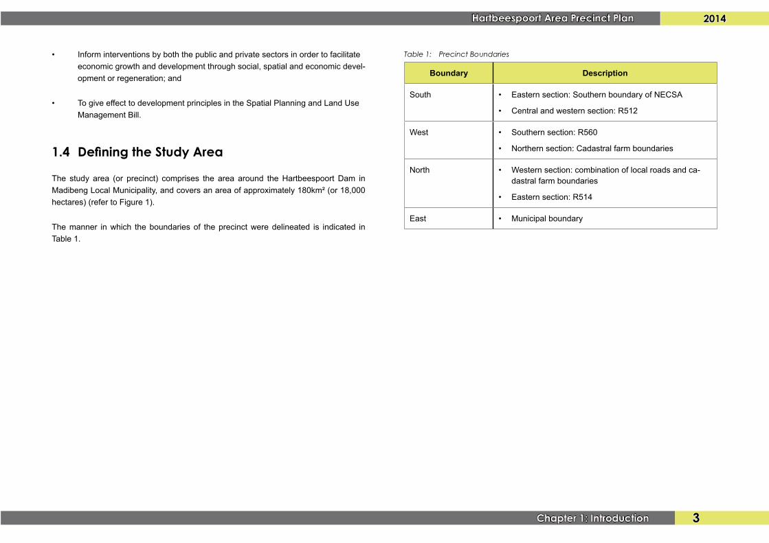
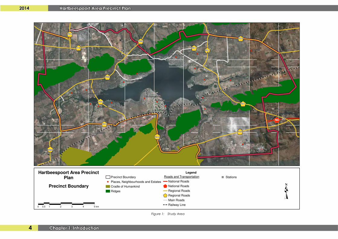
1.4 Defining the Study Area
The study area (or precinct) comprises the area around theHartbeespoort Dam inMadibengLocalMunicipality,andcoversanareaofapproximately180km²(or18,000hectares)(refertoFigure1).
Themanner inwhich theboundariesof theprecinctweredelineated is indicated inTable1.
Table 1: Precinct Boundaries
Boundary Description
South • Easternsection:SouthernboundaryofNECSA
• Centralandwesternsection:R512
West • Southernsection:R560
• Northernsection:Cadastralfarmboundaries
North • Westernsection:combinationoflocalroadsandca-dastralfarmboundaries
• Easternsection:R514
East • Municipalboundary
2014 Hartbeespoort Area Precinct Plan
4 Chapter 1: Introduction
Figure 1: Study Area
R514R514R514R514R514R514R514R514R514
R511R511R511R511R511R511R511R511R511
R511R511R511R511R511R511R511R511R511
R511R511R511R511R511R511R511R511R511
R560R560R560R560R560R560R560R560R560
R512R512R512R512R512R512R512R512R512
R512R512R512R512R512R512R512R512R512
R512R512R512R512R512R512R512R512R512
R560R560R560R560R560R560R560R560R560
R104R104R104R104R104R104R104R104R104
R560R560R560R560R560R560R560R560R560
R104R104R104R104R104R104R104R104R104
R512R512R512R512R512R512R512R512R512
N4
Xanadu Eco ParkXanadu Eco Park
Lakeland EstateLakeland Estate
NECSANECSA
SunwaySunway
KosmosKosmos
SchoemansvilleSchoemansville
West Lake EstateWest Lake Estate
Heron CoveHeron Cove
Leloko EstateLeloko Estate
Magalies Golf Estate and River ClubMagalies Golf Estate and River Club
Caribbean BeachCaribbean Beach
The Island EstateThe Island Estate
MelodieMelodie
Melodie AHMelodie AH
Ville D'AfricqueVille D'AfricqueEagles LandingEagles Landing
PecanwoodPecanwood
IfafiIfafi
MeerhofMeerhof
N4N4N4N4N4N4N4N4N4
XanaduXanaduXanaduXanaduXanaduXanaduXanaduXanaduXanadu
DamsigDamsigDamsigDamsigDamsigDamsigDamsigDamsigDamsig
Hartbeespoort Area PrecinctPlan
0 0.5 1 2 3 4 5 km
NPrecinct Boundary
Legend
Precinct Boundary
Places, Neighbourhoods and Estates
Cradle of Humankind
Ridges
Roads and Transportation
National Roads
National Roads
Regional Roads
Regional Roads
Main Roads
Railway Line
Stations

Chapter 2: Context

2014 Hartbeespoort Area Precinct Plan
6 Chapter 2: Context
Chapter 2: Context
2.1 Administrative Context
TheAdministrativecontextoftheprecinctissetoutinTable2andFigure2.
Table 2: Administrative Context
Administrative Level
Province NorthWestProvince
DistrictMunicipality BojanalaPlatinumDistrictMunicipality
LocalMunicipality MadibengLocalMunicipality
Municipal Wards Ward29
Ward30
Ward 33
2.2 Regional and Local Context
Theprecinct lies in thesouthernpartofMadibengLocalMunicipality,approximately15kmsouthofBritsalongtheR511,whichisthemainurbancentreinMadibeng.
TheprecinctissituatedontheboundarybetweenNorthWestProvinceandGautengProvince, and is situated in relative close proximity and with good connectivity tomajorurbancentresinGauteng,asindicatedinTable3andFigure4.Theprecinctisalsosituatedapproximately65kmfromRustenburgalongtheN4(Bakwena-PlatinumHighway),whichisoneofthelargereconomiccentresinNorthWestProvince.
Table 3: Distances to Major Regional Urban Centres
Urban Centre Approximate Distance Road Link
Pretoria 35km R104
R514
Sandton 40km R511
Randburg 35km R512
Midrand 40km R511
Krugersdorp 45km R512
Another important feature from a regional tourism perspective, is the relative closeproximityof theprecinct to theLanseria InternationalAirport (situatedapproximately20km to thesouthof theR104atNECSAalong theR512). Lanseria is thesecondmostimportantairportinGautengandoffersahostofcharterservicesaswellasbothdomesticandinternationalflights.
2.3 Policy Context
2.3.1 Madibeng Spatial Development Framework, 2009
TheMadibengLocalMunicipalitySpatialDevelopmentFramework,2009identifiestheHartbeespoort area as an urban area (refer to Figure 5) that has become a primedevelopmentlocation.AccordingtotheSpatialDevelopmentFramework,2009(SDF)developmentshouldbechannelledeasttowardsTshwane.Inaddition,theSDFstates

2014Hartbeespoort Area Precinct Plan
7Chapter 2: Context
Figure 2: Provincial Context
BotswanaBotswanaBotswanaBotswanaBotswanaBotswanaBotswanaBotswanaBotswana
North WestNorth WestNorth WestNorth WestNorth WestNorth WestNorth WestNorth WestNorth West
Northern CapeNorthern CapeNorthern CapeNorthern CapeNorthern CapeNorthern CapeNorthern CapeNorthern CapeNorthern Cape
LimpopoLimpopoLimpopoLimpopoLimpopoLimpopoLimpopoLimpopoLimpopo
Free StateFree StateFree StateFree StateFree StateFree StateFree StateFree StateFree State
GautengGautengGautengGautengGautengGautengGautengGautengGauteng
N14N14N14N14N14N14N14N14N14
N3
N3
N3
N3
N3
N3
N3
N3
N3
N4N4N4N4N4N4N4N4N4
N1
N1
N1
N1
N1
N1
N1
N1
N1
N12N12N12N12N12N12N12N12N12
MafikengMafikeng
KlerksdorpKlerksdorp
VryburgVryburg
ZeerustZeerust
LichtenburgLichtenburg
VentersdorpVentersdorp
PotchefstroomPotchefstroom
RustenburgRustenburg
MidrandMidrandMagaliesburgMagaliesburg
BritsBrits
PretoriaPretoria
PilansbergPilansberg
KurumanKuruman
WelkomWelkom
HartbeespoortArea Precinct
Plan
Legend
North West Province
Madibeng Local Municipality
Hartbeespoort Dam
Study Area
National Roads
Cities and Towns
Provincial Context
N
0 10 40 60 80 100 km
2014 Hartbeespoort Area Precinct Plan
8 Chapter 2: Context
R514R514R514R514R514R514R514R514R514
R511R511R511R511R511R511R511R511R511
R511R511R511R511R511R511R511R511R511
R511R511R511R511R511R511R511R511R511
R560R560R560R560R560R560R560R560R560
R512R512R512R512R512R512R512R512R512
R512R512R512R512R512R512R512R512R512
R512R512R512R512R512R512R512R512R512
R560R560R560R560R560R560R560R560R560
R104R104R104R104R104R104R104R104R104
R560R560R560R560R560R560R560R560R560
R104R104R104R104R104R104R104R104R104
R512R512R512R512R512R512R512R512R512
N4
Xanadu Eco ParkXanadu Eco Park
Lakeland EstateLakeland Estate
NECSANECSA
SunwaySunway
KosmosKosmos
SchoemansvilleSchoemansville
West Lake EstateWest Lake Estate
Heron CoveHeron Cove
Leloko EstateLeloko Estate
Magalies Golf Estate and River ClubMagalies Golf Estate and River Club
Caribbean BeachCaribbean Beach
The Island EstateThe Island Estate
MelodieMelodie
Melodie AHMelodie AH
Ville D'AfricqueVille D'AfricqueEagles LandingEagles Landing
PecanwoodPecanwood
IfafiIfafi
MeerhofMeerhof
292929292929292929
303030303030303030
333333333333333333
N4N4N4N4N4N4N4N4N4
XanaduXanaduXanaduXanaduXanaduXanaduXanaduXanaduXanadu
DamsigDamsigDamsigDamsigDamsigDamsigDamsigDamsigDamsig
Hartbeespoort Area PrecinctPlan
0 0.5 1 2 3 4 5 km
NWards
Legend
Precinct Boundary
Townships
Places, Neighbourhoods and Estates
Wards
Ward 29
Ward 30
Ward 33
Cradle of Humankind
Ridges
Hartbeespoort Dam
Perennial Rivers
Roads and Transportation
National Roads
National Roads
Regional Roads
Regional Roads
Main Roads
Railway Line
Stations
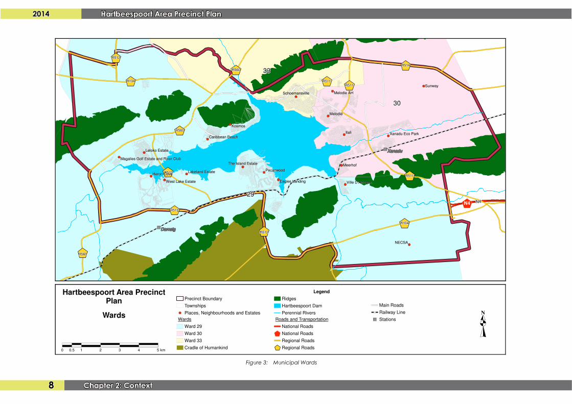
Figure 3: Municipal Wards

2014Hartbeespoort Area Precinct Plan
9Chapter 2: Context
Figure 4: Regional Context

2014 Hartbeespoort Area Precinct Plan
10 Chapter 2: Context
thatalogicalanddesirabledirectionofgrowthwouldhavebeensouthwardsalongtheR511 towards Johannesburg and eastwards towards theTshwaneCBD, but this ispreventedbythedevelopmentrestrictionareaaroundthePelindaba(NECSA)complexaswellastheCradleofHumankindWorldHeritageSite.
ThegeneraldevelopmentobjectivesidentifiedbytheSDFare:
• Accesstoeconomicandsocialopportunities
• CreationofSustainablehumansettlements
• EfficientprovisionofEngineeringservices
• Wellestablishedlinkagesandconnectivity
• Economicdevelopment
• Protectionofenvironmentalasset
Table4setsout theguidelines for thesubdivisionof farmportionsassetout in theMadibengSDF,2009.TheprecinctplanoverlapswithZone2,5,7and8.
Table 4: Madibeng SDF, 2009 Subdivision Guidelines for Farm Portions
Zone No
Zone Minimum Size
1 RuralAreas 20hectares2 High Potential Agricultural
Land20hectares
3 UrbanAreanorthofBrits 1 hectares4 RuralAreasouthofN4 5 hectares5 Urban Area around
HartbeespoortDamIn accordance with Hartbeespoort DamStructurePlan. 5 hectareswherePlan doesnotapply
6 CradleofHumankind 5 hectares as interim measure. SubdivisionguidelinesintheEnvironmentalManagementFrameworkforthisareashallapply
7 PelindabaRestrictionZone 20hectares
Zone No
Zone Minimum Size
8 SouthofN4,betweenR511and R512
3 hectares
2.3.2 Hartbeespoort Dam Structure Plan, 1997
The Hartbeespoort Dam Structure Plan makes a number of detailed developmentproposals for the areas around the dam, which includes varying degrees of urbanandresidentialdevelopmentarounddifferentpartsofthedam(refertoFigure6).Thedocumentalsoindicatesdesirabledevelopmentsdensitiesforvariousareas.
2.3.3 Madibeng Environmental Management Framework, 2009
TherationalefortheEnvironmentalManagementFramework(EMF)isbasedonthefactthatthe-
“municipality is experiencing development pressure, especially along the south through to the eastern boundaries, which is threatening the sustainability of its natural resources. As a result, one of the main aims of the EMF would be to define the envi-ronmental limits within which development can occur and the levels of environmental quality beyond which development cannot be sustained. This will be achieved by en-suring that the EMF is used to pro-actively plan development expansion in a sustain-
able manner.”
TheEMFidentifiedfourdevelopmentconstraintzones(DCZ)for themunicipality,asindicated inTable5andFigure7.Pleasenote that the recommended landusesasindicatedinthistablemerelyrepresentsasummaryofthelandusesindicatedintheEMF,andtheEMFitselfshouldbeconsulted fordetailed informationregarding landusesinspecificareas.