Embed Size (px)
Citation preview
Precinct APrecinct A
Precinct CPrecinct C
Precinct DPrecinct D
Adams Creek
Adams Creek
Precinct EPrecinct E Precinct FPrecinct F
Precinct GPrecinct G
Precinct H
Precinct APrecinct A
Precinct BPrecinct B
Precinct CPrecinct C
Precinct DPrecinct D
Precinct EPrecinct E Precinct FPrecinct F
Precinct GPrecinct G
Precinct H
PRIMARY SCHOOLPRIMARY SCHOOL
PONY CLUBPONY CLUB
POST OFFICEPOST OFFICE
HALLHALL
TOBY’S PADDOCKTOBY’S PADDOCK
GENERAL STOREGENERAL STORE
RAILWAY BUILDINGRAILWAY BUILDING
RECREATION RESERVERECREATION RESERVE
SPEEDWAYSPEEDWAY
CEMETERYCEMETERY
CFACFA
LEGEND
Precinct Boundaries
Railway Line
Public Open Space*
Lots within 400m of Public Open Space
Key Service/Building
Gateway into Nyora
Environmental Issues
Flood Prone Land(18% Annual Exceedance Probability^)
Flood Prone Land(1% Annual Exceedance Probability^)
Vegetation
Giant Gippsland Earthworm Patches
Road Surface:
Sealed
Unsealed
Unmade Road Reserve
*Public Open Space refers to publicly accessible land set aside for sport, recreation and community purposes and may include parklands, sporting fields, playgrounds, bushland and built areas such as civic squares, plazas or skate parks.
^Annual Exceedance Probability is the likelihood that a given rainfall total accumulated over a given duration will be exceeded in any one year. For example, a one-hundred-year flood is a flood event that has a 1% probability of occurring in any given year. The 100-year flood is also referred to as the 1% flood, since its annual exceedance probability is 1%. For river systems, the 100-year flood is generally expressed as a flowrate.
LOCAL CONTEXTNyora is located approximately 100km from Melbourne. It is within easy reach of Cranbourne and Pakenham.
GROWTHPredictions suggest the population in Nyora could grow by 30-90 people per year, depending on the growth scenario.
▪ Installation of the sewerage system
▪ Proximity to Melbourne, Cranbourne and Pakenham, and other regional employment centres
▪ Subdivision and development potential due to sewer connections
▪ Rural township character making it an attractive place for a “tree change”
DEVELOPMENTThere is a need to decide what minimum lot sizes may be created in the existing residential areas to accommodate some growth.
RAILWAY LANDWe need to talk about what will happen to the railway land, which is Crown land owned by VicTrack, and the heritage railway buildings.
STORMWATERThere are stormwater and drainage issues across the town that already need to be addressed.
SERVICESCommunity services and retail are needed in the town centre, for its current and future population.
DRIVERS FOR CHANGE
As the population grows, more housing will be needed.
ISSUES AND OPPORTUNITIES
EXISTING CONDITIONS
OR
MITCHELL STREETMITCHELL STREET
YAN
NAT
HA
N R
OA
DYA
NN
ATH
AN
RO
AD
LANG LANG-POOWONG ROAD
LANG LANG-POOWONG ROAD
LANG LANG-NYORA ROAD
LANG LANG-NYORA ROAD
FORS
TER
ROA
DFO
RSTE
R RO
AD
HAT
CHS
ROA
DH
ATCH
S RO
AD
GLOVERS ROAD
GLOVERS ROAD
HEN
LEY
STRE
ETH
ENLE
Y ST
REET
DAV
IS S
TREE
TD
AVIS
STR
EET
WATTS ROADWATTS ROAD
GRUNDY ROAD
GRUNDY ROAD
BERRYS ROAD
BERRYS ROAD
HEN
RYS
ROA
DH
ENRY
S RO
AD
HEWSON STREETHEWSON STREET
WA
LTER
S RO
AD
WA
LTER
S RO
AD
PRECINCT FPRECINCT F
PRECINCT DPRECINCT D
PRECINCT EPRECINCT E
PRECINCT APRECINCT A
PRECINCT BPRECINCT BPRECINCT CPRECINCT C
PRECINCT HPRECINCT H
PRECINCT GPRECINCT G
The growth area in Precinct F proposed to the north east is known locally as the Wallace Watson land. The Planning Scheme Amendment to rezone this land is currently with the Planning Minister for determina on. The plan above is an indica ve layout which shows how residen al development in the Precinct F land could be laid out in future.
The above plan illustrates the focus of the Nyora Development Strategy. Community input is of par cular importance for the areas in darker green. The strategy will provide more detailed guidance for these areas. Guidance will also be provided for precincts C and D, though growth in these areas is expected much further in the future. Precincts G and H are not expected to experience addi onal growth.
OVERALL STRATEGY MAP
EE
DD
FF
GG
HH
BB
AACC
Precinct A
Precinct B
Precinct C
Precinct D
Precinct E Precinct F
Precinct G
Precinct H
PRIMARY SCHOOL
PONY CLUB
POST OFFICE
HALL
TOBY’S PADDOCK
GENERAL STORE
RAILWAY BUILDING
RECREATION RESERVE
SPEEDWAY
CEMETERY
CFA
LEGEND
Precinct Boundary
Flood Prone Land (5 Year ARI)
Flood Prone Land (100 Year ARI)
Road Surface
Railway Line
Public Open Space (POS)
Key Service/Building
Opportunities
Possible Linear Park - New public open space, constructed waterway for stormwater issues, and movement corridor
Railway corridor
Improved connections
Pedestrian link
Framework areas:
Town centre reconfiguration (Precinct A)
Transition area (Precinct B & E)
Short to medium term growth area (Precinct F)
Long term growth area (Precinct C & D)
Rural lifestyle (Precinct G & H)OVERALL STRATEGY MAP
MITCHELL STREETMITCHELL STREET
HEWSON STREETHEWSON STREET
WATTS ROADWATTS ROAD
GRAYDEN STREETGRAYDEN STREET
WALTERS ROADWALTERS ROAD
LANG LANG-POOWONG ROADLANG LANG-POOWONG ROAD
YAN
NAT
HAN
RO
ADYA
NN
ATH
AN R
OAD
FOR
STER
DR
IVE
FOR
STER
DR
IVE
DAV
IS S
TREE
TD
AVIS
STR
EET
GRUNDY AVENUE
GRUNDY AVENUE
WAL
TER
S R
OAD
WAL
TER
S R
OAD
EY S
TREE
TEY
STR
EET
PP
MITCHELL STREETMITCHELL STREET
HEWSON STREETHEWSON STREET
WATTS ROADWATTS ROAD
GRAYDEN STREETGRAYDEN STREET
WALTERS ROADWALTERS ROAD
LANG LANG-POOWONG ROADLANG LANG-POOWONG ROAD
YAN
NAT
HAN
RO
ADYA
NN
ATH
AN R
OAD
FOR
STER
DR
IVE
FOR
STER
DR
IVE
DAV
IS S
TREE
TD
AVIS
STR
EET
GRUNDY AVENUE
GRUNDY AVENUE
WAL
TER
S R
OAD
WAL
TER
S R
OAD
EY S
TREE
TEY
STR
EET
MITCHELL STREETMITCHELL STREET
HEWSON STREETHEWSON STREET
WATTS ROADWATTS ROAD
GRAYDEN STREETGRAYDEN STREET
WALTERS ROADWALTERS ROAD
LANG LANG-POOWONG ROADLANG LANG-POOWONG ROAD
YAN
NAT
HAN
RO
ADYA
NN
ATH
AN R
OAD
FOR
STER
DR
IVE
FOR
STER
DR
IVE
DAV
IS S
TREE
TD
AVIS
STR
EET
GRUNDY AVENUE
GRUNDY AVENUE
WAL
TER
S R
OAD
WAL
TER
S R
OAD
Y ST
REE
TY
STR
EET
DAV
IS S
TREE
TD
AVIS
STR
EET
YAN
NAT
HA
N R
OAD
YAN
NAT
HA
N R
OAD
LANG LANG-POOWONG ROAD
LANG LANG-POOWONG ROAD
MITCHELL STREET
MITCHELL STREET
WATTS ROADWATTS ROAD
FOR
STER
RO
ADFO
RST
ER R
OAD
PATM
AN D
RIV
EPA
TMAN
DR
IVE
HAT
CH
S R
OAD
HAT
CH
S R
OAD
GRAYDEN STREETGRAYDEN STREET
WAL
TER
S R
OAD
WAL
TER
S R
OAD
HEN
LEY
STR
EET
HEN
LEY
STR
EET
HEWSON STREETHEWSON STREET GRUNDY AVENUE
GRUNDY AVENUE
Post OfficePost Office
Primary SchoolPrimary School
HallHall
Toby’s PaddockToby’s Paddock
General StoreGeneral Store
Railway BuildingRailway Building
Recreation ReserveRecreation Reserve
SpeedwaySpeedway
CFACFA
LEGEND
Proposed new town centre boundary
Streetscape improvements:
New main street focus
New pedestrian/shared links
Improved junction/intersection layout
Other improvements:
Building frontages
Stormwater/drainage management
Land Uses:
Community
Formal green space
Retail anchor (e.g. supermarket)
Small scale retail space
Train Station reuse
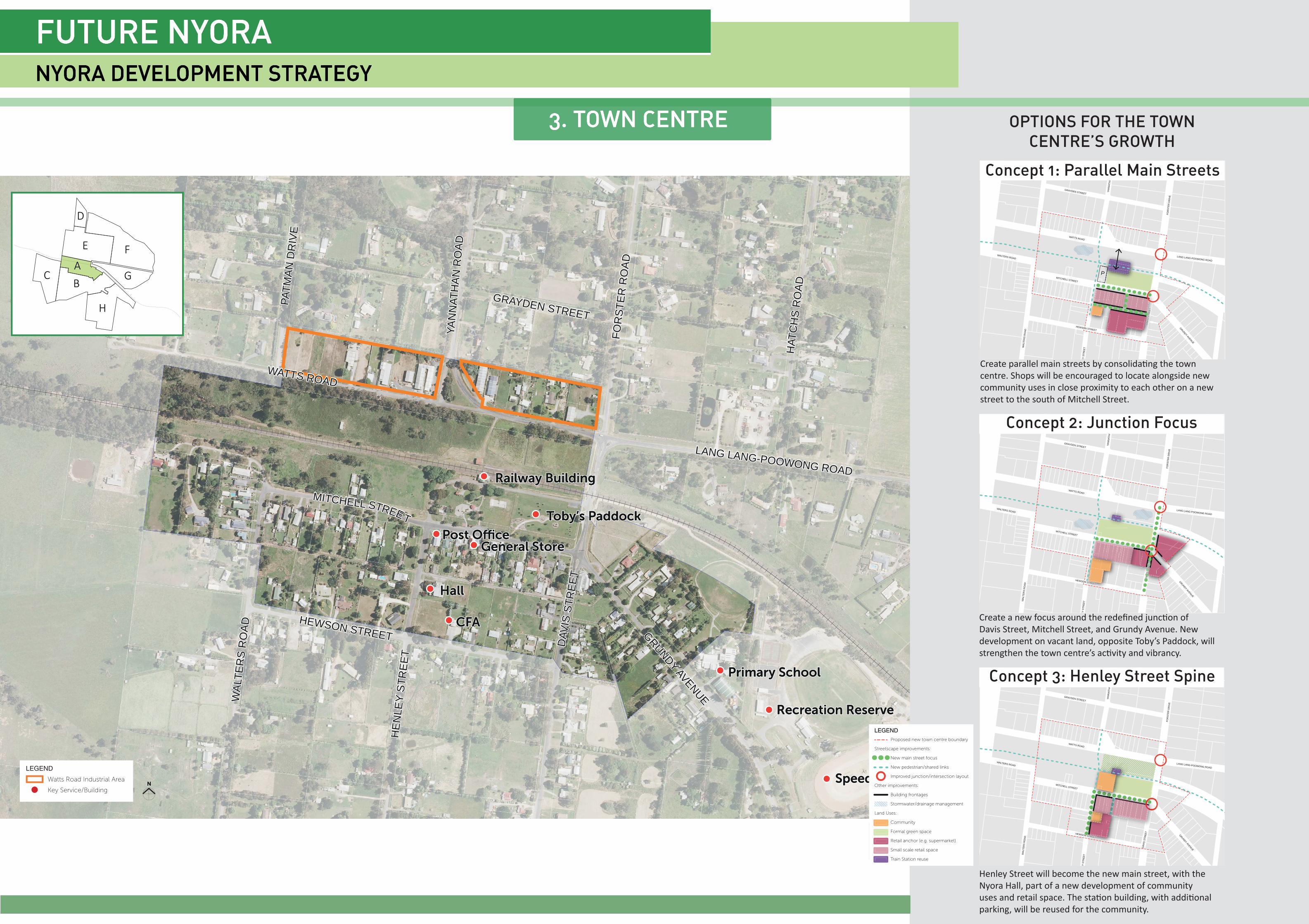
Concept 1: Parallel Main Streets
OPTIONS FOR THE TOWN
CENTRE’S GROWTH
Concept 2: Junction Focus
Create parallel main streets by consolida ng the town centre. Shops will be encouraged to locate alongside new community uses in close proximity to each other on a new street to the south of Mitchell Street.
Create a new focus around the redefi ned junc on of Davis Street, Mitchell Street, and Grundy Avenue. New development on vacant land, opposite Toby’s Paddock, will strengthen the town centre’s ac vity and vibrancy.
Henley Street will become the new main street, with the Nyora Hall, part of a new development of community uses and retail space. The sta on building, with addi onal parking, will be reused for the community.
EE
DD
FF
GG
HH
BB
AACC
Concept 3: Henley Street Spine
LEGEND
Watts Road Industrial Area
Key Service/Building
11
22
LEGEND
Precinct Boundary
Land covered by an existing Development Plan Overlay (DPO5)
Precincts B and C
Other precincts
Existing roads (sealed)
Existing roads (unsealed)
New connections:
Main connector street
New local street
New shared path along linear park
Local Features:
Vegetation
Giant Gippsland Earthworm habitat
Parks and waterways:
Existing parks
New linear park and constructed waterway
Possible future residential development approach:
Township density transition area
Lower density transition area
11
22
WaterwayHouseHouse
Front GardenLinear Park Linear Park
Shar
edPa
th
Verg
e
Front Garden Swale Buffer BufferStreet
Foot
path
Foot
path
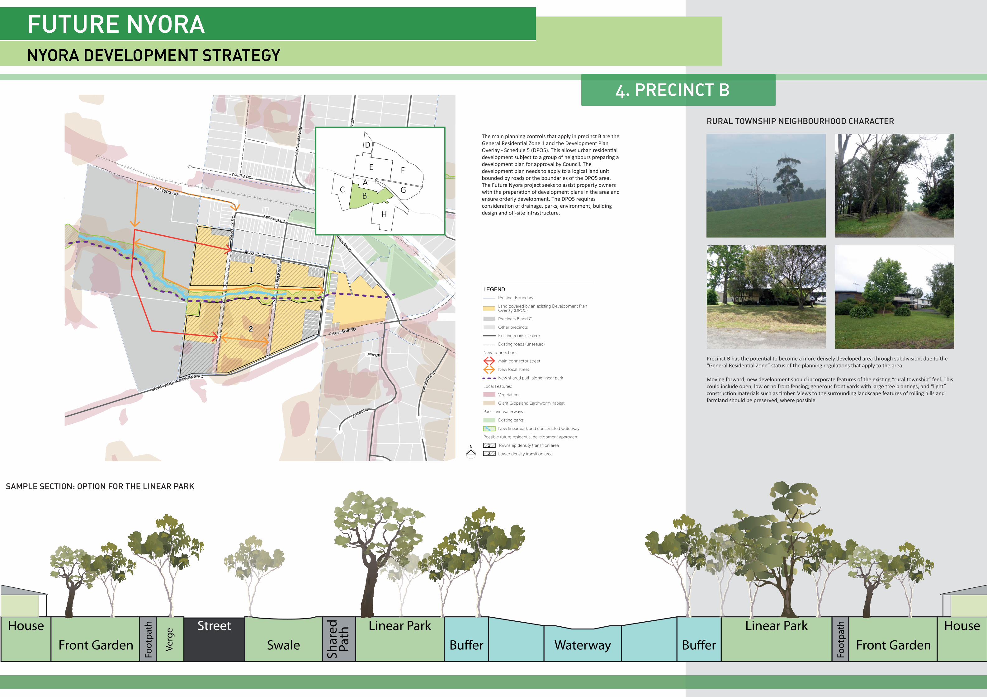
Precinct B has the poten al to become a more densely developed area through subdivision, due to the “General Residen al Zone” status of the planning regula ons that apply to the area.
Moving forward, new development should incorporate features of the exis ng “rural township” feel. This could include open, low or no front fencing; generous front yards with large tree plan ngs, and “light” construc on materials such as mber. Views to the surrounding landscape features of rolling hills and farmland should be preserved, where possible.
RURAL TOWNSHIP NEIGHBOURHOOD CHARACTER
SAMPLE SECTION: OPTION FOR THE LINEAR PARK
The main planning controls that apply in precinct B are theGeneral Residen al Zone 1 and the Development PlanOverlay - Schedule 5 (DPO5). This allows urban residen aldevelopment subject to a group of neighbours preparing adevelopment plan for approval by Council. Thedevelopment plan needs to apply to a logical land unitbounded by roads or the boundaries of the DPO5 area.The Future Nyora project seeks to assist property ownerswith the prepara on of development plans in the area andensure orderly development. The DPO5 requiresconsidera on of drainage, parks, environment, buildingdesign and off -site infrastructure.
EE
DD
FF
GG
HH
BB
AACC
A d a m s C r ee k
WALTERS ROAD
WALTERS ROAD
PRIMARY SCHOOL
PONY CLUB
TOBY’S PADDOCK
RAILWAY BUILDING
RECREATION RESERVE
LEGEND
Precinct boundary
Precincts D, E and F
Other Precincts
Existing roads
Railway line
Watercourse
Key Service/Building
New connections:
Improved Connections
Pedestrian Link
New shared path
Constraints to subdivision (larger lots):
Vegetation
Giant Gippsland Earthworm habitat
Public open space (parks):
Existing public open space
New public open space (proposed)
EE
DD
FF
GG
HH
BB
AACC
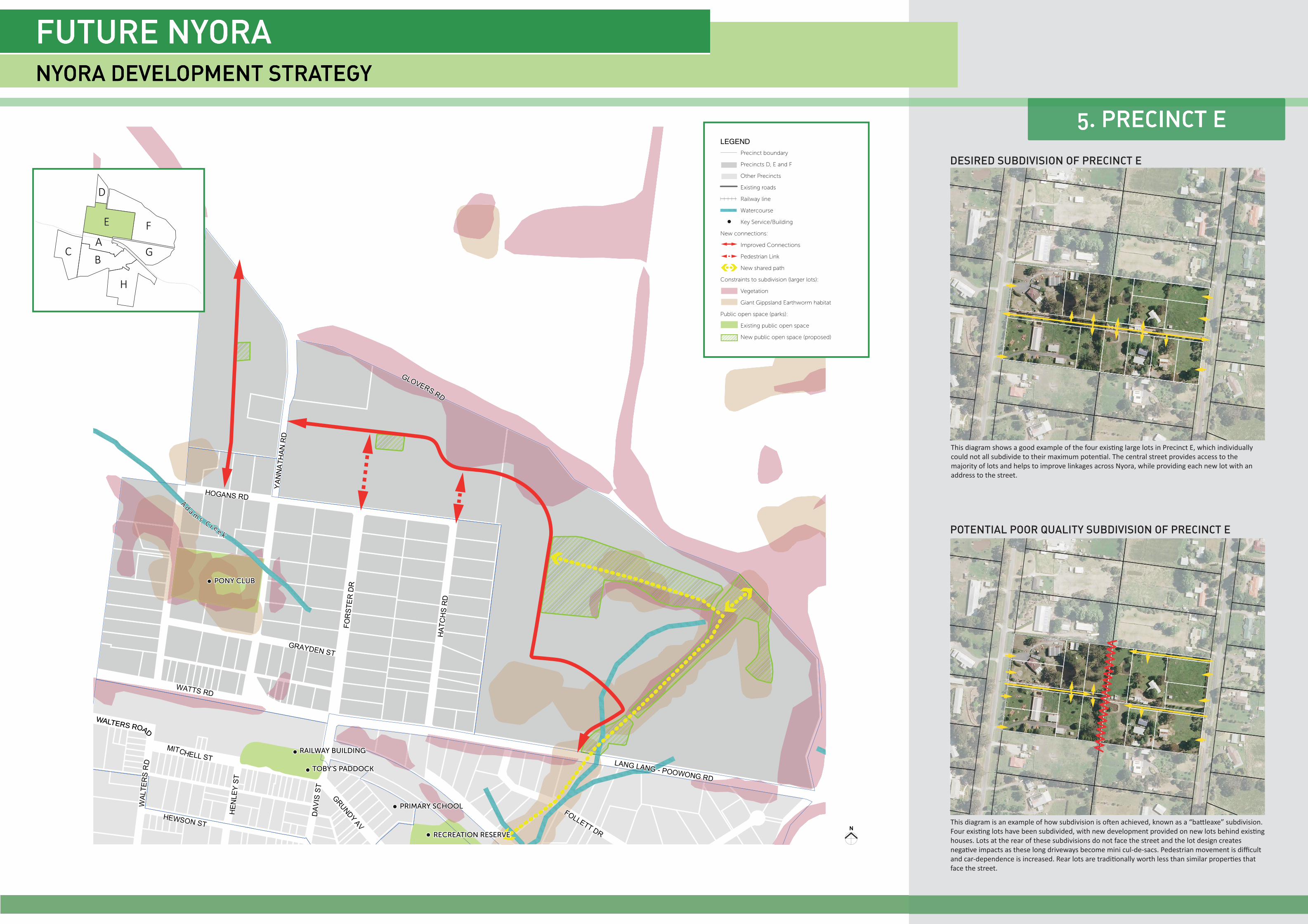
This diagram shows a good example of the four exis ng large lots in Precinct E, which individually could not all subdivide to their maximum poten al. The central street provides access to the majority of lots and helps to improve linkages across Nyora, while providing each new lot with an address to the street.
DESIRED SUBDIVISION OF PRECINCT E
POTENTIAL POOR QUALITY SUBDIVISION OF PRECINCT E
This diagram is an example of how subdivision is o en achieved, known as a “ba leaxe” subdivision. Four exis ng lots have been subdivided, with new development provided on new lots behind exis ng houses. Lots at the rear of these subdivisions do not face the street and the lot design creates nega ve impacts as these long driveways become mini cul-de-sacs. Pedestrian movement is diffi cult and car-dependence is increased. Rear lots are tradi onally worth less than similar proper es that face the street.