Embed Size (px)
Citation preview

1
HandheldHandheld Risk Risk MappingMapping in Sudanin Sudanby Rune Engeset (by Rune Engeset ([email protected]@nve.no))
SudanLargest in AfricaRoads and infrastructureAvoid errorsOpen roads quickly butcontrolled
Risk management

2
ÑÑÑÑÑÑ
ËÙ
ÙÙ
Ù
Ù
ÙÙ
Ù
ÙÙ
Ù
Ù Ù
Ù
Ù
# ##
##
#
##
######## ###### # ##
# ###
# #######
############
########
###
#
############################################
#######################
#############
#########
##
###
##
######
######
####
######
##
###
############
######
###########
################
#############
##########################################################################################
##
#############################################################################################################################################################################################################################################################################################################################################################################################################################################################################################################################################################################################################################################################################################################################################################
##############################
########
######################
#####################################
#########################################################
##########################################################
###########################
################
#####################################################
#################################################################################
###########################################################################################################################################################################################################################
#######################################################################################################
###############################################################################################
##############################
######
####
########## # ########## ##### ###### ###
############# # ## # # ### #################################### ### ####### ###############
##
#
###
#
#
###
##
#
#
##
####
##
##
#####
#
#
####
#
##
###################
###
#########
# #####
#
#
## # # # ## # ## # # #
# #
##
# ###
##
##
#####
##
#
#
##
#
####
##
###
##
#
############ #
####
####
# ### # ######################################
#####################
#############
##
##
##
####
#####
####
###
##
#######
######
####
###############################
##########################################################################################
############################
######################################
################
######
#############################################
#################################
######################
###############
###
##
## ## # ## # # # # # # #### ##### # # # # # # # #### # ## ####
##### ##############
©[
R609
R611
R612
R613
R614R
618
R610
R611
R612
R615
R617
R614
34
33
31
28
29
27
26
25
32
30
105
35
106
37
36
104
34
33
31
28
29
27
26
32
30
42
4 4
35
43
41
40
106
39
38
37
36
0 4 8 12 16 20 Kilometers
32°55'32"32°55'32"
32°57'31"32°57'31"
32°59'30"32°59'30"
33°1'29"33°1'29"
46°27'46"
46°27'46"
46°29'45"
46°29'45"
46°31'44"
46°31'44"
46°33'43"
46°33'43"
46°35'42"
46°35'42"
46°37'41"
46°37'41"636000
636000
638000
638000
640000
640000
642000
642000
644000
644000
646000
646000
648000
648000
650000
650000
652000
652000
654000
654000
3644000 3644000
3646000 3646000
3648000 3648000
3650000 3650000
3652000 3652000
3654000 3654000
3656000 3656000
Risk assessment in Iran
RISIK LEVEL↓
RISIK LEVEL↓
RISIK LEVEL↓

3
Setting the risk level
Definingtolerable risk
Risk level Threat Reliability Accident Use
5 Yes or 1 None or 2 Incomplete or Yes
Unknown and 1, 2 or 3
4
3 No and 3 Incomplete & surveyed and No
2
1 No and 4 Complete and No Red
uced
one
leve
l if d
aily
in
use
by b
us/tr
uck/
car
Developing a new framework for risk management
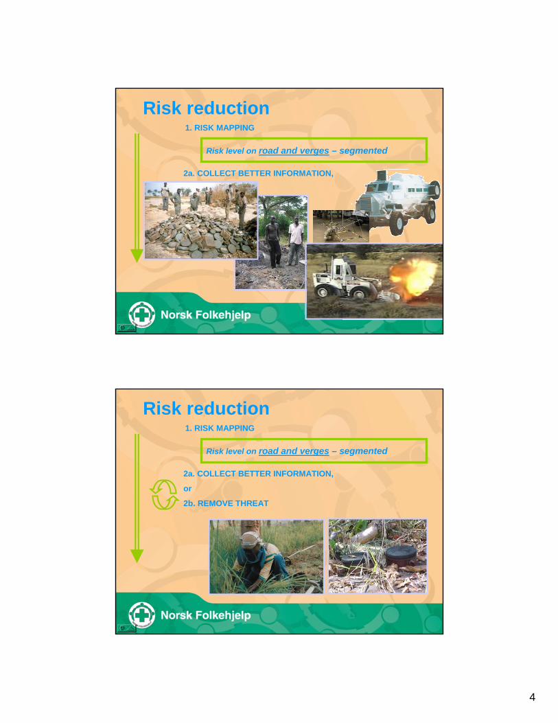
Risk reduction1. RISK MAPPING
Risk level on road and verges – segmented
4
Risk reduction1. RISK MAPPING
Risk level on road and verges – segmented
2a. COLLECT BETTER INFORMATION,
or
2b. REMOVE THREAT
Risk reduction1. RISK MAPPING
Risk level on road and verges – segmented
2a. COLLECT BETTER INFORMATION,
or
2b. REMOVE THREAT

5
Risk reduction
3. RELEASE OF ROADS OR LAND
Low risk level on road and verges
Key elements
A. Divide roads into shorter segmentsB. Mapping of road and verges seperatelyC. Identify HotspotsD. Mapping of useE. AccidentsF. Assessment of the information level – use of key
informantsG. Extend information collection by technical investigationH. Mapping of alternative solutions

6
pointCommunity
pointSafeview
pointBridge
polygonHazardarea
polylineRoad
pointCrossroad
pointLocation
auxRoadinfo
aux'sSubdistrict
DistrictProvince
auxHazard
auxAccident
+ key informants
+ hotspots
Risk Assessment ToolPDAGPS with an external antennaeArcPad* GIS applikationGIS data: Topos & sat.imagery, admin.,
roads, communities, etc.Digital camera

7
Clashes Stockpiles Threats
Not on road or verges
On verges
Road and verges
Setting the risk level - Basics
Information not availableNone1
Unreliable or insufficient information and not visited by surveyIncomplete2
Unreliable or insufficient information and visited by survey teamIncomplete & surveyed3
Reliable and sufficient information*Complete4
Reliability
* To qualify for level 4 a minimum of 4 key informants in 4 separate encounters is required:• 2 village headmen, sub-chiefs or equivalents from one community each side of the segment• 2 separate encounters along the segment• 1 additional encounter per kilometre of road for segments longer than 2 km• Survey team may count as one key informant / encounter• All encounters univocally reports presence or absence of threat (ordnance)
Road landmine/UXO threat: Yes, No or UnknownVerges landmine/UXO threat: Yes, No or Unknown
No if all key informants report absence of threat (no ordnance).Yes if any key informant reports presence of threat (ordnance).Unknown otherwise.
Threat

8
Setting risk levels
Rules to define risk into one of five levels5=High, 4=Medium-high, 3=Medium, 2=Medium-low and 1=Low
Risk is defined for both road and verges for individual segments along road
Risk level Threat Reliability Accident Use
5 Yes or 1 None or 2 Incomplete or Yes
Unknown and 1, 2 or 3
4
3 No and 3 Incomplete & surveyed and No
2
1 No and 4 Complete and No Red
uced
one
leve
l if d
aily
in
use
by b
us/tr
uck/
car
Tolerable risk
Stakeholders define tolerable risk
Tolerable risk
Risk level Threat Reliability Accident Use
5 Yes or 1 None or 2 Incomplete or Yes
Unknown and 1, 2 or 3
4
3 No and 3 Incomplete & surveyed and No
2
1 No and 4 Complete and No Red
uced
one
leve
l if d
aily
in
use
by b
us/tr
uck/
car

9
Risk management
Goal is efficient release of land or roads
Road open
Risk level Threat Reliability Accident Use
5 Yes or 1 None or 2 Incomplete or Yes
Unknown and 1, 2 or 3
4
3 No and 3 Incomplete & surveyed and No
2
1 No and 4 Complete and No Red
uced
one
leve
l if d
aily
in
use
by b
us/tr
uck/
car
Risk reduction
Risk level may be reduced by targeting the items highlighted in yellow
Risk level Threat Reliability Accident Use
5 Yes or 1 None or 2 Incomplete or Yes
Unknown and 1, 2 or 3
4
3 No and 3 Incomplete & surveyed and No
2
1 No and 4 Complete and No Red
uced
one
leve
l if d
aily
in
use
by b
us/tr
uck/
car

10
Reduced risk level
Case I - Absence of threat or unknown
Risk level may be reduced by targeting the items highlighted in yellowa) by collecting more information and thus increasing reliability of information
Degree of sampling: VERY HIGH- threat not found: reduce risk to low- threat found: increase risk to high
Risk level Threat Reliability Accident Use
5 Yes or 1 None or 2 Incomplete or Yes
Unknown and 1, 2 or 3
4
3 No and 3 Incomplete & surveyed and No
2
1 No and 4 Complete and No Red
uced
one
leve
l if d
aily
in
use
by b
us/tr
uck/
car
Case I - Absence of threat or unknown
Risk level may be reduced by targeting the items highlighted in yellowa) by collecting more information and thus increasing reliability of information
Degree of sampling: HIGH- threat not found: reduce risk to low- threat found: increase risk to high
Reduced risk level
Risk level Threat Reliability Accident Use
5 Yes or 1 None or 2 Incomplete or Yes
Unknown and 1, 2 or 3
4
3 No and 3 Incomplete & surveyed and No
2
1 No and 4 Complete and No Red
uced
one
leve
l if d
aily
in
use
by b
us/tr
uck/
car

11
Case I - Absence of threat or unknown
Risk level may be reduced by targeting the items highlighted in yellowa) by collecting more information and thus increasing reliability of information
Degree of sampling: MEDIUM- threat not found: reduce risk to low- threat found: increase risk to high
Reduced risk level
Risk level Threat Reliability Accident Use
5 Yes or 1 None or 2 Incomplete or Yes
Unknown and 1, 2 or 3
4
3 No and 3 Incomplete & surveyed and No
2
1 No and 4 Complete and No Red
uced
one
leve
l if d
aily
in
use
by b
us/tr
uck/
car
Case I - Absence of threat or unknown
Risk level may be reduced by targeting the items highlighted in yellowa) by collecting more information and thus increasing reliability of information
Degree of sampling: LOW- threat not found: reduce risk to low- threat found: increase risk to high
Reduced risk level
Risk level Threat Reliability Accident Use
5 Yes or 1 None or 2 Incomplete or Yes
Unknown and 1, 2 or 3
4
3 No and 3 Incomplete & surveyed and No
2
1 No and 4 Complete and No Red
uced
one
leve
l if d
aily
in
use
by b
us/tr
uck/
car

12
Risk reduced
Case II - Presence of threat
Risk level may be reduced by targeting the items highlighted in yellowa) by collecting more information and thus increasing reliability of informationb) by locating and removing the threat
Reliability level 4 Complete:FULL CLEARANCE
Risk level Threat Reliability Accident Use
5 Yes or 1 None or 2 Incomplete or Yes
Unknown and 1, 2 or 3
4
3 No and 3 Incomplete & surveyed and No
2
1 No and 4 Complete and No Red
uced
one
leve
l if d
aily
in
use
by b
us/tr
uck/
car
Risk reduced
Case II - Presence of threat
Risk level may be reduced by targeting the items highlighted in yellowa) by collecting more information and thus increasing reliability of informationb) by locating and removing the threat
Reliability level 1 No information or 2 Incomplete:HIGH DEGREE OF SAMPLING / TECHNICAL SURVEY
Risk level Threat Reliability Accident Use
5 Yes or 1 None or 2 Incomplete or Yes
Unknown and 1, 2 or 3
4
3 No and 3 Incomplete & surveyed and No
2
1 No and 4 Complete and No Red
uced
one
leve
l if d
aily
in
use
by b
us/tr
uck/
car