Embed Size (px)
Citation preview
Page 1 of 1
Handheld Internet-Based EGNOS Receiver
The First Product of the ESA SISNeT Technology
Felix Toran-Marti (1), Javier Ventura-Traveset (1) and Ruizhi Chen (2)
(1) GNSS-1 Project Office. European Space Agency. Toulouse (France). (2) Finnish Geodetic Institute, Masala (Finland)
ABSTRACT Similarly to other Satellite Based Augmentation Systems (SBAS), EGNOS– the European SBAS – will broadcast augmentation signals for GPS through Geostationary Earth Orbit (GEO) satellites. GEO broadcasting is proved to be an efficient strategy for avionic applications and other modes of transport. For some applications, though, it may be of interest to complement GEO broadcasting through other transmission means. For instance, building obstacles in cities or rural canyons may difficult the GEO reception. In those situations, complementary real-time Internet-based broadcasting of the EGNOS signal is of major interest as a way to continue taking the most of the EGNOS potential, irrespectively of the user environment. In this context, the European Space Agency (ESA) has launched an internal project to provide access to the EGNOS test bed messages through the Internet. The product of this project is a new technology, called SISNeT (Signal-in-Space through the Internet). Thanks to SISNeT, any user with access to the Internet (e.g. through wireless networks – GSM or GPRS –) may access the EGNOS product, irrespectively of the GEO visibility conditions. In this paper, the first product of the ESA SISNeT technology is presented: an EGNOS / SISNeT handheld receiver based on an iPAQ Pocket PC Personal Digital Assistant (PDA), integrating a low-cost GPS receiver and a GPRS link to the Internet (in the form of PCMCIA cards). After a general description of this development, the receiver software is explained in more technical detail, and experimental results are presented. As it will be shown throughout this paper, this PDA-based device has confirmed that an EGNOS-SISNeT powered receiver significantly improves the accuracy obtained from a GPS-only receiver, remarkably in urban areas.
1 Introduction EGNOS, the European Geostationary Navigation Overlay Service [1], is the first step on the European contribution to the Global Navigation Satellite System (GNSS), and a fundamental stepping-stone towards GALILEO,
Page 2 of 2
Europe’s own Global Navigation Satellite System. EGNOS is an augmentation system to the GPS and GLONASS Satellite Navigation systems, which provides and guarantees navigation signals for aeronautical, maritime and land mobile Trans-European network applications. In addition to EGNOS, there are two other Satellite-Based Augmentation Systems (SBAS) contributing to GNSS-1: the US Wide Area Augmentation System (WAAS) and the Japanese MTSAT Augmentation System (MSAS). Since February 2000, a pre-operational EGNOS signal is available through the so-called EGNOS System Test Bed (ESTB) [2-4]. The ESTB has proven to be an excellent vehicle to demonstrate the system operation to final users. Since year 2000, a number of demonstrations have been performed involving a large variety of user communities and, therefore, of user requirements. In particular, successful demonstrations were performed for land mobile, civil aviation, helicopters, trains, maritime and precision farming [2-4]. Similarly to other Satellite Based Augmentation Systems, EGNOS– the European SBAS – will broadcast augmentation signals to GPS through Geostationary (GEO) satellites. GEO broadcasting is proved to be an efficient strategy for avionic applications and other modes of transport. For some applications, though, it may be of interest to complement GEO broadcasting through other transmission means. For instance, building obstacles in cities or rural canyons may difficult the GEO reception. In those situations, complementary means of broadcasting (e.g. FM, Digital Audio Broadcasting – DAB – and the Internet) have a remarkable interest. In this context, the European Space Agency (ESA) has launched, an internal project to provide access to the ESTB messages in real time through the Internet. The product of this project is a new technology, called SISNeT (Signal in Space through the Internet [5 - 15]). The first product of the ESA SISNeT technology is a handheld EGNOS-SISNeT receiver [19] based on a PDA device, equipped with a GPRS wireless link to the Internet. This paper presents this development, including details on its software architecture and the obtained experimental results (which reveal a remarkable accuracy improvement with respect to GPS-only solutions).
2 The EGNOS System The European Tripartite Group (ETG) – formed by the European Space Agency (ESA), the European Commission and EUROCONTROL – is implementing, via the EGNOS project [1], the European contribution to the Global Navigation Satellite System (GNSS-1). The EGNOS system will provide and guarantee navigation signals for aeronautical, maritime and land mobile Trans-European network applications. On behalf of this tripartite group, ESA is responsible for the system design, development and technical validation of an Advanced Operational Capability (AOC) of the EGNOS system. Technical validation will be completed in early 2004, making possible the operational use of the EGNOS Signal in 2004.
Page 3 of 3
EGNOS will significantly improve the GPS services, in terms of accuracy, (from a typical performance of 20 meters to 1 - 2 meters), service guarantee and safety (via integrity signal) and availability (via additional ranging signals). It will operate on the GPS L1 frequency, and will subsequently be receivable by standard GPS front-ends. In addition to EGNOS, there are two other Satellite-Based Augmentation Systems (SBAS) contributing to GNSS-1: the US Wide Area Augmentation System (WAAS) and the Japanese MTSAT Augmentation System (MSAS). Although all SBAS are currently defined as regional systems, it is commonly recognized the need to establish adequate co-operation / co-ordination among the different systems, so that their implementation becomes more effective and part of a seamless world-wide navigation system. The EGNOS system includes specific requirements, so that interoperability may be achieved. In addition to interoperability, EGNOS has built-in expansion capability to enable extension of the services over regions within the broadcast area of the Geostationary (GEO) satellites used. The EGNOS coverage will first be the ECAC (European Civil Aviation Conference) area, and could be later extended to include other regions such as Africa, Eastern countries, and Russia. EGNOS will meet many of the current positioning, velocity and timing requirements of the land, maritime and aeronautical modes of transport in the European Region. EGNOS is the first step of the European Satellite Navigation strategy and a major stepping-stone towards GALILEO, the future European satellite navigation constellation, planned to be fully deployed and operational in 2008.
3 The EGNOS System Test Bed (ESTB) The EGNOS System Test Bed (ESTB) [2 - 4] is a real-time prototype of EGNOS. It provides the first continuous GPS augmentation service within Europe, and constitutes a great step forward for the European strategy to develop the future European Satellite Navigation Systems: EGNOS and GALILEO. The ESTB objectives include:
?? Support to EGNOS design. In particular, algorithm design benefits from the ESTB experience in design and usage.
?? Demonstration of the system capabilities to users. The ESTB
constitutes a strategic tool for the ETG, which plans to promote the use of EGNOS and analyse its capabilities for different applications. In particular, ESTB availability allows Civil Aviation authorities to adapt their infrastructure and operational procedures for future EGNOS use when it becomes operational. A specific workshop sponsored by ESA, aiming at fostering the use of ESTB and analysing the needs of
Page 4 of 4
potential users, was successfully organized on July 2000. Second and third ESTB Workshops took place in November 2001 and November 2002, respectively, at Nice (France).
?? Analysis of future EGNOS upgrades.
?? Acting as a backbone for continuous EGNOS experimentation and
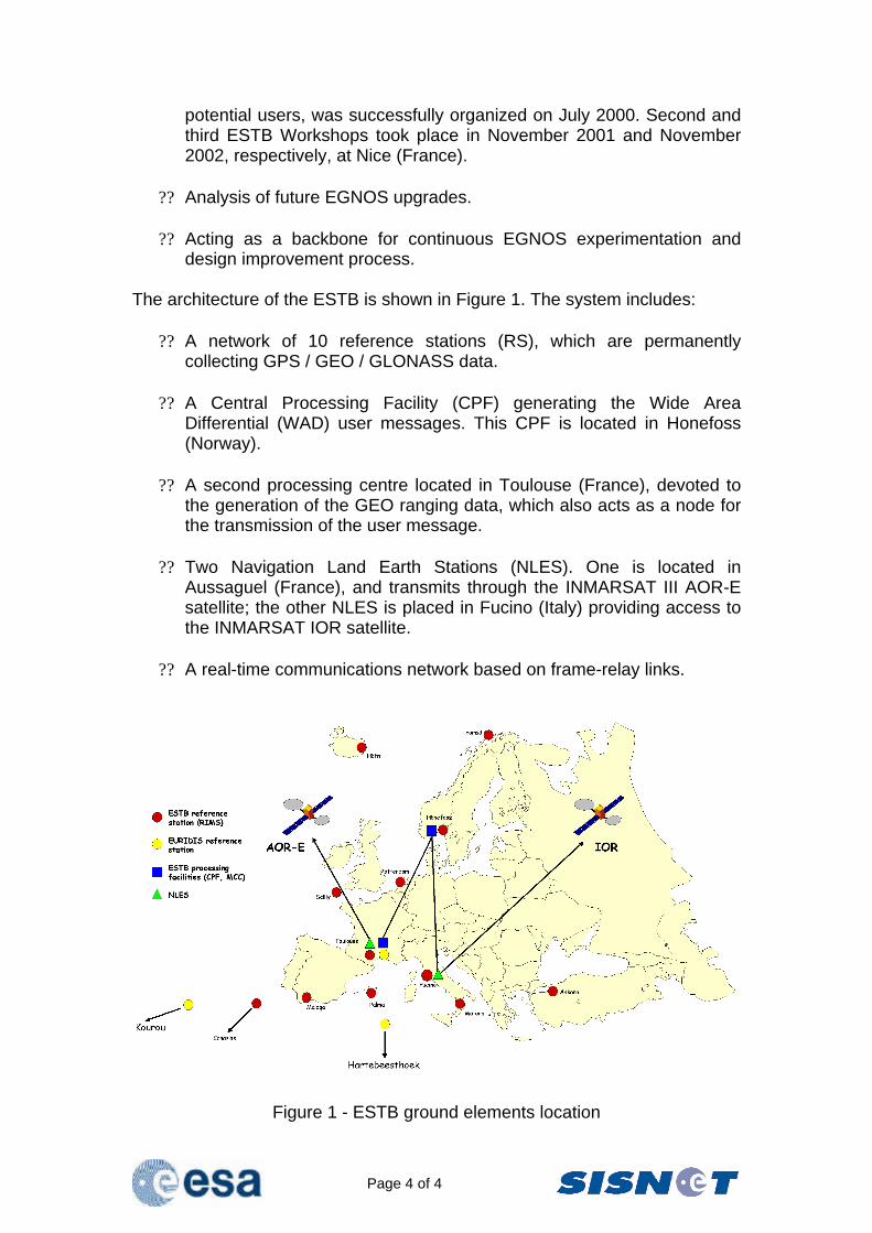
design improvement process. The architecture of the ESTB is shown in Figure 1. The system includes:
?? A network of 10 reference stations (RS), which are permanently collecting GPS / GEO / GLONASS data.
?? A Central Processing Facility (CPF) generating the Wide Area
Differential (WAD) user messages. This CPF is located in Honefoss (Norway).
?? A second processing centre located in Toulouse (France), devoted to
the generation of the GEO ranging data, which also acts as a node for the transmission of the user message.
?? Two Navigation Land Earth Stations (NLES). One is located in
Aussaguel (France), and transmits through the INMARSAT III AOR-E satellite; the other NLES is placed in Fucino (Italy) providing access to the INMARSAT IOR satellite.
?? A real-time communications network based on frame-relay links.
Figure 1 - ESTB ground elements location
Page 5 of 5
4 The SISNeT Technology EGNOS will broadcast their wide-area / integrity messages through GEO satellites. The ESTB is already broadcasting the EGNOS message through the INMARSAT III AOR-E and IOR GEO satellites. Satellite broadcasting through GEO means is proved to be an efficient strategy for avionic applications and other modes of transport. For some applications, though, GEO broadcasting may provide some limitations. For instance, building obstacles in cities or rural canyons may difficult the GEO reception. Since the EGNOS message will still be very useful for those applications, a complementary transmission link may be considered to take the utmost advantage of the EGNOS potential. For this reason, ESA launched specific contract activities (through the Advanced System Telecommunication Equipment program –ASTE–) to assess and demonstrate architectures where the ESTB signal is broadcast through non-GEO means (e.g. FM or GSM broadcasting). In this context, ESA launched (in 2001) an internal project to provide access to the EGNOS test bed messages through the Internet. The product of this project is a new technology, called SISNeT (Signal in Space through the Internet) [5 – 15]. A first prototype of the SISNeT concept was set-up by the ESA GNSS-1 Project Office, in August 2001. Since February 2002, the SISNeT service is accessible through the open Internet, via an authentication procedure. SISNeT accounts are free of charge, and can be requested by contacting the SISNeT team at [email protected]. Each account consists on a username, a password, the IP address of the SISNeT Data Server and the port to use. The SISNeT project is managed from the EGNOS Project Office (Toulouse, France), where the full platform design and development takes place. Maintenance of the SISNeT platform components is performed from the ESA ESTEC centre (Noordwijk, The Netherlands). The SISNeT project can grant important advantages to the GPS land-user community. As this paper will bring to light, a user equipped with a GPS receiver and a GSM (or GPRS) modem can access the SISNeT services, thus being able to benefit from the EGNOS augmentation signals, even under situations of GEO blocking. On the other hand, the Scientific and Engineering community may find major advantages in using SISNeT: the EGNOS signal can be received and processed without having to invest in an EGNOS receiver. Just a connection to the Internet is necessary. These benefits are also applicable to Educational environments (e.g. laboratory exercises based on the EGNOS signal do not imply acquiring receivers, only requiring computers connected to the Internet). Another advantage is centred in the low bandwidth requirements of SISNeT: the transfer rate ranges from 300 bps to 700 bps, being 470 bps the average
Page 6 of 6
value. These characteristics make SISNeT very adequate to be used with GSM / GPRS wireless networks. At the time of this writing (March 2003), version 3.0 of the SISNeT platform is under test (official release planned in May 2003). The new improvements will allow dramatically optimising bandwidth usage. In addition, SBAS receiver time-to-first-fix parameter will be noticeable reduced (typically achieving less than 30 seconds in the case of using a GSM link). For extensive general and technical information about the SISNeT technology, the reader is addressed to references [5-16, 19-22].
5 SISNeT-Based Industrial Activities Since the announcement of the service accessibility through the open Internet (in February 2002), the first release of the SISNeT platform has been complemented with a number of industrial activities. The following are some of the projects ongoing under ESA contracts:
?? Development of an integrated SISNeT receiver, including a GPS receiver and a GSM / GPRS link to the Internet;
?? Development of real-time software environments for the analysis of the
ESTB messages;
?? Improvement of the SISNeT network in terms of performance, security and confidentiality;
?? Demonstrations of SISNeT receivers embedded into urban buses [21];
?? Demonstration of the benefits of the SISNeT technology for blind
pedestrians [16, 22]; Next Sections focus on the first SISNeT-based industrial development ever done, a PDA-based EGNOS-SISNeT receiver [19], linked to the Internet through GSM / GPRS wireless networks.
6 The First Product of the SISNeT Project: a PDA-Based Handheld Receiver
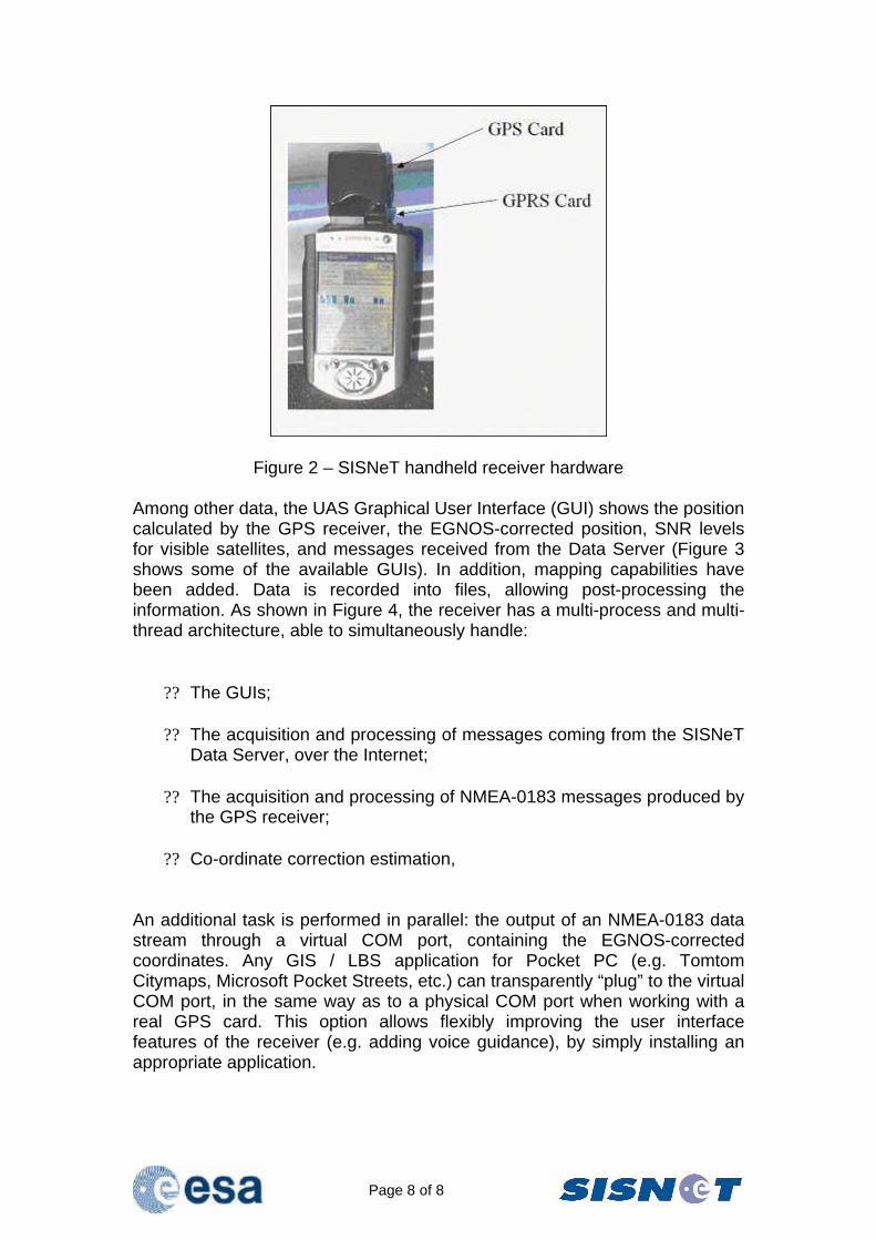
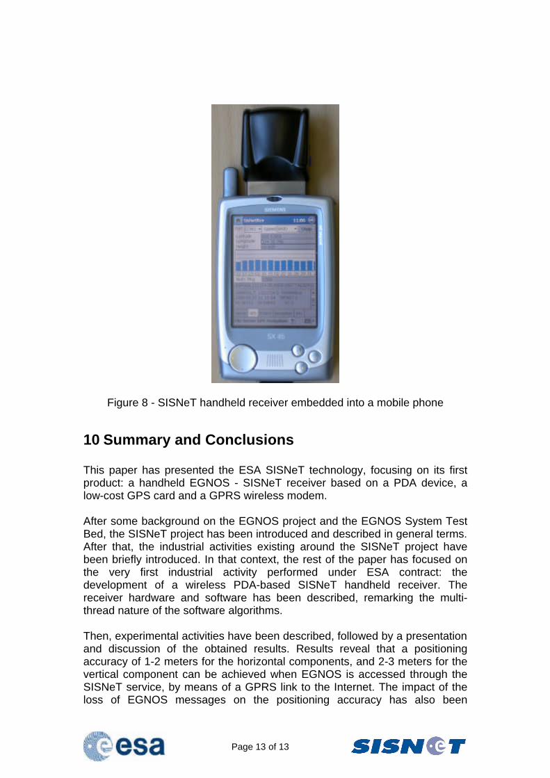
ESA launched the first industrial contract on the SISNeT technology in March 2002, being the Finnish Geodetic Institute (FGI) the contractor. The goal – achieved in July 2002 – was the development of a handheld SISNeT receiver [19], based on an iPAQ Pocket PC Personal Digital Assistant (PDA) device. Receiver hardware (shown in Figure 2) includes a low-cost GPS receiver with integrated antenna, and a GSM / GPRS wireless modem (providing the access to the SISNeT service through the Internet).
Page 7 of 7
The main product of this contract – which is, in fact, the first product of the ESA SISNeT technology – has demonstrated a considerable accuracy improvement with respect to GPS-only solutions, for users located in urban areas. Moreover, experimental results are in line with the estimations obtained through simulation activities (performed in the early phases of the SISNeT project, using the ESA ESPADA [17,18] simulation tool). Specific software has been developed, implementing a SISNeT client application – commonly known as User Application Software or UAS, in the standard SISNeT terminology. This UAS is fully compliant with the specifications stated in the SISNeT User Interface Document [14]. The UAS obtains the EGNOS differential corrections in real-time through the GSM / GPRS link to the SISNeT Data Server (via the Internet). The handheld receiver is equipped with a low-end GPS card, which provides no pseudorange information. Instead, it provides the position of the user and the satellites involved in the navigation solution, in the form of NMEA-0183 messages. Since EGNOS provides corrections in the pseudorange domain, a transformation of the EGNOS corrections to the position domain is necessary. The UAS performs this operation and, finally, calculates the corrected position. In order to determine the position of the GPS satellites, the receiver needs to get the ephemeris information broadcast by the GPS system. Again, low-end receivers do not use to provide this information. Luckily, SISNeT offers a solution to this problem, by making GPS ephemeris data available to users, showing further the potential of this technology. Furthermore, before providing position, the employed GPS card applies corrections based on the GPS ionospheric (Klobuchar) model. Therefore, it is necessary to remove those corrections before applying the EGNOS ionospheric corrections. To do that, it is necessary to know the value of the eight parameters of the Klobuchar model, which are not provided by the employed GPS receiver. Fortunately again, SISNeT is able to provide those parameters to users, mitigating the problem.
7 The Receiver Software The SISNeT handheld receiver software includes the following components:
?? Graphical User Interfaces (GUIs); ?? A communications component; ?? A message processor; ?? A coordinate correction estimator; ?? A virtual COM port, able to output the EGNOS-corrected coordinates in
real time, in the form of NMEA-0183 messages.
Page 8 of 8
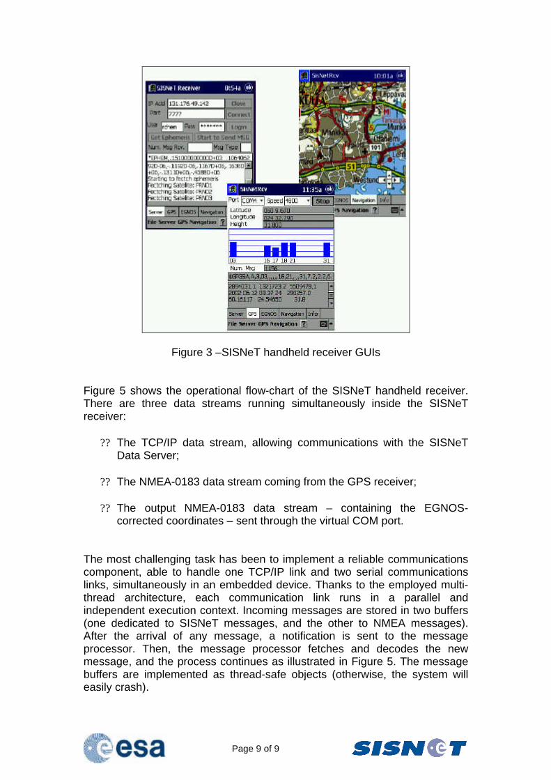
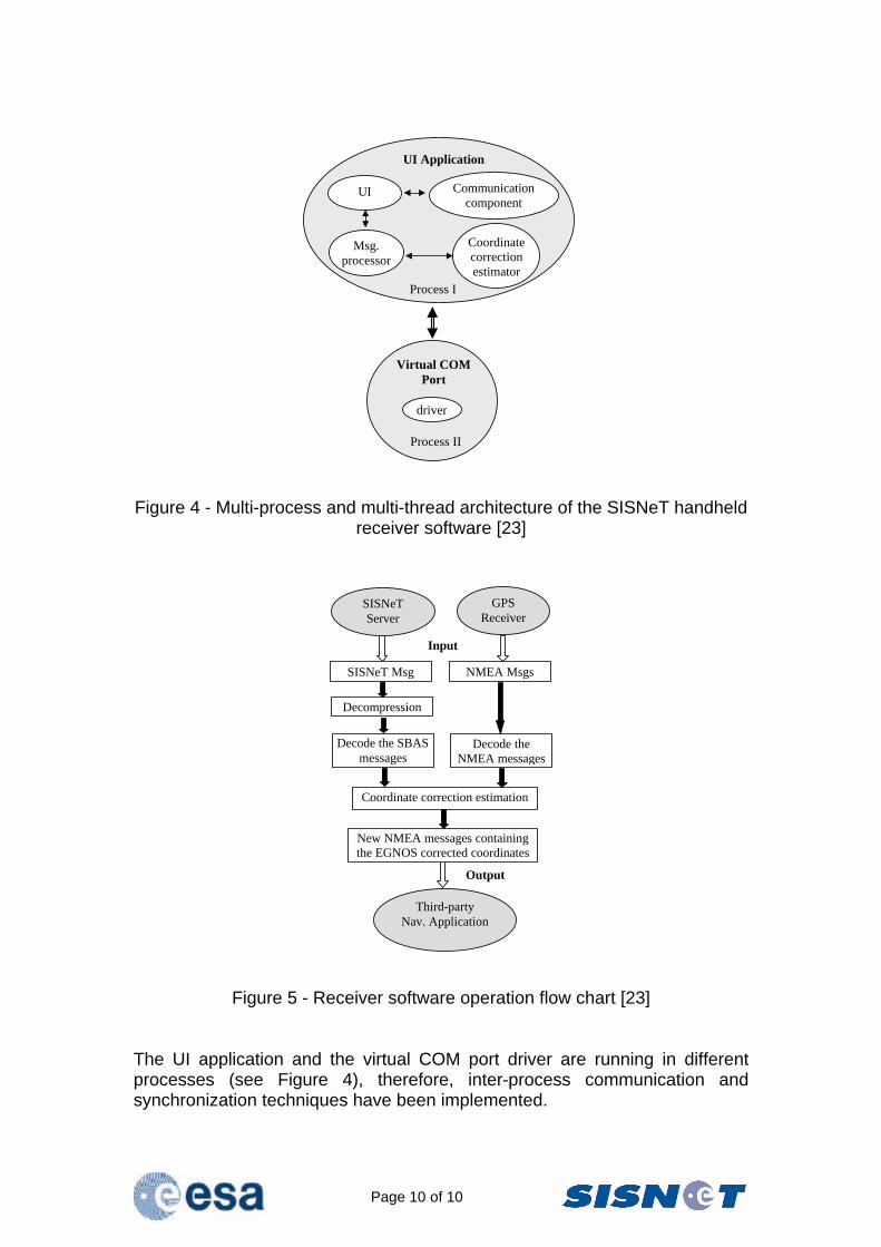
Figure 2 – SISNeT handheld receiver hardware Among other data, the UAS Graphical User Interface (GUI) shows the position calculated by the GPS receiver, the EGNOS-corrected position, SNR levels for visible satellites, and messages received from the Data Server (Figure 3 shows some of the available GUIs). In addition, mapping capabilities have been added. Data is recorded into files, allowing post-processing the information. As shown in Figure 4, the receiver has a multi-process and multi-thread architecture, able to simultaneously handle:
?? The GUIs; ?? The acquisition and processing of messages coming from the SISNeT
Data Server, over the Internet;
?? The acquisition and processing of NMEA-0183 messages produced by the GPS receiver;
?? Co-ordinate correction estimation,
An additional task is performed in parallel: the output of an NMEA-0183 data stream through a virtual COM port, containing the EGNOS-corrected coordinates. Any GIS / LBS application for Pocket PC (e.g. Tomtom Citymaps, Microsoft Pocket Streets, etc.) can transparently “plug” to the virtual COM port, in the same way as to a physical COM port when working with a real GPS card. This option allows flexibly improving the user interface features of the receiver (e.g. adding voice guidance), by simply installing an appropriate application.
Page 9 of 9
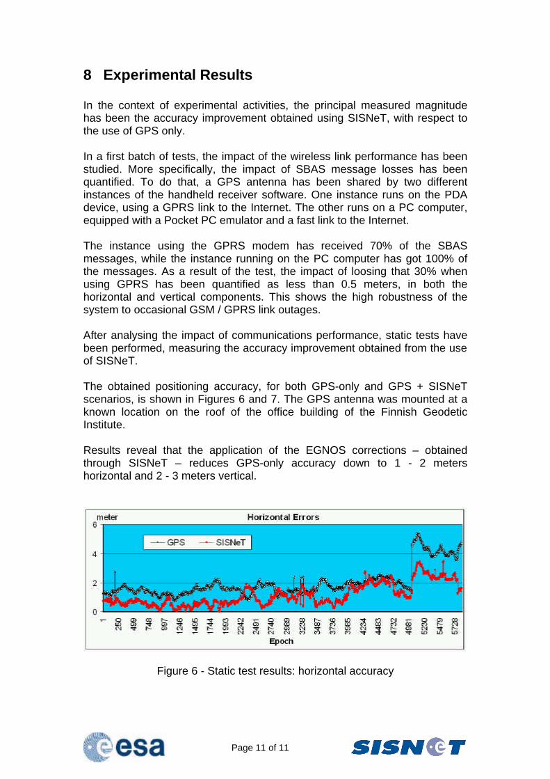
Figure 3 –SISNeT handheld receiver GUIs Figure 5 shows the operational flow-chart of the SISNeT handheld receiver. There are three data streams running simultaneously inside the SISNeT receiver:
?? The TCP/IP data stream, allowing communications with the SISNeT Data Server;
?? The NMEA-0183 data stream coming from the GPS receiver;
?? The output NMEA-0183 data stream – containing the EGNOS-
corrected coordinates – sent through the virtual COM port. The most challenging task has been to implement a reliable communications component, able to handle one TCP/IP link and two serial communications links, simultaneously in an embedded device. Thanks to the employed multi-thread architecture, each communication link runs in a parallel and independent execution context. Incoming messages are stored in two buffers (one dedicated to SISNeT messages, and the other to NMEA messages). After the arrival of any message, a notification is sent to the message processor. Then, the message processor fetches and decodes the new message, and the process continues as illustrated in Figure 5. The message buffers are implemented as thread-safe objects (otherwise, the system will easily crash).
Page 10 of 10
UI Application
UI Communication component
Msg. processor
Coordinate correction estimator
Process I
Virtual COM Port
driver
Process II
Figure 4 - Multi-process and multi-thread architecture of the SISNeT handheld receiver software [23]
SISNeT Msg NMEA Msgs
Decompression
Decode the SBAS messages
Coordinate correction estimation
Decode the NMEA messages
New NMEA messages containing the EGNOS corrected coordinates
SISNeT Server
GPS Receiver
Third-party Nav. Application
Input
Output
Figure 5 - Receiver software operation flow chart [23] The UI application and the virtual COM port driver are running in different processes (see Figure 4), therefore, inter-process communication and synchronization techniques have been implemented.
Page 11 of 11
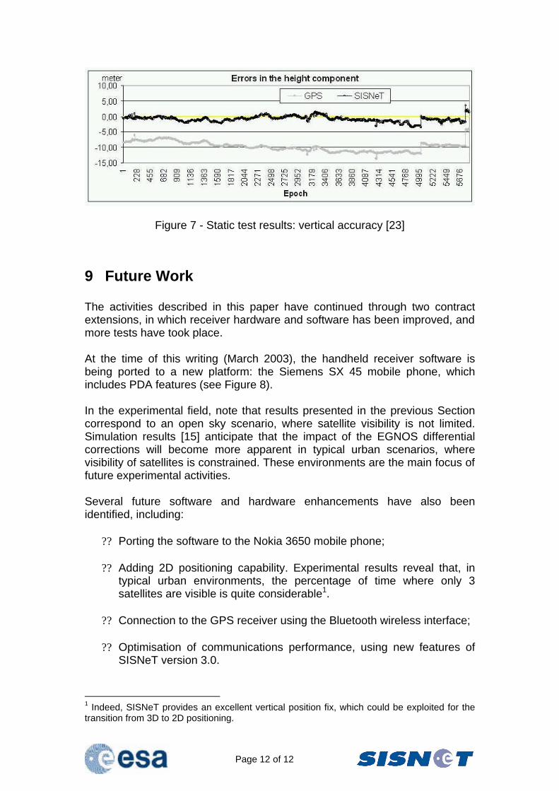
8 Experimental Results In the context of experimental activities, the principal measured magnitude has been the accuracy improvement obtained using SISNeT, with respect to the use of GPS only. In a first batch of tests, the impact of the wireless link performance has been studied. More specifically, the impact of SBAS message losses has been quantified. To do that, a GPS antenna has been shared by two different instances of the handheld receiver software. One instance runs on the PDA device, using a GPRS link to the Internet. The other runs on a PC computer, equipped with a Pocket PC emulator and a fast link to the Internet. The instance using the GPRS modem has received 70% of the SBAS messages, while the instance running on the PC computer has got 100% of the messages. As a result of the test, the impact of loosing that 30% when using GPRS has been quantified as less than 0.5 meters, in both the horizontal and vertical components. This shows the high robustness of the system to occasional GSM / GPRS link outages. After analysing the impact of communications performance, static tests have been performed, measuring the accuracy improvement obtained from the use of SISNeT. The obtained positioning accuracy, for both GPS-only and GPS + SISNeT scenarios, is shown in Figures 6 and 7. The GPS antenna was mounted at a known location on the roof of the office building of the Finnish Geodetic Institute. Results reveal that the application of the EGNOS corrections – obtained through SISNeT – reduces GPS-only accuracy down to 1 - 2 meters horizontal and 2 - 3 meters vertical.
Figure 6 - Static test results: horizontal accuracy
Page 12 of 12
Figure 7 - Static test results: vertical accuracy [23]
9 Future Work The activities described in this paper have continued through two contract extensions, in which receiver hardware and software has been improved, and more tests have took place. At the time of this writing (March 2003), the handheld receiver software is being ported to a new platform: the Siemens SX 45 mobile phone, which includes PDA features (see Figure 8). In the experimental field, note that results presented in the previous Section correspond to an open sky scenario, where satellite visibility is not limited. Simulation results [15] anticipate that the impact of the EGNOS differential corrections will become more apparent in typical urban scenarios, where visibility of satellites is constrained. These environments are the main focus of future experimental activities. Several future software and hardware enhancements have also been identified, including:
?? Porting the software to the Nokia 3650 mobile phone; ?? Adding 2D positioning capability. Experimental results reveal that, in
typical urban environments, the percentage of time where only 3 satellites are visible is quite considerable1.
?? Connection to the GPS receiver using the Bluetooth wireless interface;
?? Optimisation of communications performance, using new features of
SISNeT version 3.0.
1 Indeed, SISNeT provides an excellent vertical position fix, which could be exploited for the transition from 3D to 2D positioning.
Page 13 of 13
Figure 8 - SISNeT handheld receiver embedded into a mobile phone
10 Summary and Conclusions This paper has presented the ESA SISNeT technology, focusing on its first product: a handheld EGNOS - SISNeT receiver based on a PDA device, a low-cost GPS card and a GPRS wireless modem. After some background on the EGNOS project and the EGNOS System Test Bed, the SISNeT project has been introduced and described in general terms. After that, the industrial activities existing around the SISNeT project have been briefly introduced. In that context, the rest of the paper has focused on the very first industrial activity performed under ESA contract: the development of a wireless PDA-based SISNeT handheld receiver. The receiver hardware and software has been described, remarking the multi-thread nature of the software algorithms. Then, experimental activities have been described, followed by a presentation and discussion of the obtained results. Results reveal that a positioning accuracy of 1-2 meters for the horizontal components, and 2-3 meters for the vertical component can be achieved when EGNOS is accessed through the SISNeT service, by means of a GPRS link to the Internet. The impact of the loss of EGNOS messages on the positioning accuracy has also been
Page 14 of 14
investigated. The differences are about 0.5 meters in both the horizontal and vertical components, in the case of losing 30% of the EGNOS messages. This first product of the SISNeT project has demonstrated the potential of the ESA SISNeT technology, and has became the seed for further developments and experiments, some of them currently ongoing (e.g. evaluation of the SISNeT benefits for blind pedestrians [16]). SISNeT also allows the benefits of EGNOS to be extended to challenging environments – including urban scenarios – irrespectively of the GEO visibility conditions. In the opinion of the Authors, the development presented here is just a first step towards a virtually unlimited application scope, in which the worlds of Satellite Navigation and the Internet will establish a solid synergy.
11 References [1] Gauthier L., Michel P., Ventura-Traveset J. and Benedicto J., “EGNOS: the first step of the European contribution to the Global Navigation Satellite System,” ESA Bulletin, No. 105, February 2001. [2] Secretan H., Ventura-Traveset J., Toran-Marti F., Solari G. and Basker S., “EGNOS System Test Bed Evolution and Utilisation,” ION GPS 2001, Sept. 2001, Salt Lake City, USA. Awarded as best paper presentation in the area of SBAS systems. [3] Secretan H., Ventura-Traveset J., Toran-Marti F., Solari G. and Basker S., "EGNOS System Test Bed Evolution and Utilisation," NAVITEC Conference, Noordwijk (The Netherlands), December 2001. Available at http://www.esa.int/estb [4] European Space Agency, EGNOS System Test Bed Website, http://www.esa.int/navigation/estb [5] Toran-Marti F., Ventura-Traveset J. and de Mateo J.C., "Satellite Navigation and the Internet: Introducing SISNET Technology," Dr. Dobb's Journal, March 2002. Featured article, available online at http://www.ddj.com/documents/s=4069/ddj0203a/0203a.htm [6] Toran-Marti F., Ventura-Traveset J. and de Mateo JC, “The ESA SISNeT Technology: Real-Time Access to the EGNOS Services through Wireless Networks and the Internet,” ION GPS 2002, Portland, USA, September 2002. [7] Toran-Marti F. and Ventura-Traveset J. "The ESA SISNET Project: Real-Time Access to the EGNOS Services across the Internet," 2nd ESA ESTB Workshop, Nice (France), November 2001. Available at http://www.esa.int/estb
Page 15 of 15
[8] Toran-Marti F., Ventura-Traveset J. and de Mateo JC, "Internet-based Satellite Navigation receivers using EGNOS: the ESA SISNET project," ESA Workshop on Satellite Navigation User Equipment Technologies (NAVITEC), Noordwijk (The Netherlands), December 2001. Available at http://www.esa.int/estb [9] European Space Agency, "SISNET: Making EGNOS Available Over the Internet," ESTB News, ESA Newsletter, Issue 2, page 4, September 2001. [10] European Space Agency, "SISNeT: Enhancing EGNOS for Land-Mobile Users," ESTB News, ESA Newsletter, Volume 2, Issue 1, page 1, May 2002. [11] Toran-Marti F., Ventura-Traveset J. and de Mateo JC. "The ESA SISNET Project: Real-Time EGNOS Services through the Internet," ESA Journal Preparing for the Future, January 2002. [12] Toran-Marti F., Ventura-Traveset J., and de Mateo JC, "The ESA SISNET Project: Real-Time Access to the EGNOS Services across the Internet,” 7th International Workshop on Digital Signal Processing Techniques for Space Communications, October 2001, Lisbon (Portugal). [13] Toran-Marti F. and Ventura-Traveset J. “SISNeT Brochure,” ESA Brochure, June 2002. Available at http://www.esa.int/estb [14] Toran-Marti F. and Ventura-Traveset J. "SISNET User Interface Document," ESA Technical Document, Issue 2, Revision 1, Ref. E-RD-SYS-E31-010. Available through the ESA ESTB Web Site (http://www.esa.int/estb). [15] Toran-Marti F. and Ventura-Traveset J., "EGNOS Performances in Urban Areas Using the ESA SISNeT Technology: Advanced Modelling of User Masking Effects," ESA Technical Note, Ref. E-TN-PFM-E-0029-ESA, April 2002. Available at http://www.esa.int/estb [16] Catalina A., March J., Davila R., Paniagua J., Busnadiego C., Ventura-Traveset J., Toran-Marti F., Fernandez-Coya J.L., Lorente J.L., “Blind Pedestrian Navigator: Operating Features, Performances and EGNOS / SISNET Benefits,” To appear at GNSS 2003, Graz (Austria), 22 – 25 April 2003. [17] Toran-Marti F., Ventura-Traveset J. and de Mateo JC, "ESPADA 3.0: An innovative EGNOS Simulation Tool Based on Real Data," ESA Journal preparing for the Future, January 2002. [18] Toran-Marti F., "Advanced Simulation Tool for Satellite Navigation: from Radio Frequency to Positioning Using Real Data." M. Sc. Thesis. Supervised by Dr. Javier Ventura-Traveset (ESA) and Dr. Diego Ramirez (University of Valencia), July 2001.
Page 16 of 16
[19] European Space Agency, “Navigate via the Web with the SISNeT receiver,” ESA Press Release, 6 September 2002, available at http://www.esa.int/export/esaSA/ESAW0OZPD4D_navigation_0.html [20] European Space Agency, ESA SISNeT Specialist Website, http://www.esa.int/sisnet [21] European Space Agency, “Toulouse bus test-drives European satellite navigation,” ESA Press Release, 14 February 2003, available at http://www.esa.int/export/esaSA/SEM4HZ1A6BD_navigation_0.html [22] European Space Agency, “Space technology to help the blind,” ESA Press Release, 30 December 2003, available at http://www.esa.int/export/esaSA/SEM4HZ1A6BD_navigation_0.html [23] R. Chen, F. Toran-Marti and J. Ventura-Traveset. “Access to the EGNOS Signal In Space Over Mobile-IP,” GPS Solutions (2003), Vol. 7, No. 1 (in printing.)