Embed Size (px)
Citation preview

HAITI:FROM CAMPSTO COMMUNITIES
D+E|E+D

EXECUTIVE SUMMARY
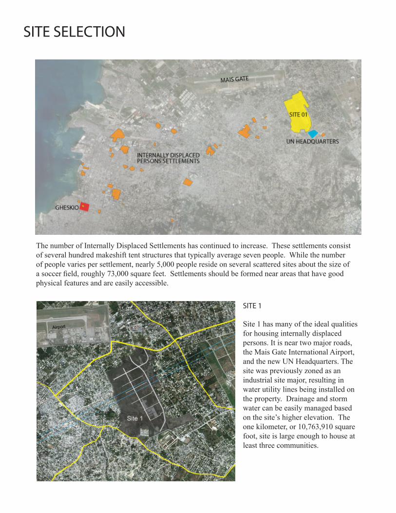
SITE SELECTION
Introduction
Criteria to consider when selecting a site for Haitian refugees revolve around three primary factors regarding the site’s physical features, legal & political conditions and off-site conditions. These criteria are ranked by importance in the table found in the Appendix.
Physical Factors: Soil type, depth to bedrock, water table, slope, elevation, on site water bodies, vegetation, topography, pollution, installed utilities, buildings, fences, bridges, transportation access and the site’s prior history.
Legal and Political Factors: Federal and state regulations, past & current zoning, potential rights-of way, building codes, number and types of neighborhood associations and special interest groups, local community attitudes toward development, transitional community size, location and function of NGO’s and Multilateral Aid groups, food and water distribution, and safety.
Off-Site Factors: Proximity to incompatible land uses (city dump, heavy industry), transportation, community services, and employment centers.
Design connect, DE&ED, and the International Planning Student Organization have come together in response to the January 12, Haitian earthquake. Bringing together a wide variety of backgrounds in architecture, engineering, landscape architecture, and city planning the team has created a design-based response for housing those displaced by the disaster.
The following document explores the ideal qualities that should be considered when:• Selectingasiteforanewcommunitydevelopment• Planninginfrastructurallayoutneedsofsuchasite • Designingconstructiontechniquesthatcanbeusedtomaximizethehealth,safety,andwell
beingofthenewresidents.
This draft is an example of the design services Cornell can offer. The following work should be considered as design suggestions and strategies rather than finalized solutions.

• Construction should be designed and engineered appropriately so as to protect residents from the rain/hurricane season and withstand earthquake aftershocks
• Construction strategies might focus on training, distribution of guidelines, and creation of jobs• Techniques may be chosen to use materials that are readily available such as processed rubble,
concrete masonry units, sand, wire, plastics, fibers, crates, and/or corrugated metal sheets. • Consider stable foundations to prevent flooding and appropriate roof and wall geometries/
reinforcement to minimize hurricane and earthquake damage• Construction methods could be chosen based on cost and time constraints• Transitional shelters may eventually be incorporated into reconstruction• Phasing of construction is a possibility to allow residents to move in as soon as possible. Pre-
fabricated tents can be set up on foundations to provide flood proof shelter. The tent can become a roof as walls are constructed underneath.
CONSTRUCTION STRATEGIES
EXECUTIVE SUMMARY
• Primary and secondary streets should be laid out first to secure access for service, construction, and emergency vehicles.
• Street-side ditches could direct storm water runoff to treatment/infiltration areas in order to prevent flooding and disease.
• Construction support facilities may include rubble processing equipment, training, employment, dormitories, and materials storage
• An infrastructure grid could be laid for water, electricity, and sewer lines (where possible) to core infrastructure units
• Ready-to-build home sites might be laid out on a common foundation surrounding shared core infrastructure units. Previously constructed areas might retain prior parcels for continuity.
• Prime commercial sites along primary roads may be sold to businesses to subsidize low-cost interior home sites and provide additional services and employment.
• Key facilities such as job dispatch and food/fuel distribution centers, security/fire departments, counseling and health clinics could be constructed at primary street intersections. Community facilities (such schools, churches, community centers) could be constructed at secondary street intersections.
INFRASTRUCTURE + LAYOUT
SITE SELECTION
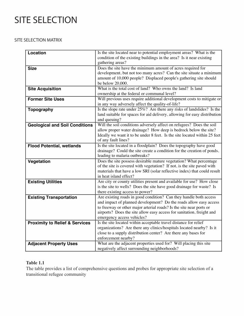
SITE SELECTION MATRIX
Table 1.1The table provides a list of comprehensive questions and probes for appropriate site selection of a transitional refugee community
Location
Is the site located near to potential employment areas? What is the condition of the existing buildings in the area? Is it near existing gathering areas?
Size Does the site have the minimum amount of acres required for development, but not too many acres? Can the site situate a minimum amount of 10,000 people? Displaced people's gathering site should be below 20,000.
Site Acquisition What is the total cost of land? Who owns the land? Is land ownership at the federal or communal level?
Former Site Uses Will previous uses require additional development costs to mitigate or in any way adversely affect the quality-of-life?
Topography Is the slope rate under 25%? Are there any risks of landslides? Is the land suitable for spaces for aid delivery, allowing for easy distribution and queuing?
Geological and Soil Conditions Will the soil conditions adversely affect on refugees? Does the soil allow proper water drainage? How deep is bedrock below the site? Ideally we want it to be under 8 feet. Is the site located within 25 feet of any fault lines?
Flood Potential, wetlands Is the site located in a floodplain? Does the topography have good drainage? Could the site create a condition for the creation of ponds, leading to malaria outbreaks?
Vegetation Does the site possess desirable mature vegetation? What percentage of the site is covered with vegetation? If not, is the site paved with materials that have a low SRI (solar reflective index) that could result in heat island effect?
Existing Utilities Are city or county utilities present and available for use? How close is the site to wells? Does the site have good drainage for waste? Is there existing access to power?
Existing Transportation Are existing roads in good condition? Can they handle both access and impact of planned development? Do the roads allow easy access to freeway or other major arterial roads? Is the site near ports or airports? Does the site allow easy access for sanitation, freight and emergency access vehicles?
Proximity to Relief & Services Is the site located within acceptable travel distance for relief organizations? Are there any clinics/hospitals located nearby? Is it close to a supply distribution center? Are there any bases for enforcement nearby?
Adjacent Property Uses What are the adjacent properties used for? Will placing this site negatively affect surrounding neighborhoods?

SITE SELECTION
Criteria Rank Weight EX: Site 1
Location 3 5 15
Size 2 4 8
Site Acquisition 2 2 4
Former Site Uses 3 2 6
Topography 3 4 12
Soil Conditions 2 2 4
Flood Potential, wetlands 3 4 12
Vegetation 2 2 4
Existing Utilities 3 5 15
Existing Roads 3 5 15
Proximity to Amenities & Services 3 3 9
Adjacent Property Uses 2 2 4
Total Points 108
KEYS
Rank
Weight
Site
Rank the site’s characteristics on a scale of 1-3, 3 being the best.
Assign a weight of importance on a scale of 1-5, 5 being the most important.
Score each site by multiplying the rank by weight for each characteristic. The max is 15 points.
Table 1.2The table shows the results of the matrix analysis of the criteria of Table 1.1
SITE SELECTION
SITE 1
Site 1 has many of the ideal qualities for housing internally displaced persons. It is near two major roads, the Mais Gate International Airport, and the new UN Headquarters. The site was previously zoned as an industrial site major, resulting in water utility lines being installed on the property. Drainage and storm water can be easily managed based on the site’s higher elevation. The one kilometer, or 10,763,910 square foot, site is large enough to house at least three communities.
The number of Internally Displaced Settlements has continued to increase. These settlements consist of several hundred makeshift tent structures that typically average seven people. While the number of people varies per settlement, nearly 5,000 people reside on several scattered sites about the size of a soccer field, roughly 73,000 square feet. Settlements should be formed near areas that have good physical features and are easily accessible.
INFRASTRUCTURE LAYOUT
24 ft x 24 ft
Step 1 GRID used for infrastructural efficiency and adaptability to site conditions.
Step 2 LATRINES accessed from street for efficient and safe waste disposal, and from the inside by residents. TOILETS could be installed once infrastructure is in place.
parcel
latrine/toilet
24 ft x 24 ft
Step 1 GRID used for infrastructural efficiency and adaptability to site conditions.
Step 2 LATRINES accessed from street for efficient and safe waste disposal, and from the inside by residents. TOILETS could be installed once infrastructure is in place.
parcel
latrine/toiletStep 3 PATHS divide parcel into smaller ones and create a predestrian-friendly environment for public activity.
Step 4 PATIO created in the center to provide more space for out-door activities, such as cooking and gathering.
sewage
Step 3 PATHS divide parcel into smaller ones and create a predestrian-friendly environment for public activity.
Step 4 PATIO created in the center to provide more space for out-door activities, such as cooking and gathering.
sewage
Step 5 ROWS created by removing redundant crosswise streets, creating a dense and intimate neighbourhood.
Step 6 LAYOUT provides a possibility for gardens/crops and decentralizes spaces to prevent gang occupations.
Step 5 ROWS created by removing redundant crosswise streets, creating a dense and intimate neighbourhood.
Step 6 LAYOUT provides a possibility for gardens/crops and decentralizes spaces to prevent gang occupations.
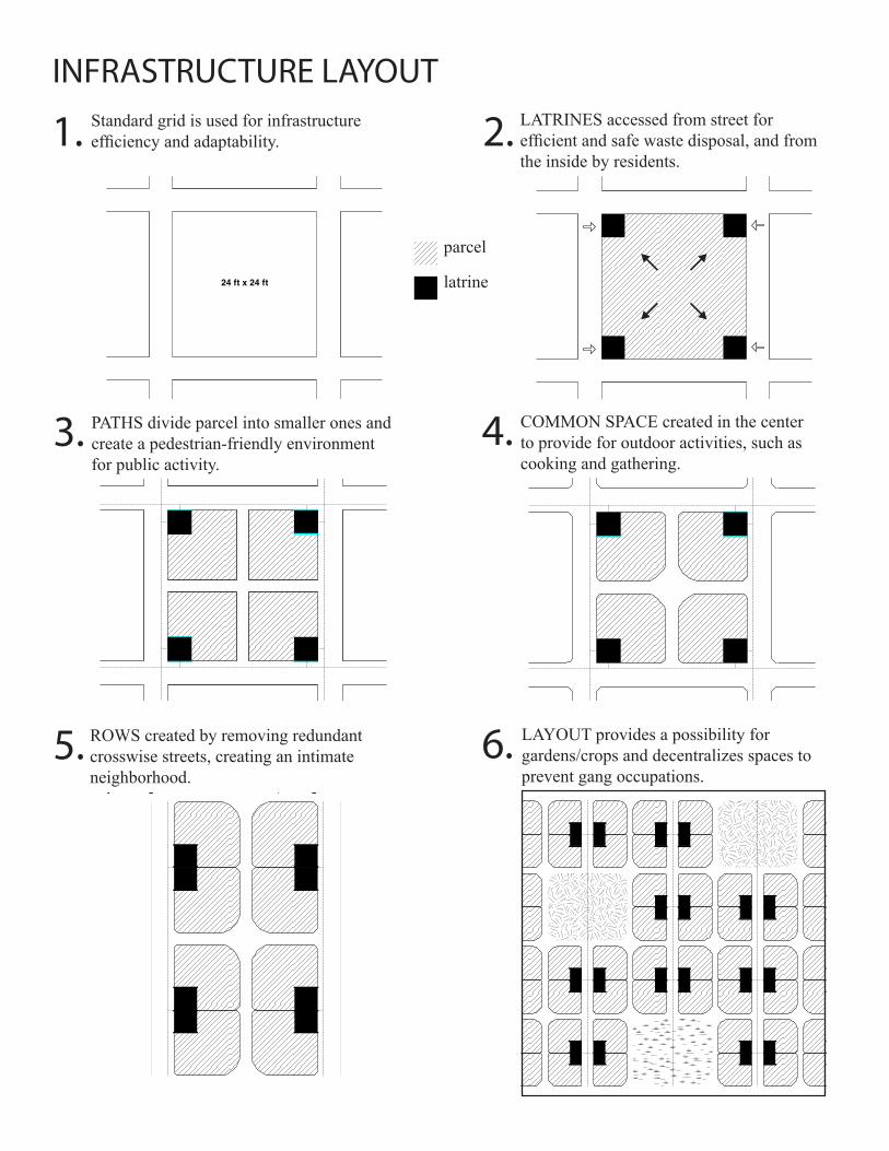
Standard grid is used for infrastructure efficiency and adaptability.
LATRINES accessed from street for efficient and safe waste disposal, and from the inside by residents.
parcel
latrine
PATHS divide parcel into smaller ones and create a pedestrian-friendly environment for public activity.
COMMON SPACE created in the center to provide for outdoor activities, such as cooking and gathering.
ROWS created by removing redundant crosswise streets, creating an intimate neighborhood.
LAYOUT provides a possibility for gardens/crops and decentralizes spaces to prevent gang occupations.
24 ft x 24 ft
Step 1 GRID used for infrastructural efficiency and adaptability to site conditions.
Step 2 LATRINES accessed from street for efficient and safe waste disposal, and from the inside by residents. TOILETS could be installed once infrastructure is in place.
parcel
latrine/toilet
1. 2.
3.
5.
4.
6.
INFRASTRUCTURE LAYOUT
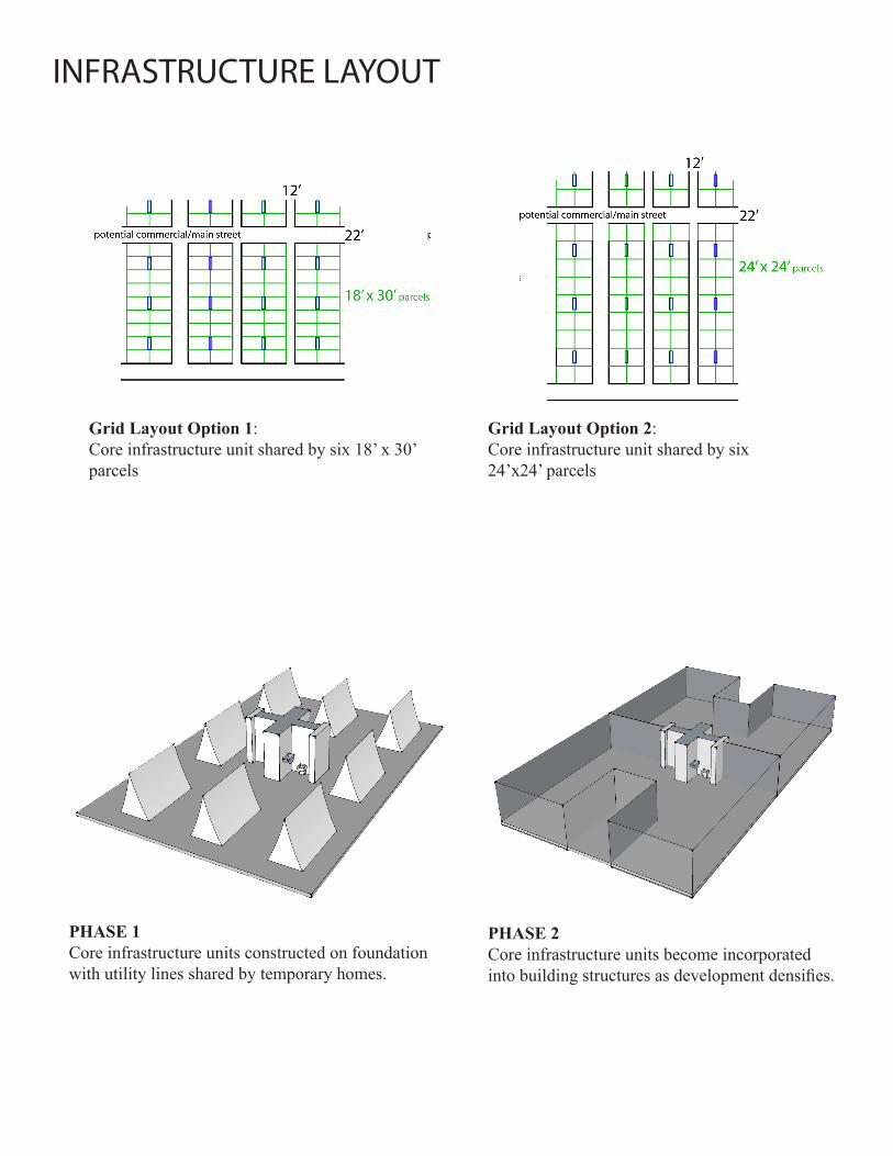
PHASE 1Core infrastructure units constructed on foundation with utility lines shared by temporary homes.
PHASE 2Core infrastructure units become incorporated into building structures as development densifies.
Grid Layout Option 1:Core infrastructure unit shared by six 18’ x 30’ parcels
Grid Layout Option 2:Core infrastructure unit shared by six 24’x24’ parcels

INFRASTRUCTURE LAYOUTPHASE
1
PHASE 1
PHASE 2
PHASE 2
PHASE 3
PHASE 3
In the following illustrations, we are diagramming a suggested phasing process for the establishment of transitional housing communities.
Phase 1, residents establish temporaryshelters in addition to a stagingfacility providing necessities such as: Food,Water,MedicalAid,Security,andConstructionMaterials. Primary and secondaryutilitylines (electric, water, sewer) will be laid followed by mainaccessroads.
Phase 2, residents will begin setting the base foundation for their transitional homes. Additionally, secondaryroads will be laid and drainage will be incorporated to prevent flooding and health problems.
Phase 3, residents will move shelters onto base foundations and begin construction of their transitionalhomes. Homes will be organized into units that will share a commonutilitiesaccess point for washing, cooking, and waste management.
Once the first residents are housed, more residents will arrive and repeatphases1-3. Current residents who have learned the building techniques will assist in guiding new residents through the 3 phases.
Acommunityisfosteredthroughhavingresidentsguideoneanother.
“CreateaCommunity,ThroughBuildingaCommunity”
Staging Facility
Main Access RoadsTemporary Shelters
Main Utility Line (under road)
Utility Lines
Transitional Housing Share Utility Access
New Residents
Secondary Roads
Secondary Roads
Structural Foundation
Structural Foundation
Shelters Transferred back on to Foundation
Shelters Transferred back to Foundation
INFRASTRUCTURE LAYOUTPHASE
1
PHASE 2
PHASE 3
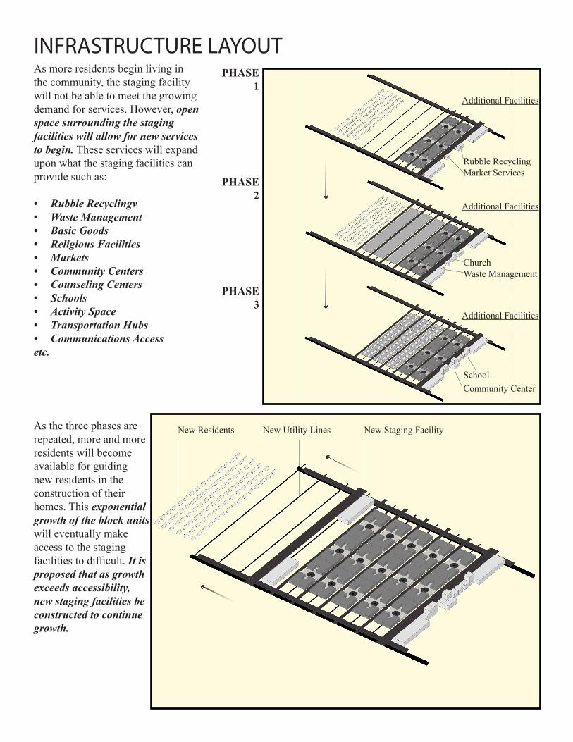
As more residents begin living in the community, the staging facility will not be able to meet the growing demand for services. However, openspacesurroundingthestagingfacilitieswillallowfornewservicestobegin. These services will expand upon what the staging facilities can provide such as:
• RubbleRecyclingv• WasteManagement• BasicGoods• ReligiousFacilities• Markets• CommunityCenters• CounselingCenters• Schools• ActivitySpace• TransportationHubs• CommunicationsAccessetc.
As the three phases are repeated, more and more residents will become available for guiding new residents in the construction of their homes. This exponentialgrowthoftheblockunits will eventually make access to the staging facilities to difficult. Itisproposedthatasgrowthexceedsaccessibility,newstagingfacilitiesbeconstructedtocontinuegrowth.
Rubble RecyclingMarket Services
ChurchWaste Management
SchoolCommunity Center
New Staging FacilityNew Utility LinesNew Residents
Additional Facilities
Additional Facilities
Additional Facilities
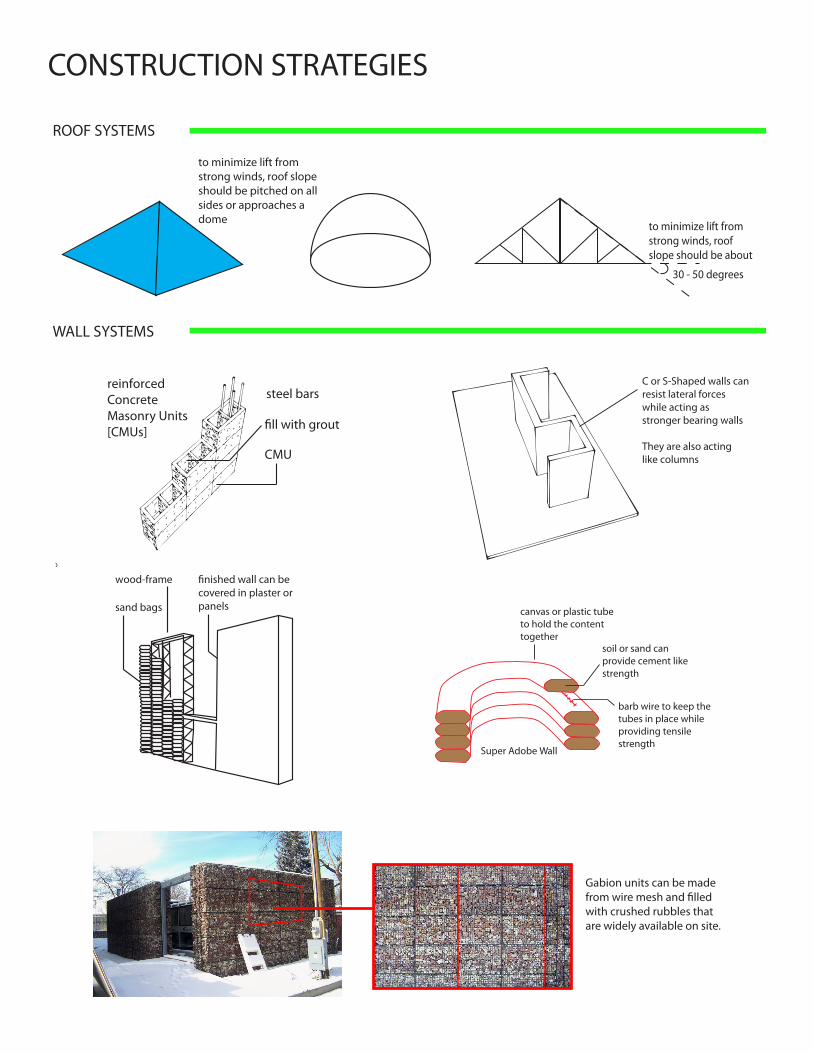
to minimize lift from strong winds, roof slope should be pitched on all sides or approaches a dome
30 - 50 degrees
to minimize lift from strong winds, roof slope should be about
reinforcedConcreteMasonry Units[CMUs]
steel bars
CMU
C or S-Shaped walls can resist lateral forces
while acting as
stronger bearing walls
They are also acting like columns
wood-frame
sand bags canvas or plastic tube to hold the content together
soil or sand can provide cement like strength
barb wire to keep the tubes in place while
providing tensile
strengthSuper Adobe Wall
CONSTRUCTION STRATEGIES
ROOF SYSTEMS
WALL SYSTEMS
Gabion units can be made from wire mesh and filled with crushed rubbles that are widely available on site.
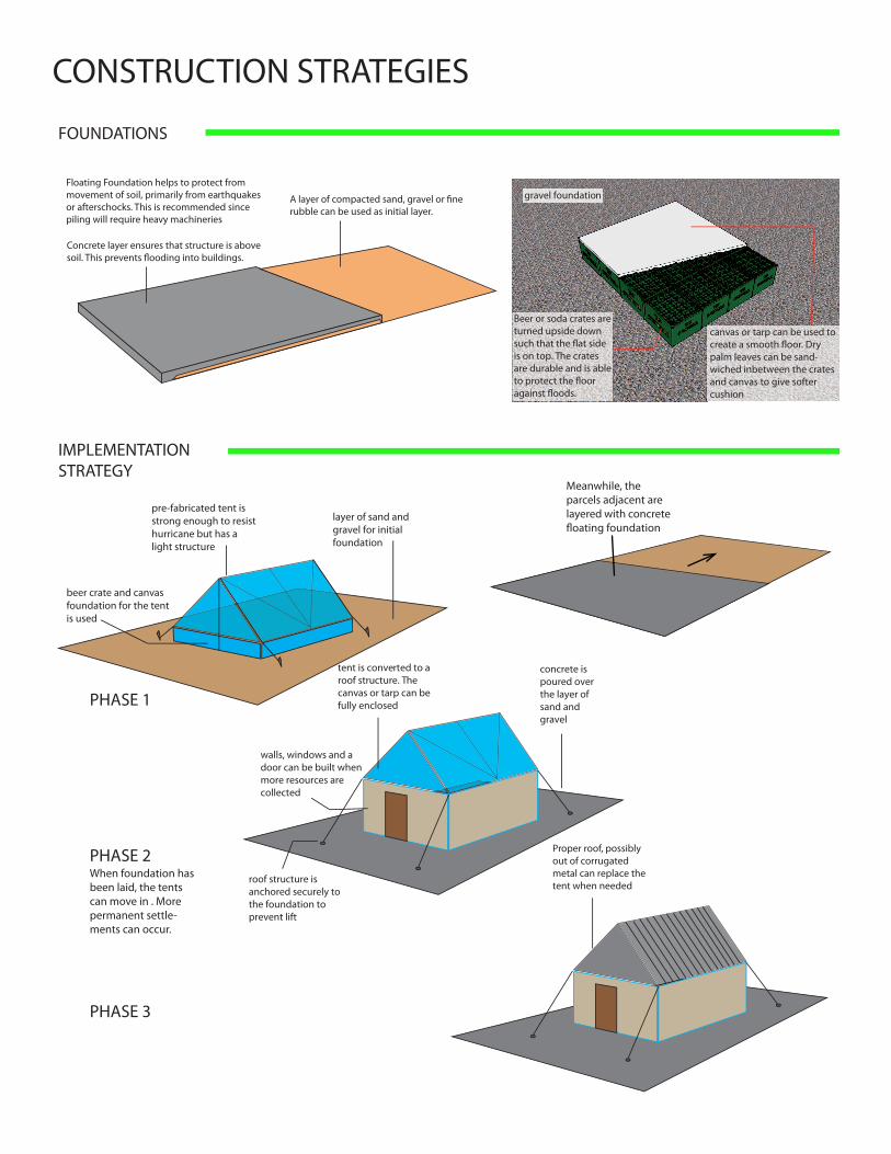
gravel foundation
Beer or soda crates are turned upside down
is on top. The crates are durable and is able
canvas or tarp can be used to
palm leaves can be sand-wiched inbetween the crates and canvas to give softer cushion
pre-fabricated tent is strong enough to resist hurricane but has a light structure
beer crate and canvas foundation for the tent is used
layer of sand and gravel for initial foundation
tent is converted to a roof structure. The canvas or tarp can be fully enclosed
walls, windows and a door can be built when more resources are collected
roof structure is anchored securely to the foundation to prevent lift
concrete is poured over the layer of sand and gravel
Proper roof, possibly out of corrugated metal can replace the tent when needed
CONSTRUCTION STRATEGIES
FOUNDATIONS
IMPLEMENTATIONSTRATEGY
PHASE 1
PHASE 2
PHASE 3
Floating Foundation helps to protect from movement of soil, primarily from earthquakes or afterschocks. This is recommended since piling will require heavy machineries
Meanwhile, the parcels adjacent are layered with concrete floating foundation
When foundation has been laid, the tents can move in . More permanent settle-ments can occur.

• What are the necessary utility lines?• Which facilities can be shared, and which should be private?• How will public transportation serve these communities?• What are the standard dimensions for parcel area, street widths, etc?• How can you ensure that the proper infrastructure is in place before homes are constructed?• Can the infrastructure be upgraded later?• Which services/facilities are prioritized first?• How can infrastructure development pay for itself?
• What have other organizations done? What are their failures and successes?• How can the structural instability of remaining structures be assessed and explained to tenants/
owners?• What is the availability of labor and skills for construction?• What materials are readily available for construction?• What alternative materials (such as bamboo or palm husks) are feasible?• Are the CMU production plants still operable? If so, what is their supply capacity?• How can materials be secured on site during construction?• What are the cost and time constraints?• Should on-site electrical generation or water collection/purification be considered?• How can guidelines be implemented/distributed which ensure safe reconstruction?
• How much open space is there in or on the outskirts of Port au Prince? Who are the owners or stakeholders?• Are there any large hazardous areas in the metro area? (For example, large bodies of stagnant water, abandoned industrial sites, burning trash dumps, etc)• After the earthquake, will there be centralized city services or should newly built communities plan on finding their own utilities?• How functional is sub-national governance from municipal or public agencies?• Are Haitians looking to move into their old neighborhoods, into their current displaced person camps, or into new housing facilities?• What kinds of emergency/temporary housing are being created at present?• What are the systems of coordination between government, aid agencies, and local leaders in relocating and/or building housing?
KEY QUESTIONS
SITE SELECTION
INFRASTRUCTURE + LAYOUT
CONSTRUCTION STRATEGIES
D+E|E+D
The following students were involved in this work:Alix Gerber, Dimitri Siavelis, Andres Mandoza, Borden Edgerton, Gwendolyn Ellman, Joseph Bonk, Garret Halbach, Kim Wilczak, Barry Beagen, Chris Horton, Andrew Beele, Jonathan Leape, Katie Bobroske, Juliana Fulton, Naomi Drucker, Carolina Acevedo, Laura Huacvja, Carl Hansen, Josh Yost, Alan Huang, Bim Krumhansl, Rachel Kunreuther, Declan Keane, Allie Gardiner, Andrew Buck, Karim Mourra, Frantz Seide, Reggie Severe
Cornell’s Design and Planning Club is an interdisciplinary academic collective aiming to bring together students and faculty from various disciplines of Architecture, Planning, Landscape Architecture, Art, Interior Design, Engineering, Design and Environmental Analysis, Real Estate and beyond.
D+E|E+D is an multi-disciplinary independent student organization made of designers, engineers, planners and activists that dedicates projects towards social change and sustainabilty.
The International Planning Student Organization (IPSO) is a graduate student forum for exploring international planning issues. IPSO provides an opportunity to share research ideas, discuss global planning issues, and work on projects addressing the challenges of a changing world.
Design Connect strives to create long lasting partnerships between students and neighboring communities. As an interdisciplinary group, Design Connect students volunteer their time on democratic and sustainable design and planning