Embed Size (px)
Citation preview
1
GRAND BOIS HAITI HOTSPOT OF BIODIVERSITY
FACTSHEET
Morne Grand Bois (1248 m) is an isolated mountain in southwestern Haiti with original forest and a re-markable biodiversity only recently revealed. It is the highest mountain west of Les Anglais in the Départe-ment du Sud, and second highest (after Deux Mam-elles, 1270 m) in all of the Tiburon Peninsula west of a line between Jérémie and Les Anglais. It is unusual in having an elevated, bowl-shaped valley oriented to-wards the west, and in having a large area (195 hect-ares) above 1000 m, with significant tracts of original forest and at least one spring. Accessibility is difficult, and therefore a helicopter was used to conduct bio-logical surveys of the mountain in 2011 and 2013. Sev-eral rare tree species were encountered, including a magnolia species not seen in decades. Of 68 species of vertebrates observed, 4 were new to science (3 frogs, 1 lizard). A frog species of importance, thought to be extinct, was rediscovered. Two of the new frog species are among the smallest in the world. A total of 19 species of frogs were found, one of the largest numbers of co-occurring frog species anywhere in the Caribbean. Several threatened bird species were ob-served. The major threat is deforestation, rapidly en-croaching on the last significant forests. To preserve this unique ecosystem, the Audobon Society of Haiti has established Grand Bois as Haiti’s first private na-ture reserve.
GEOGRAPHY AND PHYSIOGRAPHYGrand Bois is 11.5 km NW Les Anglais, 9.4 km N Grante Pointe, 11.2 km NE Tiburon, 15.1 km E Car-casse, and 3.6 km N Rivière de Tiburon (straight line map distances measured in Google Earth). It is 30 km W of Macaya National Park (Fig. 1). Grand Bois is a bowl-shaped mountain with val-ley and drainage flowing down to the west and a semi-circular ridge (1 km diameter) wrapping around to the east (Figs. 2–3). The highest part of the Main Ridge is in the south (West Peak, 1248 m) and southeast (East Peak, 1234 m), the two peaks being separated by 380 meters.
Grand Bois is unusual, for mountains in this part of Haiti, in having a large area (195 hectares) above 1000 m elevation (75 hectares above 1100 m and 14 hectares above 1200 m). The south face (below Grand Bois West Peak) drops steeply down to the Tiburon River (100 m). Elsewhere, several accessory ridges fan out away from Grand Bois, including a major ridge on the east side (East Ridge), which appears to provide the best access to the upper elevations of Grand Bois by people in nearby communities to the east. A second major entry point is from a valley to the southwest, up the south slope to West Peak and the Main Ridge. A spring is located on East Ridge (Table 1, Fig. 3).
BIOLOGICAL EXPLORATIONWe are not aware of any previous biological ex-ploration of Grand Bois. There are old records of plants, collected by Ekman, from another “Grand-Bois” (in the Massif des Matheux, north-ern Haiti).
A team of biologists from Penn State (PSU) and Société Audubon Haiti (SAH) first visited Grand Bois, Dept. du Sud, by helicopter on 26–27 July 2011, staying one night and making observations and collections. The team included Tiffany Cloud (PSU), Blair Hedges (PSU), Anderson Jean (SAH), and Joel Timyan (SAH), and was accompanied by Miguel Landestoy (field assistant) and Jurgen Hoppe (videographer). We returned by helicop-ter two years later, on 6–8 June, 2013, staying two nights. This second team included Philippe Bayard (SAH), Blair Hedges (PSU), Sarah Han-son (PSU), Jurgen Hoppe, Anderson Jean (SAH), Miguel Landestoy, Jean-Mary Laurent (SAH), and Joel Timyan (SAH). More recently, Jean-Mary Laurent (SAH) and Anderson Jean (SAH) returned to Grand Bois on foot and mule.
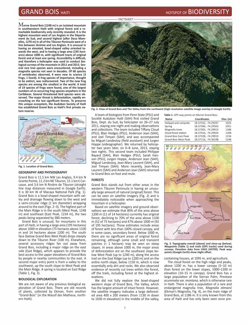
FORESTS Grand Bois stands out from other areas in the western Tiburon Peninsula in having an unusu-ally large amount of natural (original) forest. This can be seen on satellite imagery (Fig. 2) and is immediately noticeable when approaching the mountain in a helicopter.
Based on satellite imagery and ground obser-vations we estimate that 80% of the area above 1200 m (11 of 14 hectares) currently has original forest, declining to 70% of the area above 1100 m (52 of 75 hectares) and 47% above 1000 m (92 of 195 hectares). Those estimates include areas of forest with less than 100% closed canopy, and in some cases, secondary forest. Below 1000 m, there are no significant areas of original forest remaining, although some small and transient patches (< 1 hectare) may be seen on steep slopes. In areas above 1000 m, the major areas of deforestation are on the southeast slope be-low West Peak (up to 1240 m), along the access trail on the East Ridge (up to 1200 m) and on the entire north slope, below 1150 m, which is now essentially only dirt and rocks. We also observed evidence of recently cut trees within the forest, off the trails, including forest at the highest el-evations.
We did not fully explore the bowl-shaped western slope of Grand Bois, The Valley, which has the largest amount of intact forest. However, the satellite imagery indicates a large deforest-ed area 400 x 200 meters (from 1130 m down to 1030 m elevation) in the middle of the valley,
containing houses, at 1095 m, and agriculture. The cloud forest on the high ridge and peaks,
above 1200 m, has a lower canopy (5–10 m) than forest on the lower slopes, 1000–1200 m elevation (10–15 m canopy). Grand Bois has a large population of the Sierran Palm, Prestoea acuminata var. montana, which is otherwise rare in Haiti. There is also a population of a rare and endangered magnolia tree, Magnolia ekmanii (Ekman’s Magnolia, Fig. 4), on the main ridge of Grand Bois, at 1186 m. It is only known from this area of Haiti and has only been seen once pre-
Fig. 2. View of Grand Bois and The Valley from the northwest (high-resolution satellite image overlay in Google Earth).
Fig. 1. Location of Grand Bois.
Table 1. GPS way points on Morne Grand Bois.Name Coordinates Elev. (m)Helipad and campsite 18.37332, -74.29297 1025Spring 18.37396, -74.29503 1051Magnolia trees 18.37305, -74.29913 1186Cloud forest station 18.37416, -74.29924 1208Grand Bois East Peak 18.37328, -74.29919 1234Grand Bois West Peak 18.37116, -74.30198 1248
Fig. 3. Topography overall (above) and close-up (below). Waypoints (Table 1) and trails (GPS tracks) used during surveys. Elevation data from USGS (ASTER). Peak way-points (Google Earth) show slight offset.
GRAND BOIS HAITI HOTSPOT OF BIODIVERSITY
FACTSHEET
2
viously, on Morne Mansinte in 1985, since the types (from an imprecise locality) were collected in 1928. We did not see this tree on Morne Man-sinte in June, 2013, and therefore Grand Bois may have the last remaining population of the species.
Two rare species of small trees belonging to the melastome family were found, both endemic to the south island of Hispaniola and eastern Cuba: Mecranium tuberculatum and Miconia subcompressa. An additional melastome shrub, Sagraea polycheate (Fig. 4), endemic to the Mas-sif de la Hotte and not collected since Ekman first collected it in 1928, was also found.
ANIMALSWe observed and identified 68 total species of
destruction. The other 15 frog species found on Grand Bois are: Eleutherodactylus amadeus (CR), E. apostates (CR), E. audanti (VU), E. bre-virostris (CR), E. counouspeus (EN), E. eunaster (CR), E. glandulifer (VU), E. glaphycompus (EN), E. inoptatus (LC), E. nortoni (CR), E. oxyrhyncus (CR), E. paulsoni (CR), Hypsiboas heilprini (VU), Osteopilus dominicensis (LC), and O. vastus (VU).
We encountered 10 species of lizards and two of snakes on Grand Bois. We believe that one of the lizards (genus Anolis) is a new species, known only from Grand Bois, but the systematic work has not yet been completed. The other nine lizard species that we observed are: Anolis coelestinus, A. cybotes, A. distichus, A. dolicho-cephalus, A. monticola, A. ricordii, A. rupinae, Ce-lestus costatus, and C. stenurus. The discovery of Anolis rupinae (Fig. 6) is a rare species previously known only from four other localities. Two of the other species, A. dolichocephalus (Fig. 6) and A. monticola, are also endemics to the Massif de La Hotte. The two snake species that were observed are both endemic to Hispaniola: Hypsirhynchus parvifrons and Uromacer catesbyi.
Thirty-six species of birds have been observed during these visits to Grand Bois: Anthracotho-rax dominicus, Buteo jamaicensis, Calyptophilus tertius, Catharthes aura, Chlorostilbon swainso-nii, Coccyzus longirostris, Coereba flaveola, Con-topus hispaniolensis, Dulus dominicus, Eleania fallax, Euphonia musica, Falco sparverius, Icterus dominicensis, Loxigilla violacea, Melanerpes stri-atus, Mellisuga minima, Myadestes genibarbis, Nesoctites micromegas, Patagioenas squamosa, Phaenicophilus poliocephalus, Priotelus rosei-gaster, Progene dominicensis, Quiscalus niger, Setophaga caerulescens, S. ruticilla, Spindalis dominicensis, Tachycineta euchrysea, Tiaris bi-color, T. olivacea, Todus angustirostris, T. subula-tus, Turdus plumbeus, Tyto alba, Vireo altiloquus, Xenoligea montana and Zenaida macroura. Of those, two endemic Hispaniolan species are IUCN Vulnerable (VU) status: the Western Chat Tanager (C. tertius) and the White-winged War-
bler (X. montana). Two other endemic Hispan-iolan birds are Near Threatened (NT) status: the Grey-crowned Palm-tanager (P. poliocephalus) and the Hispaniolan Trogon (P. roseigaster, Fig. 7). The Golden Swallow (T. euchrysea) is an IUCN VU species that is found on only on Hispaniola since it has likely been extirpated on Jamaica. Grand Bois is a new location for these rare birds, which have very little habitat left elsewhere. Only one bat species has been observed so far—the Jamaican Fruit Bat (Artibeus jamaicensis). It is fairly common and plays an important role in seed dispersal of the native tree and shrub spe-cies found in Grand Bois.
ECOSYSTEM THREATS
Special thanks: Philippe Bayard, Société Audubon Haitï.Sponsors: U.S. National Science Foundation (DBI-0918891) and Critical Ecosystem Partnership Fund (62132, 63241). Authors: S. Blair Hedges (Temple University, Caribnature) and Joel C. Timyan (Société Audubon Haitï).Publisher: Caribnature © 2014, 2015. Citation: Hedges SB, Timyan JC. 2014. Grand Bois, Haiti. Hotspot of biodiversity. Factsheet. Caribnature (http://www.caribnature.org).
Fig. 7. Endemic bird, Hispaniolan Trogon [E Fernandez].
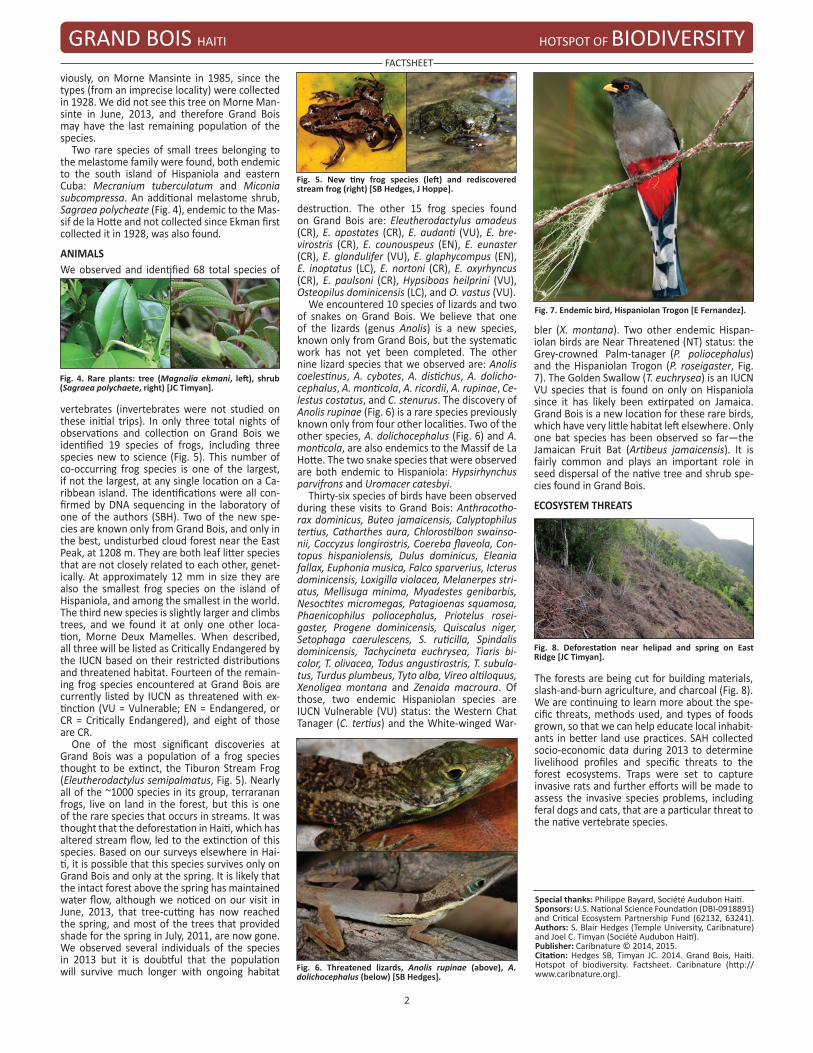
The forests are being cut for building materials, slash-and-burn agriculture, and charcoal (Fig. 8). We are continuing to learn more about the spe-cific threats, methods used, and types of foods grown, so that we can help educate local inhabit-ants in better land use practices. SAH collected socio-economic data during 2013 to determine livelihood profiles and specific threats to the forest ecosystems. Traps were set to capture invasive rats and further efforts will be made to assess the invasive species problems, including feral dogs and cats, that are a particular threat to the native vertebrate species.
vertebrates (invertebrates were not studied on these initial trips). In only three total nights of observations and collection on Grand Bois we identified 19 species of frogs, including three species new to science (Fig. 5). This number of co-occurring frog species is one of the largest, if not the largest, at any single location on a Ca-ribbean island. The identifications were all con-firmed by DNA sequencing in the laboratory of one of the authors (SBH). Two of the new spe-cies are known only from Grand Bois, and only in the best, undisturbed cloud forest near the East Peak, at 1208 m. They are both leaf litter species that are not closely related to each other, genet-ically. At approximately 12 mm in size they are also the smallest frog species on the island of Hispaniola, and among the smallest in the world. The third new species is slightly larger and climbs trees, and we found it at only one other loca-tion, Morne Deux Mamelles. When described, all three will be listed as Critically Endangered by the IUCN based on their restricted distributions and threatened habitat. Fourteen of the remain-ing frog species encountered at Grand Bois are currently listed by IUCN as threatened with ex-tinction (VU = Vulnerable; EN = Endangered, or CR = Critically Endangered), and eight of those are CR.
One of the most significant discoveries at Grand Bois was a population of a frog species thought to be extinct, the Tiburon Stream Frog (Eleutherodactylus semipalmatus, Fig. 5). Nearly all of the ~1000 species in its group, terraranan frogs, live on land in the forest, but this is one of the rare species that occurs in streams. It was thought that the deforestation in Haiti, which has altered stream flow, led to the extinction of this species. Based on our surveys elsewhere in Hai-ti, it is possible that this species survives only on Grand Bois and only at the spring. It is likely that the intact forest above the spring has maintained water flow, although we noticed on our visit in June, 2013, that tree-cutting has now reached the spring, and most of the trees that provided shade for the spring in July, 2011, are now gone. We observed several individuals of the species in 2013 but it is doubtful that the population will survive much longer with ongoing habitat
Fig. 8. Deforestation near helipad and spring on East Ridge [JC Timyan].
Fig. 6. Threatened lizards, Anolis rupinae (above), A. dolichocephalus (below) [SB Hedges].
Fig. 5. New tiny frog species (left) and rediscovered stream frog (right) [SB Hedges, J Hoppe].
Fig. 4. Rare plants: tree (Magnolia ekmani, left), shrub (Sagraea polychaete, right) [JC Timyan].