Embed Size (px)
Citation preview
THE ASSOCIATION
OF
KEN W.BALEY
MA
NITOBA LAND SURVEY
ORS
M E M B E R
331 - 28WPM
32 - 28WPM 2
2 - 28WPM 12 - 28WPM
361 - 28WPM
321 - 28WPM
42 - 28WPM
15m. R/WPlan 52896 BLTO
15m
. R/W
Pla
n 52
896
BLT
O
15m. R/WOperator: Legacy
Legacy 9-32Battery Site
Legacy9-32
Flat
Cropland
Flat
Pasture
Flat
Cropland
EOG 4-1Battery Site
Abnd.13-33
618555 Sask 4-4(B/H 7-5)
EOG 6-4(B/H 9-4)
5m. R
/WO
pera
tor:
EO
GRoad Plan 20BOIS.DIV. - BLTO
Road Plan 20BOIS.DIV. - BLTO
20m
. MTS
Cav
eat
No.
111
5322
/2
12.19m. MTS CaveatNo. 63279BO/2
Fd. 0.025Sq. I.B.
Fd. 0.025Sq. I.B.
Fd. 0.025Sq. I.B.
Sq. I.B.Sq. I.B.
Sq. I.B.Sq. I.B.
Sq. I.B.
Fd. 0.025Sq. I.B.
Buried Telecom(MTS) in Vicinity
Buried Telecom(MTS) in Vicinity
AZ = 91°24'45"804.880
AZ = 1°34'15"
807.
953
AZ = 1°36'50"
846.
153
AZ = 1°32'45"194.105
AZ = 1°32'45"
612.
808
Fd. 0.025Sq. I.B.
EOG 14-33(B/H 16-33)
5m. R/WOperator: EOG
804.802AZ = 91°26'50"
730.930AZ = 91°27'10"
Legacy 2-4(B/H 4-4)
5m. R/WOperator: EOG
20m
. MTS
Cav
eat
No.
111
5674
/2
20m. MTS CaveatNo. 1115674/2 5m
. R/W
Ope
rato
r: E
OG
Buried Telecom(MTS) in Vicinity (x2)
Overhead Power LineOperator: MB Hydro
PPPP
PP
PP
Buried Telecom(MTS) in Vicinity (x2)
Overhead Power LineOperator: MB Hydro
20m
. MTS
Cav
eat
No.
111
5323
/2
EOG 8-4(B/H 7-3)
5m. R/WOperator: EOG
15m. R/WOperator: EOG
EOGRiser Site
20m
. R/W
Ope
rato
r: EO
G
Operator: Legacy
Ope
rato
r: Le
gacy
Parcel APlan 36266 BLTO
AZ = 91°27'40"680.308
6
34
57 8
126
3
57 8
126
34
58
6
34
5
11
14
10
15 16
91112
13 14
Government Road (6N) AllowanceMedium Grade Gravel Road
Twp. 2
Twp. 1Government Road (6N) Allowance
Medium Grade Gravel RoadGovernment Road (6N) Allowance Medium Grade Gravel Road
Government Road (6N) AllowanceMedium Grade Gravel Road
Government Road (6N) AllowanceMedium Grade Gravel Road
Government Road (6N) AllowanceMedium Grade Gravel Road
Gov
ernm
ent R
oad
(165
W) A
llow
ance
Gov
ernm
ent R
oad
(166
W) A
llow
ance
Gov
ernm
ent R
oad
(163
W) A
llow
ance
Med
ium
Gra
de G
rave
l Roa
dG
over
nmen
t Roa
d (1
63W
) Allo
wan
ceM
ediu
m G
rade
Gra
vel R
oad
350°18'50"197.89 (Tie Line)
91°32'45"38.54
30.175(calc.)
85.4691°32'45"
14.28
61°27'1
5"
14.2
831°27'05"
1°27'10"
593.
42
120.0291°37'25" 138.40
91°37'25"
26.29
62°48'4
0"
48.1
034°00'00"
35.09
62°42'1
5"
94.6191°24'20"
91°11'00"
73°49'10"
311.70
91°33'55"200.00 91°33'55"
646.63121°33'45"
23.90
151°33'45"25.00
256.
50181°27'40"
20.00181°27'40"
(calc.)
309.93
(B/H 3-2)
20m. R/WOperator: EOG
20m
. R/W
Opera
tor:
EOG
Overhead Power LineOperator: MB Hydro
20m
. R/W
Ope
rato
r: E
OG
20m
. R/W
Ope
rato
r: E
OG
Fd. 0.025Fd. 0.025
Sq. I.B.Fd. 0.025Sq. I.B.
Fd. 0.025
837.221AZ = 91°23'45" 805.075
AZ = 91°23'45"
20m
. MTS
Cav
eat
No.
113
6596
/2
20m
. MTS
Cav
eat
No.
113
6596
/2
C. of T. 2318595/2Owner: D.C. Gardiner Ltd.
N.E. 1/4 Sec.32-1-28WPMAREA REQUIRED FOR R/W:
Within Battery Site 9-32 = 0.077 ha. (0.19 ac.)Without Above = 0.000 ha. (0.00 ac.)
Total = 0.077 ha. (0.19 ac.)
N.W. 1/4 Sec.33-1-28WPMAREA REQUIRED FOR R/W:
= 1.387 ha. (3.43 ac.)AREA REQUIRED FOR TEMPORARY WORKSPACE:
= 0.377 ha. (0.93 ac.)
194.
105
AZ = 1°32'45"Legacy 9-32
Battery Site
Legacy9-32
MTSPedistal
PP
PP
12.19m. MTS CaveatNo. 63279BO/2
Bur
ied
Tele
com
(MTS
) in
Vic
inity
612.
808
AZ = 1°32'45"
593.
421°27'10"
20.00m.R/W
Win
dorw
20.0
0m.
R/W
Gov
ernm
ent R
oad
(166
W) A
llow
ance
Med
ium
Gra
de G
rave
l Roa
d Low Area(Dry)
X1
X2
X3
CAUTION !
Power Line(Ht=± m.)PP
PP
PP
PP
Overhead Power LineOperator: MB Hydro
7.5x20m. Temp.Workspace
7.5x20m. Temp.Workspace
20.00m.R/W
Low Area(Dry)
Low Area(Dry)
Fd. 0.025Sq. I.B.
Gov
ernm
ent R
oad
(166
W) A
llow
ance
Med
ium
Gra
de G
rave
l Roa
dM
ediu
m G
rade
Gra
vel R
oad
Flat
Pasture
103.983AZ = 91°27'10"
PP
1°27'10"593.42
Win
dorw
Fd. 0.025Sq. I.B.
Bush
PP
20.00m.R/W
20m
. MTS
Cav
eat
No.
111
5322
/2
12.19m. MTS CaveatNo. 63279BO/2
Buried Telecom(MTS) in Vicinity
612.
808
AZ = 1°32'45"
730.930AZ = 91°27'10"
Buried Telecom(MTS) in Vicinity
Overhead Power LineOperator: MB Hydro
Government Road (6N) AllowanceMedium Grade Gravel Road
Overhead Power LineOperator: MB Hydro
Gov
ernm
ent R
oad
(166
W) A
llow
ance
Med
ium
Gra
de G
rave
l Roa
d
Buried Telecom(MTS) in Vicinity
20m
. MTS
Cav
eat
No.
111
5674
/2
7.5x20m. Temp.Workspace 7.5x20m. Temp.
Workspace
Government Road (6N) Allowance Medium Grade Gravel Road
S.W. 1/4 Sec.4-2-28WPMAREA REQUIRED FOR R/W:
= 1.478 ha. (3.65 ac.)AREA REQUIRED FOR TEMPORARY WORKSPACE:
= 0.427 ha. (1.06 ac.)
S.E. 1/4 Sec.4-2-28WPMAREA REQUIRED FOR R/W:
Within Well Site 2-4 (B/H 4-4) = 0.130 ha. (0.32 ac.)Without Above = 1.947 ha. (4.81 ac.)
Total = 2.077 ha. (5.13 ac.)
Legacy 2-4(B/H 4-4)
Buried Power C
able
W/H 2-4(B/H 4-4)
Pump JackPad
PowerPanel
SteelBerm
BermTank
BuriedPipe
Stairs
Berm
X3X2X1
X4
X5
X6
X7
30.1
75(c
alc.
)
20.0
0m.
R/W
287.
275
AZ = 1°37'25"
553.
709
AZ = 1°37'25"
287.
275
AZ = 1°37'25"
553.
709
5m. T
emp.
Wor
kspa
ce
7.5m. Temp.
Workspace
7.5m
. Tem
p.W
orks
pace
7.5x20m. Temp.Workspace
7.5x20m. Temp.Workspace
7.5x20m. Temp.Workspace
7.5x20m. Temp.Workspace
20m
. R/W
Ope
rato
r: E
OG
20m
. R/W
Ope
rato
r: E
OG
C. of T. 1688942/2Owner: Llewellyn John George Allen
C. of T. 2478130/2Owner: Michel Glenn McNish
Owner: Donna Jennifer McNish
C. of T. 2478129/2Owner: Robert Brian McNish
Owner: Lorraine Rose McNish
S.W. 1/4 Sec.3-2-28WPMAREA REQUIRED FOR R/W:
= 1.900 ha. (4.69 ac.)
S.E. 1/4 Sec.3-2-28WPMAREA REQUIRED FOR R/W:
Within Well Site 1-3 (B/H 3-2) = 0.281 ha. (0.69 ac.)Without Above = 1.414 ha. (3.49 ac.)
Total = 1.695 ha. (4.18 ac.)AREA REQUIRED FOR TEMPORARY WORKSPACE:
= 0.375 ha. (0.93 ac.)AREA REQUIRED FOR TEMPORARY WORKSPACE:= 0.738 ha. (1.82 ac.)
C. of T. 2141481/2 (Parcel 1)Owner: Robert Brian McNishOwner: Loraine Rose McNish
Overhead Power LineOperator: MB Hydro
Buried Telecom(MTS) in Vicinity
12.19m. MTS CaveatNo. 85-9059/2
30.1
75 G
over
nmen
t Roa
d (1
65W
) Allo
wan
ce
Med
ium
Gra
de G
rave
l Roa
d
PP
Buried Pipe
X9X10
Government Road (6N) Allowance Medium Grade Gravel Road
X13X12X11
X11
X12
X13
X14
X16
X14
X16
X20X19X18X17
91°11'00"
Fd. 0.025
20m
. R/W
Ope
rato
r: E
OG
20m
. R/W
Ope
rato
r: E
OG 840.436
AZ = 91°27'35"
5m. R/WOperator: EOG
618555 Sask 12-36(B/H 10-35)
EOG 11-36(B/H 9-36)
13
12
20m. R/WOperator: EOG
20m
. R/W
Ope
rato
r: E
OG
EOG 14-26
Fd. 0.025
PP
Low Area(Dry)
Low Area(Dry)Low Area
(Dry)
PPPP
7.5x20m. Temp.Workspace
7.5x20m. Temp.Workspace
CAUTION !
Power Line(Ht=± m.)
20.0
0m.
R/W
Fd. 0.025Sq. I.B.
AZ = 1°33'55"
AZ = 1°33'55"
544.
420
291.
327
S.W. 1/4 Sec.1-2-28WPMAREA REQUIRED FOR R/W:
= 1.751 ha. (4.33 ac.)AREA REQUIRED FOR TEMPORARY WORKSPACE:
= 0.473 ha. (1.17 ac.)
PP
PP
PP
15m. R/WOperator: EOG
N.W. 1/4 Sec.36-1-28WPMAREA REQUIRED FOR R/W:
Within Riser Site 14-36 = 0.040 ha. (0.10 ac.)Without Above = 0.000 ha. (0.00 ac.)
Total = 0.040 ha. (0.10 ac.)
30.1
7530
.175
30.1
75
30.1
75
30.1
75
30.1
75
30.1
75
30.1
75
30.1
75
30.175
30.17530.175
30.17530.175
30.17530.175Fd. 0.025
30.175
30.1
75
30.175
C. of T. 2446072/2 (Parcel 2)Owner: Arlyn George FletcherOwner: Gloria Jean Fletcher
C. of T. 2008916/2Owner: James Claire ClarkOwner: Patricia Diane Clark
EOG 5-1(B/H 11-2)
Overhead Power LineOperator: MB Hydro(Proposed - Power Poles only)
TIE IN
5m. R
/WO
pera
tor:
EO
G
5m. R/WOperator: EOG
Buried Telecom(MTS) in Vicinity (x2)
C. of T. 2349502/2Owner: Raymond Harvey Clark
Owner: Penny Ann Clark
20m. MTS CaveatNo. 1114932/2
20m
. MTS
Cav
eat
No.
111
4932
/2
5m. R/W
EOG1-2
20m
. R/W
Ope
rato
r: E
OG
20m
. R/W
Ope
rato
r: E
OG
AZ = 91°27'35"806.697
20m
. R/W
Ope
rato
r: E
OG
Buried Telecom(MTS) in Vicinity (x2) Buried Telecom
(MTS) in Vicinity (x2) Buried Telecom(MTS) in Vicinity (x2)
Overhead Power LineOperator: MB Hydro
Buried Telecom(MTS) in Vicinity (x2)
Gov
ernm
ent R
oad
(164
W) A
llow
ance
20m. MTS CaveatNo. 1122907/2
20m
. MTS
Cav
eat
No.
111
5325
/2
20m
. MTS
Cav
eat
No.
111
5324
/2
20m
. MTS
Cav
eat
No.
111
5697
/2
S.E. 1/4 Sec.2-2-28WPMAREA REQUIRED FOR R/W:
= 1.643 ha. (4.06 ac.)AREA REQUIRED FOR TEMPORARY WORKSPACE:
= 0.431 ha. (1.07 ac.)
C. of T. 2071946/2Owner: James Claire ClarkOwner: Patricia Diane Clark
Riser SiteEOG 4-2
20.00m.
R/W
20.0
0m.
R/W
AREA REQUIRED FOR TEMPORARY WORKSPACE:= 0.425 ha. (1.05 ac.)
AZ = 1°38'10"191.687
AZ = 1°38'10"
644.
639
Med
ium
Gra
de G
rave
l Roa
d
96°13'35"60.01
50.0091°38'10"
Legacy 1-3(B/H 3-2)
Overhead Power LineOperator: MB Hydro
Buried Telecom(MTS) in Vicinity
Gov
ernm
ent R
oad
(164
W) A
llow
ance
20m. MTS CaveatNo. 1122907/2
AZ = 1°38'10"
191.
687
AZ = 1°38'10"
644.
639 B
urie
d Te
leco
m(M
TS) i
n V
icin
ity
7.5x20m. Temp.Workspace
7.5x20m. Temp.Workspace
7.5x
20m
. Tem
p.W
orks
pace
20.0
0m.
R/W
20.0
0m.
R/W
840.1291°11'00"
7.5x
20m
. Tem
p.W
orks
pace
30.175
CAUTION !
Power Line(Ht=± m.)
Med
ium
Gra
de G
rave
l Roa
d
X17
X18
X19
X20
30.175
30.175
30.175
30.1
75
DETAIL " "SEE
A
DETAIL " "SEE
B
DETAIL " "SEE
C
DETAIL " "SEE
D
DETAIL " "SEE
E
DETAIL " "SEE
F
DETAIL " "25 m
SCALE - 1:1,000100 5 2015
A
DETAIL " "25 m
SCALE - 1:1,000100 5 2015
BDETAIL " "25 m
SCALE - 1:1,000100 5 2015
C
DETAIL " "25 m
SCALE - 1:1,000100 5 2015
D
DETAIL " "25 m
SCALE - 1:1,000100 5 2015
E
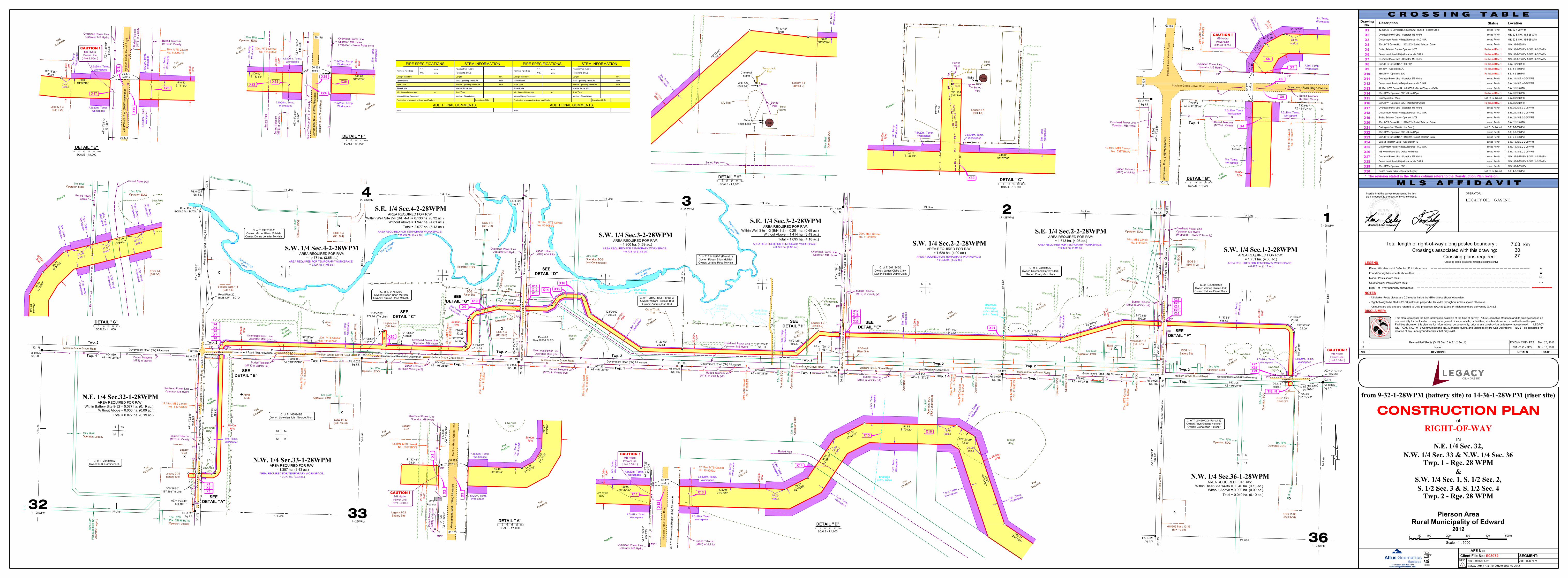
Pierson Area
Twp. 2 - Rge. 28 WPM
2012Rural Municipality of Edward
Twp. 1 - Rge. 28 WPM
N.E. 1/4 Sec. 32,
CONSTRUCTION PLANRIGHT-OF-WAY
IN
of
DATEREVISIONSNO.
N.W. 1/4 Sec. 33 & N.W. 1/4 Sec. 36
from 9-32-1-28WPM (battery site) to 14-36-1-28WPM (riser site)
S.W. 1/4 Sec. 1, S. 1/2 Sec. 2,&
S. 1/2 Sec. 3 & S. 1/2 Sec. 4
Description
X1No. StatusDrawing
X2X3X4X5X6X7
Location
Scale - 1 : 5000
0 50 100 200 300 400 500m
INITIALS
0 Issued CM - TJC - PFS Nov. 15, 2012
1 Revised R/W Route (S.1/2 Sec. 3 & S.1/2 Sec.4) DS/CM - CMF - PFS Dec. 20, 2012
Right - of - Way boundary shown thus:
- Right-of-way to be filed is 20.00 metres in perpendicular width throughout unless shown otherwise.
Total length of right-of-way along posted boundary :Crossings associated with this drawing:
Crossing plans required :
km7.033027
NOTES
DISCLAIMER:
* The revision stated in the Status column refers to the Construction Plan revision.
LEGEND
- Azimuths are grid and are referred to UTM projection, NAD 83 (Zone 14) datum and are derived by G.N.S.S.
Marker Posts shown thus:
Found Survey Monuments shown thus:Mp.
Counter Sunk Posts shown thus: c.s.
- All Marker Posts placed are 0.3 metres inside the GRA unless shown otherwise
This plan represents the best information available at the time of survey. Altus Geomatics Manitoba and its employees take noresponsibility for the location of any underground pipes, conduits, or facilities, whether shown on or omitted from this plan.Facilities shown on this plan are for informational purposes only. prior to any construction on lease or access road, LEGACYOIL + GAS INC. , MTS Communications Inc., Manitoba Hydro, and Manitoba Hydro-Gas Operations MUST be contacted forlocation of any underground facilities that may exist.
I certify that the survey represented by thisplan is correct to the best of my knowledge,
Manitoba Land Surveyor
OPERATOR :
Client File No: SEGMENT: REV.
AFE No:
Survey Date :
File : 158675PL-R1 Job:MEMBER
158675-V
1
LEGACY OIL + GAS INC.
S03072
Placed Wooden Hub / Deflection Point show thus:
PIPE SPECIFICATIONS
Design Standard
Pipe Material
Pipe Type
Pipeline from (LSD):
Pipe Grade
Max. Operating Pressure
Nominal Pipe Size
Internal Protection
Joint Type
kPa.
O.D. mm.
mm.W.T.
Note:
Pipeline to (LSD):
Length km.
Min. Ground Coverage
ADDITIONAL COMMENTSProduction processed at: (gas plant/battery) Location (LSD):
STEM INFORMATION
Normal Operating Pressure kPa.
Material Being Conveyed Method of installation
m.
Altus GeomaticsToll Free: 1-800-465-6233
www.altusgeomaticsmb.com
Manitoba
PP
PP
PP
PP
Gov
ernm
ent R
oad
(163
W) A
llow
ance
Med
ium
Gra
de G
rave
l Roa
d
200.0091°33'55" 646.63
91°33'55"
AZ = 1°33'55"
AZ = 1°33'55"
544.
420
291.
327
Bur
ied
Tele
com
(MTS
) in
Vic
inity
20.0
0m.
R/W
20m. R/WOperator: EOG
20m. MTS CaveatNo. 1114932/2
20.0
0m.
R/W
Bur
ied
Pip
e
Bur
ied
Tele
com
(MTS
) in
Vic
inity
X8X9
X10X11X12X13X14X15X16X17X18X19X20X21X22X23X24
Gently
Rolling
Hayland
Pasture
WindrowWindrow
Windrow
Bush
Abnd.3-4
Windrow
CAUTION !
Power Line(Ht=± m.)
Flat
Cropland
CAUTION !
Power Line(Ht=± m.)
AREA REQUIRED FOR TEMPORARY WORKSPACE:= 0.549 ha. (1.36 ac.)
4
(Not Constructed)
(Not
Con
stru
cted
)
Flat
Cropland
Flat
Cropland
Windrow
Slough(Dry)
Low AreaDry South Edge
of Ravine
Drainage
X15
X15
C/L of TruckTrail
7.5x20m. Temp.Workspace
7.5x20m. Temp.Workspace
Workspace
7.5x20m. Temp.Workspace
Flat
CroplandFlat
Cropland
Flat
Cropland
Flat
Cropland
Windrow Windrow
Low Area(Seasonally
Windrow
Low Area(Dry)
X21
Westman 1-2(B/H 3-1)
Operator: EOG
20m. R/WOperator: EOG
Windrow
Windrow
Windrow
WindrowWindrow
Windrow
Windrow
WindrowWindrow
Windrow
30.175
C. of T. 2590710/2 (Parcel 2)Owner: William Prescott Bird
Owner: Audrey Jane BIrd
12.19m. MTS CaveatNo. 85-9059/2
Buried Telecom(MTS) in Vicinity
Overhead Power LineOperator: MB Hydro
Shrubs Shrubs
South Edgeof Coulee North Edge
of Coulee
X25X26
Overhead Power LineOperator: MB Hydro
X22X23
X24
X25
Overhead Power LineOperator: MB Hydro(Proposed - Power Poles only)
OIL + GAS INC.
GainsboroughCreek
Gainsborough
Creek
Gainsborough
Creek
Gainsborough
Creek
DETAIL " "25 m
SCALE - 1:1,000100 5 2015
F
Low Area(Dry)
Fd. 0.025Sq. I.B.
Flat
Cropland
Flat
Cropland
Flat
Cropland
Flat
Cropland
Flat
Cropland
Flat
Cropland
Manitoba Land Surveyor
7
2 1
20.0
0m.
R/W
30.175(calc.)
30.175(calc.)
PIPE SPECIFICATIONS
Design Standard
Pipe Material
Pipe Type
Pipeline from (LSD):
Pipe Grade
Max. Operating Pressure
Nominal Pipe Size
Internal Protection
Joint Type
kPa.
O.D. mm.
mm.W.T.
Note:
Pipeline to (LSD):
Length km.
Min. Ground Coverage
ADDITIONAL COMMENTSProduction processed at: (gas plant/battery) Location (LSD):
STEM INFORMATION
Normal Operating Pressure kPa.
Material Being Conveyed Method of installation
m.
Twp. 2
Twp. 2
Twp. 1
Twp. 1
Twp. 1
X27
X8
1/4 Line1/4 Line
1/4 Line
1/4 Line
1/4 Line
1/4 Line
1/4 Line
1/4 Line
1/4 Line
1/4 Line
1/4
Line
1/4
Line
1/4
Line
1/4
Line
1/4
Line
1/4
Line
1/4
Line
157.86 (Tie Line)
84°10'50"
AZ = 91°27'40"156.588
Riser Site
30.175
X8X7X6X5X4
Twp. 2
Twp. 1Twp. 2
Twp. 1Twp. 2
Twp. 1
Twp. 2
Twp. 1
840.12
ManmadeDrainage
(±3m. Wide)(±1m. Deep)
Wet)
7.5m
. Tem
p.W
orks
pace
7.5m
. Tem
p.W
orks
pace7.5m
. Temp.
Workspace
15.0
0(c
alc.)
19.75(calc.)
Flat
Cropland(±6m. Wide)
Pasture
MB Hydro
8.20
S.W. 1/4 Sec.2-2-28WPMAREA REQUIRED FOR R/W:
= 1.620 ha. (4.00 ac.)
7.5x20m. Temp.
Med
ium
Gra
de G
rave
l Roa
d
20.00(calc.)
Flat
Cropland
Flat
Pasture
Flat
Cropland
Pasture
MB Hydro
9.00
Flat
Cropland
MB Hydro
7.50
MB Hydro
6.50
MB Hydro
8.10
AZ = 1°37'25"
EOG 1-4(B/H 3-3)
X26
X26X25X24X23X22
X29X28X27
X28X29
Operator: MB HydroOverhead Power Line
216°47'00" 177.96 (Tie Line)
20.0
0m.
R/W
20.00m.R/W
20.0
0m.
R/W
25.00m.
R/W
1°27'10"
40.1
831°27'10"
21.9
6
61°27'1
0"
21.96
91°27'10"701.15
Twp. 2
Twp. 1
20.00(calc.)
7.5m. Tem
p.
Workspace
7.5m. Temp.Workspace
5m. Temp.Workspace
5m. Temp.Workspace
5m. Temp.Workspace
5m. T
emp.
Wor
kspa
ce
91°27'10"701.15
5m. T
emp.
Wor
kspa
ce
5m. T
emp.
Wor
kspa
ce
5m. T
emp.
Wor
kspa
ce
5m. T
emp.
Wor
kspa
ce
5m. T
emp.
Wor
kspa
ce
5m. Temp.Workspace
20.0
0m.
R/W 5m
. Tem
p.W
orks
pace
5m. T
emp.
Wor
kspa
ce
7.5x20m. Temp.Workspace
7.5x20m. Temp.Workspace
1°26'50"
75.0
0
Windrow
102.7191°26'50"
91°26'50"416.86
416.8691°26'50"
5m. T
emp.
Wor
kspa
ce
Slough(Dry)
(calc.)30.175
7.5m. Temp.
Workspace
121°24'20"22.00
95.08
161°24'20"
91°23'45"212.51
124°00'00"308.31
308.31124°00'00"
5m. Temp.
Workspace
15m. R/WOperator: EOG
20.00
(calc.)
20.00
(calc.)
17.55
(calc.)
5m. R/WOperator: EOG
Buried PowerCable
Buried Pipes (x2)
5m. Tem
p.
Workspace
5m. Tem
p.
Workspace7.5m
. Temp.
Workspace
7.5m. Tem
p.
Workspace
DETAIL " "25 m
SCALE - 1:1,000100 5 2015
G
20.00m.
R/W
DETAIL " "SEE
G
EOG 1-4(B/H 3-3)
Low AreaDry
Workspace
37m. Tem
p.
26.2
131°26'45"
30.73
45°54'40"
115.99
75°54'40"
Pasture
122.
261°26'50"
20.00m.
R/W
7.5m. Tem
p.
Workspace
7.5m. Tem
p.
Workspace
Workspace
7.5m. Tem
p.
5m. T
emp.
Wor
kspa
ce
25m
. Tem
p.W
orks
pace
10.01(calc.)
5m. T
emp.
Wor
kspa
ce
5m. T
emp.
Wor
kspa
ce
Tank
Legacy 1-3(B/H 3-2)
Windrow
5m. Temp.
Workspace
5m. T
emp.
Wor
kspa
ce
20.00m.
R/W
W/H 1-3(B/H 3-2)
BuriedPipe Steel
Berm
StairsTruck Load
C/L Trail
ChemicalStand
Pump JackPad
20m
. R/W
Ope
rato
r: E
OG
Buried Pipe
DETAIL " "25 m
SCALE - 1:1,000100 5 2015
H
DETAIL " "SEE
H
96°13'35"60.01
50.0091°38'10"
48°21'25"
156.47
31°26'50"14.28
1°26'50"122.26
61°26'50"14.28
91°37'25"120.02
48°21'25"156.47
Witness
Legacy 1-3
5m. T
emp.
Wor
kspa
ce
RiserRiser
20.00(calc.)
Twp. 2
Flat
Cropland
X30
91°26'50"102.71
X30
91°23'45"581.17
X30
R/W
20.0
0m.