Embed Size (px)
Citation preview

GUIDING BUSINESS ORIENTED VOLUNTEERED GEOGRAPHIC INFORMATION
THROUGH GEOTRIGGER SERVICES:
A CASE STUDY of CROSSFIT AFFILIATES
by
Christie Lauren Root
A Thesis Presented to the FACULTY OF THE USC GRADUATE SCHOOL
UNIVERSITY OF SOUTHERN CALIFORNIA In Partial Fulfillment of the
Requirements for the Degree MASTER OF SCIENCE
(GEOGRAPHIC INFORMATION SCIENCE AND TECHNOLOGY)
August 2015
Copyright 2015 Christie Lauren Root

ii
DEDICATION
In memory of Elizabeth Cruz Snyker. Thank you for teaching me that we never lose our ability
to learn.

iii
ACKNOWLEDGMENTS
To my husband Jay who supported me throughout this endeavor, your simple words of
encouragement never went without notice. To Charlie, words cannot define your unconditional
support and love. Joanne, the only other graduate student who displayed more energy than I did,
thank you for making me laugh every step of the way and for completing this journey with me. I
am also indebted to Tommi, whose knowledge on arrays was critical to my success. To my
advisor Yao-Yi Chiang, thank you for your patience during this process. Finally, I would like to
recognize the remainder of my committee and each faculty member that I have met along the
way.

i
TABLE OF CONTENTS
DEDICATION ................................................................................................................................ ii
ACKNOWLEDGMENTS ............................................................................................................. iii
LIST OF TABLES ......................................................................................................................... iv
LIST OF FIGURES ........................................................................................................................ v
LIST OF ABBREVIATIONS ....................................................................................................... vii
ABSTRACT ................................................................................................................................... ix
CHAPTER 1: INTRODUCTION ................................................................................................... 1
1.1 Motivation ............................................................................................................................. 2
1.2 Application Overview ........................................................................................................... 3
1.3 Choice of Technologies ......................................................................................................... 5
CHAPTER 2: BACKGROUND AND LITERATURE REVIEW ................................................. 7
2.1 CrossFit Affiliates ................................................................................................................. 7
2.2 Volunteered Geographic Information ................................................................................... 8
2.3 Rating Consumer Feedback ................................................................................................ 10
2.3.1 Written Reviews ........................................................................................................... 10
2.3.2 Five-star Ratings ........................................................................................................... 12
2.3.3 Structured Surveys ........................................................................................................ 13
2.4 Esri Geotrigger Services...................................................................................................... 13
2.5 Availability of Similar Resources for CrossFit Reviews .................................................... 14
CHAPTER 3: METHODOLOGY ................................................................................................ 16
3.1 Application Architecture ..................................................................................................... 16
3.2 Process Affiliate Data.......................................................................................................... 17
3.2.1 Data Collection ............................................................................................................. 17
3.2.2 Geocoding of Addresses ............................................................................................... 19
3.3 Establishing Geotriggers ..................................................................................................... 21
3.4 Backend Data Storage and Management ............................................................................ 23
3.5 Application Development ................................................................................................... 24
3.5.1 The Map View .............................................................................................................. 25
3.5.2 Detailed Information View ........................................................................................... 27
3.5.3 Submitting Reviews ...................................................................................................... 28

ii
CHAPTER 4: APPLICATION EVALUATION .......................................................................... 31
4.1 Selecting Evaluators ............................................................................................................ 31
4.2 Evaluation Process .............................................................................................................. 32
4.3 Post-Evaluation Surveys ..................................................................................................... 36
4.3.1 Examination of Survey Questions ................................................................................ 36
4.4 Summary ............................................................................................................................. 47
CHAPTER 5: CONCLUSION ..................................................................................................... 48
5.1 Responding to Project Objectives ....................................................................................... 48
5.2 Future Design Considerations ............................................................................................. 49
5.3 Contribution to VGI ............................................................................................................ 51
5.4 Lessons Learned .................................................................................................................. 51
REFERENCES ............................................................................................................................. 53

iii
LIST OF TABLES
Table 1 Geotrigger parameters. 21
iv

iv
LIST OF FIGURES
Figure 1 CrossFit Affiliate growth from 2001 to 2014. .................................................................. 3
Figure 2 Geographic extents of the study area. ............................................................................... 5
Figure 3 Yelp reviews for CrossFit affiliates. ............................................................................. ..10
Figure 4 Components of development. ......................................................................................... 16
Figure 5 CrossFit website with correct record .............................................................................. 18
Figure 6 Official CrossFit Affiliate Locator Map showing incorrect record ................................ 18
Figure 7 CSV of compiled affiliate business information. ........................................................... 19
Figure 8 CartoDB geocode user interface. .................................................................................... 20
Figure 9 ArcGIS Online CSV export interface. ............................................................................ 20
Figure 10 CSV with geocoding results. ........................................................................................ 21
Figure 11 Esri Geotrigger Editor web interface. ........................................................................... 22
Figure 12 Parse table populated with affiliates data. .................................................................... 23
Figure 13 Authorization to collect location. ................................................................................. 24
Figure 14 Map VC showing standard map and hybrid map. ........................................................ 26
Figure 15 Map VC with affiliate callout box. ............................................................................... 26
Figure 16 Detailed View Controller. ............................................................................................ 27
Figure 17 Review View Controller. .............................................................................................. 28
Figure 18 Offline push-notification. ............................................................................................. 30
Figure 19 Evaluator task list. ........................................................................................................ 32
Figure 20 Apple Maps driving direction. ...................................................................................... 33
Figure 21 Push-notification requesting user feedback. ................................................................ .34
Figure 22 Survey submission conformation. ............................................................................... .35
v

v
Figure 23 Pie chart and percentage table of Question 1 results. ................................................... 37
Figure 24 Bar graph of survey Question 2 results ....................................................................... 38
Figure 25 Bar graph of survey Question 3 results ........................................................................ 39
Figure 26 Bar graph of survey Question 4 results ........................................................................ 40
Figure 27 Bar graph of survey Question 5 results ........................................................................ 42
Figure 28 Bar graph of survey Question 6 results ........................................................................ 43
Figure 29 Bar graph of survey Question 7 results. ....................................................................... 44
Figure 30 Pie chart of survey Question 8 results. ......................................................................... 45
Figure 31 Survey Question 9 list of improvement recommendations .......................................... 46
vi

vi
LIST OF ABBREVIATIONS
AAG Association of American Geographers
API Application Programming Interface
BaaS Backend as a Service
CFHQ CrossFit Headquarters
GDB Geodatabase
GIST Geographic Information Science and Technology
GPS Global Positioning System
IDE Integrated Development Environment
iOS iPhone Operating System
JSON JavaScript Object Notation
LBS Location Based Services
OBJ-C Objective Computing Programming Language
OCALM Official CrossFit Affiliate Locator Map
OEM Original Equipment Manager
OS Operating System
OSX Operating System 10
SaaS Software as a Service
SDK Software Development Kit
SMS Short Messaging Service
SSI Spatial Sciences Institute
URL Uniform Resource Identifier
USC University of Southern California
vii

vii
VC View Controller
VGI Volunteered Geographic Information
WOD Workout Of the Day
viii

viii
ABSTRACT
Customer feedback is a platform to share awareness about a business or service between
consumers and is an excellent resource for gathering information needed to determine if that
businesses or service is satisfying customer requirements. Yet, consumers will often fail to leave
reviews if the process to do so is too lengthy, overly complicated, or if too much time has passed
after visiting a business. Reading numerous reviews often requires consumers to dedicate a
considerable amount time to compose or examine and frequently provide extraneous amounts of
information irrelevant to the business reviewed. Problems also arise from the use of over-
simplified rating scales that lack context and become meaningless when consumers do not know
what attributes scores are based on. The existence of these issues creates the demand for a tool
that can collect, compile, and deliver relevant business reviews back to consumers quickly and in
a user-friendly format.
The tool developed for this study consisted of a mobile application that uses the CrossFit
business model and associated CrossFit affiliate locations as a case study. By using a geotrigger
service, the application prompts users to provide Volunteered Geographic Information (VGI) that
consists of customer feedback, in the form of a brief survey, immediately after visiting an
affiliate location. The application compiles gathered survey scores and then provides them back
to users in near real-time. Evaluation of the mobile application found that it assisted consumers
in making more informed decisions when attempting to select which CrossFit affiliate to
patronize and accomplished its intended purpose of collecting and disseminating of information
obtained in near real-time directly from customer feedback.
ix

1
CHAPTER 1: INTRODUCTION
The incorporation of Location Based Services (LBS) in Geographic Information Systems (GIS)
has been in use for over a decade and extends GIS capabilities and spatial information processing
to end users through the Internet or a wireless network (Koeppel 2000). With an ever-growing
dependency on mobile devices and the constant desire to have these devices within arm’s reach
(Gibson 2011), the extension of spatial services that LBS offers has the potential to reach an
extremely large percentage of the population. This is especially so if we consider that 91% of
American adults own and use cell phones for more than just phone calls (Pew Research Center
2013). For this simple fact, many companies such as Dunkin Donuts (Dunkin Donuts 2011) and
7-Eleven (7-Eleven 2015) employ LBS as a form of mobile marketing in an effort to gain new
clientele or to maintain customer loyalty. Mobile marketing practices include the earning of
consumer loyalty incentives such as, promotional discounts on future purchases, coupons for
current promotions, and special access to advertisements. Consumers may have the ability to use
a check-in feature from their device that reports location based activity information back to
social media websites (e.g., Facebook.com) or directly back to the business employing the
service. Each of these approaches link the consumer to a geo-location that provides information
used to interpret consumer behavior.
Traditionally, LBS technologies work by implementing a function called geofencing that
signals a mobile application to transmit an alert to the device once it has crossed the geographic
boundary of a virtual perimeter referred to as a geofence (Nait-Sidi-Moh, Bakhouya, & Gaber
2013). Examples of alerts can consist of an email, in-app message, or push notification, all of
which promote spontaneous dialog between the application and the user based entirely on the
devices geographic location. On 19 November 2013, Esri publically announced the release of

2
their Geotrigger Service. The service uses geofences like LBS to add location based awareness to
mobile applications by triggering a device to generate push notifications that alert users to an
event or notify a server to execute a custom event (Geoloqi 2013). The Esri Geotrigger Service
places an emphasis on minimizing battery drain, having a flexible Application User Interface
(API) for expanding development of use cases beyond the simple device-to-user alert, and
seamless integration into a variety of platforms, all of which are advancements over previous
geofencing technologies (Esri 2015).
This thesis evaluates the effectiveness of a mobile application utilizing geotriggers as a
method to aid in the collection of business oriented Volunteered Geographic Information (VGI)
in near real-time. Geotriggers act as a prompt for users to submit VGI in the form of consumer
surveys that inquire about CrossFit affiliates (detailed in Chapter 2).
1.1 Motivation
CrossFit is a trademarked name for a corporation and a fitness program that combines
high intensity interval training, Olympic weightlifting, gymnastics, plyometric, and other forms
of exercise. Daily exercises, referred to as the Workout of the Day (WOD), are normally done in
a group class setting concentrated around a core strength and condition program that is a broad
and inclusive style of fitness (Glassman 2002).
The popularity of CrossFit has grown into an international phenomenon since its
inception in 2001. Every month new locations open and as of June 2014 there were over 10,000
registered CrossFit affiliates located throughout the world as shown in Figure 1 (Beers 2014). As
new affiliates continue to open, consumers have an overabundance of choices when it comes to
selecting which location they should patronize. This can easily become a daunting task for
consumers; especially those who are new to the CrossFit community and thus limited in their

3
knowledge as to what key components distinguish one affiliate as a better choice compared to
the next.
Acknowledgement of these challenges necessitates the requirement for a tool that can
help answer consumer questions. The goal of this application is to assist consumers in making
decisions that are more informed by providing them with attribute data on affiliates obtained
directly from consumer feedback. The collection, compilation, and delivery of information
derived directly from customer experiences immediately after they have occurred can
accomplish this. An added benefit is that affiliate owners, if they desire, can also use the
collected information to improve business practices based on input from their primary consumer
group. By guiding business oriented VGI to answer industry specific questions, such as the
quality of the coaching staff or cleanliness of a facility, the application gives users access to
information in a more focused manner as compared to the time it takes to examine numerous
written reviews from resources similar to Yelp (Yelp 2015), Google+ (Google 2015), or
Foursquare (Foursquare 2015).
1.2 Application Overview
The SurveyWOD application built as part of this thesis, hereafter termed “app” runs on
the Apple iPhone Operating System (iOS). The app prompts users to provide requested VGI via
Figure 1 CrossFit Affiliate growth from 2001 to 2014. Source: Beers 2014

4
push-notifications sent directly to the device upon exit from a designated geofence. The
notification invites users to provide feedback on relevant business oriented information in the
form of a short structured survey. Structured survey questions inquire about qualities determined
to of relevance and of value when choosing a CrossFit affiliate.
Less influenced purely by the convenience of proximity, consumers rely more on reviews
as an important factor in deciding which local business they should use (Anderson 2013). This
offers an ideal setting for testing the app in a competitive market and observing how it can be of
considerable value to consumers and business owners alike. Additional functions of the app
allow for users to search nearby affiliates, generate driving directions, view current ratings, and
rapidly identify highly rated locations within close proximity to the devices current location.
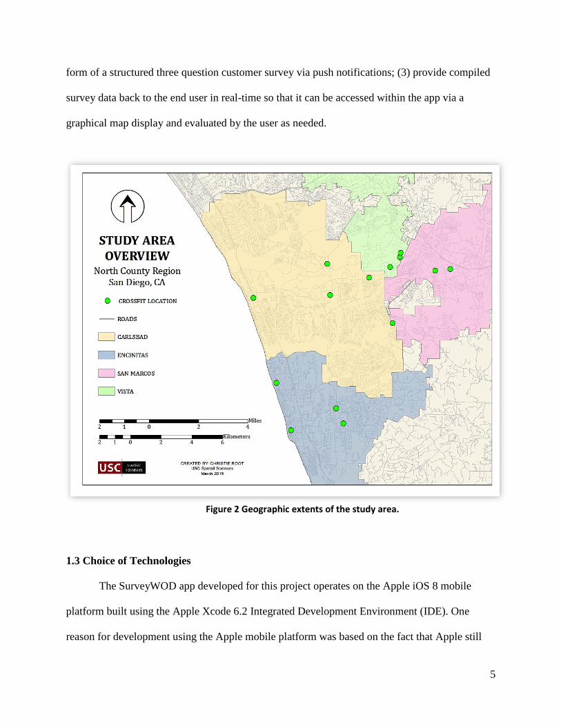
The geographic area covered by the app’s spatial extents is a subset of CrossFit affiliate
data points located in the North County Coastal region of San Diego, California. Cities included
in this region are Encinitas, Carlsbad, San Marcos, and Vista, as seen in Figure 2. The subset of
selected cities represents a relatively small geographic area moderately saturated with affiliates.
For the scope of this project, utilization of a smaller sample size minimizes the time needed to
compile, populate, and manage the affiliate database, but is easily extendable to an unlimited
number of data points as needed. Because the mobile device needs to physically reside at each
affiliate to support field-testing, the distance between furthest points does not exceed more than
twenty-minutes of driving time. Like the sample size, the spatial extents of the app are
expandable and can work over any geographic area.
Project objectives and design considerations for development of the SurveyWOD app
include: (1) design an app that allows users to locate, select, view attribute data, and generate
driving directions for affiliates within a feature database; (2) prompt users to provide VGI in the
5
form of a structured three question customer survey via push notifications; (3) provide compiled
survey data back to the end user in real-time so that it can be accessed within the app via a
graphical map display and evaluated by the user as needed.
1.3 Choice of Technologies
The SurveyWOD app developed for this project operates on the Apple iOS 8 mobile
platform built using the Apple Xcode 6.2 Integrated Development Environment (IDE). One
reason for development using the Apple mobile platform was based on the fact that Apple still
Figure 2 Geographic extents of the study area.
6
holds a large majority of the mobile device market. According to the February 2015 report
published by comScore (2015) Apple ranked as the top Original Equipment Manager (OEM)
producer with 41.7 percent of the U.S. smartphone subscriber population. By developing for this
market of potential users, the opportunity to reach a large target audience increases. In addition,
Xcode 6.2 offers a more superior IDE in terms of its user interface, development flexibility, and
debugging capability that heavily influenced development for Apple.
The app is written in the Objective-C programming language and includes several
programming libraries referred to as dependencies, which integrate existing sources of code from
other developers to quickly incorporate various capabilities. These dependencies include the Esri
Geotrigger Service Software Developer Kit (SDK) (Esri 2015), the Parse SDK, SVProgressHUD
(Veremette 2011), and Apple’s MapKit and CoreLocation Frameworks. The 5-star rating iOS
component entitled RatingView, developed by Hélesbeux (2013) is obtainable through the
GitHub Repository. All incorporated technologies are open source and freely available for use by
the public, which made them an excellent choice for development of this project. The use of the
CocoaPods dependency manager for Objective-C projects, allowed for seamless integration and
update of all app dependencies with minimal effort (CocoaPods 2015).

7
CHAPTER 2: BACKGROUND AND LITERATURE REVIEW
Chapter 2 provides an introduction into CrossFit affiliates and discusses methods and resources
considered during creation of the SurveyWOD app built as a part of this thesis project. Section
2.1 is a brief summary of CrossFit affiliates. Section 2.2 provides an overview of Volunteered
Geographic Information (VGI). Section 2.3 examines various methods for rating consumer
feedback and explains which ones did or did not meet project objectives. Section 2.4 introduces
the basic functionality of Esri Geotrigger Service. Section 2.5 explores similar resources related
to CrossFit currently available to the public
2.1 CrossFit Affiliates
The equipment needed to complete a CrossFit workout can vary greatly, be relatively
expensive to purchase, and require a sizeable amount of space to store. Because of these factors,
CrossFit training typically requires the use of an established affiliate location in order to
complete daily workouts.
Although affiliates carry the CrossFit brand name, locations are individually owned and
operate independently of each other. This results in significant variations between each affiliate
location and in an athlete’s experience. This can become an issue if the services provided are
inadequate or if the goals of the affiliate are not in line with the athletes. Some affiliate locations
choose to concentrate more heavily on one form of fitness over another, such as Olympic lifting
versus gymnastics. Many affiliates aim to create a family orientated environment while others
are extremely competitive and push their athletes to perform at higher and more intense
performance levels. An affiliate’s coaching staff can also vary greatly dependent upon individual
personalities, extent of experience and training, or their ability to motivate and connect with
athletes. Considering this and that the average monthly cost for membership can run anywhere

8
between $150 - $250, consumers should ensure that the affiliate they choose is one that will meet
their fitness goals and provide an enjoyable environment.
Both veterans of CrossFit and novices should recognize some of the key characteristics
that distinguish one location from another. Derived from the right source and implemented
correctly, consumers can use feedback to help identify these characteristics and gauge whether or
not a business will meet their needs. Because we have identified that the purpose of feedback is
to share awareness between consumers (Chapter 1), this makes it an excellent resource for
assembling information needed to determine if a businesses is satisfying consumer requirements.
2.2 Volunteered Geographic Information
VGI harnesses tools to create, assemble, and disseminate geographic data provided
voluntarily by individuals (Goodchild 2007). As consumer feedback is dependent on the
customers willingness to voluntarily provide input on a product or service, VGI is dependent on
human volunteers acting as sensors of the environment to willingly contribute to the creation,
collection, and the dissemination of geographic information. According to Arigos and Mann
(2010) VGI is a specific example of a community-based information collection model that
features content created by end users. In addition, the content collected provides information
from a person’s direct knowledge on a subject, in this case CrossFit, to assist potential
consumers in making decisions.
VGI collected as part of the SurveyWOD app consists solely of information obtained
from users who freely volunteered to give their opinions about CrossFit affiliates. To gather
VGI, users complete a brief in-app survey for specific affiliate that inquires about items relevant
to CrossFit. To ensure the effectiveness of these surveys, evaluation and research of various
forms of consumer rating systems took place.

9
The collection of VGI for this project differs from other VGI based projects that collect
customer feedback in several ways. Mobile applications like TripAdvisor (2015) collect
customer feedback as written reviews or a single overall star rating. Foursquare (2015) collects
reviews for a multitude of business types and only asks users if they liked or disliked a location
and accepts written reviews. Each of these mobile applications utilizes LBS elements such as
geoawareness and geofencing to create location aware applications. Yet, LBS is not used in these
applications to solicit feedback back from users in near real-time.
Expedia (2015) currently uses a service developed by Routehappy to collect near real-
time customer feedback. Routehappy is a differentiation platform designed to rate air travel
comfort, which aggregates collected data and then returns estimated ratings (Routehappy 2015).
On conclusion of a flight segment, a user will receive a notification in the form of an email
requesting input. The notification contains a link to a short survey with questions about their
recent air travel as it relates to comfort. The user rates aspects like seat comfort, inflight
entertainment, and wi-fi by selecting either a happy or a sad face. The trigger to receive these
notifications is based on user flights and is tied to several complex algorithms that Routehappy
refers to as Flightmatch that is linked to an extensive database maintained and updated by
Routehappy known as Flightpad (PRNewswire 2014). Following elements of this model, the
SurveyWOD app asks industry specific questions directly related to one business or category.
This strategy helps to guide users towards submitting explicitly more focused VGI with
increased credibility. In addition, collected VGI is tied to predetermined geographic data points,
which improves the spatial accuracy of collected VGI because the uncertainty over its
geographic origins becomes diminished.

10
2.3 Rating Consumer Feedback
Systems for collecting and rating consumer feedback are two approaches to opening
dialogue between people and the particular service they seek. If done incorrectly and without
forethought, the collection and rating of consumer feedback can have a biased influence and
limited effectiveness. All methods of collecting consumer feedback have advantages and
disadvantages and can generally operate independently or in conjunction with another method.
This section examines three types of review methods commonly used to collect and rate
feedback considered for this project. To meet the objectives of the SurveyWOD app, feedback
method could not require an excessive amount of time to complete or use values that were not
directly attributable to qualities recognized as important to the CrossFit community.
2.3.1 Written Reviews
Several online forums allow users to rate businesses by leaving opinion-based reviews
about their experiences. Yelp.com is one of the more popular examples of this type of resource.
Prospective consumers are able to search by a variety of means such as name, business type, or
physical location. Once searched, consumers can view submitted reviews in order to begin the
process of researching potential businesses. Users leave written feedback along with star rating
however, these reviews do not always accurately reflect the true merit of a business. Consumers
may rate a business poorly if they did not like location of the facility or if they were unable to
find a good parking spot. Negative reviews, which may be completely unrelated to the business,
have a tendency to sway consumer perceptions more than a positive review would. This
produces a negative bias in potential customers based solely on the fact the overall theme of the
review was unfavorable and not based on its actual content (Baumeister et al. 2001).

11
Gideon Lewis-Kraus discusses some of the additional flaws that plague the validity of
reviews posted on websites like Yelp in his May 2013 article in The New Yorker (online edition).
He argues that the practice of businesses acquiring positive reviews by any means possible, i.e.
rewarding reviewers for input, as being problematic. In the case of CrossFit, most Yelp searches
will reveal that nearly every CrossFit affiliate has great reviews and a 5 star rating, which could
be a result of gym members being asked to submit positive feedback on behalf of the affiliate
(Figure 3). Lewis-Krause also states that, “the fact that Yelp makes money by selling ads and
prime placements to the very businesses it lists under ostensibly neutral third-party review” as
another primary problem because it manipulates the consumers perception and undermines the
ratings statistical relevance.
With so much room for external bias in written reviews and the substantial amount of
time needed to read composed assessments, this method failed to satisfy app objectives outlined
Figure 3 Yelp reviews of CrossFit Affiliates.

12
in Section 2.3. This project excluded written reviews entirely and went with the following two
systems of review instead.
2.3.2 Five-star Ratings
A five-star rating system can measure aspects of business performance on a scale of 1 -5
and represent this measurement graphically using star icons. The advantage to this system is its
ability to symbolize average scores so users can easily visualize and assess multiple ratings
quickly. A potential shortfall to this system arises when consumers are unable to determine how
a score is compiled. This occurs when no standard for star rating values exist because an
unknown or unpublished criterion for scoring and ranking is used or made available to the
public. Alternative drawbacks can transpire when used in conjunction with other methods such
as written reviews. Five-star rating averages can detract consumers away from important details
that could be contained within the textual portion a review.
Although star ratings appear arbitrary in nature, they are beneficial and are widely
recognized as one of the most common methods of rating (Carr 2013). They have the ability to
quickly inform consumers because basic inferences can be determined about a business, such as
a five-star rated business will generally yield a better consumer experience as compared to a one-
star rated business (Usman et al. 2010). In addition, a survey system comprised of numerically
valued responses is a decidedly more efficient method for tabulating results swiftly.
Due to simplicity, the ability to quickly illustrate calculated values, and the public's
familiarity with the star rating systems it is integrated in the app. To avoid concerns about what
values are based on or determined, the star rating system and the structured survey are used in
tandem.
13
2.3.3 Structured Surveys
Structured surveys have the advantage of permitting examiners to maintain more control
over the collection of feedback from respondents. This study used a “closed” structured survey,
defined as quantitative approach to collecting user feedback where each question is
predetermined and each participant receives that same survey questions (HistoryLearningSite
2011). In addition to retaining control, another advantage to the closed structured survey is how
it easily combines with other methods of collection such as the five-star rating discussed in
Section 2.2.2. A potential concern is the risk of selecting irrelevant survey questions or survey
questions that only the examiner has determined to be of value. To help mitigate the potential for
irrelevancy two articles, 13 Tips for Choosing a CrossFit Gym (Huntley 2011) and Tips for
Choosing a CrossFit Gym (Jenkins 2015) functioned sources for extracting appropriate survey
questions. Both articles examine various elements that make a successful CrossFit Affiliate and
what potential members should consider before buying a membership.
2.4 Esri Geotrigger Services
The Esri Geotrigger Service works by utilizing a mobile devices built-in Global
Positioning System (GPS) to determine when a device has crossed, either by entering or exiting,
the geographic boundary of an establish geofence (Tengku 2013). This service extends
traditional geofencing technology with the inclusion of a variable tracking profile referred to as
“adaptive.” The adaptive tracking profile automatically adjusts GPS updates to optimize location
accuracy that helps minimize battery drain (Esri 2015). Both complex polygons and point radius
features can represent the geographic extents of a geotrigger. In addition, a developer may create
an unlimited amount of geofences hosted in the cloud whereas only a small number of geofences
can be stored on a device using the Apple native geofencing capability.

14
The crossing of a geofence threshold causes communication between the device and the
geotrigger service to begin. The device first signals the geotrigger service, which in turn prompts
the app to perform an action. This action, referred to as a “trigger,” consists of a condition and an
action, whereas the action informs the service to send a Short Messaging Service (SMS) push
notification (Esri 2015). When attempting to engage consumers in near real-time, the benefit
comes from how SMS notifications immediately start a dialog between the mobile application
and the consumer during the crucial moments that they are engaging in the experience (Estopace
2014). This reduction in engagement time combined with the implementation of a brief,
structured star rated survey, addresses the issues identified in section 1.2 and meets the
application objectives
2.5 Availability of Similar Resources for CrossFit Reviews
The availability of resources related to researching CrossFit affiliates, mobile or web
based, are limited in their scope. Those that do exist typically fall into three separate categories.
The first category is comprised mostly of web based services and a small amount of
mobile applications that only offer functionality such as mapping affiliate locations and
providing basic information that includes phone number, address, website, and driving
directions. These types of resources offer little to no insight on business practices that can alert
users to the quality of the services they provide.
Resources similar to Yelp and Foursquare that provide consumers with an open forum to
submit written reviews along with star-ratings (Yelp 2015) make up the second category. These
sources can often be time consuming to navigate and may not always provide a true reflection of
the reviewed business (Section 2.3.1).

15
The third category consists of applications that allow access to services used by affiliate
owners to manage business aspects of their gym and offer some client features as well. An
example of this is the Wodify application. Wodify delivers business functions such as billing,
membership, sales, and payroll for owners while athletes are able to track workouts, nutrition,
and membership dues (wodify.com 2014). While designed for CrossFit affiliates, athletes can
only use this application and its accompanying features if they are paying members of an affiliate
that utilizes Wodify and maintains an active subscription.
A mobile resource to search and access basic business information combined with the
ability to quickly view consumer ratings based on the qualities deemed relevant for CrossFit
affiliates by the CrossFit community (detailed in Chapter 3) does not exist. The application
developed for this thesis resolves issues by leveraging the advantages of multiple reviewing
methods to provide users with a positive experience and a necessary resource to help in their
decision-making process. Another benefit of the application is that is can also be utilized by
business owners who are seeking related metrics that can help them to improve various aspects
of their business based directly off customer feedback.

16
CHAPTER 3: METHODOLOGY
This chapter examines the design and development of the SurveyWOD app built as a part of this
thesis project and discusses how the app achieves project goals and objectives outlined in
Chapter 1. Section 3.1 provides a general overview of application architecture and identifies the
main components of design. Section 3.2 reviews how affiliate data utilized in the app is gathered
and processed. Section 3.3 explains the implementation of geotriggers. Section 3.4 reviews how
application data is stored and managed. Finally, section 3.5 examines development and
demonstrates the complete user experience when running the app.
3.1 Application Architecture
The application architecture represents a summary of significant design components for
development of the SurveyWOD app (Figure 4). The first component consists of processing of
affiliate business data into a readable format for the app. The second component discusses the
receiving of push-notifications using geotriggers. The third component focuses on how data is
Figure 3 Components of development.

17
stored and managed using cloud storage. The last component reviews app development and the
overall the user experience.
3.2 Process Affiliate Data
For the SurveyWOD app to function properly it must display affiliate locations and
associated business listing information to users. This requires up-to-date contact information and
geographic coordinates for each affiliate. Section 3.2.1 reviews data collection methods and
section 3.2.2 reviews the process of generating coordinate information.
3.2.1 Data Collection
Data manually collected for affiliates includes business name, street address, telephone
number, and website. The CrossFit Headquarters (CFHQ) Official CrossFit Affiliate Gym
Locator (http://map.crossfit.com), populated with affiliates legally registered with CFHQ and the
CrossFit trademarked name (Saran 2013), supplies this information. While the Official CrossFit
Affiliate Gym Locator (OCAGL) is the definitive source for affiliate information, the data
originates from an owners original affiliation application. If changes occur, information found
on the OCAGL does not update automatically. Figures 5 and 6 provide a comparison of
information listed by the OCAGL website compared to the corresponding business website. The
yellow box on each image highlights the inaccuracy of the mismatched phone numbers. To
correct for this, business listing information found on the OCAGL website is cross-referenced
against each affiliates website to improve data accuracy. After validation and correction of
information, it is then populated into a Microsoft Excel spreadsheet and saved as a Comma
Separated Values (CSV) file (Figure 7) in preparation to be geocoded.

18
Figure 5 CrossFit website with correct record (crossfitsouthvista.com 2015)
Figure 4 Official CrossFit Affiliate Locator Map showing incorrect record. (maps.cossfit.com 2015)

19
3.2.2 Geocoding of Addresses
Geocoding is the process of deriving a geographic coordinates from a physical street
addresses (Warf 2010) and the next step in processing collected data. CartoDB, an online
resource that accomplishes this task quickly and efficiently, is a Service (SaaS) platform that
provides cloud computing tools and resources for users (CartoDB 2015).
To geocode locations the previously compiled CSV file containing affiliate business data
is uploaded into CartoDB. Because the CSV file has no spatial reference, a prompt asks the user
to select a method of determining geographic location. The By Street Address option is selected,
address fields are populated, and then the geocode process in ran. After CartoDB completes this
task, addresses are exported as a point shapefile occurs. The shapefile acts as an intermediate file
format to store the newly added coordinate information. Figure 8 illustrates the CartoDB
geocode user interface.
Following this, the shapefile uploads to ArcGIS Online as a feature layer and then
immediately exported as a new CSV (Figure 9). This additional file conversion step creates a
new CSV containing readable latitude and longitude information for each location, which is not
Figure 6 CSV of compiled affiliate business information.

20
available through CartoDB. Figure 10 depicts the final CSV containing the newly added
coordinate information.
Figure 7 CartoDB geocode user interface.
Figure 8 ArcGIS Online CSV export interface.

21
3.3 Establishing Geotriggers
The SurveyWOD app requires parameters for when it should send push-notifications
requesting user feedback to mobile devices (Table 1). Utilizing the built in GPS to determine if a
device has crossed the geographic boundary of an established geofence, the Esri Geotrigger
Service provides a vehicle for creating and implementing these parameters into the app.
Available through the Esri Developer website, the Geotrigger Editor is web-based tool to
create, edit, and define trigger actions within the Geotrigger Service (Esri 2015b). The process
begins by entering an affiliate address in the Editors search toolbar. This causes the Geotrigger
Table 1 Geotrigger parameters.
Figure 9 CSV with geocoding results.

22
Editor map to center on the desired location. Next, drawing of either a polygon or a point radius
circle on the map delineates the geotriggers geographic extents. Figure 11 provides a look at the
Geotrigger Editors online user interface.
Defining actions for each of the geotriggers is the final step to creating the geotrigger.
When activated actions establish what will occur because of the geotrigger and for the scope of
the project the action consists of a push-notification. Consideration of how the receiving of push-
notifications may potentially affect or be interpreted by end users is necessary. According to
Figure 10 Esri Geotrigger Editor web interface.

23
Tugui (2004), the concept of calm technology is the practice of informing users without
overburdening them. Keeping in accordance with this concept a rate limit was set so that a
device can receive a maximum of one notification once every 90 days per location.
3.4 Backend Data Storage and Management
Both business information and collected survey scores (discussed in section 1.2) must be
accessible by all devices running the SurveyWOD application. Parse provides a straightforward
solution to this requirement by offering a Backend as a Service (BaaS) that provides cloud
storage (Parse 2015). Cloud storage allows for the flexibility needed to keep data and devices
linked without the need to manage them locally. By importing the CSV file that contains the
geocoded locations into Parse, the data becomes accessible to any device running the app.
During the CSV import process, a table is automatically created within Parse to store affiliate
data (Figure 12). Next, the creation of separate tables and fields needed to store scores submitted
by users for the three in-app questions occurs.
Figure 11 Parse table populated with affiliates data.

24
3.5 Application Development
This section reviews development of the SurveyWOD application built using the Apple
Xcode 6.2 IDE and written in the Objective C programming language. Comprised of three
individual views, users can search locations using a graphical map display, view detailed
business information, or submit a review. Each view incorporates ancillary functionality aimed at
enhancing the overall user experiences by making the app more interactive and engaging.
Before gaining access to the app’s full functionality, users must agree to let the app
collect their location using the devices built-in GPS capability (Figure 13). This allows the app to
send push-notifications and plot user location based on the devices current position. Permission
to collect user location information is required as part of Apple’s policy and terms (Apple
Figure 12 Authorization to collect location.

25
Developer 2015c). Once allowed, granting permission gives the user access to the first screen
that displays the Map View.
3.5.1 The Map View
Following authorization, the primary screen referred to as a Map View Controller (VC)
loads and displays a location aware map. The map automatically centers on the users current
location represented by a pulsing blue dot that continuously moves as it updates its position as
the device transits from one location to the next. Using the Apple MapKit framework default red
pushpin marker symbol, the map populates with the affiliate points stored in the Parse table
(refer to section 3.4). Included functionality permits users to pan and zoom throughout the entire
map display using touchscreen pinching and swiping finger gestures. Users can also toggle
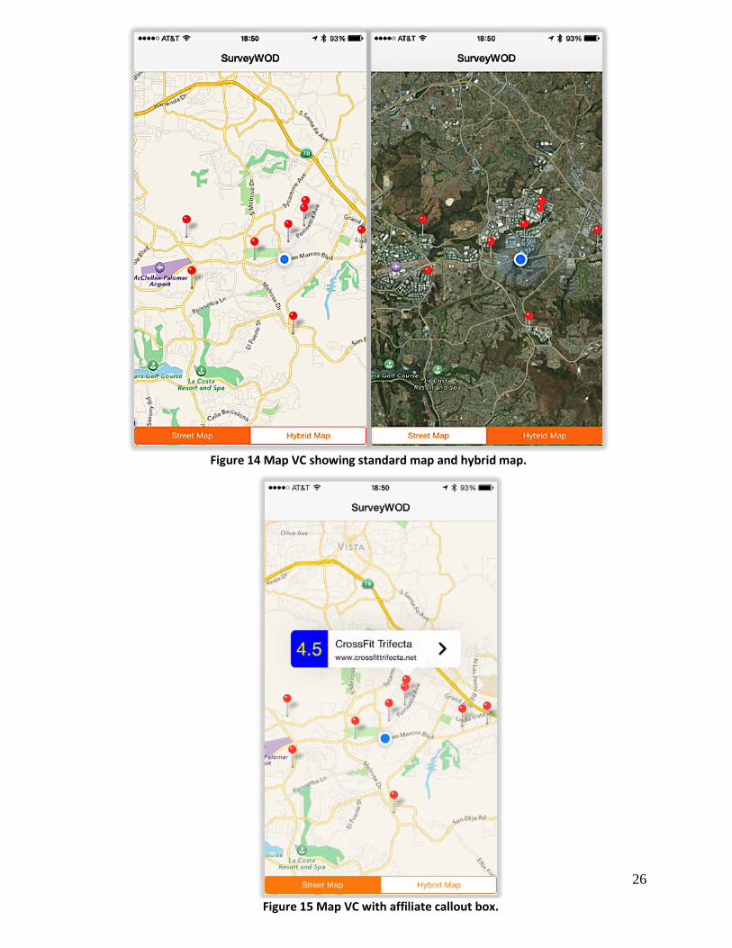
between a standard street map and a hybrid satellite map using the two bottoms located at the
bottom of the Map VC as seen in Figure 14.
If a user selects an affiliate, a callout box appears within the Map VC. The callout box
displays the affiliate name, city, and average overall rating (Figure 15). The user can tap on the
map to dismiss the callout box completely or tap another affiliate to display a new callout box.
Selecting the more details arrow from inside callout box will transition the Map VC to a new
view that provides more information about the selected affiliate.
26
Figure 14 Map VC showing standard map and hybrid map.
Figure 15 Map VC with affiliate callout box.

27
3.5.2 Detailed Information View
The detailed information view referred to as the Detail VC, displays business contact
information and supplementary feedback questions along with their scores as shown in Figure
16. From this view users can select the provided URL, which will display the selected affiliates
website by launching the devices native browser, Safari. A user may also generate driving
directions by selecting the Get Directions button that launches the devices native mapping
application, Apple Maps. If desired, the SurveyWOD back arrow located in the top left corner of
the screen will return the user to the previous Map VC.
Figure 16 Detailed View Controller.

28
3.5.3 Submitting Reviews
Selection of the Submit Review button from within the Detail VC transitions the app to
the third and final screen, referred to as the Review VC. This view contains three survey
questions and a star rating system to score each of the questions (Figure 17). To score a question
the user taps directly on a specific star or they can swipe from right-to-left to pick the star value
they feel is an appropriate response.
Figure 17 Review View Controller.

29
The app features a 5-star rating system that gives each affiliate a rating between 1 and 5
stars. Affiliates with 5 stars signifies an affiliate considered as having a quality above average
and affiliates with 1 star signifies an affiliate considered to have a quality below the average.
There is one overall rating for each affiliate and a separate rating for the following two items: (1)
knowledge, capability, and overall quality of the coaching staff (2) quality, condition,
accessibility, and cleanliness of both the facility and equipment. By associating each quality with
a 5-star rating, it helps mitigate the issue of having an oversimplified rating system with
undefined characteristics because values correlate directly to qualities that consumers can
interpret.
To calculate scores, each question links back to a Parse table that stores all scored
feedback values. Pressing the Submit button causes the averaging of entered scores with
previously entered values stored in their respective Parse table so that average values are
cumulative totals. Using Parse allows survey results to update and immediately be viewable by
any device running the app in real-time and addresses the third design objective outlined in
Section 1.2.
3.5.3.1 Push-Notifications

30
If a device crosses a geotrigger boundary a push-notifications will appear regardless if the
app is open or closed (Figure 18). When a push-notification requesting user feedback is received,
users follow the same review process discussed in section 3.5.3. The only difference is that the
user must launch the app manually if it is not currently open and then select the corresponding
affiliate they would like to review.
Figure 18 Offline push-notification.

31
CHAPTER 4: APPLICATION EVALUATION
This chapter examines field-testing and user evaluation of the SurveyWOD app built as a part of
this thesis project. Section 4.1 provides a general overview of the solicitation and selection
process followed by basic demographics of evaluators. Section 4.2 reviews the standards for app
evaluation and the steps evaluators took during testing. Section 4.3 discusses the collecting of
evaluator feedback related to app functionality and provides a breakdown of survey questions
and a summary of results.
4.1 Selecting Evaluators
Published on the social media website Facebook.com during the month of April 2015, a
request for potential evaluators went out. Criteria for selecting of evaluators considered if
potential candidates reside in or are able to travel to the North County Coastal region of San
Diego, ability to participate in a CrossFit class (no experience necessary), and their ability to
complete an online survey upon conclusion of testing the application. Eleven people responded
and volunteered to test and provide feedback on the app between 25 April and 2 May 2015.
Selected evaluator’s are all residents of San Diego County with limited knowledge of geospatial
system and concepts, but each stated that they were comfortable working with mobile
applications used for mapping purposes. Of the eleven evaluators, six attend a CrossFit gym on a
regular basis, one did CrossFit regularly at home, one tried CrossFit but does not attend a gym
regularly, one did CrossFit infrequently at home or at an affiliate, and the remaining two have
never tried CrossFit before using the app.
To test the app, Apple offers the use of an Ad-Hoc provisioning license option that lets
the developer load the app on a limited number of devices without uploading to the Apple iTunes
App Store (Apple Developer 2015b). For this project, the app only existed on one mobile device,

32
an Apple iPhone 6 provided to evaluators to conduct field-testing. In addition to using the same
device, evaluators followed a similar workflow while testing the app. The guidelines presented to
evaluators guarantees exploration of each function within the app and lends to producing more
comparable user experiences to measure derived feedback.
4.2 Evaluation Process
Before commencement of the assessment process, each evaluator receives a handout with
a list of tasks to complete during testing (Figure 19). Having each evaluator complete similar
steps ensures all available functionality within the app is tested and it yields a more comparable
user experiences to help normalize post evaluation feedback.
Starting at a geographic location independent of an affiliate location, testing begins by
launching the app on the provided mobile device. The initial map display centers on the devices
current location and immediately populates with affiliate locations. The evaluator then chooses
Figure 19 Evaluator task list.

33
an affiliate of their liking in which they will visit and complete a CrossFit class to provide
feedback for.
From the map display, the evaluator selects their chosen affiliate to view the name and
current rating via the callout box. Next, additional business information screen appears when the
evaluator taps the more details arrow. The complete address, phone number, website, and survey
results are displayed for the evaluator to review. Launching of the affiliates business website
from the app is available but is an optional step because it does not utilize core application
functionality to perform the task. Following the provided task list, evaluators generate driving
directions to their chosen affiliate by selecting the Get Directions button that launches Apple
maps (Figure 20). Although this function uses Apple maps to generate driving directions, it helps
Figure 20 Apple Maps driving direction.

34
evaluate the accuracy of geocoded affiliate addresses. Using the calculated directions, evaluators
then travel to the affiliate where they participate in an hour-long CrossFit class. During the
duration of the class, the app remains open and running.
Upon conclusion of the CrossFit class and exit from the facility, the mobile device
receives a push-notification prompting for user feedback (Figure 21). Taking less than one
minute, push-notifications arrive almost immediately after evaluators exit the geotrigger
The final step in field-testing the app requires evaluators to go back into the app, open the
Detail VC for the affiliate they visited. From there, they select the Submit Review button that
takes them to a survey where they can review the affiliate. Based on their experience while
Figure 21 Push-notification requesting user feedback.

35
attending the CrossFit class, evaluators score each of the three provided questions and select
Submit to enter their final survey scores. After submission, the app displays a notification that
thanks the user for the offered input and to confirm submission (Figure 22). Completion of the
survey concluded the evaluator testing of the app.
Figure 22 Survey submission confirmation.

36
4.3 Post-Evaluation Surveys
Immediately following completion of field-testing, each evaluator receives a web link
that grants them access to an anonymous online survey created using SurveyMonkey
(SurveyMonkey 2015). The post-evaluation survey has a total of nine questions for evaluators to
answer. The first asks about each evaluators experience with CrossFit, followed with six
questions that ask about details specific to app functionality to determine if the project goals and
design objectives were achieved, while the final two questions ask the evaluator to rate the app
overall and to provide any recommendations for improvements. Evaluators have the option to
respond with either Yes, No, or Somewhat to the six questions concentrated on project objectives.
To rate the app overall, evaluators can score the app on a scale of 0 - 10, where 0 is considered
below average and 10 is considered above average. Lastly, an open text field permits user to
recommendations or improvements for the app.
4.3.1 Examination of Survey Questions
The following section provides a detailed breakdown of each survey question answered
by evaluators. Each summary includes with an associated graph of analyzed results that
illustrates the distribution of percentages of evaluator responses.
Q1: How much experience do you have with CrossFit?
The only demographics collected as part of the post-evaluation survey enquired about the
level of exposure each evaluator had with CrossFit. Six respondents making up 54.55% stated
that they CrossFit regularly at an affiliate location, two respondents at 18.18%, stated that they
had never tried CrossFit, while the three remaining respondents fell into a three separate groups.
At 9.09%, each of the three respondents chose that they did not CrossFit regularly, did CrossFit

37
infrequently at home or an affiliate, or that they did CrossFit regularly at home. Figure 23
illustrates the percentages associated with Question 1.
Figure 23 Pie chart and percentage table of Question 1 results. Image source: SurveyMonkey (2015)
38
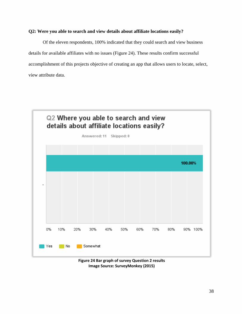
Q2: Were you able to search and view details about affiliate locations easily?
Of the eleven respondents, 100% indicated that they could search and view business
details for available affiliates with no issues (Figure 24). These results confirm successful
accomplishment of this projects objective of creating an app that allows users to locate, select,
view attribute data.
Figure 24 Bar graph of survey Question 2 results Image Source: SurveyMonkey (2015)
39
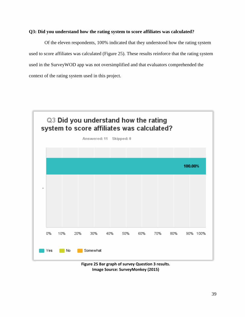
Q3: Did you understand how the rating system to score affiliates was calculated?
Of the eleven respondents, 100% indicated that they understood how the rating system
used to score affiliates was calculated (Figure 25). These results reinforce that the rating system
used in the SurveyWOD app was not oversimplified and that evaluators comprehended the
context of the rating system used in this project.
Figure 25 Bar graph of survey Question 3 results. Image Source: SurveyMonkey (2015)

40
Q4: Did you find the in-app review questions to be relevant and of value?
Ten respondents comprising 90.91% of evaluators believed that the in-app reviews
questions about affiliates were relevant and of value while only one respondent, 9.09% only
found them of somewhat relevance and value (Figure 26). The one respondent that stated
questions were only somewhat of value came from the evaluator who do CrossFit regularly at
home and therefore conditions of equipment and couching staff are possibly of less value to
them.
These results demonstrate that appropriate survey questions were chosen and the threat of
selecting irrelevant survey questions or survey questions only the examiner determined to be of
value as discussed in Section 2.3.3 did not occur in this project.
Figure 26 Bar graph of survey Question 4 results. Image Source: SurveyMonkey (2015)

41
Q5: Did the push-notification help or hinder your decision to immediately leave feedback?
Seven respondents, 63.64% of evaluators stated that the push-notification helped in their
decision to provide feedback immediately after exiting the affiliate (Figure 27). The remaining
four, 36.36%, stated that it only somewhat persuaded their decision to provide feedback. These
responses could have occurred due a users negative inclination towards completing surveys or
that they simply did not feel a desire to leave a review after receiving the push-notification. A
possible means to persuade users towards completing surveys could come from the use of
incentives. Because the app is not specific to one business, incentives would have to come from
outside sources. These outside sources would include vendors that already target the CrossFit
community such as companies that make sell nutrition supplements or apparel companies.
A primary goal of this project is the app’s ability to influence users to provide VGI in the
form of feedback. Either fully or partially, all evaluators were inclined to give feedback, which
confirms achievement of the objective.

42
Figure 27 Bar graph of survey Question 5 results. Image Source: SurveyMonkey (2015)

43
Q6. Did you find the SurveyWOD app to be useful?
Ten respondents, 90.91% of evaluators, found the SurveyWOD app to be helpful in
searching, viewing, and overall functionality with only one respondent, 9.09%, found the app
somewhat useful (Figure 28). The one respondent that stated the app was somewhat of value
came from the evaluator who did CrossFit infrequently at home thus the app may seem less
appealing because it would not be used on a regular basis. Overall, the results indicate that app
met its goal of creating a useful tool to determine which affiliate they should patronize and that
collects, compiles, and delivers relevant business reviews back to consumers quickly and in a
user-friendly format.
Figure 28 Bar graph of survey Question 6 results. Image Source: SurveyMonkey (2015)

44
Q7. Did the SurveyWOD app function as expected?
Ten respondents, 90.91% of evaluators, verified the SurveyWOD app functioned as
intended and without issue. One respondent at 9.09% of verified the app only somewhat
functioned as intended (Figure 29). During field-testing of the app, one evaluator did not receive
a push-notification after exiting an affiliate location, which explains the one response of “no”.
After researching the issue, it was determined that the size of the geotrigger boundary did not
meet minimum size requirements recommended by the Esri Developer site (Esri 2015). After
increasing the geotrigger boundary, the app could successfully send push-notifications to the
mobile device.
Figure 29 Bar graph of survey Question 7 results. Image Source: SurveyMonkey (2015)

45
Q8. On a scale of 0 to 10, how would you rate the SurveyWOD app overall?
Evaluators were asked to score the SurveyWOD app on a scale of 0 – 10 were below
average would receive a score of 0 and above average would receive a score of 10. Four
respondents, 36.36%, scored the app at a 10, three respondents, 27.27%, scored the app at a 9,
and the reaming four, 36.36%, scored the app at an 8 (Figure 30). Reaction to the app was
overwhelmingly positive and evaluators scored the app higher than anticipated which concludes
that the app developed as part of this project met each of its objectives.
Figure 30 Pie chart of survey Question 8 results. Image Source: SurveyMonkey (2015)

46
Q9. Do you have any additional recommendations for improving the app?
The final post-evaluation survey question asked evaluators to provide recommendations
for future improvement from evaluators. This open-ended question received input from seven of
the eleven evaluators. Figure 31 provides a list of recommendations submitted be evaluators.
The capacity to search affiliates by address, city, or zip code was the most common
request that came from three of the evaluators. Incorporating a search toolbar would add a more
dynamic user experience, would allow users to have more control over how they operate within
the app, and could lend itself to users looking to research affiliates outside of their geographic
area. The next request, to incorporate a filtering system to sort either affiliates or reviews, came
from two evaluators and could enhance user ability to search affiliates. One suggestion included
asked that to allow users the ability to upload photos. Having photos could influence and assist
users select an affiliate to attend and is supported by the Parse SDK.
Figure 31 Survey Question 9 list of improvement recommendations. Image Source: SurveyMonkey (2015)

47
4.4 Summary
This project successfully evaluated the effectiveness of a mobile application utilizing
geotriggers to prompt for and aid in the collection of business oriented VGI in the form of
consumer surveys. Evaluator responses were especially positive regarding this functionality and
the ability of the app to address consumer concerns when selecting an affiliate. Survey results
validate the applicability to the SurveyWOD app to add value to CrossFit community or those
interested in CrossFit.

48
CHAPTER 5: CONCLUSION
This chapter discusses usefulness of the SurveyWOD app and how it met each of the project
objectives outlined in Chapter 1. Section 5.1 reexamines project goals and how this project
addressed them. Section 5.2 discusses future design considerations and improvement of the app.
Section 5.3 briefly covers how this app contributed to the study of VGI and Section 5.4 examines
the lessons learned during this project.
5.1 Responding to Project Objectives
The app collected business oriented VGI in near-real time for CrossFit affiliates with the
help of the Esri Geotrigger Service. VGI consisted of surveys that held scores for particular
qualities unique to CrossFit. Aggregated scores were average and then used to generate ratings
for individual CrossFit affiliates. Users of the app can view and rapidly search through the
affiliate database to identify locations that scored highest or are within close proximity to the
devices current location. Through these functions, the app was successfully able to achieve each
of the key project goals outlined in Chapter 1.
Using the Esri Geotrigger Service, users successfully received push-notifications when
the mobile device exited a designated geofence. Received push-notifications were effective in
their ability to encourage users to submit VGI as consumer surveys. The gathered business
oriented VGI from all users fed directly back into the app and accomplished the primary goal of
this project. Using Parse cloud storage to retain affiliate data and Apple native frameworks such
as MapKit to display affiliate locations, accomplished two additional projects goals. The first
being to design an app that allows users to locate, select, view attribute data, and generate
driving directions for affiliates within a feature database. The third, to provide survey data back

49
to the end user in real-time from within the app via a graphical map display and evaluated by
users as needed.
5.2 Future Design Considerations
Throughout the entire design and development process, future improvements for the
SurveyWOD app were considered. The first of which includes increasing the affiliate dataset size
to include the entire United States and eventually to a worldwide affiliate feature dataset.
Affiliate data maintained by CFHQ it not readily available for download but through the process
of web scrapping, the technique of extracting information from existing websites, geographic
coordinate information is accessible. Coordinate information would need to undergo a reverse
geocoding process. Unlike standard geocoding that extracts coordinates from a physical address,
the reverse geocoding process extracts a physical address from given coordinates. Once
complete, data would be added to the existing Parse table. This would give users access to a
much larger database and the app could collect reviews regardless of geographic location. In-app
solicitation for users to suggest corrections, deletions, or additions would be the most efficient
and timesaving approach to accomplish validation of affiliates.
Other excellent recommendations for improvements that came from evaluators include
adding the ability to upload user pictures and adding the option to filter the map display of
locations based on affiliate rating could improve the app and create a more interactive user
experience. Both recommendations would require modification to application code but could be
accomplished by with minimal effort from a proficient developer familiar with the Objective C
programming language.
Other considerations for improvement would focus on implementation of additional
survey methods aimed at collecting more statistically accurate data from users. Potential methods

50
could include the use of a Likert scale, similar to a 5-star rating but with less ambiguity in
relation to scoring. The Likert scale uses anchors that respondents can reference when
completing surveys (Babbie 2010). In addition, research conducted at the Massachusetts Institute
of Technology implies that having users compare products in pairs offers a more accurate
representation of consumer preference (Jagabathula and Shah 2011), which is a viable option as
well. Users could also benefit by knowing how many other people have left reviews. This would
help to authenticate review validity in terms of knowing that a four star review based on a 100
response versus carries more weight than a five star review based on one review.
After implementing functional improvements, further development would demand the
app to be platform independent. This means that that the app could run on any mobile device, not
just Apple. The ability to reach a larger consumer base and potentially influence a wider cross
section of the population would then exist. More importantly is to recreate the same functionality
found within the app on the web, which would help further collection and delivery of reviews to
users instead of rely solely on the mobile app. A key benefit of having a web presence would
permit for implementation of a mechanism to launch affiliate consumer surveys directly from
received push-notification via a web browser. This would eliminate the need for users to re-
launch the app, search for the affiliates, and navigate to review screen would no longer exist.
Overall, the development and methodology behind the SurveyWOD app presents a
valuable tool for the collecting user feedback. Fully expandable beyond the scope of this project,
the app can easily use any business model, geographic area, or feature dataset size. Because all
technology used in this project is opens source, a potential developer could certainly follow the
guidelines presented in Chapter 3 to reconstruct the app to their liking.

51
5.3 Contribution to VGI
This thesis and the SurveyWOD app contribute to VGI through the incorporation of
geotriggers to prompt users for VGI in near real-time. This approach to collecting VGI presented
a means to improve data credibility and accuracy by guiding the collection of VGI through two
primary methods. The first method uses structured surveys with questions related directly to a
business or service. This enables users to provide VGI concentrated on one specific topic. The
second method of using predetermined geographic data points (of business locations) helps users
to identify a specific business for submitting their reviews.
5.4 Lessons Learned
During early planning and development of this project issues arose that directly affected
app implementation. Initially the SurveyWOD app was designed for the Android mobile
platform using the Eclipse IDE. The Eclipse failed to provide an intuitive user environment
especially when it came to debugging. An example includes the error messages that Eclipse uses
to notify when the developer when a problem has occurred. These notifications are often cryptic
and somewhat confusing because they can require that the developer have a very clear
understanding of code structure often lacking in a less experienced developer. Unlike Apple that
seamlessly integrates a multitude of native frameworks, Android requires more effort from the
developer to integrate resources. Xcode also uses a graphical interface builder that helped to in
the design process because it could fill in sections of code simply by adding objects to the
display. Lastly, Xcode uses an instinctive syntax builder that helped with proper code
composition. Each of these reasons made development for the Apple platform an exceedingly
better choice.

52
After verifying that Apple would be the target platform, the choice to use the newly
released Swift programming language seemed an obvious choice. Unfortunately, issues arose
from that fact that the Esri Geotrigger SDK was written in Objective C. Even after coordination
with the Esri Portland Research & Development Office that developed the Esri Geotrigger SDK,
complications continued to plague the development process while trying to integrate the SDK
into a Swift project. By switching the to the previous industry standard of the Objective C
programming, no further issues were encountered that were related to the Esri Geotrigger
Service.
Once the Esri Geotrigger began to function properly, all other aspects of development,
fell into place. Only minor coding challenges arose that and remedied by using web resources
such as Stack Overflow (2015). Stack Overflow is a community blog were users post questions
regarding issues they have encountered, which are then answered by fellow peers. This resource
helped address coding questions that were beyond my skillset but linking me with various
professionals.

53
REFERENCES
7-Eleven. 2015. “Mobile App Information.” https://www.7-eleven.com/Only-at-7-Eleven/App/.
(accessed 12 November 2014).
Anderson, M. 2013. “2013 Study: 79% of Consumers Trust Online Reviews As Much As
Personal Recommendation.” http://serachengineland.com/2013-study-of consumers-trust
online-reviews-as-much-as-personal-reccomendations-164565. (accessed 15 April 2015).
Apple Developer. 2015. “Apple iOS Developer Center.”
https://developer.apple.com/devcenter/ios/index.action. (accessed March 2015).
Apple Developer. 2015b. “Apple iOS Beta Testing Guidelines.”
https://developer.apple.com/library/ios/documentation/IDEs/Conceptual/AppDi
tributioGuide/TestingYouriOSApp/TestingYouriOSApp.html. (accessed 7 April 2015).
Apple Developer. 2015c. “iOS 8 Human Interface Guidelines.”
https://developer.apple.com/library/ios/documentation/UserExperience/Concep
ual/MobieHIG/. (accessed 7 April 2015).
Arigos, B., and Mann, K. 2010. “ArcUser Summer 2010. Getting in Touch with Volunteered
Geographic Information.” http://www.esri.com/news/arcuser/0610/files/vgitutorial.pdf
(accessed 11 May 2015).
Babbie, E. 2010. “The practice of social research.” Belmont, CA: Wadsworth Pub. Co.
Baumeister, R.F., E. Bratslavsky, C. Finkenauer, and K. D. Vohs. 2001. “Bad is stronger than
good.” Review of General Psychology 5, (4): 323-370.
Beers, E. 2014. “Virtuosity Goes Viral.” The CrossFit Journal.
http://library.crossfit.com/free/pdf/CFJ_2014_06_10000_Beers3.pdf.
(accessed August 2014).

54
Carr, C. 2013. “Think Like a Geek God: Psychology behind the 5 star rating.”
http://www.webpagefx.com/blog/internet/psychology-behind-5-star-rating-online
reviews/. (accessed 11 May 2015).
CocoaPods. 2015. “Xcode Dependency Manager.” http://cocoapods.org/.
(accessed 20 April 2015).
Coleman, D.J., Georgiadou, Y. and Labonte, J. 2009. “Volunteered Geographic Information:
The Nature and Motivation of Produsers.” International Journal of Spatial Data
Infrastructures Research, 4: 332-358.
comScore. 2015. “comScore Reports February 2015 U.S Smartphone Subscriber Market
Share.” http://www.comscore.com/Insights/Market-Rankings/comScore-Reports-
February-2015-US-Smartphone-Subscriber-Market-Share. (accessed 4 May 2015).
CrossFit HQ. 2011. “Official CrossFit Affiliate Gym Locator.” http://map.crossfit.com/.
(accessed April 2015).
Dietz, C., and J. Suh. 2012. “Volunteered Geographic Information: Selected Web Resources.”
ALA Map and Geospatial Information Round Table Electronic Publication, 12.
Ditlev, J. 2012. “Review Strategy: How to get the most out of customer reviews.”
http://blog.trustpilot.com/review-strategy/. (accessed July 2014).
Dunkin Donuts. 2011. “Mobile App Information”.
http://www.dunkindonuts.com/dunkindonuts/en/mlanding.html. (accessed 12 November
2014).
Elise, A. 2015. “Apple Dominates Smartphone Industry With 93 Percent Of The Profits.”
International Business Times. http://www.ibtimes.com/apple-dominates-smartphone-
industry-93-percent-profits-1811324. (accessed May 2015).

55
Esri. 2014. “Esri Geotrigger SDK for iOS. 2014. Esri Geotrigger Service.”
https://github.com/esri/geotrigger-sdk-ios. (accessed December 2014).
Esri. 2015. “ArcGIS Developer. Esri Geotrigger Service Guide for iOS.”
https://developers.arcgis.com/geotrigger-service/guide/ios-getting-started/. (accessed
January 2015).
Esri. 2015b. “ArcGIS for Developers.” https://developers.arcgis.com. (accessed February 2015.)
Esri. 2015c. “ArcGIS Runtime SDK for iOS.” https://developers.arcgis.com/ios/guide/. (accessed
December 2014).
Expedia. 2015. http://www.expedia.com/. (accessed 25 May 2015).
Flanagin, A. J., and M. J. Metzger. 2008. “The credibility of volunteered geographic
information.” GeoJournal, 72 (3/4):137-148.
Foursquare. 2015. “Mobile App Information.” Accessed February 2015. https://foursquare.com/.
Geoloqi. 2013. “Beta Launch of Esri Geotrigger Service!.” https://geoloqi.com/blog/. (accessed
23 September 2014).
General Accounting Office (GAO). 1991. “Using Structured Interviewing Techniques.
Washington. Program Evaluation, and Methodology Division.”
http://www.gao.gov/special.pubs/pe1015.pdf. (accessed September 2014).
GitHub. 2014. “Esri Repository.” https://github.com/Esri/geotrigger-sdk-ios/. (accessed 6
December 2014).
Glassman, G. 2002. “Foundations.” The CrossFit Journal Online.
http://journal.crossfit.com/2002/04/foundations.tpl. (accessed 14 January 2015).
Goodchild, M.F. 2007. “Citizens as sensors: the world of volunteered geographic information.”
GeoJournal, 69 (4): 211-221.

56
Google+. 2015. “Google+ Information”. https://plus.google.com/. (accessed December 2014).
Hélesbeux, T. 2013. “Rating View”. https://github.com/Tgy31/RatingView.
(accessed March 2015).
iOS 8. Apple Inc. Cupertino, California, United States of America. https://www.apple.com/ios/.
(accessed 12 April 2015).
Jagabathula, S., and D. Shah. 2011. “Inferring rankings using constrained sensing.” IEEE
Transactions on Information Theory 57, (11): 7288-7306
Jenkins, B.B. 2015. “Tips for choosing a CrossFit gym. Breaking Muscle.”
http://breakingmuscle.com/functional-fitness/tips-for-choosing-a-crossfit-gym.
(accessed 1 April 2015.
Lewis-Kraus, G., P. 2013. Yelp and the Wisdom of “The Lonely Crowd”. The New Yorker.
http://www.newyorker.com/tech/elements/yelp-and-the-wisdom-of-the-lonely-crowd.
(accessed 15 September 2014).
Marshall, P. 2013. “Geotrigger puts Geofencing in Esri Mobile Apps. Government Computer
News.” http://gcn.com/Articles/2013/12/06/Esri-geotrigger.aspx.
(accessed August 2014).
Millholland, N.E. 2014. “Exploring San Francisco Treasures: Mashing Up Public Art, Social
Media, and Volunteered Geographic Information to Create a Dynamic Guide.” Masters
Thesis. University of Southern California.
Nait-Sidi-Moh, A., and M. Dias de Amorin. 2013. “Geopositioning and Mobility. London:
Hoboken, N.J: Wiley-ISTE. Namiot, D., and M. Sneps-Sneppe.” 2013. Geofence and
Network Proximity. Internet of Things, Smart Spaces, and Next Generation Networking,
8121, pp. 117-127.

57
Nait-Sidi-Moh, A., Bakhouya, M., & Gaber, J. 2013 Geopositioning and Mobility, John Wiley &
Sons, Somerset, NJ, USA. Available from: ProQuest ebrary. Accessed 11 January 2015.
Pew Research Center. 2015. “Cell Phone Activities 2013.”
http://www.pewinternet.org/2013/09/19/cell-phone-activities-2013/. (accessed 2
February 2015)
PRNewswire. 2014. “Expedia, Inc. Licenses Routehappy Scores & Happiness Factors API For
Integration Into Search Results, Helping Flyers Find Happiness”.
http://www.prnewswire.com/news-releases/expedia-inc-licenses-routehappy-scores--
happiness-factors-api-for-integration-into-search-results-helping-flyers-find-happiness-
282141751.html. (accessed 27 May 2015).
Routehappy. 2015. https://www.routehappy.com/. (accessed 27 May 2015).
Stack Overflow. 2015. http://stackoverflow.com/. (accessed November 2015).
SurveyMonkey. 2015. http://www.surveymonkey.com. (accessed 3 May 2015).
Tengku Noor Shamsiah Tengku Abdullah. 2014. “ESRI Introduces New Technology to –
Geotrigger – Malaysian E-Shopping Revolution.” Bernama: Malaysian National News
Agency 2014.
Tugui, A. 2004. “Calm technologies in a multimedia world.” Ubiquity, March (2004): pp. 1-1.
Urbanspoon. 2015. “Site Information.” http://www.urbanspoon.com. (accessed 20 April 2015).
Usman, Z., Fawzi A., Amina T., and Talal Naveed, P. 2010. “Relative ranking – A biased
rating.” In , 25-29. Dordrecht: Springer Netherlands
Veremette, S. 2011. “SVProgressHUD.” http://www.samveremette.com. (accessed March 2015).
Warf, B. 2010. “Geocoding.” Encyclopedia of Geography. Thousand Oaks, CA: Sage
Publications. pp. 1209-1210.

58
Wodify. 2015. “Site Information.” http://www.wodify.com/. (accessed December 2014).
Xcode 6.2.1, Apple Inc. Cupertino, California, United States of America.
https://developer.apple.com/xcode/. (accessed November 2014).
Yelp. 2015. “Site Information.” http://www.yelp.com/. (accessed February 2015).