Embed Size (px)
Citation preview
TransportationPlanning Branch
GTA West CorridorPlanning and EA Study – Stage 1
Presentation to Peel Goods Movement Task Force
April 8 2011
Draft Transportation Development Strategy

2TransportationPlanning Branch
Study Areas

3TransportationPlanning Branch
Unique Approach
• Unprecedented two-stage EA process:– Stage 1: Need and multi-modal alternatives– Stage 2: Route location for new corridor
• Stage1 is a robust multi-year, multi-modal planning process:– No pre-defined “undertaking”– Considers all modes of transportation – determines system needs– Outcome is a multi-modal Transportation Development Strategy– Supported by 4 rounds of consultation
• Within provincial policy context – Greenbelt Plan, Growth Plan for the Greater Golden Horseshoe, Provincial Policy Statement (PPS)
• Builds on other transportation plans – such as Metrolinx RTP, York Viva, GO 2020, Brampton Züm

4TransportationPlanning Branch
Study Process – Stage 1
Transportation Alternatives
Transportation Development Strategy
Transportation Problems & Opportunities
Terms of Reference
PIC 2
2007
PIC 3PIC 1 PIC 4
• Overview of Transportation and Socio-Economic Conditions Report
• Overview of Environmental Report Conditions and Constraints Report
• Study Vision, Purpose, Goals, and Objectives Discussion Paper
• Factors Influencing Transportation Demand Discussion Paper
• Transportation Problems and Opportunities Report
• Transportation Alternatives Report
• Transportation Development Strategy
2011
We are Here
PIC Public Information Centre

5TransportationPlanning Branch
Challenge of Managing Growth
Additional transportation improvements will be required to support future growth
Greater Golden HorseshoePopulation: +2,930,000 (34% growth)Employment: +1,250,000 (29% growth)
GTA West Study Area:Population: +750,000 (75% growth)Employment: +390,000 (75% growth)
Growth from 2006 to 2031
GTA West

6TransportationPlanning Branch
Building on Other InitiativesGO 2020 Strategic Plan
Metrolinx RTP

7TransportationPlanning Branch
Building Block Approach
2222Group Group Group Group 2222Group Group Group Group
New/Expanded Non-Road Infrastructure
• Group 1 plus• Transit• Rail
• Air• Marine
Widen / Improve Roads
• Group 2 plus
• Widen / ImproveRoads & Highways3333GroupGroupGroupGroup 4444GroupGroupGroupGroup 4444GroupGroupGroupGroup
New Transportation Corridors
• Elements of Group 3 plus• New Transportation
Corridors
Develop Reasonable Combination Alternatives To Address Problems & Opportunities
Key Steps:
Assess Combinations to Identify Advantages & Disadvantages
• Transit• Rail• Roads & Highways• Air
Group Group Group Group
• Marine• TDM• TSM• Inter-modal
Optimize Existing Networks
1111
DecisionTrade-offs
•Environment
•Community
•Economy

Key Elements of the Strategy
• Optimize use of existing transportation infrastructure through Transportation Demand Management and Transportation System Management measures, in cooperation with Metrolinx
• Support implementation of the transit initiatives in Metrolinx RTP and GO 2020
• Initiate a study to investigate inter-regional transit opportunities linking western urban centres
• Widen selected highways to provide additional capacity, including potential HOV lanes
• Protect and implement a new transportation corridor from Highway 400 westerly to Highway 401, east of the Niagara Escarpment
Key Elements of the recommended new corridor• a new transportation corridor from Highway 400 westerly to Highway 401 on the west side
of Milton, east of the Niagara Escarpment; and
• a North-South Link to Highway 401/407 ETR, which would provide key ramp connections that serve long-distance, inter-regional traffic.
8
Recommended Draft Transportation Development Strategy

9TransportationPlanning Branch
Recommended Draft Transportation Development Strategy
10TransportationPlanning Branch
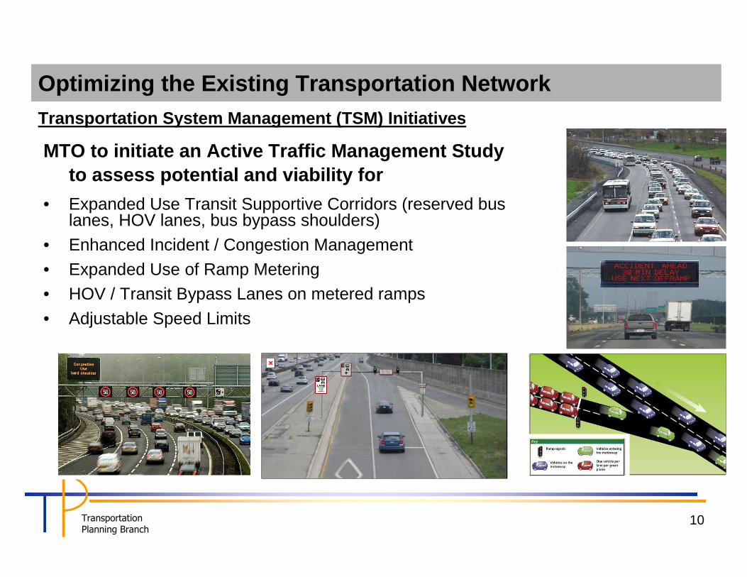
MTO to initiate an Active Traffic Management Study to assess potential and viability for
• Expanded Use Transit Supportive Corridors (reserved bus lanes, HOV lanes, bus bypass shoulders)
• Enhanced Incident / Congestion Management
• Expanded Use of Ramp Metering• HOV / Transit Bypass Lanes on metered ramps
• Adjustable Speed Limits
Optimizing the Existing Transportation Network Transportation System Management (TSM) Initiatives

11TransportationPlanning Branch
Transportation Demand Management (TDM) Initiatives
MTO to work with Metrolinx and area communities to expand the Smart Commute program beyond the GTHA into Guelph and Wellington County area and Waterloo area
– Enhancements to current programs– Expansion of MTO’s Carpool Lot Program– Explore opportunities to provide funding assistance
Optimizing the Existing Transportation Network

12TransportationPlanning Branch
New/Expanded Non-Road Infrastructure
Support the implementation of Metrolinx’s RTP and GO 2020 initiatives
• Rapid Transit
• Regional Rail expansion
• Express Rail
Further studies to investigate potential of additional transit initiatives
• Expanded inter-regional GO Bus routes
• New Bus Rapid Transit Links between Urban Growth Centres
• Transit Network beyond GTA West Study Area – Inter-regional transit links between Urban Growth
Centres in Western GGH – Mobility hubs in the downtowns of Brantford,
Cambridge, Guelph, Kitchener and Waterloo (in addition to downtown Brampton and downtown Milton)

13TransportationPlanning Branch
Long-Term Transit Network
• Continue to improve connection to Toronto with outlying urban centres to reduce car use
• Provide better transit between outlying urban centres –
– Improve mode choice – Serve as gateways to
smaller rural communities

14TransportationPlanning Branch
Widening of Existing Highways
– 401 (from Hwy 6 to Credit River)– 410 (from 401 to Mayfield Road)– 427 (from 407 to Hwy 7)– 400 (from 407 to Hwy 9)– 407 ETR (from 401 to 400)
MTO, 407 ETR undertake Class EA studies for the widening of the following highways within the GTA West study area:

15TransportationPlanning Branch
New Transportation Corridor
• MTO initiate Route Planning and preliminary design (Stage 2 of EA Study) for a new corridor from Hwy 400 in Vaughan to Hwy 401 west of Milton, with a North-South link to Hwy 401/407 ETR
– new corridor with 170 m right-of-way can accommodate a highway including HOV lanes, transitway, and truck-only facility (truckway)
– new transportation corridor would be pursued in combination with widening of existing highways
• MTO, in conjunction with MMAH, work with municipalities to protect the land for the new transportation corridor during Stage 2 of the EA
• A Preliminary Study Area for Route Planning (Stage 2 EA) has been developed (next slide)
– Established on principles considering geometric design standards, avoiding/minimizing impact on existing communities and environmental features
– Conducted consultation with all affected municipalities – Will provide the basis for Stage 2 EA and corridor
protection

16TransportationPlanning Branch
New Corridor – Preliminary Study Area for Stage 2 EA

17TransportationPlanning Branch
Truck-only Lane or Truck-way Considerations
• Truck-only lanes or exclusive Truck-ways are forms of transportation system management (TSM) measures that improve truck operation through segregation of trucks and other vehicles or by providing special facilities for trucks
• Motivation for truck lanes– To ensure economic competitiveness, growing need to facilitate an efficient
goods movement through the transportation network – Increased competition for road space coupled with diminishing footprints for
expansion create a stronger need to optimize throughput of existing network capacity
– Improved goods and passenger mobility and truck productivity without compromising passenger travel times
– Ensure safe network operation with the separation of truck and auto traffic – Improved accessibility to major truck traffic generating areas, e.g., intermodal
terminals and distribution centres– Savings in total road transportation cost, i.e., capital, O&M, and user costs

18TransportationPlanning Branch
Our Initiatives to Date
• Participate in research studies
– Research study by the University of Toronto– Consultant study for Transport Canada, to produce a “Guidance Document” on
best practices on truck lanes
• Conduct scan and jurisdictional review
• Undertake modelling and forecasting for applicability on 400 series highways in the GGH
• Truckway analysis as part of the GTA West Corridor EA Study

19TransportationPlanning Branch
GTA West Corridor - Truckway Analysis
Segment PM Peak Hour Truck Volume (car equivalent)
Eastbound Westbound
Hwy 401 (W. of Milton) to
Halton-Peel Boundary Area
Transportation Study
1,580 (3,160) 1,480 (2,960)
HP BATS to Hwy 410 1,720 (3,440) 1,960 (3,920)
Hwy 410 to Hwy 427 1,690 (3,380) 1,860 (3,720)
Hwy 427 to Hwy 400 2,200 (4,400) 1,640 (3,280)
2031 PM Peak Hour Truck Volume (car equivalent) between Highway 427 and Highway 400
South Boston Haul Road, Boston Separated Lanes on the New Jersey Turnpike
• The truck-only facility was tested for the GTAW 4-3 configuration to provide a direct connection between Highway 401 and 400
• Increased truck demand on new corridor by 200-400% compared to mixed-traffic facility
• Truck volumes range from 1,600 veh/hr/direction west of Brampton to over 2,200 veh/hr/direction between Highway 427 and Highway 400
• Equivalent of 3,200 to 4,400 passenger cars per hour (equivalent to 2 Freeway lanes per direction)
• Most trucks are to/from Hwy 400 (via north), industrial areas via Highway 400 south, Highway 427, and Airport Road
• Truck volumes on Hwy 401 drop by up to 1,000 veh/hr (2,000 car equivalents), which is equivalent to one freeway lane of capacity
• More analysis required to assess the impacts and to compare to other alternatives
• Carry forward for further consideration as part of the Transportation Development Strategy

20TransportationPlanning Branch
• Municipal and stakeholder consultation following the release of the draft strategy on March 7
• A minimum of 90 days for public/stakeholder review and commenting on the draft Strategy
• Finalize the Transportation Development Strategy report based on input and comments received
• Initiate Stage 2 of EA for the new corridor once the Strategy has been finalized
Next Steps

TransportationPlanning Branch
Appendix A
Elements of the Draft Transportation Development Strategy
TransportationPlanning Branch
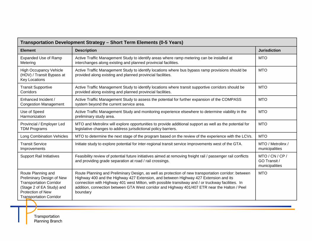
MTORoute Planning and Preliminary Design, as well as protection of new transportation corridor: between Highway 400 and the Highway 427 Extension, and between Highway 427 Extension and its connection with Highway 401 west Milton, with possible transitway and / or truckway facilities. In addition, connection between GTA West corridor and Highway 401/407 ETR near the Halton / Peel boundary
Route Planning and Preliminary Design of New Transportation Corridor (Stage 2 of EA Study) and Protection of New Transportation Corridor
MTO / CN / CP / GO Transit / municipalities
Feasibility review of potential future initiatives aimed at removing freight rail / passenger rail conflicts and providing grade separation at road / rail crossings.
Support Rail Initiatives
MTO / Metrolinx / municipalities
Initiate study to explore potential for inter-regional transit service improvements west of the GTA.Transit Service Improvements
MTOMTO to determine the next stage of the program based on the review of the experience with the LCVs.Long Combination Vehicles
MTOMTO and Metrolinx will explore opportunities to provide additional support as well as the potential for legislative changes to address jurisdictional policy barriers.
Provincial / Employer Led TDM Programs
MTOActive Traffic Management Study and monitoring experience elsewhere to determine viability in the preliminary study area.
Use of Speed Harmonization
MTOActive Traffic Management Study to assess the potential for further expansion of the COMPASS system beyond the current service area.
Enhanced Incident / Congestion Management
MTOActive Traffic Management Study to identify locations where transit supportive corridors should be provided along existing and planned provincial facilities.
Transit Supportive Corridors
MTOActive Traffic Management Study to identify locations where bus bypass ramp provisions should be provided along existing and planned provincial facilities.
High Occupancy Vehicle (HOV) / Transit Bypass at Key Locations
MTOActive Traffic Management Study to identify areas where ramp metering can be installed at interchanges along existing and planned provincial facilities.
Expanded Use of Ramp Metering
Jurisdiction DescriptionElement
Transportation Development Strategy – Short Term Elements (0-5 Years)

TransportationPlanning Branch
MTO407 ETR
MTO to undertake Class Environmental Assessment studies (as required) to investigate and confirm the need, timing and the lane requirement for widening of the following provincial facilities within the GTA West study area (timing and lane requirement also subject to availability of funding):
•Highway 401 oHwy 6 to RR 25 – widen to 10 lanesoRR 25 to James Snow Parkway – widen to 10 lanes*oJames Snow Parkway to 407 ETR – widen to 12 lanes*o407 ETR to Winston Churchill Boulevard– widen to 10 lanes*oWinston Churchill Boulevard to Hwy 410 – widen to 12 lanes*
•407 ETR (no EA required – previously approved)oHwy 401 to Hwy 410 – widen to 10 lanesoHwy 410 to Hwy 427 – widen to 10 lanesoHwy 427 to Hwy 400 – widen to 10 lanes
•Highway 410 oHwy 401 to 407 ETR – widen to 9 lanes*o407 ETR to Steeles Ave – widen to 8 lanes*oSteeles Ave to Queen St – widen to 10 lanes*oQueen St to Mayfield Rd – widen to 8 lanes
•Highway 427o407 ETR to Hwy 7 – widen to 8 lanes
•Highway 400o407 ETR to Major Mackenzie Dr – widen to 12 lanes*oMajor Mackenzie Dr to King Rd – widen to 10 lanes *oKing Rd to Hwy 9 – widen to 10 lanes
Widening of Highways
•Include HOV lanes
Note: The number of lanes proposed as shown reflect the Transportation Development Strategy per the GTA West Study and may differ from current MTO programs.
JurisdictionDescriptionElement
Transportation Development Strategy – Medium Term Elements (5-15 Years)

TransportationPlanning Branch
MTO•New corridor Hwy 400 to Hwy 427 Extension•New corridor Hwy 427 Extension to Hwy 401 west of proposed Tremaine Road interchange•Extension of Hwy 427 to new corridor •Hwy 410 connection to new corridor •New corridor connection from GTA West corridor to Hwy 401/ 407 ETR
Design and construction of new transportation corridors
JurisdictionDescriptionElement
Transportation Development Strategy – Long Term Elements (15-25 Years)