Embed Size (px)
Citation preview

GreenerSites
GEO-INFORMATION TOOLDeliverableD.T1.2.3
Version 111/2017

IntroductionThe GreenerSites Tool is as a site information system for online collaboration of publicauthorities and other stakeholders that are concerned with brownfield rehabilitation and sitedevelopment. It is an open source Web-GIS Tool including only the most essential maps anddata. These comprise of basic maps and orthophotos as well as selected thematic maps and amanageable amount of detailed site information. Existing INSPIRE compliant geodata servicesand other web map services (WMS) can be included (e.g. OpenStreetMap, CORINE LandCover,Urban Atlas). Basic features are data sharing, a map viewer, a search function, spatial analysisfunctions (via QGIS) and the possibility to create and export fact sheets. The existing version 1of the tool will be updated after the testing phase in the second quarter 2018.
GreenerSites geo-information tool was designed taking into account project partners' needs andexpectations concerning the management of brownfield data. The tool helps different publicauthorities and other stakeholders to share relevant data and maps related to brownfields. Mostauthorities concerned with remediation and development of contaminated sites already usegeographical information systems (GIS) and specialized database applications. But there aremany different software products on the market which use mostly individual data formats. Thuscooperation between partners using differing GIS products can be difficult. The GreenerSitesWeb-GIS Tool enables partners to equally share their information in a web-based applicationwhich can be accessed by all users. So cooperation is much easier and no one is excluded. Evenstakeholders that have no own GIS can look up the maps in the browser. The tool was developedin Germany but can be used in all European countries, as the tool language is English and thetool is based on the EU-recommended frame of reference for geodata ETRS89 (EuropeanTerrestrial Reference System 1989).
DescriptionThe tool was developed under the guidance of the Ministry for Regional Development andTransport Saxony-Anhalt by Baader Konzept GmbH / mena GmbH, Gunzenhausen (Germany).
As the tool is based on open source components it can be used freely by other stakeholders. Alsothe tool is not limited to the once developed functions but can be extended and tailored to theneeds of certain stakeholders. It comes with an installation routine allowing setting up the tooleasily. Nevertheless, to use the tool it needs more than just to open a browser and startworking. There has to be a GIS administrator to set up and run the tool, to manage the data, andto administrate the different features and users. If the tool is operated locally the hosting of aGIS server is required. The tool manual is available in English and in the other languages of theproject.
The GreenerSites Tool is based on the following open source components (Fig. 2):
• Backend: PostGreSQL/PostGIS, pgAdmin, QGIS, GeoServer
• Frontend: GeoDjango/OpenLayers
Fig. 2: GreenerSites Tool main componenets
1

Each partner region can use their one subdomain to style and organize their website individually(logos, language, etc.). The tool uses a role-based access control. If the user has write rights,editing of the attribute table is enabled after clicking on an existing object (site). A sitefactsheet can be displayed, showing a picture of the actual map view and the attribute table.This factsheet can be exported into a PDF.
Five installation packages adjusted to the local conditions of the particular partner region havebeen provided to the project partners. The tool installation packages (Ansible Playbooks) weredeployed via GitLab and every partner can implement, administrate, and use the tool on its ownresponsibility.
The Greenersites Tool is available at the following links:
http://mlv.greenersites.eu/map/ #
http://armsa.greenersites.eu/map/
http://cob.greenersites.eu/map/
http://celjie.greenersites.eu/map/
http://rijeka.greenersites.eu/map/
http://greenersites.regione.veneto.it.
2
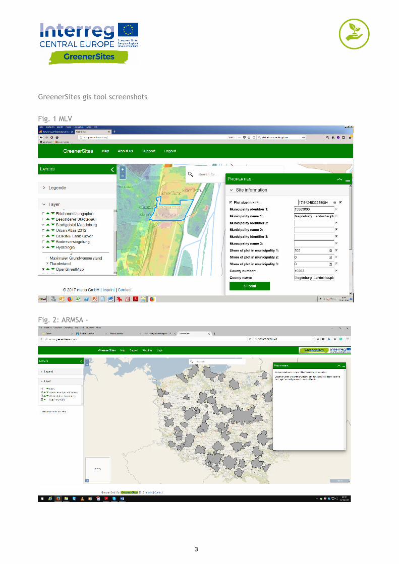
GreenerSites gis tool screenshots
Fig. 1 MLV
Fig. 2: ARMSA -
3

Fig. 3: Bydgoszcz
Fig. 4: MOC
4

Fig. 5: PRA
Fig. 6: Venice
5