Embed Size (px)
Citation preview

Astrium GEO-Information Services
Pléiades International Price List
P a g e | 2
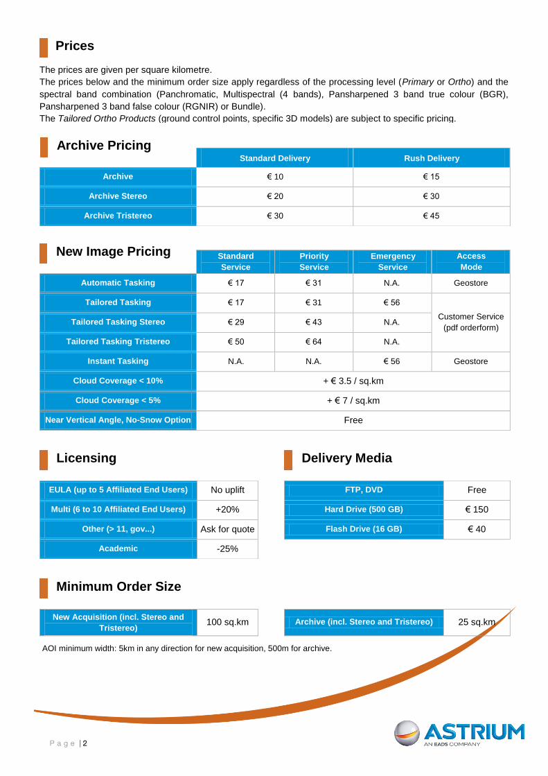
Prices
Licensing
Delivery Media
Minimum Order Size
The prices are given per square kilometre.
The prices below and the minimum order size apply regardless of the processing level (Primary or Ortho) and the
spectral band combination (Panchromatic, Multispectral (4 bands), Pansharpened 3 band true colour (BGR),
Pansharpened 3 band false colour (RGNIR) or Bundle).
The Tailored Ortho Products (ground control points, specific 3D models) are subject to specific pricing.
Standard Delivery Rush Delivery
Archive € 10 € 15
Archive Stereo € 20 € 30
Archive Tristereo € 30 € 45
Standard
Service
Priority
Service
Emergency
Service
Access
Mode
Automatic Tasking € 17 € 31 N.A. Geostore
Tailored Tasking € 17 € 31 € 56
Customer Service
(pdf orderform) Tailored Tasking Stereo € 29 € 43 N.A.
Tailored Tasking Tristereo € 50 € 64 N.A.
Instant Tasking N.A. N.A. € 56 Geostore
Cloud Coverage < 10% + € 3.5 / sq.km
Cloud Coverage < 5% + € 7 / sq.km
Near Vertical Angle, No-Snow Option Free
EULA (up to 5 Affiliated End Users) No uplift FTP, DVD Free
Multi (6 to 10 Affiliated End Users) +20% Hard Drive (500 GB) € 150
Other (> 11, gov...) Ask for quote Flash Drive (16 GB) € 40
Academic -25%
New Acquisition (incl. Stereo and
Tristereo) 100 sq.km Archive (incl. Stereo and Tristereo) 25 sq.km
AOI minimum width: 5km in any direction for new acquisition, 500m for archive.
Archive Pricing
New Image Pricing

P a g e | 3
About Pléiades
The Pléiades twin satellites offer a wide range of products and services. Their unique daily revisit capability means
that time-series imagery, which is ideal for change detection, as well as rapid coverage of broad zones, can be
acquired easily.
Pléiades imagery
Pléiades 50cm resolution products are available in two processing levels: Primary and Ortho.
The Primary product is the processing level closest to the natural image acquired by the sensor. This
product restores perfect collection conditions: the sensor is placed in rectilinear geometry, the image is
clear of all radiometric distortion (colour). The Primary product is optimal for clients familiar with satellite
imagery processing techniques wishing to apply their own production methods (orthorectification or 3D
modeling for example). To this end, RPCs and the sensor model are provided with the product to ensure
full autonomy and simplicity for users.
The Ortho product is an image that has been corrected (viewing angle and ground effects) so that it may
be superimposed on a map. Radiometric and geometric adjustments and the use of a 3D model to
reproduce relief, mean that all “perspective” effects are eliminated, simulating a vertical shot. The Ortho
product is optimal for simple and direct use of the image: it can be used and ingested directly into a
Geographic Information System. This processing level facilitates the management of several layers of
products, from the same sensor or others, while reducing localization gaps that can be caused by different
viewing angles or relief between the various layers. The standard 3D model used for ground corrections is
the worldwide Elevation30 dataset (also known as Reference3D). Upon feasibility study, Astrium GEO-
Information Services can also provide on-demand, custom orthorectification (Tailored Ortho product) with
a more precise 3D model provided by the client or acquired for the purpose. Ingestion of Ground Control
Points can also improve the overall precision of the product.
New acquisition or archive image
Pléiades collects a vast amount of imagery daily since the launch of Pléiades 1, in December 2011. Once acquired
and displayed in our catalogue, these images constitute the Pléiades archive, ready for immediate order (without
collection period). Our updated archive can be browsed on the www.geostore.com catalogue.
A customer may also request that a new image be acquired.
For small Areas Of Interest1, with standard
2 acquisition parameters, the Automatic Tasking Service is
recommended. This service, available online via www.geostore.com, provides an estimated collection time
depending on the requested geographic zone (typically 60 days in easy areas3 and 120 days in difficult
areas4). Smaller collection timeframes (typically 30 days) are available over easy areas. Through the
Automatic Tasking Service, ordering a new image is as simple and quick as ordering an archive image.
The Tailored Tasking Service is ideal for broader, more complex areas of interest, often with specific5
parameters, or for customers who prefer to be accompanied by a dedicated in-house expert. These
customers will benefit from the experience, advice, and follow-up of a satellite tasking specialist, fully
engaged to ensure the success of the customer’s project. This service is accessible through our Customer
Service and opens the gate to any level of service, standard, priority or emergency.
1 Maximum 20 km east - west per 40 km north - south
2 Up to 15% cloud cover and 30° viewing angle
3 Areas with low competition / good weather
4 Areas with high competition / poor weather
5 Specific cloud cover, reduced angle, stereo, tristereo, multiple acquisitions
over the same place…
P a g e | 4
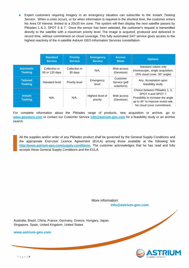
Expert customers requiring imagery in an emergency situation can subscribe to the Instant Tasking
Service. When a crisis occurs, or for when information is required in the shortest time, the customer enters
his Area Of Interest, limited to a 20x20 km zone. The system will then display the next satellite passes by
Pléiades 1 & 2, SPOT 6 & 7. Once the sensor has been selected, the customer’s request is transmitted
directly to the satellite with a maximum priority level. The image is acquired, produced and delivered in
record time, without commitment on cloud coverage. This fully automated 24/7 service gives access to the
highest reactivity of the 4-satellite Astrium GEO-Information Services constellation.
Standard
Service
Priority
Service
Emergency
Service
Access
Mode Options
Automatic
Tasking
Collection in
60 or 120 days
Collection in
30 days N/A.
Web access
(Geostore)
Standard values only
(monoscopic, single acquisition,
15% cloud cover, 30° angle)
Tailored
Tasking Standard level Priority level
Emergency
level
Customer
Service (pdf
orderform)
Any. Acceptation upon
feasibility study
Instant
Tasking N/A. N/A.
Highest level of
priority
Web access
(Geostore)
Choice between Pléiades 1, 2,
SPOT 6 and SPOT 7.
Possibility to increase the angle
up to 45° to improve revisit rate.
No cloud cover commitment.
For complete information about the Pléiades range of products, new acquisition or archive, go to
www.geostore.com or contact our Customer Service [email protected] for a feasibility study or an archive
search.
.
All the supplies and/or order of any Pléiades product shall be governed by the General Supply Conditions and
the appropriate End-User Licence Agreement (EULA) among those available at the following link
http://www.astrium-geo.com/supply-conditions. The customer acknowledges that he has read and fully
accepts these General Supply Conditions and the EULA.
More information:
Australia, Brazil, China, France, Germany, Greece, Hungary, Japan,
Singapore, Spain, United Kingdom, United States
www.astrium-geo.com