Embed Size (px)
Citation preview
GREEDY INTERSECTION-MODE ROUTING STRATEGY PROTOCOL FOR
VEHICULAR NETWORKS
MAHMOUD AHMAD SALEM AL-KHASAWNEH
UNIVERSITI TEKNOLOGI MALAYSIA
GREEDY INTERSECTION-MODE ROUTING STRATEGY PROTOCOL FOR
VEHICULAR NETWORKS
MAHMOUD AHMAD SALEM AL-KHASAWNEH
A dissertation submitted in partial fulfillment of the
requirements for the award of the degree of
Master of Science (Computer Science)
Faculty of Computer Science and Information Systems
Universiti Teknologi Malaysia
NOVEMBER 2012
iii
This dissertation is dedicated to all of my family for their endless support and
encouragement. Especially for my future wife Dita for her understanding and
support.
iv
ACKNOWLEDGEMENT
First and foremost, I would like to express heartfelt gratitude to my
supervisor Assoc. Prof. Dr. Md. Asri Ngadi for his constant support during my
study at UTM. He inspired me greatly to work in this dissertation. His willingness to
motivate me contributed tremendously to our project. I have learned a lot from him
and I am fortunate to have him as my mentor and supervisor
Besides, I would like to thank the authority of Universiti Teknologi Malaysia
(UTM) for providing me with a good environment and facilities.
v
ABSTRACT
In the recent years, the development of wireless network technology has been
improved and there are so many researches undergoing in Vehicular Ad hoc
Network. VANET has reached the greatest attention in the world. In VANET the
velocity of carriers in the vehicle is high so it is very efficient to forward data and
there are so many researchers are planned to develop routing protocol. The proposed
routing algorithm is used to simulate in the distributed environment. The main
purposes of this routing strategy are designed and develop the sustainable routing
with better efficiency and adaptability. This proposed scheme uses geographic
position based routing protocol and in that position based routing we using GpsrJ+
algorithm and it is adopted by VANET technology. Due to development of countries
the vehicle travel in non-ordered distribution, so we are using GPSR greedy mode to
forward packets and this mode fails often and it needs recovery mode or perimeter
mode. This GPSR greedy mode always fails and it is worth for forwarding packets.
So the proposed enhanced GpsrJ+ mode overcomes the disadvantage of GPSR and
GPCR. This proposed system gives good packet delivery ratio by simple
modification of the process. This system uses greedy mode on straight roads and
intersection mode on intersection and it works intelligently because it can identify
the direction of node and it effectively find the shortest path of the destination to
send data packets. Finally GprsJ+ does not need expensive planarization strategy and
it reduces hop count effectively. The unnecessary hop count and routing overload are
avoided in the enhanced proposed routing protocol.
vi
ABSTRAK
Dalam tahun-tahun kebelakangan ini, pembangunan teknologi rangkaian
wayarles telah bertambah baik dan terdapat banyak kajian yang menjalani dalam
Rangkaian kenderaan ad hoc. VANET telah mencapai perhatian yang terbesar di
dunia. Dalam VANET halaju pembawa di dalam kenderaan itu adalah tinggi jadi ia
adalah sangat berkesan untuk mengemukakan data dan terdapat begitu banyak
penyelidik merancang untuk membangunkan protokol routing. Algoritma routing
yang dicadangkan digunakan untuk mensimulasikan dalam persekitaran yang
diedarkan. Tujuan utama strategi routing ini direka dan membangunkan routing
mampan dengan kecekapan yang lebih baik dan penyesuaian. Ini skim yang
dicadangkan menggunakan kedudukan geografi berasaskan routing protokol dan
dalam kedudukan itu berdasarkan laluan kami menggunakan algoritma GpsrJ + dan
ia diguna pakai oleh teknologi VANET. Disebabkan pembangunan negara perjalanan
kenderaan dalam pengagihan bukan supaya, jadi kita menggunakan mod GPSR
tamak untuk mengemukakan paket dan mod ini gagal sering dan ia perlu mod
pemulihan atau mod perimeter. Ini mod tamak GPSR sentiasa gagal dan ia adalah
bernilai untuk penghantaran paket. Jadi yang dipertingkatkan yang dicadangkan
GpsrJ + mod mengatasi kelemahan GPSR dan GPCR. Sistem yang dicadangkan ini
memberikan nisbah penyerahan paket yang baik oleh pengubahsuaian mudah proses.
Sistem ini menggunakan mod tamak di atas jalan yang lurus dan mod persimpangan
di persimpangan dan ia berfungsi bijak kerana ia boleh mengenal pasti arah nod dan
ia berkesan mencari laluan terpendek destinasi untuk menghantar paket data.
Akhirnya GprsJ + tidak memerlukan strategi planarization mahal dan ia
mengurangkan hop mengira berkesan. Kiraan hop yang tidak perlu dan beban laluan
dielakkan dalam protokol routing dicadangkan dipertingkatkan.
vii
TABLE OF CONTENTS
CHAPTER TITLE PAGE
DECLARATION ii
DEDICATION iii
ACKNOWLEDGEMENT iv
ABSTRACT v
ABSTRAK vi
TABLE OF CONTENTS vii
LIST OF TABLES xi
LIST OF FIGURES xii
LIST OF ABBREVIATIONS xiv
1 INTRODUCTION 1
1.1 Overview 1
1.2 Problem Background 3
1.3 Research Statement 9
1.4 Research Aim 9
1.5 Research Objectives 10
1.6 Scope of the Study 10
1.7 Significance of the Study 11
1.8 Structure of Thesis 11
2 LITERATURE REVIEW 12
2.1 Introduction 12
viii
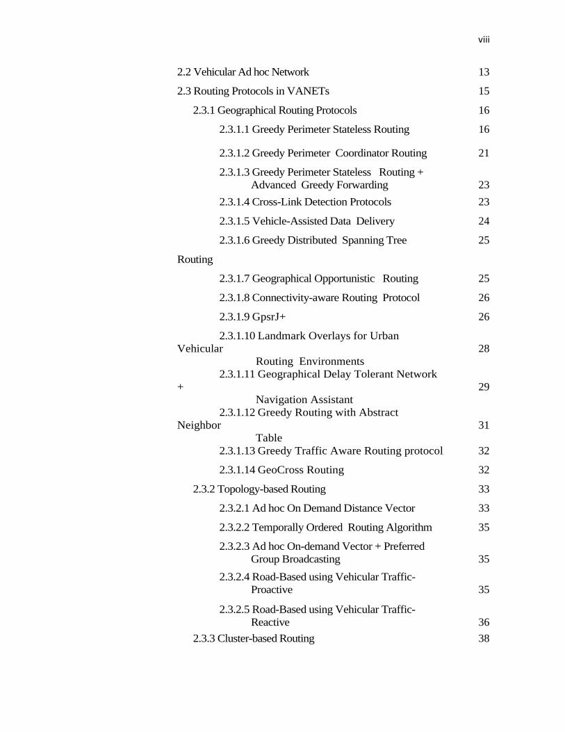
2.2 Vehicular Ad hoc Network 13
2.3 Routing Protocols in VANETs 15
2.3.1 Geographical Routing Protocols 16
2.3.1.1 Greedy Perimeter Stateless Routing 16
2.3.1.2 Greedy Perimeter Coordinator Routing 21
2.3.1.3 Greedy Perimeter Stateless Routing +
Advanced Greedy Forwarding
23
2.3.1.4 Cross-Link Detection Protocols 23
2.3.1.5 Vehicle-Assisted Data Delivery 24
2.3.1.6 Greedy Distributed Spanning Tree
Routing
25
2.3.1.7 Geographical Opportunistic Routing 25
2.3.1.8 Connectivity-aware Routing Protocol 26
2.3.1.9 GpsrJ+ 26
2.3.1.10 Landmark Overlays for Urban
Vehicular
Routing Environments
28
2.3.1.11 Geographical Delay Tolerant Network
+
Navigation Assistant
29
2.3.1.12 Greedy Routing with Abstract
Neighbor
Table
31
2.3.1.13 Greedy Traffic Aware Routing protocol 32
2.3.1.14 GeoCross Routing 32
2.3.2 Topology-based Routing 33
2.3.2.1 Ad hoc On Demand Distance Vector 33
2.3.2.2 Temporally Ordered Routing Algorithm 35
2.3.2.3 Ad hoc On-demand Vector + Preferred
Group Broadcasting
35
2.3.2.4 Road-Based using Vehicular Traffic-
Proactive
35
2.3.2.5 Road-Based using Vehicular Traffic-
Reactive
36
2.3.3 Cluster-based Routing 38
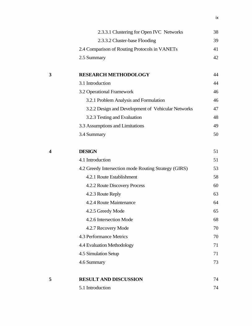
ix
2.3.3.1 Clustering for Open IVC Networks 38
2.3.3.2 Cluster-base Flooding 39
2.4 Comparison of Routing Protocols in VANETs 41
2.5 Summary 42
3 RESEARCH METHODOLOGY 44
3.1 Introduction 44
3.2 Operational Framework 46
3.2.1 Problem Analysis and Formulation 46
3.2.2 Design and Development of Vehicular Networks 47
3.2.3 Testing and Evaluation 48
3.3 Assumptions and Limitations 49
3.4 Summary 50
4 DESIGN 51
4.1 Introduction 51
4.2 Greedy Intersection mode Routing Strategy (GIRS) 53
4.2.1 Route Establishment 58
4.2.2 Route Discovery Process 60
4.2.3 Route Reply 63
4.2.4 Route Maintenance 64
4.2.5 Greedy Mode 65
4.2.6 Intersection Mode 68
4.2.7 Recovery Mode 70
4.3 Performance Metrics 70
4.4 Evaluation Methodology 71
4.5 Simulation Setup 71
4.6 Summary 73
5 RESULT AND DISCUSSION 74
5.1 Introduction 74
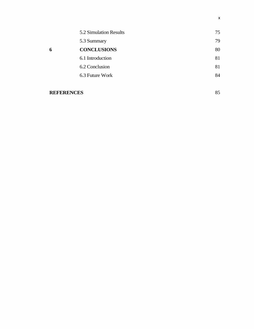
x
5.2 Simulation Results 75
5.3 Summary 79
6 CONCLUSIONS 80
6.1 Introduction 81
6.2 Conclusion 81
6.3 Future Work 84
REFERENCES 85
xi
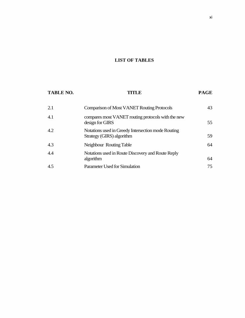
LIST OF TABLES
TABLE NO. TITLE PAGE
2.1 Comparison of Most VANET Routing Protocols 43
4.1 compares most VANET routing protocols with the new
design for GIRS
55
4.2 Notations used in Greedy Intersection mode Routing
Strategy (GIRS) algorithm
59
4.3 Neighbour Routing Table 64
4.4 Notations used in Route Discovery and Route Reply
algorithm
64
4.5 Parameter Used for Simulation 75
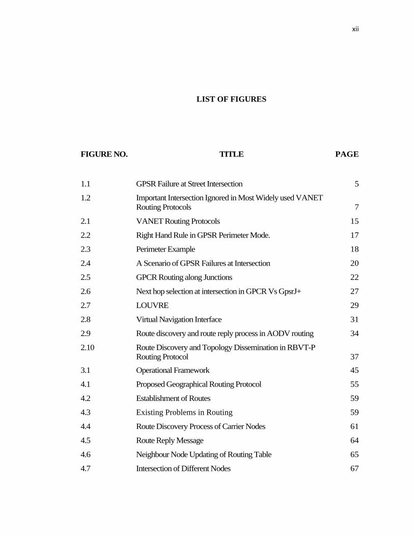
xii
LIST OF FIGURES
FIGURE NO. TITLE PAGE
1.1 GPSR Failure at Street Intersection 5
1.2 Important Intersection Ignored in Most Widely used VANET
Routing Protocols
7
2.1 VANET Routing Protocols 15
2.2 Right Hand Rule in GPSR Perimeter Mode. 17
2.3 Perimeter Example 18
2.4 A Scenario of GPSR Failures at Intersection 20
2.5 GPCR Routing along Junctions 22
2.6 Next hop selection at intersection in GPCR Vs GpsrJ+ 27
2.7 LOUVRE 29
2.8 Virtual Navigation Interface 31
2.9 Route discovery and route reply process in AODV routing 34
2.10 Route Discovery and Topology Dissemination in RBVT-P
Routing Protocol
37
3.1 Operational Framework 45
4.1 Proposed Geographical Routing Protocol 55
4.2 Establishment of Routes 59
4.3 Existing Problems in Routing 59
4.4 Route Discovery Process of Carrier Nodes 61
4.5 Route Reply Message 64
4.6 Neighbour Node Updating of Routing Table 65
4.7 Intersection of Different Nodes 67
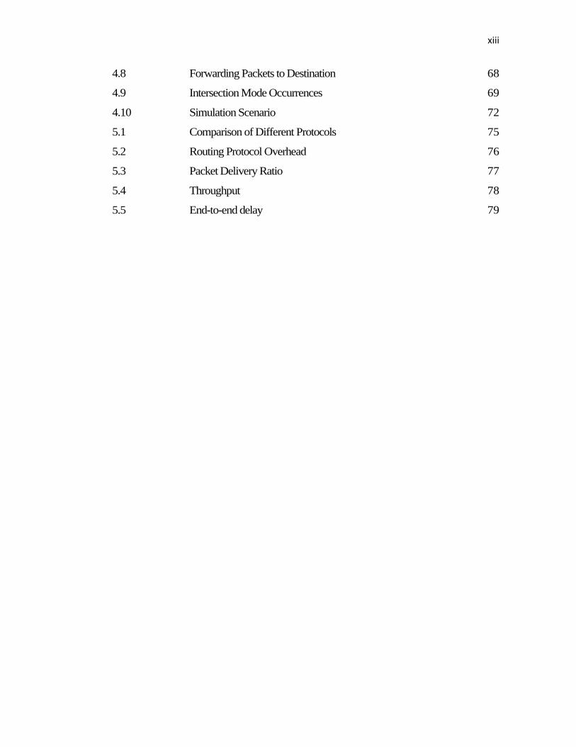
xiii
4.8 Forwarding Packets to Destination 68
4.9 Intersection Mode Occurrences 69
4.10 Simulation Scenario 72
5.1 Comparison of Different Protocols 75
5.2 Routing Protocol Overhead 76
5.3 Packet Delivery Ratio 77
5.4 Throughput 78
5.5 End-to-end delay 79
xiv
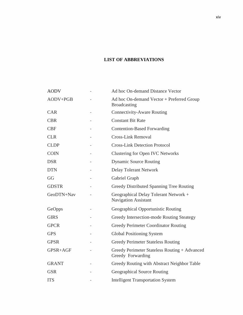
LIST OF ABBREVIATIONS
AODV - Ad hoc On-demand Distance Vector
AODV+PGB - Ad hoc On-demand Vector + Preferred Group
Broadcasting
CAR - Connectivity-Aware Routing
CBR - Constant Bit Rate
CBF - Contention-Based Forwarding
CLR - Cross-Link Removal
CLDP - Cross-Link Detection Protocol
COIN - Clustering for Open IVC Networks
DSR - Dynamic Source Routing
DTN - Delay Tolerant Network
GG - Gabriel Graph
GDSTR - Greedy Distributed Spanning Tree Routing
GeoDTN+Nav - Geographical Delay Tolerant Network +
Navigation Assistant
GeOpps - Geographical Opportunistic Routing
GIRS - Greedy Intersection-mode Routing Steategy
GPCR - Greedy Perimeter Coordinator Routing
GPS - Global Positioning System
GPSR - Greedy Perimeter Stateless Routing
GPSR+AGF - Greedy Perimeter Stateless Routing + Advanced
Greedy Forwarding
GRANT - Greedy Routing with Abstract Neighbor Table
GSR - Geographical Source Routing
ITS - Intelligent Transportation System
xv
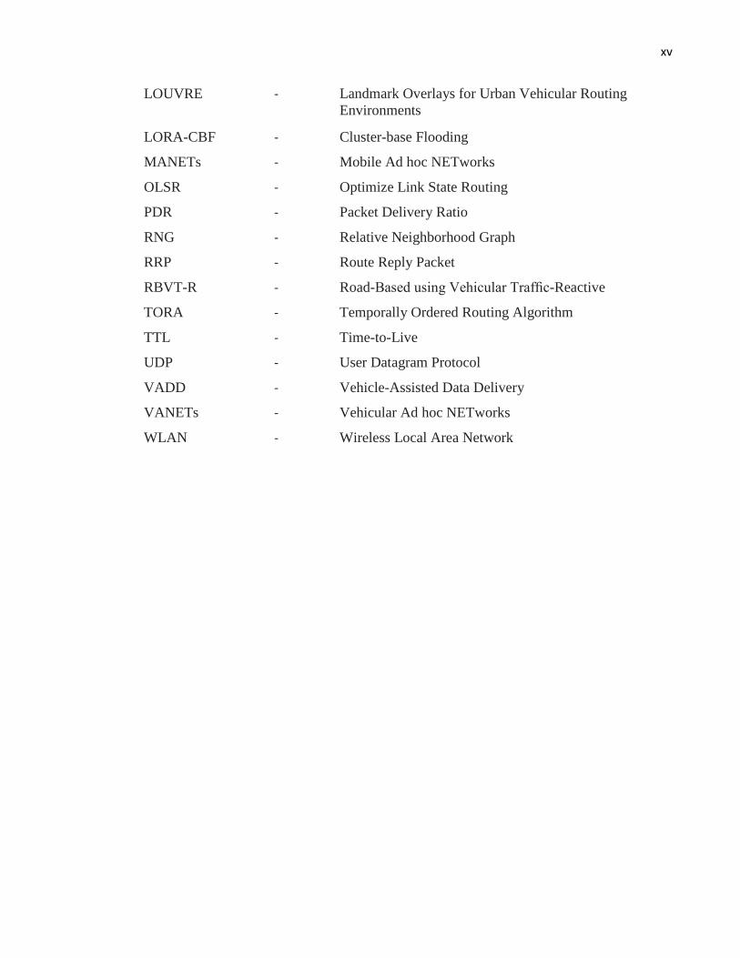
LOUVRE - Landmark Overlays for Urban Vehicular Routing
Environments
LORA-CBF - Cluster-base Flooding
MANETs - Mobile Ad hoc NETworks
OLSR - Optimize Link State Routing
PDR - Packet Delivery Ratio
RNG - Relative Neighborhood Graph
RRP - Route Reply Packet
RBVT-R - Road-Based using Vehicular Traffic-Reactive
TORA - Temporally Ordered Routing Algorithm
TTL - Time-to-Live
UDP - User Datagram Protocol
VADD - Vehicle-Assisted Data Delivery
VANETs - Vehicular Ad hoc NETworks
WLAN - Wireless Local Area Network
CHAPTER 1
INTRODUCTION
1.1 Overview
Vehicular Ad-Hoc Networks, (VANET), are a particular kind of Mobile Ad Hoc
Network, (MANET), in which vehicles act as nodes and each vehicle is equipped
with transmission capabilities which are interconnected to form a network. The
topology created by vehicles is usually very dynamic and significantly non-
uniformly distributed. In order to transfer information about these kinds of networks,
standard MANET routing algorithms are not appropriate (Lee et al., 2010b).
The availability of navigation systems on each vehicle makes it aware of its
geographic location as well as its neighbours. However, a particular kind of routing
approach, called Geographic Routing, becomes possible where packets are
forwarded to a destination simply by choosing a neighbour who is geographically
closer to that destination. With the rapid growth of vehicles and roadside traffic
monitors, the advancement of navigation systems, and the low cost of wireless
network devices, promising peer-to-peer (P2P) applications and externally-driven
services to vehicles became available. For this purpose, the Intelligent Transportation
Systems (ITS) have proposed the Wireless Access in Vehicular Environments
(WAVE) standards that define an architecture that collectively enables vehicle-to-
2
vehicle (V2V) and vehicle-to-infrastructure (V2I) wireless communications (ITS,
2012).
According to architectures of network, VANET can be divided into three
categories, the first of which is the Wireless Wide Area Network (WWAN) in which
the access points of the cellular gateways are fixed in order to allow direct
communication between the vehicles and the access points. However, these access
points require costly installation, which is not feasible. The second category is the
Hybrid Wireless Architecture in which WWAN access points are used at certain
points while an ad hoc communication provides access and communication in
between those access points. The third and final category is the Ad Hoc V2V
Communication which does not require any fixed access points in order for the
vehicles to communicate. Vehicles are equipped with wireless network cards, and a
spontaneous setting up of an ad hoc network can be done for each vehicle (Li and
Wang, 2007). This study will focus on studying ad hoc V2V communication
networks, which are also known as VANETs.
The purpose of VANET is to allow wireless communication between vehicles on
the road including the roadside wireless sensors, enabling the transfer of information
to ensure driving safety and planning for dynamic routing, allowing mobile sensing
as well as providing in-car entertainment. As VANETs have unique characteristics
which include dynamic topology, frequent disconnection of the networks, and
varying environments for communication, the routing protocols for traditional
MANET such as Ad hoc On-demand Distance Vector (AODV) (Perkins and Royer,
1999) are not directly usable for VANETs.
Researchers have developed a variety of efficient routing protocols for VANETs
including Greedy Perimeter Stateless Routing (GPSR) (Karp and Kung, 2000);
Greedy Perimeter Coordinator Routing (GPCR) (Lochert et al., 2005); and GpsrJ+
(Lee et al., 2007). The current issue, however, is that the range of the wireless
3
sensors on vehicles is limited to a few hundred meters at most and the traffic
conditions in a vehicular urban environment often change dynamically. Other than
that, VANET routing protocols also face other problems including the issue of
unstructured roads, the difference in the sizes of the intersections in a certain area,
the sharp curves of the roads, uneven slopes, and other obstacles such as large
buildings, traffic lights, trees, and sign boards. As it is impractical to spend
excessively on rebuilding or restructuring the existing roads in urban environments, a
routing protocol for the purpose of a larger distance of data communication in one-
to-one and one-to-many transfers specifically for VANETs need to be developed.
This study will focus on the current challenges in the research of geographical
routing protocols for real-time vehicular networks in urban environments.
1.2 Problem Background
Although it is considered not feasible to use the known end-to-end wireless
communication which uses multi-hop to represent the highly mobile nodes available
in VANETs, there are various mobile communications capable of supporting
networks for vehicular purposes, fulfilling the needs to dynamically route file
transfer and sharing, a system to disseminate real-life traffic alerts as well as context-
free advertisements (Dashtinezhad et al., 2004; Nandan et al., 2005; Riva et al.,
2007; Zhou et al., 2005). Therefore, a VANET routing protocol which is capable of
handling any number of nodes in an urban environment needs to be developed to
allow a higher delivery ratio for packet transfers while lowering the end-to-end
delay. This study focuses on addressing a known challenge in providing better
services in vehicular networks for urban environments: the problem of decision-
making at intersections and how to forward messages when an intersection is
reached. This problem often occurs in any vehicular network in real urban
environments and can directly affect the performance of the network.
4
VANETs require geographical routing protocols that utilize the Global
Positioning System (GPS) to locate the next available node on the network (Bose et
al., 2001; Karp and Kung, 2000; Kuhn et al., 2003; Lee et al., 2010a; Lochert et al.,
2005). The use of GPS allows a more dynamic form of communication in which
routes do not need to be established between the source nodes and the destination
nodes before the data can be forwarded. GPS obtains the neighbour nodes by
selecting the next best hop. The Greedy Perimeter Stateless Routing (GPSR) by Karp
and Kung, ( 2000) is an example of a popular and widely used geographical routing
protocol in which a route is established between the source node and the destination
node through the utilization of the greedy and the perimeter modes within the
network. Greedy forwarding is first used for the data forwarding in which the packet
is forwarded to the node closest to the destination node. Due to the limitations of the
radio range within the network, the local maximum of the network may be reached
through the use of this mode and data may not be successfully transferred. The
GPSR then uses the perimeter mode to forward the packet to a neighbour node
closest to the destination node according to the right hand rule, to recover from the
encounter with the local maximum. A planar graph is needed in this mode in order to
avoid routing loops. Cross-edges can be removed from the graph with the use of two
algorithms: Relative Neighborhood Graph (RNG) and Gabriel Graph (GG). These
planarization algorithms assume that the links between any two nodes exist if and
only if the nodes are within a certain threshold distance. The application of GPSR is
proven to provide better performance within a typical urban environment, where a
high ratio average delivery and low average delay can be achieved. However, other
than neglecting to consider problems such as intersections, network partitioning and
cross-links, the main problem in the use of the GPSR is that a direct link cannot be
established between two nodes at an intersection as GPSR does not take into account
large obstacles in an urban environment (Kim et al., 2005b; Lee et al., 2010a; Li and
Wang, 2007). Figure 1.1 shows the failure of GPSRs: Figure 1.1(a) the relative
neighborhood graph (RNG) is a planar topology used by GPSR, which consists of a
link N1 N2 if the intersection of two circles centered at N1 and N2 with radius N1 N2
(shaded area) does not contain any other nodes. In Figure 1.1(b) the link N1 N2 is
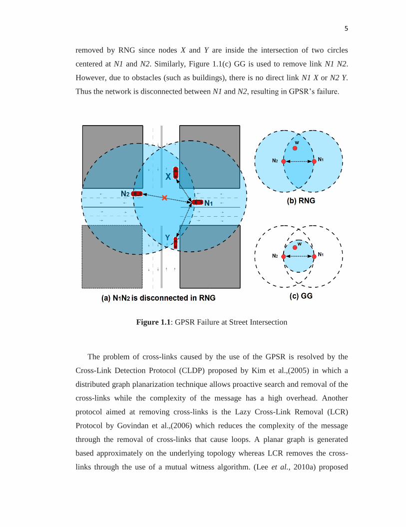
5
removed by RNG since nodes X and Y are inside the intersection of two circles
centered at N1 and N2. Similarly, Figure 1.1(c) GG is used to remove link N1 N2.
However, due to obstacles (such as buildings), there is no direct link N1 X or N2 Y.
Thus the network is disconnected between N1 and N2, resulting in GPSR’s failure.
Figure 1.1: GPSR Failure at Street Intersection
The problem of cross-links caused by the use of the GPSR is resolved by the
Cross-Link Detection Protocol (CLDP) proposed by Kim et al.,(2005) in which a
distributed graph planarization technique allows proactive search and removal of the
cross-links while the complexity of the message has a high overhead. Another
protocol aimed at removing cross-links is the Lazy Cross-Link Removal (LCR)
Protocol by Govindan et al.,(2006) which reduces the complexity of the message
through the removal of cross-links that cause loops. A planar graph is generated
based approximately on the underlying topology whereas LCR removes the cross-
links through the use of a mutual witness algorithm. (Lee et al., 2010a) proposed
6
GeoCross, an event-driven geographical routing protocol which can dynamically
remove cross-links to avoid the problem of loops. Instead of the usual use of planar
graphs, GeoCross uses urban maps with natural planar features. Compared to GPSR
and GPCR, GeoCross offers a higher ratio of packet delivery and lower average
delay. However, none of the previous protocols attempt to solve the problem of how
to forward messages when the intersection is reached.
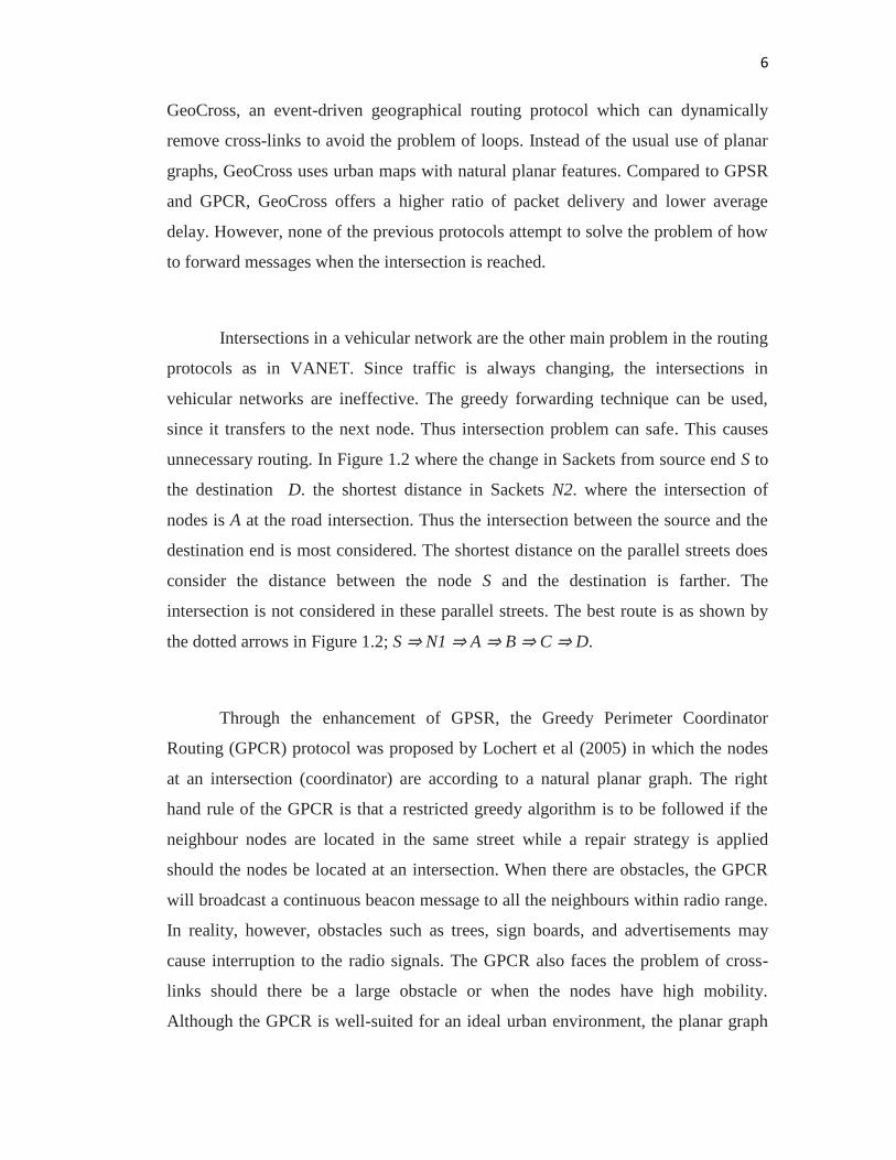
Intersections in a vehicular network are the other main problem in the routing
protocols as in VANET. Since traffic is always changing, the intersections in
vehicular networks are ineffective. The greedy forwarding technique can be used,
since it transfers to the next node. Thus intersection problem can safe. This causes
unnecessary routing. In Figure 1.2 where the change in Sackets from source end S to
the destination D. the shortest distance in Sackets N2. where the intersection of
nodes is A at the road intersection. Thus the intersection between the source and the
destination end is most considered. The shortest distance on the parallel streets does
consider the distance between the node S and the destination is farther. The
intersection is not considered in these parallel streets. The best route is as shown by
the dotted arrows in Figure 1.2; S ⇒ N1 ⇒ A ⇒ B ⇒ C ⇒ D.
Through the enhancement of GPSR, the Greedy Perimeter Coordinator
Routing (GPCR) protocol was proposed by Lochert et al (2005) in which the nodes
at an intersection (coordinator) are according to a natural planar graph. The right
hand rule of the GPCR is that a restricted greedy algorithm is to be followed if the
neighbour nodes are located in the same street while a repair strategy is applied
should the nodes be located at an intersection. When there are obstacles, the GPCR
will broadcast a continuous beacon message to all the neighbours within radio range.
In reality, however, obstacles such as trees, sign boards, and advertisements may
cause interruption to the radio signals. The GPCR also faces the problem of cross-
links should there be a large obstacle or when the nodes have high mobility.
Although the GPCR is well-suited for an ideal urban environment, the planar graph
7
is not usable if there are no nodes, such as in the case of node A in Figure 1.2.
GpsrJ+ Lee et al., ( 2007) improves the ratio of packet delivery of the current GPCR
protocol through the prediction of road segments.
Figure 1.2: Important Intersection Ignored in Most Widely used VANET Routing
Protocols
The prediction is done to decide which neighbours at the intersections the packet
should be forwarded to next. GpsrJ+ also uses natural planar features of maps in an
urban environment and the hop count in the perimeter is reduced, allowing quicker
8
return to the greedy mode. Observation by Jarupan and Ekici (2010) stated that this
protocol is not efficient for use in the vehicular networks of a typical urban
environment as the neighbour management around an intersection is considered
intensive.
RBVT-R is the name of Road-Based Used Vehicular Traffic information, as
Nzouonta et al., ( 2009) proposed and which contains road intersections. It features
high probability and network connectivity. Instead of sending frequent messages,
RBVT-R introduces a new method to reduce the path sensitivity. It has several
parameter values. RBVT-R works in its own environment and does not implement in
real VANET where there is always a change in network and traffic conditions.
In a geo-proactive overlay routing called Landmark Overlays for Urban
Vehicular Routing Environments (LOUVRE) proposed by Lee et al (2008) creates
overlay links on top of an urban topology. In LOUVRE, the nodes at intersections
are defined as landmarks and the overlay links are only possible if there is enough
traffic density between intersections. LOUVRE’s guaranteed multi-hop routing is a
suitable method for avoiding dead-end roads. Jerbi et al.,(2009) also proposed an
intersection-based geographically greedy traffic-aware routing (GyTAR) protocol to
find the best routes in urban environments. GyTAR creates routes from source to
destination based on a sequence of connected intersections. Two parameters,
including change in vehicular traffic information and the remaining distance from the
destination, are used to define a best route. GyTAR also uses an improved greedy
forwarding mechanism to forward data packets on the road segments. However, if
there is no node at an intersection, the packet can not be forwarded and the
performance of LOUVRE and GyTAR are affected as data packets are dropped and
there is higher end-to-end delay.
9
1.3 Problem Statement
In order to achieve better performance in vehicular communication, the
problems regarding intersections need to be handled to improve the transfer of real-
time vehicle-to-vehicle data. Although VANETs have proven to be promising for
communication in urban environments, VANETs need to be able to provide higher
delivery ratios while minimizing delay of all the applications in the networks.
“How to improve the decision for next node selection at intersections
in Vehicular Networks”
Therefore, this study needs to answer the following research question:
How to develop a geographical routing protocol that is capable of making
better routing decisions at intersections to significantly improve the performance of
VANET?
1.4 Research Aim
This study aims to develop a geographical routing protocol capable of efficiently
handling the problems regarding intersections in real-time vehicular urban
environments
.
10
1.5 Research Objectives
The objectives of this research are:
i To enhance a geographical routing protocol which is capable of making
better decisions at intersections.
ii To develop an enhancement of a geographical routing protocol that reduces
average delay.
iii To evaluate the performance of the proposed routing protocol as compared to
widely-used VANET routing protocols (GPSR, GPCR, GpsrJ+) regarding
average delivery ratios and end-to-end delay.
1.6 Scope of the study
The scope of the study covers the following
i The assumed scenario is that vehicles are able to move in a two-way urban
environment where no network infrastructure or centralized traffic control is
considered.
ii Forwarding of the data packets can be done freely if the next node within the
vehicles communication range is available.
11
1.7 Significance of the Study
In order to achieve further advancement in the technology of mobile
communication, research in the vehicular industry has been done with special
emphasis in the areas of routing and routing management, information security, and
enabling communication between vehicle-to-vehicle and vehicle-to-infrastructure, as
well as technological deployments. In the area of routing, however, real-life urban
environments cannot be properly reflected by the currently implemented routing
protocols for VANETs. Therefore, this study is done in order to solve the problems
regarding roads with intersections by addressing the issues which arise from packet
transfers on the road and at intersections. The study focuses on improving VANETs
in terms of routing and data forwarding where the characteristics of VANETs are
incorporated into the design of a protocol for urban environments.
1.8 Structure of the Thesis
The remainder of the thesis is structured as follows: Chapter 2, Literature
Review, provides extensive review of highly related literature regarding
geographical routing protocols of urban environments. Chapter 3 presents and
describes the research methodology used for the study, including the operational
framework of the design and the development of vehicular networks. Chapter 4
provides the formal introduction of the proposed routing protocol through the design,
and examples of routing protocols as well as analysis of the performance. Finally,
Chapter 5 provide the conclusion and suggestions for future work.
REFERENCES
Bernsen, J. and Manivannan, D. (2009). Unicast routing protocols for vehicular
adhocnetworks: Acriticalcomparisonandclassifcation. Pervasive and Mobile
Computing. 5(1), 1 –18. ISSN 1574-1192.
Blum, J., Eskandarian, A. and Hoffman, L. (2003). Mobility management in IVC
networks. In Intelligent Vehicles Symposium, 2003. Proceedings. IEEE. 150
– 155.
Bose, P., Morin, P., Stojmenovic, I. and Urrutia, J. (2001). Routing with Guaranteed
DeliveryinAd Hoc WirelessNetworks. Wireless Networks. 7(6),609–616.
Dashtinezhad, S., Nadeem, T., Dorohonceanu, B. and Borcea, C. (2004).
TraffcView: ADriverAssistantDeviceforTraffcMonitoringBased onCar-to-
Car Communication. In In IEEE Semiannual Vehicular Technology. May.
17–19.
Fubler, H., Mauve, M., Hartenstein, H., Vollmer, D. and Kasemann, M. (2002). A
comparison of routing strategies in vehicular ad-hoc networks. Technical
report. UniversittMannheimMarch.
ITS(2012). ITS Standards. Retrievableat http://www.standards.its.dot. gov/about.asp.
Jacquet, P., Muhlethaler, P., Clausen, T., Laouiti, A., Qayyum, A. and Viennot, L.
(2001). Optimized link state routing protocol for ad hoc networks. In Multi
Topic Conference, 2001. IEEE INMIC 2001. Technology for the 21st
Century. Proceedings. IEEE International.62 –68.
Jerbi, M., Senouci, S.-M., Rasheed, T. and Ghamri-Doudane, Y. (2009). Towards
Effcient Geographic Routing in Urban Vehicular Networks. Vehicular
Technology, IEEE Transactions on. 58(9),5048 –5059.
83
Johnson,D. B. and Maltz, D. A. (1996). Dynamic Source Routing in Ad Hoc
Wireless Networks. KluwerAcademic Publishers.
Karp,B.andKung,H.T.(2000). GPSR:greedyperimeterstatelessroutingforwireless
networks. InMobiCom ’00: Proceedings of the 6th annual international
conference on Mobile computing and networking.New York,NY, USA:
ACM, 243–254.
Kim, Y.-J., Govindan, R., Karp, B. and Shenker, S. (2005a). Geographic routing
made practical. In Proceedings of the 2nd conference on Symposium on
Networked Systems Design & Implementation -Volume 2. NSDI’05.
Berkeley, CA, USA: USENIX Association,217–230.
Kim, Y.-J., Govindan, R., Karp, B. and Shenker, S. (2005b). On the pitfalls of
geographicfacerouting. In Proceedings of the 2005 joint workshop on
Foundations of mobile computing. DIALM-POMC ’05. NewYork, NY,
USA: ACM,34–43.
Kuhn, F., Wattenhofer, R., Zhang, Y. and Zollinger, A. (2003). Geometric ad-hoc
routing: of theory and practice. In PODC ’03: Proceedings of the twenty-
second annual symposium on Principles of distributed computing. New York,
NY, USA: ACM, 63–72.
Lee, K., Haerri, J., Lee, U. and Gerla, M. (2007). Enhanced Perimeter Routing for
Geographic Forwarding Protocols in Urban Vehicular Scenarios. In
Globecom Workshops, 2007 IEEE. nov. 1 –10.
doi:10.1109/GLOCOMW.2007.4437832.
Lee, K., Le, M., Harri, J. and Gerla, M. (2008). LOUVRE: Landmark Overlays for
UrbanVehicularRoutingEnvironments. InVehicular Technology Conference,
2008. VTC 2008-Fall. IEEE 68th.1–5.
Lee, K. C., Cheng, P.-C. and Gerla, M. (2010a). GeoCross: A geographic routing
protocol in the presence of loops in urban scenarios. Ad Hoc Networks. 8(5),
474 –
488. ISSN 1570-8705. Vehicular Networks.
Lee, K. C., Lee, U. and Gerla, M. (2010b). Survey of Routing Protocols in Vehicular
Ad Hoc Networks. IGI Global.
84
Lee, U., Zhou, B., Gerla, M., Magistretti, E., Bellavista, P. and Corradi, A. (2006).
Mobeyes: smart mobs for urban monitoring with a vehicular sensor network.
Wireless Communications, IEEE. 13(5), 52 –57.
Leong,B.,Liskov,B.andMorris,R.(2006). Geographicroutingwithoutplanarization. In
NSDI’06: Proceedings of the 3rd conference on Networked Systems Design
& Implementation.Berkeley,CA, USA: USENIX Association,25–25.
Li,F. andWang,Y. (2007). Routinginvehicularadhocnetworks: Asurvey.Vehicular
Technology Magazine, IEEE. 2(2), 12 –22.
Liu,C. G.,Liu,G.,sungLee,B.,chongSeet,B.,hengFoh,C. andkeeLee,K. (2004).
ARoutingStrategyforMetropolisVehicular. In In Proc. International
Conference on Information Networking. 533–542.
Lochert, C., Mauve,M., Fubler, H. and Hartenstein,H. (2005). Geographicroutingin
city scenarios. SIGMOBILE Mob. Comput. Commun. Rev. 9, 69–72. ISSN
15591662.
Namboodiri,V.,Agarwal,M. andGao,L. (2004). Astudyonthefeasibilityofmobile
gateways for vehicular ad-hoc networks. In VANET ’04: Proceedings of the
1st ACM international workshop on Vehicular ad hoc networks.66–75.
Nandan, A., Das, S., Pau, G., Gerla, M. and Sanadidi, M. (2005). Co-operative
downloading in vehicular ad-hoc wireless networks. In Wireless On-demand
Network Systems and Services. jan. 32 – 41.
Naumov,V., Baumann,R. and Gross,T. (2006). Anevaluationofinter-vehiclead hoc
networks based on realistic vehicular traces. In MobiHoc ’06: Proceedings of
the 7th ACM international symposium on Mobile ad hoc networking and
computing. New York, NY,USA: ACM, 108–119.
Nzouonta, J., Rajgure, N., Wang, G. and Borcea, C. (2009). VANET Routing on City
Roads UsingReal-Time Vehicular Traffc Information. Vehicular Technology,
IEEE Transactions on. 58(7), 3609 –3626.
Perkins, C. and Royer, E. (1999). Ad-hoc on-demand distance vector routing. In
Mobile Computing Systems and Applications.90 –100.
85
Perkins, C. E. and Bhagwat, P. (1994). Highly dynamic Destination-Sequenced
Distance-Vector routing (DSDV) for mobile computers. SIGCOMM Comput.
Commun. Rev. 24(4), 234–244.
Riva, O., Nadeem, T., Borcea, C. and Iftode, L. (2007). Context-Aware Migratory
Services in Ad Hoc Networks. Mobile Computing, IEEE Transactions on.
6(12), 1313 –1328.
Santos, R. A., Edwards, A., Edwards, R. M. and Seed, N. L. (2005). Performance
evaluation of routing protocols in vehicular ad hoc networks. Int. J. Ad Hoc
Ubiquitous Comput. 1(1/2), 80–91.
Schnaufer, S. and Effelsberg, W. (2008). Position-based unicast routing for city
scenarios. InWorld of Wireless, Mobile and Multimedia Networks, 2008.
WoWMoM 2008. 2008 International Symposium on a.1 –8.
WAVE(2010). Wireless Acess for Vehicular Environment (WAVE).
Zhou, P., Nadeem, T., Kang, P., Borcea, C. and Iftode, L. (2005). EZCab: A Cab
Booking Application Using Short-Range Wireless Communication. In
Pervasive Computing and Communications. mar. 27 –38.