Embed Size (px)
Citation preview
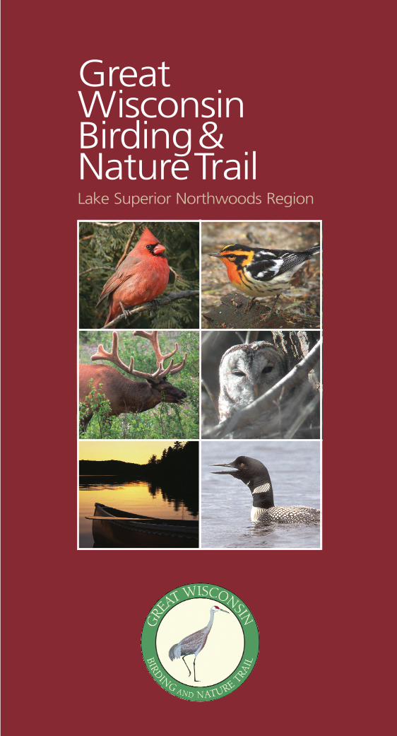
GreatWisconsinBirding&NatureTrailLake Superior Northwoods Region

WelcomeWelcome to Wisconsin where a wonderful
world of wildlife watching awaits you.Environmental tourism has become an
important part of our diverse mix of outdoorrecreation. Extensive wetlands, millions ofacres of wild places, a broad range of naturalhabitat, and a commitment to environmentalstewardship have made Wisconsin an out-standing regional birding opportunity. Morethan any other state in the Great Lakes basin,Wisconsin is positioned to promote and enjoythis popular activity.
To that end, we have launched the GreatWisconsin Birding and Nature Trail. This proj-ect divides the state into five wildlife-viewingregions. Driving trails, linking importantwildlife sites within each region, are beingdeveloped. Over five years, the program willproduce a series of birding guides to theseregions – one each year. This is the first, aguide to the Lake Superior/NorthwoodsRegion.
We hope you enjoy it.
Jim Doyle, Governor
11
ContentsIntroduction __________________________________ 2Using the Guide________________________________ 3Code of Ethics ________________________________ 3Northwoods Region Map ________________________ 4-5Waypoint Index ________________________________ 6-7County Profiles
Ashland County ____________________________ 8-10Barron County______________________________ 11-13Bayfield County ____________________________ 14-19Burnett County ____________________________ 20-23Douglas County ____________________________ 24-28Florence County ____________________________ 29-31Forest County ______________________________ 32-34Iron County ________________________________ 35-38Langlade County____________________________ 39-41Lincoln County ____________________________ 42-44Oneida County ____________________________ 45-47Polk County________________________________ 48-50Price County ______________________________ 51-53Rusk County ______________________________ 54-55Sawyer County ____________________________ 56-58Taylor County ______________________________ 59-63Vilas County ______________________________ 63-66Washburn County __________________________ 67-69
More Sources of Tourism Information ______________ 72
22
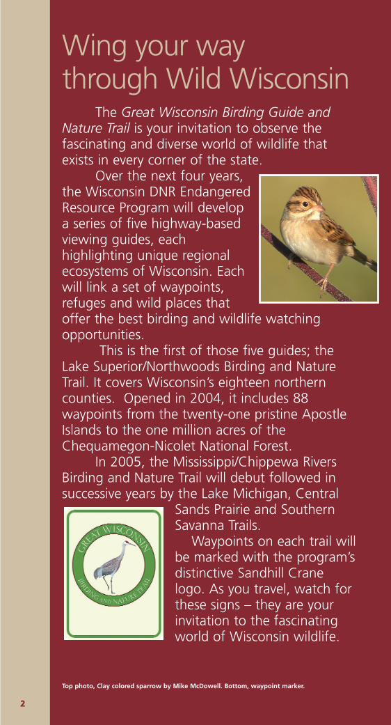
Wing your waythrough Wild Wisconsin
The Great Wisconsin Birding Guide andNature Trail is your invitation to observe thefascinating and diverse world of wildlife thatexists in every corner of the state.
Over the next four years,the Wisconsin DNR EndangeredResource Program will developa series of five highway-basedviewing guides, eachhighlighting unique regionalecosystems of Wisconsin. Eachwill link a set of waypoints,refuges and wild places thatoffer the best birding and wildlife watchingopportunities.
This is the first of those five guides; theLake Superior/Northwoods Birding and NatureTrail. It covers Wisconsin’s eighteen northerncounties. Opened in 2004, it includes 88waypoints from the twenty-one pristine ApostleIslands to the one million acres of theChequamegon-Nicolet National Forest.
In 2005, the Mississippi/Chippewa RiversBirding and Nature Trail will debut followed insuccessive years by the Lake Michigan, Central
Sands Prairie and SouthernSavanna Trails.
Waypoints on each trail willbe marked with the program’sdistinctive Sandhill Cranelogo. As you travel, watch forthese signs – they are yourinvitation to the fascinatingworld of Wisconsin wildlife.
Top photo, Clay colored sparrow by Mike McDowell. Bottom, waypoint marker.
Using the GuideInformation for this guide was gathered locally from
Wisconsin DNR and federal Forest Service personnel, from nat-uralists, birders, and a range of wildlife enthusiasts. Each sitewas nominated locally and evaluated as part of the regionalproject.
Site information includes a contact phone number,driving directions, a small locator map, a description of theproject, common and rare birds and wildlife, and a Web site ifavailable. Except as noted, admission to these properties isfree. Hours are included, even though most properties areopen 24/7.
As you would expect, most of these waypoints areremote, wild locations. While every effort has been made toprovide accurate driving instructions, we recommend that youbring a county map or gazetteer to help in finding these sites.Other prudent equipment would include a compass, flashlight,water, a granola bar, insect repellant, and a good pair of walk-ing/hiking shoes.
Code of EthicsThe Great Wisconsin Birding and Nature Trail is your gateway
to the natural world of Wisconsin. The Code of Ethics serves toguide you as you seek your favorite waypoint sites across thestate.
● Treat birds and other animals with respect, never disturbingor collecting anything in their habitat.
● Trails, roads and paths found at the sites provide goodaccess to the property. Avoid leaving them unless you are ina wilderness area.
● Wisconsin has strict trespass laws. Private property does nothave to be posted or fenced in Wisconsin. Ask permission ifyou want to enter private land. Know where you are – payattention to posted property boundary signs.
● Dogs must be leashed on all state lands during the bird-nest-ing season from April 15 through July 31.
● Lead by example. Leave the property litter-free and in goodcondition for the next traveler.
● Give nature a voice. Thank the property owner, manager orstaff person for the opportunity to enjoy nature at their site.
33
44
BAYFIELD
ASHLAND
SAWYER
DOUGLAS
WASHBURN
BURNETT
RUSKPOLK
BARRON
TAY
ST. CROIX
DUNN
CHIPPEWA
CPIERCE
Hayward
SuperiorBayfield
St. Paul
Eau Claire
Chippewa
OweWithee
Prescott
River Falls
EllsworthElmwood Downsville
Menomonie
Hudson
Somerset
New Richmond
Osceola
St. CroixFalls
Turtle Lake
Knapp
Luck
Amery
Grantsburg Siren
Webster
Danbury
Cumberland
Rice Lake
CameronBarron
ShellLake
Spooner
Trego
Minong
Gordon
Solon Springs
Poplar
Brule Iron River
La Pointe
Red CliffPort Wing
Drummond
Cable
Odanah
Ashland
BloomerCornell Gilman
M
Melle
GlidClam Lake
WinterOjibwa
Couderay
Radisson
Stone LakeHertel
Holcombe
Cadott
Ladysmith
Ph
Bruce
Duluth
St.
Cro
ix
River
ChippewaFlowage
Apostle Isla
Washburn
Flam
beau
Rive
r
M I N N E S O T A
Chippewa Falls
70
64
7777
65 27
27
27
13
13
8
2
2
63
8
61
70
35
46
35
61
53
53
63
63
53
10
94
35
3
2
4
5
76
8
10
9
11
1
14
16
15
12
13
17
1819
20 21
22
23
25
27
28
30
29
2624
60 62
61
59
64
6869
67
70
71
72
73
77
78
8688
85
87
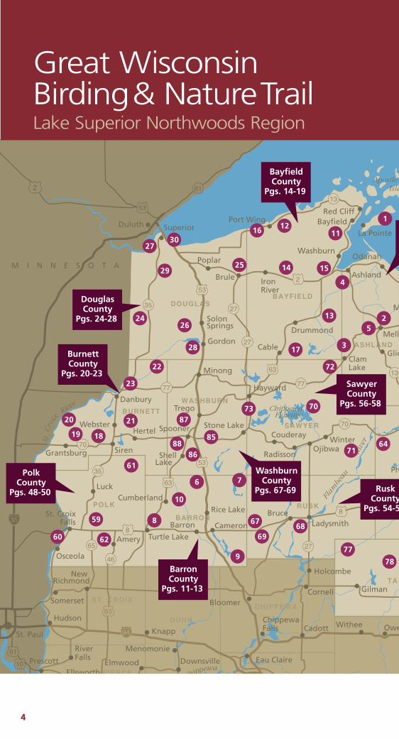
BayfieldCounty
Pgs. 14-19
DouglasCounty
Pgs. 24-28
BurnettCounty
Pgs. 20-23
PolkCounty
Pgs. 48-50
BarronCounty
Pgs. 11-13
RuskCounty
Pgs. 54-5
WashburnCounty
Pgs. 67-69
SawyerCounty
Pgs. 56-58
Great WisconsinBirding& NatureTrailLake Superior Northwoods Region
55
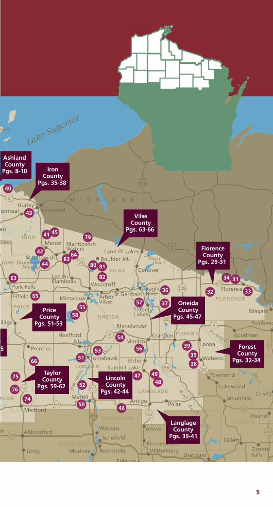
IRON
YLOR
MENOMINEE
FOREST
LINCOLN
LANGLADE
FLORENCE
MARINETTE
OCONTO
ONEIDA
VILAS
MARATHON
MARATHON
PRICE
Wis
cons
in
Ri
ver
Wausau
Rhinelander
Minocqua
EagleRiver
Lake Superior
River
Peshtigo
Riv e r
Wolf
Schofield
RothschildMosinee
Elderon
WittenbergBirnamwood
Aniwa
Antigo
Unity
Abbotsforden
Medford
MerrillPolar
Summit LakeElcho
Monico
ThreeLakes
Conover
Land O' Lakes
Woodruff
Lac duFlambeau
Manitowish Waters
Manitowish Boulder Jct.
Mercer
HurleyIronwoodontreal
en
dden
Fifield
Park Falls
Prentice
illips
Tomahawk
HeaffordJct.
Mountain
Lakewood
Townsend
Wabeno
Laona
Goodman
Pembine
Crivitz
Pound
OcontoFalls
Gillett
Shawano
Niagara
Florence
Lac Vieux DesertTurtle Flambeau
Flowage
ands
Crandon
Arbor Vitae
St.Germain
M I C H I G A N
64
29
64
13
70
32
32
55
139
8
2
2
51
8
51
45
45
141
141
39
31
32
34
33
35
37
36
39
38
44
45
42
41
43
40
47 4948
4650
5153
52
57
58
54
56
55
65
63
66
76
75
74
79
80 81
82
8384
AshlandCounty
Pgs. 8-10
y5
TaylorCounty
Pgs. 59-62 LincolnCounty
Pgs. 42-44
LanglageCounty
Pgs. 39-41
PriceCounty
Pgs. 51-53
IronCounty
Pgs. 35-38
VilasCounty
Pgs. 63-66
FlorenceCounty
Pgs. 29-31
OneidaCounty
Pgs. 45-47
ForestCounty
Pgs. 32-34
66
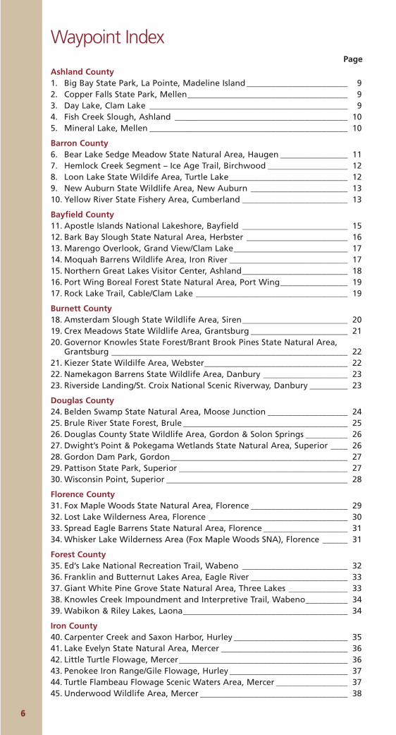
Waypoint IndexPage
Ashland County1. Big Bay State Park, La Pointe, Madeline Island________________________ 92. Copper Falls State Park, Mellen______________________________________ 93. Day Lake, Clam Lake _______________________________________________ 94. Fish Creek Slough, Ashland _________________________________________ 105. Mineral Lake, Mellen _______________________________________________ 10
Barron County6. Bear Lake Sedge Meadow State Natural Area, Haugen ________________ 117. Hemlock Creek Segment – Ice Age Trail, Birchwood ___________________ 128. Loon Lake State Wildife Area, Turtle Lake____________________________ 129. New Auburn State Wildlife Area, New Auburn _______________________ 1310. Yellow River State Fishery Area, Cumberland _________________________ 13
Bayfield County11. Apostle Islands National Lakeshore, Bayfield _________________________ 1512. Bark Bay Slough State Natural Area, Herbster ________________________ 1613. Marengo Overlook, Grand View/Clam Lake___________________________ 1714. Moquah Barrens Wildlife Area, Iron River ____________________________ 1715. Northern Great Lakes Visitor Center, Ashland_________________________ 1816. Port Wing Boreal Forest State Natural Area, Port Wing________________ 1917. Rock Lake Trail, Cable/Clam Lake ____________________________________ 19
Burnett County18. Amsterdam Slough State Wildlife Area, Siren_________________________ 2019. Crex Meadows State Wildlife Area, Grantsburg _______________________ 2120. Governor Knowles State Forest/Brant Brook Pines State Natural Area,
Grantsburg ________________________________________________________ 2221. Kiezer State Wildilfe Area, Webster__________________________________ 2222. Namekagon Barrens State Wildlife Area, Danbury ____________________ 2323. Riverside Landing/St. Croix National Scenic Riverway, Danbury _________ 23
Douglas County24. Belden Swamp State Natural Area, Moose Junction ___________________ 2425. Brule River State Forest, Brule _______________________________________ 2526. Douglas County State Wildlife Area, Gordon & Solon Springs __________ 2627. Dwight’s Point & Pokegama Wetlands State Natural Area, Superior ____ 2628. Gordon Dam Park, Gordon__________________________________________ 2729. Pattison State Park, Superior ________________________________________ 2730. Wisconsin Point, Superior ___________________________________________ 28
Florence County31. Fox Maple Woods State Natural Area, Florence _______________________ 2932. Lost Lake Wilderness Area, Florence _________________________________ 3033. Spread Eagle Barrens State Natural Area, Florence ____________________ 3134. Whisker Lake Wilderness Area (Fox Maple Woods SNA), Florence ______ 31
Forest County35. Ed’s Lake National Recreation Trail, Wabeno _________________________ 3236. Franklin and Butternut Lakes Area, Eagle River _______________________ 3337. Giant White Pine Grove State Natural Area, Three Lakes ______________ 3338. Knowles Creek Impoundment and Interpretive Trail, Wabeno__________ 3439. Wabikon & Riley Lakes, Laona_______________________________________ 34
Iron County40. Carpenter Creek and Saxon Harbor, Hurley ___________________________ 3541. Lake Evelyn State Natural Area, Mercer ______________________________ 3642. Little Turtle Flowage, Mercer________________________________________ 3643. Penokee Iron Range/Gile Flowage, Hurley ____________________________ 3744. Turtle Flambeau Flowage Scenic Waters Area, Mercer _________________ 3745. Underwood Wildlife Area, Mercer ___________________________________ 38
77
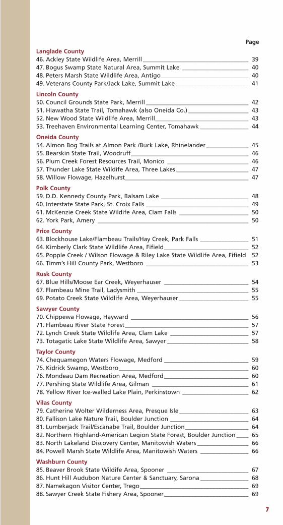
Page
Langlade County46. Ackley State Wildlife Area, Merrill ___________________________________ 3947. Bogus Swamp State Natural Area, Summit Lake ______________________ 4048. Peters Marsh State Wildlife Area, Antigo_____________________________ 4049. Veterans County Park/Jack Lake, Summit Lake ________________________ 41
Lincoln County50. Council Grounds State Park, Merrill __________________________________ 4251. Hiawatha State Trail, Tomahawk (also Oneida Co.) ____________________ 4352. New Wood State Wildlife Area, Merrill_______________________________ 4353. Treehaven Environmental Learning Center, Tomahawk ________________ 44
Oneida County54. Almon Bog Trails at Almon Park /Buck Lake, Rhinelander______________ 4555. Bearskin State Trail, Woodruff_______________________________________ 4656. Plum Creek Forest Resources Trail, Monico ___________________________ 4657. Thunder Lake State Wildife Area, Three Lakes ________________________ 4758. Willow Flowage, Hazelhurst_________________________________________ 47
Polk County59. D.D. Kennedy County Park, Balsam Lake _____________________________ 4860. Interstate State Park, St. Croix Falls __________________________________ 4961. McKenzie Creek State Wildife Area, Clam Falls _______________________ 5062. York Park, Amery __________________________________________________ 50
Price County63. Blockhouse Lake/Flambeau Trails/Hay Creek, Park Falls ________________ 5164. Kimberly Clark State Wildlife Area, Fifield____________________________ 5265. Popple Creek / Wilson Flowage & Riley Lake State Wildlife Area, Fifield 5266. Timm’s Hill County Park, Westboro __________________________________ 53
Rusk County67. Blue Hills/Moose Ear Creek, Weyerhauser ____________________________ 5467. Flambeau Mine Trail, Ladysmith _____________________________________ 5569. Potato Creek State Wildlife Area, Weyerhauser _______________________ 55
Sawyer County70. Chippewa Flowage, Hayward _______________________________________ 5671. Flambeau River State Forest_________________________________________ 5772. Lynch Creek State Wildlife Area, Clam Lake __________________________ 5773. Totagatic Lake State Wildlife Area, Sawyer ___________________________ 58
Taylor County74. Chequamegon Waters Flowage, Medford ____________________________ 5975. Kidrick Swamp, Westboro___________________________________________ 6076. Mondeau Dam Recreation Area, Medford____________________________ 6077. Pershing State Wildlife Area, Gilman ________________________________ 6178. Yellow River Ice-walled Lake Plain, Perkinstown ______________________ 62
Vilas County79. Catherine Wolter Wilderness Area, Presque Isle_______________________ 6380. Fallison Lake Nature Trail, Boulder Junction __________________________ 6481. Lumberjack Trail/Escanabe Trail, Boulder Junction_____________________ 6482. Northern Highland-American Legion State Forest, Boulder Junction ____ 6583. North Lakeland Discovery Center, Manitowish Waters _________________ 6684. Powell Marsh State Wildlife Area, Manitowish Waters ________________ 66
Washburn County85. Beaver Brook State Wildife Area, Spooner ___________________________ 6786. Hunt Hill Audubon Nature Center & Sanctuary, Sarona ________________ 6887. Namekagon Visitor Center, Trego____________________________________ 6988. Sawyer Creek State Fishery Area, Spooner____________________________ 69
Ashland CountyWith just over 16 people per square mile, AshlandCounty is one of the least-populated counties innorthern Wisconsin. More than half of its 1,043square miles is either in the Chequamegon-NicoletNational Forest, or the Bad River IndianReservation.
The county seat, Ashland (population 8,695) isthe home of Timeless Timber (888/653-5647,www.timelesstimber.com), a uniquely Wisconsin
company that salvages, saws and sells 100-year-old logs fromthe bottom of Lake Superior. Nearby, the South ShoreBrewery (715/682-9199, www.southshorebrewery.com) offersfun tours; call for times. Just west of town, the Northern GreatLakes Visitors Center (715/685-9983, www.northerngreat-lakescenter.org) was made for travelers offering trip planning,an observation tower, video presentations, and cultural and his-toric exhibits.
Twelve miles west of Mellen you can visit Morgan Falls.The falls drop 80-100 feet in an elegant cascade, diagonally tra-versing a dramatic 70 foot granite face.
88
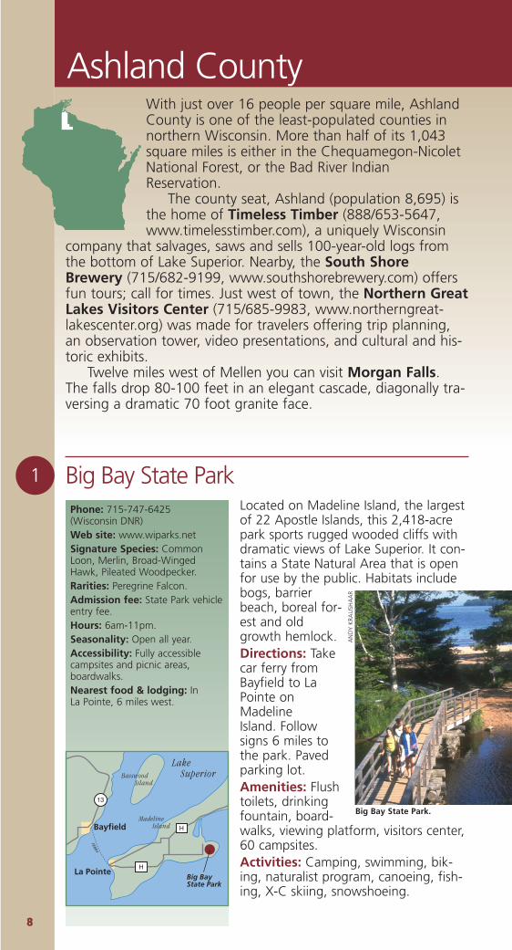
1 Big Bay State Park Located on Madeline Island, the largestof 22 Apostle Islands, this 2,418-acrepark sports rugged wooded cliffs withdramatic views of Lake Superior. It con-tains a State Natural Area that is openfor use by the public. Habitats includebogs, barrierbeach, boreal for-est and oldgrowth hemlock.Directions: Takecar ferry fromBayfield to LaPointe onMadelineIsland. Followsigns 6 miles tothe park. Pavedparking lot. Amenities: Flushtoilets, drinkingfountain, board-walks, viewing platform, visitors center,60 campsites.Activities: Camping, swimming, bik-ing, naturalist program, canoeing, fish-ing, X-C skiing, snowshoeing.
Phone: 715-747-6425 (Wisconsin DNR)Web site: www.wiparks.netSignature Species: CommonLoon, Merlin, Broad-WingedHawk, Pileated Woodpecker.Rarities: Peregrine Falcon.Admission fee: State Park vehicleentry fee.Hours: 6am-11pm. Seasonality: Open all year.Accessibility: Fully accessiblecampsites and picnic areas,boardwalks. Nearest food & lodging: In La Pointe, 6 miles west.
13
Bayfield
La Pointe
FERRY
H
H
Big BayState Park
Lake SuperiorBasswood
Island
Madeline Island
Big Bay State Park.
AN
DY
KRA
USH
AA
R
99
Phone: 715/264-2511 (US Forest Service)Web site: www.fs.fed.us/r9/cnnf/Rarities: Bald Eagle, Osprey. Admission Fee: Yes. Hours: 24/7. Accessibility: Yes. Signature Species: Waterfowl,warblers.Seasonality: Best in spring,summer & fall. Nearest food & lodging: InClam Lake, .5-miles southwest.
Day LakeThis 100-acre US Forest Service camp-ground area flanks 625-acre Day Lake.A variety of habitats, including floatingsphagnum-tamarack bogs, attract sea-sonal waterfowl, raptors, andNorthwoods mammals. Barrier-freeviewing platforms, two nesting struc-tures and shoreline hiking trails providegreat opportunities to watch ospreyand bald eagle.Directions: From Clam Lake take Cty.M west .33 miles, past Cty. GG. Followsigns to the boat landing and day usearea. Park in the paved lot near the pic-nic area. Amenities: Restrooms, drinking foun-tain, gravel trails, viewing platform, hik-ing trails, picnicking, camping (66 sites),boat landing, fishing, swimming beach.Notes: Bring your fishing gear; DayLake is loaded with small-to-mediumMusky.
Day Lake
7777
ClamLake
To H
ayw
ard To Mellen
GG
GG
M
M
Day Lake
3
Copper Falls State ParkThis 2,700-acre state park is famous forits 30-foot waterfall on the Bad River.The park is mostly forested with north-ern hardwoods, aspen and spruce/fir. Itsriver valleys, canyons, waterfalls, smalllakes and bogs attract seasonal water-fowl, songbirds, and raptors.Directions: Two miles north of Mellenvia Hwy. 169.Amenities: 55 campsites, 13 with elec-tric hookup; restrooms, drinking foun-tain, showers, gravel trails, boardwalks,concessions, swimming beach, hiking,mountain biking & X-C ski trails.Notes: Early May is a great time to seenumerous wildflowers in bloom. It ispossible to hear howling wolf packs inthe wee morning hours. An elk herdhas been established 20 miles SE of thepark. The park includes severalCCC/WPA log structures, bridges andshelters. Its main trail was laid out andbuilt by the veterans of WWI.
2
Phone: 715/274-5123 (Wisconsin DNR)Web site: www.wiparks.netAdmission fee: State Park vehicleadmission sticker required.Hours: Park open 6am-11pmdaily, all year. Office opens at 8amin the spring, summer and fall. Accessibility: Partial, with onerustic cabin for use by disabledpersons, some trail sections areaccessible, beach is partiallyaccessible, shower building isaccessible.Parking: Paved parking lots.Nearest food & lodging: InMellen, two miles south.
13
13
77
77
169
Mellen
To H
ayw
ard
To Hurley
To Ashland
P
GG
Copper FallsState Park

1100
Mineral LakeThis 1,000-acre US Forest Service camp-ground area flanks 225-acre MineralLake. Birds found here include manyinterior forest birds such as the Black-throated Blue Warbler, Winter Wren,Veery, Pileated Woodpecker, Ovenbird,Hermit Thrush, Great Crested Flycatcher,Northern Parula Warbler and woodlandraptors.Directions: From Mellen, 8 miles weston Cty. GG to Forest Road 187 (MineralLake Rd.). Turn right (north) on 187,then .2 miles to the boat landing.Launch canoe or boat to access wildand natural areas.Amenities: Camping (12 sites), rest-rooms, drinking fountain, boat landing,fishing.Notes: A great place to see almost allspecies of northern Wisconsin ferns,including rare ones. The PenokeeOverlook between Mellen and MineralLake on Cty GG offers a spectacularview of this portion of the Gogebicrange.
5
Ashland County
Phone: 715/264-2511 (US ForestService)Web site: www.fs.fed.us/r9/cnnf Rarities: Bald Eagle, Loon, WoodTurtle, Timber Wolf, Elk, CanadaYew.Admission fee: A parkingpermit is required at the boatlanding: $3/daily or $10/annually.Hours: 24/7.Parking: There is parking at theboat landing for about 12 cars.Nearest food & lodging:Mellen 8 miles east, or ClamLake 13 miles south.
Mineral Lake
English Lake
FR 1
87FR
188
MINERAL LAKE RD
FR 184
To Mellen
To C
lam
Lak
e
GG
GGMineral Lake
Phone: 715/682-7071 (City of Ashland)Web site: www.visitashland.comSignature Species: Ducks,twenty species of warblers,shorebirds, wading birds, TundraSwan, Horned Grebe, HudsonianGodwit, Red-necked Phalarope,Black Tern, and Yellow-headedBlackbird.Rarities: Snowy Egret, TricoloredHeron, Little Gull, Bonaparte’s Gull.Hours: 24/7. Accessibility: Fully accessible. Parking: Paved Parking lot.
Fish Creek SloughA 700-acre slough close to LakeSuperior. Habitat includes marsh,lagoon, edge areas, second growthhardwood forest, and boreal forest thatattract seasonal waterfowl, songbirds,and raptors.Directions:Access theslough fromPrentice Parklocated on thecity’s west sidevia Hwy. 2. Amenities:Camping (nineRV sites withelectrichookup, seven tent sites), restrooms,drinking fountain, gravel trails, viewingplatform, Bayview Beach, and fishingpier. Notes: The fenced deer yard is worth-while any time of year for bird watch-ing.
4
13
13
13
112
137
A
2
22
Lake Superior
Ashland
To W
ashb
urn
To S
uper
ior
To M
ellen
To HurleyNorthern
Great Lakes Visitor Center
Fish CreekSlough
MIK
EM
CD
OW
ELL
Bonaparte’s Gull.
1111
Barron CountyThe Dakota and Chippewa Indians valued the landthat is now Barron County for its clear shallowlakes ringed with wild rice beds. European settlersvalued it for its timber resources.
Rice Lake (population 7,998) straddles thebeautiful Red Cedar River. It is the southern trail-head of the Wild Rivers State Trail (715/635-4490, www.wiparks.net), a limestone-surfaced
railbed trail running north 40 miles to Solon Springs. Rice Lake isalso the home of the J.C. Bearpaw Co. (715/236-7300,www.thebearpawcompany.com), a retail sporting goods storewith a truly fascinating collection of bird, fish and mammalmounts from around the world. The Red Barn Theater(888/688-3770) presents a summer season of professional the-ater.
Just south of town, the Pioneer Village Museum(715/458-2841) is a recreation of a logging era town displayingmore than 400 items of historic interest.
In Chetek, visit Time & Again Antique Mall (715-924-4000, www.wisconsinantiques.com/timeandagain) or surroundyourself with luxury at Canoe Bay Resort (715-924-4594,www.canoebay.com).
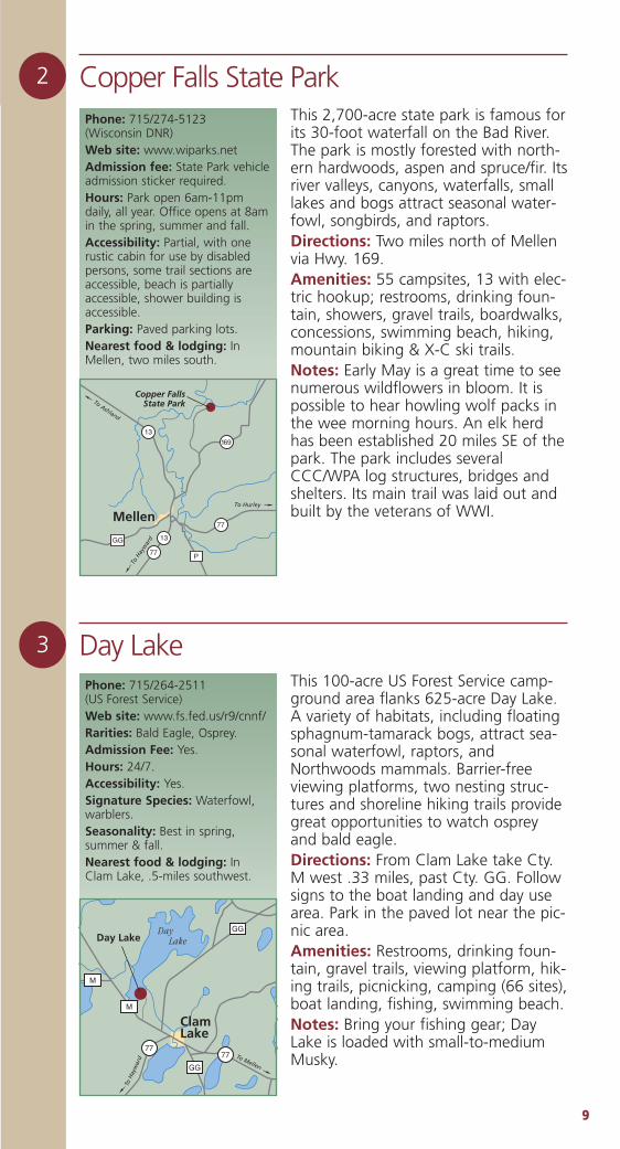
Phone: 608/266-7012(Wisconsin DNR)Web site: www.dnr.state.wi.us/org/land/er/ snaSignature Species: Swamp andSong Sparrow, Yellow Warbler,Sora Rail, and Sedge Wren.Rarities: American Bittern,LeConte’s Sparrow, Yellow Rail.Hours: 24/7. Nearest food & lodging: InHaugen, 1 mile east.
Bear Lake Sedge Meadow State Natural Area
This 250-acre sedge meadow wraps alarge bay on the southern shore of BearLake. The meadow is open with scat-tered islands of bog birch, alder, blackspruce andtamarack closeto the lake.Much of themeadow isdominated bymarsh cinque-foil, cotton-grass, and bluejoint grass.Dragon’s mouthorchid, leather-leaf, bog-laurel, bog-rosemary and Labrador-tea are scat-tered throughout.Directions: From the intersection ofCty. SS and V in Haugen, go west on V0.3 miles, then north and west on Cty.VV 1.6 miles to a parking area south ofthe road.
To Sp
oo
ner
VV
Bear Lake Sedge MeadowSNA
53
V
V
V
ToRice
Lake
Bear Lake
Haugen
6
Sora Rail.
MIK
EM
CD
OW
ELL
1122
Hemlock Creek Segment, Ice Age TrailThis segment of the Ice Age Trail cross-es Pigeon Creek and passes through asmall stand of even-age aspen andbirch before reaching a prairie, whichgives way to a stand of old-growthmixed hardwoods. The climax viewingarea is at a large beaver pond with anOsprey nest and Great Blue Heron rook-ery consisting of more than 75 nests.The site offers some boardwalks.Directions: From Birchwood travel weston Hwy. 48 one mile, turn left on LochLomand Blvd. 2.5 miles to FinohornRoad (note large Ice Age Trail sign) andcontinue for 100 yards. Park on theshoulder of the road.Notes: This site includes several signifi-cant glacial geological formations aswell as a large beaver colony withlodge and dam.
7
Phone: 715/537-6295 (Ice AgePark and Trail Foundation)Web site: www.iceagetrail.orgSignature Species: Great BlueHeron, and Osprey.Hours: 24/7; but closed duringdeer hunting season.Nearest food & lodging: AtBirchwood, 4 miles north.
To R
ice Lake
Hemlock Creek Segment, Ice Age Trail
T48
48Cedar Lake
Balsam Lake Birchwood
Phone: 715/537-5046(Wisconsin DNR)Web site: www.dnr.state.wi.us/org/land/wildlife
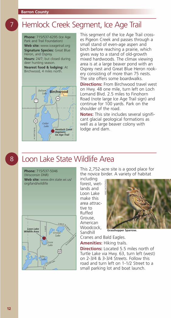
Loon Lake State Wildlife AreaThis 2,752-acre site is a good place forthe novice birder. A variety of habitatincludingforest, wet-lands andLoon Lakemake thisarea attrac-tive toRuffedGrouse,AmericanWoodcock,SandhillCranes and Bald Eagles.Amenities: Hiking trails.Directions: Located 5.5 miles north ofTurtle Lake via Hwy. 63, turn left (west)on 2-3/4 & 3-3/4 Streets. Follow thisroad and turn left on 1-1/2 Street to asmall parking lot and boat launch.
2-3/4 ST &
3-3/4 ST
1-1/
2 ST
To C
umber
land
Loon LakeWildlife Area
63
ekaLeltruT
oT
LoonLake
Crystal Lake
Echo Lake
8
Barron County
Grasshopper Sparrow.
MIK
EM
CD
OW
ELL
1133
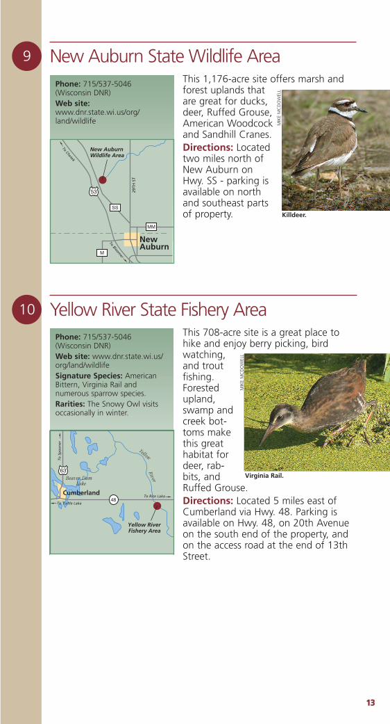
New Auburn State Wildlife AreaThis 1,176-acre site offers marsh andforest uplands thatare great for ducks,deer, Ruffed Grouse,American Woodcockand Sandhill Cranes. Directions: Locatedtwo miles north ofNew Auburn onHwy. SS - parking isavailable on northand southeast partsof property.
9
Phone: 715/537-5046(Wisconsin DNR)Web site:www.dnr.state.wi.us/org/land/wildlife
New AuburnWildlife Area
53
MM
SS
M
29TH
ST
New Auburn
To Chetek
To Bloomer
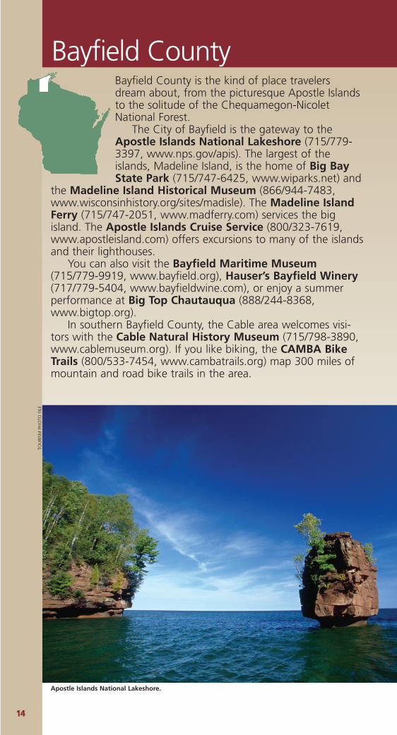
Yellow River State Fishery AreaThis 708-acre site is a great place tohike and enjoy berry picking, birdwatching,and troutfishing.Forestedupland,swamp andcreek bot-toms makethis greathabitat fordeer, rab-bits, andRuffed Grouse.Directions: Located 5 miles east ofCumberland via Hwy. 48. Parking isavailable on Hwy. 48, on 20th Avenueon the south end of the property, andon the access road at the end of 13thStreet.
10
Phone: 715/537-5046(Wisconsin DNR)Web site: www.dnr.state.wi.us/org/land/wildlifeSignature Species: AmericanBittern, Virginia Rail andnumerous sparrow species.Rarities: The Snowy Owl visitsoccasionally in winter.
To S
po
on
er
To Turtle Lake
To Rice Lake
Yellow RiverFishery Area
48
63Beaver Dam Lake
Yellow
River
Cumberland
Killdeer.
MIK
EM
CD
OW
ELL
Virginia Rail.
MIK
EM
CD
OW
ELL
1144
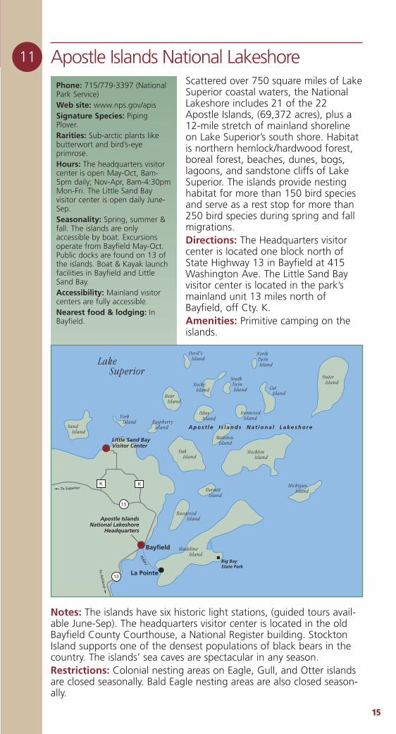
Bayfield CountyBayfield County is the kind of place travelersdream about, from the picturesque Apostle Islandsto the solitude of the Chequamegon-NicoletNational Forest.
The City of Bayfield is the gateway to theApostle Islands National Lakeshore (715/779-3397, www.nps.gov/apis). The largest of theislands, Madeline Island, is the home of Big BayState Park (715/747-6425, www.wiparks.net) and
the Madeline Island Historical Museum (866/944-7483,www.wisconsinhistory.org/sites/madisle). The Madeline IslandFerry (715/747-2051, www.madferry.com) services the bigisland. The Apostle Islands Cruise Service (800/323-7619,www.apostleisland.com) offers excursions to many of the islandsand their lighthouses.
You can also visit the Bayfield Maritime Museum(715/779-9919, www.bayfield.org), Hauser’s Bayfield Winery(717/779-5404, www.bayfieldwine.com), or enjoy a summerperformance at Big Top Chautauqua (888/244-8368,www.bigtop.org).
In southern Bayfield County, the Cable area welcomes visi-tors with the Cable Natural History Museum (715/798-3890,www.cablemuseum.org). If you like biking, the CAMBA BikeTrails (800/533-7454, www.cambatrails.org) map 300 miles ofmountain and road bike trails in the area.
Apostle Islands National Lakeshore.
TOU
RISM
PH
OTO
FIL
E
1155
11 Apostle Islands National Lakeshore Scattered over 750 square miles of LakeSuperior coastal waters, the NationalLakeshore includes 21 of the 22Apostle Islands, (69,372 acres), plus a12-mile stretch of mainland shorelineon Lake Superior’s south shore. Habitatis northern hemlock/hardwood forest,boreal forest, beaches, dunes, bogs,lagoons, and sandstone cliffs of LakeSuperior. The islands provide nestinghabitat for more than 150 bird speciesand serve as a rest stop for more than250 bird species during spring and fallmigrations.Directions: The Headquarters visitorcenter is located one block north ofState Highway 13 in Bayfield at 415Washington Ave. The Little Sand Bayvisitor center is located in the park’smainland unit 13 miles north ofBayfield, off Cty. K.Amenities: Primitive camping on theislands.
Phone: 715/779-3397 (NationalPark Service)Web site: www.nps.gov/apis Signature Species: PipingPlover. Rarities: Sub-arctic plants likebutterwort and bird’s-eyeprimrose.Hours: The headquarters visitorcenter is open May-Oct, 8am-5pm daily; Nov-Apr, 8am-4:30pmMon-Fri. The Little Sand Bayvisitor center is open daily June-Sep.Seasonality: Spring, summer &fall. The islands are onlyaccessible by boat. Excursionsoperate from Bayfield May-Oct.Public docks are found on 13 ofthe islands. Boat & Kayak launchfacilities in Bayfield and LittleSand Bay.Accessibility: Mainland visitorcenters are fully accessible. Nearest food & lodging: InBayfield.
To Superior
To A
shlan
d
FERRY
13
13
Bayfield
Big BayState Park
La Pointe
K K
Lake Superior
Basswood Island
Oak Island
Sand Island
York Island Raspberry
Island
Manitou Island
Hermit Island
Ironwood Island
Stockton Island
Michigan Island
Cat Island
Outer Island
Otter Island
Devil's Island
Rocky Island
South Twin Island
North Twin Island
Bear Island
Madeline Island
Apostle IslandsNational Lakeshore
Headquarters
A p o s t l e I s l a n d s N a t i o n a l L a k e s h o r e
Little Sand BayVisitor Center
Notes: The islands have six historic light stations, (guided tours avail-able June-Sep). The headquarters visitor center is located in the oldBayfield County Courthouse, a National Register building. StocktonIsland supports one of the densest populations of black bears in thecountry. The islands’ sea caves are spectacular in any season.Restrictions: Colonial nesting areas on Eagle, Gull, and Otter islandsare closed seasonally. Bald Eagle nesting areas are also closed season-ally.
1166
Bayfield County
13 Marengo OverlookThis 4-mile section of the NorthCountry Trail winds through theMarengo Semi-Primitive, Non-motor-ized Area (2,400 acres). The trail hasdifficult sections with some steepslopes. This northern mesic hardwoodforest is home to thrushes, vireos, war-blers, woodpeckers, flycatchers, andwoodland raptors.Directions: From Grand View travelsouth on Cty. D 3 miles to Forest Road377, turn east (left) on 377 and travel 4miles to Forest Road 202, turn south(right) on 202, the trailhead is 1.5 mileson the left with a graveled parking lotfor 3-4 cars. Notes: A rock outcrop along the trail,provides a spectacular view of theMarengo River Gorge (1,000 feetdeep). There is excellent trout fishing inthe Marengo River.
Phone: 715/634-4821 (US Forest Service)Web site: www.fs.fed.us/r9/cnnfHours: 24/7.Nearest food & lodging: AtClam Lake, 10 miles southeast.The US Forest Service operatessmall campgrounds nearby atBeaver Lake (10 sites, 3 milesaway) and Lake Three (8 sites, 6miles away).
12 Bark Bay Slough State Natural AreaA 552-acre shore fen and open bogwith sand spit, lagoon, springs andwetlands along a bay between tworocky headlands of the Lake Superiorcoast. Directions: From Herbster go east 3.5miles on Hwy. 13, then north on BarkBay Road 0.5 miles to a boat landingand parking lot on the east side of theroad. The best access to the sand spitand bog is by canoe. Most of the sandspit is private.Notes: The small village of Cornucopiashould be a stop as you travel the area.Check the shoreline for interestingbirds. Stop where the Siskiwit Riverempties into Lake Superior to look forRed-Throated Loons. A small park onHwy 13 offers free spring water from awell tap to the public - bring your ownjug.
Phone: 715-372-4866 (Wisconsin DNR)Web site: www.dnr.state.wi.us/org/land/er/sna/Signature Species: Bald Eagle,Northern Harrier, Yellow Rail, andAmerican Bittern.Hours: 24/7.Nearest food & lodging: InHerbster, 3 miles west.
13
To Bayfield
To Superior Herbster
Lake Superior
Bark BaySlough SNA
BARK BAY
BARK
PO
INT
RD
SLOU
GH
RD
FR 377
FR 2
02
MarengoOverlook
D
ToG
rand
view
1177
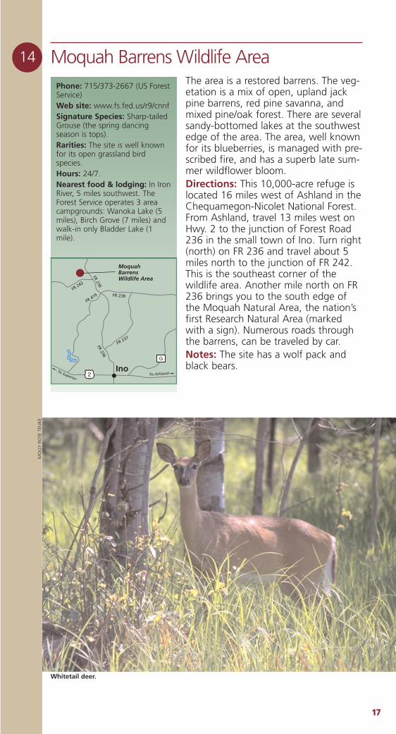
14 Moquah Barrens Wildlife AreaThe area is a restored barrens. The veg-etation is a mix of open, upland jackpine barrens, red pine savanna, andmixed pine/oak forest. There are severalsandy-bottomed lakes at the southwestedge of the area. The area, well knownfor its blueberries, is managed with pre-scribed fire, and has a superb late sum-mer wildflower bloom.Directions: This 10,000-acre refuge islocated 16 miles west of Ashland in theChequamegon-Nicolet National Forest.From Ashland, travel 13 miles west onHwy. 2 to the junction of Forest Road236 in the small town of Ino. Turn right(north) on FR 236 and travel about 5miles north to the junction of FR 242.This is the southeast corner of thewildlife area. Another mile north on FR236 brings you to the south edge ofthe Moquah Natural Area, the nation’sfirst Research Natural Area (markedwith a sign). Numerous roads throughthe barrens, can be traveled by car. Notes: The site has a wolf pack andblack bears.
Phone: 715/373-2667 (US ForestService)Web site: www.fs.fed.us/r9/cnnfSignature Species: Sharp-tailedGrouse (the spring dancingseason is tops).Rarities: The site is well knownfor its open grassland birdspecies.Hours: 24/7.Nearest food & lodging: In IronRiver, 5 miles southwest. TheForest Service operates 3 areacampgrounds: Wanoka Lake (5miles), Birch Grove (7 miles) andwalk-in only Bladder Lake (1mile).
FR 236
FR 236
FR 237
FR 238FR 419
FR 242
2
G
To AshlandTo Superior
MoquahBarrensWildlife Area
Ino
Whitetail deer.
MO
LLY
RO
SE T
EUK
E
1188
Bayfield County
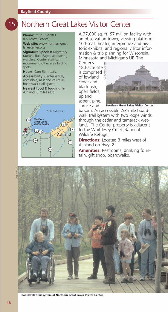
15 Northern Great Lakes Visitor CenterA 37,000 sq. ft, $7 million facility withan observation tower, viewing platform,100-seat theater, interpretive and his-toric exhibits, and regional visitor infor-mation & trip planning for Wisconsin,Minnesota and Michigan’s UP. TheCenter’s180-acre siteis comprisedof lowlandcedar andblack ash,open fields,uplandaspen, pine,spruce andbalsam. An accessible 2/3-mile board-walk trail system with two loops windsthrough the cedar and tamarack wet-lands. The Center property is adjacentto the Whittlesey Creek NationalWildlife Refuge.Directions: Located 3 miles west ofAshland on Hwy. 2. Amenities: Restrooms, drinking foun-tain, gift shop, boardwalks.
Phone: 715/685-9983 (US Forest Service)Web site: www.northerngreatlakescenter.orgSignature Species: Migratoryraptors, Bald Eagle, and springwarblers. Center staff canrecommend other area birdingspots.Hours: 9am-5pm daily.Accessibility: Center is fullyaccessible, as is the 2/3-mileboardwalk trail system.Nearest food & lodging: InAshland, 3 miles east.
13
13
13
112
137
A
2
22
Lake Superior
Ashland
To W
ashb
urn
To S
uper
ior
To M
ellen
To HurleyNorthern
Great Lakes Visitor Center
Northern Great Lakes Visitor Center.TO
URI
SM P
HO
TO F
ILE
DA
LE T
HO
MA
S
Boardwalk trail system at Northern Great Lakes Visitor Center.
1199
16 Port Wing Boreal Forest State Natural AreaThis natural area features two units ofnorthern dry-mesic forest on sand spitsinland from the Lake Superior shoreline.The forest has large white and redpines that form a super-canopy overwhite spruce, balsam fir, red maple,white birch, mountain maple, yellowbirch and white cedar. The ground layercontains blueberries, large-leaved aster,and several club-mosses. Between theforested sand spit and beach to thenorth is a sedge meadow, shrubswamp, and bog. The wetland area isan extension of the estuary of the FlagRiver, which separates the two units.Directions: For the eastern unit, fromPort Wing travel east 1.6 miles on Hwy.13, turn west 0.2 miles on LakeviewRoad, then north on Big Pete Roadabout 0.5 mile to Lake Superior. For thewestern unit, from Port Wing travelnorth 0.6 miles on Washington Ave,turn west 1 mile on Quarry Road, thennorth on Point Road 0.25 miles to theparking area.
Phone: 715/372-4866 (Wisconsin DNR)Web site: www.dnr.state.wi.us/org/land/er/sna/Signature Species: Blackburnian,Black-and-White, and NorthernParula Warblers.Rarities: Black meadowhawkdragonfly and bog copperbutterfly.Hours: 24/7.Nearest food & lodging: In PortWing one mile east or west.
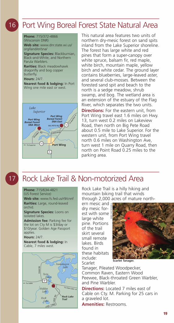
17 Rock Lake Trail & Non-motorized AreaRock Lake Trail is a hilly hiking andmountain biking trail that windsthrough 2,000 acres of mature north-ern mesic anddry mesic for-est with somelarge whitepine. Portionsof the trailskirt severalsmall remotelakes. Birdsfound inthese habitatsinclude:ScarletTanager, Pileated Woodpecker,Common Raven, Eastern WoodPeewee, Black-throated Green Warbler,and Pine Warbler.Directions: Located 7 miles east ofCable on Cty. M. Parking for 25 cars ina graveled lot.Amenities: Restrooms.
Phone: 715/634-4821 (US Forest Service)Web site: www.fs.fed.us/r9/cnnfRarities: Large, round-leavedorchid.Signature Species: Loons onisolated lakes.Admission fee: Parking fee forthe lot on Cty M is $3/day or$10/year. Golden Age Passportapplies.Hours: 24/7.Nearest food & lodging: InCable, 7 miles west.
RD
LAND
LAK
E
DA
M R
D
LOST
Rock LakeTrail
MTo Cable
To Clam Lake
Namekagon Lake
Rock Lake
Hidden Lake
Twin Lakes
BIG PETE RD
13
13
To B
ayfie
ld
To Superior Port Wing
A
Lake Superior
Port WingBoreal Forest
SNA West
Port WingBoreal Forest
SNA East
QUARRY LAKEVIEWRD
Scarlet Tanager.
MIK
EM
CD
OW
ELL
Burnett County
2200
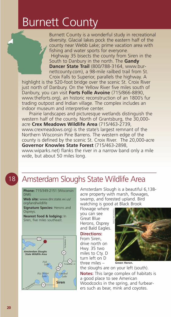
18 Amsterdam Sloughs State Wildlife Area Phone: 715/349-2151 (WisconsinDNR)Web site: www.dnr.state.wi.us/org/land/wildlifeSignature Species: Herons andOspreys.Nearest food & lodging: InSiren, five miles southeast.
Amsterdam Slough is a beautiful 6,138-acre property with marsh, flowages,swamp, and forested upland. Birdwatching is good at Black BrookFlowage whereyou can seeGreat BlueHerons, Ospreyand Bald Eagles.Directions:From Siren,drive north onHwy. 35 twomiles to Cty. Dturn left on Dthree miles –the sloughs are on your left (south). Notes: This large complex of habitats isa good place to see AmericanWoodcocks in the spring, and furbear-ers such as bear, mink and coyotes.
Amsterdam SloughsState Wildlife Area
D
To Spooner
To Grantsburg
To D
anb
ury
70
70
70
35
35
Crooked Lake
Big Doctor Lake
Fish Lake
Siren
Burnett County is a wonderful study in recreationaldiversity. Glacial lakes pock the eastern half of thecounty near Webb Lake; prime vacation area withfishing and water sports for everyone.Highway 35 bisects the county from Siren in the
South to Danbury in the north. The GandyDancer State Trail (800/788-3164, www.bur-nettcounty.com), a 98-mile railbed trail from St.Croix Falls to Superior, parallels the highway. A
highlight is the 520-foot bridge over the scenic St. Croix Riverjust north of Danbury. On the Yellow River five miles south ofDanbury, you can visit Forts Folle Avoine (715/866-8890,www.theforts.org), an historic reconstruction of an 1800’s furtrading outpost and Indian village. The complex includes anindoor museum and interpretive center.
Prairie landscapes and picturesque wetlands distinguish thewestern half of the county. North of Grantsburg, the 30,000-acre Crex Meadows Wildlife Area (715/463-2739,www.crexmeadows.org) is the state’s largest remnant of theNorthern Wisconsin Pine Barrens. The western edge of thecounty is defined by the scenic St. Croix River. The 20,000-acreGovernor Knowles State Forest (715/463-2898,www.wiparks.net) flanks the river in a narrow band only a milewide, but about 50 miles long.
Green Heron.
MIK
EM
CD
OW
ELL
2211
19 Crex Meadows State Wildlife Area Phone: 715/463-2896 (Wisconsin DNR)Web site: www.dnr.state.wi.us/org/land/wildlifeSignature Species: Sharp-tailedGrouse, Trumpeter Swans, Ospreyand Bald Eagles.Rarities: Tricolored Heron andWhite Ibis.Hours: The visitors’ center is opendaily 10am-4pm (except majorholidays). The property is openyear-round.Accessibility: Handicapped-accessible wildflower trail andduck blinds. The visitors’ centerand grounds are also accessible.Nearest food & lodging: InGrantsburg, a mile south of thevisitors’ center.
A 30,000-acre wildlife area featuringrestored wetlands and upland brushprairie habitats with oak/jack pineforests interspersed. The propertyincludes 6,000 acres of open water.270 species of birds use the propertyalong with every mammal found inWisconsin and a good variety of rep-tiles, amphibians and invertebrates. Theproperty supports breeding populationsof Osprey, Bald Eagles, TrumpeterSwans, Karner blue butterflies andBlanding’s turtles. In the fall migration,as many as 50 Bald Eagles, 7,000Sandhill Cranes and 12,000 Canadaand Snow Geese fly into the area.Directions: The Crex Meadows VisitorsCenter is located at the corner of coun-ty roads D and F just north ofGrantsburg. The property spreads northand east, covering 30,000 acres. Apaved parking lot is located at the visi-tors center, with grass parking areasscattered throughout the property.Amenities: Restrooms, drinking foun-tain, gravel trails, boardwalks, viewingplatform, visitors center and gift shop.Restrictions: Dogs must be leashedduring nesting season. A 2,400-acrerefuge is off-limits to entry at all times.
70 70
48
To Minnesota To Siren
To S
t. C
roix
Fal
ls
F
D
Crex Meadows
Grantsburg
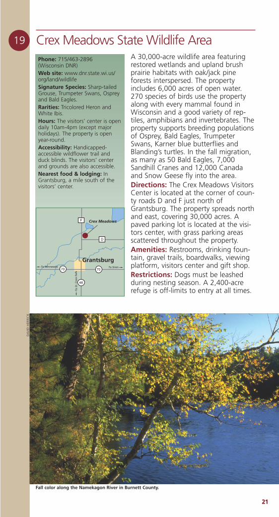
Fall color along the Namekagon River in Burnett County.
DA
VID
HER
RIC
K
2222
21 Kiezer State Wildlife AreaPhone: 715/635-2101Web site: www.dnr.state.wi.us/org/land/wildlifeSignature Species: Bald Eaglesand Great Blue Herons.Seasonality: Best in spring andfall.Nearest food & lodging: InWebster, 4 miles west.
Burnett County
Kiezer is 1,352 acres of water, marshand forested uplands with waterfowl,Ruffed Grouse, deer, AmericanWoodcock, snowshoe hares, BaldEagles andOsprey. You canalso fish BanachLake and BigLake.Directions:Located 6 mileseast of Websteron Cty. Rd. A, 4miles east ofHwy. 35. You’llfind a parkingarea as well aslogging roads throughout the property.Nearby attractions: Forts Folle AvoineHistorical Park is 7 miles west on Cty. U.
20 Governor Knowles State Forest/Brant Brook Pines State Natural AreaPhone: 715/463-2898 (Wisconsin DNR)Web site: www.dnr.state.wi.us/org/land/er/sna/Rarities: Black and White Warbler,and Yellow-throated Vireo.Hours: 24/7.Nearest food & lodging: InGrantsburg, 6 miles southeast.
A 190-acre stand of old growth redpines along the St. Croix River estimat-ed to have originated in the mid-1890s.The area includes many fine troutstreams as well as the St. Croix NationalScenic Riverway.Directions: Brant Brook Pines StateNatural Area is located within Gov.Knowles State Forest. From Grantsburg,go north on Cty. F 3.7 miles, then weston Bloom Road 2 miles, then north onGile Road 0.75 mile to the Brant BrookPines Ski Trail parking area at the right-angle corner. Follow the trail northwestinto the site.Activities: Camping, swimming, bik-ing, hiking and fishing in GovernorKnowles State Forest.Notes: The St. Croix River, which formspart of the Wisconsin/Minnesota bor-der, is a National Scenic Riverway; anarea of lush vegetation and movingwater that represents a diversity ofhabitat stretching 252 river milesthrough a narrow corridor of wild land.
35
To S
iren
To D
anb
ury
A
X
KiezerWildlife
Area
Webster
Devil's Lake
Johnson Lake
Brant Brook PinesSNA
To G
ran
tsb
urg
FCroi
x
St.
Riv
er
MI
NN
ES
OT
A
BLOOM RD
GIL
E R
D
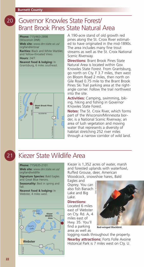
Red-winged Blackbird.
MIK
EM
CD
OW
ELL
2233
22 Namekagon Barrens State Wildlife AreaPhone: 715/635-2101 (Wisconsin DNR)Web site: www.dnr.state.wi.us/org/land/wildlifeSignature Species: Sharp-tailedGrouse.Rarities: Upland Sandpipers andBrewer’s Blackbird.Seasonality: Spring, summer andfall, with fewer viewingopportunities in winter.Nearest food & lodging: InDanbury, 10 miles southwest.
One of the largest pine barrens in thestate (5,200 acres) with some prairieand savanna, a few pockets of wet-lands and a smalllake. Among thescattered pinesare long stretchesof prairie. Theproperty is knownfor Sharp-tailedGrouse, UplandSandpipers,American Kestrels,Eastern Bluebirdsand Bald Eagles.Directions: The Namekagon Barrens liein two lobes. To get to the southernunit, drive north 5 miles from Danburyon Hwy 35, then east 4.5 miles onSpring Brook Tr. To get to the northernlobe unit from the southern unit, headnorth 2 miles on Namekagon Tr., then 1mile east on St. Croix Tr. You can parkat a small lookout site or alongside ofthe roads. This property is leased fromBurnett County.Amenities: Lookout post.
St. CroixNamekagonRiver
River
35
To S
up
erio
r
To Danbury
Namekagon BarrensWildlife Area
Northern Unit
Namekagon BarrensWildlife AreaSouthern Unit
SPRINGBROOK TR
ST. CROIX TR
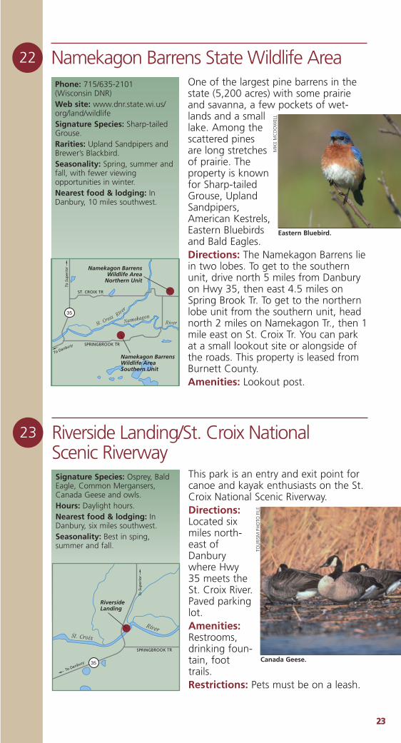
Eastern Bluebird.
MIK
EM
CD
OW
ELL
23 Riverside Landing/St. Croix National Scenic RiverwaySignature Species: Osprey, BaldEagle, Common Mergansers,Canada Geese and owls.Hours: Daylight hours.Nearest food & lodging: InDanbury, six miles southwest.Seasonality: Best in sping,summer and fall.
This park is an entry and exit point forcanoe and kayak enthusiasts on the St.Croix National Scenic Riverway.Directions:Located sixmiles north-east ofDanburywhere Hwy35 meets theSt. Croix River.Paved parkinglot.Amenities:Restrooms,drinking foun-tain, foottrails. Restrictions: Pets must be on a leash.
St. Croix
River
35
To S
up
erio
r
To Danbury
Riverside Landing
SPRINGBROOK TR
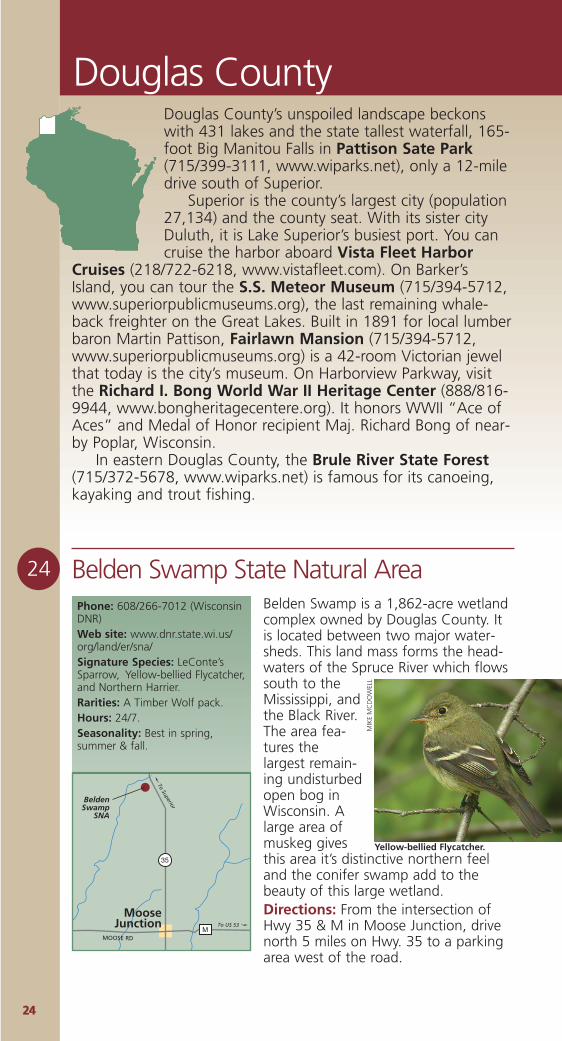
Canada Geese.
TOU
RISM
PH
OTO
FIL
E
2244
Douglas County
Belden Swamp is a 1,862-acre wetlandcomplex owned by Douglas County. Itis located between two major water-sheds. This land mass forms the head-waters of the Spruce River which flowssouth to theMississippi, andthe Black River.The area fea-tures thelargest remain-ing undisturbedopen bog inWisconsin. Alarge area ofmuskeg givesthis area it’s distinctive northern feeland the conifer swamp add to thebeauty of this large wetland.Directions: From the intersection ofHwy 35 & M in Moose Junction, drivenorth 5 miles on Hwy. 35 to a parkingarea west of the road.
24 Belden Swamp State Natural AreaPhone: 608/266-7012 (WisconsinDNR)Web site: www.dnr.state.wi.us/org/land/er/sna/Signature Species: LeConte’sSparrow, Yellow-bellied Flycatcher,and Northern Harrier.Rarities: A Timber Wolf pack.Hours: 24/7.Seasonality: Best in spring,summer & fall.
35
M
MooseJunction
To Superior
To US 53
BeldenSwamp
SNA
MOOSE RD
Yellow-bellied Flycatcher.
MIK
EM
CD
OW
ELL
Douglas County’s unspoiled landscape beckonswith 431 lakes and the state tallest waterfall, 165-foot Big Manitou Falls in Pattison Sate Park(715/399-3111, www.wiparks.net), only a 12-miledrive south of Superior.
Superior is the county’s largest city (population27,134) and the county seat. With its sister cityDuluth, it is Lake Superior’s busiest port. You cancruise the harbor aboard Vista Fleet Harbor
Cruises (218/722-6218, www.vistafleet.com). On Barker’sIsland, you can tour the S.S. Meteor Museum (715/394-5712,www.superiorpublicmuseums.org), the last remaining whale-back freighter on the Great Lakes. Built in 1891 for local lumberbaron Martin Pattison, Fairlawn Mansion (715/394-5712,www.superiorpublicmuseums.org) is a 42-room Victorian jewelthat today is the city’s museum. On Harborview Parkway, visitthe Richard I. Bong World War II Heritage Center (888/816-9944, www.bongheritagecentere.org). It honors WWII “Ace ofAces” and Medal of Honor recipient Maj. Richard Bong of near-by Poplar, Wisconsin.
In eastern Douglas County, the Brule River State Forest(715/372-5678, www.wiparks.net) is famous for its canoeing,kayaking and trout fishing.
2255
25 Brule River State Forest Phone: 715/372-8539 (Wisconsin DNR)Web site: www.dnr.state.wi.us/org/landSignature Species: The area hasconsistently produced northernraptors and Saw-whet Owls,northern songbirds such as theCape May Warbler, CanadaWarbler, and Connecticut Warbler,as well as Black-backedWoodpeckers.Seasonality: Good for migrantsin spring and fall, breeding birdsin summer, and finches andsongbirds in winter, but viewingopportunities may be limited. Nearest food & lodging: InBrule, two miles north.
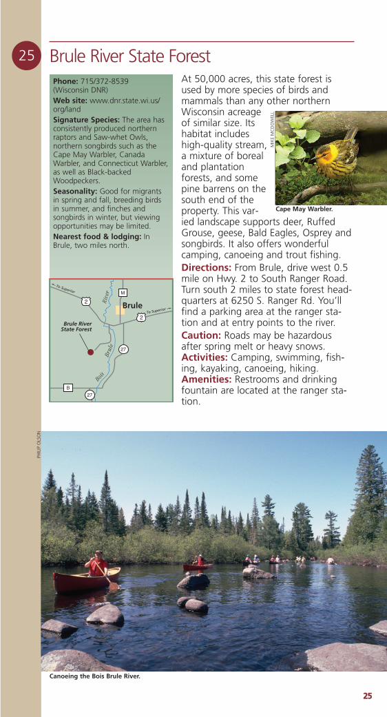
At 50,000 acres, this state forest isused by more species of birds andmammals than any other northernWisconsin acreageof similar size. Itshabitat includeshigh-quality stream,a mixture of borealand plantationforests, and somepine barrens on thesouth end of theproperty. This var-ied landscape supports deer, RuffedGrouse, geese, Bald Eagles, Osprey andsongbirds. It also offers wonderfulcamping, canoeing and trout fishing.Directions: From Brule, drive west 0.5mile on Hwy. 2 to South Ranger Road.Turn south 2 miles to state forest head-quarters at 6250 S. Ranger Rd. You’llfind a parking area at the ranger sta-tion and at entry points to the river.Caution: Roads may be hazardousafter spring melt or heavy snows.Activities: Camping, swimming, fish-ing, kayaking, canoeing, hiking.Amenities: Restrooms and drinkingfountain are located at the ranger sta-tion.
27
27
M
B
2
2 Brule
To Superior
Brule RiverState Forest
BoisBr
ule
Rive
r
To Superior
Cape May Warbler.
MIK
EM
CD
OW
ELL
Canoeing the Bois Brule River.
PHIL
IP O
LSO
N
2266
This 3,153-acre wetland lies at the con-fluence of the Pokegama & St. LouisRivers on the west side of Superior. Itincludes boreal forest, emergent marsh,and wet clay flats supporting shrubswamp and wet meadow. The St. Louisestuary, with its steep-sided ridges andboreal forest mix, is prime habitat forBald Eagles.Directions: This site is located withinthe Superior Municipal Forest. From theintersection of Hwys. 2 & 35 inSuperior, go south on 35 (TowerAvenue) 1 mile, then west on 28thStreet about 1.75 miles until it becomesBillings Drive. Access is from any num-ber of points along Billings Drive; you’llfind numerous parking areas. Severalhiking, biking, and ski trails windthrough the site. The natural area isalso accessible by water.
27 Dwight’s Point & Pokegama Wetlands State Natural AreaPhone: 608/266-7012 (Wisconsin DNR)Web site: www.dnr.state.wi.us/org/land/er/snaSignature Species: Bald Eagle.Hours: 24/7.Nearest food & lodging: InSuperior.
Douglas County
2
53
BUS
53
2
6135
535
35
St. Lo
uis Bay
Superior
Duluth
Dwight's Point &Pokegama WetlandsSNA
28TH ST
TOW
ER A
VE
BELNAP STTo Ashland
To Eau Claire
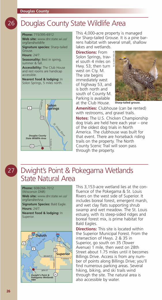
26 Douglas County State Wildlife AreaPhone: 715/395-6912Web site: www.dnr.state.wi.us/org/land/wildlifeSignature species: Sharp-tailedGrouse.Hours: 24/7.Seasonality: Best in spring,summer & fall.Accessibility: The Club Houseand rest rooms are handicapaccessible.Nearest food & lodging: InSolon Springs, 5 miles north.
53
A
M
St. Croix River
SolonSprings
Douglas CountyState Wildlife Area
To S
up
erio
r
To G
ord
on
This 4,000-acre property is managedfor Sharp-tailed Grouse. It is a pine bar-rens habitat with several small, shallowlakes and wetlands.Directions: FromSolon Springs, trav-el south 4 miles onHwy. 53; then turnwest on Cty. M.The site beginsimmediately westof highway 53, andis both north andsouth of County M.Parking is availableat the Club House. Amenities: Clubhouse (can be rented)with restrooms, and gravel trails.Notes: The U.S. Chicken Championshipdog trials are held here each year – oneof the oldest dog trials in NorthAmerica. The clubhouse was built forthat event. There are horseback ridingtrails on the property. The NorthCounty Scenic Trail will soon passthrough the property.
Sharp-tailed grouse.
RJ &
LIN
DA
MIL
LER
2277
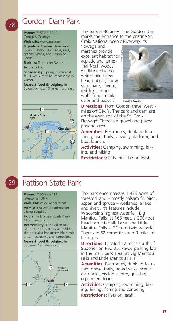
28 Gordon Dam ParkPhone: 715/395-1330 (Douglas County)Web site: www.nps.govSignature Species: TrumpeterSwan, Osprey, Bald Eagle, rails,grebes, vireos, and CommonLoons. Rarities: Trumpeter Swans. Hours: 24/7.Seasonality: Spring, summer &fall. Hwy. Y may be impassable inwinter. Nearest food & lodging: InSolon Springs, 10 miles northeast.
The park is 80 acres. The Gordon Dammarks the entrance to the pristine St.Croix National Scenic Riverway. Itsflowage andmarshes provideexcellent habitat foraquatic and terres-trial Northwoods’wildlife includingwhite-tailed deer,bear, bobcat, snow-shoe hare, coyote,red fox, timberwolf, fisher, mink,otter and beaver.Directions: From Gordon travel west 7miles on Cty. Y. The park and dam areon the west end of the St. CroixFlowage. There is a gravel and pavedparking area. Amenities: Restrooms, drinking foun-tain, gravel trails, viewing platform, andboat launch. Activities: Camping, swimming, bik-ing, and hiking. Restrictions: Pets must be on leash.
29 Pattison State ParkPhone: 715/399-3111 (Wisconsin DNR)Web site: www.wiparks.netAdmission: Vehicle admissionsticker required.Hours: Park is open daily 6am-11pm, year round. Accessibility: The trail to BigManitou Falls is partly accessible;the park also has accessible picnicareas, restrooms and campsites.Nearest food & lodging: InSuperior, 12 miles north.
The park encompasses 1,476 acres offorested land – mostly balsam fir, birch,aspen and spruce – wetlands, a lakeand rivers. It’s features include:Wisconsin’s highest waterfall, BigManitou Falls, at 165 feet, a 300-footbeach on Interfalls Lake, and LittleManitou Falls, a 31-foot twin waterfall.There are 62 campsites and 9 miles ofhiking trails.Directions: Located 12 miles south ofSuperior on Hw. 35. Paved parking lotsin the main park area, at Big ManitouFalls and Little Manitou Falls.Amenities: Restrooms, drinking foun-tain, gravel trails, boardwalks, scenicoverlooks, visitors center, gift shop,equipment loans.Activities: Camping, swimming, bik-ing, hiking, fishing and canoeing.Restrictions: Pets on leash.
53
53
Y
M
St. Croix Flowage
Barden Lake
Gordon
Gordon DamPark
To Sp
oo
ner
To Superior
BB
35
Black River
PattisonState Park
To S
up
erio
r
To D
anbu
ry
LittleManitouFalls
BigManitou
Falls
Tundra Swan.
MIK
EM
CD
OW
ELL
2288
30 Wisconsin PointPhone: 715/394-0270 (City of Superior)Web site: www.uncommondays.com/states/wi/places/wisconsinpoint.htmRarities: In the spring and fall,Jaegers and rare Sabine’s andFranklin’s Gulls visit the area. Hours: 24/7.Seasonality: Best during thespring and fall migrations.Accessibility: A paved road runsthe length of the point.Nearest food & lodging: InSuperior, 4 miles southwest.
2
53
Lake Superior
Allouez
Superior
To Eau Claire and Asland
To Duluth
Wisconsin Point
WISCONSIN POINT RD
MOCCASIN MIKE RD
The largest freshwater sand spit (3.5miles) in Wisconsin, the point formssheltered Allouez Bay and the St. LouisRiver Estuary on Lake Superior. It con-tains stands of old growth pine, beachdune communities and marsh openwater habitats. It is an important reststop for many migratory birds. Mostspecies of shorebirds are seen duringmigration, as are many uncommonsongbirds and raptors that rest on thepoint before continuing their journey. Directions: As you enter Superior onHwy. 2/53 turn east about 1.5 miles onMoccasin Mike Road, then northweston Wisconsin Point Road. There are anumber of parking areas in the 2.5-miles to the end of the point.Notes: The point also harbors severaluncommon dragonflies, the blackmeadowhawk and boreal snaketail.Franklin’s ground squirrels also live onthe point, but are not commonly seen.The beach can yield nice specimens ofLake superior agates.
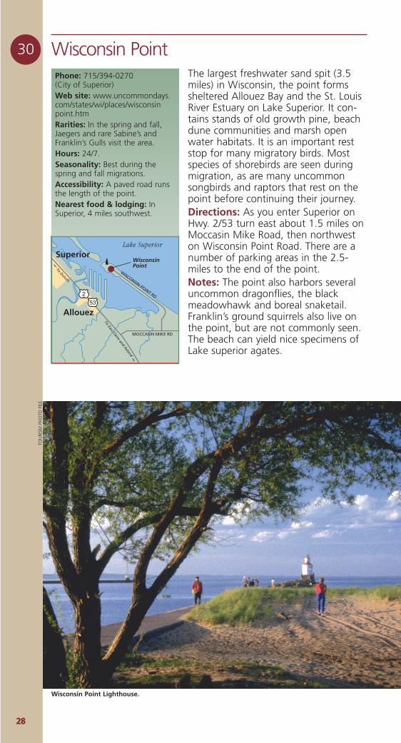
Wisconsin Point Lighthouse.
TOU
RISM
PH
OTO
FIL
E
2299
Florence County
31 Fox Maple Woods State Natural AreaAn outstanding 41-acre northern mesicforest surrounded on three sides by theWhisker Lake Wilderness Area. Canopytrees include old-growth sugar maple,basswood,hemlock, andyellow birch.Herbaceousplants arevery rich andcover the for-est in abun-dant springephemeralssuch asspring-beauty,yellow trout-lily and Dutchman’sbreeches. Exceptional in undisturbedareas.Directions: From Florence travel 10.5miles west on Hwy. 70 to a parkingarea north of the road, (1.1 miles westof where Hwy. 70 crosses WakefieldCreek).
Phone: 608/266-7012(WisconsinDNR)Web site: www.dnr.state.wi.us/org/land/er/snaSignature Species: Warblers andmany types of northern songbirds,hawks and owls.Hours: 24/7.Seasonality: Best in spring,summer, fall.Nearest food & lodging: InFlorence, ten miles east.
To Florence
Fox Maple Woods SNA
70
FR 2
150
Riley Lake
Camp Thirteen Lake
Whisker Lake
Boot Lake
Wa kefield
Cre ek
Ril
eyCr
eek
Black-capped Chickadee.
MIK
EM
CD
OW
ELL
Tucked into the far northeastern corner of the state,Florence County is about as wild and natural asWisconsin gets. With a countywide population ofjust 5,088 people (just over ten per square mile),Florence County is largely unpopulated.
Nearly half the county’snatural charm is preserved innational and county forests.The 7,400-acre Spread Eagle
Barrens State Natural Area is a birder’sparadise. The Pine, Popple and PeshtigoRivers are gems for whitewater canoeists.These exceptional wilderness componentscombine each autumn to produce one ofWisconsin’s best fall color opportunities.
The Wild Rivers Interpretive Center(888/889-0049,www.florencewisconsin.com) tells the storyof this unique corner of Wisconsin. Its dio-ramas, murals and interactive exhibits tellthe story of the county’s natural history.Stop at the center for driving directions, birding tips and tourisminformation.
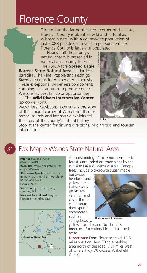
Trillium.
TOU
RISM
PH
OTO
FIL
E
3300
32 Lost LakeSituated on a beautiful, clear lake andsurrounded by old-growth forest, this1,000-acre site is ideal for the bird-watcher. Trails, including the “AssessorsTrail” - an historic interpretive trail, leadaround the lake and through majestichemlock and maple/birch hardwoodforest. The lake edge is a good place tosee and hear Great Blue Heron, loonsand ducks. Lost Lake is a NicoletNational Forest Breeding Bird Surveysite.Directions: From Florence travel west17 miles on Hwy. 70, then south onForest Road 2450 one mile, then south-east on Chipmunk Rapids Road onemile, then east and south 2 miles onForest Road 2156 (Halsey Lake Road) toLost Lake. Access the campground onFR 3774. Access the OrganizationalCamp complex on the south side of thelake. Gravel parking lot for 6 cars at the“Assessors Trail.” Amenities: 16-site campground at LostLake (open May 1-Oct 20), as well ascabins that can be rented mid-May thrumid-October (contact the Eagle Riveroffice of the Forest Service). Restrooms,drinking fountain, gravel trails.
Phone: 715/479-2827 (US Forest Service)Web site: www.fs.fed.us/r9/cnnfSignature Species: Blue-headedVireo, Pine Warbler, Black andWhite Warbler, and BlackburnianWarbler.Rarities: Boreal Chickadee, BaldEagle, Nashville Warbler, andOsprey.Admission: Fee to camp; if youdon’t camp, parking fee is $3/dayor $10 annual.Seasonality: Best in spring andsummer.Accessibility: Partial - one loop ofthe interpretive trail is wheelchairaccessible.Nearest food & lodging: InFlorence, 20 miles east.
Florence County
To Florence
Lost Lake
70
FR 2
450
CHIPMUNK
RAPIDS
ROA
D
Lost Lake Grub Hoe
Lake
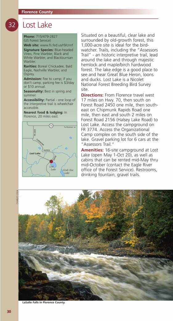
LaSalle Falls in Florence County.
CH
ARL
ES C
OO
K
3311
33 Spread Eagle Barrens State Natural AreaA 7,400-acre, state-owned barrens; anarea of undulating terrain with manysmall, clear lakes. Managed by fire, thebarrens are interrupted with patches ofmixed hardwood and conifer. The PineRiver, a state-designated wild river,splits the acreage. There are many dirtroads, ample gravel parking, and goodaccess.Directions: The heart of the barrens isabout 8 miles southeast of Florence.(For a map, stop at the Wild RiversInterpretive Center in Florence at thecorner of Hwys. 2 and 70/101.) Youcan access the northern portion of thebarrens by traveling east of Florence onHwys. 2/141, turn south on CondroskiRoad (2 miles east of Florence), or onEllwood Lake Road (7 miles east ofFlorence). You can access the southernportion of the barrens by travelingsouth of Florence 7 miles on Cty. N,then east on Fire Lane Road.
Phone: 888/889-0049 (Wild Rivers Interpretive Center)Web site:www.florencewisconsin.com/wricwww.dnr.state.wi.us/org/land/er/snaSignature Species: NorthernHarrier, Upland Sandpipers,Warbling Vireo.Seasonality: Best in spring,summer and fall; secondary roadsare not plowed in winter.Nearest food & lodging: InFlorence, 8 miles northwest.
To Spread Eagle
Spread EagleBarrens
CO
ND
RO
SKI R
D
2 141
N
Cosgrove Lake
Deadman
Creek
Florence
34 Whisker Lake Wilderness Area Phone: 715/479-2827 or715/528-4464 (US Forest Service)Web site: www.fs.fed.us/r9/cnnfRarities: White-winged Crossbilland Pine Grosbeaks in winter,Boreal Chickadees year-round.
A 7,500-acre federally designatedwilderness heavily forested with severalstreams and seven beautiful lakes.Some Black Spruce and alder swamp,hardwoods, big White and Red Pine,Aspen, and wetland. This area is walk-in camping only; no motorized ormechanized vehicles are allowed. It is aplace of true natural solitude.Directions: Located 11 miles west ofFlorence on Hwy 70, the tract bordersHwy. 70 and Forest Road 2150. Severalgraveled parking areas.Notes: This is a true wilderness area.Be prepared; bring a compass. Accessvia three different trails that all lead toor pass lakes.Restrictions: No motorized or mecha-nized vehicles.
To Florence
Whisker LakeWilderness Area
70
FR 2
150
Riley Lake
Camp Thirteen Lake
Whisker Lake
Wa kefield
Cre ek
Ril
eyCr
eek
3322
Forest County
35 Ed’s Lake National Recreation TrailPhone: 715/674-4481 (US Forest Service)Web site: www.fs.fed.us/r9/cnnfRarities: Loons on Ed’s Lake.Hours: 24/7.Nearest food & lodging: InCrandon, 8 miles west; orWabeno, 8 miles east.
To Crandon
Ed's LakeTrail
WLost Lake
Eds Lake
Roberts Lake
Enjoy six miles of hiking/skiing trail thatfollows several early 1900’s railroadgrades through a variety of foresttypes. The property’s 200 acres are hilly,rolling topography throughhemlock/hardwood forest that hassome scattered super-canopy whitepine, and spruce/tamarack/heath bog.Birds common to these communitiesinclude: Blackburnian Warbler, Blue-headed Vireo, Ovenbird, Hermit Thrush,Black-throated Green Warbler, PileatedWoodpecker, Brown Creeper, WinterWren, and Scarlet Tanager.Directions: From Crandon travel south-east about 8 miles on Cty. W. Look fora large sign on the north side of theroad. You’ll find a graveled parkingarea for about 12 cars.Amenities: Adirondack-style shelter atEd’s lake.
Forest County and its near neighbors are aptlynamed, for they encompass 650,000 acres of theChequamegon-Nicolet National Forest. Fully 75% ofthe county is national forestland, home to some ofWisconsin’s finest wilderness. With a total of10,024, the county population is just under tenpeople per square mile.
The Forest County Potawatomi Museumand Cultural Center (715-478-7474, www.fcpotawatomi.com)in Crandon offers visitors fourmain sections to tour: theHistory of the Potawatomi, aninteractive language exhibit, adisplay of different traditionalelements, and a display of theheritage of the present daytribe. Just east of Crandon, atLaona, you can travel back intime at the LumberjackSpecial Steam Train &Camp Five MuseumComplex (800/774-3414,www.camp5museum.org). This authentic 19th century loggingcamp, farm and store also offers fun steam train rides, pontoonand surrey rides, an animal corral and nature center.
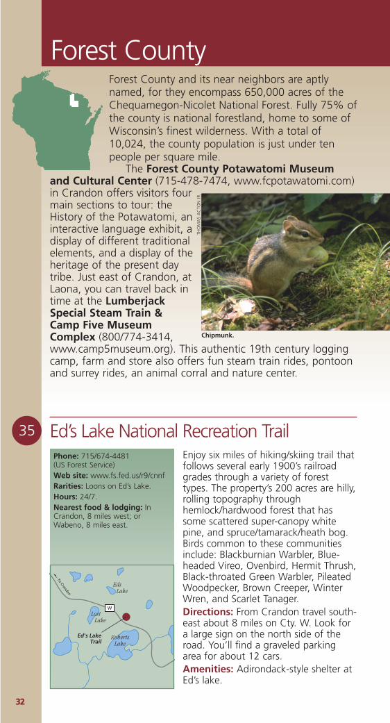
Chipmunk.
THO
MA
S A
CTO
N J
R.

3333
36 Franklin & Butternut Lakes Area
37 Giant White Pine Grove State Natural AreaPhone: 608/266-7012 (Wisconsin DNR)Web site: www.dnr.state.wi.us/org/land/er/snaSignature species: Blackburnianand Black-throated Blue Warblers,Pileated Woodpeckers.Rarities: Winter Wren, EveningGrosbeak, black bear and bobcat.Hours: 24/7.Seasonality: Best in spring,summer & fall.Nearest food & lodging: InThree Lakes, 12 miles west.
To Three Lakes
Giant White PineGrove SNA
32
GIANT PIN
E RD
FR 2414
JULIA
LAKERD
Julia Lake
Whitefish Lake
Phone: 715/479-2827 (US Forest Service)Web site: www.fs.fed.us/r9/cnnfSignature species: Bald Eagles.Rarities: Red-shouldered Hawk.Admission: Parking fee stickerrequired at the trailhead - $3/dailyor $10/annually.Hours: 24/7. Campground openMay- Oct.Accessibility: A short loop at thebeginning of the nature trail isaccessible by wheelchair. Nearest food & lodging: InEagle River, 12 miles west.
To EagleRiver
Franklin & Butternut
Lakes Area
70
Franklin Lake
Anvil Lake
Upper Ninemile Lake Butternut
Lake
FR 2178
RD
MILITA
RY
BUTTERNUTLA
KERD
To Florence
A wonderful 1,000-acre site for thehiker/birder. A 13-mile loop of trailwinds around a number of beautifuland remote lakes. A one-mile interpre-tive nature trail (brochures available onsite) takes you through a 400-year-oldhemlock and pine forest. A boardwalkcrosses an open bog. Birds in these for-est communities include: Woodpeckers,Wood Pewee, Winter Wren,Blackburnian Warbler, Cape MayWarbler, and Ovenbird. Waterbirds onand near the lake include Loon, GreatBlue Heron, Mallard, SpottedSandpiper, and Willow Flycatcher.Directions: From Eagle River travel east7.5 miles on Hwy. 70, turn south 2.5miles on Forest Road 2178 (MilitaryRoad), then east on Butternut LakeRoad (FR 2181) to the parking area atthe Franklin Nature Trail trailhead. You’llfind a parking lot for about 10 cars. Amenities: Restrooms, drinking foun-tain, gravel trails, boardwalks.
One of the best examples of mature,northern mesic forest in northeasternWisconsin. Located in the ForestService’s Headwaters Wilderness Area,the forest canopy of this 30-acre sitecontains largehemlock, sugarmaple, yellowbirch, and bass-wood. Huge whitepines, some morethan 3’ in diame-ter, tower abovethe forest.Directions: FromThree Lakes traveleast 4.7 miles on Hwy. 32; then 0.6mile east on Julia Lake Road; thensouth and east 3.1 miles on Scott LakeRoad (FR 2183); then northeast 1.6miles on Giant Pine Road (FR2414) to aparking area west of the road. A hikingtrail loops around a wetland andthrough the site.
Barred Owl.
MIK
EM
CD
OW
ELL
3344
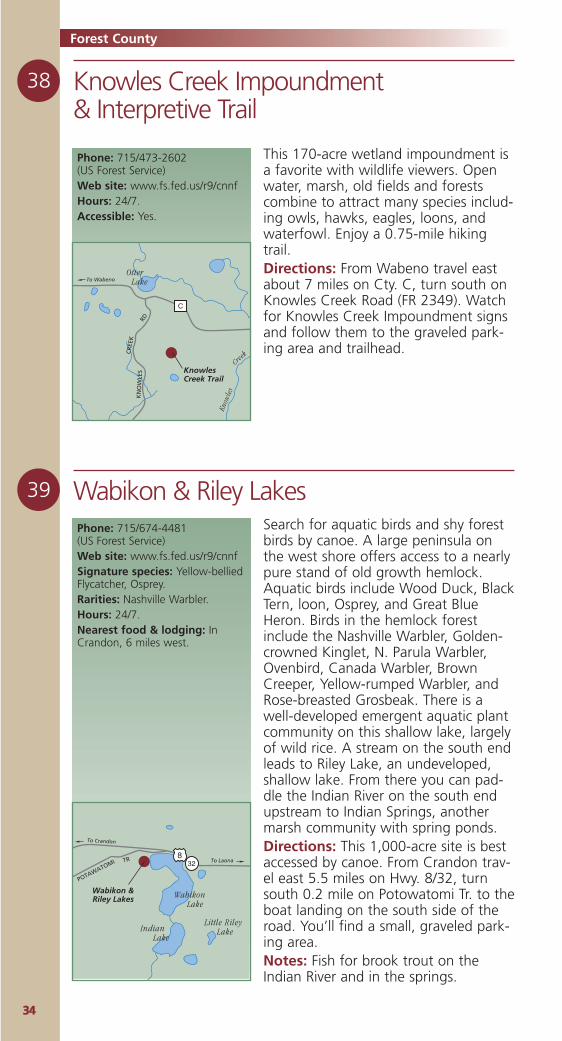
38 Knowles Creek Impoundment & Interpretive Trail
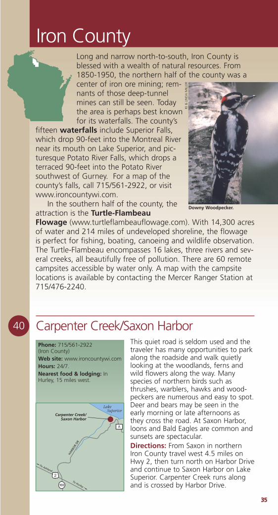
39 Wabikon & Riley Lakes
Forest County
Phone: 715/473-2602 (US Forest Service)Web site: www.fs.fed.us/r9/cnnfHours: 24/7.Accessible: Yes.
Know
les
Creek
To Wabeno
KnowlesCreek Trail
RD
CR
EEK
KN
OW
LES
C
Otter Lake
Phone: 715/674-4481 (US Forest Service)Web site: www.fs.fed.us/r9/cnnfSignature species: Yellow-belliedFlycatcher, Osprey.Rarities: Nashville Warbler.Hours: 24/7.Nearest food & lodging: InCrandon, 6 miles west.
To Laona
To Crandon
Wabikon &Riley Lakes
TR
POTAWATOMI 328
Wabikon Lake
Little Riley LakeIndian
Lake
This 170-acre wetland impoundment isa favorite with wildlife viewers. Openwater, marsh, old fields and forestscombine to attract many species includ-ing owls, hawks, eagles, loons, andwaterfowl. Enjoy a 0.75-mile hikingtrail.Directions: From Wabeno travel eastabout 7 miles on Cty. C, turn south onKnowles Creek Road (FR 2349). Watchfor Knowles Creek Impoundment signsand follow them to the graveled park-ing area and trailhead.
Search for aquatic birds and shy forestbirds by canoe. A large peninsula onthe west shore offers access to a nearlypure stand of old growth hemlock.Aquatic birds include Wood Duck, BlackTern, loon, Osprey, and Great BlueHeron. Birds in the hemlock forestinclude the Nashville Warbler, Golden-crowned Kinglet, N. Parula Warbler,Ovenbird, Canada Warbler, BrownCreeper, Yellow-rumped Warbler, andRose-breasted Grosbeak. There is awell-developed emergent aquatic plantcommunity on this shallow lake, largelyof wild rice. A stream on the south endleads to Riley Lake, an undeveloped,shallow lake. From there you can pad-dle the Indian River on the south endupstream to Indian Springs, anothermarsh community with spring ponds.Directions: This 1,000-acre site is bestaccessed by canoe. From Crandon trav-el east 5.5 miles on Hwy. 8/32, turnsouth 0.2 mile on Potowatomi Tr. to theboat landing on the south side of theroad. You’ll find a small, graveled park-ing area.Notes: Fish for brook trout on theIndian River and in the springs.
3355
Iron County
40 Carpenter Creek/Saxon HarborPhone: 715/561-2922 (Iron County)Web site: www.ironcountywi.comHours: 24/7.Nearest food & lodging: InHurley, 15 miles west.
Carpenter Creek/Saxon Harbor
A
To Hurley
To Ashland
169
2
HA
RBO
R D
R
Lake Superior
This quiet road is seldom used and thetraveler has many opportunities to parkalong the roadside and walk quietlylooking at the woodlands, ferns andwild flowers along the way. Manyspecies of northern birds such asthrushes, warblers, hawks and wood-peckers are numerous and easy to spot.Deer and bears may be seen in theearly morning or late afternoons asthey cross the road. At Saxon Harbor,loons and Bald Eagles are common andsunsets are spectacular.Directions: From Saxon in northernIron County travel west 4.5 miles onHwy 2, then turn north on Harbor Driveand continue to Saxon Harbor on LakeSuperior. Carpenter Creek runs alongand is crossed by Harbor Drive.
Long and narrow north-to-south, Iron County isblessed with a wealth of natural resources. From1850-1950, the northern half of the county was acenter of iron ore mining; rem-nants of those deep-tunnelmines can still be seen. Todaythe area is perhaps best knownfor its waterfalls. The county’s
fifteen waterfalls include Superior Falls,which drop 90-feet into the Montreal Rivernear its mouth on Lake Superior, and pic-turesque Potato River Falls, which drops aterraced 90-feet into the Potato Riversouthwest of Gurney. For a map of thecounty’s falls, call 715/561-2922, or visitwww.ironcountywi.com.
In the southern half of the county, theattraction is the Turtle-FlambeauFlowage (www.turtleflambeauflowage.com). With 14,300 acresof water and 214 miles of undeveloped shoreline, the flowageis perfect for fishing, boating, canoeing and wildlife observation.The Turtle-Flambeau encompasses 16 lakes, three rivers and sev-eral creeks, all beautifully free of pollution. There are 60 remotecampsites accessible by water only. A map with the campsitelocations is available by contacting the Mercer Ranger Station at715/476-2240.
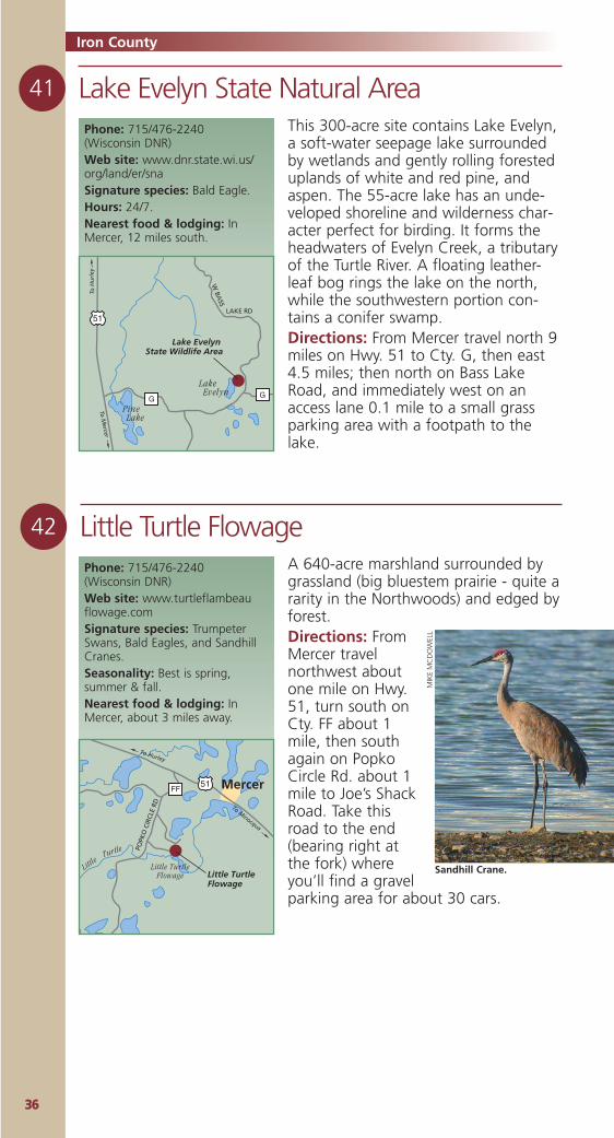
Downy Woodpecker.
RJ &
LIN
DA
MIL
LER
Phone: 715/476-2240 (Wisconsin DNR)Web site: www.dnr.state.wi.us/org/land/er/snaSignature species: Bald Eagle.Hours: 24/7.Nearest food & lodging: InMercer, 12 miles south.
3366
41
Iron County
This 300-acre site contains Lake Evelyn,a soft-water seepage lake surroundedby wetlands and gently rolling foresteduplands of white and red pine, andaspen. The 55-acre lake has an unde-veloped shoreline and wilderness char-acter perfect for birding. It forms theheadwaters of Evelyn Creek, a tributaryof the Turtle River. A floating leather-leaf bog rings the lake on the north,while the southwestern portion con-tains a conifer swamp. Directions: From Mercer travel north 9miles on Hwy. 51 to Cty. G, then east4.5 miles; then north on Bass LakeRoad, and immediately west on anaccess lane 0.1 mile to a small grassparking area with a footpath to thelake.
Lake Evelyn State Natural Area
Lake Evelyn State Wildlife Area
To M
ercer
To H
url
ey
51
G G
LAKE RD
W BA
SS
Pine Lake
Lake Evelyn
42 Little Turtle FlowageA 640-acre marshland surrounded bygrassland (big bluestem prairie - quite ararity in the Northwoods) and edged byforest. Directions: FromMercer travelnorthwest aboutone mile on Hwy.51, turn south onCty. FF about 1mile, then southagain on PopkoCircle Rd. about 1mile to Joe’s ShackRoad. Take thisroad to the end(bearing right atthe fork) whereyou’ll find a gravelparking area for about 30 cars.
Phone: 715/476-2240 (Wisconsin DNR)Web site: www.turtleflambeauflowage.comSignature species: TrumpeterSwans, Bald Eagles, and SandhillCranes.Seasonality: Best is spring,summer & fall.Nearest food & lodging: InMercer, about 3 miles away.
Little Turtle Flowage
To Hurley
To Minocqua
51FF
Little
Turtle POPK
O C
IRCL
E RD
Mercer
Little TurtleFlowage
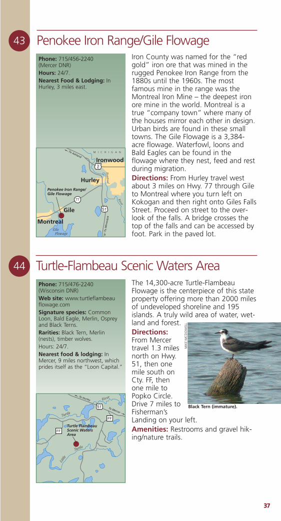
Sandhill Crane.
MIK
EM
CD
OW
ELL
3377
Penokee Iron Range/Gile Flowage43Iron County was named for the “redgold” iron ore that was mined in therugged Penokee Iron Range from the1880s until the 1960s. The mostfamous mine in the range was theMontreal Iron Mine – the deepest ironore mine in the world. Montreal is atrue “company town” where many ofthe houses mirror each other in design.Urban birds are found in these smalltowns. The Gile Flowage is a 3,384-acre flowage. Waterfowl, loons andBald Eagles can be found in theflowage where they nest, feed and restduring migration.Directions: From Hurley travel westabout 3 miles on Hwy. 77 through Gileto Montreal where you turn left onKokogan and then right onto Giles FallsStreet. Proceed on street to the over-look of the falls. A bridge crosses thetop of the falls and can be accessed byfoot. Park in the paved lot.
Phone: 715/456-2240 (Mercer DNR)Hours: 24/7.Nearest Food & Lodging: InHurley, 3 miles east.
Penokee Iron Range/Gile Flowage
To Ashland
To M
ino
cqu
a
77
51
2
Gile Flowage
Mon
treal
River
Montreal
Hurley
Gile
Ironwood
M I C H I G A N
44
Phone: 715/476-2240(Wisconsin DNR)Web site: www.turtleflambeauflowage.comSignature species: CommonLoon, Bald Eagle, Merlin, Ospreyand Black Terns.Rarities: Black Tern, Merlin(nests), timber wolves.Hours: 24/7.Nearest food & lodging: InMercer, 9 miles northwest, whichprides itself as the “Loon Capital.”
The 14,300-acre Turtle-FlambeauFlowage is the centerpiece of this stateproperty offering more than 2000 milesof undeveloped shoreline and 195islands. A truly wild area of water, wet-land and forest.Directions:From Mercertravel 1.3 milesnorth on Hwy.51, then onemile south onCty. FF, thenone mile toPopko Circle.Drive 7 miles toFisherman’sLanding on your left. Amenities: Restrooms and gravel hik-ing/nature trails.
Turtle-Flambeau Scenic Waters Area
Turtle FlambeauScenic Waters Area
To Mercer
To Hurley
51
FF
FF
Littl
e
Turtle
Turtle
River
Black Tern (immature).
MIK
EM
CD
OW
ELL
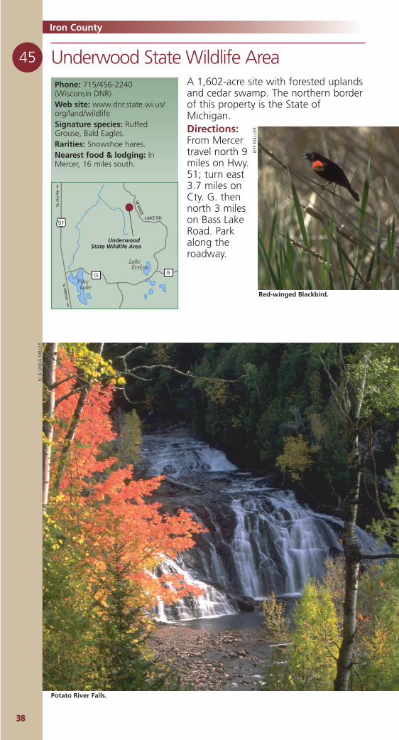
3388
Iron County
A 1,602-acre site with forested uplandsand cedar swamp. The northern borderof this property is the State ofMichigan.Directions:From Mercertravel north 9miles on Hwy.51; turn east3.7 miles onCty. G. thennorth 3 mileson Bass LakeRoad. Parkalong theroadway.
Phone: 715/456-2240 (Wisconsin DNR)Web site: www.dnr.state.wi.us/org/land/wildlifeSignature species: RuffedGrouse, Bald Eagles.Rarities: Snowshoe hares.Nearest food & lodging: InMercer, 16 miles south.
Underwood State Wildlife Area45
Underwood State Wildlife Area
To M
ercer
To H
url
ey
51
G G
LAKE RD
W BA
SS
Pine Lake
Lake Evelyn
JEFF
MIL
LLER
Potato River Falls.
RJ &
LIN
DA
MIL
LER
Red-winged Blackbird.
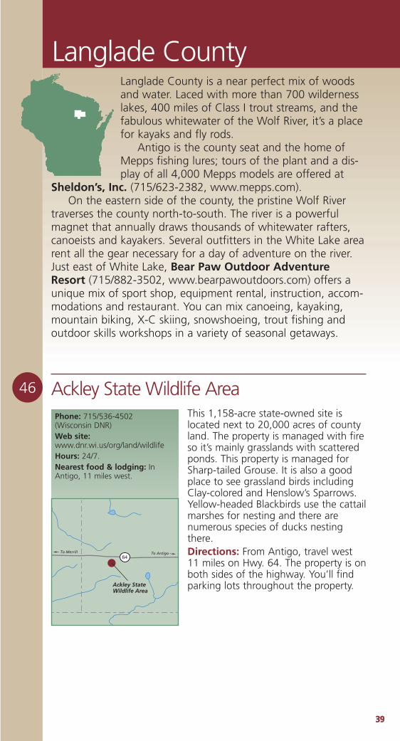
3399
Langlade County
46 Ackley State Wildlife AreaPhone: 715/536-4502 (Wisconsin DNR)Web site:www.dnr.wi.us/org/land/wildlifeHours: 24/7.Nearest food & lodging: InAntigo, 11 miles west.
Ackley State Wildlife Area
To Merrill To Antigo64
This 1,158-acre state-owned site islocated next to 20,000 acres of countyland. The property is managed with fireso it’s mainly grasslands with scatteredponds. This property is managed forSharp-tailed Grouse. It is also a goodplace to see grassland birds includingClay-colored and Henslow’s Sparrows.Yellow-headed Blackbirds use the cattailmarshes for nesting and there arenumerous species of ducks nestingthere.Directions: From Antigo, travel west11 miles on Hwy. 64. The property is onboth sides of the highway. You’ll findparking lots throughout the property.
Langlade County is a near perfect mix of woodsand water. Laced with more than 700 wildernesslakes, 400 miles of Class I trout streams, and thefabulous whitewater of the Wolf River, it’s a placefor kayaks and fly rods.
Antigo is the county seat and the home ofMepps fishing lures; tours of the plant and a dis-play of all 4,000 Mepps models are offered at
Sheldon’s, Inc. (715/623-2382, www.mepps.com).On the eastern side of the county, the pristine Wolf River
traverses the county north-to-south. The river is a powerfulmagnet that annually draws thousands of whitewater rafters,canoeists and kayakers. Several outfitters in the White Lake arearent all the gear necessary for a day of adventure on the river.Just east of White Lake, Bear Paw Outdoor AdventureResort (715/882-3502, www.bearpawoutdoors.com) offers aunique mix of sport shop, equipment rental, instruction, accom-modations and restaurant. You can mix canoeing, kayaking,mountain biking, X-C skiing, snowshoeing, trout fishing andoutdoor skills workshops in a variety of seasonal getaways.
4400
47
Peters Marsh State Wildlife Area
Langlade County
This 1,700-acre tract contains smallponds, marshland, grasslands andupland hardwood forest. It is an inter-esting mix of habitats that are attractiveto many mammals and birds. This is anexcellent place to find AmericanWoodcock in the early spring. SandhillCranes nest here and congregate in thefall. Hawks and a variety of owls can befound here, including the NorthernSaw-whet Owl.Directions: From Antigo travel northabout 3 miles on Hwy 45 to its junctionwith Cty. A. Follow Cty. A northeastabout 3 miles to a parking area. Thereare three parking areas on the property.
Phone: 715/536-4502 (WisconsinDNR)Web site: www.dnr.state.wi.us/org/land/wildlifeHours: 24/7.Nearest Food & Lodging: InAntigo, 8 miles southwest.
Peters MarshState Wildlife Area
A
Peters Lake
ICE AGE
SCENIC
TRAIL
To A
ntig
o
48
Bogus Swamp State Natural AreaPhone: 608/266-7012 (Wisconsin DNR)Web site: www.dnr.state.wi.us/org/land/er/snaSignature species: Palm Warbler,Lincoln’s Sparrow, NorthernHarrier, American Bittern.Rarities: Rare plants include lividsedge, hair-like sedge, andnorthern bog sedge.Hours: 24/7.Nearest food & lodging: InSummit Lake, 4 miles north.
Bogus Swamp SNA
4745
Summit Lake
Summit Lake
Greater Bass Lake
Deep Wood Lake
Bogus Swamp
RO
AD
FOR
EST
To Antigo
This 870-acre site owned by LangladeCounty is a combination of open wet-land types. The major feature is thebroad muskeg of stunted tamarack andblack spruce over a ground cover ofsphagnum mosses, sedges, and bogshrubs. Alongthe northernboundary flowsan intermittent,mineral-richstream linedwith emergentaquatic plantsand sedgemeadow. Southof this zone isan unusual“patternedbog,” one of only two well-developedexamples of this type in Wisconsin.Directions: From Summit Lake travelsouthwest 4 miles on Forest Road tothe western boundary of the site. Parkalong the road and walk east to thewetland.
Palm Warbler.
MIK
EM
CD
OW
ELL
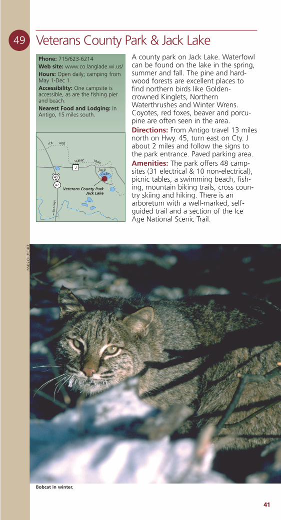
4411
49 Veterans County Park & Jack LakeA county park on Jack Lake. Waterfowlcan be found on the lake in the spring,summer and fall. The pine and hard-wood forests are excellent places tofind northern birds like Golden-crowned Kinglets, NorthernWaterthrushes and Winter Wrens.Coyotes, red foxes, beaver and porcu-pine are often seen in the area.Directions: From Antigo travel 13 milesnorth on Hwy. 45, turn east on Cty. Jabout 2 miles and follow the signs tothe park entrance. Paved parking area.Amenities: The park offers 48 camp-sites (31 electrical & 10 non-electrical),picnic tables, a swimming beach, fish-ing, mountain biking trails, cross coun-try skiing and hiking. There is anarboretum with a well-marked, self-guided trail and a section of the IceAge National Scenic Trail.
Phone: 715/623-6214Web site: www.co.langlade.wi.us/Hours: Open daily; camping fromMay 1-Dec 1.Accessibility: One campsite isaccessible, as are the fishing pierand beach.Nearest Food and Lodging: InAntigo, 15 miles south.
47
45
Veterans County ParkJack Lake
J Jack Lake
ICE AGE
SCENIC TRAIL
To A
nti
go
Bobcat in winter.
JAM
ES C
HU
RCH
ILL
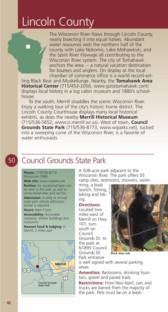
4422
Lincoln County
50 Council Grounds State ParkA 508-acre park adjacent to theWisconsin River. The park offers 55camp sites, restrooms, showers, swim-ming, a boatlaunch, fishing,biking and hik-ing.Directions:Located twomiles west ofMerrill on Hwy.107, turnsouth onCouncilGrounds Dr. tothe park atN1895 CouncilGrounds Dr.Park entranceis well signed with several parkingareas.Amenities: Restrooms, drinking foun-tain, gravel and paved trails.Restrictions: From Nov-April, cars andtrucks are barred from the majority ofthe park. Pets must be on a leash.
Phone: 715/536-8773(Wisconsin DNR)Web site: www.wiparks.netRarities: An occasional bear canbe seen in the park as well aswhite-tailed deer and red fox.Admission: A daily or annualstate park vehicle admissionsticker is required.Hours: 6am-11pm.Accessibility: Accessiblecampsite, shelter buildings andrestrooms.Nearest food & lodging: InMerrill, 2 miles east.
Council GroundsState Park
6464
107
107
107
K
Wisconsin
River
To W
ausa
u
Merrill
Black bear cub.
JEFF
PET
ERS
The Wisconsin River flows through Lincoln County,nearly bisecting it into equal halves. Abundantwater resources web the northern half of thecounty with Lake Nokomis, Lake Mohawksin, andthe Spirit River Flowage all contributing to theWisconsin River system. The city of Tomahawkanchors the area – a natural vacation destinationfor boaters and anglers. On display at the localchamber of commerce office is a world record-set-
ting Black Bear and Muskellunge. Nearby, the Tomahawk AreaHistorical Center (715/453-2056, www.gototomahawk.com)displays local history in a log cabin museum and 1880’s school-house.
To the south, Merrill straddles the scenic Wisconsin River.Enjoy a walking tour of the city’s historic home district. TheLincoln County Courthouse displays many local historicalexhibits, as does the nearby Merrill Historical Museum(715/536-5652, www.ci.merrill.wi.us). West of town, CouncilGrounds State Park (715/536-8773, www.wiparks.net), tuckedinto a sweeping curve of the Wisconsin River, is a favorite ofwater enthusiasts.
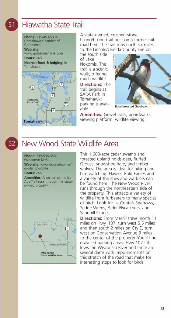
4433
51 Hiawatha State Trail
52 New Wood State Wildlife Area
A state-owned, crushed-stonehiking/biking trail built on a former rail-road bed. The trail runs north six milesto the Lincoln/Oneida County line onthe south sideof LakeNokomis. Thetrail is a scenicwalk, offeringmuch wildlife.Directions: Thetrail begins atSARA Park inTomahawk;parking is avail-able.Amenities: Gravel trails, boardwalks,viewing platform, wildlife viewing.
Phone: 715/453-5334(Tomahawk Chamber ofCommerce)Web site:www.gototomahawk.comHours: 24/7.Nearest food & lodging: InTomahawk.
This 1,600-acre cedar swamp andforested upland holds deer, RuffedGrouse, snowshoe hare, and timberwolves. The area is ideal for hiking andbird watching. Hawks, Bald Eagles anda variety of thrushes and warblers canbe found here. The New Wood Riverruns through the northeastern side ofthe property. This attracts a variety ofwildlife from furbearers to many speciesof birds. Look for Le Conte’s Sparrows,Sedge Wrens, Alder Flycatchers, andSandhill Cranes.Directions: From Merrill travel north 11miles on Hwy. 107, turn west 5.5 milesand then south 2 miles on Cty E, turnwest on Conservation Avenue 3 milesto the center of the property. You’ll findgraveled parking areas. Hwy 107 fol-lows the Wisconsin River and there areseveral dams with impoundments onthis stretch of the road that make forinteresting stops to look for birds.
Phone: 715/536-4502 (Wisconsin DNR)Web site: www.dnr.state.wi.us/org/land/wildlifeHours: 24/7.Amenities: A section of the IceAge Trail runs through this state-owned property.
New WoodState Wildlife Area
ERiver
New Wood
To Hwy 107
CONSERVATION AVE
HiawathaState Trail
A
51
88
A
To M
errill
To M
ino
cqu
a
Tomahawk
Lake Nokomis
RiverW isconsin
Rose-breasted Grosbeak.
MIK
EM
CD
OW
ELL
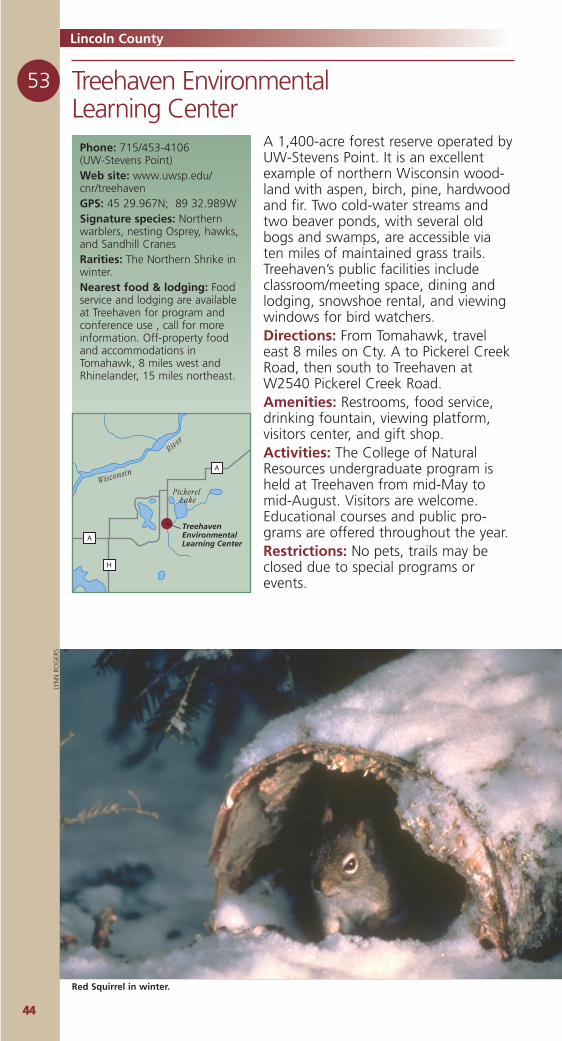
4444
53 Treehaven EnvironmentalLearning Center
Lincoln County
Phone: 715/453-4106 (UW-Stevens Point)Web site: www.uwsp.edu/cnr/treehavenGPS: 45 29.967N; 89 32.989WSignature species: Northernwarblers, nesting Osprey, hawks,and Sandhill CranesRarities: The Northern Shrike inwinter.Nearest food & lodging: Foodservice and lodging are availableat Treehaven for program andconference use , call for moreinformation. Off-property foodand accommodations inTomahawk, 8 miles west andRhinelander, 15 miles northeast.
A 1,400-acre forest reserve operated byUW-Stevens Point. It is an excellentexample of northern Wisconsin wood-land with aspen, birch, pine, hardwoodand fir. Two cold-water streams andtwo beaver ponds, with several oldbogs and swamps, are accessible viaten miles of maintained grass trails.Treehaven’s public facilities includeclassroom/meeting space, dining andlodging, snowshoe rental, and viewingwindows for bird watchers.Directions: From Tomahawk, traveleast 8 miles on Cty. A to Pickerel CreekRoad, then south to Treehaven atW2540 Pickerel Creek Road.Amenities: Restrooms, food service,drinking fountain, viewing platform,visitors center, and gift shop.Activities: The College of NaturalResources undergraduate program isheld at Treehaven from mid-May tomid-August. Visitors are welcome.Educational courses and public pro-grams are offered throughout the year.Restrictions: No pets, trails may beclosed due to special programs orevents.
TreehavenEnvironmentalLearning Center
A
A
H
Wisconsin
River
Pickerel Lake
Red Squirrel in winter.
LYN
N R
OG
ERS
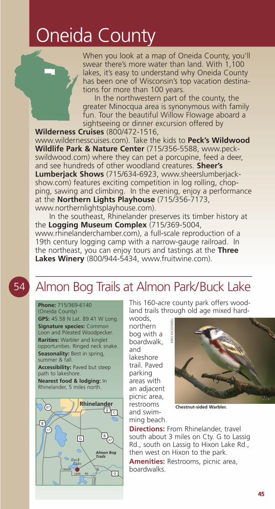
4455
Oneida County
54 Almon Bog Trails at Almon Park/Buck LakeThis 160-acre county park offers wood-land trails through old age mixed hard-woods,northernbog with aboardwalk,andlakeshoretrail. Pavedparkingareas withan adjacentpicnic area,restroomsand swim-ming beach.Directions: From Rhinelander, travelsouth about 3 miles on Cty. G to LassigRd., south on Lassig to Hixon Lake Rd.,then west on Hixon to the park. Amenities: Restrooms, picnic area,boardwalks.
Phone: 715/369-6140 (Oneida County)GPS: 45.58 N Lat. 89.41 W Long.Signature species: CommonLoon and Pileated Woodpecker.Rarities: Warbler and kingletopportunities. Ringed neck snake.Seasonality: Best in spring,summer & fall.Accessibility: Paved but steeppath to lakeshore. Nearest food & lodging: InRhinelander, 5 miles north.
8
8
BUS
8
17
47
47G
C
G
Rhinelander
Almon BogTrails
HIXON
LASS
IGRD
LAKE RD
Buck Lake
Chestnut-sided Warbler.
MIK
EM
CD
OW
ELL
When you look at a map of Oneida County, you’llswear there’s more water than land. With 1,100lakes, it’s easy to understand why Oneida Countyhas been one of Wisconsin’s top vacation destina-tions for more than 100 years.
In the northwestern part of the county, thegreater Minocqua area is synonymous with familyfun. Tour the beautiful Willow Flowage aboard asightseeing or dinner excursion offered by
Wilderness Cruises (800/472-1516,www.wildernesscuises.com). Take the kids to Peck’s WildwoodWildlife Park & Nature Center (715/356-5588, www.peck-swildwood.com) where they can pet a porcupine, feed a deer,and see hundreds of other woodland creatures. Sheer’sLumberjack Shows (715/634-6923, www.sheerslumberjack-show.com) features exciting competition in log rolling, chop-ping, sawing and climbing. In the evening, enjoy a performanceat the Northern Lights Playhouse (715/356-7173,www.northernlightsplayhouse.com).
In the southeast, Rhinelander preserves its timber history atthe Logging Museum Complex (715/369-5004,www.rhinelanderchamber.com), a full-scale reproduction of a19th century logging camp with a narrow-gauge railroad. Inthe northeast, you can enjoy tours and tastings at the ThreeLakes Winery (800/944-5434, www.fruitwine.com).
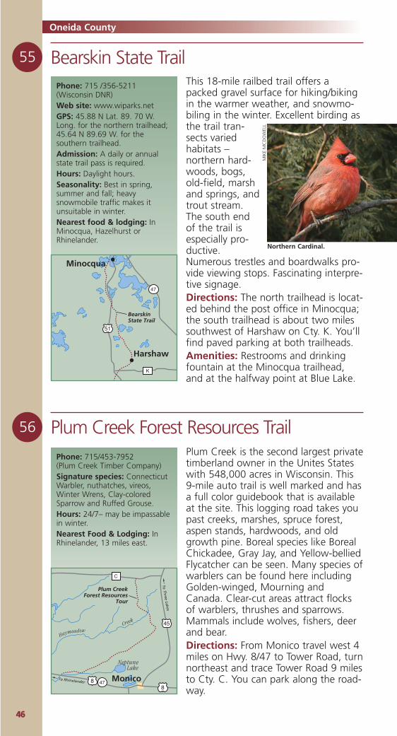
4466
55 Bearskin State Trail
56 Plum Creek Forest Resources Trail
Oneida County
This 18-mile railbed trail offers apacked gravel surface for hiking/bikingin the warmer weather, and snowmo-biling in the winter. Excellent birding asthe trail tran-sects variedhabitats –northern hard-woods, bogs,old-field, marshand springs, andtrout stream.The south endof the trail isespecially pro-ductive.Numerous trestles and boardwalks pro-vide viewing stops. Fascinating interpre-tive signage.Directions: The north trailhead is locat-ed behind the post office in Minocqua;the south trailhead is about two milessouthwest of Harshaw on Cty. K. You’llfind paved parking at both trailheads.Amenities: Restrooms and drinkingfountain at the Minocqua trailhead,and at the halfway point at Blue Lake.
Phone: 715 /356-5211(Wisconsin DNR)Web site: www.wiparks.netGPS: 45.88 N Lat. 89. 70 W.Long. for the northern trailhead;45.64 N 89.69 W. for thesouthern trailhead.Admission: A daily or annualstate trail pass is required.Hours: Daylight hours.Seasonality: Best in spring,summer and fall; heavysnowmobile traffic makes itunsuitable in winter.Nearest food & lodging: InMinocqua, Hazelhurst orRhinelander.
51
47
K
Harshaw
Minocqua
BearskinState Trail
Phone: 715/453-7952 (Plum Creek Timber Company)Signature species: ConnecticutWarbler, nuthatches, vireos,Winter Wrens, Clay-coloredSparrow and Ruffed Grouse. Hours: 24/7– may be impassablein winter.Nearest Food & Lodging: InRhinelander, 13 miles east.
To Rhinelander
To Th
ree Lakes
478
45
8
C
Monico
Plum CreekForest Resources
Tour
Creek
Haymeadow
Neptune Lake
Plum Creek is the second largest privatetimberland owner in the Unites Stateswith 548,000 acres in Wisconsin. This9-mile auto trail is well marked and hasa full color guidebook that is availableat the site. This logging road takes youpast creeks, marshes, spruce forest,aspen stands, hardwoods, and oldgrowth pine. Boreal species like BorealChickadee, Gray Jay, and Yellow-belliedFlycatcher can be seen. Many species ofwarblers can be found here includingGolden-winged, Mourning andCanada. Clear-cut areas attract flocksof warblers, thrushes and sparrows.Mammals include wolves, fishers, deerand bear. Directions: From Monico travel west 4miles on Hwy. 8/47 to Tower Road, turnnortheast and trace Tower Road 9 milesto Cty. C. You can park along the road-way.
Northern Cardinal.
MIK
EM
CD
OW
ELL
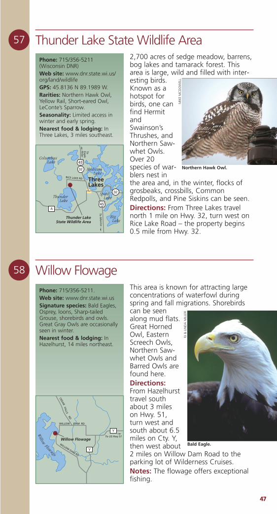
4477
58 Willow Flowage
57 Thunder Lake State Wildlife AreaPhone: 715/356-5211 (Wisconsin DNR)Web site: www.dnr.state.wi.us/org/land/wildlifeGPS: 45.8136 N 89.1989 W.Rarities: Northern Hawk Owl,Yellow Rail, Short-eared Owl,LeConte’s Sparrow.Seasonality: Limited access inwinter and early spring. Nearest food & lodging: InThree Lakes, 3 miles southeast.
To M
on
ico
To
Eagle
River
32
32
45
45
A
ThreeLakes
Thunder LakeState Wildlife Area
Thunder Lake
Columbus Lake
Big Lake
Spirit Lake
Medicine Lake
RICE LAKE RD
Phone: 715/356-5211.Web site: www.dnr.state.wi.usSignature species: Bald Eagles,Osprey, loons, Sharp-tailedGrouse, shorebirds and owls.Great Gray Owls are occasionallyseen in winter.Nearest food & lodging: InHazelhurst, 14 miles northeast.
Y
Y
Willow Flowage
WILLOW DAM RD
WILLOW DAM RD
CEDA
R
RD
FALLS
Willow
Flowage
To US Hwy 51
2,700 acres of sedge meadow, barrens,bog lakes and tamarack forest. Thisarea is large, wild and filled with inter-esting birds.Known as ahotspot forbirds, one canfind HermitandSwainson’sThrushes, andNorthern Saw-whet Owls.Over 20species of war-blers nest inthe area and, in the winter, flocks ofgrosbeaks, crossbills, CommonRedpolls, and Pine Siskins can be seen.Directions: From Three Lakes travelnorth 1 mile on Hwy. 32, turn west onRice Lake Road – the property begins0.5 mile from Hwy. 32.
This area is known for attracting largeconcentrations of waterfowl duringspring and fall migrations. Shorebirdscan be seenalong mud flats.Great HornedOwl, EasternScreech Owls,Northern Saw-whet Owls andBarred Owls arefound here.Directions:From Hazelhursttravel southabout 3 mileson Hwy. 51,turn west andsouth about 6.5miles on Cty. Y,then west about2 miles on Willow Dam Road to theparking lot of Wilderness Cruises. Notes: The flowage offers exceptionalfishing.
Northern Hawk Owl.
MIK
EM
CD
OW
ELL
Bald Eagle.
RJ &
LIN
DA
MIL
LER
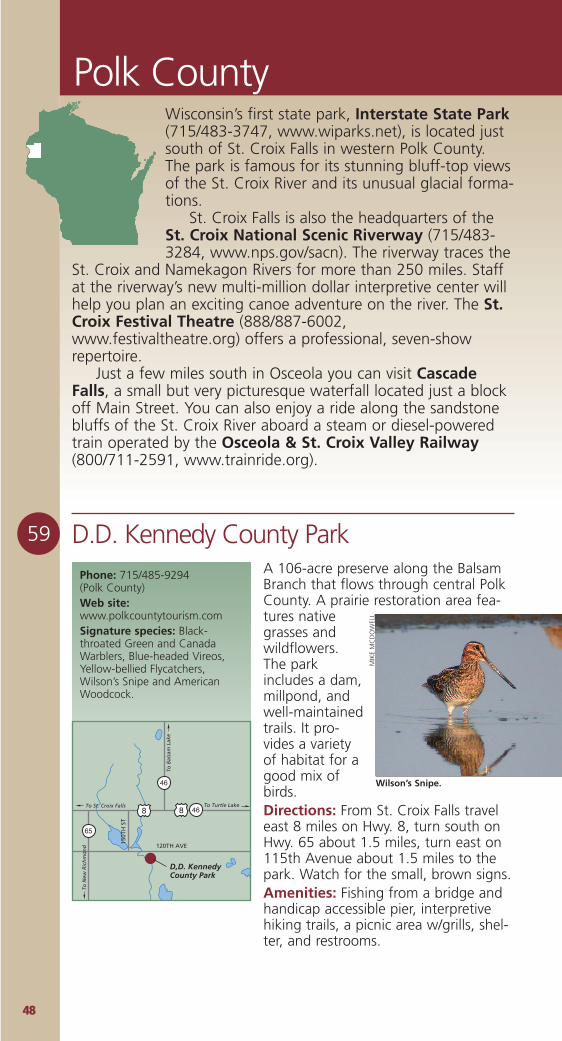
4488
Polk County
59 D.D. Kennedy County ParkA 106-acre preserve along the BalsamBranch that flows through central PolkCounty. A prairie restoration area fea-tures nativegrasses andwildflowers.The parkincludes a dam,millpond, andwell-maintainedtrails. It pro-vides a varietyof habitat for agood mix ofbirds.Directions: From St. Croix Falls traveleast 8 miles on Hwy. 8, turn south onHwy. 65 about 1.5 miles, turn east on115th Avenue about 1.5 miles to thepark. Watch for the small, brown signs.Amenities: Fishing from a bridge andhandicap accessible pier, interpretivehiking trails, a picnic area w/grills, shel-ter, and restrooms.
Phone: 715/485-9294 (Polk County)Web site:www.polkcountytourism.comSignature species: Black-throated Green and CanadaWarblers, Blue-headed Vireos,Yellow-bellied Flycatchers,Wilson’s Snipe and AmericanWoodcock.
D,D. KennedyCounty Park
To St. Croix Falls
To N
ew R
ich
mo
nd
To Turtle Lake
To B
alsa
m L
ake
46
65
46
88
120TH AVE150T
H S
T
Wilson’s Snipe.
MIK
EM
CD
OW
ELL
Wisconsin’s first state park, Interstate State Park(715/483-3747, www.wiparks.net), is located justsouth of St. Croix Falls in western Polk County.The park is famous for its stunning bluff-top viewsof the St. Croix River and its unusual glacial forma-tions.
St. Croix Falls is also the headquarters of theSt. Croix National Scenic Riverway (715/483-3284, www.nps.gov/sacn). The riverway traces the
St. Croix and Namekagon Rivers for more than 250 miles. Staffat the riverway’s new multi-million dollar interpretive center willhelp you plan an exciting canoe adventure on the river. The St.Croix Festival Theatre (888/887-6002,www.festivaltheatre.org) offers a professional, seven-showrepertoire.
Just a few miles south in Osceola you can visit CascadeFalls, a small but very picturesque waterfall located just a blockoff Main Street. You can also enjoy a ride along the sandstonebluffs of the St. Croix River aboard a steam or diesel-poweredtrain operated by the Osceola & St. Croix Valley Railway(800/711-2591, www.trainride.org).
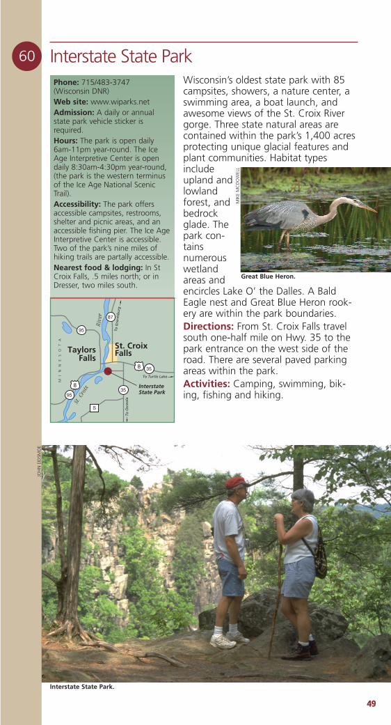
4499
60 Interstate State ParkWisconsin’s oldest state park with 85campsites, showers, a nature center, aswimming area, a boat launch, andawesome views of the St. Croix Rivergorge. Three state natural areas arecontained within the park’s 1,400 acresprotecting unique glacial features andplant communities. Habitat typesincludeupland andlowlandforest, andbedrockglade. Thepark con-tainsnumerouswetlandareas andencircles Lake O’ the Dalles. A BaldEagle nest and Great Blue Heron rook-ery are within the park boundaries.Directions: From St. Croix Falls travelsouth one-half mile on Hwy. 35 to thepark entrance on the west side of theroad. There are several paved parkingareas within the park.Activities: Camping, swimming, bik-ing, fishing and hiking.
Phone: 715/483-3747 (Wisconsin DNR)Web site: www.wiparks.netAdmission: A daily or annualstate park vehicle sticker isrequired.Hours: The park is open daily6am-11pm year-round. The IceAge Interpretive Center is opendaily 8:30am-4:30pm year-round,(the park is the western terminusof the Ice Age National ScenicTrail).Accessibility: The park offersaccessible campsites, restrooms,shelter and picnic areas, and anaccessible fishing pier. The Ice AgeInterpretive Center is accessible.Two of the park’s nine miles ofhiking trails are partally accessible.Nearest food & lodging: In StCroix Falls, .5 miles north; or inDresser, two miles south.
InterstateState Park
To O
sceo
la
To G
ran
tsb
urg
To Turtle Lake
S
95
35
87
35
95
8
8
St. C
roix
Riv
er
MI
NN
ES
OT
A
St. CroixFallsTaylors
Falls
Interstate State Park.
JOH
N E
IDSM
OE
MIK
EM
CD
OW
ELL
Great Blue Heron.
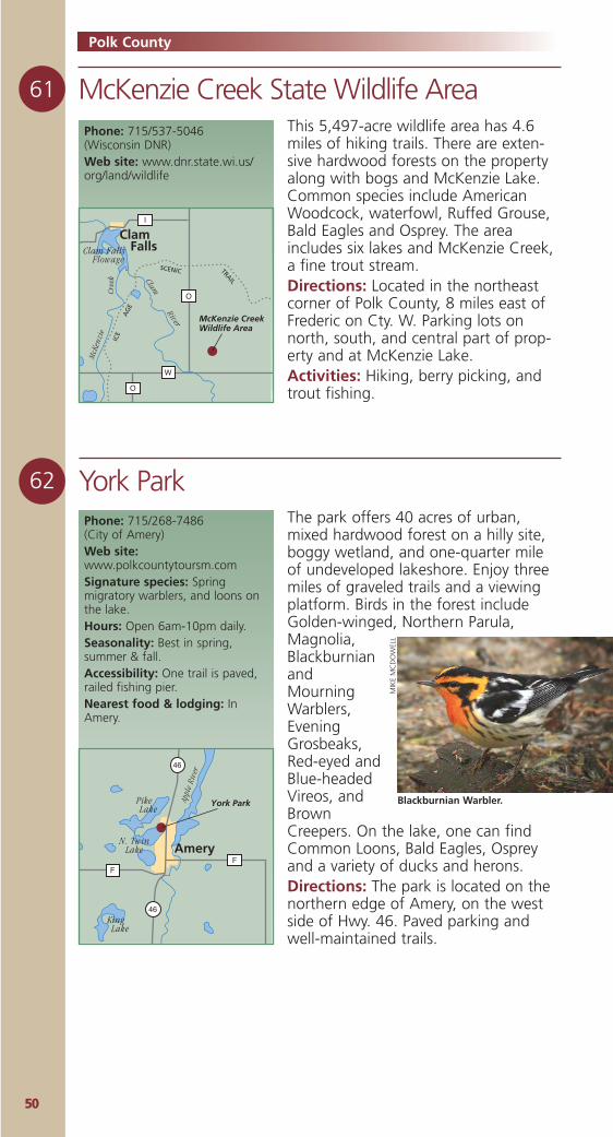
5500
62 York Park
Polk County
The park offers 40 acres of urban,mixed hardwood forest on a hilly site,boggy wetland, and one-quarter mileof undeveloped lakeshore. Enjoy threemiles of graveled trails and a viewingplatform. Birds in the forest includeGolden-winged, Northern Parula,Magnolia,BlackburnianandMourningWarblers,EveningGrosbeaks,Red-eyed andBlue-headedVireos, andBrownCreepers. On the lake, one can findCommon Loons, Bald Eagles, Ospreyand a variety of ducks and herons.Directions: The park is located on thenorthern edge of Amery, on the westside of Hwy. 46. Paved parking andwell-maintained trails.
Phone: 715/268-7486 (City of Amery)Web site:www.polkcountytoursm.comSignature species: Springmigratory warblers, and loons onthe lake.Hours: Open 6am-10pm daily.Seasonality: Best in spring,summer & fall.Accessibility: One trail is paved,railed fishing pier.Nearest food & lodging: InAmery.
FF
46
46
York Park
Amery
Pike Lake
N. TwinLake
King Lake
Appl
e Ri
ver
61 McKenzie Creek State Wildlife AreaPhone: 715/537-5046 (Wisconsin DNR)Web site: www.dnr.state.wi.us/org/land/wildlife
This 5,497-acre wildlife area has 4.6miles of hiking trails. There are exten-sive hardwood forests on the propertyalong with bogs and McKenzie Lake.Common species include AmericanWoodcock, waterfowl, Ruffed Grouse,Bald Eagles and Osprey. The areaincludes six lakes and McKenzie Creek,a fine trout stream.Directions: Located in the northeastcorner of Polk County, 8 miles east ofFrederic on Cty. W. Parking lots onnorth, south, and central part of prop-erty and at McKenzie Lake.Activities: Hiking, berry picking, andtrout fishing.
W
O
I
O
McKenzie CreekWildlife Area
ICE
AG
E
SCENIC TRAIL
Clam FallsClam Falls
Flowage
Clam
River
McK
enzi
eCr
eek
Blackburnian Warbler.
MIK
EM
CD
OW
ELL
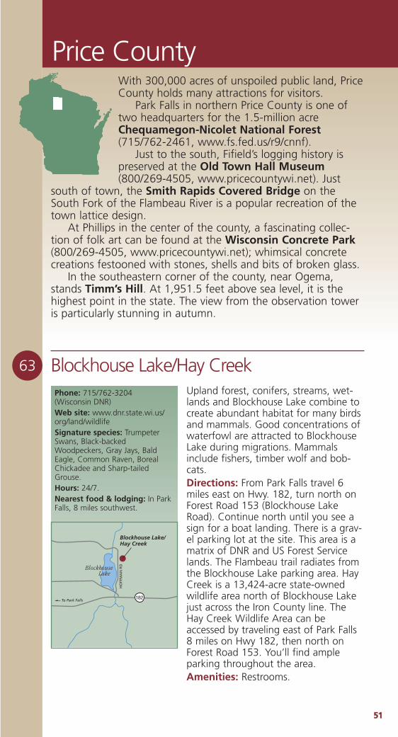
5511
Price County
63 Blockhouse Lake/Hay CreekPhone: 715/762-3204 (Wisconsin DNR)Web site: www.dnr.state.wi.us/org/land/wildlifeSignature species: TrumpeterSwans, Black-backedWoodpeckers, Gray Jays, BaldEagle, Common Raven, BorealChickadee and Sharp-tailedGrouse.Hours: 24/7.Nearest food & lodging: In ParkFalls, 8 miles southwest.
182
Blockhouse Lake
HO
FFM
AN
RD
To Park Falls
Blockhouse Lake/Hay Creek
Upland forest, conifers, streams, wet-lands and Blockhouse Lake combine tocreate abundant habitat for many birdsand mammals. Good concentrations ofwaterfowl are attracted to BlockhouseLake during migrations. Mammalsinclude fishers, timber wolf and bob-cats.Directions: From Park Falls travel 6miles east on Hwy. 182, turn north onForest Road 153 (Blockhouse LakeRoad). Continue north until you see asign for a boat landing. There is a grav-el parking lot at the site. This area is amatrix of DNR and US Forest Servicelands. The Flambeau trail radiates fromthe Blockhouse Lake parking area. HayCreek is a 13,424-acre state-ownedwildlife area north of Blockhouse Lakejust across the Iron County line. TheHay Creek Wildlife Area can beaccessed by traveling east of Park Falls8 miles on Hwy 182, then north onForest Road 153. You’ll find ampleparking throughout the area.Amenities: Restrooms.
With 300,000 acres of unspoiled public land, PriceCounty holds many attractions for visitors.
Park Falls in northern Price County is one oftwo headquarters for the 1.5-million acreChequamegon-Nicolet National Forest(715/762-2461, www.fs.fed.us/r9/cnnf).
Just to the south, Fifield’s logging history ispreserved at the Old Town Hall Museum(800/269-4505, www.pricecountywi.net). Just
south of town, the Smith Rapids Covered Bridge on theSouth Fork of the Flambeau River is a popular recreation of thetown lattice design.
At Phillips in the center of the county, a fascinating collec-tion of folk art can be found at the Wisconsin Concrete Park(800/269-4505, www.pricecountywi.net); whimsical concretecreations festooned with stones, shells and bits of broken glass.
In the southeastern corner of the county, near Ogema,stands Timm’s Hill. At 1,951.5 feet above sea level, it is thehighest point in the state. The view from the observation toweris particularly stunning in autumn.
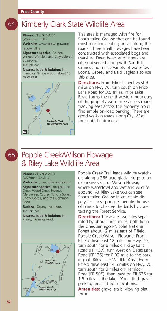
5522
64 Kimberly Clark State Wildlife Area
65 Popple Creek/Wilson Flowage & Riley Lake Wildlife Area
Price County
Popple Creek Trail leads wildlife watch-ers along a 266-acre glacial ridge to anexpansive vista of Wilson Flowagewhere waterfowl and wetland wildlifeabound. At Riley Lake you can seeSharp-tailed Grouse in courtship dis-plays in early spring. Schedule the useof blinds to observe the birds by con-tacting the Forest Service.Directions: These are two sites sepa-rated by about three miles; both lie inthe Chequamegon-Nicolet NationalForest about 12 miles east of Fifield.Popple Creek/Wilson Flowage: FromFifield drive east 12 miles on Hwy. 70,turn south for 6 miles on Riley LakeRoad (FR 137), turn west on Gates LakeRoad (FR136) for 0.02 mile to the park-ing lot. Riley Lake Wildlife Area: FromFifield drive east 14.5 miles on Hwy. 70,turn south for 3 miles on HemlockRoad (FR 505), then west on FR 536 for1.5 miles to the lake. You’ll find gravelparking areas at both locations.Amenities: gravel trails, viewing plat-form.
Phone: 715/762-2461 (US Forest Service)Web site: www.fs.fed.us/r9/cnntSignature species: Ring-neckedDuck, Wood Duck, HoodedMerganser, Osprey, Tundra Swan,Snow Goose, and the CommonLoon.Rarities: Osprey nest here.Hours: 24/7.Nearest food & lodging: InFifield, 16 miles west.
Riley LakeWildlife Area
Popple Creek/Wilson Flowage
To H
wy
70
HEM
LOC
K R
D
LAKE
RIL
EY
N GATES
FR 136
FR 1
37
FR 5
05
FR 536
LAKE RD
RD
Wilson Flowage
Riley Lake
This area is managed with fire forSharp-tailed Grouse that can be foundmost mornings eating gravel along theroads. Three small flowages have beenconstructed with associated bogs andmarshes. Deer, bears and fishers areoften observed along with SandhillCranes and a nice variety of waterfowl.Loons, Osprey and Bald Eagles also usethis area. Directions: From Fifield travel west 9miles on Hwy 70, turn south on PriceLake Road for 3.5 miles. Price LakeRoad forms the northwestern boundaryof the property with three access roadstracking east across the property. You’llfind ample on-road parking. There aregood walk-in roads along Cty. W atfour gated entrances.
Phone: 715/762-3204 (Wisconsin DNR)Web site: www.dnr.wi.gov/org/land/wildlifeSignature species: Golden-winged Warblers and Clay-coloredSparrows.Hours: 24/7.Nearest food & lodging: InFifield or Phillips – both about 12miles east.
Kimberly ClarkState Wildlife Area
To H
wy
70
W
PRIC
E
LAK
E
RD
Price Lake
Bass Lake
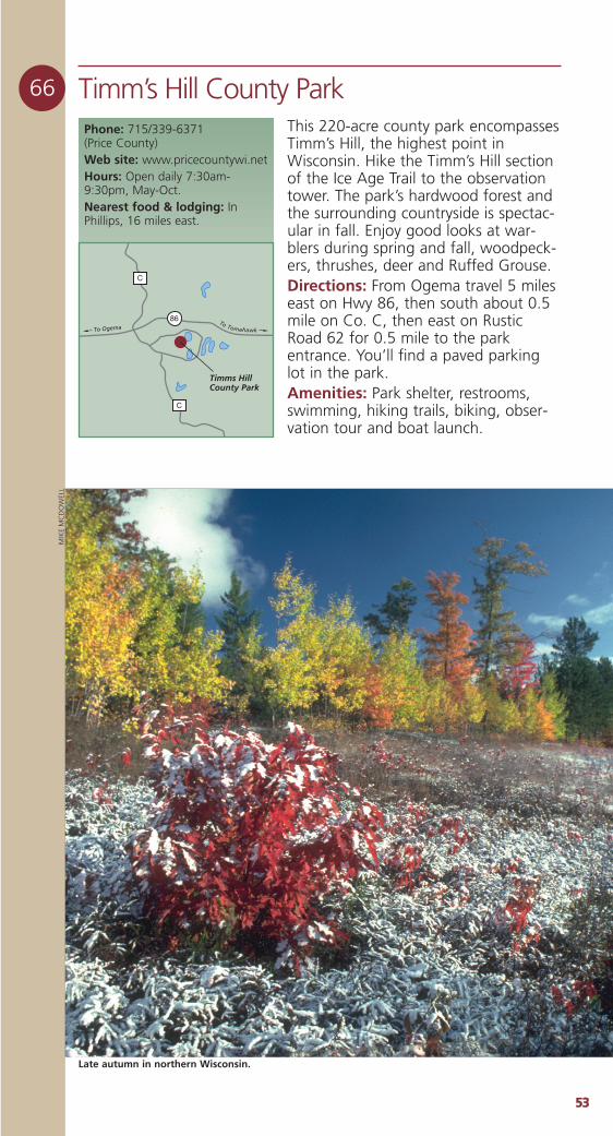
5533
66 Timm’s Hill County ParkThis 220-acre county park encompassesTimm’s Hill, the highest point inWisconsin. Hike the Timm’s Hill sectionof the Ice Age Trail to the observationtower. The park’s hardwood forest andthe surrounding countryside is spectac-ular in fall. Enjoy good looks at war-blers during spring and fall, woodpeck-ers, thrushes, deer and Ruffed Grouse.Directions: From Ogema travel 5 mileseast on Hwy 86, then south about 0.5mile on Co. C, then east on RusticRoad 62 for 0.5 mile to the parkentrance. You’ll find a paved parkinglot in the park. Amenities: Park shelter, restrooms,swimming, hiking trails, biking, obser-vation tour and boat launch.
Phone: 715/339-6371 (Price County)Web site: www.pricecountywi.netHours: Open daily 7:30am-9:30pm, May-Oct.Nearest food & lodging: InPhillips, 16 miles east.
Timms HillCounty Park
To Ogema86
C
C
To Tomahawk
Late autumn in northern Wisconsin.
MIK
EM
CD
OW
ELL
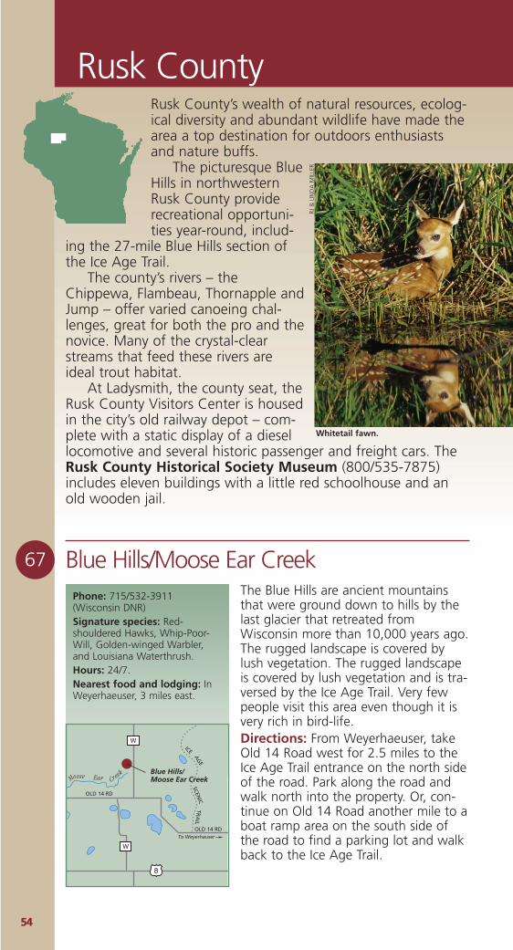
5544
Rusk County
67 Blue Hills/Moose Ear CreekPhone: 715/532-3911 (Wisconsin DNR)Signature species: Red-shouldered Hawks, Whip-Poor-Will, Golden-winged Warbler,and Louisiana Waterthrush.Hours: 24/7.Nearest food and lodging: InWeyerhaeuser, 3 miles east.
Blue Hills/Moose Ear Creek
To Weyerhauser
W
W
8
OLD 14 RD
OLD 14 RD
Creek
EarMoose
SCENIC
TRA
IL
ICE
AG
E
The Blue Hills are ancient mountainsthat were ground down to hills by thelast glacier that retreated fromWisconsin more than 10,000 years ago.The rugged landscape is covered bylush vegetation. The rugged landscapeis covered by lush vegetation and is tra-versed by the Ice Age Trail. Very fewpeople visit this area even though it isvery rich in bird-life.Directions: From Weyerhaeuser, takeOld 14 Road west for 2.5 miles to theIce Age Trail entrance on the north sideof the road. Park along the road andwalk north into the property. Or, con-tinue on Old 14 Road another mile to aboat ramp area on the south side ofthe road to find a parking lot and walkback to the Ice Age Trail.
Rusk County’s wealth of natural resources, ecolog-ical diversity and abundant wildlife have made thearea a top destination for outdoors enthusiastsand nature buffs.
The picturesque BlueHills in northwesternRusk County providerecreational opportuni-ties year-round, includ-
ing the 27-mile Blue Hills section ofthe Ice Age Trail.
The county’s rivers – theChippewa, Flambeau, Thornapple andJump – offer varied canoeing chal-lenges, great for both the pro and thenovice. Many of the crystal-clearstreams that feed these rivers areideal trout habitat.
At Ladysmith, the county seat, theRusk County Visitors Center is housedin the city’s old railway depot – com-plete with a static display of a diesellocomotive and several historic passenger and freight cars. TheRusk County Historical Society Museum (800/535-7875)includes eleven buildings with a little red schoolhouse and anold wooden jail.
Whitetail fawn.
RJ &
LIN
DA
MIL
LER
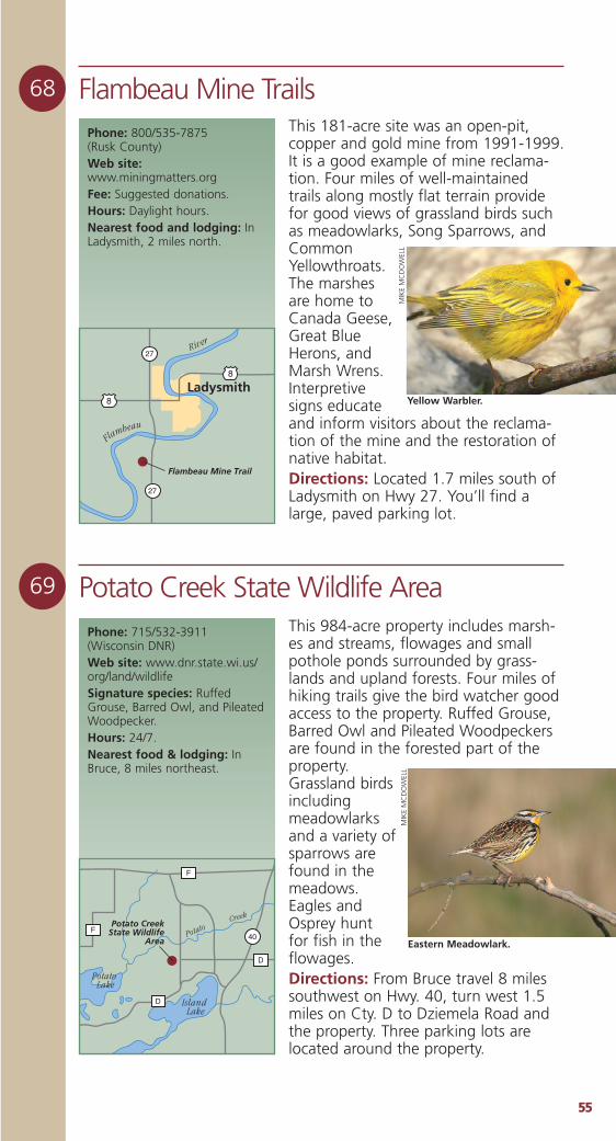
5555
68 Flambeau Mine Trails
69 Potato Creek State Wildlife Area
Phone: 800/535-7875 (Rusk County)Web site:www.miningmatters.org Fee: Suggested donations.Hours: Daylight hours.Nearest food and lodging: InLadysmith, 2 miles north.
8
8
27
27
Ladysmith
Flambeau Mine Trail
River
Flambeau
Phone: 715/532-3911 (Wisconsin DNR)Web site: www.dnr.state.wi.us/org/land/wildlifeSignature species: RuffedGrouse, Barred Owl, and PileatedWoodpecker.Hours: 24/7.Nearest food & lodging: InBruce, 8 miles northeast.
40
F
D
D
FPotato Creek
State WildlifeArea
Creek
Potato
Island Lake
Potato Lake
This 181-acre site was an open-pit,copper and gold mine from 1991-1999.It is a good example of mine reclama-tion. Four miles of well-maintainedtrails along mostly flat terrain providefor good views of grassland birds suchas meadowlarks, Song Sparrows, andCommonYellowthroats.The marshesare home toCanada Geese,Great BlueHerons, andMarsh Wrens.Interpretivesigns educateand inform visitors about the reclama-tion of the mine and the restoration ofnative habitat. Directions: Located 1.7 miles south ofLadysmith on Hwy 27. You’ll find alarge, paved parking lot.
This 984-acre property includes marsh-es and streams, flowages and smallpothole ponds surrounded by grass-lands and upland forests. Four miles ofhiking trails give the bird watcher goodaccess to the property. Ruffed Grouse,Barred Owl and Pileated Woodpeckersare found in the forested part of theproperty.Grassland birdsincludingmeadowlarksand a variety ofsparrows arefound in themeadows.Eagles andOsprey huntfor fish in theflowages.Directions: From Bruce travel 8 milessouthwest on Hwy. 40, turn west 1.5miles on Cty. D to Dziemela Road andthe property. Three parking lots arelocated around the property.
Yellow Warbler.M
IKE
MC
DO
WEL
L
Eastern Meadowlark.
MIK
EM
CD
OW
ELL
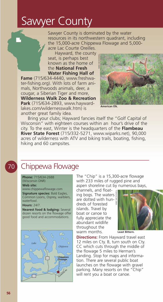
5566
Sawyer County
70 Chippewa FlowageThe “Chip” is a 15,300-acre flowagewith 233 miles of rugged pine andaspen shoreline cut by numerous bays,channels, and float-ing bogs. The watersare dotted with hun-dreds of forestedislands. Travel byboat or canoe tofully appreciate theabundant wildlifethroughout thewarm months.Directions: From Hayward travel east12 miles on Cty. B, turn south on Cty.CC which cuts through the middle ofthe flowage 5 miles to Herman’sLanding. Stop for maps and informa-tion. There are several public boatlaunches on the flowage with gravelparking. Many resorts on the “Chip”will rent you a boat or canoe.
Phone: 715/634-2688(Wisconsin DNR)Web site:www.chippewaflowage.comSignature species: Bald Eagles,Common Loons, Osprey, warblers,waterfowl.Hours: 24/7.Nearest food & lodging: Severaldozen resorts on the flowage offergood food and accommodations.
CC
CC
ChippewaFlowage
Lake Chippewa
To Hayw
ard
FLOW
AGE RD
Least Bittern.
MIK
EM
CD
OW
ELL
Sawyer County is dominated by the waterresources in its northwestern quadrant, includingthe 15,000-acre Chippewa Flowage and 5,000-acre Lac Courte Oreilles.
Hayward, the countyseat, is perhaps bestknown as the home ofthe National FreshWater Fishing Hall of
Fame (715/634-4440, www.freshwa-ter-fishing.org). With lots of farm ani-mals, Northwoods animals, deer, acougar, a Siberian Tiger and more,Wilderness Walk Zoo & RecreationPark (715/634-2893, www.hayward-lakes.com/wildernesswalk.htm) isanother great family idea.
Bring your clubs; Hayward fancies itself the “Golf Capital ofWisconsin” with eighteen courses within an hour’s drive of thecity. To the east, Winter is the headquarters of the FlambeauRiver State Forest (715/332-5271, www.wiparks.net), 90,000acres of wilderness with ATV and biking trails, boating, fishing,hiking and 60 campsites.
American Elk.
MIK
EM
CD
OW
ELL
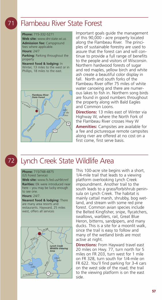
5577
72 Lynch Creek State Wildlife AreaThis 100-acre site begins with a short,1/4-mile trail that leads to a viewingplatform overlooking Lynch Creekimpoundment. Another trail to thesouth leads to a grass/forb/shrub penin-sula on Lynch Creek. The habitat ismainly cattail marsh, shrubby, bog wet-land, and stream with some red pineforest. Common avian species includethe Belted Kingfisher, snipe, flycatchers,swallows, warblers, rail, Great BlueHeron, bitterns, sandpipers, and manyducks. This is a site for a moonlit walk,since the trail is easy to follow andmany of the wetland birds are mostactive at night.Directions: From Hayward travel east20 miles on Hwy. 77, turn north for 5miles on FR 203, turn west for 1 mileon FR 328, turn south for 1/4-mile onFR 622. You’ll find parking for 3-4 carson the west side of the road; the trailto the viewing platform is on the eastside.
Phone: 715/748-4875 (US Forest Service)Web site: www.fs.fed.us/r9/cnnfRarities: Elk were introduced nearhere – you may be lucky enoughto see one.Hours: 24/7.Nearest food & lodging: Thereare many area resorts andrestaurants. Hayward, 25 mileswest, offers all services
Lynch CreekWildlife ViewingArea
To Hayward
FR 2
03
FR 328
FR 622
77
Ghost Lake
Teal Lake
Lynch
Cree
k
Important goals guide the managementof this 90,000 - acre property locatedalong the Flambeau River. The princi-ples of sustainable forestry are used toassure that the forest can and will con-tinue to provide a full range of benefitsto the people and visitors of Wisconsin.Northern hardwood forests of sugarand red maples, yellow birch and whiteash create a beautiful color display infall. North and south forks of theFlambeau River offer 75 miles of whitewater canoeing and there are numer-ous lakes to fish in. Northern song birdsare found in good numbers throughoutthe property along with Bald Eaglesand Common Loons.Directions: 13 miles east of Winter viaHighway W, where the North Fork ofthe Flambeau River crosses Hwy WAmenities: Campsites are available fora fee and picturesque remote campsitesalong river are offered at no cost on afirst come, first serve basis.
71
Phone: 715-332-5271Web site: www.dnr.state.wi.us Admission fee: Campgroundfees where applicable. Hours: 24/7Parking: Parking throughout thepropertyNearest food & lodging: InWinter, 13 miles to the west or inPhillips, 18 miles to the east.
W
M
Flambeau RiverState Forest
Rive
r
Flam
beau
Lake of the Pines
To Winter
Flambeau River State Forest
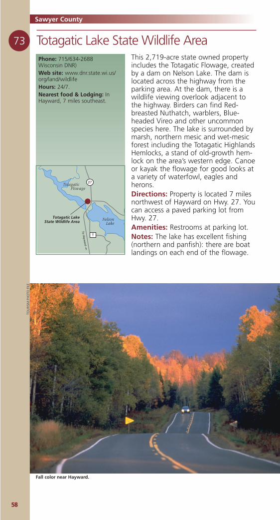
5588
73 Totagatic Lake State Wildlife AreaPhone: 715/634-2688 Wisconsin DNR)Web site: www.dnr.state.wi.us/org/land/wildlifeHours: 24/7.Nearest food & Lodging: InHayward, 7 miles southeast.
Totagatic LakeState Wildlife Area
To H
ayward
27
T
Nelson Lake
Totagatic Flowage
This 2,719-acre state owned propertyincludes the Totagatic Flowage, createdby a dam on Nelson Lake. The dam islocated across the highway from theparking area. At the dam, there is awildlife viewing overlook adjacent tothe highway. Birders can find Red-breasted Nuthatch, warblers, Blue-headed Vireo and other uncommonspecies here. The lake is surrounded bymarsh, northern mesic and wet-mesicforest including the Totagatic HighlandsHemlocks, a stand of old-growth hem-lock on the area’s western edge. Canoeor kayak the flowage for good looks ata variety of waterfowl, eagles andherons.Directions: Property is located 7 milesnorthwest of Hayward on Hwy. 27. Youcan access a paved parking lot fromHwy. 27.Amenities: Restrooms at parking lot.Notes: The lake has excellent fishing(northern and panfish): there are boatlandings on each end of the flowage.
Sawyer CountyTO
URI
SM P
HO
TO F
ILE
Fall color near Hayward.
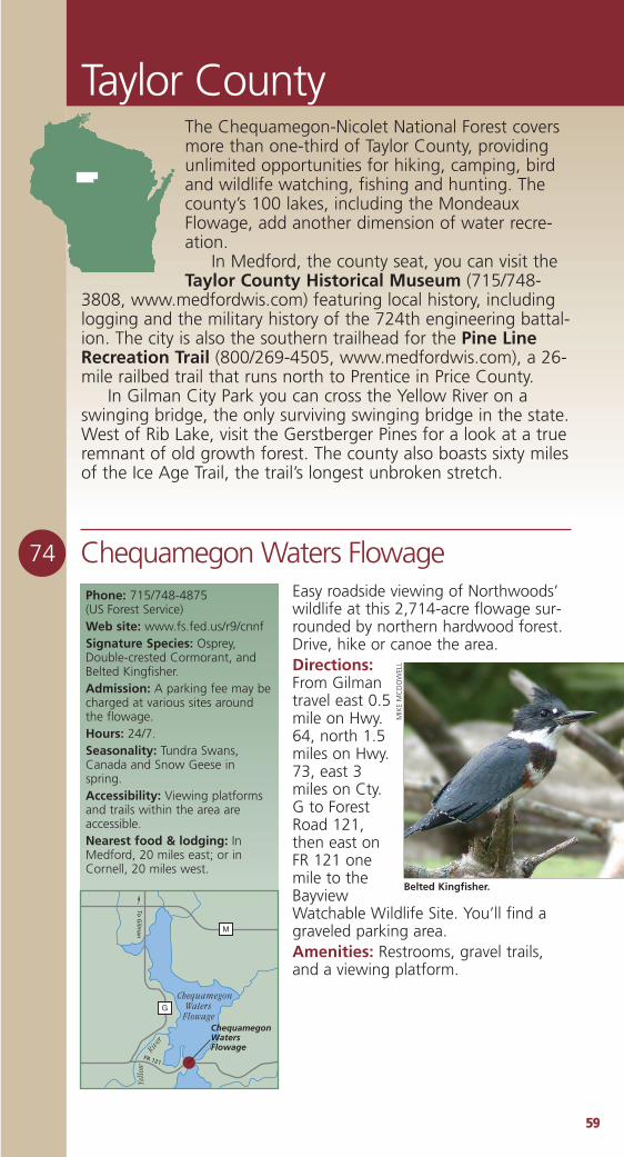
5599
Taylor County
74 Chequamegon Waters FlowageEasy roadside viewing of Northwoods’wildlife at this 2,714-acre flowage sur-rounded by northern hardwood forest.Drive, hike or canoe the area.Directions:From Gilmantravel east 0.5mile on Hwy.64, north 1.5miles on Hwy.73, east 3miles on Cty.G to ForestRoad 121,then east onFR 121 onemile to theBayviewWatchable Wildlife Site. You’ll find agraveled parking area.Amenities: Restrooms, gravel trails,and a viewing platform.
Phone: 715/748-4875 (US Forest Service)Web site: www.fs.fed.us/r9/cnnfSignature Species: Osprey,Double-crested Cormorant, andBelted Kingfisher.Admission: A parking fee may becharged at various sites aroundthe flowage.Hours: 24/7.Seasonality: Tundra Swans,Canada and Snow Geese inspring.Accessibility: Viewing platformsand trails within the area areaccessible.Nearest food & lodging: InMedford, 20 miles east; or inCornell, 20 miles west.
ChequamegonWatersFlowage
G
M
Chequamegon Waters Flowage
Yell
owRiv
er
FR 121
To G
ilman
The Chequamegon-Nicolet National Forest coversmore than one-third of Taylor County, providingunlimited opportunities for hiking, camping, birdand wildlife watching, fishing and hunting. Thecounty’s 100 lakes, including the MondeauxFlowage, add another dimension of water recre-ation.
In Medford, the county seat, you can visit theTaylor County Historical Museum (715/748-
3808, www.medfordwis.com) featuring local history, includinglogging and the military history of the 724th engineering battal-ion. The city is also the southern trailhead for the Pine LineRecreation Trail (800/269-4505, www.medfordwis.com), a 26-mile railbed trail that runs north to Prentice in Price County.
In Gilman City Park you can cross the Yellow River on aswinging bridge, the only surviving swinging bridge in the state.West of Rib Lake, visit the Gerstberger Pines for a look at a trueremnant of old growth forest. The county also boasts sixty milesof the Ice Age Trail, the trail’s longest unbroken stretch.
Belted Kingfisher.
MIK
EM
CD
OW
ELL
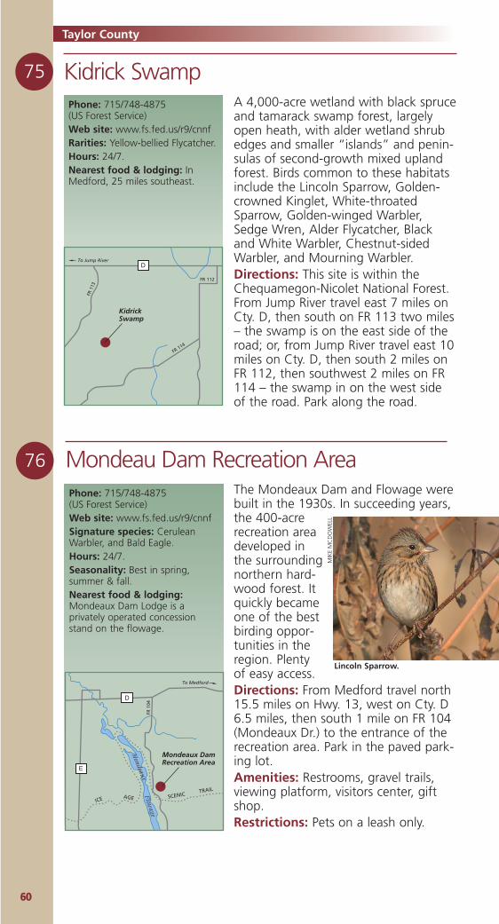
6600
Kidrick Swamp75
76 Mondeau Dam Recreation Area
Phone: 715/748-4875 (US Forest Service)Web site: www.fs.fed.us/r9/cnnfRarities: Yellow-bellied Flycatcher.Hours: 24/7.Nearest food & lodging: InMedford, 25 miles southeast.
KidrickSwamp
D
FR 114
FR 1
13
To Jump River
FR 112
A 4,000-acre wetland with black spruceand tamarack swamp forest, largelyopen heath, with alder wetland shrubedges and smaller “islands” and penin-sulas of second-growth mixed uplandforest. Birds common to these habitatsinclude the Lincoln Sparrow, Golden-crowned Kinglet, White-throatedSparrow, Golden-winged Warbler,Sedge Wren, Alder Flycatcher, Blackand White Warbler, Chestnut-sidedWarbler, and Mourning Warbler.Directions: This site is within theChequamegon-Nicolet National Forest.From Jump River travel east 7 miles onCty. D, then south on FR 113 two miles– the swamp is on the east side of theroad; or, from Jump River travel east 10miles on Cty. D, then south 2 miles onFR 112, then southwest 2 miles on FR114 – the swamp in on the west sideof the road. Park along the road.
Phone: 715/748-4875 (US Forest Service)Web site: www.fs.fed.us/r9/cnnfSignature species: CeruleanWarbler, and Bald Eagle.Hours: 24/7.Seasonality: Best in spring,summer & fall.Nearest food & lodging:Mondeaux Dam Lodge is aprivately operated concessionstand on the flowage.
Mondeaux DamRecreation Area
D
E
To Medford
FR 1
04
Mondeaux
Flowage
SCENICTRAIL
ICE AGE
The Mondeaux Dam and Flowage werebuilt in the 1930s. In succeeding years,the 400-acrerecreation areadeveloped inthe surroundingnorthern hard-wood forest. Itquickly becameone of the bestbirding oppor-tunities in theregion. Plentyof easy access.Directions: From Medford travel north15.5 miles on Hwy. 13, west on Cty. D6.5 miles, then south 1 mile on FR 104(Mondeaux Dr.) to the entrance of therecreation area. Park in the paved park-ing lot.Amenities: Restrooms, gravel trails,viewing platform, visitors center, giftshop.Restrictions: Pets on a leash only.
Lincoln Sparrow.
MIK
EM
CD
OW
ELL
Taylor County
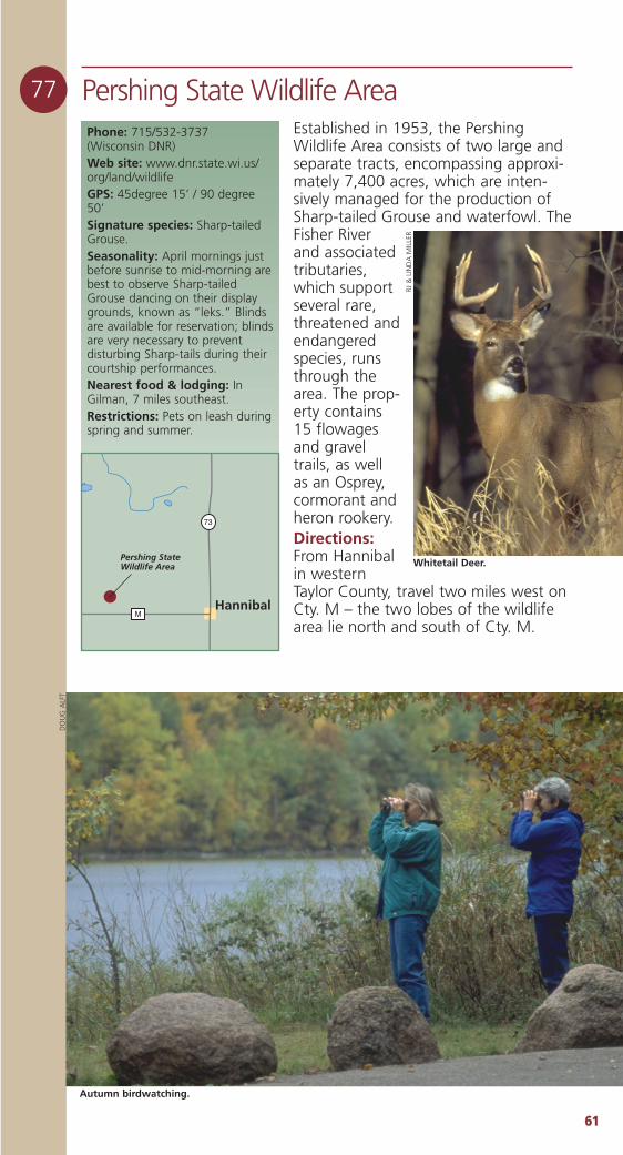
6611
77 Pershing State Wildlife AreaEstablished in 1953, the PershingWildlife Area consists of two large andseparate tracts, encompassing approxi-mately 7,400 acres, which are inten-sively managed for the production ofSharp-tailed Grouse and waterfowl. TheFisher Riverand associatedtributaries,which supportseveral rare,threatened andendangeredspecies, runsthrough thearea. The prop-erty contains15 flowagesand graveltrails, as wellas an Osprey,cormorant andheron rookery.Directions:From Hannibalin westernTaylor County, travel two miles west onCty. M – the two lobes of the wildlifearea lie north and south of Cty. M.
Phone: 715/532-3737 (Wisconsin DNR)Web site: www.dnr.state.wi.us/org/land/wildlifeGPS: 45degree 15’ / 90 degree50’Signature species: Sharp-tailedGrouse.Seasonality: April mornings justbefore sunrise to mid-morning arebest to observe Sharp-tailedGrouse dancing on their displaygrounds, known as “leks.” Blindsare available for reservation; blindsare very necessary to preventdisturbing Sharp-tails during theircourtship performances.Nearest food & lodging: InGilman, 7 miles southeast.Restrictions: Pets on leash duringspring and summer.
Pershing StateWildlife Area
M
73
Hannibal
Autumn birdwatching.
DO
UG
ALF
T
RJ &
LIN
DA
MIL
LER
Whitetail Deer.
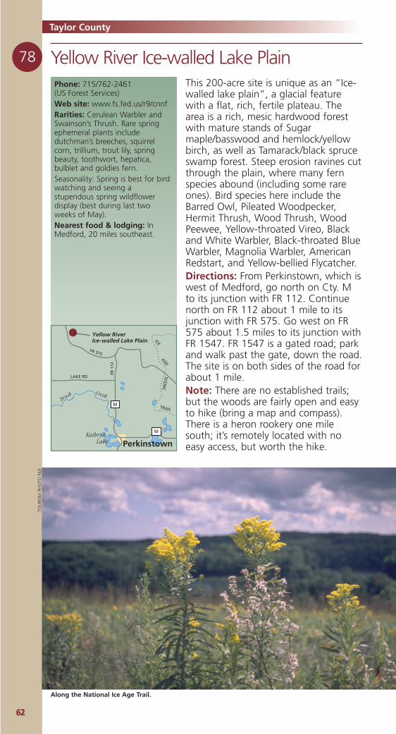
6622
78 Yellow River Ice-walled Lake PlainPhone: 715/762-2461 (US Forest Services)Web site: www.fs.fed.us/r9/cnnfRarities: Cerulean Warbler andSwainson’s Thrush. Rare springephemeral plants includedutchman’s breeches, squirrelcorn, trillium, trout lily, springbeauty, toothwort, hepatica,bulblet and goldies fern.Seasonality: Spring is best for birdwatching and seeing astupendous spring wildflowerdisplay (best during last twoweeks of May).Nearest food & lodging: InMedford, 20 miles southeast.
SCEN
IC
TRAIL
ICEAGE
Yellow RiverIce-walled Lake Plain
M
M
Perkinstown
FR 1
12
LAKE RD
FR 575
Kathryn Lake
Brush Creek
This 200-acre site is unique as an “Ice-walled lake plain”, a glacial featurewith a flat, rich, fertile plateau. Thearea is a rich, mesic hardwood forestwith mature stands of Sugarmaple/basswood and hemlock/yellowbirch, as well as Tamarack/black spruceswamp forest. Steep erosion ravines cutthrough the plain, where many fernspecies abound (including some rareones). Bird species here include theBarred Owl, Pileated Woodpecker,Hermit Thrush, Wood Thrush, WoodPeewee, Yellow-throated Vireo, Blackand White Warbler, Black-throated BlueWarbler, Magnolia Warbler, AmericanRedstart, and Yellow-bellied Flycatcher.Directions: From Perkinstown, which iswest of Medford, go north on Cty. Mto its junction with FR 112. Continuenorth on FR 112 about 1 mile to itsjunction with FR 575. Go west on FR575 about 1.5 miles to its junction withFR 1547. FR 1547 is a gated road; parkand walk past the gate, down the road.The site is on both sides of the road forabout 1 mile.Note: There are no established trails;but the woods are fairly open and easyto hike (bring a map and compass).There is a heron rookery one milesouth; it’s remotely located with noeasy access, but worth the hike.
Along the National Ice Age Trail.
TOU
RISM
PH
OTO
FIL
E
Taylor County
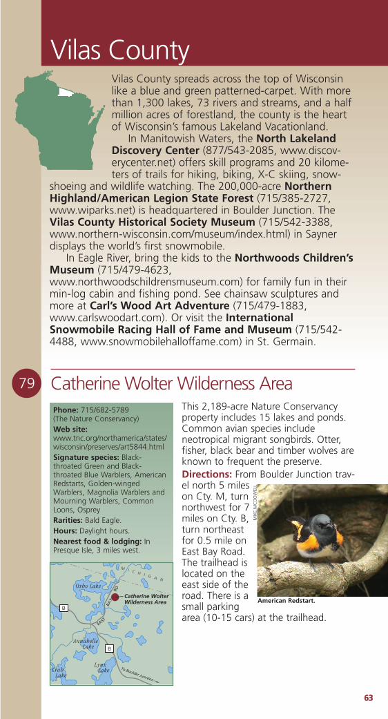
6633
Vilas County
79 Catherine Wolter Wilderness AreaThis 2,189-acre Nature Conservancyproperty includes 15 lakes and ponds.Common avian species includeneotropical migrant songbirds. Otter,fisher, black bear and timber wolves areknown to frequent the preserve.Directions: From Boulder Junction trav-el north 5 mileson Cty. M, turnnorthwest for 7miles on Cty. B,turn northeastfor 0.5 mile onEast Bay Road.The trailhead islocated on theeast side of theroad. There is asmall parkingarea (10-15 cars) at the trailhead.
Phone: 715/682-5789 (The Nature Conservancy) Web site:www.tnc.org/northamerica/states/wisconsin/preserves/art5844.htmlSignature species: Black-throated Green and Black-throated Blue Warblers, AmericanRedstarts, Golden-wingedWarblers, Magnolia Warblers andMourning Warblers, CommonLoons, OspreyRarities: Bald Eagle.Hours: Daylight hours.Nearest food & lodging: InPresque Isle, 3 miles west.
Catherine WolterWilderness Area
B
B
To Boulder Junction
EAST
RD
BAY
M I C H I G A N
Oxbo Lake
Annabelle Lake
Lynx LakeCrab
Lake
American Redstart.
MIK
EM
CD
OW
ELL
Vilas County spreads across the top of Wisconsinlike a blue and green patterned-carpet. With morethan 1,300 lakes, 73 rivers and streams, and a halfmillion acres of forestland, the county is the heartof Wisconsin’s famous Lakeland Vacationland.
In Manitowish Waters, the North LakelandDiscovery Center (877/543-2085, www.discov-erycenter.net) offers skill programs and 20 kilome-ters of trails for hiking, biking, X-C skiing, snow-
shoeing and wildlife watching. The 200,000-acre NorthernHighland/American Legion State Forest (715/385-2727,www.wiparks.net) is headquartered in Boulder Junction. TheVilas County Historical Society Museum (715/542-3388,www.northern-wisconsin.com/museum/index.html) in Saynerdisplays the world’s first snowmobile.
In Eagle River, bring the kids to the Northwoods Children’sMuseum (715/479-4623,www.northwoodschildrensmuseum.com) for family fun in theirmin-log cabin and fishing pond. See chainsaw sculptures andmore at Carl’s Wood Art Adventure (715/479-1883,www.carlswoodart.com). Or visit the InternationalSnowmobile Racing Hall of Fame and Museum (715/542-4488, www.snowmobilehalloffame.com) in St. Germain.
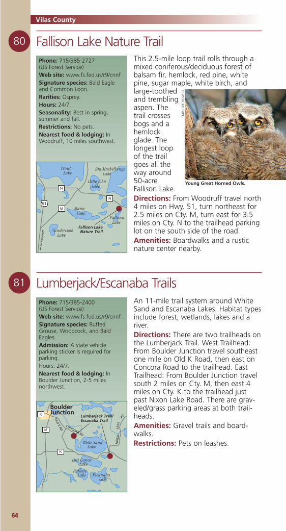
6644
Vilas County
80 Fallison Lake Nature Trail
81 Lumberjack/Escanaba Trails
Phone: 715/385-2727 (US Forest Service)Web site: www.fs.fed.us/r9/cnnfSignature species: Bald Eagleand Common Loon.Rarities: Osprey.Hours: 24/7.Seasonality: Best in spring,summer and fall.Restrictions: No pets.Nearest food & lodging: InWoodruff, 10 miles southwest.
This 2.5-mile loop trail rolls through amixed coniferous/deciduous forest ofbalsam fir, hemlock, red pine, whitepine, sugar maple, white birch, andlarge-toothedand tremblingaspen. Thetrail crossesbogs and ahemlockglade. Thelongest loopof the trailgoes all theway around50-acreFallison Lake.Directions: From Woodruff travel north4 miles on Hwy. 51, turn northeast for2.5 miles on Cty. M, turn east for 3.5miles on Cty. N to the trailhead parkinglot on the south side of the road.Amenities: Boardwalks and a rusticnature center nearby.
To W
oo
dru
ff
Fallison LakeNature Trail
51
N
N
M
Trout Lake
Little John Lake
Mann Lake
Vandercook Lake
Big Muskellunge Lake
Fallison Lake
An 11-mile trail system around WhiteSand and Escanaba Lakes. Habitat typesinclude forest, wetlands, lakes and ariver.Directions: There are two trailheads onthe Lumberjack Trail. West Trailhead:From Boulder Junction travel southeastone mile on Old K Road, then east onConcora Road to the trailhead. EastTrailhead: From Boulder Junction travelsouth 2 miles on Cty. M, then east 4miles on Cty. K to the trailhead justpast Nixon Lake Road. There are grav-eled/grass parking areas at both trail-heads.Amenities: Gravel trails and board-walks.Restrictions: Pets on leashes.
Phone: 715/385-2400 (US Forest Service)Web site: www.fs.fed.us/r9/cnnfSignature species: RuffedGrouse, Woodcock, and BaldEagles.Admission: A state vehicleparking sticker is required forparking.Hours: 24/7.Nearest food & lodging: InBoulder Junction, 2-5 milesnorthwest.
Lumberjack Trail/ Escanaba Trail
M
K
K
White Sand Lake
Lost Canoe Lake
Escanaba Lake
Pallette Lake
BoulderJunction
OLD
K RD
NIX
ON
RD
LAK
E
CONCORA RD
Young Great Horned Owls.M
IKE
MC
DO
WEL
L
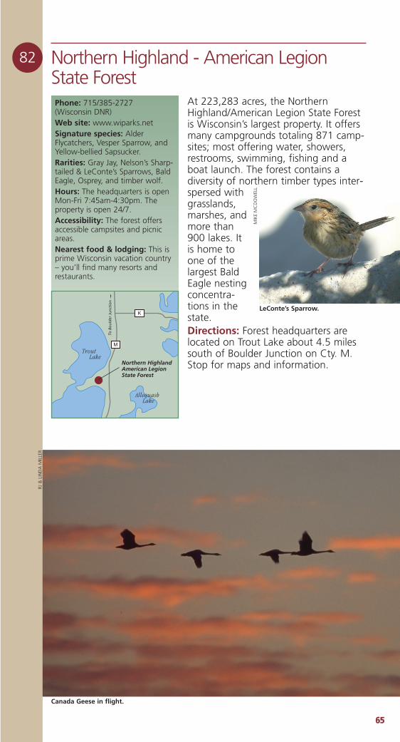
6655
82 Northern Highland - American LegionState Forest
At 223,283 acres, the NorthernHighland/American Legion State Forestis Wisconsin’s largest property. It offersmany campgrounds totaling 871 camp-sites; most offering water, showers,restrooms, swimming, fishing and aboat launch. The forest contains adiversity of northern timber types inter-spersed withgrasslands,marshes, andmore than900 lakes. Itis home toone of thelargest BaldEagle nestingconcentra-tions in thestate.Directions: Forest headquarters arelocated on Trout Lake about 4.5 milessouth of Boulder Junction on Cty. M.Stop for maps and information.
Phone: 715/385-2727 (Wisconsin DNR)Web site: www.wiparks.netSignature species: AlderFlycatchers, Vesper Sparrow, andYellow-bellied Sapsucker.Rarities: Gray Jay, Nelson’s Sharp-tailed & LeConte’s Sparrows, BaldEagle, Osprey, and timber wolf.Hours: The headquarters is openMon-Fri 7:45am-4:30pm. Theproperty is open 24/7.Accessibility: The forest offersaccessible campsites and picnicareas.Nearest food & lodging: This isprime Wisconsin vacation country– you’ll find many resorts andrestaurants.
Northern HighlandAmerican Legion State Forest
M
K
Trout Lake
Allequash Lake
To B
ou
lder
Ju
nct
ion
LeConte’s Sparrow.
MIK
EM
CD
OW
ELL
RJ &
LIN
DA
MIL
LER
Canada Geese in flight.
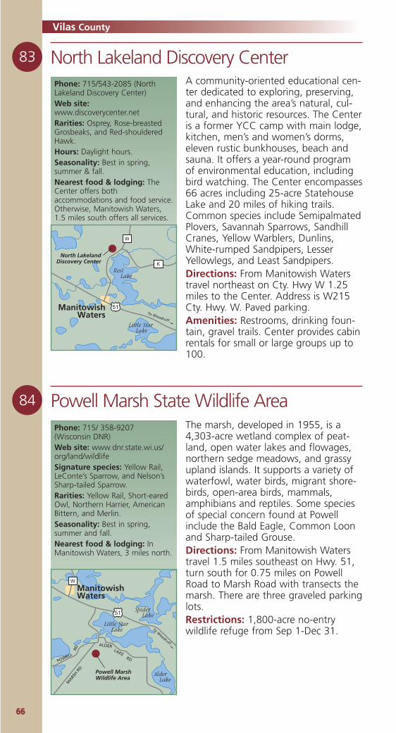
6666
North Lakeland Discovery Center83
A community-oriented educational cen-ter dedicated to exploring, preserving,and enhancing the area’s natural, cul-tural, and historic resources. The Centeris a former YCC camp with main lodge,kitchen, men’s and women’s dorms,eleven rustic bunkhouses, beach andsauna. It offers a year-round programof environmental education, includingbird watching. The Center encompasses66 acres including 25-acre StatehouseLake and 20 miles of hiking trails.Common species include SemipalmatedPlovers, Savannah Sparrows, SandhillCranes, Yellow Warblers, Dunlins,White-rumped Sandpipers, LesserYellowlegs, and Least Sandpipers.Directions: From Manitowish Waterstravel northeast on Cty. Hwy W 1.25miles to the Center. Address is W215Cty. Hwy. W. Paved parking.Amenities: Restrooms, drinking foun-tain, gravel trails. Center provides cabinrentals for small or large groups up to100.
Phone: 715/543-2085 (NorthLakeland Discovery Center)Web site:www.discoverycenter.netRarities: Osprey, Rose-breastedGrosbeaks, and Red-shoulderedHawk.Hours: Daylight hours.Seasonality: Best in spring,summer & fall.Nearest food & lodging: TheCenter offers bothaccommodations and food service.Otherwise, Manitowish Waters,1.5 miles south offers all services.
North LakelandDiscovery Center
W
K
51
Rest Lake
Little Star Lake
To Woodruff
ManitowishWaters
84 Powell Marsh State Wildlife AreaThe marsh, developed in 1955, is a4,303-acre wetland complex of peat-land, open water lakes and flowages,northern sedge meadows, and grassyupland islands. It supports a variety ofwaterfowl, water birds, migrant shore-birds, open-area birds, mammals,amphibians and reptiles. Some speciesof special concern found at Powellinclude the Bald Eagle, Common Loonand Sharp-tailed Grouse.Directions: From Manitowish Waterstravel 1.5 miles southeast on Hwy. 51,turn south for 0.75 miles on PowellRoad to Marsh Road with transects themarsh. There are three graveled parkinglots.Restrictions: 1,800-acre no-entrywildlife refuge from Sep 1-Dec 31.
Phone: 715/ 358-9207 (Wisconsin DNR)Web site: www.dnr.state.wi.us/org/land/wildlifeSignature species: Yellow Rail,LeConte’s Sparrow, and Nelson’sSharp-tailed Sparrow.Rarities: Yellow Rail, Short-earedOwl, Northern Harrier, AmericanBittern, and Merlin. Seasonality: Best in spring,summer and fall.Nearest food & lodging: InManitowish Waters, 3 miles north.
Powell Marsh Wildlife Area
W
51
Little Star Lake
Spider Lake
Alder Lake
To Woodruff
ManitowishWaters
MARS
H RD
POWELL
RD
ALDERLAKE
RD
Vilas County
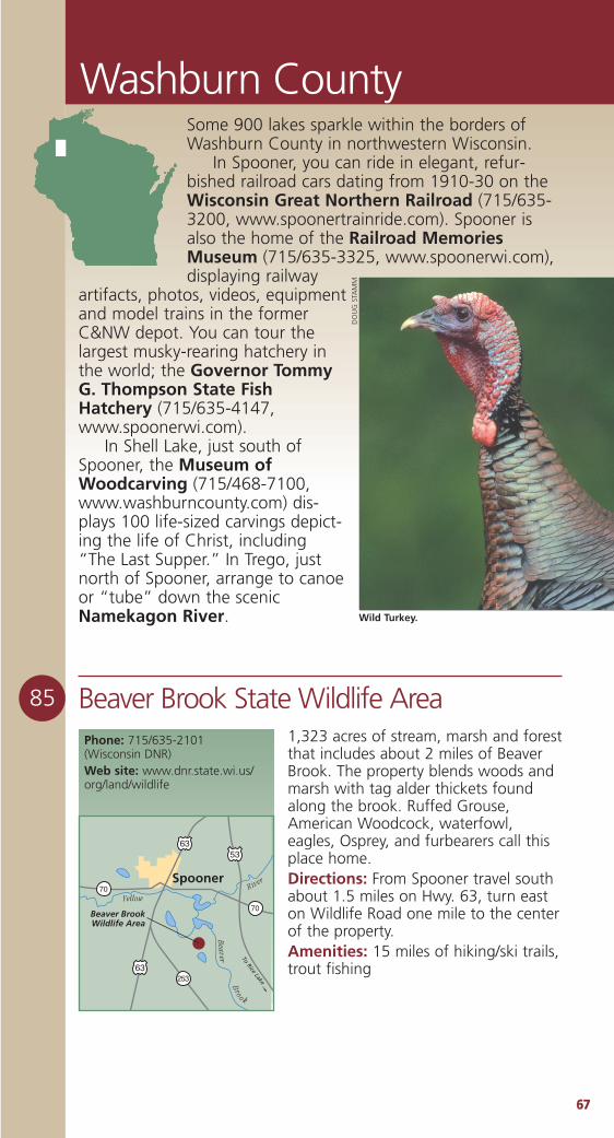
6677
Washburn County
85 Beaver Brook State Wildlife AreaPhone: 715/635-2101 (Wisconsin DNR)Web site: www.dnr.state.wi.us/org/land/wildlife
Beaver BrookWildlife Area
5363
63
70
70
253
Yellow
Beaver
River
To Rice Lake
Spooner
Bro o k
1,323 acres of stream, marsh and forestthat includes about 2 miles of BeaverBrook. The property blends woods andmarsh with tag alder thickets foundalong the brook. Ruffed Grouse,American Woodcock, waterfowl,eagles, Osprey, and furbearers call thisplace home.Directions: From Spooner travel southabout 1.5 miles on Hwy. 63, turn easton Wildlife Road one mile to the centerof the property. Amenities: 15 miles of hiking/ski trails,trout fishing
Some 900 lakes sparkle within the borders ofWashburn County in northwestern Wisconsin.
In Spooner, you can ride in elegant, refur-bished railroad cars dating from 1910-30 on theWisconsin Great Northern Railroad (715/635-3200, www.spoonertrainride.com). Spooner isalso the home of the Railroad MemoriesMuseum (715/635-3325, www.spoonerwi.com),displaying railway
artifacts, photos, videos, equipmentand model trains in the formerC&NW depot. You can tour thelargest musky-rearing hatchery inthe world; the Governor TommyG. Thompson State FishHatchery (715/635-4147,www.spoonerwi.com).
In Shell Lake, just south ofSpooner, the Museum ofWoodcarving (715/468-7100,www.washburncounty.com) dis-plays 100 life-sized carvings depict-ing the life of Christ, including“The Last Supper.” In Trego, justnorth of Spooner, arrange to canoeor “tube” down the scenicNamekagon River.
DO
UG
STA
MM
Wild Turkey.
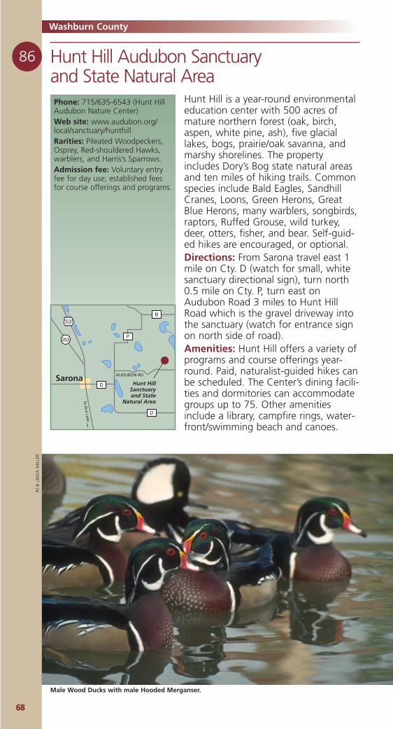
6688
Washburn County
86 Hunt Hill Audubon Sanctuary and State Natural Area Phone: 715/635-6543 (Hunt HillAudubon Nature Center)Web site: www.audubon.org/local/sanctuary/hunthillRarities: Pileated Woodpeckers,Osprey, Red-shouldered Hawks,warblers, and Harris’s Sparrows. Admission fee: Voluntary entryfee for day use; established feesfor course offerings and programs.
53
253P
B
D
D
To R
ice Lake
Sarona AUDUBON RD
Hunt HillSanctuaryand State
Natural Area
Hunt Hill is a year-round environmentaleducation center with 500 acres ofmature northern forest (oak, birch,aspen, white pine, ash), five glaciallakes, bogs, prairie/oak savanna, andmarshy shorelines. The propertyincludes Dory’s Bog state natural areasand ten miles of hiking trails. Commonspecies include Bald Eagles, SandhillCranes, Loons, Green Herons, GreatBlue Herons, many warblers, songbirds,raptors, Ruffed Grouse, wild turkey,deer, otters, fisher, and bear. Self-guid-ed hikes are encouraged, or optional.Directions: From Sarona travel east 1mile on Cty. D (watch for small, whitesanctuary directional sign), turn north0.5 mile on Cty. P, turn east onAudubon Road 3 miles to Hunt HillRoad which is the gravel driveway intothe sanctuary (watch for entrance signon north side of road).Amenities: Hunt Hill offers a variety ofprograms and course offerings year-round. Paid, naturalist-guided hikes canbe scheduled. The Center’s dining facili-ties and dormitories can accommodategroups up to 75. Other amenitiesinclude a library, campfire rings, water-front/swimming beach and canoes.
Male Wood Ducks with male Hooded Merganser.
RJ &
LIN
DA
MIL
LER
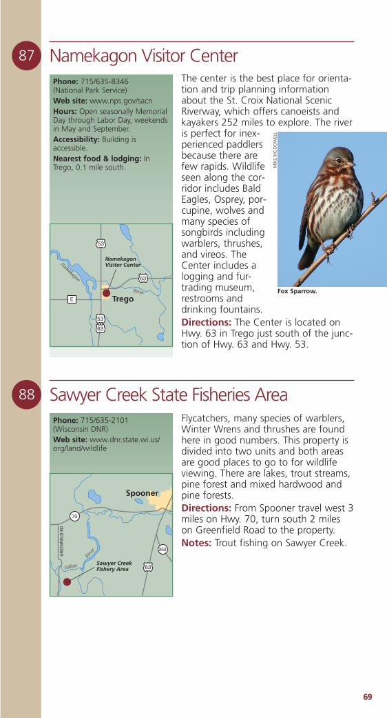
6699
88 Sawyer Creek State Fisheries AreaFlycatchers, many species of warblers,Winter Wrens and thrushes are foundhere in good numbers. This property isdivided into two units and both areasare good places to go to for wildlifeviewing. There are lakes, trout streams,pine forest and mixed hardwood andpine forests.Directions: From Spooner travel west 3miles on Hwy. 70, turn south 2 mileson Greenfield Road to the property.Notes: Trout fishing on Sawyer Creek.
Phone: 715/635-2101 (Wisconsin DNR)Web site: www.dnr.state.wi.us/org/land/wildlife
Sawyer CreekFishery Area 63
70
253
Yellow
River
Spooner
GR
EEN
FIEL
D R
D87 Namekagon Visitor Center
The center is the best place for orienta-tion and trip planning informationabout the St. Croix National ScenicRiverway, which offers canoeists andkayakers 252 miles to explore. The riveris perfect for inex-perienced paddlersbecause there arefew rapids. Wildlifeseen along the cor-ridor includes BaldEagles, Osprey, por-cupine, wolves andmany species ofsongbirds includingwarblers, thrushes,and vireos. TheCenter includes alogging and fur-trading museum,restrooms anddrinking fountains.Directions: The Center is located onHwy. 63 in Trego just south of the junc-tion of Hwy. 63 and Hwy. 53.
Phone: 715/635-8346 (National Park Service)Web site: www.nps.gov/sacnHours: Open seasonally MemorialDay through Labor Day, weekendsin May and September.Accessibility: Building isaccessible. Nearest food & lodging: InTrego, 0.1 mile south.
53
63
53
63
E Trego
NamekagonVisitor CenterNam
ekagon
River
MIK
EM
CD
OW
ELL
Fox Sparrow.

7700
County ContactsThese contacts, in each of the eight-een counties in the LakeSuperior/Northwoods region, areready to help you plan you outdooradventure. They can suggestaccommodations and restaurants, aswell as attractions and other histori-cal, cultural and environmentalopportunities.
Ashland Area Chamber ofCommerce715/623-4134, 888/526-4523www.visitashland.com
Bayfield County Tourism &Recreation715/779-3335, 800/447-4094www.bayfield.org
Barron County Clerk’s Office715/537-6200www.co.barron.wi.us/tourism.htm
Burnett County Department ofTourism & Information715/349-7411, 800/788-3164www.burnettcounty.com
Superior-Douglas County CVB715/392-2773, 800/942-5313www.visitsuperior.com
Florence County Visitor Center715/528-5377, 888/889-0049www.florencewisconsin.com
Forest County AdvertisingCommittee715/478-2212, 800/334-3387www.forestcountywi.com
Iron County Development ZoneCouncil715/561-2922www.ironcountywi.com
Langlade County/Antigo AreaChamber of Commerce715/623-4134, 888/526-4523www.antigochamber.com
Lincoln County/Merrill AreaChamber of Commerce715/536-9474, 877/907-2757www.merrillchamber.comorLincoln County/Tomahawk RegionalChamber of Commerce715/453-5334, 800/569-2160www.gototomahawk.com
Oneida County Visitor’s Bureau715/365-7466, 800/236-3006www.oneidacountywi.com
Polk County Information Center715/483-1410, 800/222-7655www.polkcountytourism.com
Price County Tourism Department715/339-4505, 800/269-4505www.pricecountywi.net
Rusk County Visitors Center715/532-2642, 800/535-7875www.ruskcounty.org
Sawyer County/Hayward Lakes VCB715/634-8662, 800/724-2992www.haywardlakes.com
Taylor County Tourism715/748-4729, 888/682-9567www.medfordwis.com
Vilas County Advertising & PublicityDept.715/479-3649, 800/236-3649www.vilas.org
Washburn County/Spooner AreaTourism715/635-9696, 800/367-3306www.washburncounty.org
State & National ContactsWisconsin Department of Tourism800/432-8747www.travelwisconsin.com
Wisconsin Department of NaturalResources608/266-2621www.dnr.state.wi.us
Wisconsin Indian Head CountryTourism715/924-2970, 800/826-6966www.wisconsinindianhead.org
Chequamegon-Nicolet NationalForest715/362-1371www.fs.fed.us/r9/cnnf
National Audubon Society800/542-2748www.audubon.org/states/wi/
More Sources of Tourism Information
7711
10987654321
Top Ten Things Birdersmight want to bring ontheir next Wisconsin foray
10. Your clubs – Wisconsin hasmore than 400 golf courses availablefor public play. Can you say “Teetime?”
9. Your Creel – To put the trout inyou’re gonna catch on any ofWisconsin’s 2,444 cold waterstreams.
8. Your Camping Gear – You’llneed it at any of the 5,535 campsitesin Wisconsin’s 60 state parks andforests.
7. Your Swimming Suit – There’s amillion acres of water in Wisconsin.If that’s not enough, you may stay ata hotel with a pool. And if you’vebrought the kids/grandkids… canyou say “Waterpark?”
6. Your canoe – The better to besilent on any of Wisconsin’s 15,000lakes.
5. Your Bike – More than 1,000miles of surfaced bike trails through-out Wisconsin.
4. Your Antiquing Guide – Whoa,better bring the credit card too.
3. Your Camera – It’s gonna be gor-geous out there.
2. Your Appetite – For a cuppa Joe,a slice of pie and a little ala mode ata home-cookin’ café.
1. Your Gazetteer and Compass –Two things John Muir never forgot.

We’ve got our ducks in a row.
Hudson
Superior
Hudson
Hurley
Marinette
La Crosse
Prairie du Chien
Grant County
Kenosha
Genoa CityBeloit
travelwisconsin.com • 800/432-8747
Well, in a circleactually. Visit a WisconsinTravelinformationcenter near youfor expert travelplanning andhundreds of freebrochures aboutevents,attractions,accommodations,and outdooractivities.


The Great Wisconsin Birding and Nature Trail benefits from andis supported by contributions to the Endangered Resources Fundthrough your Wisconsin income tax form, through the purchaseof wolf license plates for your vehicle, or by direct donations to
the Endangered Resources Program at; Endangered Resources Program
WDNR P.O. 7921
Madison, WI 75707 (608) 266-7012.
The Great Wisconsin Birding and Nature Trail Guide ispresented in part by the following sponsors.
For more information visit travelwisconsin.com