Embed Size (px)
Citation preview
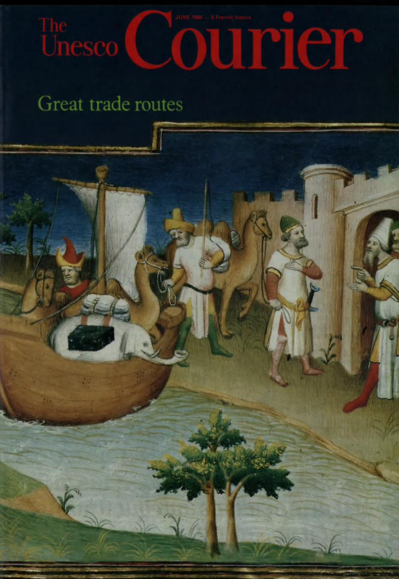
Unesco
JUNE
I
Great trade routes
/

A time to live...
24 Senegal
Dance and gesture
Dancers of Mudra-Africa, the African
Training and Research Centre for the Per¬
forming Arts, Dakar, Senegal, perform a
pas de deux. This interdisciplinary, inter-
cultural experimental centre was founded in
1977 at the instigation of the former Presi¬
dent of Senegal, Leopold Sedar Senghor,
and the French choreographer Maurice Bé-
jart (earlier, in 1970, Bejart had founded in
Brussels a school of dance which he called
"Mudra", a Sanskrit word meaning
"gesture"). For an initial period Mudra-
Africa received financial assistance from
Unesco's International Fund for the Pro¬
motion of Culture and the Calouste
Gulbenkian Foundation. Directed by Ger¬
maine Acogny, it has provided intensive
training for African dancers and cultural
organizers. The school plans to make its
permanent home in Senegal. A series of
ballets has been created and presented in
several capitals in Africa and Europe.
The
Unesco CourierA window open on the world
Editorial June 198437th year
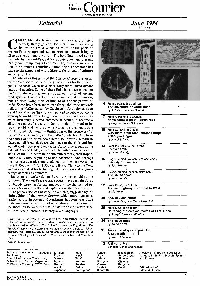
CARAVANS slowly wending their way across desert
wastes; stately galleons laden with spices sweeping
before the Trade Winds en route for the ports of
western Europe; supertankers the size of small towns bringing
oil to an energy-hungry world... The bold lines traced across
the globe by the world's great trade routes, past and present,
readily conjure up images like these. They also raise the ques¬
tion of the immense contribution that long-distance trade has
made to the shaping of world history, the spread of cultures
and ways of life.
The articles in this issue of the Unesco Courier are an at¬
tempt to rediscover some of the great arteries for the flow of
goods and ideas which have since early times linked distant
lands and peoples. Some of these links have been enduring:
modern highways that are a natural outgrowth of ancient
road systems that developed with commercial expansion;
modern cities owing their location to an ancient pattern of
trade. Some have been more transitory: the trade network
built in the Mediterranean by Carthage in Antiquity came to
a sudden end when the city was reduced to rubble by Rome
aspiring to world power. Bruges, on the other hand, was a city
which brilliantly survived commercial decline to become a
glittering centre of art and, today, a model of urbanism in¬
tegrating old and riew. Some, such as the overland route
which brought tin from the British Isles to the bronze crafts¬
men of Ancient Greece, and the paths by which amber from
the shores of the North Sea filtered southwards, remain in
places tantalizingly elusive, -a challenge to the skills and im¬
agination of modern archaeologists. As for others, such as the
old east African trade patterns which existed long before the
arrival of the Europeans in the fifteenth century, their impor¬
tance is only now beginning to be understood. And perhaps
the most classic trade route of all was also the most versatile:
the Silk Road which for 1,500 years linked China to the West
and was a conduit for technological innovation and religious
change as well as commerce.
But there is a darker side to the story which should not be
forgotten. The world's great trade routes have been the focus
for bloody struggles for supremacy, and the channels of in¬
famous forms of traffic and exploitation: the slave trade.
The preparation of this issue, on a theme, suggested by the
Urdu edition of the Unesco Courier, which more than most
reaches across the oceans and continents, has been largely due
to the magazine's own form of international exchange close
collaboration between the staff of its worldwide network of
editions now published in twenty-seven languages.
Cover: Illustration from a 15th-century French translation, now in the
Bibliothèque Nationale, Paris, of Marco Polo's own description of his
travels entitled // Milione ("The Million", known in English as "The
Travels of Marco Polo"). II Milione was dictated by Marco Polo to a fellow
prisoner, Rustichello da Pisa, during his three years of imprisonment by the
Genoese following their defeat of the Venetians at the battle of Curzola in
1298.
Photo* © Edimedia, Paris
From barter to big business
The adventure of world trade
by A.J. Barbosa Lima Sobrinho
7 From Alexandria to Gibraltar
North Africa's great Roman road
by Eugenia Equini Schneider
10 From Cornwall to Corinth
Was there a 'tin road' across Europe
2,500 years ago?
by Hanni Schwab
13 From the Baltic to the Levant
Forever amber
by Walter Raunig
.16 Bruges, a medieval centre of commerce
Fair city of Flanders
by Paul Morren
20 Cloves, nutmeg, pepper, cinnamon..
The life of spice
by Khoo Joo Ee
22 From Cathay to Antioch
A silken highway from East to West
by Ma Yong
25 Sea, silk and sutras
by Rinnie Tang and Pierre Colombel
26 From Kilwa to Zimbabwe
Retracing the caravan routes of East Africa
by Joseph Frederick Mbwiliza
30 The slave trade
by André Kedros
31 From square-rigger to supertanker
A world athirst for oil
by Vincent Labouret
2 A time to live...
Senegal: Dance and gesture
Published monthly in 27 languages
by Unesco,
The United Nations Educational,
Scientific and Cultural Organization
7, Place de Fontenoy, 75700 Paris.
English Italian Turkish Macedonian A selection in Braille is published
French Hindi Urdu Serbo-Croat quarterly in English, French, Spanish
Spanish Tamil Catalan Slovene and Korean
Russian Hebrew Malaysian Chinese
German Persian Korean Bulgarian
Arabic Dutch Swahili Greek Editor-in-chief:
Japanese Portuguese Croato-Serb Edouard Glissant
ISSN 0041-5278
N° 6 - 1984 - OPI 84- 1 - 411 A
FROM BiÄRTER TO BIG BUSINESS
The adventure of world trade
by A.J. Barbosa Lima Sobrinho
IT is difficult for anyone who has even
only a superficial idea of the complex
pattern of world trade today to con¬
ceive of its modest origins, which can be
traced back to Palaeolithic times, when
men ceased to get their food by hunting and
began to produce it themselves.
These small farmers produced a few com¬
modities for their sustenance and survival,
but there were many other things they lack¬
ed, and they realized at an early stage that
they could exchange what they had for
some of the things they needed. This led
them to produce surpluses with which they
could obtain the goods they lacked. This is
how barter originated.
Barter was initially practised between
neighbours, then at the level of villages and
ALEXANDRE BARBOSA LIMA SOBRINHO.
Brazilian politician, journalist and essayist, is a
member of the Brazilian Literary Academy and
president of the Brazilian Press Association.
He was governor of Pemambuco from 1948
to 1951 and has written many books and
articles on the political history of Brazil.
la:ger communities. The barter system had
to overcome many obstacles. It was, for in¬
stance, necessary to produce the articles
which were needed by the owners of other
goods.
Trade in the strict sense started in the
Mediterranean, in the valleys of the Nile,
the Jordan and Euphrates, along the coasts
of the Red Sea, the Dead Sea and the Gulf.
This extensive area in which Egypt, Arabia,
Palestine, Syria, Mesopotamia and Assyria
came into being in a sense constituted a
geopolitical and physical unit that was to in¬
fluence the destiny of its inhabitants.
Egypt played a leading role in this initial
stage of trade because of the wealth it deriv¬
ed from the fertilizing floods of the Nile.
She established regular relations with Asia.
Her caravans set out in search of the pro¬
ducts of Phoenicia, Syria and the Red Sea
area. The Bible tells us that the brothers of
Joseph transported the most precious ar¬
ticles to be found in their landbalsam and
honey, perfumes and myrrh, pistachios and
almonds. Egypt's imports included wood,
ivory, gold, wine and oil, and she exported
grain, textiles and manufactured articles,
especially arms. Trade took place overland
because the Egyptians were not great
sailors; it was still conducted on a barter
basis and sometimes consisted in the pay¬
ment of tribute by subject peoples.
Governments began to take an interest in
trade, encouraging and sometimes controll¬
ing it. Although money was still unknown,
barter operations between private traders
became easier and more frequent once they
had a fixed weight of metal gold or
silver as a common standard of reference.
Photo of the bazaar at Damascus (Syria) was
taken by the French photographer Félix
Bonfils (1825-1885). It belongs to a
remarkable collection of historical photos
on the Middle East in the possession of the
Semitic Museum of Harvard University. A
series ofposters on the history of the Middle
East, based on the photographic documen¬
tation of the Semitic Museum is currently
being published with the support of
Unesco's International Fund for the Promo¬
tion of Culture.
ykn A ¡Ail > rVL W- f / >rvï, ^> V*^"_*^
0B9^BBflËWi^&''-TVSJfa BEST* ft^^^ÉÉk^^^^B«^ Et
rrrf **"" -.**» * *'1^^*'
-- s -t. ta .* - ^ Ki^i-
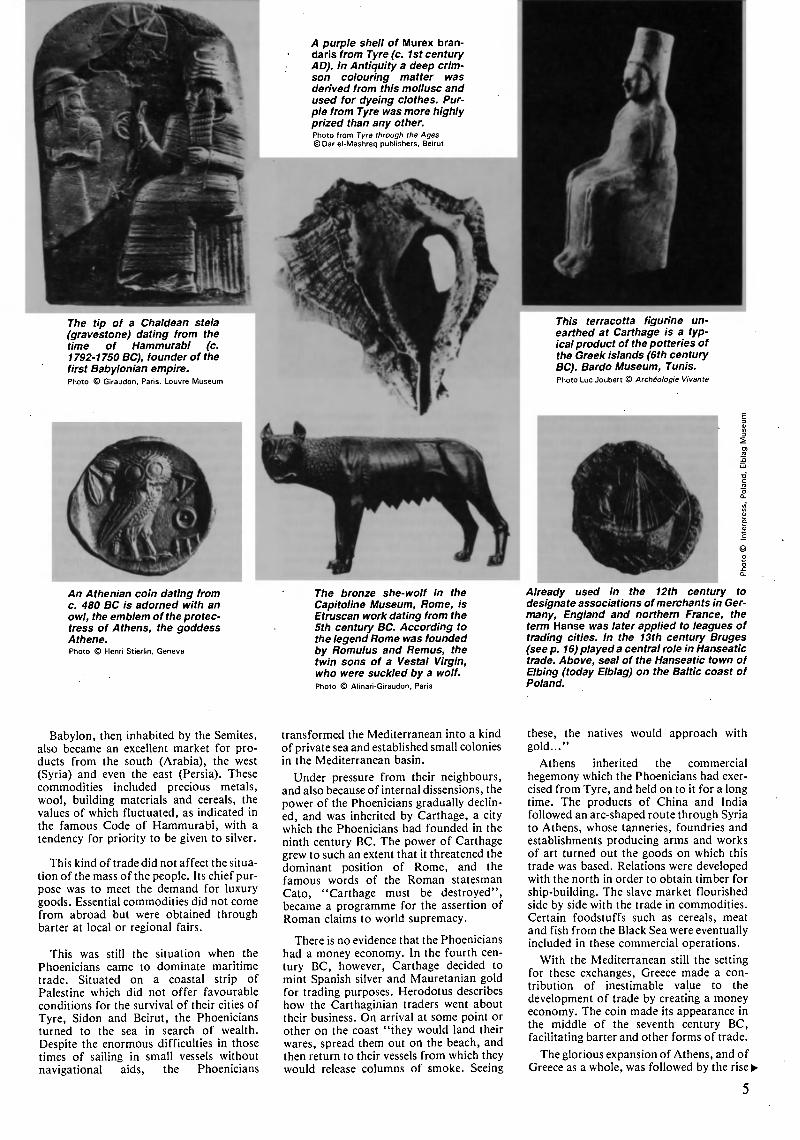
The tip of a Chaldean stela
(gravestone) dating from the
time of Hammurabi (c.
1792-1750 BC), founder of the
first Babylonian empire.
Photo © Giraudon, Paris. Louvre Museum
An Athenian coin dating from
c. 480 BC is adorned with an
owl, the emblem of the protec¬
tress of Athens, the goddess
Athene.
Photo © Henri Stierlin, Geneva
A purple shell of Murex bran-
daris from Tyre (c. 1st century
AD). In Antiquity a deep crim¬
son colouring matter was
derived from this mollusc and
used for dyeing clothes. Pur¬
ple from Tyre was more highly
prized than any other.
Photo from Tyre through the Ages
©Dar el-Mashreq publishers, Beirut
The bronze she-wolf in the
Capitoline Museum, Rome, is
Etruscan work dating from the
5th century BC. According to
the legend Rome was founded
by Romulus and Remus, the
twin sons of a Vestal Virgin,
who were suckled by a wolf.
Photo © Alinari-Giraudon, Paris
This terracotta figurine un¬
earthed at Carthage is a typ¬
ical product of the potteries of
the Greek islands (6th century
BC). Bardo Museum, Tunis.
Photo Luc Joubert © Archéologie Vivante
Already used in the 12th century to
designate associations ofmerchants in Ger¬
many, England and northern France, the
term Hanse ivas later applied to leagues of
trading cities. In the 13th century Bruges
(see p. 16) played a central role in Hanseatic
trade. Above, seal of the Hanseatic town of
Elbing (today Elblag) on the Baltic coast of
Poland.
Babylon, then inhabited by the Semites,
also became an excellent market for pro¬
ducts from the south (Arabia), the west
(Syria) and even the east (Persia). These
commodities included precious metals,
wool, building materials and cereals, the
values of which fluctuated, as indicated in
the famous Code of Hammurabi, with a
tendency for priority to be given to silver.
This kind of trade did not affect the situa¬
tion of the mass of the people. Its chief pur¬
pose was to meet the demand for luxury
goods. Essential commodities did not come
from abroad but were obtained through
barter at local or regional fairs.
This was still the situation when the
Phoenicians came to dominate maritime
trade. Situated on a coastal strip of
Palestine which did not offer favourable
conditions for the survival of their cities of
Tyre, Sidon and Beirut, the Phoenicians
turned to the sea in search of wealth.
Despite the enormous difficulties in those
times of sailing in small vessels without
navigational aids, the Phoenicians
transformed the Mediterranean into a kind
of private sea and established small colonies
in the Mediterranean basin.
Under pressure from their neighbours,
and also because of internal dissensions, the
power of the Phoenicians gradually declin¬
ed, and was inherited by Carthage, a city
which the Phoenicians had founded in the
ninth century BC. The power of Carthage
grew to such an extent that it threatened the
dominant position of Rome, and the
famous words of the Roman statesman
Cato, "Carthage must be destroyed",
became a programme for the assertion of
Roman claims to world supremacy.
There is no evidence that the Phoenicians
had a money economy. In the fourth cen¬
tury BC, however, Carthage decided to
mint Spanish silver and Mauretanian gold
for trading purposes. Herodotus describes
how the Carthaginian traders went about
their business. On arrival at some point or
other on the coast "they would land their
wares, spread them out on the beach, and
then return to their vessels from which they
would release columns of smoke. Seeing
these, the natives would approach with
gold..."
Athens inherited the commercial
hegemony which the Phoenicians had exer¬
cised from Tyre, and held on to it for a long
time. The products of China and India
followed an arc-shaped route through Syria
to Athens, whose tanneries, foundries and
establishments producing arms and works
of art turned out the goods on which this
trade was based. Relations were developed
with the north in order to obtain timber for
ship-building. The slave market flourished
side by side with the trade in commodities.
Certain foodstuffs such as cereals, meat
and fish from the Black Sea were eventually
included in these commercial operations.
With the Mediterranean still the setting
for these exchanges, Greece made a con¬
tribution of inestimable value to the
development of trade by creating a money
economy. The coin made its appearance in
the middle of the seventh century BC,
facilitating barter and other forms of trade.
The glorious expansion of Athens, and of
Greece as a whole, was followed by the rise^
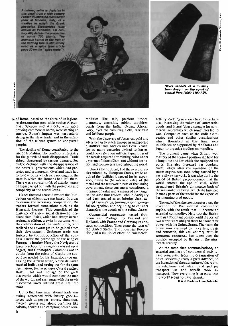
A nutmeg seller is depicted in
this detail from a 15th-century
French illuminated manuscript
(now at Modena, Italy) of a
treatise in which the Greek
physician Dioscorides (also
known as Pedanius, 1st cen¬
tury AD) details the properties
of some 700 plants. The
aromatic kernel of the fruit of
the nutmeg tree is still widely
used as a spice (see article
page 20 on the ' 'spice route ' ').
©
Silver sandals of a mummy
from Ancón, on the coast of
central Peru (1000-1400 AD).
^ of Rome, based on the force of its legions.
At the same time great cities such as Alexan¬
dria, Seleucia and Antioch, with more
pressing commercial needs, were starting to
emerge. Rome's impact was particularly
strong in the slave trade, and in the exten¬
sion of the tribute system to conquered
peoples.
The decline of Rome contributed to the
rise of feudalism. The conditions necessary
for the growth of trade disappeared. Trade
ebbed, threatened by serious dangers. Sea
traffic declined with the disappearance of
the powerful governments which had pro¬
tected and promoted it. Overland trade had
to follow routes which were no longer in the
state in which the Romans had left them.
There was a constant risk of attacks, many
of them carried out with the protection and
complicity of the feudal lords.
Hence the need arose to restore the foun¬
dations on which trade was based. In order
to ensure the necessary co-operation, the
traders formed associations such as the
Hanseatic League. This consolidated the
existence of a new social class the mer¬
chant class. Fairs, which had always been a
regional tradition, grew in importance, with
the collaboration of the feudal lords, who
realized the advantages to be gained from
their development. Seaborne trade was
fostered by the introduction of the com¬
pass. Under the patronage of the King of
Portugal's brother Henry the Navigator, a
training school for navigators was set up at
Sagres, and Christopher Columbus was to
obtain from the rulers of Castile the sup¬
port he needed for his hazardous voyage.
Taking the African route, Vasco de Gama
reached India, and setting out for the same
destination, Pedro Alvarez Cabrai reached
Brazil. This was the age of the great
discoveries which would complete the map
of the world; and exchanges with the newly
discovered lands infused fresh life into
trade.
Up to that time international trade was
. mainly concerned with luxury goods
spices such as pepper, cloves, cinnamon,
nutmeg, ginger and aloes; perfumes like
balsam, benzoin and camphor; scarce com-
6
modities like salt, precious stones,
diamonds, emeralds, rubies, sapphires;
pearls from the Indian Ocean, African
ivory, dyes for colouring cloth, rare silks
and brilliant purple.
With the discovery of America, gold and
silver began to reach Europe in unexpected
quantities from Mexico and Peru. Trade,
for so many centuries limited to barter,
could now rely upon sufficient quantities of
the metals required for minting coins under
a system of bimetallism, not without hesita¬
tion and controversy throughout the world.
Thanks to the ducat, and the new curren¬
cies minted by European States, trade ac¬
quired the facilities it needed for its expan¬
sion; owing to the intrinsic value of the
metal and the trustworthiness of the issuing
government, these currencies constituted a
measure of value and a means of exchange.
At the same time traders, who in Antiquity
had been treated as an inferior class, ac¬
quired a new status, forming a solid, power¬
ful bourgeoisie, and beginning to consider
themselves the equals of the ruling classes.
Commercial supremacy passed from
Spain and Portugal to England and
Holland, with France and Germany in con¬
stant competition. Then came the turn of
the United States. The Industrial Revolu¬
tion Jiad a multiplier effect on commercial
activity, creating new varieties of merchan¬
dise, increasing the volume of commercial
goods, and intensifying a struggle for com¬
mercial supremacy which sometimes led to
war. Companies such as the India Com¬
panies and other similar organizations
which flourished at this time, were
established or supported by the States and
began to organize trading monopolies.
The moment came when Britain won
mastery of the seas a position she held for
a long time and for which she equipped her
ports. She also increased her overland
trade, which after the invention of the
steam engine, was soon being carried by a
vast railway network. It was also during the
period of British preponderance that the
world entered the age of coal, which
strengthened Britain's dominance both of
the seas and of railways, which she financed
in many parts of the world for the export of
her manufactured goods.
The end of the nineteenth century saw the
invention of the internal combustion
engine, with the result that oil became an
essential commodity. Here too the British
were in a dominant position until the cost of
two world wars obliged them to share their
power with the United States. Thanks to the
power now exercised by its cartels, trusts
and consortia, this vast country, with its
enormous resources, has taken over the
position occupied by Britain in the nine¬
teenth century.
At the same time communications, an
essential auxiliary of commercial activity,
have progressed from the organization of
postal services (already a great advance) to
the invention of the submarine cable, radio,
the telephone and telex. Land and sea
transport use and benefit from air
transport. Now everything is so close that
the world seems to have shrunk.
A.J. Barbosa Lima Sobrinho
FROM A LEXAN D R I A TO G I B R A L TAR
NORTH AFRICA'S
GREAT ROMAN ROAD
by Eugenia Equini Schneider
®
THE existence in Roman times of a
great coastal highway linking all the
African provinces facing the Medi¬
terranean, from Alexandria in Egypt tö the
Pillars of Hercules, is attested, not so much
by archaeological remains, as by two
famous documents dealing with ancient
highways: the Antonine Itinerary and the
Peutinger Table.
Both these documents date from the Late
Roman Empire, but they appear to reflect
historical facts of an earlier period. They
mention two East-West routes which large¬
ly followed different itineraries. The An¬
tonine Itinerary speaks of a route which
kept close to the coast most of the time,
although it swung inland at a number of
places which were recognized as being mar¬
shy or inaccessible. The itinerary mentioned
in the Peutinger Table generally runs
parallel to the coast but further inland than
the other. Apart from these documents,
milestone inscriptions found so far are a
valuable source of information about the
construction of the individual sections of
the main highway.
EUGENIA EQUINI SCHNEIDER, of Italy, is a
lecturer in the archaeology of the Roman Pro¬
vinces at the University of Rome.
There is no doubt that the great coastal
highway linking Alexandria and Tingis
(Tangiers) was originally mapped out in
such a way as to take account of the
topographical relief, and met certain
military and commercial needs as well as en¬
couraging the growth of urbanization. It
was still incomplete in the time of Tiberius,
but was very extensive at the end of the first
century AD. It probably acquired its final
form under the Emperors Trajan and
Hadrian.
In Roman times, several sections of the
highway followed routes previously taken
by the Phoenicians and the Greeks,
stretches of which were joined up or cor¬
rected as the Roman dominion was extend¬
ed or confirmed in each region. Indeed,
then as now, the northern coast of Africa
was marked by two places of major impor¬
tance: in the east the Nile delta on which the
great port of Alexandria was built in the
fourth century BC, and in the west the pro¬
montory of Bizerta, on which the Phoeni¬
cians established Carthage, which
dominated all trade in the western Mediter¬
ranean until its destruction by the Romans
in 146 BC.
In ancient times trade between Alexan¬
dria and Carthage, through Cyrenaica and
the region of the Carthaginian trading sta¬
tions (Sabratha, Oea-Tripolis, Leptis) must
have been quite considerable. The existence
of a sea-current flowing from east to west
which, according to some experts,
hampered the movement of ships coming
from Egypt, must have encouraged the
overland transport of goods, at least from
Alexandria to Cyrene.
Sources of information about the pre-
Roman road network are, however, very
fragmentary. The only trustworthy docu¬
ment which has come down to us is the so-
called Periplus of Scylax, dating from the
fourth century BC. It suggests that there
was at that time either a coastal maritime
itinerary divided into several short stages
from Egypt as far as Hesperides (Ben¬
ghazi), or a guide to longer overland routes
along the Cyrenaican and Syrtic coasts. The
latter were taken in 308-305 BC by Ophelia
and his Greek army when, as the ally of
Agathocles of Syracuse, he mounted an of¬
fensive against Carthage from Cyrene. But
the journey cannot have been an easy one,
because Diodorus of Sicily reports that
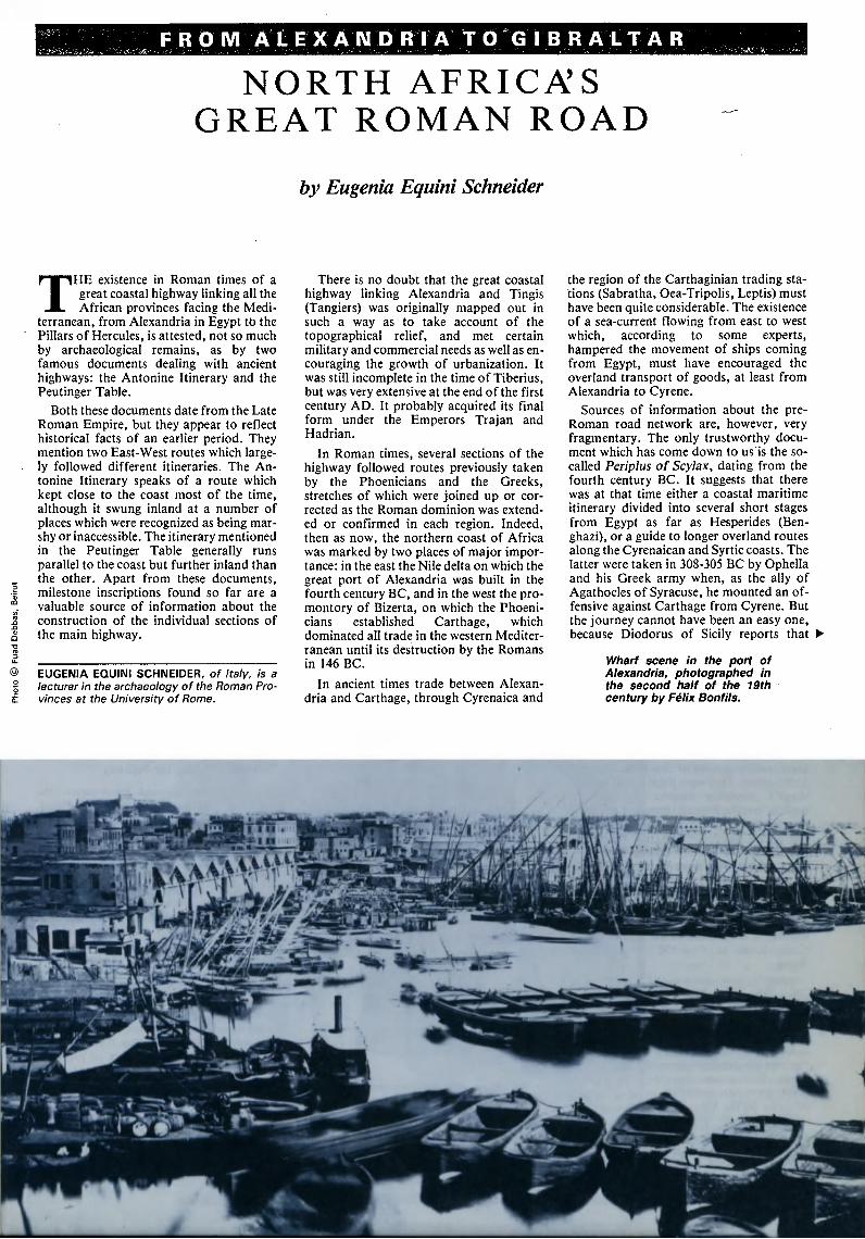
Wharf scene in the port of
Alexandria, photographed in
the second half of the 19th
century by Félix Bonfils.
"Ophelia's army advanced with great dif¬
ficulty in territory without water and in¬
fested by wild animals", and that a large
part of the army was decimated by the
privations suffered when rounding Syrtis
Major (the Gulf of Sidra) on the way to
Leptis. The Greek geographer Strabo tells
us that between 48 and 47 BC Cato of Utica
also crossed the Syrtis Major region in thir¬
ty days with 10,000 men, probably follow¬
ing a difficult coastal route.
The rebuilding of Carthage, undertaken
on the orders of Julius Caesar and com¬
pleted under Augustus, and of its port, to
which the products of North Africa soon
began to flow, especially wheat for the im¬
perial capital (one and half million
bushels enough to feed 600,000 people for
a year were delivered annually to Rome)
stimulated the revival of trade. It also con¬
tributed to the development of the great
coastal highway which ran across the Lib¬
yan desert from present-day Tunisia to
Sabratha, the most westerly city of
Tripolitania. The principal geographical
feature of the region is the jebel, a rocky
plateau which rises to 700 metres, just
behind the coast. It was in this region where
a Mediterranean climate and seasonal rains
contribute to the fertility of the soil, that the
great trading centres of Sabratha, Oea and
Leptis arose. They were focal points of Car¬
thage's maritime empire and natural
outlets, even in Roman times, for the com¬
mercial traffic which was conducted from
the Sudan and central Africa across the
Sahara to the Mediterranean. Trade in
ivory and in wild animals for the Roman
circus must have flourished as is indicated
by the marble statue of an elephant found
at Leptis Magna, and the figure of an
elephant (the emblem of the Sabratha mer¬
chants) in the mosaic in the Square of the
Corporations at Ostia, the port of ancient
Rome.
Forty miles from Sabratha, Oea-Tripolis
possessed a fine natural harbour, abundant
supplies of fresh water, and olive-groves in
the hinterland. The amount of oil produced
was such that Julius Caesar could demand
a tribute of a million measures to punish
the city for having supported the enemy.
Leptis Magna was the third city of Tri¬
polis, and undoubtedly the most important
of those on the Mediterranean littoral bet¬
ween Carthage and Alexandria. Leptis
possessed a small, natural river-port, form¬
ed by the estuary of the Lebda wadi and
sheltered from the Etesian winds by a pro-
8
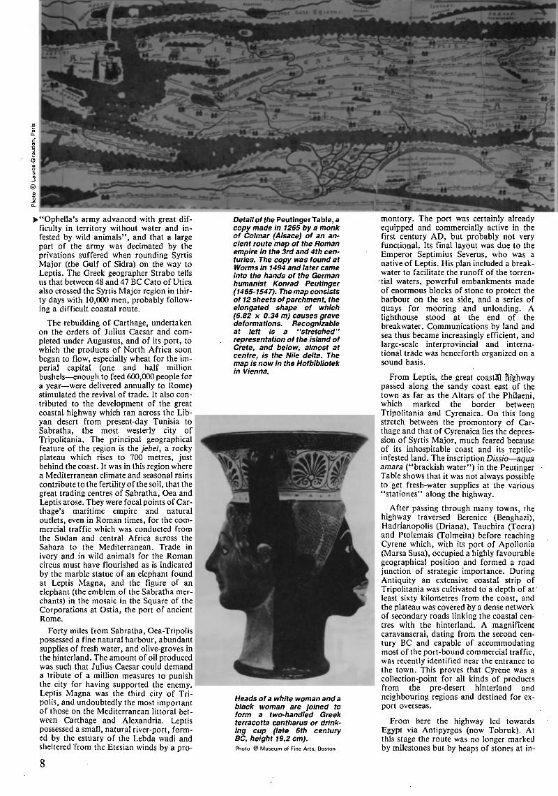
Detail of the Peutinger Table, a
copy made in 1265 by a monk
of Colmar (Alsace) of an an¬
cient route map of the Roman
empire in the 3rd and 4th cen¬
turies. The copy was found at
Worms in 1494 and later came
into the hands of the German
humanist Konrad Peutinger
(1465-1547). The map consists
of 12 sheets ofparchment, the
elongated shape of which
(6.82 x 0.34 m) causes grave
deformations. Recognizable
at left is a "stretched"
representation of the island of
Crete, and below, almost at
centre, is the Nile delta. The
map is now in the Hofbibliotek
in Vienna.
Heads of a white woman anda
black woman are joined to
form a two-handled Greek
terracotta cantharus or drink¬
ing cup (late 6th century
BC, height 19.2 cm).
Photo © Museum of Fine Arts, Boston
montory. The port was certainly already
equipped and commercially active in the
first century AD, but probably not very
functional. Its final layout was due to the
Emperor Septimius Severus, who was a
native of Leptis. His plan included a break¬
water to facilitate the runoff of the torren¬
cial waters, powerful embankments made
of enormous blocks of stone to protect the
harbour on the sea side, and a series of
quays for mooring and unloading. A
lighthouse stood at the end of the
breakwater. Communications by land and
sea thus became increasingly efficient, and
large-scale interprovincial and interna¬
tional trade was henceforth organized on a
sound basis.
From Leptis, the great coastal highway
passed along the sandy coast east of the
town as far as the Altars of the Philaeni,
which marked the border between
Tripolitania and Cyrenaica. On this long
stretch between the promontory of Car¬
thage and that of Cyrenaica lies the depres¬
sion of Syrtis Major, much feared because
of its inhospitable coast and its reptile-
infested land. The inscription Dissio aqua
amara ("brackish water") in the Peutinger
Table shows that it was not always possible
to get fresh-water supplies at the various
"stationes" along the highway.
After passing through many towns, the
highway traversed Berenice (Benghazi),
Hadrianopolis (Driana), Tauchira (Tocra)
and Ptolemais (Tolmeita) before reaching
Cyrene which, with its port of Apollonia
(Marsa Susa), occupied a highly favourable
geographical position and formed a road
junction of strategic importance. During
Antiquity an extensive coastal strip of
Tripolitania was cultivated to a depth of at
least sixty kilometres from the coast, and
the plateau was covered by a dense network
of secondary roads linking the coastal cen¬
tres with the hinterland. A magnificent
caravanserai, dating from the second cen¬
tury BC and capable of accommodating
most of the port-bound commercial traffic,
was recently identified near the entrance to
the town. This proves that Cyrene was a
collection-point for all kinds of products
from the pre-desert hinterland and
neighbouring regions and destined for ex¬
port overseas.
From here the highway led towards
Egypt via Antipyrgos (now Tobruk). At
this stage the route was no longer marked
by milestones but by heaps of stones at in-
tervals of twenty miles (a day's journey)
where the stationes and fresh-water wells
were located. In those days the traveller
would first pass through Taposiris, on the
great bay of Sinus Pilinthinus (Marmarica),
the first Egyptian coastal town of any im¬
portance; then after a further day's journey
he would reach the outskirts of Alexandria.
"There is an island called Pharos in the sea
off the coast of Egypt. Here there is a bay
with good anchorage from which ships
head out to sea after taking on fresh
water". This is how Homer, in the Odyssey
describes the promontory on which the
great lighthouse of Alexandria was built
under Ptolemy II in the third century BC
"in honour of Jupiter the Saviour, for his
sailors". The great port of Alexandria, the
finest and best equipped of the ancient
world, rose on the west of the Nile delta. In
Roman times the city, exceptionally well
situated between the Mediterranean and the
Red Sea on the route to India, was a huge
emporium not only for foodstuffs (Roman
Egypt was the empire's granary) but also
for glass, linen, textiles of all qualities,
papyri, precious woods, ivory and precious
metals.
In 42 AD the Emperor Claudius officially
annexed Mauretania, a vast region of
mountains and desert comprising present-
day Morocco and the whole of coastal
Algeria. By restoring and widening a Car¬
thaginian trail and gradually extending it
westwards as far as Tingis and southwards
to Rabat, the Romans created a continuous
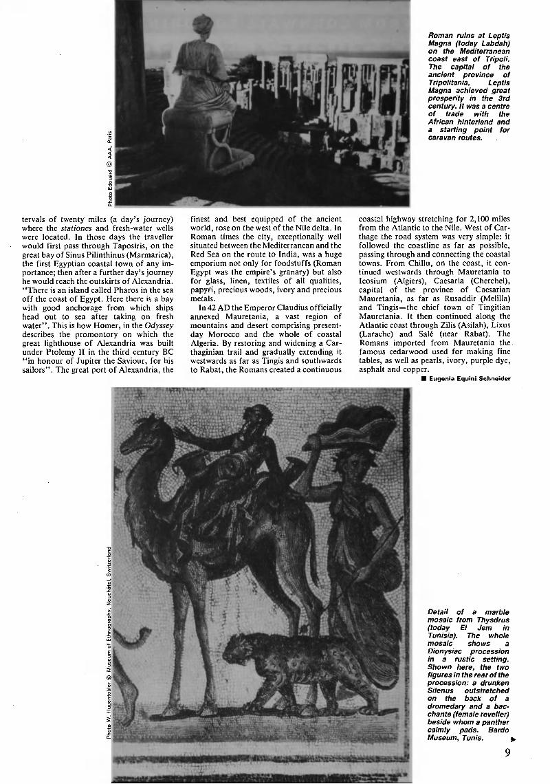
Roman ruins at Leptis
Magna (today Labdah)
on the Mediterranean
coast east of Tripoli.
The capital of the
ancient province of
Tripolitania, Leptis
Magna achieved great
prosperity in the 3rd
century. It was a centre
of trade with the
African hinterland and
a starting point for
caravan routes.
coastal highway stretching for 2,100 miles
from the Atlantic to the Nile. West of Car¬
thage the road system was very simple: it
followed the coastline as far as possible,
passing through and connecting the coastal
towns. From Chillu, on the coast, it con¬
tinued westwards through Mauretania to
Icosium (Algiers), Caesaria (Cherchel),
capital of the province of Caesarian
Mauretania, as far as Rusaddir (Melilla)
and Tingis the chief town of Tingitian
Mauretania. It then continued along the
Atlantic coast through Zilis (Asilah), Lixus
(Larache) and Salé (near Rabat). The
Romans imported from Mauretania the
famous cedarwood used for making fine
tables, as well as pearls, ivory, purple dye,
asphalt and copper.
Eugenia Equini Schneider
Detail of a marble
mosaic from Thysdrus
(today El Jem in
Tunisia). The whole
mosaic shows a
Dionysiac procession
in a rustic setting.
Shown here, the two
figures in the rear of the
procession: a drunken
Silenus outstretched
on the back of a
dromedary and a bac¬
chante (female reveller)
beside whom a panther
calmly pads. Bardo
Museum, Tunis. ^
»grew
F^fîfTfl^^
WAS THERE A 'TIN ROAD'
ACROSS EUROPE 2,500 YEARS AGO?
by Hanni Schwab
DURING the sixth century BC the
Greeks used tin from Cornwall for
making bronzes. This precious
metal was transported by boat along the
Atlantic coast, through the Straits of
Gibraltar and across the Mediterranean to
Greece. Around the middle of the sixth cen¬
tury Carthage became an important sea
power, and in 540 concluded a treaty with
the Etruscans against the Greeks who were
then the dominant Mediterranean power.
In 535 the Greeks were defeated at the
HANNI SCHWAB, of Switzerland, is a pro¬
fessor at the University of Fribourg and a
member of the Swiss National Archaeology
Council. She is an expert on the Swiss
neolithic period, a subject on which she has
written numerous articles and studies.
Battle of Alalia and lost control of the
Mediterranean. They could no longer even
reach their colony of Massalia (Marseilles)
and were compelled to find a new overland
route across the Alps to transport their tin
from England. As far as possible they used
inland waterways, rivers and lakes, and the
points where their wagons were trans¬
shipped were the most critical stages in the
journey.
It may seem an exaggeration to describe
as a "tin route" a line on the map of Europe
of which only a few scattered points can be
traced. But these points, which represent
the sites of discoveries in France, Mont
Lassois and Vix, Bragny-sur-Saône, the
fortified camp at Salins-les-Bains;
Châtillon-sur-Glâne in Switzerlandare so
important and have so many features in
common that they can be related to one
another. Archaeological finds dating from
the late sixth and the early fifth century BC
which have been unearthed along the route
include objects imported from Greece and
Phocaea, as well as from the region of
Marseilles. All these sites, which are located
between the upper reaches of the Seine and
A major centre in the trade between nor¬
thern and southern Europe some 2,500
years ago, Heuneburg is today a deserted
flat-topped hill overlooking the stripling
Danube (bottom ofphoto) southwest of Ulm
in the Federal Republic of Germany. Right,
reconstituted amphora and amphora
fragments unearthed at Heuneburg were
manufactured in the Marseilles region.
i-^4
^*í*^*^^*
PIN "i
t*fc(-#-
England
Cornwall
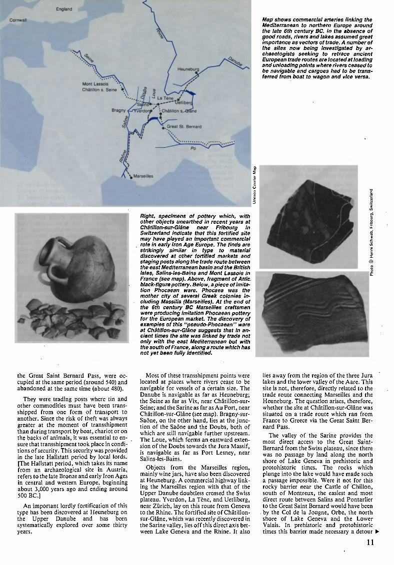
Right, specimens of pottery which, with
other objects unearthed in recent years at
Châtillon-sur-Glâne near Fribourg in
Switzerland indicate that this fortified site
may have played an important commercial
role in early Iron Age Europe. The finds are
strikingly similar in type to material
discovered at other fortified markets and
staging posts along the trade route between
the east Mediterranean basin and the British
Isles, Salins-les-Bains and Mont Lassois in
France (see map). Above, fragment of Attic,
black-figure pottery. Below, a piece of imita¬
tion Phocaean ware. Phocaea was the
mother city of several Greek colonies in¬
cluding Massilia (Marseilles). At the end of
the 6th century BC Marseilles craftsmen
were producing imitation Phocaean pottery
for the European market. The discovery of
examples of this "pseudo-Phocaean" ware
at Châtillon-sur-Glâne suggests that in an¬
cient times the site was linked by trade not
only with the east Mediterranean but with
the south ofFrance, along a route which has
not yet been fully identified.
Map shows commercial arteries linking the
Mediterranean to northern Europe around
the late 6th century BC. In the absence of
good roads, rivers and lakes assumed great
importance as vectors of trade. A number of
the sites now being investigated by ar¬
chaeologists seeking to retrace ancient
European trade routes are located at loading
and unloading points where rivers ceased to
be navigable and cargoes had to be trans¬
ferred from boat to wagon and vice versa.
the Great Saint Bernard Pass, were oc¬
cupied at the same period (around 540) and
abandoned at the same time (about 480).
They were trading posts where tin and
other commodities must have been trans¬
shipped from one form of transport to
another. Since the risk of theft was always
greater at the moment of transshipment
than during transport by boat, chariot or on
the backs of animals, it was essential to en¬
sure that transshipment took place in condi¬
tions of security. This security was provided
in the late Hallstatt period by local lords.
[The Hallstatt period, which takes its name
from an archaeological site in Austria,
refers to the late Bronze and early Iron Ages
in central and western Europe, beginning
about 3,000 years ago and ending around
500 BC]
An important lordly fortification of this
type has been discovered at Heuneburg on
the Upper Danube and has been
systematically explored over some thirty
years.
Most of these transshipment points were
located at places where rivers cease to be
navigable for vessels of a certain size. The
Danube is navigable as far as Heuneburg;
the Seine as far as Vix, near Châtillon-sur-
Seine; and the Sarine as far as Au Port, near
Châtillon-sur-Glâne (see map). Bragny-sur-
Saône, on the other hand, lies at the junc¬
tion of the Saône and the Doubs, both of
which are still navigable further upstream.
The Loue, which forms an eastward exten¬
sion of the Doubs towards the Jura Massif,
is navigable as far as Port Lesney, near
Salins-les-Bains.
Objects from the Marseilles region,
mainly wine jars, have also been discovered
at Heuneburg. A commercial highway link¬
ing the Marseilles region with that of the
Upper Danube doubtless crossed the Swiss
plateau. Yverdon, La Tène, and Uetliberg,
near Zürich, lay on this route from Geneva
to the Rhine. The fortified site of Châtillon-
sur-Glâne, which was recently discovered in
the Sarine valley, lies off this direct axis bet¬
ween Lake Geneva and the Rhine. It also
lies away from the region of the three Jura
lakes and the lower valley of the Aare. This
site is not, therefore, directly related to the
trade route connecting Marseilles and the
Heuneburg. The question arises, therefore,
whether the site at Châtillon-sur-Glâne was
situated on a trade route which ran from
France to Greece via the Great Saint Ber¬
nard Pass.
The valley of the Sarine provides the
most direct access to the Great Saint-
Bernard from the Swiss plateau, since there
was no passage by land along the north
shore of Lake Geneva in prehistoric and
protohistoric times. The rocks which
plunge into the lake would have made such
a passage impossible. Were it not for this
rocky barrier near the Castle of Chillón,
south of Montreux, the easiest and most
direct route between Salins and Pontarlier
to the Great Saint Bernard would have been
by the Col de la Jougne, Orbe, the north
shore of Lake Geneva and the Lower
Valais. In prehistoric and protohistoric
times this barrier made necessary a detour I
11
the Val de Travers, the region of
the three lakes on the western Swiss plateau,
the valley of the Sarine and the Col des
Mosses to the Valais. Hence the location of
Châtillon-sur-Glâne away from the impor¬
tant routes of more recent origin.
The site was discovered in 1974 by an
amateur archaeologist. The presence of At¬
tic potsherds decorated with black figures,
and of bronze fibulae brooches or
clasps from the late Hallstatt period,
enable us to date the site, which was pro¬
tected by an earthen rampart and moat at
the end of the First Iron Age. A series of
very limited exploratory excavations con¬
firmed the hypothesis that it was a late
Hallstatt princely fortification. This con¬
clusion is strengthened by the surrounding
ring of large burial mounds, the biggest of
which, in the forest of Moncor, measures 85
metres in diameter and is 10 metres high.
The archaeological material unearthed at
Châtillon-sur-Glâne includes a large
number of imported articles such as
fragments of Massalian, pseudo-Phocaean
and pseudo-Ionian wine-jars. There are
also some forty fragments of Attic pottery
decorated with black figures, which was
manufactured in Greece, as well as
fragments of Etruscan vases and vessels
from the Este region of northern Italy. A
large quantity of local wheel-turned pottery
has also been found, as well as iron and
bronze objects which testify to the presence
of craftsmen's workshops inside the fort¬
ifications. Hallstattian sites, mainly burial
mounds, are very frequent on both sides of
the Sarine, and also in the upper valley of
the river. There is a fortified site on the hill
of the Bois d'Everdes, northeast of Bulle, at
the base of which rises a thirteen-metre-
high mound which, like the fortification,
has not yet been excavated. Further up the
valley of the Sarine, at Grandvillars, several
burial mounds from the Hallstatt period
were destroyed in the last century.
The fortified site on Mont Lassois has
been partially examined during several ex¬
ploratory excavations. Much interesting
material has beerl discovered there and been
preserved, some of it in the museum at
Châtillon-sur-Seine. Of particular impor¬
tance are the Attic potsherds with black
figures imported from Greece, and many
fragments of Massalian amphorae.
The archaeologist who explored the site,
René Joffroy, made a surprising discovery
in 1952 when he excavated the princely
tomb of Vix at the foot of Mont Lassois.
This, the richest known tomb from the
12
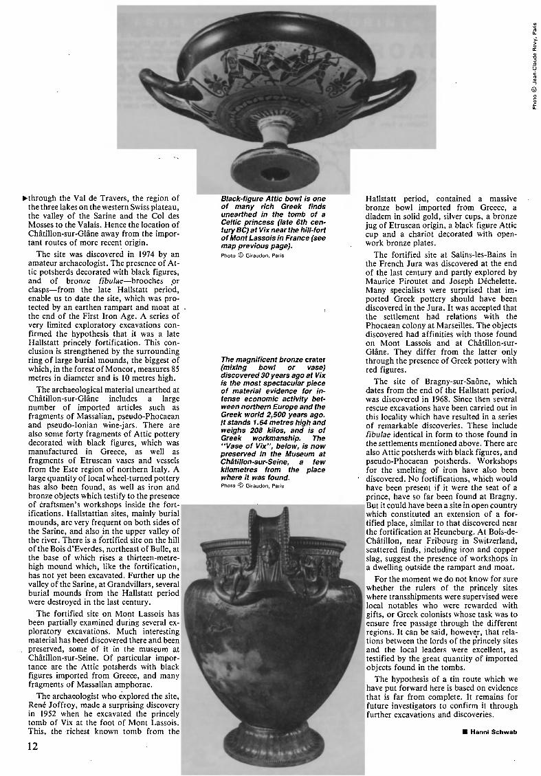
Black-figure Attic bowl is one
of many rich Greek finds
unearthed in the tomb of a
Celtic princess (late 6th cen¬
tury BC) at Vix near the hill-fort
of Mont Lassois in France (see
map previous page).
Photo © Giraudon, Paris
The magnificent bronze crater
(mixing bowl or vase)
discovered 30 years ago at Vix
is the most spectacular piece
of material evidence for in¬
tense economic activity bet¬
ween northern Europe and the
Greek world 2,500 years ago.
It stands 1.64 metres high and
weighs 208 kilos, and is of
Greek workmanship. The
"Vase of Vix", below, is now
preserved in the Museum at
Châtillon-sur-Seine, a few
kilometres from the place
where it was found.
Photo © Giraudon, Paris
Hallstatt period, contained a massive
bronze bowl imported from Greece, a
diadem in solid gold, silver cups, a bronze
jug of Etruscan origin, a black figure Attic
cup and a chariot decorated with open¬
work bronze plates.
The fortified site at Salins-les-Bains in
the French Jura was discovered at the end
of the last century and partly explored by
Maurice Piroutet and Joseph Déchelette.
Many specialists were surprised that im¬
ported Greek pottery should have been
discovered in the Jura. It was accepted that
the settlement had relations with the
Phocaean colony at Marseilles. The objects
discovered had affinities with those found
on Mont Lassois and at Châtillon-sur-
Glâne. They differ from the latter only
through the presence of Greek pottery with
red figures.
The site of Bragny-sur-Saône, which
dates from the end of the Hallstatt period,
was discovered in 1968. Since then several
rescue excavations have been carried out in
this locality which have resulted in a series
of remarkable discoveries. These include
fibulae identical in form to those found in
the settlements mentioned above. There are
also Attic potsherds with black figures, and
pseudo-Phocaean potsherds. Workshops
for the smelting of iron have also been
discovered. No fortifications, which would
have been present if it were the seat of a
prince, have so far been found at Bragny.
But it could have been a site in open country
which constituted an extension of a for¬
tified place, similar to that discovered near
the fortification at Heuneburg. At Bois-de-
Châtillon, near Fribourg in Switzerland,
scattered finds, including iron and copper
slag, suggest the presence of workshops in
a dwelling outside the rampart and moat.
For the moment we do not know for sure
whether the rulers of the princely sites
where transshipments were supervised were
local notables who were rewarded with
gifts, or Greek colonists whose task was to
ensure free passage through the different
regions. It can be said, however, that rela¬
tions between the lords of the princely sites
and the local leaders were excellent, as
testified by the great quantity of imported
objects found in the tombs.
The hypothesis of a tin route which we
have put forward here is based on evidence
that is far from complete. It remains for
future investigators to confirm it through
further excavations and discoveries.
Hanni Schwab

Lumps of amber (translucent
fossil resin) often contain in¬
sects trapped when the resins
flowed from the trees millions
of years ago.
TFH O M T H E B A L T I C T Ö T H Et EVA NT
Forever amber
by Walter Raunig
LONG before regular long-distance
travel was possible in central and
northern Europe, close links existed
in the Near East, North Africa, India and
China between centres and areas of high
culture. These links and contacts were
mainly if not exclusively made possible by
the spirit of enterprise and daring of in¬
dependent merchants, and in spite of
numerous military conflicts were never
completely or permanently broken off.
They led to exchanges of goods and ideas
which in turn helped to stimulate and
develop cultural exchanges, indeed to a
large degree made such exchanges possible.
WALTER RAUNIG, Austrian ethnologist, is
director of the Staatliches Museum für
Volkerkunde, Munich. He is the author of a
number of books and articles on the cultural
history of the Near East, with particular em¬
phasis on ancient trade patterns.
From the middle of the third millennium
onwards the use of metals (copper, bronze,
iron) was accompanied by an intensifica¬
tion and extension of this trade, which
played a decisive role in the cultural history
of mankind.
In Europe, around 1800 BC, with the
transition from the Neolithic (in the later
stage of which copper was already being
used) to the Bronze Age there was also a
perceptible growth in trade. The increasing
use of wheeled vehicles from the middle of
the third millennium onwards played an im¬
portant role in this phenomenon.
Like salt, the highly prized ores used for
producing bronze and, later, iron were
found, mined and worked only in certain
places. Copper, bronze and iron were far
more convenient to use than stone, and a
demand soon arose for them and for ob¬
jects made from them for domestic use,
hunting, war and adornment. The inten¬
sification of trade in Europe also led to a
wider and more rapid distribution of other
commodities. Some of them were
transported and marketed along certain
routes and this led to the growth of trade-
routes such as the "tin road" (see page 10)
and the "salt road". One of these com¬
modities was the petrified wood resin
known as amber, which was greatly prized
in ancient times and still is to some extent
today.
Amber is formed when liquid resin is
buried under a layer of sand or mud, and
achieves a stable state. Deposits of amber
have been found in various parts of Europe,
Asia and America, but in western Europe
the word amber was long applied only to the
fossil resin found in the Baltic and North
Sea regions. Similar fossil resins from twen¬
ty million to 1 20 million years old , have also
been discovered elsewhere in the
Lebanon, -Siberia, Burma, Sidily and the
Dominican Republic. It mainly occurs in
smallish lumps and pieces; it can be crystal
clear or cloudy opaque; and because it often
contains animal or vegetable matter, drops
13
of water or air bubbles, it is of great interest
to zoologists and palaeontologists. Its col¬
our ranges from light yellow to dark brown;
but it may be reddish or even blue.
The use of amber can be traced back to
early historical times. In Europe it has been
used for at least 10,000 years in the
manufacture of ornaments, implements
and utensils, works of art, for medicinal
purposes (amulets) and as a perfume (when
burnt). Modern compressed amber, pro¬
duced from very small or waste pieces, is
used as gem material or for technical pur¬
poses as an insulator. For thousands of
years, long before the arrival of Europeans,
Asian and American amber was worked in
quarries and galleries by local craftsmen
and traded over extensive areas.
It was highly prized in ancient Rome to
which large quantities were brought from
all parts of the Empire to be fashioned into
gems and works of art. But its importance
declined towards the end of this period and
amber only came back into favour in the
Middle Ages when it was used for making
rosaries. A further revival began in the six-
teenth century and in the seventeenth and
eighteenth production flourished of a wide
variety of art objects, made either from
amber or from a combination of amber and
other precious materials. Imitation amber
objects made from mixtures of powdered
amber, synthetics, or artificially coloured
copal (a resin of recent geological origin)
are also found. These imitations are still
widely used in Africa, Tibet and elsewhere.
From earliest times this "stone" which
was so highly prized in many parts of the
world was transported and traded over long
distances. In Europe the biggest and most
important supplies of amber traded in early
times were found at Samland on the Baltic
coast and in smaller quantities on the North
Sea. The chief mining area was near Kalin¬
ingrad (formerly Königsberg). From there a
western branch of the ancient "amber
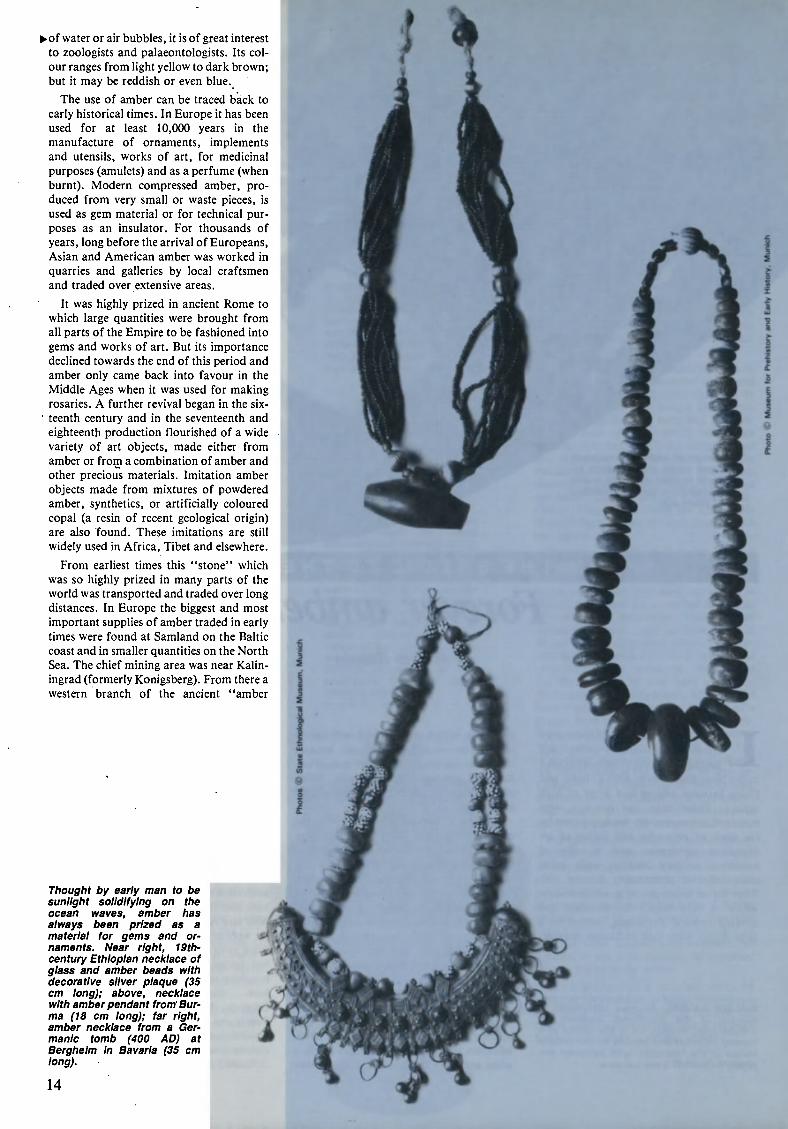
Thought by early man to be
sunlight solidifying on the
ocean waves, amber has
always been prized as a
material for gems and or¬
naments. Near right, 19th-
century Ethiopian necklace of
glass and amber beads with
decorative silver plaque (35
cm long); above, necklace
with amber pendant from Bur¬
ma (18 cm long); far right,
amber necklace from a Ger¬
manic tomb (400 AD) at
Bergheim in Bavaria (35 cm
long).
14
1
i
I
5
road" passed through the region of the
Lower Elbe and the Lower Rhine, then up
the Rhine through the Burgundian Gate or
along the Aare and the shores of Lake
Geneva to the Rhone, then following the
Rhone southwards as far as the famous
Greek port of Massilia (Marseilles). An im¬
portant eastern route ran from the Baltic
coast along the Vistula and through the ter¬
ritory of Kiev southeastwards to the Black
Sea. Here this Eastern amber route linked
up with the long and ancient overland con¬
nections to the Near East, central and east
Asia and India. But by far the most impor¬
tant amber route ran in Antiquity from the
North Sea or the Baltic across the Vistula,
through the Moravian Gate to Carnuntum,
on the Danube east of Vienna, then along
the edge of the eastern Alps and across them
southwards to the important trading centre
of Aquilea on the north Adriatic coast.
From earliest times small quantities of
amber were carried from northern Europe
by sea around the Iberian Peninsula to
Mediterranean centres of civilization and to
the Near East. However, the sea-borne
amber trade from the Adriatic and Black
Seas to southern Italy, Greece, north
Africa, the Levant and Egypt was more
important.
Even earlier there was a regular long¬
distance commercial traffic, by land or sea,
not only in the Near East, north Africa and
Europe but much further afield, from cen¬
tral, south, southeast and east Asia, as well
as from various parts of west and east
Africa. Thus precious amber reached nearly
every part of the ancient world, alongside a
wide variety of other goods traded over
huge distances, such as tin from Britain,
silver from Spain, incense from southern
Arabia, lapis Lazuli from Afghanistan,
ivory from Africa, furs from Siberia,
precious stones from India, and silk from
China. Some of the amber sold in Asia
came from Burma.
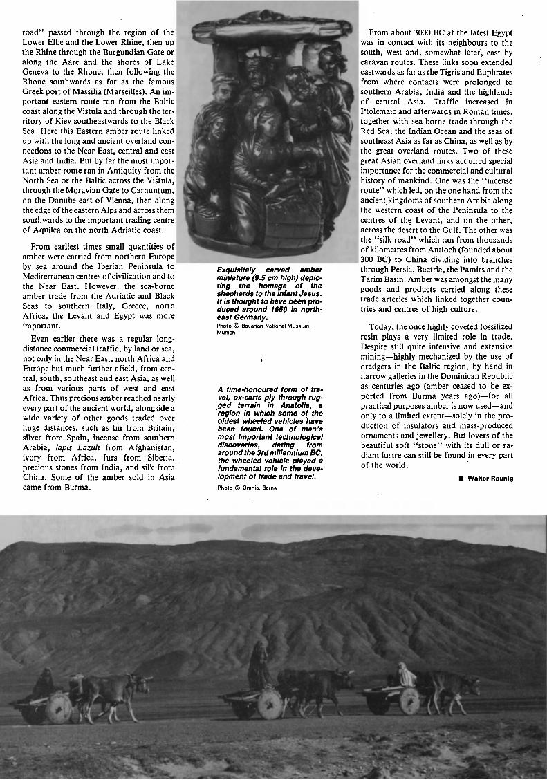
Exquisitely carved amber
miniature (9.5 cm high) deple¬
ting the homage of the
shepherds to the Infant Jesus.
It Is thought to have been pro¬
duced around 1650 in north¬
east Germany.
Photo © Bavarian National Museum,
Munich
A time-honoured form of tra¬
vel, ox-carts ply through rug¬
ged terrain In Anatolia, a
region In which some of the
oldest wheeled vehicles have
been found. One of man's
most Important technological
discoveries, dating from
around the 3rd millennium BC,
the wheeled vehicle played a
fundamental role In the deve¬
lopment of trade and travel.
Photo © Omnia, Berne
From about 3000 BC at the latest Egypt
was in contact with its neighbours to the
south, west and, somewhat later, east by
caravan routes. These links soon extended
eastwards as far as the Tigris and Euphrates
from where contacts were prolonged to
southern Arabia, India and the highlands
of central Asia. Traffic increased in
Ptolemaic and afterwards in Roman times,
together with sea-borne trade through the
Red Sea, the Indian Ocean and the seas of
southeast Asia as far as China, as well as by
the great overland routes. Two of these
great Asian overland links acquired special
importance for the commercial and cultural
history of mankind. One was the "incense
route" which led, on the one hand from the
ancient kingdoms of southern Arabia along
the western coast of the Peninsula to the
centres of the Levant, and on the other,
across the desert to the Gulf. The other was
the "silk road" which ran from thousands
of kilometres from Antioch (founded about
300 BC) to China dividing into branches
through Persia, Bactria, the Pamirs and the
Tarim Basin. Amber was amongst the many
goods and products carried along these
trade arteries which linked together coun¬
tries and centres of high culture.
Today, the once highly coveted fossilized
resin plays a very limited role in trade.
Despite still quite intensive and extensive
mininghighly mechanized by the use of
dredgers in the Baltic region, by hand in
narrow galleries in the Dominican Republic
as centuries ago (amber ceased to be ex¬
ported from Burma years ago)for all
practical purposes amber is now used and
only to a limited extentsolely in the pro¬
duction of insulators and mass-produced
ornaments and jewellery. Bui lovers of the
beautiful soft "stone" with its dull or ra¬
diant lustre can still be found in every part
of the world.
Walter Raunlg
*4r*â A***
Im- 9SS -
,*L
' *--nr_ ... JJ *Ä *4
HrFI^1 ^'7 *\
V
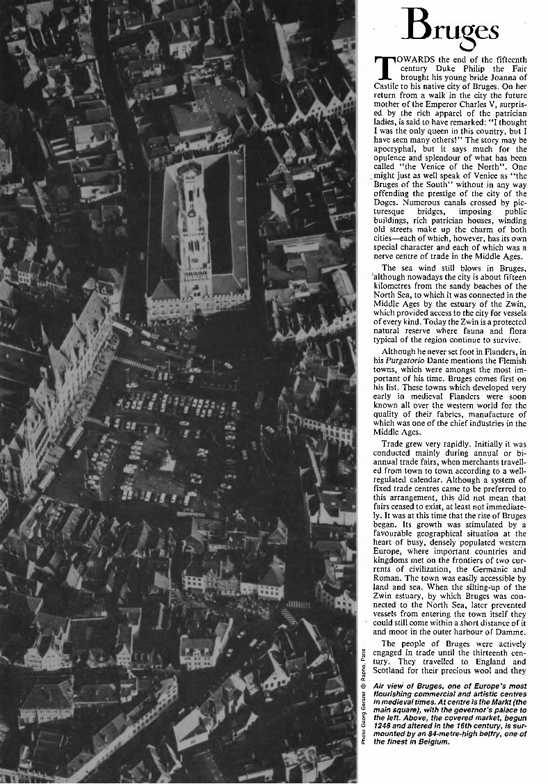
BrueesS(TOWARDS the end of the fifteenth
century Duke Philip the Fair
brought his young bride Joanna of
Castile to his native city of Bruges. On her
return from a walk in the city the future
mother of the Emperor Charles V, surpris¬
ed by the rich apparel of the patrician
ladies, is said to have remarked: "I thought
I was the only queen in this country, but I
have seen many others!" The story may be
apocryphal, but it says much for the
opulence and splendour of what has been
called "the Venice of the North". One
, might just as well speak of Venice as "the
Bruges of the South" without in any way
offending the prestige of the city of the
Doges. Numerous canals crossed by pic¬
turesque bridges, imposing public
buildings, rich patrician houses, winding
old streets make up the charm of both
cities each of which, however, has its own
special character and each of which was a
nerve centre of trade in the Middle Ages.
The sea wind still blows in Bruges,
"although nowadays the city is about fifteen
kilometres from the sandy beaches of the
North Sea, to which it was connected in the
Middle Ages by the estuary of the Zwin,
which provided access to the city for vessels
of every kind. Today the Zwin is a protected
natural reserve where fauna and flora
typical of the region continue to survive.
Although he never set foot in Flanders, in
his Purgatorio Dante mentions the Flemish
towns, which were amongst the most im¬
portant of his time. Bruges comes first on
his list. These towns which developed very
early in medieval Flanders were soon
known all over the western world for the
quality of their fabrics, manufacture of
which was one of the chief industries in the
Middle Ages.
Trade grew very rapidly. Initially it was
conducted mainly during annual or bi¬
annual trade fairs, when merchants travell¬
ed from town to town according to a well-
regulated calendar. Although a system of
fixed trade centres came to be preferred to
this arrangement, this did not mean that
fairs ceased to exist, at least not immediate¬
ly. It was at this time that the rise of Bruges
began. Its growth was stimulated by a
favourable geographical situation at the
heart of busy, densely populated western
Europe, where important countries and
kingdoms met on the frontiers of two cur¬
rents of civilization, the Germanic and
Roman. The town was easily accessible by
land and sea. When the silting-up of the
Zwin estuary, by which Bruges was con¬
nected to the North Sea, later prevented
vessels from entering the town itself they
could still come within a short distance of it
and moor in the outer harbour of Damme.
The people of Bruges were actively
engaged in trade until the thirteenth cen¬
tury. They travelled to England and
Scotland for their precious wool and they
Air view of Bruges, one of Europe's most
flourishing commercial and artistic centres
in medieval times. At centre is the Markt (the
main square), with the governor's palace to
the left. Above, the covered market, begun
1248 and altered in the 16th century, is sur¬
mounted by an 84-metre-high belfry, one of
the finest in Belgium.
nim
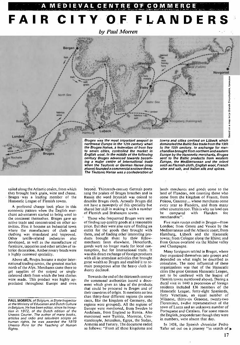
A M ED I EVA L C E N T R E OF C O M M É R CE
FAIR CITY OF FLANDERS
by Paul Aforren
-J^**¿0F
Bruges was the' most important seaport in
northwest Europe in the 12th century when
the Bruges Hanse, a federation of from five
to seven cities, controlled the market in
English wool. In the middle of the following
century Bruges advanced towards becom¬
ing a major centre of international trade
when the Teutonic or German Hanse (map
above) founded a commercial enclave there.
The Teutonic Hanse was a confederation of
towns and cities centred on Lübeck which
dominated the Baltic Sea trade from the 13th
to the 15th century. In exchange for mer¬
chandise brought from northern and eastern
Europe by the Hanseatic merchants, Bruges
sent to the Baltic products from western
Europe, the Mediterranean and the orient
such as Flemish cloth, English wool, French
wine and salt, and Italian silk and spices.
sailed along the Atlantic coasts, from which
they brought back grain, wine and cheese.
Bruges was a leading member of the
Hanseatic League of Flemish towns.
A profound change took place in this
economic pattern when the English mer¬
chant adventurers started to bring wool to
the continent themselves. Bruges gave up
active trade and concentrated on other ac¬
tivities. First it became an industrial town
where the manufacture of cloth and
clothing was stimulated and improved.
Other textile-related industries also
developed, as well as the manufacture of
furniture, tapestries and other articles of in¬
terior decoration. Amber rosary beads were
a highly esteemed speciality.
Above all, Bruges became a major inter¬
national trading centre, the greatest market
north of the Alps. Merchants came there to
get supplies of the striped or single-
coloured cloth from which the best clothes
were made. This product was highly ap¬
preciated throughout Europe and even
PAUL MORREN, of Belgium, is State Inspector
at the Ministry of Education and Dutch Culture
in Belgium. He has been editor, since its incep¬
tion in 1972, of the Dutch edition of the
Unesco Courier. The author of many books,
articles and radio and television scripts on
human rights, he was awarded the 1979
Unesco Prize for the Teaching of Human
Rights.
beyond. Thirteenth-century German poets
sang the praises of Bruges breeches and in
Russia the word bryukish was coined to
describe Bruges cloth. Actually Bruges did
not have a monopoly of this speciality but
shared her skill in making it with a number
of Flemish and Brabançon towns.
Those who frequented Bruges were sure
of finding top quality goods at a reasonable
price. But they were also sure of finding an
outlet for the goods they brought with
them, and of finding other interesting pro¬
ducts brought there by their fellow-
merchants from elsewhere. Henceforth,
goods werfe no longer made for local con¬
sumption, but for international trade. It
was this direct exchange of foreign products
with all its attendant activities that brought
great wealth to Bruges and enabled it to re¬
main prosperous after the heavy cloth in¬
dustry declined.
Towards the end of the thirteenth century
the communal authorities issued a docu¬
ment which gives an idea of the products
that could be procured in Bruges and of
their countries of origin. It mentions no less
than thirty-four different regions (in some
cases, like the kingdom of Germany, the
regions were grouped). All the regions of
Europe were mentioned, from Sweden to
Andalusia, from England to Russia. Also
mentioned were Tunisia, Morocco, Con¬
stantinople, Jerusalem, Egypt, the Sudan,
Armenia and Tartary. The document ended
as follows: "From all these kingdoms and
lands merchants and goods come to the
land of Flanders, not counting those who
come from the kingdom of France, from
Poitou, Gascony... whose merchants come
every year to Flanders, and from many
other countries too. This is why no land can
be compared with Flanders for
merchandise".
Five main routes ended in Bruges from
London; from Genoa and Venice by the
Mediterranean and the Atlantic coast; from
Hamburg, Lübeck and the Hanseatic
towns; from Cologne along the Rhine; and
from Genoa overland via the Rhône valley
and Champagne.
Many foreigners settled in Bruges, where
they organized themselves into groups and
depended on what might be described as
consulates. The most influential of these
organizations was that of the Hanseatic
cities (the great German Hanseatic League,
not to be confused with the league of
Flemish towns mentioned above). During a
ducal visit in 1440 a procession of foreign
residents included 136 members of the
Hanseatic League, forty-eight Spaniards,
forty Venetians, an equal number of
Milanese, thirty-six Genoese, twenty-two
Florentines, twelve representatives of the
town of Lucca and an unknown number of
Portuguese and Catalans. For some reason
the English, preponderant though they were
in numbers, were absent that day.
In 1438, the Spanish chronicler Pedro
Tafur set out on a journey "in search of ^
17
adventure, and opportunities to prove my
personal merit and that of my family and
country". He had the excellent idea of
keeping a diary of his journey in which he
confides that he found Bruges to be
superior to Venice, because it was a
meeting-place for people from many coun¬
tries, whereas on the shores of the Adriatic
the natives attended to everything
themselves. "I have been told that on cer¬
tain days as many as 700 ships leave the
port. The capital of Flanders is a very big
town with pretty houses and fine streets. It
is densely populated and includes a great
many craftsmen. The town is full of
churches and convents as well as good inns.
Everything, including the administration of
justice, is organized in an exemplary man¬
ner. The inhabitants display boundless ac¬
tivity. Merchandise from all parts of the
world is offered for sale in Bruges."
The comparison between Bruges and
Venice does not end with their sites and
economic activities. Here is the account of
Leo von Rozmital, brother-in-law of the
King of Bohemia, who in 1466 travelled
through Germany, Belgium, England,
France, Spain, Portugal and Italy, accom¬
panied by a suite of forty gentlemen and
servants. "In this country, but especially in
Bruges, it is customary at the beginning of
carnival for people of importance to
disguise themselves, vying with each other
to have the richest apparel. The colour
chosen by the lord is also worn by his ser¬
vants. But the wearing of masks prevents
their being identified. Thus attired, they go
wherever there are balls and other enter¬
tainments, accompanied by players of
trumpets and drums."
In the fifteenth century the many feudal
principalities which had arisen on what is
today the territory of Belgium and the
Netherlands were united under the sceptre
of the Dukes of Burgundy. For several
decades this extensive State was the richest
and most powerful in western Europe. It
had no fixed capital, but Bruges was one of
the favourite places of residence of the
Dukes and the Court. It was here that
Charles the Bold and Margaret of York
were married and that Philip the Good
founded the Order of the Golden Fleece. It
was at Bruges that much of the splendour of
the Burgundian era was displayed. This in¬
cluded the development of music, the
flowering of secular and ecclesiastical flam¬
boyant Gothic and the fabulous school of
painting which began with Jan Van Eyck
and whose members have infelicitously
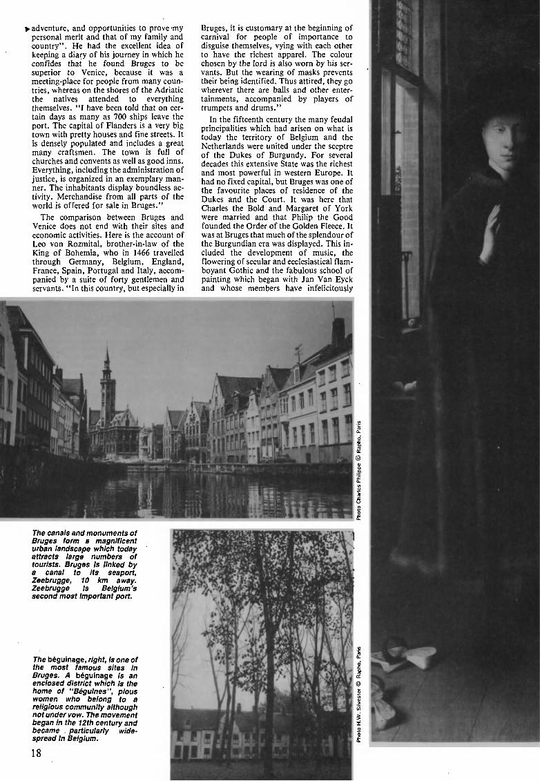
The canals and monuments of
Bruges form a magnificent
urban landscape which today
attracts large numbers of
tourists. Bruges Is linked by
a canal to Its seaport,
Zeebrugge, 10 km away.
Zeebrugge Is Belgium's
second most Important port.
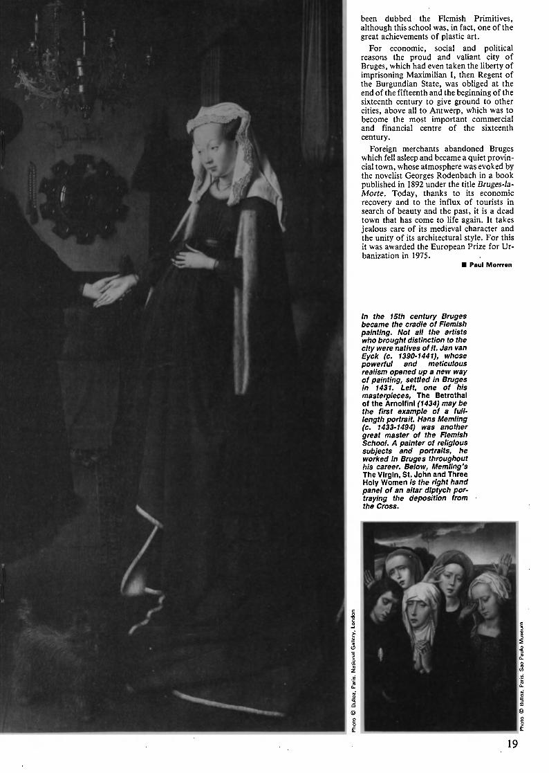
The béguinage, right, is one of
the most famous sites in
Bruges. A béguinage is an
enclosed district which Is the
home of "Béguines", pious
women who belong to a
religious community although
not under vow. The movement
began in the 12th century and
became . particularly wide¬
spread in Belgium.
18
been dubbed the Flemish Primitives,
although this school was, in fact, one of the
great achievements of plastic art.
For economic, social and political
reasons the proud and valiant city of
Bruges, which had even taken the liberty of
imprisoning Maximilian I, then Regent of
the Burgundian State, was obliged at the
end of the fifteenth and the beginning of the
sixteenth century to give ground to other
cities, above all to Antwerp, which was to
become the most important commercial
and financial centre of the sixteenth
century.
Foreign merchants abandoned Bruges
which fell asleep and became a quiet provin¬
cial town, whose atmosphere was evoked by
the novelist Georges Rodenbach in a book
published in 1892 under the title Bruges-la-
Morte. Today, thanks to its economic
recovery and to the influx of tourists in
search of beauty and the past, it is a dead
town that has come to life again. It takes
jealous care of its medieval character and
the unity of its architectural style. For this
it was awarded the European Prize for Ur¬
banization in 1975.
Paul Morrren
In the 15th century Bruges
became the cradle of Flemish
painting. Not all the artists
who brought distinction to the
city were natives of It. Jan van
Eyck (c. 1390-1441), whose
powerful and meticulous
realism opened up a new way
of painting, settled in Bruges
in 1431. Left, one of his
masterpieces, The Betrothal
of the Arnolfinl (1434) may be
the first example of a full-
length portrait. Hans Memling
(c. 1433-1494) was another
great master of the Flemish
School. A painter of religious
subjects and portraits, he
worked In Bruges throughout
his career. Below, Memling's
The Virgin, St. John and Three
Holy Women Is the right hand
panel of an altar diptych por¬
traying the deposition from
the Cross.
19
t*/****.
wwMiW
%¿ák
- 7 '
ä«!««»*?^?!^^
The life of spice
by Khoo Joo Ee
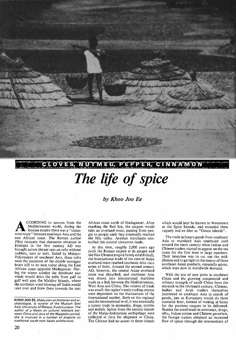
ACCORDING to sources from the
Mediterranean world, during the
Roman empire there was a "cinna¬
mon route" between southeast Asia and the
east African coast. The Roman author
Pliny recounts that cinnamon obtained in
Ethiopia in the first century AD was
brought across distant seas on rafts without
rudders, oars or sails. Sailed by Malayo-
Polynesians of southeast Asia, these rafts
were the ancestors of the double outrigger
boats still to be seen today along the East
African coast opposite Madagascar. Dur¬
ing the winter solstice the dominant east
winds would drive the rafts from gulf to
gulf well past the Maldive Islands, where
the northeast wind blowing off India would
take over and blow them towards the east
KHOO JOO EE, Malaysian art historian and ar¬
chaeologist, is curator of the Muzium Seni
Asia, University of Malaya, Kuala Lumpur. The
author of a thesis on cultural relations bet¬
ween China and Java of the Majapahit period,
she is involved in a number of projects on
traditional south-east Asian architecture.
African coast north of Madagascar. After
reaching the Red Sea, the cargoes would
take an overland route, passing from peo¬
ple to people until they eventually reached
the Nile valley. Arabian merchants con¬
trolled this coastal cinnamon trade.
At this time, roughly 2,000 years ago
(with the Roman empire at its apogee and
the Han Chinese empire firmly established),
the international trade of the central Asian
overland route reached southeast Asia via a
series of links. Around the second century
AD, however, the central Asian overland
route was disturbed, and southeast Asia
was drawn into international maritime
trade as a link between the Mediterranean,
West Asia and China. The volume of trade
was small: the region's early trading centres
were dependent on the fluctuations of the
international market. Both on the regional
and the international level, it was essentially
a luxury trade in aromatics, drugs, textiles
and metals. Spices from the eastern islands
of the Malay-Indonesian archipelago were
collected at Java for shipment to China.
The Chinese had no access to these islands
which would later be known to Westerners
as the Spice Islands, and recorded them
vaguely and en bloc as "Ocean Islands".
The trade in luxury goods from southeast
Asia to mainland Asia continued until
around the tenth century when Indian and
Chinese traders started to appear on the sea
route for the first time in large numbers.
Their intention was to cut out the mid¬
dlemen and to go right to the source of these
southeast Asian products, especially spices,
which were now in worldwide demand.
With the rise of new ports in southeast
China and the growing commercial and
military strength of south China from the
eleventh to the thirteenth century, Chinese,
Indian and Arab traders themselves
journeyed to southeast Asia in search of
goods, just as Europeans would do three
centuries later, instead of waiting at home
for the precious cargoes to be delivered.
Besides the usual trade in aromatics, drugs,
silks, Indian cotton and Chinese porcelain,
the foreign traders obtained an increased
flow of spices through the intermediary of
20
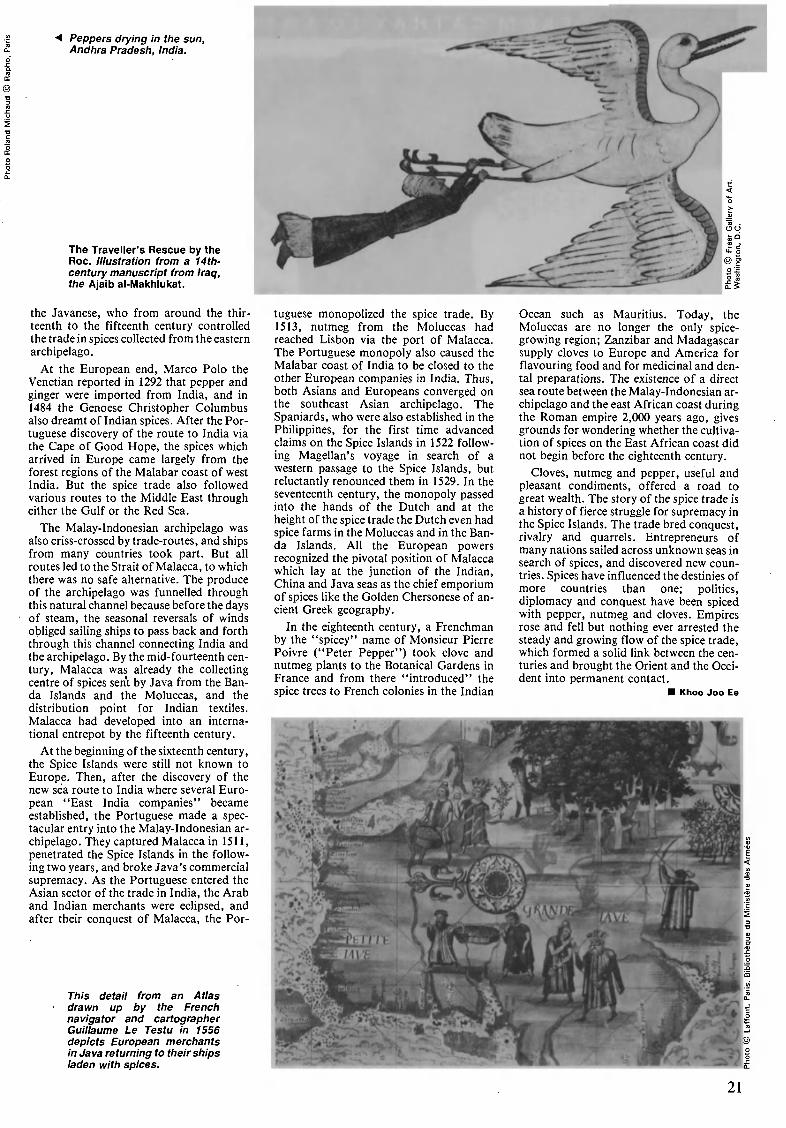
Peppers drying in the sun,
Andhra Pradesh, India.
The Traveller's Rescue by the
Roc. Illustration from a 14th-
century manuscript from Iraq,
the Ajaib al-Makhlukat.
the Javanese, who from around the thir¬
teenth to the fifteenth century controlled
the trade in spices collected from the eastern
archipelago.
At the European end, Marco Polo the
Venetian reported in 1292 that pepper and
ginger were imported from India, and in
1484 the Genoese Christopher Columbus
also dreamt of Indian spices. After the Por¬
tuguese discovery of the route to India via
the Cape of Good Hope, the spices which
arrived in Europe came largely from the
forest regions of the Malabar coast of west
India. But the spice trade also followed
various routes to the Middle East through
either the Gulf or the Red Sea.
The Malay-Indonesian archipelago was
also criss-crossed by trade-routes, and ships
from many countries took part. But all
routes led to the Strait of Malacca, to which
there was no safe alternative. The produce
of the archipelago was funnelled through
this natural channel because before the days
of steam, the seasonal reversals of winds
obliged sailing ships to pass back and forth
through this channel connecting India and
the archipelago. By the mid- fourteenth cen¬
tury, Malacca was already the collecting
centre of spices sent by Java from the Ban-
da Islands and the Moluccas, and the
distribution point for Indian textiles.
Malacca had developed into an interna¬
tional entrepot by the fifteenth century.
At the beginning of the sixteenth century,
the Spice Islands were still not known to
Europe. Then, after the discovery of the
new sea route to India where several Euro¬
pean "East India companies" became
established, the Portuguese made a spec¬
tacular entry into the Malay-Indonesian ar¬
chipelago. They captured Malacca in 1511,
penetrated the Spice Islands in the follow¬
ing two years, and broke Java's commercial
supremacy. As the Portuguese entered the
Asian sector of the trade in India, the Arab
and Indian merchants were eclipsed, and
after their conquest of Malacca, the Por-
This detail from an Atlas
drawn up by the French
navigator and cartographer
Guillaume Le Testu in 1556
depicts European merchants
in Java returning to their ships
laden with spices.
W^
tugúese monopolized the spice trade. By
1513, nutmeg from the Moluccas had
reached Lisbon via the port of Malacca.
The Portuguese monopoly also caused the
Malabar coast of India to be closed to the
other European companies in India. Thus,
both Asians and Europeans converged on
the southeast Asian archipelago. The
Spaniards, who were also established in the
Philippines, for the first time advanced
claims on the Spice Islands in 1522 follow¬
ing Magellan's voyage in search of a
western passage to the Spice Islands, but
reluctantly renounced them in 1529. In the
seventeenth century, the monopoly passed
into the hands of the Dutch and at the
height of the spice trade the Dutch even had
spice farms in the Moluccas and in the Ban-
da Islands. All the European powers
recognized the pivotal position of Malacca
which lay at the junction of the Indian,
China and Java seas as the chief emporium
of spices like the Golden Chersonese of an¬
cient Greek geography.
In the eighteenth century, a Frenchman
by the "spicey" name of Monsieur Pierre
Poivre ("Peter Pepper") took clove and
nutmeg plants to the Botanical Gardens in
France and from there "introduced" the
spice trees to French colonies in the Indian
Ocean such as Mauritius. Today, the
Moluccas are no longer the only spice-
growing region; Zanzibar and Madagascar
supply cloves to Europe and America for
flavouring food and for medicinal and den¬
tal preparations. The existence of a direct
sea route between the Malay-Indonesian ar¬
chipelago and the east African coast during
the Roman empire 2,000 years ago, gives
grounds for wondering whether the cultiva¬
tion of spices on the East African coast did
not begin before the eighteenth century.
Cloves, nutmeg and pepper, useful and
pleasant condiments, offered a road to
great wealth. The story of the spice trade is
a history of fierce struggle for supremacy in
the Spice Islands. The trade bred conquest,
rivalry and quarrels. Entrepreneurs of
many nations sailed across unknown seas in
search of spices, and discovered new coun¬
tries. Spices have influenced the destinies of
more countries than one; politics,
diplomacy and conquest have been spiced
with pepper, nutmeg and cloves. Empires
rose and fell but nothing ever arrested the
steady and growing flow of the spice trade,
which formed a solid link between the cen¬
turies and brought the Orient and the Occi¬
dent into permanent contact.
Khoo Joo Ee
21
FROM C AT H A Y T O Ä INTT I O C H
A SILKEN
FROM EASTi
by Ma Yong
IN 1958, archaeologists working at a
site at Qian Shan Yang, in Wuxing
district, Zhejiang Province, discov¬
ered the earliest fabrics yet found anywhere
in the world. Here, in China's Tai Lake
region, long famous for its silk industry,
among other cultural relics of the Neolithic
Age, they found relics of silk fabrics in¬
cluding silk yarn, silk belts and pieces of
spun silk fabric.
Examination showed that the pieces of
fabric were woven from the silk of domestic
silkworms which had been reeled before
weaving. The weave is plain, the yarn of
both warp and weft is almost identical in
thickness and the average density of the
cloth is of forty-seven threads per cen¬
timetre. Chronological tests indicate a date
for these fabrics of 2,750 ± 100 years. In
view of the advanced levels of the technique
used, the silk textile industry had already
evolved beyond the primitive stage when
these fabrics were made, and it can safely be
assumed that China's silk industry has a
history of more than 5,000 years.
We do not Know for certain how silk first
came to be shipped abroad, but China's silk
industry must have been experiencing a
MA YONG, of China, is director of the Ancient
Sino-Foreign Relations section of the Institute
of History of the Chinese Academy of Social
Sciences. Vice-Chairman of the Chinese
Society for Central Asian Studies, he is a
specialist in the history of the Xinjiang region
of China and the author of The Historical
Relics of Xinjiang Region (1978) as well as
numerous studies on the history and ar¬
chaeology of Xinjiang. He is a member of the
International Editorial Council of A History of
the Civilization of Central Asia, sponsored by
Unesco, and is one of the editors of the
History's third volume.
HIGHWAY
TO WEST
period of great prosperity when its much-
prized products began to spread to the West
sometime between the sixth and the fifth
century BC.
During the early years of the Spring and
Autumn Period (770 to 476 BC), the Jin and
Qin Kingdoms, situated in the southern and
central part of Shanxi Province and in the
southeastern part of Gansu Province, had
extended their influence to the region of the
nomadic peoples to the northwest, thus
establishing closer contacts with the in¬
habitants of the regions of the Great Bend
of the Huang He River (Yellow River) and
the corridor west of the Huang He. It was
probably from there that the first shipments
of silk to the West were made. However, it
seems that at that time there was no direct
established trade between the Chinese in¬
terior and the regions of central Asia. Silk
was carried to the Eurasian hinterland by
nomadic tribes such as the Xianyun and the
Yue-chi and from there spread to Europe
via the Scythians.
Chinese silk fabrics have been unearthed
from the huge stone-capped tomb of a fifth-
century chief of the Altai region of the
USSR. Among them was a splendid silk
saddle-cloth with a phcenix embroidered on
it. Beside it lay a bronze mirror, also of
Chinese manufacture. Silk fabrics and silk
fringes sewn on to woollen garments have
also been found in sixth- and fifth-century
BC graves in Greece, Germany and Luxem¬
bourg. All this would seem to indicate that
the oldest Silk Road started at the Great
Bend of the Huang He River, passing to the
north of the Alps via the eastern and nor-
In 1971, Chinese archaeologists working on
a site at Mawangdul, near Chang-sha, Hunan
Province, discovered three tombs, one of
which was still Intact, containing a wealth of
valuable artefacts, all of which are over two
thousand years old. They Included silk
garments and coverings and a number of
documents printed on bamboo and silk. The
tombs are believed to be those of a high-
ranking nobleman, the Marquis Da, his wife
and son, who lived during the early years of
the Western Han dynasty (202 BC to 9 AD,
approx.). Right, fragment of a copy, printed
on silk, of the Tao Te Ching (The Book of the
Way and Its Power), one of the most sacred
books of Taolst literature. Above, a silk
gauze dress, 1.28 metres long.
them parts of the Altai and across the
steppes of Kazakhstan and south Russia, to
reach the shores of the Black Sea and on to
regions inhabited by Greeks and Etruscans.
Although some silk from China reached
Europe via this route, it can hardly be said
that a proper trade route existed at this
time. The Greeks, whose curiosity was
aroused by the novel luxury of silk, had on¬
ly the vaguest ideas about the far off eastern
land they called simply the "Land of Silk",
a name which persisted until the Roman
era.
Chinese silk may also have been in¬
troduced to India at that time. It is said that
the word Cinapatta, which means "Chinese
silks", is mentioned in the Artha-sastra
(Handbook of the King), written by the
fourth-century BC Indian writer Kautiliya.
Furthermore, the Sanskrit vocabulary in¬
dicates that ancient Indians already knew
that silk was a secretion from a kind of
insect.
However, the credit for the opening of
the real Silk Road belongs to Emperor Wu
of the Han dynasty (middle of the second
22
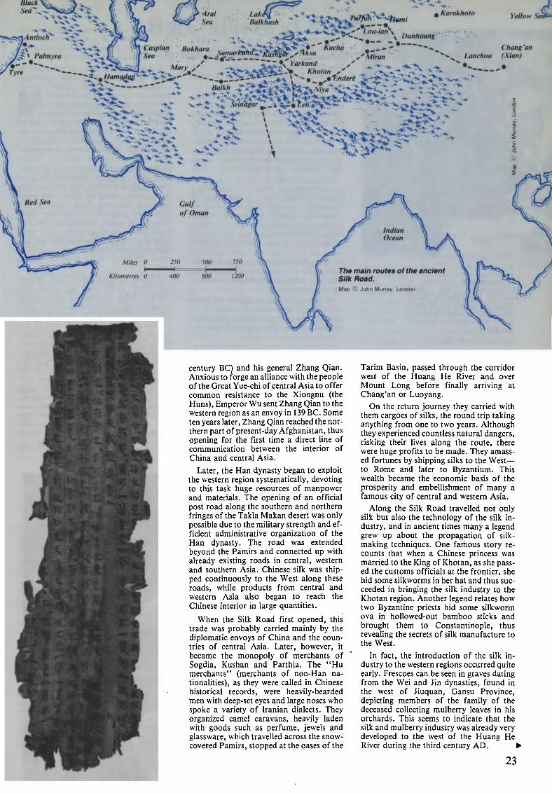
Lak.
Balkhash
-xAntioch
vy-^ * Palmyra
7>re
pâfàr^biunia Karakhoto
"" "* *» # Hamadac
Caspian. Bokhara c ^^^i^^ ^f'' ' Kucha '' """***
iV-1».
<.
J*x'* Yarkand2¡.-'>»_ Khotan
'V
V k£ V» Srinhgar % %Z% leh^\><^- -~ -i*-^'V->>-^«k\\
Lanchou
^»
KeHoiv Sea
Chang 'an
(Xian)
*^it:
century BC) and his general Zhang Qian.
Anxious to forge an alliance with the people
of the Great Yue-chi of central Asia to offer
common resistance to the Xiongnu (the
Huns), Emperor Wu sent Zhang Qian to the
western region as an envoy in 139 BC. Some
ten years later, Zhang Qian reached the nor¬
thern part of present-day Afghanistan, thus
opening for the first time a direct line of
communication between the interior of
China and central Asia.
Later, the Han dynasty began to exploit
the western region systematically, devoting
to this task huge resources of manpower
and materials. The opening of an official
post road along the southern and northern
fringes of the Takla Makan desert was only
possible due to the military strength and ef¬
ficient administrative organization of the
Han dynasty. The road was extended
beyond the Pamirs and connected up with
already existing roads in central, western
and southern Asia. Chinese silk was ship¬
ped continuously to the West along these
roads, while products from central and
western Asia also began to reach the
Chinese interior in large quantities.
When the Silk Road first opened, this
trade was probably carried mainly by the
diplomatic envoys of China and the coun¬
tries of central Asia. Later, however, it
became the monopoly of merchants of
Sogdia, Kushan and Parthia. The "Hu
merchants" (merchants of non-Han na¬
tionalities), as they were called in Chinese
historical records, were heavily-bearded
men with deep-set eyes and large noses who
spoke a variety of Iranian dialects. They
organized camel caravans, heavily laden
with goods such as perfume, jewels and
glassware, which travelled across the snow-
covered Pamirs, stopped at the oases of the
Tarim Basin, passed through the corridor
west of the Huang He River and over
Mount Long before finally arriving at
Chang'an or Luoyang.
On the return journey they carried with
them cargoes of silks, the round trip taking
anything from one to two years. Although
they experienced countless natural dangers,
risking their lives along the route, there
were huge profits to be made. They amass¬
ed fortunes by shipping silks to the West
to Rome and later to Byzantium. This
wealth became the economic basis of the
prosperity and embellishment of many a
famous city of central and western Asia.
Along the Silk Road travelled not only
silk but also the technology of the silk in¬
dustry, and in ancient times many a legend
grew up about the propagation of silk-
making techniques. One famous story re¬
counts that when a Chinese princess was
married to the King of Khotan, as she pass¬
ed the customs officials at the frontier, she
hid some silkworms in her hat and thus suc¬
ceeded in bringing the silk industry to the
Khotan region. Another legend relates how
two Byzantine priests hid some silkworm
ova in hollowed-out bamboo sticks and
brought them to Constantinople, thus
revealing the secrets of silk manufacture to
the West.
In fact, the introduction of the silk in¬
dustry to the western regions occurred quite
early. Frescoes can be seen in graves dating
from the Wei and Jin dynasties, found in
the west of Jiuquan, Gansu Province,
depicting members of the family of the
deceased collecting mulberry leaves in his
orchards. This seems to indicate that the
silk and mulberry industry was already very
developed to the west of the Huang He
River during the third century AD.
23
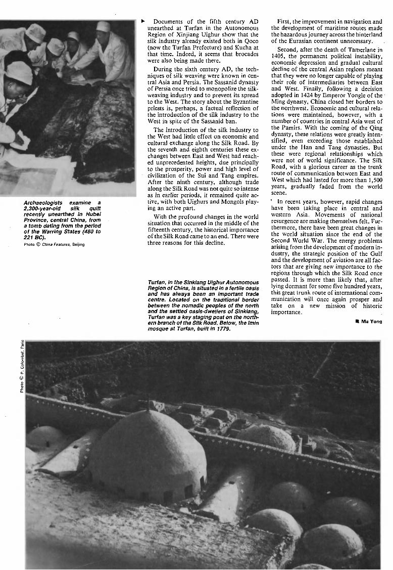
Archaeologists examine a
2,300-year-old silk quilt
recently unearthed in Hubei
Province, central China, from
a tomb dating from the period
of the Warring States (480 to
221 BC).
Photo © China Features, Beijing
Documents of the fifth century AD
unearthed at Turfan in the Autonomous
Region of Xinjiang Uighur show that the
silk industry already existed both in Qoco
(now the Turfan Prefecture) and Kucha at
that time. Indeed, it seems that brocades
were also being made there.
During the sixth century AD, the tech¬
niques of silk weaving were known in cen¬
tral Asia and Persia. The Sassanid dynasty
of Persia once tried to monopolize the silk-
weaving industry and to prevent its spread
to the West. The story about the Byzantine
priests is, perhaps, a factual reflection of
the introduction of the silk industry to the
West in spite of the Sassanid ban.
The introduction of the silk industry to
the West had little effect on economic and
cultural exchange along the Silk Road. By
the seventh and eighth centuries these ex¬
changes between East and West had reach¬
ed unprecedented heights, due principally
to the prosperity, power and high level of
civilization of the Sui and Tang empires.
After the ninth century, although trade
along the Silk Road was not quite so intense
as in earlier periods, it remained quite ac¬
tive, with both Uighurs and Mongols play¬
ing an active part.
With the profound changes in the world
situation that occurred in the middle of the
fifteenth century, the historical importance
of the Silk Road came to an end. There were
three reasons for this decline.
Turfan, in the Sinkiang Uighur Autonomous
Region of China, is situated in a fertile oasis
and has always been an important trade
centre. Located on the traditional border
between the nomadic peoples of the north
and the settled oasis-dwellers of Sinkiang,
Turfan was a key staging post on the north¬
ern branch of the Silk Road. Below, the Imin
mosque at Turfan, built in 1779.
First, the improvement in navigation and
the development of maritime routes made
the hazardous journey across the hinterland
of the Eurasian continent unnecessary.
Second, after the death of Tamerlane in
1405, the permanent political instability,
economic depression and gradual cultural
decline of the central Asian regions meant
that they were no longer capable of playing
their role of intermediaries between East
and West. Finally, following a decision
adopted in 1424 by Emperor Yongle of the
Ming dynasty, China closed her borders to
the northwest. Economic and cultural rela¬
tions were maintained, however, with a
number of countries in central Asia west of
the Pamirs. With the coming of the Qing
dynasty, these relations were greatly inten¬
sified, even exceeding those established
under the Han and Tang dynasties. But
these were regional relationships which
were not of world significance. The Silk
Road, with a glorious career as the trunk
route of communication between East and
West which had lasted for more than 1,500
years, gradually faded from the world
scene.
° In recent years, however, rapid changes
have been taking place in central and
western Asia. Movements of national
resurgence are making themselves felt. Fur¬
thermore, there have been great changes in
the world situation since the end of the
Second World War. The energy problems
arising from the development of modern in¬
dustry, the strategic position of the Gulf
and the development of aviation are all fac¬
tors that are giving new importance to the
regions through which the Silk Road once
passed. It is more than likely that, after
lying dormant for some five hundred years,
this great trunk route of international com¬
munication will once again prosper and
take on a new mission of historic
importance.
Ma Yong
©
-r
v>
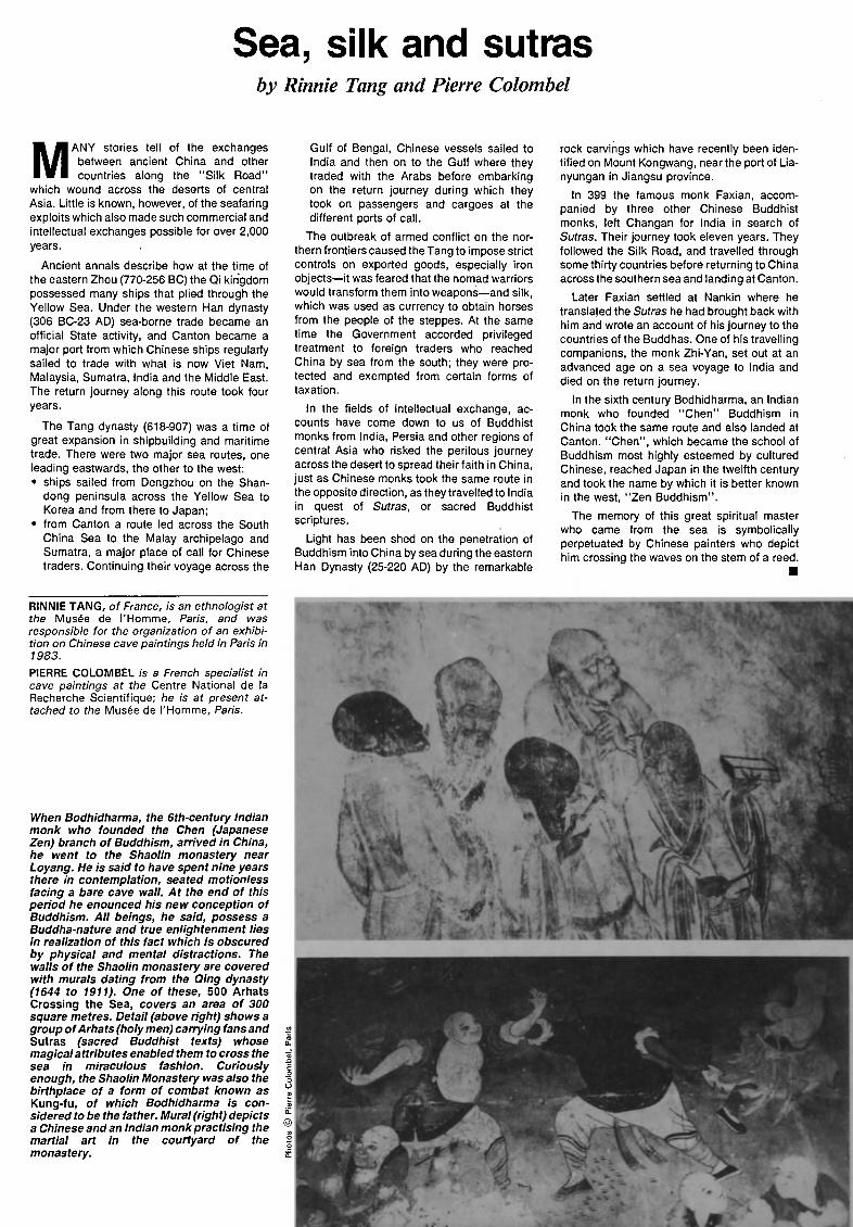
Sea, silk and sutras
by Rinnie Tang and Pierre Colombel
MANY stories tell of the exchanges
between ancient China and other
countries along the "Silk Road"
which wound across the deserts of central
Asia. Little is known, however, of the seafaring
exploits which also made such commercial and
intellectual exchanges possible for over 2,000
years.
Ancient annals describe how at the time of
the eastern Zhou (770-256 BC) the Qi kingdom
possessed many ships that plied through the
Yellow Sea. Under the western Han dynasty
(306 BC-23 AD) sea-borne trade became an
official State activity, and Canton became a
major port from which Chinese ships regularly
sailed to trade with what is now Viet Nam,
Malaysia, Sumatra, India and the Middle East.
The return journey along this route took four
years.
The Tang dynasty (618-907) was a time of
great expansion in shipbuilding and maritime
trade. There were two major sea routes, one
leading eastwards, the other to the west:
ships sailed from Dengzhou on the Shan¬
dong peninsula across the Yellow Sea to
Korea and from there to Japan;
from Canton a route led across the South
China Sea to the Malay archipelago and
Sumatra, a major place of call for Chinese
traders. Continuing their voyage across the
Gulf of Bengal, Chinese vessels sailed to
India and then on to the Gulf where they
traded with the Arabs before embarking
on the return journey during which they
took on passengers and cargoes at the
different ports of call.
The outbreak of armed conflict on the nor¬
thern frontiers caused the Tang to impose strict
controls on exported goods, especially iron
objectsit was feared that the nomad warriors
would transform them into weaponsand silk,
which was used as currency to obtain horses
from the people of the steppes. At the same
time the Government accorded privileged
treatment to foreign traders who reached
China by sea from the south; they were pro¬
tected and exempted from certain forms of
taxation.
In the fields of intellectual exchange, ac¬
counts have come down to us of Buddhist
monks from India, Persia and other regions of
central Asia who risked the perilous journey
across the desert to spread their faith in China,
just as Chinese monks took the same route in
the opposite direction, as they travelled to India
in quest of Sutras, or sacred Buddhist
scriptures.
Light has been shed on the penetration of
Buddhism into China by sea during the eastern
Han Dynasty (25-220 AD) by the remarkable
rock carvings which have recently been iden¬
tified on Mount Kongwang, near the port of Lia-
nyungan in Jiangsu province.
In 399 the famous monk Faxian, accom¬
panied by three other Chinese Buddhist
monks, left Changan for India in search of
Sutras. Their journey took eleven years. They
followed the Silk Road, and travelled through
some thirty countries before returning to China
across the southern sea and landing at Canton.
Later Faxian settled at Nankin where he
translated the Sutras he had brought back with
him and wrote an account of his journey to the
countries of the Buddhas. One of his travelling
companions, the monk Zhi-Yan, set out at an
advanced age on a sea voyage to India and
died on the return journey.
In the sixth century Bodhidharma, an Indian
monk who founded "Chen" Buddhism in
China took the same route and also landed at
Canton. "Chen", which became the school of
Buddhism most highly esteemed by cultured
Chinese, reached Japan in the twelfth century
and took the name by which it is better known
in the west, "Zen Buddhism".
The memory of this great spiritual master
who came from the sea is symbolically
perpetuated by Chinese painters who depict
him crossing the waves on the stem of a reed.
RINNIE TANG, of France, is an ethnologist at
the Musée de l'Homme, Paris, and was
responsible for the organization of an exhibi¬
tion on Chinese cave paintings held in Paris in
1983.
PIERRE COLOMBEL is a French specialist in
cave paintings at the Centre National de la
Recherche Scientifique; he is at present at¬
tached to the Musée de l'Homme, Paris.
When Bodhidharma, the 6th-century Indian
monk who founded the Chen (Japanese
Zen) branch of Buddhism, arrived in China,
he went to the Shaolln monastery near
Loyang. He is said to have spent nine years
there in contemplation, seated motionless
facing a bare cave wall. At the end of this
period he enounced his new conception of
Buddhism. All beings, he said, possess a
Buddha-nature and true enlightenment lies
in realization of this fact which is obscured
by physical and mental distractions. The
walls of the Shaolin monastery are covered
with murals dating from the Qing dynasty
(1644 to 1911). One of these, 500 Arhats
Crossing the Sea, covers an area of 300
square metres. Detail (above right) shows a
group ofArhats (holy men) carrying fans and
Sutras (sacred Buddhist texts) whose
magicalattributes enabled them to cross the
sea in miraculous fashion. Curiously
enough, the Shaolin Monastery was also the
birthplace of a form of combat known as
Kung-fu, of which Bodhidharma is con¬
sidered to be the father. Mural (right) depicts
a Chinese andan Indian monk practising the
martial art in the courtyard of the
monastery.
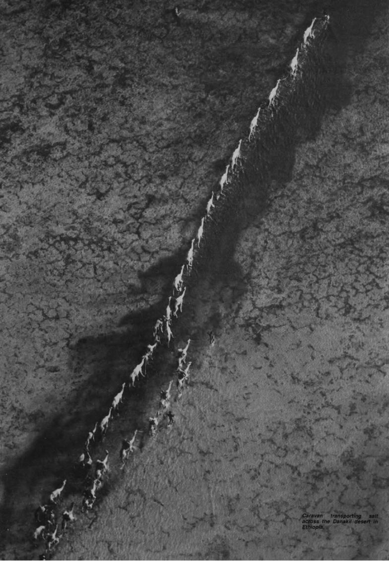
:^
Jar
&*
>:
'>>*
Caravan transporting salt
across the Danakil desert in
Ethiopia.
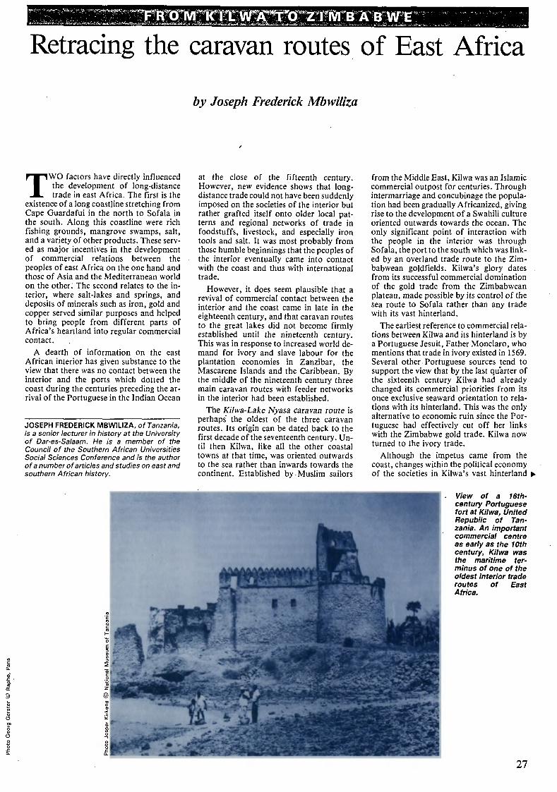
Ttrcrw»nrn:w3rTtne*r'fiiii,,B: a b we
Retracing the caravan routes of East Africa
by Joseph Frederick Mbwiliza
TWO factors have directly influenced
the development of long-distance
trade in east Africa. The first is the
existence of a long coastline stretching from
Cape Guardafui in the north to Sofala in
the south. Along this coastline were rich
fishing grounds, mangrove swamps, salt,
and a variety of other products. These serv¬
ed as major incentives in the development
of commercial relations between the
peoples of east Africa on the one hand and
those of Asia and the Mediterranean world
on the other. The second relates to the in¬
terior, where salt-lakes and springs, and
deposits of minerals such as iron, gold and
copper served similar purposes and helped
to bring people from different parts of
Africa's heartland into regular commercial
contact.
A dearth of information on the east
African interior has given substance to the
view that there was no contact between the
interior and the ports which dotted the
coast during the centuries preceding the ar¬
rival of the Portuguese in the Indian Ocean
JOSEPH FREDERICK MBWILIZA, of Tanzania,
is a senior lecturer in history at the University
of Dar-es-Salaam. He is a member of the
Council of the Southern African Universities
Social Sciences Conference and is the author
of a number of articles and studies on east and
southern African history.
at the close of the fifteenth century.
However, new evidence shows that long¬
distance trade could not have been suddenly
imposed on the societies of the interior but
rather grafted itself onto older local pat¬
terns and regional networks of trade in
foodstuffs, livestock, and especially iron
tools and salt. It was most probably from
these humble beginnings that the peoples of
the interior eventually came into contact
with the coast and thus with international
trade.
However, it does seem plausible that a
revival of commercial contact between the
interior and the coast came in late in the
eighteenth century, and that caravan routes
to the great lakes did not become firmly
established until the nineteenth century.
This was in response to increased world de¬
mand for ivory and slave labour for the
plantation economies in Zanzibar, the
Mascarene Islands and the Caribbean. By
the middle of the nineteenth century three
main caravan routes with feeder networks
in the interior had been established.
The Kilwa-Lake Nyasa caravan route is
perhaps the oldest of the three caravan
routes. Its origin can be dated back to the
first decade of the seventeenth century. Un¬
til then Kilwa, like all the other coastal
towns at that time, was oriented outwards
to the sea rather than inwards towards the
continent. Established by Muslim sailors
from the Middle East, Kilwa was an Islamic
commercial outpost for centuries. Through
intermarriage and concubinage the popula¬
tion had been gradually Africanized, giving
rise to the development of a Swahili culture
oriented outwards towards the ocean. The
only significant point of interaction with
the people in the interior was through
Sofala, the port to the south which was link¬
ed by an overland trade route to the Zim¬
babwean goldfields. Kilwa's glory dates
from its successful commercial domination
of the gold trade from the Zimbabwean
plateau, made possible by its control of the
sea route to Sofala rather than any trade
with its vast hinterland.
The earliest reference to commercial rela¬
tions between Kilwa and its hinterland is by
a Portuguese Jesuit, Father Monclaro, who
mentions that trade in ivory existed in 1569.
Several other Portuguese sources tend to
support the view that by the last quarter of
the sixteenth century Kilwa had already
changed its commercial priorities from its
once exclusive seaward orientation to rela¬
tions with its hinterland. This was the only
alternative to economic ruin since the Por¬
tuguese had effectively cut off her links
with the Zimbabwe gold trade. Kilwa now
turned to the ivory trade.
Although the impetus came from the
coast, changes within the political economy
of the societies in Kilwa's vast hinterland
View of a 16th-
century Portuguese
fort at Kilwa, United
Republic of Tan¬
zania. An important
commercial centre
as early as the 10th
century, Kilwa was
the maritime ter¬
minus of one of the
oldest interior trade
routes of East
Africa.
27
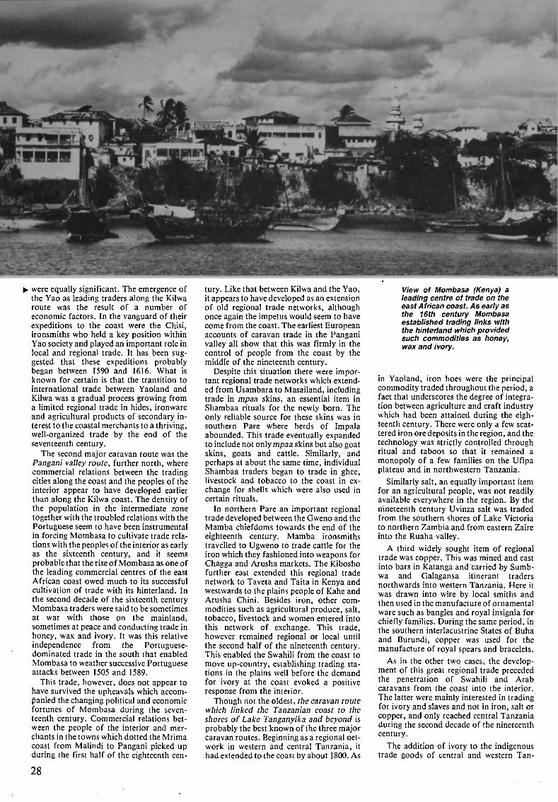
HM
were equally significant. The emergence of
the Yao as leading traders along the Kilwa
route was the result of a number of
economic factors. In the vanguard of their
expeditions to the coast were the Chisi,
ironsmiths who held a key position within
Yao society and played an important role in
local and regional trade. It has been sug¬
gested that these expeditions probably
began between 1590 and 1616. What is
known for certain is that the transition to
international trade between Yaoland and
Kilwa was a gradual process growing from
a limited regional trade in hides, ironware
and agricultural products of secondary in¬
terest to the coastal merchants to a thriving,
well-organized trade by the end of the
seventeenth century.
The second major caravan route was the
Pangani valley route, further north, where
commercial relations between the trading
cities along the coast and the peoples of the
interior appear to have developed earlier
than along the Kilwa coast. The density of
the population in the intermediate zone
together with the troubled relations with the
Portuguese seem to have been instrumental
in forcing Mombasa to cultivate trade rela¬
tions with the peoples of the interior as early
as the sixteenth century, and it seems
probable that the rise of Mombasa as one of
the leading commercial centres of the east
African coast owed much to its successful
cultivation of trade with its hinterland. In
the second decade of the sixteenth century
Mombasa traders were said to be sometimes
at war with those on the mainland,
sometimes at peace and conducting trade in
honey, wax and ivory. It was this relative
independence from the Portuguese-
dominated trade in the south that enabled
Mombasa to weather successive Portuguese
attacks between 1505 and 1589.
This trade, however, does not appear to
have survived the upheavals which accom¬
panied the changing political and economic
fortunes of Mombasa during the seven¬
teenth century. Commercial relations bet¬
ween the people of the interior and mer¬
chants in the towns which dotted the Mrima
coast from Malindi to Pangani picked up
during the first half of the eighteenth cen-
28
tury. Like that between Kilwa and the Yao,
it appears to have developed as an extension
of old regional trade networks, although
once again the impetus would seem to have
come from the coast. The earliest European
accounts of caravan trade in the Pangani
valley all show that this was firmly in the
control of people from the coast by the
middle of the nineteenth century.
Despite this situation there were impor¬
tant regional trade networks which extend¬
ed from Usambara to Masailand, including
trade in mpaa skins, an essential item in
Shambaa rituals for the newly born. The
only reliable source for these skins was in
southern Pare where herds of Impala
abounded. This trade eventually expanded
to include not only mpaa skins but also goat
skins, goats and cattle. Similarly, and
perhaps at about the same time, individual
Shambaa traders began to trade in ghee,
livestock and tobacco to the coast in ex¬
change for shells which were also used in
certain rituals.
In northern Pare an important regional
trade developed between the Gweno and the
Mamba chiefdoms towards the end of the
eighteenth century. Mamba ironsmiths
travelled to Ugweno to trade cattle for the
iron which they fashioned into weapons for
Chagga and Arusha markets. The Kibosho
further east extended this regional trade
network to Taveta and Taita in Kenya and
westwards to the plains people of Kahe and
Arusha Chini. Besides iron, other com¬
modities such as agricultural produce, salt,
tobacco, livestock and women entered into
this network of exchange. This trade,
however remained regional or local until
the second half of the nineteenth century.
This enabled the Swahili from the coast to
move up-country, establishing trading sta¬
tions in the plains well before the demand
for ivory at the coast evoked a positive
response from the interior.
Though not the oldest, the caravan route
which linked the Tanzanian coast to the
shores of Lake Tanganyika and beyond is
probably the best known of the three major
caravan routes. Beginning as a regional net¬
work in western and central Tanzania, it
had extended to the coast by about 1 800. As
View of Mombasa (Kenya) a
leading centre of trade on the
east African coast. As early as
the 16th century Mombasa
established trading links with
the hinterland which provided
such commodities as honey,
wax and ivory.
in Yaoland, iron hoes were the principal
commodity traded throughout the period, a
fact that underscores the degree of integra¬
tion between agriculture and craft industry
which had been attained during the eigh¬
teenth century. There were only a few scat¬
tered iron ore deposits in the region, and the
technology was strictly controlled through
ritual and taboos so that it remained a
monopoly of a few families on the Ufipa
plateau and in northwestern Tanzania.
Similarly salt, an equally important item
for an agricultural people, was not readily
available everywhere in the region. By the
nineteenth century Uvinza salt was traded
from the southern shores of Lake Victoria
to northern Zambia and from eastern Zaire
into the Ruaha valley.
A third widely sought item of regional
trade was copper. This was mined and cast
into bars in Katanga and carried by Sumb-
wa and Galagansa itinerant traders
northwards into western Tanzania. Here it
was drawn into wire by local smiths and
then used in the manufacture of ornamental
ware such as bangles and royal insignia for
chiefly families. During the same period, in
the southern interlacustrine States of Buha
and Burundi, copper was used for the
manufacture of royal spears and bracelets.
As in the other two cases, the develop¬
ment of this great regional trade preceded
the penetration of Swahili and Arab
caravans from the coast into the interior.
The latter were mainly interested in trading
for ivory and slaves and not in iron, salt or
copper, and only reached central Tanzania
during the second decade of the nineteenth
century.
The addition of ivory to the indigenous
trade goods of central and western Tan-
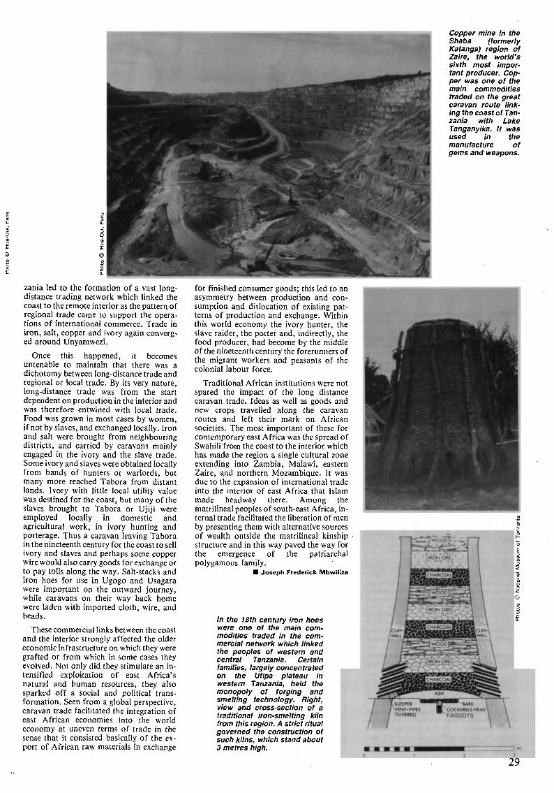
zania led to the formation of a vast long¬
distance trading network which linked the
coast to the remote interior as the pattern of
regional trade came to support the opera¬
tions of international commerce. Trade in
iron, salt, copper and ivory again converg¬
ed around Unyamwezi.
Once this happened, it becomes
untenable to maintain that there was a
dichotomy between long-distance trade and
regional or local trade. By its very nature,
long-distance trade was from the start
dependent on production in the interior and
was therefore entwined with local trade.
Food was grown in most cases by women,
if not by slaves, and exchanged locally. Iron
and salt were brought from neighbouring
districts, and carried by caravans mainly
engaged in the ivory and the slave trade.
Some ivory and slaves were obtained locally
from bands of hunters or warlords, but
many more reached Tabora from distant
lands. Ivory with little local utility value
was destined for the coast, but many of the
slaves brought to Tabora or Ujiji were
employed locally in domestic and
agricultural work, in ivory hunting and
porterage. Thus a caravan leaving Tabora
in the nineteenth century for the coast to sell
ivory and slaves and perhaps some copper
wire would also carry goods for exchange or
to pay tolls along the way. Salt-stacks and
iron hoes for use in Ugogo and Usagara
were important on the outward journey,
while caravans on their way back home
were laden with imported cloth, wire, and
beads.
These commercial links between the coast
and the interior strongly affected the older
economic infrastructure on which they were
grafted or from which in some cases they
evolved. Not only did they stimulate an in¬
tensified exploitation of east Africa's
natural and human resources, they also
sparked off a social and political trans¬
formation. Seen from a global perspective,
caravan trade facilitated the integration of
east African economies into the world
economy at uneven terms of trade in the
sense that it consisted basically of the ex¬
port of African raw materials in exchange
for finished consumer goods; this led to an
asymmetry between production and con¬
sumption and dislocation of existing pat¬
terns of production and exchange. Within
this world economy the ivory hunter, the
slave raider, the porter and, indirectly, the
food producer, had become by the middle
of the nineteenth century the forerunners of
the migrant workers and peasants of the
colonial labour force.
Traditional African institutions were not
spared the impact of the long distance
caravan trade. Ideas as well as goods and
new crops travelled along the caravan
routes and left their mark on African
societies. The most important of these for
contemporary east Africa was the spread of
Swahili from the coast to the interior which
has made the region a single cultural zone
extending into Zambia, Malawi, eastern
Zaire, and northern Mozambique. It was
due to the expansion of international trade
into the interior of east Africa that Islam
made headway there. Among the
matrilineal peoples of south-east Africa, in¬
ternal trade facilitated the liberation of men
by presenting them with alternative sources
of wealth outside the matrilineal kinship
structure and in this way paved the way for
the emergence of the patriarchal
polygamous family.
Joseph Frederick Mbwiliza
In the 18th century iron hoes
were one of the main com¬
modities traded in the com¬
mercial network which linked
the peoples of western and
central Tanzania. Certain
families, largely concentrated
on the Ufipa plateau in
western Tanzania, held the
monopoly of forging and
smelting technology. Right,
view and cross-section of a
traditional iron-smelting kiln
from this region. A strict ritual
governed the construction of
such kilns, which stand about
3 metres high.
Copper mine in the
Shaba (formerly
Katanga) region of
Zaire, the world's
sixth most impor¬
tant producer. Cop¬
per was one of the
main commodities
traded on the great
caravan route link¬
ing the coast of Tan¬
zania with Lake
Tanganyika. It was
used in the
manufacture of
gems and weapons.
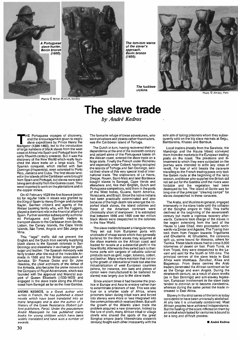
A Portuguese^
slave-hunter.l
| Benin bronze]m (1600).\
Photos © British Museum, London
The tom-tom warns
of the slaver's
approach.
Benin bronze
(1600).
The luckless
victims.Photo © Almasy, Paris
The slave tradeby André Redros
THE Portuguese voyages of discovery,
and the encouragement given to negro
slave expeditions by Prince Henry the
Navigator (1394-1460), led to the introduction
of large numbers of black slaves from the west
coast of Africa into Spain and Portugal from the
early fifteenth century onwards. But it was the
discovery of the New World which really laun¬
ched the slave trade on a large scale. The
Spanish conquest, which started with San
Domingo (Hispaniola), soon extended to Porto
Rico, Jamaica and Cuba. The first slaves land¬
ed in the islands of the Caribbean were brought
from Spain and Portugal, but slaves were soon
being sent directly from the Guinea coast. They
were imported to work on the plantations and in
the copper mines.
On 12 February 1528 the first licence {asien¬
to) for regular trade in slaves was granted by
the King of Spain to Henry Ehinger and Jerome
Sayler, German citizens and agents of the
Weiser banking family who, with the Fuggers,
played a dominant role in the financial affairs of
Spain. Further asientos subsequently authoriz¬
ed Portuguese and Spanish traders to
transport slaves to the Caribbean from Seville,
Lisbon, the Canary Islands, the Cape Verde
Islands, Sao Tomé, Angola and Säo Jorge de
Mina.
This "legal" traffic did not prevent the
English and the Dutch from secretly supplying
black slaves to the Spanish colonists in San
Domingo and elsewhere in exchange for gold,
sugar and leather. The Spanish monopoly was
fairly broken after the rout of the Invincible Ar¬
mada in 1588 and the British occupation of
Jamaica. Sir Francis Drake and Sir John
Hawkins, the chief architects of the defeat of
the Armada, also became the prime movers in
the Company of Royal Adventurers, which was
founded with the approval and financial sup¬
port of Queen Elizabeth (1533-1603) and
engaged in the slave trade along the African
coast from Senegal as far as the river Gambia.
ANDRE KEDROS, is a Greek author who
writes in French. He has published a dozen
novels which have been translated into as
many languages and is also the author of a
History of the Greek Resistance (Robert Laf-
font publishers, Paris). Under the pseudonym
André Massepain he has published many
books for young children which have been
widely translated and have won a number of
awards.
30
The favourite refuge of these adventurers, who
were privateers and pirates rather than traders,
was the Caribbean island of Tortuga.
The Dutch in turn, having recovered their in¬
dependence at the end of the sixteenth century
and seized some of the Portuguese bases on
the African coast, entered the slave trade on a
large scale. Finally the French under Richelieu
and especially under Colbert, having occupied
the islands of Tortuga and San Domingo, seiz¬
ed their share of this very special kind of inter¬
national trade. The shipowners of Le Havre,
Dieppe, Rouen, Saint-Malo and later Bordeaux
bought slaves in Senegal, Cape Verde and
elsewhere and, like their English, Dutch and
Portuguese competitors, sold them in the ports
of the West Indies, Guiana, North America,
Venezuela, and Brazil. Since the native Indians
had been practically exterminated and also
because of the high death rate amongst the im¬
ported black slaves, the island colonies and
those of the American continent were
chronically short of manpower. It is estimated
that between 1666 and 1800 over ten million
black slaves were despatched to the colonies
in the New World.
The slave-traders followed a triangular route.
They set out from European ports with
shiploads of cheap wares which they generally
bartered for the black slaves they acquired at
the slave markets on the African coast and
loaded for re-sale at a substantial profit in the
New World. Afterwards they sailed back to their
home ports with cargoes of valuable colonial
products such as gold, sugar, tobacco, cotton,
and leather. Many writers maintain that not on¬
ly the growth of international trade but also the
industrialization of west European countries
(where, for instance, iron bars and pieces of
cotton were manufactured to be bartered for
slaves) was largely due to the slave trade.
Since ancient times it had become the prac¬
tice in Europe and Asia to enslave rather than
to exterminate prisoners of war. This was also
true on a smaller scale of Africa, where
prisoners taken during tribal wars and forced
into slavery were more or less integrated into
the communities which received them. But with
the growth of the Atlantic slave trade the
problem acquired a new dimension. Incited by
the lure of profit, many African tribal or village
chiefs who shared the spoils of the great
Songhai empire (early fifteenth-late sixteenth
century) fought each other incessantly with the
sole aim of taking prisoners whom they subse¬
quently sold on the big slave markets at Segu,
Bambarena, Khasso and Bambuk.
Local traders (mostly from the Sarakole, the
Mandingo and the Hausa tribes) conveyed
them from the markets to the European trading
posts on the coast. The privations and ill-
treatment to which they were subjected on the
journey were intended to stifle any ideas of
revolt. For fear of wild beasts the caravans
travelling to the French trading posts only took
the Galam route at the beginning of the rainy
season, and those who supplied the British did
not set out for the Gambia until the rivers were
fordable and the vegetation had been
destroyed by fire. The island of Gorée was for
long one of the principal "clearing camps" for
slaves despatched in these caravans.
The Arabs, and Muslims in general, engaged
intensively in the slave trade until the collapse
of the Songhai empire in 1592. This traffic
declined at the beginning of the seventeenth
century but made a vigorous recovery after¬
wards. Caravans took charge of the slaves in
the region extending from the land of the
Hausa to Lake Chad, then proceeded north¬
wards via Zinder and Agades. The Tuareg then
took them from Fezzan towards Tripolitania
and Ghudamis. At Ghudamis, the caravans
split up, some bound for Morocco, others for
Tunisia. These black slaves had to cross 3,000
kilometres of desert on foot. From Tunis, or
from Tripoli, they were despatched to the Le¬
vant and sold for the fourth or fifth time. The
principal centres of the slave trade in East
Africa were Mombasa, Zanzibar, Kilwa and
Bagamoyo. From these centres the Arab
traders penetrated the African continent as far
as the Congo and even Angola. During the
nineteenth century, as a result of slave revolts
(as in San Domingo) and anti-slavery legisla¬
tion, European involvement in the slave trade
tended to diminish or to become clandestine,
whereas during the same period the trade in¬
creased in East Africa.
Slavery in the strict sense of the term is today
considered to have been universally abolished.
At any rate it is universally condemned. Most
African peoples have achieved independence.
But the healing of the scars inflicted on them by
an ordeal which lasted for centuries is bound to
be a long and difficult process.
André Kedros

TWTDTl^srtíW^^^
A world athirst for oil
by Vincent Labouret
MOST of the oil discovered since the
early years of this century has
been found in countries where it
has been used only in small quantities,
whereas several major oil-consuming coun¬
tries have little or no oil on their own ter¬
ritory. Hence trade in oil has grown con¬
stantly until oil has become the most impor¬
tant internationally traded commodity in
terms of both volume and value. In 1982,
for example, energy products accounted for
one-quarter and oil for one-fifth, of a total
volume of trade in commodities amounting
in value to 1,850,000 million dollars.
The situation of oil is even more striking
when its transportation by sea is con¬
sidered. In 1980, oil or oil-based products
accounted for half of the 3,732 million
tonnes of cargo carried by the world's
ships. In fact the volume of petroleum pro¬
ducts carried by sea grew at the extremely
rapid rate of almost 10 per cent a year bet¬
ween 1950 and 1973 when, at its peak, it
represented 57 per cent of all sea-borne
commodities.
The importance of this trade is further
compounded by the very long distance that
oil tankers cover. The United States is
13,500 kilometres from the Gulf, southern
Europe 7,800 kilometres distant (via the
Suez Canal), and Rotterdam almost 20,000
kilometres away (via the Cape of Good
Hope). Tankers sailing from Venezuela and
unloading in Rotterdam have a voyage of
some 7,500 kilometres. Japan is 12,500
kilometres from Saudi Arabia.
VINCENT LABOURET, of France, is Secretary-
General of the French oil company Total. He
holds the rank of Minister Plenipotentiary.
The history of the "oil routes" is thus
linked to the technical means used from the
early days to ensure the increasingly
economic transportation of the precious
cargoes of crude oil over these long
distances in other words, to the growth of
the tanker fleet.
As early as 1870, only some ten years
after oil had been discovered at Titusville in
Pennsylvania, 64 per cent of America's pro¬
duction was already being exported. The
United States and Russia, which together
supplied more than nine-tenths of all the oil
extracted in the last quarter of the nine¬
teenth century, exported more than half
their output. The two countries engaged in
fierce competition on the European market
from 1883 onwards, after the inauguration
of the railway linking the Russian oilfields
to the Black Sea port of Batumi.
The first bulk exports of oil from the
United States to Europe were carried by
sailing ships on which tanks had been in¬
stalled. The first such vessel seems to have
been the Charles, which was built in 1869
and was fitted out with fifty-nine tanks
representing a capacity of 714 tonnes.
Owing to technical ballasting problems,
however, the bulk transportation of oil was
limited until 1875.
It was the need to keep the French refin¬
ing industry supplied that first occasioned
the bulk export of crude oil in 1874, when
such exports amounted to 300,000 barrels;
they had risen to 450,000 barrels by 1879.
By then the French refining companies had
already built a series of unloading and
storage facilities between Le Havre and
Rouen which were very large for that time.
In 1879, Norwegian ship-owners put four
vessels into service on the Philadelphia-Le
Havre run. Three of them were sailing ships
but the fourth, the Stat, was steam-
powered. The Siaf shared with the
2,748-tonne Belgian ship, the Vaderland,
built in 1872, the distinction of being the
first steamship to carry oil in bulk.
By 1 885, more than one thousand vessels,
almost all of them sailing ships, were plying
between the United States and Europe. At
the same time, the Glückauf, the first
tanker of modern design, in which the crude
oil was actually carried in the ship's hull,
was being built in a British shipyard.
The use of steamships for this purpose
had a big economic impact. Whereas sailing
ships could make three return voyages
across the Atlantic in a year, the new
tankers made up to seven. By the mid-1890s
virtually all America's oil exports were be¬
ing carried by steamship. The age of the
sailing ship had gone for ever.
The world's fleet of engine-driven oil
tankers continued to grow in the early years
of this century, keeping pace with world¬
wide crude oil production and the growth in
consumer demand. Motor vehicles had ap¬
peared on the scene by 1910, and supersed¬
ed the oil lamp as the main market for
petroleum products. Growth was rapid: it
had taken the oil industry thirty-six years up
to 1895 to produce its first thousand million
barrels, but it was only eight years later that
the second thousand million barrels had
been produced, and by 1920 the industry
was producing five hundred thousand
million barrels a year.
When World War I broke out, the in¬
dustrial world was so dependent on oil that
31
Charles (1869)
From square-rigger
Gluckauf (1885)
Azov (1892) Atlas (1902)
4 É I
Outfield (1906) Motricine (1914)
^ a prime objective of the military strategy of
the belligerents was to secure access to
sources of supply. The war created so great
a demand for oil in Europe that soon there
were not enough tankers to cater for it. The
precious fuel was accordingly transported
in conventional cargo boats, in many cases
in their ballast tanks or in the space between
the hold and the hull.
The world's tanker fleet was thus able to
grow in pace with demand, which quad¬
rupled between 1918 and 1939. This period
saw the decline of the United States as an oil
exporter and the rise of production in many
parts of the Middle East, Latin America,
and Asia. The oil industry became truly in¬
ternational, even though the United States
continued up to 1947 to produce more than
60 per cent of the world's crude oil, and to
control 60 per cent of the world's tanker
fleet.
From the 1950s, the tanker fleet grew at
a hectic pace, doubling in size between 1947
and 1957, again by 1966, and yet again by
32
1973. What is more, in the twenty years
after 1950, the world recorded an un¬
precedented rate of economic development,
with growth rates in the western nations
reaching as high as 5 per cent a year. During
the same period, world oil consumption
grew by 7.6 per cent a year, in other words
even faster than overall energy consump¬
tion, which tended to .parallel growth in
GDP.
As oil consumption increased, the United
States' share of world production declined,
falling from 61 per cent in 1942 to 16 per
cent in 1973. Indeed, from 1947 onwards,
the United States became a net importer, in
a bid to meet ever-increasing demand.
It was from this time that the structure of
the modern oil industry took shape: pro¬
duction centres were located far from the
consumer centres, refineries were situated
near to the markets for the processed end-
products, and a fleet of oil tankers provided
the link between the two.
The "supertanker" generation was soon
to emerge. The first vessels of this type,
gauging some 32,000 d.w.t.*, were limited
in size to the capacity imposed by the Suez
Canal, but when the Canal was closed for
five months in 1957 ship-owners raced to
build jumbo-size tankers to derive max¬
imum benefit from economies of scale on
the route from the Middle East to Europe
via the Cape of Good Hope. By 1960, the
70,000 d.w.t. "Suezmax" class of tankers
was emerging from the shipyards, soon to
be followed by the 100,000 d.w.t. class.
However, the lack of suitable çort facilities
and limited storage capacity at the
unloading points acted as a brake on this
trend.
The 1960s brought a drop in the real price
of oil and cut-throat competition between
* Dead weigh! tonnage (d.w.t.) is equivalent to the full
load a ship is capable of carrying, plus the tonnage re¬
quired for its own needs by way of fuel tanks, crew
facilities, and so on. Hence the actual tonnage that can
be transported is slightly less (93 to 97 per cent) than the
d.w.t.
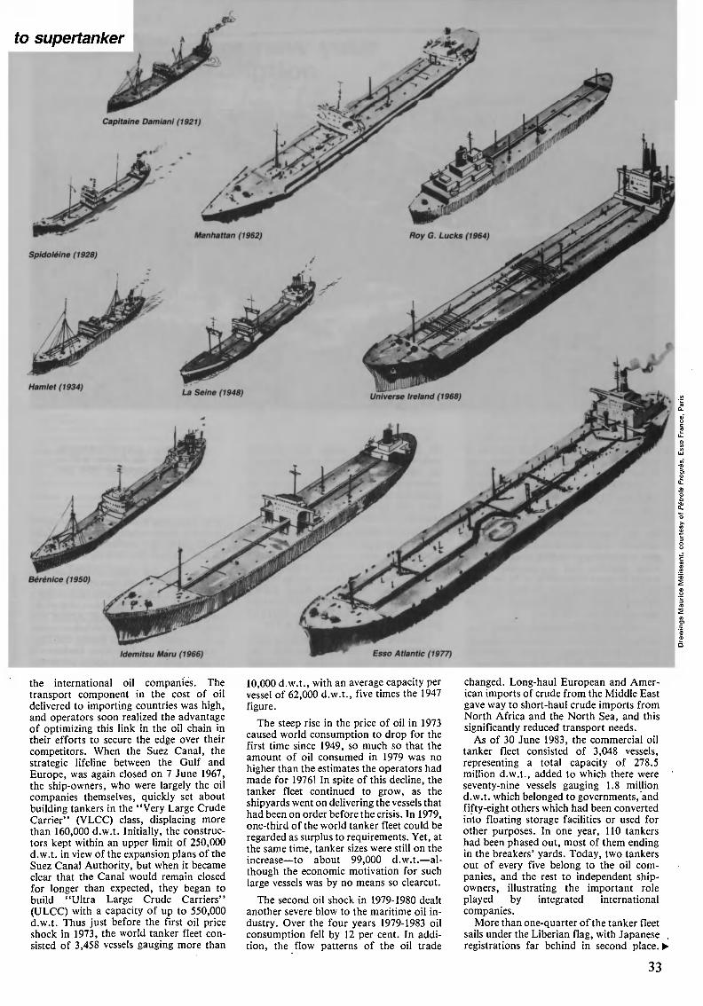
to supertanker
the international oil companies. The
transport component in the cost of oil
delivered to importing countries was high,
and operators soon realized the advantage
of optimizing this link in the oil chain in
their efforts to secure the edge over their
competitors. When the Suez Canal, the
strategic lifeline between the Gulf and
Europe, was again closed on 7 June 1967,
the ship-owners, who were largely the oil
companies themselves, quickly set about
building tankers in the "Very Large Crude
Carrier" (VLCC) class, displacing more
than 160,000 d.w.t. Initially, the construc¬
tors kept within an upper limit of 250,000
d.w.t. in view of the expansion plans of the
Suez Canal Authority, but when it became
clear that the Canal would remain closed
for longer than expected, they began to
build "Ultra Large Crude Carriers"
(ULCC) with a capacity of up to 550,000
d.w.t. Thus just before the first oil price
shock in 1973, the world tanker fleet con¬
sisted of 3,458 vessels gauging more than
10,000 d.w.t., with an average capacity per
vessel of 62,000 d.w.t., five times the 1947
figure.
The steep rise in the price of oil in 1973
caused world consumption to drop for the
first time since 1949, so much so that the
amount of oil consumed in 1979 was no
higher than the estimates the operators had
made for 1976! In spite of this decline, the
tanker fleet continued to grow, as the
shipyards went on delivering the vessels that
had been on order before the crisis. In 1979,
one-third of the world tanker fleet could be
regarded as surplus to requirements. Yet, at
the same time, tanker sizes were still on the
increaseto about 99,000 d.w.t.al¬
though the economic motivation for such
large vessels was by no means so clearcut.
The second oil shock in 1979-1980 dealt
another severe blow to the maritime oil in¬
dustry. Over the four years 1979-1983 oil
consumption fell by 12 per cent. In addi¬
tion, the flow patterns of the oil trade
changed. Long-haul European and Amer¬
ican imports of crude from the Middle East
gave way to short-haul crude imports from
North Africa and the North Sea, and this
significantly reduced transport needs.
As of 30 June 1983, the commercial oil
tanker fleet consisted of 3,048 vessels,
representing a total capacity of 278.5
million d.w.t., added to which there were
seventy-nine vessels gauging 1.8 million
d.w.t. which belonged to governments, and
fifty-eight others which had been converted
into floating storage facilities or used for
other purposes. In one year, 110 tankers
had been phased out, most of them ending
in the breakers' yards. Today, two tankers
out of every five belong to the oil com¬
panies, and the rest to independent ship¬
owners, illustrating the important role
played by integrated international
companies.
More than one-quarter of the tanker fleet
sails under the Liberian flag, with Japanese
registrations far behind in second place.
33
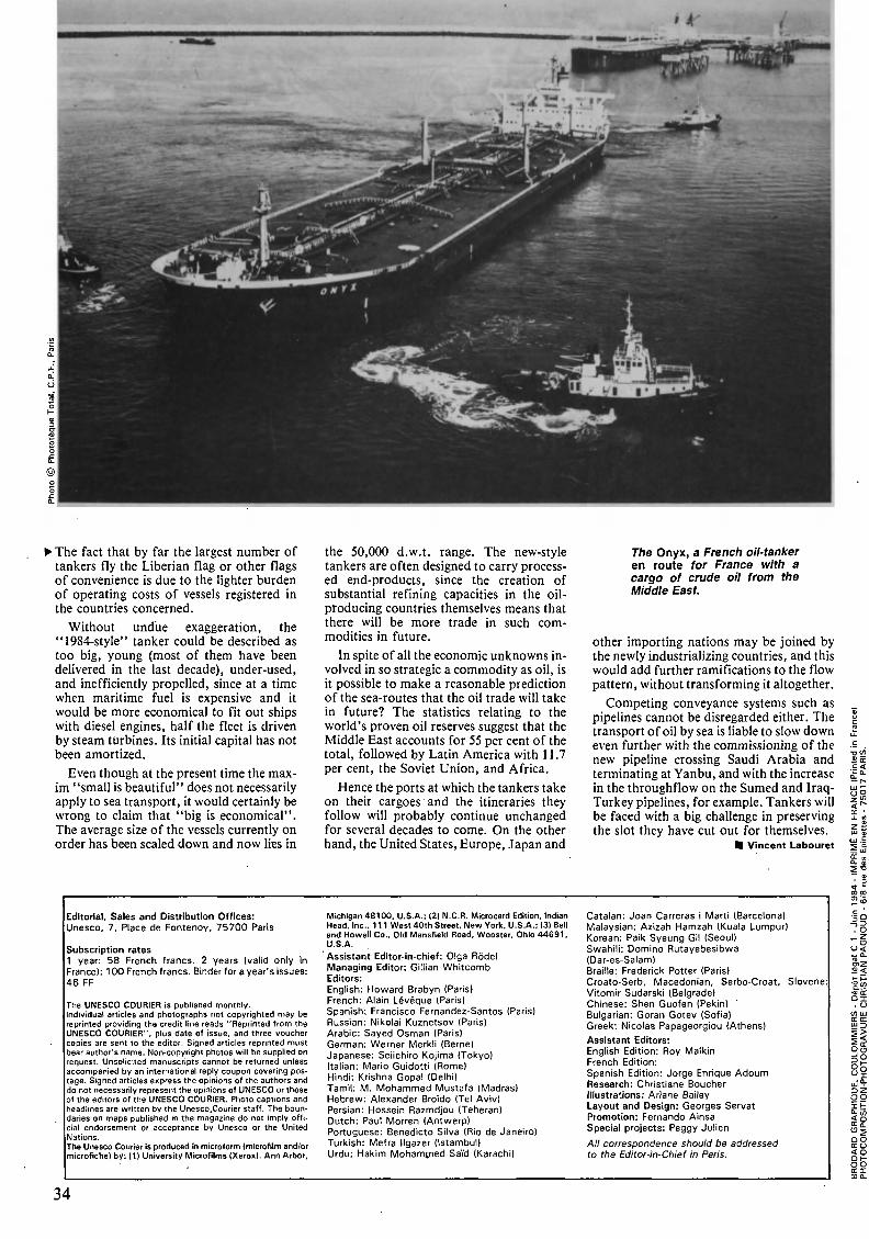
The fact that by far the largest number of
tankers fly the Liberian flag or other flags
of convenience is due to the lighter burden
of operating costs of vessels registered in
the countries concerned.
Without undue exaggeration, the
"1984-style" tanker could be described as
too big, young (most of them have been
delivered in the last decade), under-used,
and inefficiently propelled, since at a time
when maritime fuel is expensive and it
would be more economical to fit out ships
with diesel engines, half the fleet is driven
by steam turbines. Its initial capital has not
been amortized.
Even though at the present time the max¬
im "small is beautiful" does not necessarily
apply to sea transport, it would certainly be
wrong to claim that "big is economical".
The average size of the vessels currently on
order has been scaled down and now lies in
the 50,000 d.w.t. range. The new-style
tankers are often designed to carry process¬
ed end-products, since the creation of
substantial refining capacities in the oil-
producing countries themselves means that
there will be more trade in such com¬
modities in future.
In spite of all the economic unknowns in¬
volved in so strategic a commodity as oil, is
it possible to make a reasonable prediction
of the sea-routes that the oil trade will take
in future? The statistics relating to the
world's proven oil reserves suggest that the
Middle East accounts for 55 per cent of the
total, followed by Latin America with 1 1.7
per cent, the Soviet Union, and Africa.
Hence the ports at which the tankers take
on their cargoes and the itineraries they
follow will probably continue unchanged
for several decades to come. On the other
hand, the United States, Europe, Japan and
The Onyx, a French oil-tanker
en route for France with a
cargo of crude oil from the
Middle East.
other importing nations may be joined by
the newly industrializing countries, and this
would add further ramifications to the flow
pattern, without transforming it altogether.
Competing conveyance systems such as
pipelines cannot be disregarded either. The
transport of oil by sea is liable to slow down
even further with the commissioning of the
new pipeline crossing Saudi Arabia and
terminating at Yanbu, and with the increase
in the throughflow on the Sumed and Iraq-
Turkey pipelines, for example. Tankers will
be faced with a big challenge in preserving
the slot they have cut out for themselves.
Vincent Labouret
Editorial, Sales and Distribution Offices:
Unesco, 7, Place de Fontenoy, 75700 Paris
Subscription rates
1 year: 58 French francs. 2 years (valid only in
France): 1 00 French francs. Binder for a year's issues:
46 FF
The UNESCO COURIER is published monthly.
Individual articles and photographs not copyrighted may be
reprinted providing the credit line reads "Reprinted from the
UNESCO COURIER", plus date of issue, and three voucher
copies are sent to the editor. Signed articles reprinted must
bear author's name. Non-copyright photos will be supplied on
request. Unsolicited manuscripts cannot be returned unless
accompanied by an international reply coupon covering pos¬
tage. Signed articles express the opinions of the authors and
do not necessarily represent the opinions of UNESCO or those
of the editors of the UNESCO COURIER. Photo captions and
headlines are written by the Unesco.Courier staff. The boun¬
daries on maps published in the magazine do not imply offi¬
cial endorsement or acceptance by Unesco or the United
Nations.
The Unesco Courier is produced in microform (microfilm and/or
microfiche) by: (1) University Microfilms (Xerox). Ann Arbor,
Michigan 48100, U.S.A.: (2) N.C.R. Microcard Edition, Indian
Head. Inc.. 1 1 1 West 40th Street, New York. U.S.A.; 13) Bell
and Howell Co., Old Mansfield Road, Wooster, Ohio 44691,
U.S.A.
Assistant Editor-in-chief: Olga Rodel
Managing Editor: Gillian Whitcomb
Editors:
English: Howard Brabyn (Paris)
French: Alain Lévêque (Paris)
Spanish: Francisco Fernandez-Santos (Paris)
Russian: Nikolai Kuznetsov (Paris)
Arabic: Sayed Osman (Paris)
German: Werner Merkli (Berne)
Japanese: Seiichiro Kojima (Tokyo)
Italian: Mario Guidotti (Rome)
Hindi: Krishna Gopal (Delhi)
Tamil: M. Mohammed Mustafa (Madras)
Hebrew: Alexander Broîdo (Tel Aviv)
Persian: Hossein Razmdjou (Teheran)
Dutch: Paul Morren (Antwerp)
Portuguese: Benedicto Silva (Rio de Janeiro)
Turkish: Mefra llgazer (Istambul)
Urdu: Hakim Mohammed Sai'd (Karachi)
Catalan: Joan Carreras i Marti (Barcelona)
Malaysian: Azizah Hamzah (Kuala Lumpur)
Korean: Paik Syeung-Gil (Seoull
Swahili: Domino Rutayebesibwa
(Dar-es-Salam)
Braille: Frederick Potter (Paris)
Croato-Serb, Macedonian, Serbo-Croat, Slovene
Vitomir Sudarski (Belgrade)
Chinese: Shen Guofen (Pekin)
Bulgarian: Goran Gotev (Sofia)
Greek: Nicolas Papageorgiou (Athens)
Assistant Editors:
English Edition: Roy Malkin
French Edition:
Spanish Edition: Jorge Enrique Adoum
Research: Christiane Boucher
Illustrations: Ariane Bailey
Layout and Design: Georges Servat
Promotion: Fernando Ainsa
Special projects: Peggy Julien
All correspondence should be addressed
to the Editor-in-Chief in Paris.
34
Where to renew your
subscription
and place your order for other Unesco publications
Order from any bookseller
or write direct to the National Distributor in your country.
(See list below; names of distributors
in countries not listed, along with subscription rates
in local currency, will be supplied on request.)
AUSTRALIA. Hunter Publications, 58A Gipps Street, Collmg-
wood Victoria 3066; Publications: Educational Supplies Pty. Ltd.
P.O. Box 33, Brookvale, 2100, NSW. Periodicals: Dominie Pty.
Subscriptions Dept-, P.O. Box 33, Brookvale 2100, NSW. Sub-
agent: United Nations Association of Australia, P.O. Box 1 75,
5th floor. Ana House, 28 Elizabeth Street, Melbourne Victoria
3000.
AUSTRIA. Buchhandlung Gerold and Co., Graben 31, A-1011,
Vienna.
BAHAMAS. Nassau Stationers Ltd., P.O. Box N-31 38, Nassau.
BANGLADESH. Bangladesh Books International Ltd., Ittefaq
Building, 1, R.K. Mission Rd., Hatkhola, Dacca 3.
BARBADOS. University of the West Indies Bookshop, Cave Hill
Campus, P.O. Box 64, Bridgetown.
BELGIUM. "Unesco Courier" Dutch edition only: N.V.
Handelmaatschappij Keesing. Keesinglaan 2-18, 2100 Deurne-
Antwerpen. French edition and general Unesco publications
agent: Jean de Lannoy, 202, avenue du Roi, 1060 Brussels, CCP
000-0070823-13.
BOTSWANA. Botswana Book Centre, P.O. Box 91, Gaborone.
BURMA. Trade Corporation No. 9, 550-552 Merchant Street,
Rangoon.
CANADA. Renouf Publishing Co. Ltd., 2182 St. Catherine Street
West, Montreal, Que. H3H 1M7.
.CHAD. Librairie Abssounout, 24 av. Charles de Gaulle, B.P. 388,
N'Djamena. '
CHINA. China National Publications Import and Export
Corporation, P.O. Box 88, Beijing.
CYPRUS. "MAM", Archbishop Makarios 3rd Avenue, P.O. Box
1722, Nicosia.
CZECHOSLOVAKIA. - S.N.T.L, Spalena 51, Prague 1
(Permanent display); Zahranicni literatura, 1 1 Soukenicka, Prague
1 . For Slovakia only: Alfa Verlag. Publishers, Hurbanovo nam.
6,893 31 Bratislava - CSSR.
DENMARK. Munksgaard Export and Subscription Service, 35
Norre Sogade, DK 1370, Copenhagen K.
EGYPT (ARAB REPUBLIC OF). National Centre for Unesco
Publications, No. 1 Talaat Harb Street, Cairo.
ETHIOPIA. National Agency for Unesco, P.O. Box 2996, Addis
Ababa.
FINLAND. Akateeminen Kirjakauppa, Keskuskatu 1, SF-00100
Helsinki 10; Suomalainen Kirjakauppa Oy, Koivuvaarankuja 2,
01640 Vantaa 64.
FRANCE. Librairie de l'Unesco, 7, place de Fontenoy, 75700
Paris, CCP. 12598-48.
GABON. Librairie Hachette, B.P. 3923, Libreville.
GERMAN DEMOCRATIC REP. Buchhaus Leipzig. Postfach
140, 710 Leipzig or from Internationalen Buchhandlungen in the
G.D.R.
FED. REP. OF GERMANY. For the Unesco Courier (German,
English, French and Spanish editions): Mr. H. Baum, Deutscher
Unesco-Kurier Vertrieb, Basaltstrasse 57, D 5300 Bonn 3. For
other Unesco publications: Karger Verlag, Germering/Miinchen.
For scientific maps only: Geo Center, Postfach 800830,
Stuttgart 80.
GHANA. Presbyterian Bookshop Depot Ltd., P.O. Box 195,
Accra; Ghana Book Suppliers Ltd., P.O. Box 7869, Accra; The
University Bookshop of Ghana, Accra; The University Bookshop
of Cape Coast; The University Bookshop of Legon, P.O. Box 1 ,
Legon.
GREAT BRITAIN. See United Kingdom.
HONG KONG. Federal Publications IHK) Ltd., 5A Evergreen
Industrial Mansion, 12 Yip Fat Street; Aberdeen. Swindon Book
Co., 13-15, Lock Road, Kowloon. Hong Kong Government
Information Services, Publication Centre, Baskerville House, 22
Ice Street*.
HUNGARY. Akadémiai,Kónyvesbolt, Váci u. 22, Budapest V;
A.K.V. Konyvtúrosok Boltja, Népkóztársaság utja 16, Budapest
VI.
ICELAND. Snaebjorn Jonsson & Co., H.F., Hafnarstraeti 9,
Reykjavik.
INDIA. Orient Longman Ltd., Kamani Marg, Ballard Estate,
Bombay 400038; 17 Chittaranjan Avenue, Calcutta 13; 36a,
Anna Salai, Mount Road, Madras 2; 5-9-41/1 Bashir Bagh,
Hyderabad 500001 (AP); 80/1 Mahatma Gandhi Road, Banga-
lore-560001 ; 3-5-820 Hyderguda, Hyderabad-500001 . Sub-
Depots: Oxford Book & Stationery Co. 17 Park Street, Calcutta
70016; Scindia House, New Delhi; Publication Unit, Ministry of
Education and Culture, Ex. AFO Hutments, Dr. Rajendra Prasad
Road, New Delhi 110001.
INDONESIA. Bhratara Publishers and Booksellers. 29 Jl. Oto
Iskandardinata III, Jakarta; Indira P.T., Jl Dr Sam Ratulangie 37,
Jakarta Pusat.
IRAN. Kharazmie Publishing and Distribution Co., 28, Vessal
Shirazi Street, Enghélab Avenue. P.O. Box 314/1486, Teheran;
Iranian Nat. Comm, for Unesco. Seyed Jamal Eddin Assad Abadi
Avenue 64th Street, Bonyad Building P.O. Box 1533, Teheran.
IRAQ. McKenzie's Bookshop, AI Rashid Street, Baghdad.
IRELAND. The Educational Company of Ireland Ltd, Ballymount
Road, Walkinstown, Dublin 12; Tycooly International Publ. Ltd 6
Crofton Terrace, Dun Laoghaire Co., Dublin.
ISRAEL. A. B.C. Bookstore Ltd., P.O. Box 1 283, 71 AHenby
Road, Tel Aviv 61000.
ITALY. Licosa (Librería Commissionaria Sansoni, S.p.A.) Via
Lamarmora 45, Casella Postale 552, 50121 Florence.
JAMAICA. Sangster's Book Stores Ltd., P.O. Box 366, 101
Water Lane, Kingston. University of the West Indies Bookshop,
Mona, Kingston,
JAPAN. Eastern Book Service Inc., 37-3 Hongo 3-chome
Bunkyo-ku Tokyo 1 13.
KENYA. East African Publishing House, P.O. Box 30571 ,
Nairobi.
KOREA. Korean National Commission for Unesco, P.O. Box
Central 64, Seoul.
KUWAIT. The Kuwait Bookshop Co., Ltd, POB 2942, Kuwait;
for the Unesco Courier; Farafalla Press Agency, P.O. Box SAFA
4541, Kuwait.
LESOTHO. Mazenod Book Centre, P.O. Mazenod. Lesotho,
Southern Africa.
LIBERIA. Code and Yancy Bookshops Ltd., P.O. Box 286,
Monrovia.
LIBYA. Agency for Development of Publication & Distribution,
P.O. Box 34-35, Tripoli.
LUXEMBOURG. Librairie Paul Brück, 22, Grande-Rue,
Luxembourg.
MALAWI. Malawi Book Service, Head Office, P.O. Box 30044
Chichiri, Blantyre 3.
MALAYSIA. University of Malaya Cooperative Bookshop, Kuala
Lumpur 22-11.
MALTA. Sapienzas, 26 Republic Street, Valletta.
MAURITIUS. Nalanda Company Ltd., 30, Bourbon Street, Port-
Louis.
MONACO. British Library, 30 bd. des Moulins, Monte-Carlo.
NEPAL. Sajha Prakashan Polchowk, Kathmandu,
NETHERLANDS. For periodicals only: D&N -Faxon B.V., P.O.
Box 197, 1000 AD Amsterdam; for publications only: KEESING
BOEKEN B. V., Postbus 1 1 1 8, 1 000 BC Amsterdam.
NETHERLANDS ANTILLES. Van Dorp-Eddine N.V., P.O. Box
200, Willemstad, Curaçao. N.A.
NEW ZEALAND. Government Printing Office, Government
Bookshops at: Rutland Street, P.O. Box 5344, Auckland; 130,
Oxford Terrace. P.O. Box 1 721 Christchurch; Alma Street, P.O.
Box 857 Hamilton; Princes Street, P.O. Box 1 104, Dunedm,
Mulgrave Street, Private Bag, Wellington.
NIGERIA. The University Bookshop of Ife; The University
Bookshop of Ibadan, P.O. 286; The University Bookshop of
Nsukka; The University Bookshop of Lagos; The Ahmadu Bello
University Bookshop of Zaria.
NORWAY. All publications: Johan Grundt Tanum (Booksellers),
Karl Johansgate 41/43, Oslo 1; Universitets Bokhandelen,
Universitetssentret, P.O.B. 307 Blindern, Oslo 3. For Unesco
Courier only: A.S. Narvesens Literaturjeneste, Box 6125, Oslo 6.
PAKISTAN. Mi'rza Book Agency, 65 Shahrah Quaid-i-azam, P.O.
Box No. 729, Lahore 3.
PHILIPPINES. The Modern Book Co., 926 Rizal Avenue, P.O.
Box 632, Manila D-404.
POLAND. Orpan-lmport, Palac Kultury 1 Nauki, Warsaw; Ars
Polona-Ruch, Krakowskie Przedmiescie No. 7.00-068 WARSAW.
PORTUGAL. Dias & Andrade Ltda. Livraria Portugal, rua do
Carmo 70, Lisbon.
SEYCHELLES. National Bookshop, P.O. Box 48. Mahé; New
Service Ltd., Kingsgate House, P.O. Box 131, Mahé.
SIERRA LEONE. Fourah Bay, Njala University and Sierra Leone
Diocesan Bookshops, Freetown.
SINGAPORE. Federal Publications (S) Pte Ltd. Times Jurong, 2
Jurong Port Road, Singapore 2261.
SOMALI DEMOCRATIC REPUBLIC. Modern Book Shop and
General, P.O. Box 951, Mogadiscio.
SOUTH AFRICA. For the Unesco Courier (single copies) only:
Central News agency, P.O. Box 1033, Johannesburg.
SRI LANKA. Lake House Bookshop, 100 Sir Ghittampalam
Gardiner Mawata P.O.B. 244 Colombo 2.
SUDAN. AI Bashir Bookshop, P.O. Box 1118, Khartoum.
SWEDEN. All publications A/B.C.E. Fritzes Kungl.
Hovbokhandel, Regeringsgatan 12, Box 16356. 10327
Stockholm 16. For the Unesco Courier: Svenska FN Förbundet,
Skolgrand 2, Box 1 50 50 S- 1 04 65, Stockholm.
SWITZERLAND. All publications: Europa Verlag. 5 Ramistrasse.
Zurich. Librairie Payot, rue Grenus 6, 1211, Geneva 1 1, CCP.
12-236. Librairies Payot also in Lausanne, Basle, Berne, Vevey,
Montreux, Neuchätel and Zurich.
TANZANIA. Dares Salaam Bookshop, P.O.B. 9030 Dar.-es-
Salaam.
THAILAND. Nibondh and Co. Ltd., 40-42 Charoen Krung Road,
Siyaeg Phaya Sri, P.O. Box 402; Bangkok: Suksapan Panit,
Mansion 9, Rajdamnern Avenue, Bangkok; Suksit Siam
Company, 1715 Rama IV Road, Bangkok.
TRINIDAD AND TOBAGO. National Commission for Unesco,
18 Alexandra Street, St. Clair, Trinidad, W.I.
TURKEY. Haset Kitapevi A.S., Istiklàl Caddesi, N° 469, Posta
Kutusu 219, Beyoglu, Istambul.
UGANDA. Uganda Bookshop, P.O. Box 7145, Kampala.
UNITED KINGDOM. H.M. Stationery Office, H.M. S.O., P.O.
Box 276, London, SW8 5DT, and Govt. Bookshops in London.
Edinburgh, Belfast, Manchester, Birmingham, Bristol; for
scientific maps only: McCarta Ltd., 1 22 King's Cross Road,
London WC 1X 9 DS.
UNITED STATES. Unipub, 205 East 42nd Street, New York,
N.Y. 1 001 7. Orders for books & Periodicals: Box 433, Murray
Hill Station, New York, N.Y. 10157,
U.S.S.R. Mezhdunarodnaya Kniga, Moscow, G-200,
YUGOSLAVIA. Mladost, Mica 30/1 1, Zagreb; Cankarjeva
Zalozba, Zopitarjeva 2, Lubljana; Nolit, Terazije 27/1 1, Belgrade.
ZAMBIA. National Educational Distribution Co. of Zambia Ltd.,
P.O. Box 2664 Lusaka.
ZIMBABWE. Textbook Sales (PVT) Ltd., 67 Union Avenue,
Harare.
Seven
Unesco
international
quarterlies
EDUCATION
ProspectsQuarterly Review of Education
Case-studies, new ideas and articles
touching on planning, teaching and
management.
1 year : 68 French francs
Educational
Documentation and
Information
Bulletin of the International Bureau of
Education.
Bibliographic sources and relevant
literature. Quarterly.
1 year: 52 F
SCIENCE
Impactof Science on Society
iExamines the social consequences of scien¬
tific and technological developments and
change. Quarterly.
1 year: 68 F
Nature
and Resources
Assesses man's interaction with the en¬
vironment. Reviews books on ecology,
hydrology, geology. Quarterly.
1 year: 38 F
SOCIAL SCIENCES
AND CULTURE
International
Social Science
Journal (ISSJ)
An authoritative, interdisciplinary review
of current scholarship in the social sciences.
Quarterly.
1 year: 110 F
Museum
Surveys trends in museum planning, opera¬
tion and administration, for professionals.
Quarterly.
1 year: 110 F
LIBRARY SCIENCE
Copyright Bulletin
Documents new developments and legis¬
lation concerning international copyrights.
Quarterly.
1 year: 38 F
To order: contact the national distributor
for Unesco publications in your country or
write to the Unesco Press, Unesco, 7 Place
de Fontenoy, 75700 Paris, France.
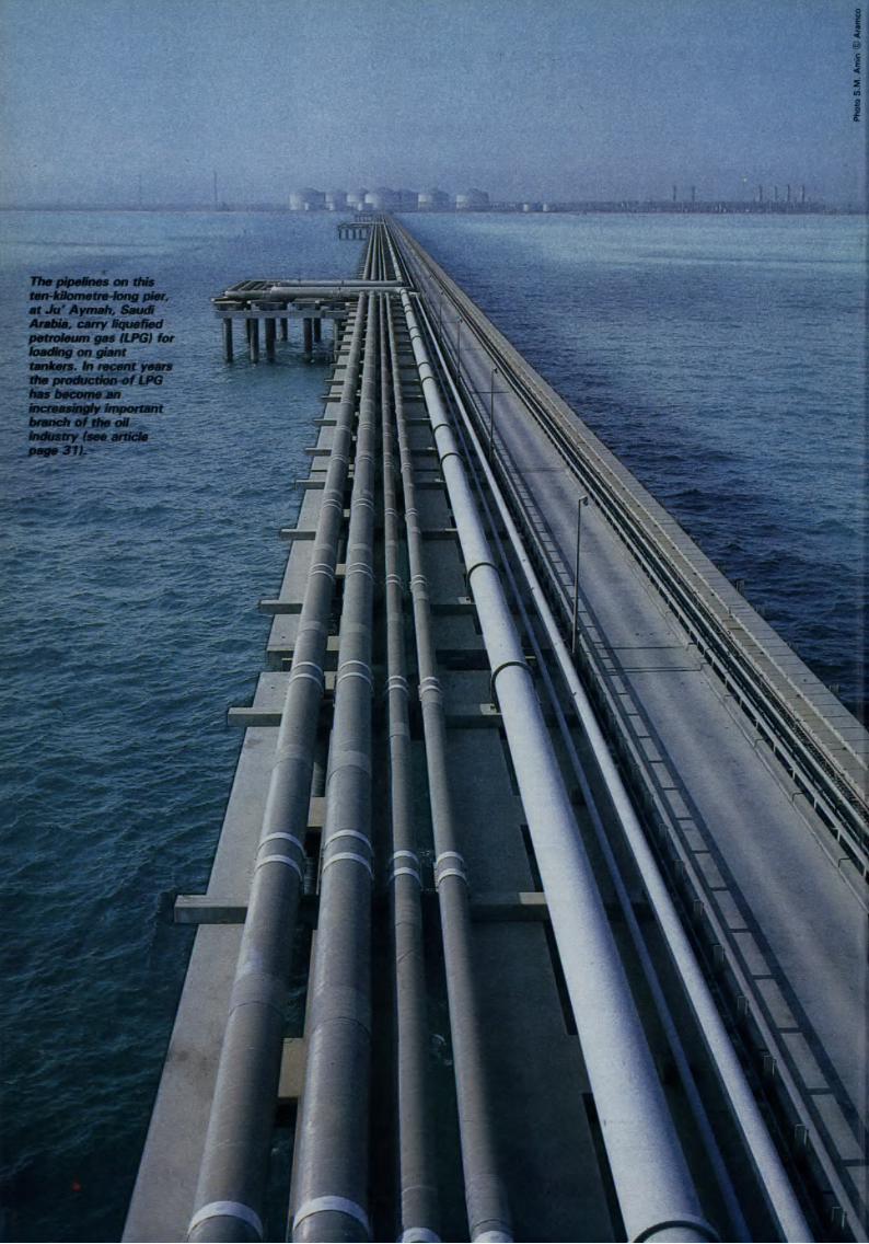
<
@c
Ë<
The pipelines on this
ten-kilometre-long pier,
at Ju' Aymah, Saudi
Arabia, carry liquefied
petroleum gas (LPG) for
loading on giant
tankers. In recent years
the production of LPG
has become an
increasingly important
branch of the oil
industry (see article
page 31).