Embed Size (px)
Citation preview
8/7/2019 Gravity survey of the Holocene Lake Tüttensee meteorite crater (Chiemgau impact event)
http://slidepdf.com/reader/full/gravity-survey-of-the-holocene-lake-tuettensee-meteorite-crater-chiemgau-impact 1/22
1
A gravity survey of the Holocene Lake Tüttensee meteorite impact crater(Chiemgau impact event).
Kord Ernstson (2011)
Universiy of Würzburg, Am Judengarten 23, 97204 Höchberg, Germany; [email protected]
________________________________________________________________
Abstract
The 600 m-diameter Lake Tüttensee structure is so far considered the largestmeteorite crater in the strewn field of the Holocene Chiemgau impact, althoughthere is strong evidence of a 900 m x 400 m rimmed doublet crater at the bottomof Lake Chiemsee. Shape and depth of the water body of Lake Tüttensee have beencontroversially disputed, which is probably related with the deposit of a layer of thick consolidated organic material. A gravity survey on the frozen lake and in itssurroundings had the principal aim to get knowledge of the crater shape. Themaximum gravity anomaly of Lake Tüttensee is about -0,8 milligals mainly resultingfrom the density contrast of water/organic material and rock. Modeling of thegravity anomaly with respect to the water (plus organic material) body, however,reveals unsatisfactory results related with a complex density distribution in thetarget rocks. Gravity also shows that the true crater is smaller than the lakeextent. Surprisingly, a ring of relatively positive anomalies is measured surrounding
the Tüttensee negative anomaly. The positive anomalies are modeled by a 1000 m-diameter flat lens of slightly enhanced density. It is explained by a model of soilliquefaction and post-liquefaction densification well known from largeearthquakes. Moreover, mass flow behind the impact shock front could havecontributed to the compaction of the unconsolidated, highly porous and water-saturated target rocks. In addition to impact melt rocks, shock metamorphism(PDFs), high pressure/short term deformations in rocks from the Tüttensee ringwall, and a catastrophic impact ejecta layer, the geophysical measurementsprovide a further argument against the hitherto favored origin of Lake Tüttenseefrom glacial dead-ice melting. Further studies of impact shock liquefaction may beinteresting for the understanding of impact cratering in targets composed of loose
and extremely water-rich rocks as has been discussed for near-surface sedimentson Mars.
1 Introduction
Within the frame of the Holocene Chiemgau impact event (CIRT 2004, Ernstson etal. 2010) the Lake Tüttensee near the town of Grabenstätt (Fig. 2) is a distinctissue. Located in the southwesterly end range of the impact strewn ellipse, it iscurrently considered the largest meteorite crater in the field exhibiting a rim-to-rim diameter of 600 m. However, detailed echo sounding measurements on LakeChiemsee have revealed a further (doublet) crater sized roughly 900 m x 400 m(Ernstson 2010, Rappenglück et al. 2010). The Lake Tüttensee crater that formed ina target of moraine and fluvio-glacial material has a distinct ring wall (Fig. 1), and
8/7/2019 Gravity survey of the Holocene Lake Tüttensee meteorite crater (Chiemgau impact event)
http://slidepdf.com/reader/full/gravity-survey-of-the-holocene-lake-tuettensee-meteorite-crater-chiemgau-impact 2/22
2
the impact nature is established by impact melt rocks (the pumice-like so-calledswim stones), shock metamorphism (e.g. PDFs in quartz; Schüssler et al. 2005),characteristic high-pressure/short term deformations, and an extended ejectalayer of polymictic breccias containing abundant organic matter like splinteredwood, charcoal, fractured animal bones and teeth (Ernstson et al. 2010).
Before the discovery of the Chiemgau impact Lake Tüttensee was generallyconsidered a relic from the Würm glacial period, a so-called dead-ice kettle. Thisinterpretation is still maintained by a few local and regional geologists (Doppler &Geiß 2005, Darga & Wierer 2009, Doppler et al. 2010), although the arguments haveclay feet (CIRT 2005, Ernstson et al. 2010, Rappenglück et al. 2011; also see thediscussion of the geologists' dead-ice speculations and lacking proofs by Martin[2007]).
A hitherto unsettled quantity was the depth of the Tüttensee kettle. While officialdata sheets mention 14 m on average and 17 m maximum water depth (meanwhile
confirmed by a sediment echosounder survey [Daut 2008]), divers have allegedlyplumbed about 70 m. Since Lake Tüttensee carries plenty of organic material and,according to divers reports, numerous tree trunks, inconsistent statements aboutthe depth are plausible. In fact, this organic material hampers information aboutthe deeper structure, which understandably is important for considerations aboutthe impact cratering process of the Lake Tüttensee crater. Thus, the idea came upto get an estimate of the crater depth by the aid of a gravity survey.
Gravity reacts on underground density contrasts, and hence the large densitycontrast between the lake water (the low-density organic material included) and
the embedding rock was the basis to "see" the crater in the gravity field and toenable a computer modeling of the crater shape. Instruments for themeasurements of gravity are highly sensitive gravimeters that can work only on asolid underground. Therefore, a measuring campaign on a frozen, walk-on-ableLake Tüttensee was a prerequisite.
Normally, gravity surveys are a prominent tool in the geophysical investigation of impact structures, because the extreme kinetic energy of the impacting projectiletransferred to the target may lead to enormous density changes within a largeunderground volume. Consequently, impact structures are in general featuringdistinct gravity anomalies, which are in many cases roughly circular.
However, in the case of small meteorite craters the respective effects are alsosmall, and for the Lake Tüttensee crater a gravity signature was though to be atthe limit of detectable effects especially with regard to the strong negative gravityanomaly of the lake water body.
The present article (which is a reworking of a former version in German [Ernstson2005]) reports on the gravity survey on the frozen Lake Tüttensee and in itsenvirons. It outlines the many steps of the data processing and shows computedmodels of the underground density distribution, which are interpreted in terms of the formation of the Lake Tüttensee crater.
8/7/2019 Gravity survey of the Holocene Lake Tüttensee meteorite crater (Chiemgau impact event)
http://slidepdf.com/reader/full/gravity-survey-of-the-holocene-lake-tuettensee-meteorite-crater-chiemgau-impact 3/22
3
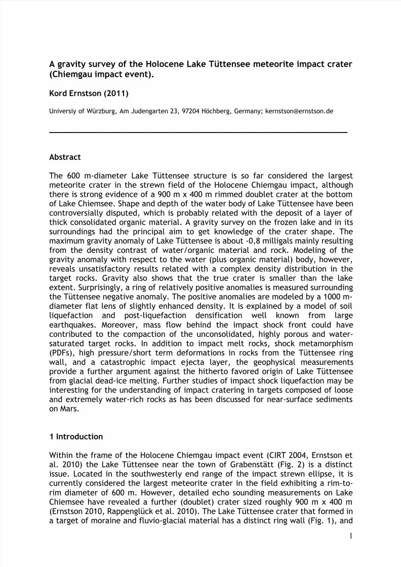
Fig. 1. Gravity measurements on the frozen Lake Tüttensee. In the background the ring wall of the crater.
2 Execution of the survey
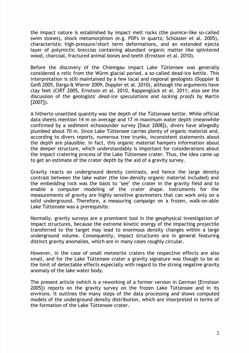
Fig. 2 shows the survey map with an outline of the measuring area. The surveycomprised 115 gravity stations, 40 of which were apportioned to the icy surface of Lake Tüttensee.
Fig. 2. Location map of the survey area.
8/7/2019 Gravity survey of the Holocene Lake Tüttensee meteorite crater (Chiemgau impact event)
http://slidepdf.com/reader/full/gravity-survey-of-the-holocene-lake-tuettensee-meteorite-crater-chiemgau-impact 4/22
4
A LaCoste-Romberg gravimeter, G type, was used. The temporal variations due toearth tides and instrument drift were recorded by repeated readings at a basestation. Since gravity readings sensitively depend on altitude, each gravity station,even those on ice, had precisely to be leveled. Recording topography for terrainreduction purposes had also to be performed, although the effects were in most
cases negligible.
3 Data processing and visualization
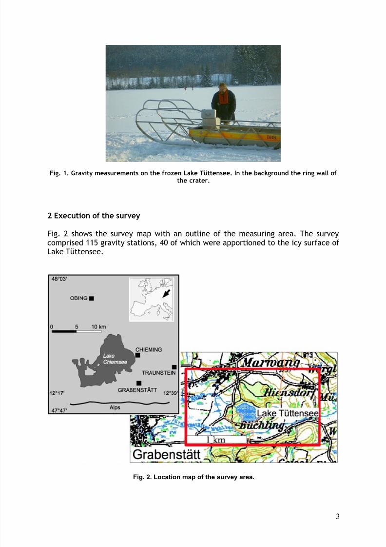
The standard corrections (Bouguer plate, free air, tidal, latitude, terrain) wereapplied to the data resulting in a map of Bouguer gravity anomalies (Fig. 3). Thescaling of the values around 20 mgals must not irritate because of the relativecharacter of the gravity data. A scaling in terms of existing gravity networks wasnot aimed at.
Fig. 3. Map of measured Bouguer anomalies. Triangles are gravity stations.
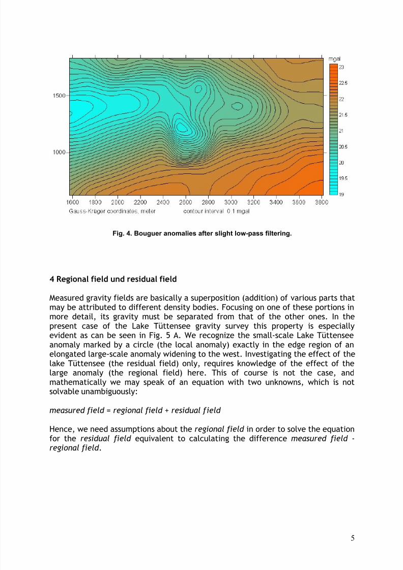
As with all fields of geophysical data, further processing may be useful, and gravityinterpretation may profit from various filter procedures. In the present case, theBouguer anomalies in a first step were subjected to a slight smoothing by low-passfiltering. The resulting field (Fig. 4). is the basis of all following processing stagesand related visualizations.
8/7/2019 Gravity survey of the Holocene Lake Tüttensee meteorite crater (Chiemgau impact event)
http://slidepdf.com/reader/full/gravity-survey-of-the-holocene-lake-tuettensee-meteorite-crater-chiemgau-impact 5/22
5
Fig. 4. Bouguer anomalies after slight low-pass filtering.
4 Regional field und residual field
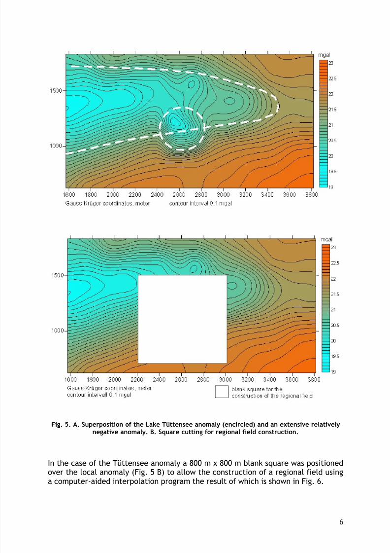
Measured gravity fields are basically a superposition (addition) of various parts thatmay be attributed to different density bodies. Focusing on one of these portions inmore detail, its gravity must be separated from that of the other ones. In thepresent case of the Lake Tüttensee gravity survey this property is especiallyevident as can be seen in Fig. 5 A. We recognize the small-scale Lake Tüttenseeanomaly marked by a circle (the local anomaly) exactly in the edge region of anelongated large-scale anomaly widening to the west. Investigating the effect of thelake Tüttensee (the residual field) only, requires knowledge of the effect of thelarge anomaly (the regional field) here. This of course is not the case, andmathematically we may speak of an equation with two unknowns, which is notsolvable unambiguously:
measured field = regional field + residual field
Hence, we need assumptions about the regional field in order to solve the equationfor the residual field equivalent to calculating the difference measured field -regional field .
8/7/2019 Gravity survey of the Holocene Lake Tüttensee meteorite crater (Chiemgau impact event)
http://slidepdf.com/reader/full/gravity-survey-of-the-holocene-lake-tuettensee-meteorite-crater-chiemgau-impact 6/22
6
Fig. 5. A. Superposition of the Lake Tüttensee anomaly (encircled) and an extensive relativelynegative anomaly. B. Square cutting for regional field construction.
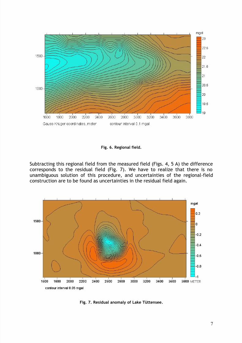
In the case of the Tüttensee anomaly a 800 m x 800 m blank square was positionedover the local anomaly (Fig. 5 B) to allow the construction of a regional field using
a computer-aided interpolation program the result of which is shown in Fig. 6.
8/7/2019 Gravity survey of the Holocene Lake Tüttensee meteorite crater (Chiemgau impact event)
http://slidepdf.com/reader/full/gravity-survey-of-the-holocene-lake-tuettensee-meteorite-crater-chiemgau-impact 7/22
7
Fig. 6. Regional field.
Subtracting this regional field from the measured field (Figs. 4, 5 A) the differencecorresponds to the residual field (Fig. 7). We have to realize that there is nounambiguous solution of this procedure, and uncertainties of the regional-field
construction are to be found as uncertainties in the residual field again.
Fig. 7. Residual anomaly of Lake Tüttensee.
8/7/2019 Gravity survey of the Holocene Lake Tüttensee meteorite crater (Chiemgau impact event)
http://slidepdf.com/reader/full/gravity-survey-of-the-holocene-lake-tuettensee-meteorite-crater-chiemgau-impact 8/22
8
5 Gradient fields
5.1 Horizontal gradient of the gravity field
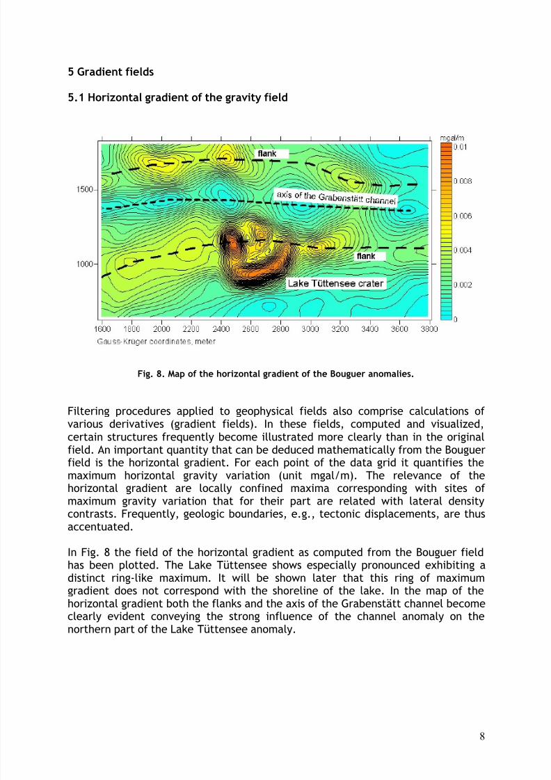
Fig. 8. Map of the horizontal gradient of the Bouguer anomalies.
Filtering procedures applied to geophysical fields also comprise calculations of various derivatives (gradient fields). In these fields, computed and visualized,certain structures frequently become illustrated more clearly than in the originalfield. An important quantity that can be deduced mathematically from the Bouguerfield is the horizontal gradient. For each point of the data grid it quantifies themaximum horizontal gravity variation (unit mgal/m). The relevance of thehorizontal gradient are locally confined maxima corresponding with sites of maximum gravity variation that for their part are related with lateral densitycontrasts. Frequently, geologic boundaries, e.g., tectonic displacements, are thusaccentuated.
In Fig. 8 the field of the horizontal gradient as computed from the Bouguer fieldhas been plotted. The Lake Tüttensee shows especially pronounced exhibiting adistinct ring-like maximum. It will be shown later that this ring of maximumgradient does not correspond with the shoreline of the lake. In the map of thehorizontal gradient both the flanks and the axis of the Grabenstätt channel becomeclearly evident conveying the strong influence of the channel anomaly on thenorthern part of the Lake Tüttensee anomaly.
8/7/2019 Gravity survey of the Holocene Lake Tüttensee meteorite crater (Chiemgau impact event)
http://slidepdf.com/reader/full/gravity-survey-of-the-holocene-lake-tuettensee-meteorite-crater-chiemgau-impact 9/22
9
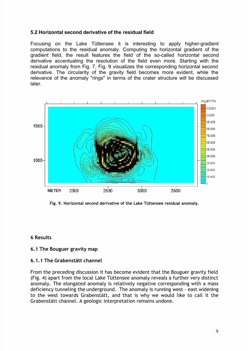
5.2 Horizontal second derivative of the residual field
Focusing on the Lake Tüttensee it is interesting to apply higher-gradientcomputations to the residual anomaly. Computing the horizontal gradient of thegradient field, the result features the field of the so-called horizontal second
derivative accentuating the resolution of the field even more. Starting with theresidual anomaly from Fig. 7, Fig. 9 visualizes the corresponding horizontal secondderivative. The circularity of the gravity field becomes more evident, while therelevance of the anomaly "rings" in terms of the crater structure will be discussedlater.
Fig. 9. Horizontal second derivative of the Lake Tüttensee residual anomaly.
6 Results
6.1 The Bouguer gravity map
6.1.1 The Grabenstätt channel
From the preceding discussion it has become evident that the Bouguer gravity field(Fig. 4) apart from the local Lake Tüttensee anomaly reveals a further very distinctanomaly. The elongated anomaly is relatively negative corresponding with a massdeficiency tunneling the underground. The anomaly is running west - east wideningto the west towards Grabenstätt, and that is why we would like to call it theGrabenstätt channel. A geologic interpretation remains undone.
8/7/2019 Gravity survey of the Holocene Lake Tüttensee meteorite crater (Chiemgau impact event)
http://slidepdf.com/reader/full/gravity-survey-of-the-holocene-lake-tuettensee-meteorite-crater-chiemgau-impact 10/22
10
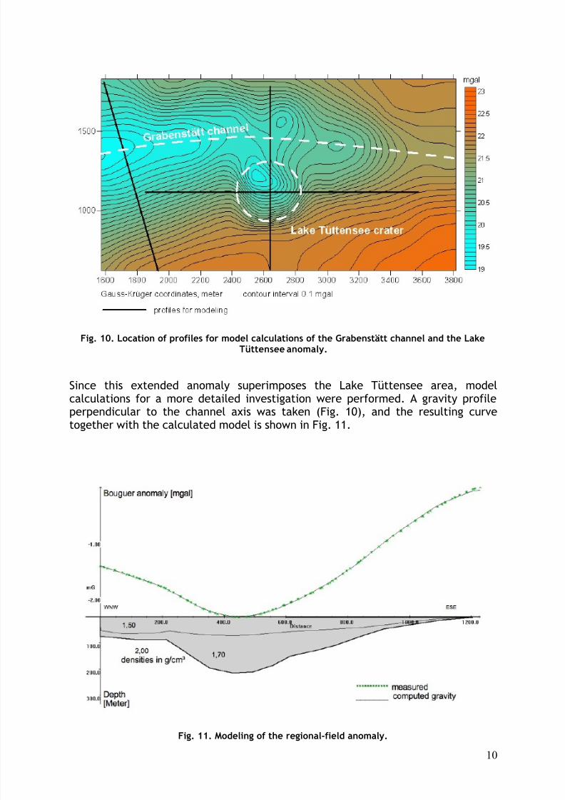
Fig. 10. Location of profiles for model calculations of the Grabenstätt channel and the LakeTüttensee anomaly.
Since this extended anomaly superimposes the Lake Tüttensee area, modelcalculations for a more detailed investigation were performed. A gravity profileperpendicular to the channel axis was taken (Fig. 10), and the resulting curvetogether with the calculated model is shown in Fig. 11.
Fig. 11. Modeling of the regional-field anomaly.
8/7/2019 Gravity survey of the Holocene Lake Tüttensee meteorite crater (Chiemgau impact event)
http://slidepdf.com/reader/full/gravity-survey-of-the-holocene-lake-tuettensee-meteorite-crater-chiemgau-impact 11/22
11
Measured and computed gravity fit well corresponding with an up to 200 m thickcausative body of considerably reduced density at the western edge of the surveyarea. The body itself is subdivided in an upper layer (density 1.5 g/cm3) and abottom layer (density 1.7 g/cm3) deepened into a host rock of density 2.0 g/cm3.
The calculation has featured a possible model; somewhat differing bodycoordinates and densities may also apply, but it is important to note the very lowdensities of the channel material playing a certain role when the Lake Tüttenseeanomaly is discussed.
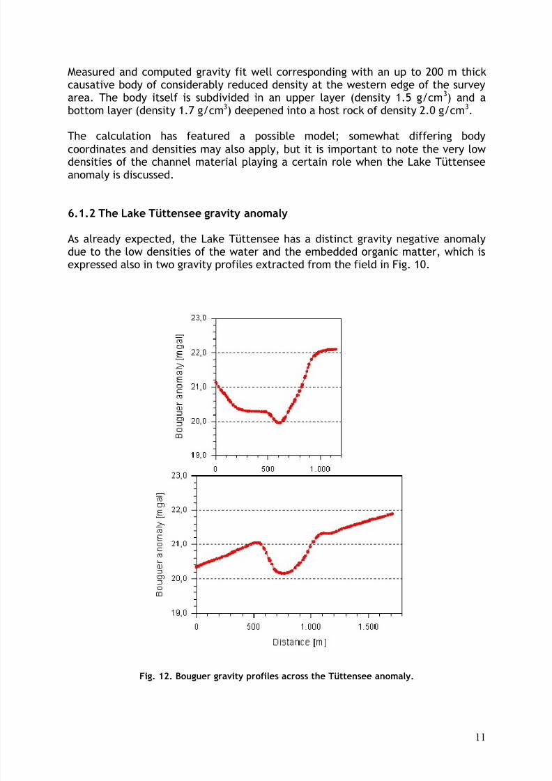
6.1.2 The Lake Tüttensee gravity anomaly
As already expected, the Lake Tüttensee has a distinct gravity negative anomalydue to the low densities of the water and the embedded organic matter, which isexpressed also in two gravity profiles extracted from the field in Fig. 10.
Fig. 12. Bouguer gravity profiles across the Tüttensee anomaly.
8/7/2019 Gravity survey of the Holocene Lake Tüttensee meteorite crater (Chiemgau impact event)
http://slidepdf.com/reader/full/gravity-survey-of-the-holocene-lake-tuettensee-meteorite-crater-chiemgau-impact 12/22
12
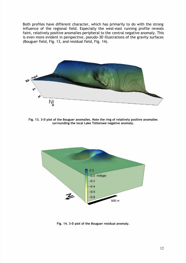
Both profiles have different character, which has primarily to do with the stronginfluence of the regional field. Especially the west-east running profile revealsfaint, relatively positive anomalies peripheral to the central negative anomaly. Thisis even more evident in perspective, pseudo-3D illustrations of the gravity surfaces(Bouguer field, Fig. 13, and residual field, Fig. 14).
Fig. 13. 3-D plot of the Bouguer anomalies. Note the ring of relatively positive anomaliessurrounding the local Lake Tüttensee negative anomaly.
Fig. 14. 3-D plot of the Bouguer residual anomaly.
8/7/2019 Gravity survey of the Holocene Lake Tüttensee meteorite crater (Chiemgau impact event)
http://slidepdf.com/reader/full/gravity-survey-of-the-holocene-lake-tuettensee-meteorite-crater-chiemgau-impact 13/22
13
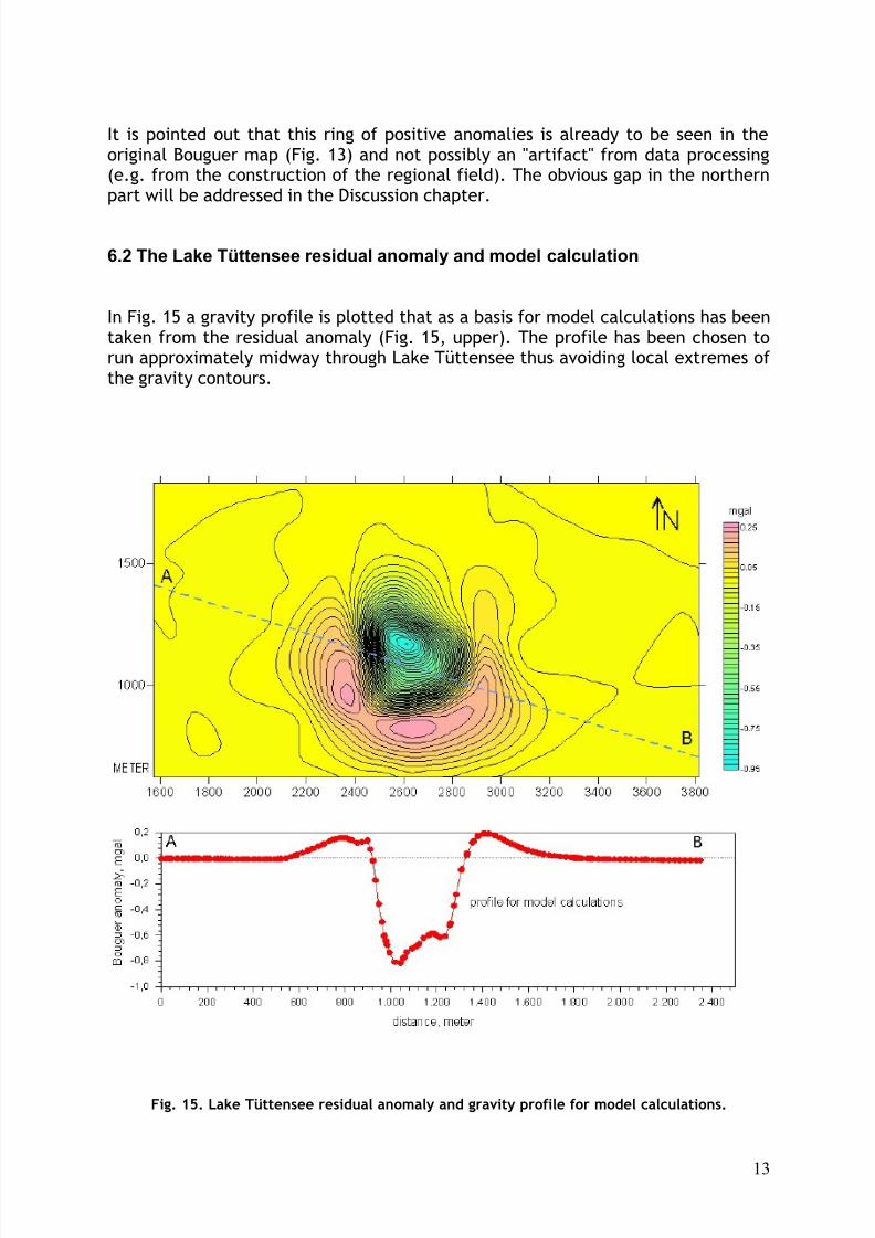
It is pointed out that this ring of positive anomalies is already to be seen in theoriginal Bouguer map (Fig. 13) and not possibly an "artifact" from data processing(e.g. from the construction of the regional field). The obvious gap in the northernpart will be addressed in the Discussion chapter.
6.2 The Lake Tüttensee residual anomaly and model calculation
In Fig. 15 a gravity profile is plotted that as a basis for model calculations has beentaken from the residual anomaly (Fig. 15, upper). The profile has been chosen torun approximately midway through Lake Tüttensee thus avoiding local extremes of the gravity contours.
Fig. 15. Lake Tüttensee residual anomaly and gravity profile for model calculations.
8/7/2019 Gravity survey of the Holocene Lake Tüttensee meteorite crater (Chiemgau impact event)
http://slidepdf.com/reader/full/gravity-survey-of-the-holocene-lake-tuettensee-meteorite-crater-chiemgau-impact 14/22
14
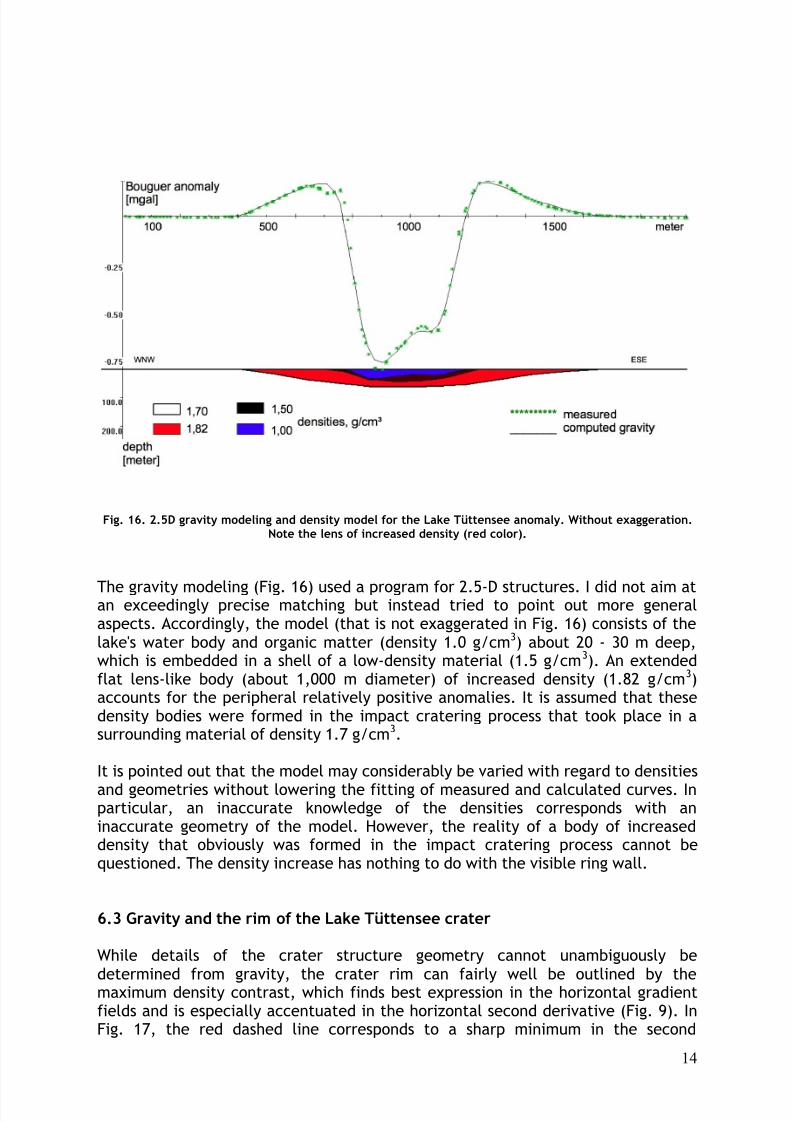
Fig. 16. 2.5D gravity modeling and density model for the Lake Tüttensee anomaly. Without exaggeration.Note the lens of increased density (red color).
The gravity modeling (Fig. 16) used a program for 2.5-D structures. I did not aim atan exceedingly precise matching but instead tried to point out more generalaspects. Accordingly, the model (that is not exaggerated in Fig. 16) consists of thelake's water body and organic matter (density 1.0 g/cm3) about 20 - 30 m deep,which is embedded in a shell of a low-density material (1.5 g/cm3). An extendedflat lens-like body (about 1,000 m diameter) of increased density (1.82 g/cm3)accounts for the peripheral relatively positive anomalies. It is assumed that thesedensity bodies were formed in the impact cratering process that took place in asurrounding material of density 1.7 g/cm3.
It is pointed out that the model may considerably be varied with regard to densities
and geometries without lowering the fitting of measured and calculated curves. Inparticular, an inaccurate knowledge of the densities corresponds with aninaccurate geometry of the model. However, the reality of a body of increaseddensity that obviously was formed in the impact cratering process cannot bequestioned. The density increase has nothing to do with the visible ring wall.
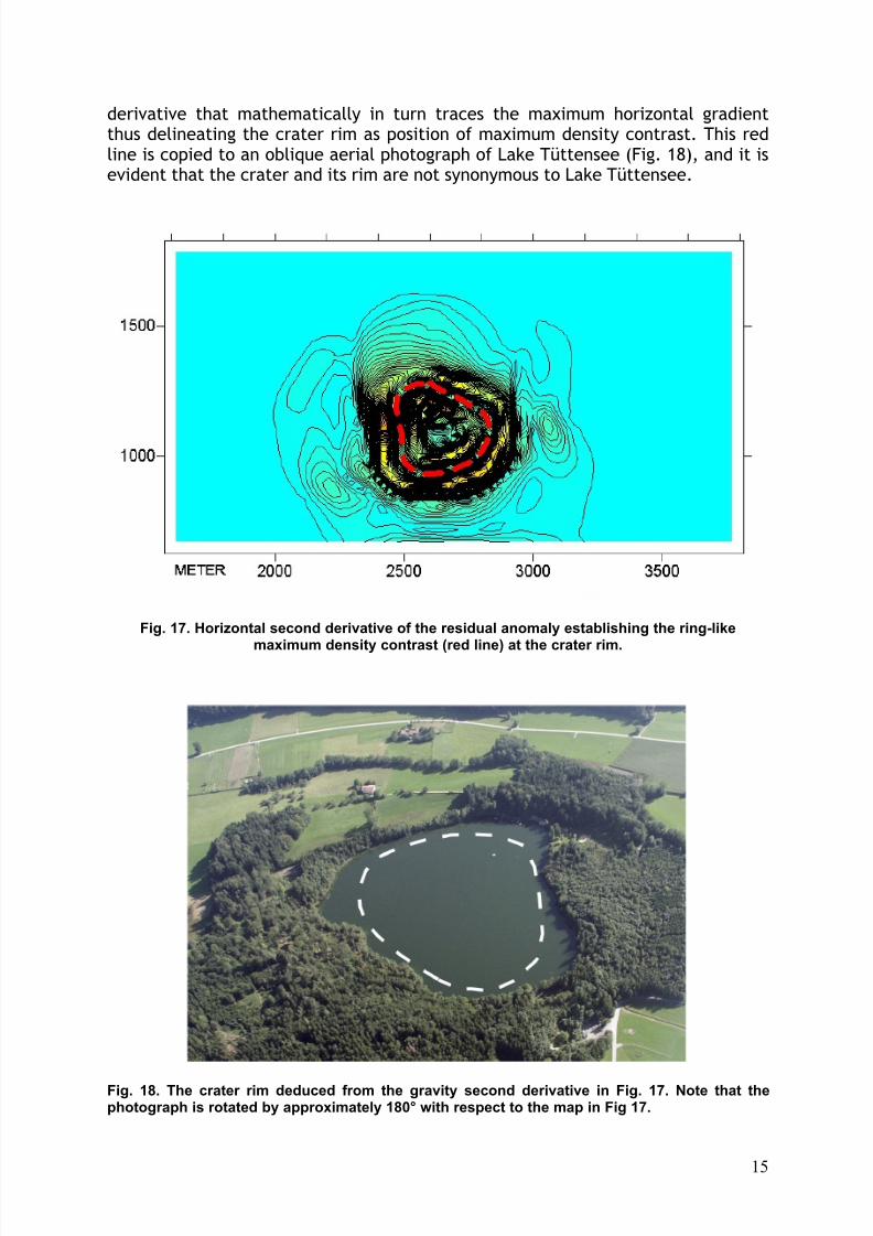
6.3 Gravity and the rim of the Lake Tüttensee crater
While details of the crater structure geometry cannot unambiguously be
determined from gravity, the crater rim can fairly well be outlined by themaximum density contrast, which finds best expression in the horizontal gradientfields and is especially accentuated in the horizontal second derivative (Fig. 9). InFig. 17, the red dashed line corresponds to a sharp minimum in the second
8/7/2019 Gravity survey of the Holocene Lake Tüttensee meteorite crater (Chiemgau impact event)
http://slidepdf.com/reader/full/gravity-survey-of-the-holocene-lake-tuettensee-meteorite-crater-chiemgau-impact 15/22
15
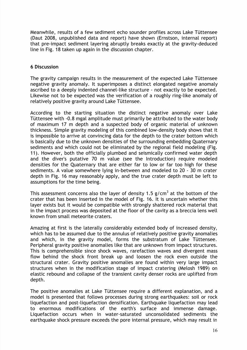
derivative that mathematically in turn traces the maximum horizontal gradientthus delineating the crater rim as position of maximum density contrast. This redline is copied to an oblique aerial photograph of Lake Tüttensee (Fig. 18), and it isevident that the crater and its rim are not synonymous to Lake Tüttensee.
Fig. 17. Horizontal second derivative of the residual anomaly establishing the ring-like
maximum density contrast (red line) at the crater rim.
Fig. 18. The crater rim deduced from the gravity second derivative in Fig. 17. Note that thephotograph is rotated by approximately 180° with respect to the map in Fig 17.
8/7/2019 Gravity survey of the Holocene Lake Tüttensee meteorite crater (Chiemgau impact event)
http://slidepdf.com/reader/full/gravity-survey-of-the-holocene-lake-tuettensee-meteorite-crater-chiemgau-impact 16/22
16
Meanwhile, results of a few sediment echo sounder profiles across Lake Tüttensee(Daut 2008, unpublished data and report) have shown (Ernstson, internal report)that pre-impact sediment layering abruptly breaks exactly at the gravity-deducedline in Fig. 18 taken up again in the discussion chapter.
6 Discussion
The gravity campaign results in the measurement of the expected Lake Tüttenseenegative gravity anomaly. It superimposes a distinct elongated negative anomalyascribed to a deeply indented channel-like structure - not exactly to be expected.Likewise not to be expected was the verification of a roughly ring-like anomaly of relatively positive gravity around Lake Tüttensee.
According to the starting situation the distinct negative anomaly over LakeTüttensee with -0.8 mgal amplitude must primarily be attributed to the water body
of maximum 17 m depth and a suspected body of organic material of unknownthickness. Simple gravity modeling of this combined low-density body shows that itis impossible to arrive at convincing data for the depth to the crater bottom whichis basically due to the unknown densities of the surrounding embedding Quaternarysediments and which could not be eliminated by the regional field modeling (Fig.11). However, both the officially plumbed and seismically confirmed water depthand the diver's putative 70 m value (see the Introduction) require modeleddensities for the Quaternary that are either far to low or far too high for thesesediments. A value somewhere lying in-between and modeled to 20 - 30 m craterdepth in Fig. 16 may reasonably apply, and the true crater depth must be left to
assumptions for the time being.
This assessment concerns also the layer of density 1.5 g/cm3 at the bottom of thecrater that has been inserted in the model of Fig. 16. It is uncertain whether thislayer exists but it would be compatible with strongly shattered rock material thatin the impact process was deposited at the floor of the cavity as a breccia lens wellknown from small meteorite craters.
Amazing at first is the laterally considerably extended body of increased density,which has to be assumed due to the annulus of relatively positive gravity anomaliesand which, in the gravity model, forms the substratum of Lake Tüttensee.
Peripheral gravity positive anomalies like that are unknown from impact structures.This is comprehensible since shock waves, rarefaction waves and divergent massflow behind the shock front break up and loosen the rock even outside thestructural crater. Gravity positive anomalies are found within very large impactstructures when in the modification stage of impact cratering (Melosh 1989) onelastic rebound and collapse of the transient cavity denser rocks are uplifted fromdepth.
The positive anomalies at Lake Tüttensee require a different explanation, and amodel is presented that follows processes during strong earthquakes: soil or rockliquefaction and post-liquefaction densification. Earthquake liquefaction may lead
to enormous modifications of the earth's surface and immense damage.Liquefaction occurs when in water-saturated unconsolidated sediments theearthquake shock pressure exceeds the pore internal pressure, which may result in
8/7/2019 Gravity survey of the Holocene Lake Tüttensee meteorite crater (Chiemgau impact event)
http://slidepdf.com/reader/full/gravity-survey-of-the-holocene-lake-tuettensee-meteorite-crater-chiemgau-impact 17/22
17
a breakdown of the framework, in a complete loss of strength and finally in aliquefaction of the rock ([1]). Due to the breakdown and liquefaction the porewater can be expelled on a grand scale leading to densification with significantvolume reduction (Lee & Albaisa 1974, Tokimatsu & Seed 1987, Montgomery et al.2003, and others). Soil subsidence on a meter scale after earthquakes as
consequence of this densification is not unusual.
Similar processes possibly implying more far-reaching strong effects must haveoccurred in the impact with the formation of the Lake Tüttensee crater. Thepostulated giant explosion of the impacting projectile and the formation of 100craters or more (the Lake Tüttensee crater included) within the impact strewnfield (Rappenglück et al. 2004, Ernstson et al. 2010) may have touched the effectsof most heavily earthquakes and possibly may have even topped them. And also thesecond prerequisite seems to be fulfilled: At the time of the impact anunconsolidated, porous and water-saturated sediment occupied the area of thetoday's Lake Tüttensee. Provided the densities of 1.7 and 1.5 g/cm3 used in the
modeling of the Grabenstätt channel are accurate, these values on watersaturation involve c. 50 % - 65 % porosity (2.5 g/cm3 matrix density) correspondingto respective large water quantities in the rock. Thus, greatest precondition forextreme shock liquefaction must have existed, probably far beyond the developingLake Tüttensee crater.
In the gravity model for the Lake Tüttensee anomaly a density increase of 0.12g/cm3 (from 1.7 to 1.82 g/cm3) is assumed. In a model of soil densificationfollowing soil liquefaction, this density increase leads to the computation of a c. 8% volume reduction. This corresponds to an 80 cm compaction of a 10 m thick
sediment layer, which is a plausible quantity and of the order of compactionobserved in earthquakes, all the more in an earthquake only the rock frameworkbreaks down expelling the pore water. A meteorite impact implying energetic massflow behind the shock front should be even far more effective with regard tocompaction of water-saturated rocks of high porosity.
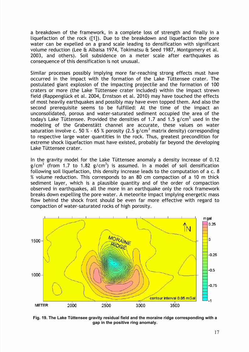
Fig. 19. The Lake Tüttensee gravity residual field and the moraine ridge corresponding with agap in the positive ring anomaly.
8/7/2019 Gravity survey of the Holocene Lake Tüttensee meteorite crater (Chiemgau impact event)
http://slidepdf.com/reader/full/gravity-survey-of-the-holocene-lake-tuettensee-meteorite-crater-chiemgau-impact 18/22
18
The obvious gap in the positive ring anomaly (Fig. 19) may indirectly support themodel of liquefaction and densification. As designated in the figure, the northernpart of Lake Tüttensee is geologically different from the rest of the field. A ridgeof relatively dense moraine material contrasts with the fluvio-glacial sands andgravels otherwise exposed everywhere. Hence, the shock front must have come
across the already existing solidification of the moraine that possibly becamerather loosened than compacted.
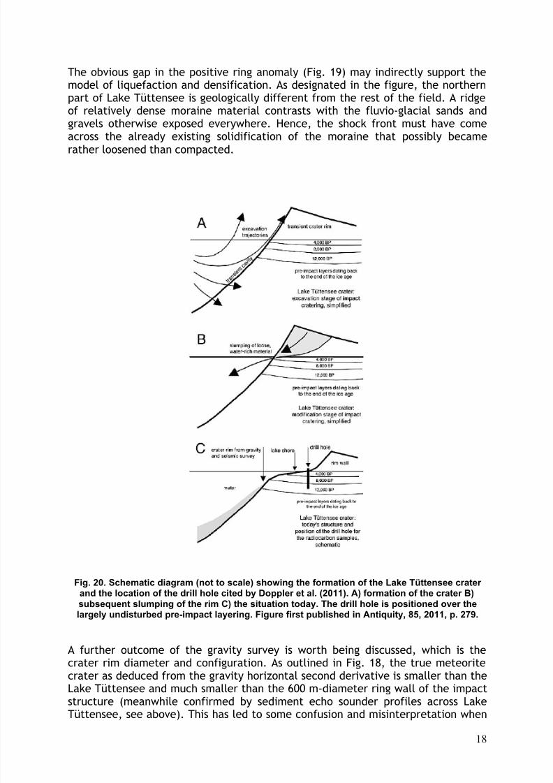
Fig. 20. Schematic diagram (not to scale) showing the formation of the Lake Tüttensee crater and the location of the drill hole cited by Doppler et al. (2011). A) formation of the crater B)subsequent slumping of the rim C) the situation today. The drill hole is positioned over thelargely undisturbed pre-impact layering. Figure first published in Antiquity, 85, 2011, p. 279.
A further outcome of the gravity survey is worth being discussed, which is thecrater rim diameter and configuration. As outlined in Fig. 18, the true meteoritecrater as deduced from the gravity horizontal second derivative is smaller than the
Lake Tüttensee and much smaller than the 600 m-diameter ring wall of the impactstructure (meanwhile confirmed by sediment echo sounder profiles across LakeTüttensee, see above). This has led to some confusion and misinterpretation when
8/7/2019 Gravity survey of the Holocene Lake Tüttensee meteorite crater (Chiemgau impact event)
http://slidepdf.com/reader/full/gravity-survey-of-the-holocene-lake-tuettensee-meteorite-crater-chiemgau-impact 19/22
19
a borehole drilled onshore by opponents of the meteorite impact origin hadencountered a sequence of peat and lake sediments obviously largely undisturbedand, from radiocarbon dating, older than the postulated impact event (Doppler etal. 2011). In their opinion, peat and sediments at the location of the drill holewithin the ring wall must appear extremely wrecked and heated from the impact.
This attests an amateurish comprehension of impact processes. Outside the originalcavity of the crater, shock intensities are already lowered to such a degree (a fewkbars maximum pressure) that minor deformations are not possibly to be seen in afew-centimeter diameter sized drill core, not to mention the absence of anydetectable enhanced temperature signature. Therefore, the arguments of Doppler etal. (2011) who further on maintain a glacial origin of Lake Tüttensee have beenrejected by Rappenglück et al. (2011) pointing to the development of the LakeTüttensee crater in the cratering process and the utterly unsuited location of theborehole for dating the impact event (Fig. 20).
One more feature of the gravity image in Fig. 17 and the crater rim outline in Fig.
18 is pointed out. Although the gravity second-derivative anomaly proves to bequite circular on the whole, a kind of triple bulge is conspicuous. This may beattributed to a superposition of the impact of a disintegrated projectile as isconsidered the case for other asymmetrical meteorite craters like e.g. the largestcrater in the Henbury, Australia, strewn field. Moreover, the doublet craterstructure in Lake Chiemsee mentioned in the Introduction points to a twin impactinto the lake. Altogether, these multiple-impact craters are most compatible withthe model of a very large disintegrated, loosely bound cosmic projectile (a cometor a rubble pile asteroid) to have produced the extensive Chiemgau impact strewnfield (Rappenglück et al. 2004, Ernstson et al. 2010).
7 Conclusions
The gravity measurements at Lake Tüttensee have shown that the original purposeof determining the crater depth by modeling the water (and organic matter) bodywas not achieved. The reason is the to this degree unforeseen complex densitydistribution in the surrounding rocks. At least, the gravity modeling shows thatneither the official water depth nor the diver's alleged 70 m define the true impactcrater. A depth between 20 m and 30 m seems to be most plausible, although themaximum depth of the transient crater in the excavation stage was probably muchlarger. As shown in Fig. 20, due to the extremely unconsolidated excavated
material full of water, large masses must have slumped from a transient crater rimwall widely backfilling the cavity. This scenario explains the unusual discrepancybetween the today's ring wall diameter (600 m) and the crater true diameter (300m).
Perhaps the most intriguing result of the gravity survey is the existence of a broadring-like zone of increased density around Lake Tüttensee (and possibly below it). Afully consistent model considers the impact shock causing a rock densification inthe wake of liquefaction and an additional compaction in the course of highlyenergetic mass flow behind the shock front starting from the impact point. Thus,the impact origin for the Lake Tüttensee kettle is also strengthened from
geophysical investigations. By contrast, a formation as a glacial dead-icedepression initiated by the melting of glacier ice and subsequent subsidence of
8/7/2019 Gravity survey of the Holocene Lake Tüttensee meteorite crater (Chiemgau impact event)
http://slidepdf.com/reader/full/gravity-survey-of-the-holocene-lake-tuettensee-meteorite-crater-chiemgau-impact 20/22
20
fluvio-glacial material (Doppler & Geiß 2005, Darga & Wierer 2009, Doppler et al.2010) meets insurmountable problems to explain the densification.
If the model remains valid, more detailed investigations within the frame of impactresearch would be a worthwhile task, because hitherto on Earth comparable
situations have not been recognized and studied. Further studies may beinteresting for the understanding of impact cratering in targets composed of unconsolidated and extremely water-rich rocks. On Mars, liquefaction due to impactevents is considered to be possible (Clifford 2004, Wang et al. 2005) based on thecomparison with terrestrial earthquake-induced liquefaction, and Komatsu et al.(2007) suggest that layered ejecta structures and small mounds in the vicinity of impact craters in high northern latitudes of Mars could be explained by thismechanism.
Acknowledgements
Much support for the gravity survey is greatly appreciated. Thanks go to: Chiemgau ImpactResearch Team (CIRT), Chieming Rescue Service, Grabenstätt and Vachendorf municipalities,University of Würzburg, T. Ernstson, C. Soika, U. Schüssler, and last but not least Baron D.Freiherr von Wrede, owner of Lake Tüttensee.
References
[1] http://www.ce.washington.edu/~liquefaction/html/main.html
CIRT, Chiemgau Impact Research Team (2004): Did the Celts see a cometaryimpact 200 B.C.? http://www.astronomy.com/asy/default.aspx?c=a&id=2519
CIRT, Chiemgau Impact Research Team (2005): Kommentar zu: Der Tüttensee imChiemgau - Toteiskessel statt Impaktkrater, von Gerhard Doppler und Erwin Geiss(Bayerisches Geologisches Landesamt). http://www.chiemgau-impact.com/kommentar.html.
Clifford, S. M. (2004): The early climate of Mars: warm, cold or forever unknowable?Ambiguities resulting from impact seismicity and hydrothermal activity. 2nd Conf. onEarly Mars, Abstract #8076.
Darga, R. and Wierer, J.F. (2009): Auf den Spuren des Inn-Chiemsee-Gletschers:Exkursionen (Wanderungen in die Erdgeschichte 27): 174–85. München: Pfeil.
Daut, G. (2008): Bericht zu den Geländearbeiten des Projektes: "NacheiszeitlicheKlimageschichte des Chiemgaus anhand von Sedimenten des Chiemsees und desTüttensees bei Grabenstätt unter besonderer Berücksichtigung der mittelalterlichenWärmezeit und der Einflussnahme des Menschen auf die Umwelt". - Unpublishedreport, University of Jena, Institute of Geography.
Doppler, G. and Geiss, E. (2005): Der Tüttensee im Chiemgau – Toteiskessel statt
Impaktkrater. http://www.geologie2.bayern.de/app/media/user-files/1118154325830_tuettensee.pdf.
8/7/2019 Gravity survey of the Holocene Lake Tüttensee meteorite crater (Chiemgau impact event)
http://slidepdf.com/reader/full/gravity-survey-of-the-holocene-lake-tuettensee-meteorite-crater-chiemgau-impact 21/22
21
Doppler, G. Geiss, E., Kroemer, E., and Traidl, R. (2011): Response to ‘The fall of Phaethon: a Greco-Roman geomyth preserves the memory of a meteorite impactinBavaria (south-east Germany)’ byRappenglück et al. (Antiquity 84). - Antiquity, 85, 274-277.
Ernstson, K. (2005): Gravimetrische Untersuchungen bei Grabenstätt: Anzeichen für einen Impaktursprung des Tüttensee-Kraters (Chiemgau-Impakt) erhärtet.http://chiemgau-impakt.de/Gravimetrische_untersuchungen.pdf
Ernstson, K., Mayer, W., Neumair, A., Rappenglück, B., Rappenglück, M.A.,Sudhaus, D., and Zeller, K.W. (2010), The Chiemgau Crater Strewn Field: Evidenceof a Holocene Large Impact Event in Southeast Bavaria, Germany: Journal of Siberian Federal University, Engineering & Technologies 3 (1), 72-103.
Komatsu, G., Ori G.G., Di Lorenzo, S., Rossi A.P., and G. Neukum, G. (2007):Impact-induced liquefaction in water-rich, unconsolidated, near-surface sediments on
Mars. LPSC XXXVIII, Abstract 189.pdf.
Lee, K.L., and A. Albaisa. (1974): Earthquake induced settlements in saturatedsands. - J. Geotech. Eng. Div., ASCE, 100(4), 387-406.
Martin, M.R. (2007): Zu den für die Eiszeitglaziologie wichtigen kleinen Hohlformenund zur Frage des Entstehens der Sölle. Berlin (viademica).
Melosh, H.J. (1989): Impact cratering. A geologic process. Oxford Univ. Press,Oxford, 245 pp.
Montgomery, D.R., Greenberg, H.M., and Daniel T. Smith, D.T. (2003): Streamflowresponse to the Nisqually earthquake. - Earth Planet. Sci. Let., 209, 19-28.
Rappenglück et al. (2004): The Chiemgau impact event in the Celtic Period: evidenceof a crater strewn field and a cometary impactor containing presolar matter.http://www.chiemgau-impact.com/.
Rappenglück, B., Rappenglück, M.A., Ernstson, K., Mayer, W., Neumair, A.,Sudhaus, D., and Liritzis, I. (2010): The fall of Phaethon: a Greco-Roman geomythpreserves the memory of a meteorite impact inBavaria (south-east Germany). -
Antiquity, 84, 428-439
Rappenglück, B., Rappenglück, M.A., Ernstson, K., Mayer, W., Neumair, A.,Sudhaus, D., and Liritzis, I. (2011): Reply to Doppler et al . ‘Response to “The fall of Phaethon: a Greco-Roman geomyth preserves the memory of a meteorite impact inBavaria (south-east Germany). - (Antiquity 84)' . - Antiquity, 85, 278-280.
Schüssler et al. (2005): Das Impakt-Kraterstreufeld im Chiemgau. - Eur. J. Mineral.17, Beih. 1: 124.
Tokimatsu, K., and H.B. Seed. (1987): Evaluation of settlements in sands due to
earthquake shaking. J. Geotech. Eng. Div., ASCE, 113(8), 861-78.

8/7/2019 Gravity survey of the Holocene Lake Tüttensee meteorite crater (Chiemgau impact event)
http://slidepdf.com/reader/full/gravity-survey-of-the-holocene-lake-tuettensee-meteorite-crater-chiemgau-impact 22/22
Wang, C.-y, Manga. M., and Wong, A. (2005): Floods on Mars released fromgroundwater by impact, Icarus, 175, 551-555.