Embed Size (px)
Citation preview
GvOVAL D'ORGEOPHYSIQUE
42B01NW0082 2.17900 FOLEYET 010
GRAVIMETRIC SURVEYproperty of
NORANDA EXPLORATION CO. LIMITEDFOLEYET Property #92-C
Foleyet TownshipProvince of Ontario
May 1993
P. Lortie R. Turcotte
MOV 1 3 IS!.'/
GEOSCIENCE ASSESSMENT OFFICF __
93-953
SERVICES EN LEVES GEOPHYSIQUES - GEOPHYSICAL SERVICES50, boul. Lamaque, VAL D'OR (Quebec) J9P 2H6 T*l. : (819) 825-6529 Fax : (819) 825-1342
SUMMARY
In March 1993, a gravimetric survey was carried out
on the property FOLEYET Property #92-C, owned by
NORANDA EXPLORATION CO. LIMITED, after the successful
results of an initial test performed during the summer of
1992. The gravimetric survey was performed to
investigate the strike length of electromagnetic
conductors previously detected by an HLEM survey.
A total of 12 line-kilometres (317 stations) was
added by this survey to the original 1.1 line-km (41
stations) of the initial test. This survey covers grid
lines from 7+OOE to 23+OOE and was done with a Lacoste St
Romberg gravity meter. An electronic level manufactured
by GDD was used to measure the relative elevation of the
ground at each station.
Three horizons characterized by narrow and wide
anomalies of small positive values of 0.2 to 0.4 mgal
were detected throughout the survey area. The most
northern horizon is associated with an electromagnetic
conductor and should definitely be investigated. The
other anomalous horizons may be caused either by bedrock
variations, lithological changes or possibly massive
sulphide bodies at depth.-*
'^ ' ; - 't •....•:-. O JL G ^
Q/O
42B01NW0082 2.17900 FOLEYET Q 1 Q C
-i-
TABLE OF CONTENTS
Page
Table of contents........... .. .. . .. . . .. . .. . .... . . . . . .. . . .. . .. i
Introduction.................................................l
Property, location and access. .. ... . . ......... . .. .. . . . . . . . . . . l
Geophysical survey........................... . .. . .. . . .. . .. . . . 2
Survey specifications.................. . . . . .. . . . . . .. . .. . . . . . . 2
Data reduction specifications..... .. .. .. . .. . . . . .. . .. . . . . . .. . . 3
Results and interpretation......................... . . . .. . .. . . 5
Conclusion and recommendations...............................7
Certificates...............................................8-9
LIST OF FIGURES:
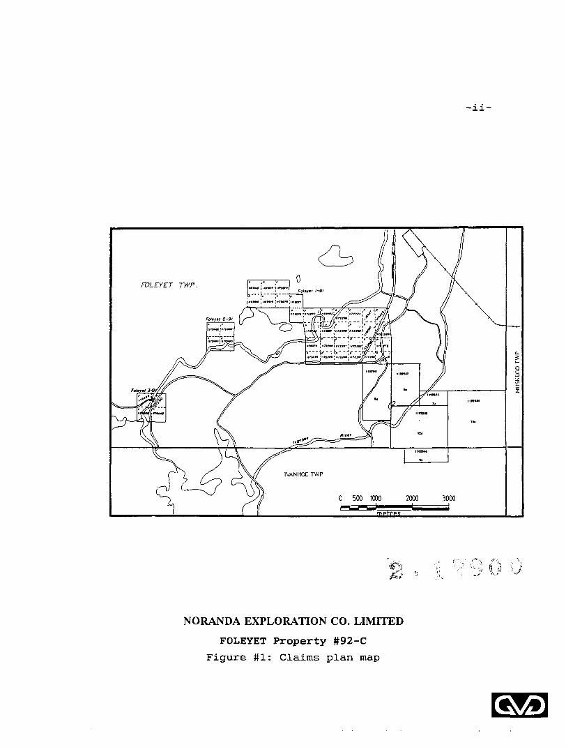
Figure #1: Claims plan map..................................ii
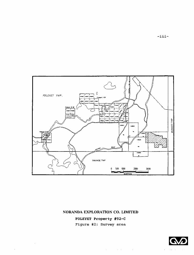
Figure #2: Survey area.....................................iii
LIST OF MAPS:
DRAWING NO. GRAVIMETRIC SURVEY
6.l Bouguer Gravity and
Elevation Profiles
6.3 Bouguer Contours and
Elevation Profiles
QvO
-11-
0 500 1000 2000 3000
NORANDA EXPLORATION CO. LIMITED
FOLEYET Property #92-C
Figure. # 1: Claims plan map
QvO
-iii-
0 500 1000 2000 3000
NORANDA EXPLORATION CO. LIMITED
FOLEYET Property #92-C
Figure #2: Survey area
-1-
INTRODUCTION
In March 1993, a gravimetric survey was carried out on a
property owned by NORANDA EXPLORATIONS CO. LIMITED, FOLEYET
Property #92-C, Foleyet Township, Province of Ontario.
This survey was designed to locate positive gravimetric
anomalies associated with massive sulphide mineralization
intersected in a drillhole on the property (after magnetic and
horizontal loop electromagnetic surveys).
PROPERTY, LOCATION AND ACCESS
The property is located approximately 5 kilometres SSE of
the town of Foleyet in the township of the same name, Province
of Ontario.
This property is easily accessible from Highway #101 south of Foleyet, and then via dirt roads and trails to the
southeast.
The property claim numbers are registered with the
Ministry of Northern Development and Mines and are shown in
figure #1. The area covered by the gravimetric survey is
shown in figure #2 of the present report.
Gs/O
-2-
GEOPHYSICAL SURVEY
A gravimetric survey and a relative elevation survey
(values not tied to the national or provincial geodesic
database) were carried out on a portion of the property from
March lith to March 21st, 1993. An approximate total of 12
line-kilometres were covered with a LaCoste 6 Romberg gravity
meter, G-642, and with a GDD electronic level meter coupled to
a 50-metre cable.
A total of 317 stations were measured every 50 metres
(with intermediate values over the electromagnetic conductors)
over 15 grid lines, L7+OOE to L23+OOE.
Results of a test survey, carried out on grid lines
18+OOE and 19+OOE during the summer of 1992, were provided by
NORANDA EXPLORATIONS CO. LIMITED This test survey was
performed with a CG-2 gravity meter manufactured by Scintrex
and covered 41 stations spaced every 25 metres.
SURVEY SPECIFICATIONS
The gravimetric survey was carried out along grid lines
oriented N-S and cut at a 100-metre interval. The grid lines
were chained and stations marked every 25 metres.
-3-
The gravimetric and relative elevation measurements were
done simultaneously on plates above the ground. Relative
elevation measurements included the elevation of the ground
and of the height of the gravimetric plate (instrument) at
each station. The relative elevation values presented on the
maps are ground elevation values.
The gravimetric and relative elevation measurements were
tied to a base station located at an easily accessible point
along the base line, at the following coordinates: 18+92E and
0+05N.
Arbitrary values of 100.00 metres and 10.00 mgals were
selected for the relative elevation and gravimetric values of
the base station (at ground level).
The gravity meter and the electronic level meter
permitted measurements to be made with a resolution of 0.01
mgal and 0.001 metre respectively. It is estimated that the
noise level of the survey is such that Bouguer Anomaly and
elevation values have respective accuracies of 0.07 mgal and
0.05 metre.
DATA REDUCTION SPECIFICATIONS
The gravimetric measurements were reduced to obtain
Bouguer Anomaly values. The following corrections were
applied to the measurements:
-4-
1. Earth-tide correction: calculated with a software
developed by the Geological Survey of Canada. Resolution
of 0.001 mgal.
2. Meter drift correction: calculated from the closure
values at the base station, after the Earth-tide
correction was done. Resolution of 0.01 mgal.
3. Latitude correction: calculated from the base line with
the equations 0.0008071 sin 2@ mgal/metre, where @ is the
reference latitude (48 0 12'N). The reference longitude
was 82"25'W. Resolution of 0.01 mgal.
4. Free-air correction: calculated with the equation -
0.3085 mgal/metre of the relative elevation difference
between each station and the base station assumed datum
(100.00 metres). Resolution of 0.01 mgal.
5. Bouguer correction: calculated with the equation 0.112
mgal/metre of the relative elevation difference between
each station and the base station assumed datum (100.00
metres), and an assumed density of 2.67 gr/cc.
Resolution of 0.01 mgal.
No topographic corrections were done for this project, as
most topographic effects were evaluated to be less than 0.03
mgal.
GvO
-5-
A gravity meter constant of 1.02745 was used to change
the meter measurements into gravimetric values. The Bouguer
Anomaly was obtained by adjusting the calculated gravimetric
value at each station to the value of the local base station.
The results of the test survey (1992) were also adjusted
as follows: the original elevation values were not changed,
but the base level of the Bouguer Anomaly was adjusted by
substracting a value of 109.73 mgal to both grid lines (18+OOE
and 19+OOE) values.
RESULTS AND INTERPRETATION
The gravimetric results indicate a very subdued regional
gradient from east to west, with very little variation from
south to north.
Small positive anomalies with amplitude variations of 0.2
to 0.5 mgal were detected on several grid lines throughout
most of the survey area. Most of these anomalies form three
horizons striking approximately E-W to SE-NW (from east to
west).
One of these horizons (the northern trend) is caused by
a near surface body of higher density, with respect to the
local environment, and is closely associated with the position
of an electromagnetic conductor. The strongest anomaly along
this horizon is located on L18+OOE at 0+85N.
-6-
A second horizon, from L15+OOE to Lll+OOE, has a similar
amplitude but a much wider shape, possibly caused by the
presence of a body at depth or a variation in bedrock
topography (bedrock closer to surface). The most definite
anomaly for this horizon is located on L15+OOE at 0+75N.
A third horizon located south of the base line on L17+OOE
and L18+OOE is characterized by wide positive anomalies of
small amplitude, possibly caused by a body at an approximate
depth of 100 metres. The anomaly is somewhat similar on both
grid lines.
Another positive anomaly was detected on L7+OOE at 3+75N
with no apparent extension to the east. It is suggested to
extend the survey coverage to the west for a better evaluation
of this trend.
The smaller variations of the Bouguer Anomaly profiles
are probably associated with bedrock topography and/or
lithological variations.
GvO
-7-
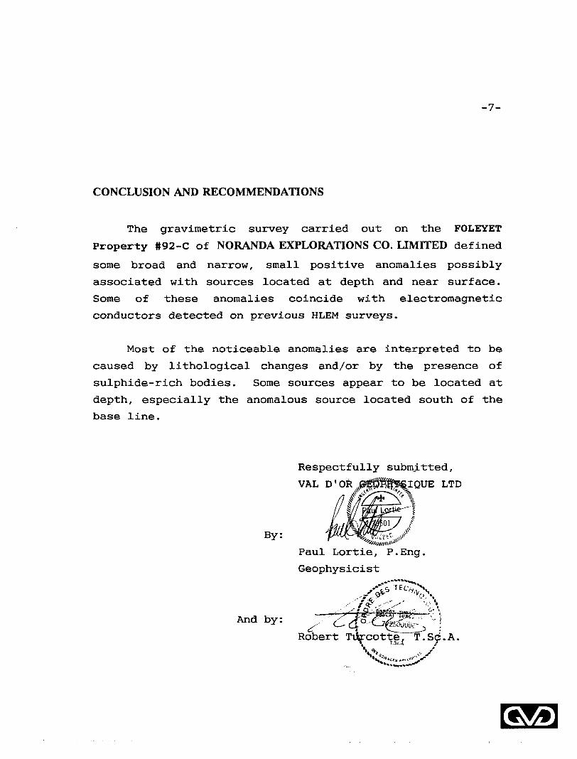
CONCLUSION AND RECOMMENDATIONS
The gravimetric survey carried out on the FOLEYET
Property #92-C of NORANDA EXPLORATIONS CO. LIMITED defined
some broad and narrow, small positive anomalies possibly
associated with sources located at depth and near surface.
Some of these anomalies coincide with electromagnetic
conductors detected on previous HLEM surveys.
Most of the noticeable anomalies are interpreted to be
caused by lithological changes and/or by the presence of
sulphide-rich bodies. Some sources appear to be located at
depth, especially the anomalous source located south of the
base line.
Respectfully submitted.
VAL D'OR JJSJPfffSSIQUE LTD//Jfrg^'X
Paul Lortie, P.Eng.
Geophysicist
And by:v-*' ""—" ^—^ —— r-~"^viwi, ^ ,
Robert Tvircotte, ^T.Sc'.A. V
-8-
CERTIFICATE
THIS IS TO CERTIFY THAT:
I reside at 681 Boulle, Beloeil, province of Quebec, since
1990.
I am a graduate of Ecole Polytechnique, Universite de
Montreal, where I have received a B.Se.A. in Geological
Engineering in 1979.
I have been engaged in exploration geophysics since 1977, and
have been practicing as a professional engineer since 1979.
I am a member of the Ordre des Ingenieurs du Quebec since
1979.
I am a member of the Prospectors S Developers Association of
Canada, the Quebec Prospectors Association, the Association
des Professionnels en Geologie et Geophysique du Quebec, and
the Societe de Geophysique du Quebec.
I do not hold nor do I expect to receive an interest of any
kind in the claims held by NORANDA EXPLORATIONS CO. LIMITED
Signed in Val d'Or, this May 20,
By:
Paul Loftie, P.Eng.
Geophysicist.
GvO
-9-
CERTIFICATE
THIS IS TO CERTIFY THAT:
I am a resident of Val d'Or, province of Quebec, since 1977.
I am a technologist graduated from "College du Nord-Ouest",
Rouyn-Noranda, Quebec in 1977.
I have been actively engaged in geophysical exploration since
1977 and have acquired a wide range of experience in
geophysical methods and techniques.
I am a member of "Corporation professionnelle des Technologues
des Sciences Appliquees du Quebec" and also a member of the
Quebec prospectors association and of the Canadian Institute
of Mining and Metallurgy.
I do not hold nor do I expect to receive an interest of any
kind in these claims held by NORANDA EXPLORATIONS CO.
LIMITED
Signed in Val d 'Or, this May 20, 1993.
Bv:Robert
QvO
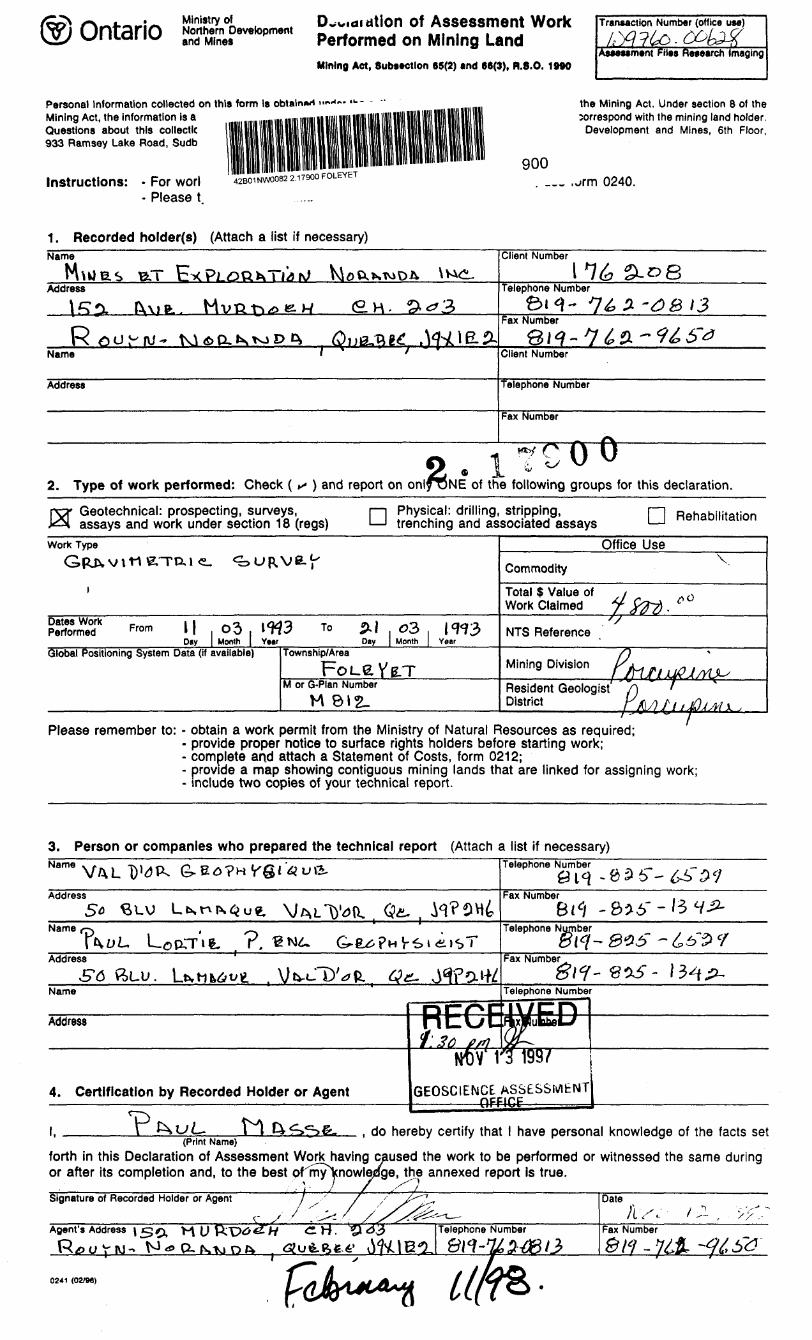
Ministry ofNorthern Developmentand Mines
of Assessment Work Performed on Mining LandMining Act, Substctlon 65(2) and 68(3), R.8.O. 1MO
Personal Information collected on this form Is obtains Mining Act, the information is a Questions about this collecllc 933 Ramsay Lake Road, Sudb
Instructions: - For worl - Please t
11142BO' NW0082 2.17900 FOLEYET
Transaction Number (office use)
Tusessment FHes Research Imaging
the Mining Act. Under section 8 of thecorrespond with the mining land holder.
Development and Mines, 6th Floor,
900_ ,orm 0240.
1. Recorded holder(s) (Attach a list if necessary)Name
Address
rs^juj-'fvj- Ki d) D- 1\ to D c^ Q -uV-Qlt. , ^4-jOE.2-Name ' '
Address
Client Number
Telephone Number2-^8
2-3B 13Fax Number
@ i /^ f*i y ^i -~* f̂ y ^\ /^ IT" y c? *^ ' w? u^ ^^Client Number
Telephone Number
Fax Number
**tf O f\ 1V. 1 -i - U u2. Type of work performed: Check ( *- ) and report on onl^ONE of the following groups
f
for this declaration.
Geotechnical: prospecting, surveys, assays and work under section 18 (regs) D Physical: drilling, stripping,
trenching and associated assays [~~| Rehabilitation
Work Type
Gpjx v
i
Dates Work Performed
ntterraKi. ^URVE.^
From k| 03 l^H3 To p.| 03 IW3Day | Month | Year Day | Month | Year
Global Positioning System Data (if available) Township/Area
FoLeYB-TM or G-Plan Number
M 812.
Office Use
Commodity
Total $ Value of y o Work Claimed jr jfrrf .
'S
NTS Reference
Mining Division r i^i m * .j ̂ l^ij^QJ/yu^
Resident Geologist f\ ' District rX)y?///^^!,
Please remember to: - obtain a work permit from the Ministry of Natural Resources as required;- provide proper notice to surface rights holders before starting work;- complete arid attach a Statement of Costs, form 0212;- provide a map showing contiguous mining lands that are linked for assigning work;- include two copies of your technical report.
3. Person or companies who prepared the technical report (Attach a list if necessary)Telephone Number
Address Fax Number
r.Telephone Number
Address
ff6Fax Number
Name Telephone Number
4. Certification by Recorded Holder or Agent GEOSCIENCE ASSESSMENT pFFIHF
l, ______V *-^UL- i'tl4^^)fe. , do hereby certify that l have personal knowledge of the facts set(Print Name)
forth in this Declaration of Assessment Work having caused the work to be performed or witnessed the same during or after its completion and, to the best ormy\nowladge, the annexed report is true.
- ^ - 7 J s t
0241 (02/96)
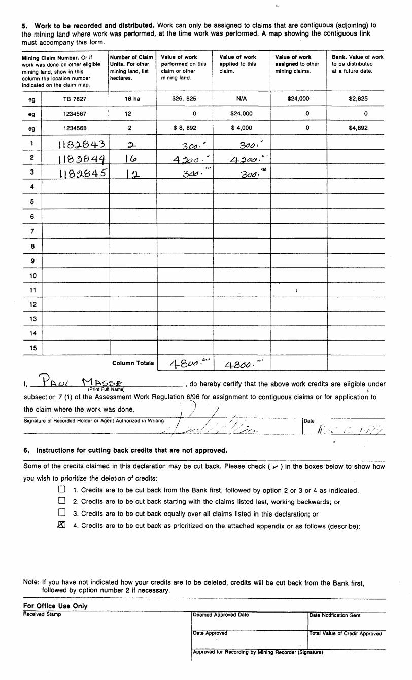
5. Work to be recorded and distributed.the mining land where work was performed, must accompany this form.
Work can only be assigned to claims that are contiguous (adjoining) to at the time work was performed. A map showing the contiguous link
Mining Claim Number. Or if work was done on other eligible mining land, show in this column the location number indicated on the claim map.
eg
eg
eg
1
2
3
4
5
6
7
8
9
10
11
12
13
14
15
TB 7827
1234567
1234568
118^643
1183^4^
liases"
Number of Claim Units. For other mining land, list hectares.
16 ha
12
2
3-
\(*
la
Column Totals
Value of work performed on this claim or other mining land.
S26, 825
0
S 8, 892
3 A*-'
4^cJ3^ ' '
4-8*0 .~
Value of work applied to this claim.
N/A
$24,000
S 4,000
3^'"
4-,2^-"300'"*
4&J4 - ~'
Value of work assigned to other mining claims.
S24.000
0
0
)
Bank. Value of work to be distributed at a future date.
S2.825
0
S4,892
l, H , do hereby certify that the above work credits are eligible under(Print Full Name) (
subsection 7 (1) of the Assessment Work Regulation 6/96 for assignment to contiguous claims or for application to
the claim where the work was done. . ) /Signature of Recorded Holder or Agent Authorized in Writing l Date
/-A 7 X
6. Instructions for cutting back credits that are not approved.
Some of the credits claimed in this declaration may be cut back. Please check ( s ) i n the boxes below to show how
you wish to prioritize the deletion of credits:
D 1. Credits are to be cut back from the Bank first, followed by option 2 or 3 or 4 as indicated.
D 2. Credits are to be cut back starting with the claims listed last, working backwards; or
D 3. Credits are to be cut back equally over all claims listed in this declaration; or
J3 4. Credits are to be cut back as prioritized on the attached appendix or as follows (describe):
Note: If you have not indicated how your credits are to be deleted, credits will be cut back from the Bank first, followed by option number 2 if necessary.
For Office Use Only___________^_____Received Stamp Deemed Approved Date
Date Approved
Date Notification Sent
Total Value of Credit Approved
Approved for Recording by Mining Recorder (Signature)
Ontario
Ministry ofNorthern Developmentand Mines
Mlnlstere du Developpement du Nord ei des mines
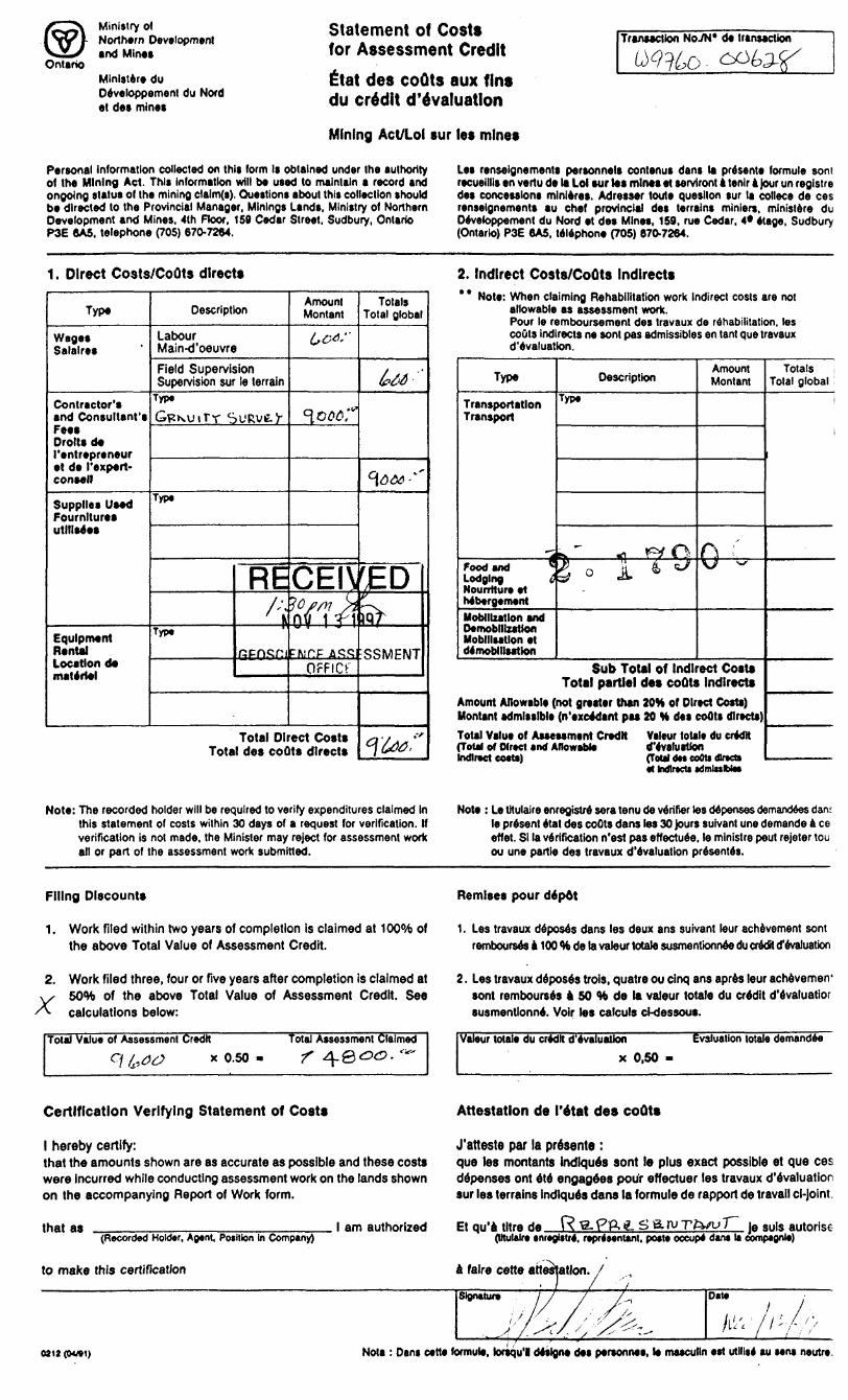
Statement of Costs for Assessment Credit
ittat des couts aux fins du credit devaluation
Mining Act/Lol sur let mine*
Transaction HoM* de transaction
Personal Information collected on this form Is obtained under the authority of the Mining Act. This information will be used to maintain a record and ongoing status of the mining clalm(s). Questions about this collection should be directed to the Provincial Manager. Minings Lands, Ministry of Northern Development and Mines, 4th ROOT, 159 Cedar Street, Sudbury, Ontario P3E 6A5. telephone (705) 670-7264.
Les renseignements personnels contenus dans la presents formule soni recueillis en vertu de la Lol sur tat mints et servtront a tenlr 4 Jour un registre des concessions mlnleres. Adresser toute quesilon sur la collece de ces renseignements au chef provincial des terrains minien, ministere du Developpement du Nord et des Mines, 159, rue Cedar, 4* etage. Sudbury (Ontario) P3E 6A5, telephone (705) 670-7264.
1. Direct Costs/CoOts directs
Type
Wages Salalres
Contractor's and Consultant's Fee* Drolls de ('entrepreneur et de I'expert- consell
Supplies Used Fournltures utilises*
Equipment Rental Location de materiel
Description
LabourMain-d'oeuvre
Field Supervision Supervision sur le terrain
Type
Typ*
Typ.
RE/-.
Amount Montan)6**"
^006?
Totals Total global
U*-"
*fc*."
CEIVEDl0//* s*OY 1 ri
OFFICF
Total Direct Cost* Total de* coOts direct*
Wf
SSMENT
c\u*:'
2. Indirect Costs/CoOts Indirect** * Note: When claiming Rehabilitation work Indirect costs are not
allowable as assessment work. Pour le remboursement des Iravaux de rehabilitation, les coOts Indlrects ne sont pas admissibles en (ant que travaux d'evaluation.
Type
Transportation Transport
Food and ^Lodging C Nourrtture et MbergementMoMllxatlon and Oemoblllzatlofl Mobilisation et demobilisation
Description
Typ*
s..^ iq ^Ql o 1 t ^
Amount Montan!
0-^
Sub Total of Indirect Costs Total partial des coOts Indlrects
Amount Allowable (not greater than 20H of Direct Costs) Montan! admissible (n'excedant pas 20 H des couts directs)
Total Value of Assessment Credit Valeur total* du credit (Total of Direct and Allowable devaluationIndirect cartel nant dM teOlt Otto*
Totals Total global
i
i
l hdlrtcU edmlwIWei
Note: The recorded holder will be required to verify expenditures claimed In this statement of costs within 30 days of a request for verification. If verification is not made, the Minister may reject for assessment work all or part of the assessment work submitted.
Note : Le tltulaire enregistre sera tenu de verifier tes depenses demandees dam le present etat des coOts dans les 30 Jours suivant une demande Ace effet. SI la verification n'est pas effectuee. le ministre pout rejeter tou ou une partie des travaux d'evaluation presentes.
Filing Discount*
1. Work filed within two years of completion is claimed at 1000̂ of the above Total Value of Assessment Credit.
Remises pour depot
1. Les travaux deposes dans les deux ans suivant leur achievement sont rembourses a 100 "to de la valour totale susmentfonnee du credit d'evaluation
2. Work filed three, four or rive years after completion is claimed at
X 50V) of the above Total Value of Assessment Credit. See calculations below:
Total Value of Assessment Credit
9 (000 x 0.50
Total Assessment Claimed•f
2. Les travaux deposes trois, quatre ou cinq ans apres leur achevemerr sont rembourses a 50 M* de la valour totale du credit d'evaluatior susmentlonne. Voir les calculs d-dessous.
Valeur totale du credit d'evaluation
x 0,50
Evaluation totale demandee
Certification Verifying Statement of Costs
l hereby certify:that the amounts shown are as accurate as possible and these costs were incurred while conducting assessment work on the lands shown on the accompanying Report of Work form.
that as(Recorded Holder, Agent, Position in Company)
to make this certification
l am authorized
Attestation de I'etat des coQts
J'atteste par la presents :que les montants Indlques sont le plus exact possible et que ces depenses ont ete engagees pour effectuer les travaux d'evaluation sur le* terrains indlques dans la formule de rapport de travail cl-joint.
Et qu'a litre da R-g.PP.iL S&ruTfa/u ]A Suls autorise (Utulalre tnr*gistr4, reprtonUnt, pott* oecup* dan* la comptonle)
a falre cette attestation,• l
OJ12 (0*W1) Nota : Dans cette formule, lorsqu'l designs des personnee, le masculln est utllls* au sens neutre
Ministry ofNorthern Developmentand Mines
Ministere du Developpement du Nord et des Mines
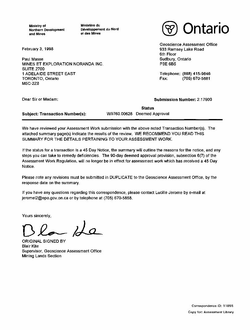
Februarys, 1998
Paul MasseMINES ET EXPLORATION NORANDA INC.SUITE 27001 ADELAIDE STREET EASTTORONTO, OntarioM5C-2Z8
OntarioGeoscience Assessment Office 933 Ramsey Lake Road 6th Floor Sudbury, Ontario P3E 6B5
Telephone: (888)415-9846 Fax: (705) 670-5881
Dear Sir or Madam:
Subject: Transaction Number(s):
Submission Number: 2 .17900
StatusW9760.00628 Deemed Approval
We have reviewed your Assessment Work submission with the above noted Transaction Number(s). The attached summary page(s) indicate the results of the review. WE RECOMMEND YOU READ THIS SUMMARY FOR THE DETAILS PERTAINING TO YOUR ASSESSMENT WORK.
If the status for a transaction is a 45 Day Notice, the summary will outline the reasons for the notice, and any steps you can take to remedy deficiencies. The 90-day deemed approval provision, subsection 6(7) of the Assessment Work Regulation, will no longer be in effect for assessment work which has received a 45 Day Notice.
Please note any revisions must be submitted in DUPLICATE to the Geoscience Assessment Office, by the response date on the summary.
If you have any questions regarding this correspondence, please contact Lucille Jerome by e-mail at [email protected] or by telephone at (705) 670-5858.
Yours sincerely,
ORIGINAL SIGNED BYBlair KiteSupervisor, Geoscience Assessment OfficeMining Lands Section
Correspondence ID: 11855
Copy for: Assessment Library
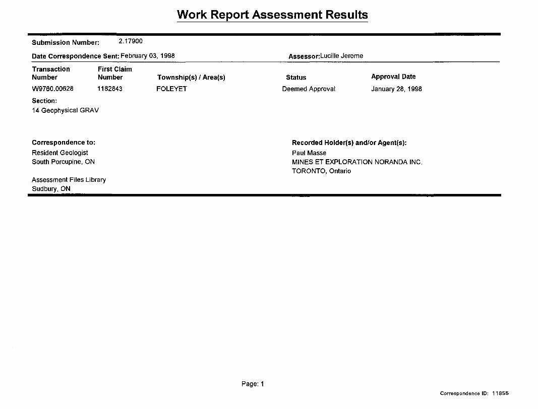
Work Report Assessment Results
Submission Number: 2 .17900
Date Correspondence Sent: February 03, 1998 AssessorLucille Jerome
Transaction Number
First Claim Number
W9760.00628 1182843
Section:14 Geophysical GRAV
Township(s) l Area(s)
FOLEYET
Status
Deemed Approval
Approval Date
January 28, 1998
Correspondence to:Resident Geologist South Porcupine, ON
Assessment Files Library Sudbury, ON
Recorded Holder(s) and/or Agent(s):Paul MasseMINES ET EXPLORATION NORANDA INC.TORONTO, Ontario
Page: 1Correspondence ID: 11855
Ill
002
MU
SK
EG
O
TO
WN
SH
IP
f" T
~
*l ~
*"'i 4
'l
r'-1 M 11 J1
^-i?
539400 E
5388500 N -
5388400 N-
5388300 N -
5388200 N-
5388100 N-
5388000 N-
5387900 N -
5387800 N-
5387700 N-
5387600 N-
5387500 N -
5387400 N -
5387300 N-
5387200 N-
5387100 N-
5387000 N-
5386900 N-
5386800 N-
5386700 N-
5386600 N -
5386500 N-
5386400 N-
5386300 N -
5386200 N-
5386100 N-
5386000 N-
5385900 N -
5385800 N-
5385700 N-
539600 El
539800 El
540000 E 540200 El
540400 E 540600 E 540800 El
541000 E 541200 El
541400 E 541600 E 541800 El
542000 E 542200 E 542400 El
542600 E 542800 E 543000 E 543200 E
XX
10.37-r 111.53 10.40j112.72 10.20-i-111.85x iu.00yuan 10.
A 10.36-1111.23 M0.321108.28 ,10.14-r 108.12
1 182.843 10.32 105.97 10.34 107.18 105.41\ fp.20 106.42
10.23J100.25/ 10.354-103.87 10.38+102.29 10.32-Aoi.92 10.103.67 iq.13-r 105.57 9^95 j 105.44
10.29 \ 9B.03 10.36 4 99.88 t '02.13 10.27 \ 1 00.38 1047H TO.97 10.1
10.26 + 97.57 10.24499.31 .24/10.374-99.83 10^99.45\\0.09 J-100.61 10.034 101.56 1 1828441.6 unitsM30IJ- 100.52 10.25 j'98.66^ 10.33 li99
10.21+07.75 10.37 + 97.88
f'98.55 V 10.47 \m.l2 1 0.2X10.1/j 102.44 JI0.35J96.15 01 10.36 f S8.37 10l5T|98771 10.32
10.381,98.35 10.33}'98.56 10.38
+102.70 10.294100.11 1)0.27-1-9^97 1
9.78 T 102.17 9.70 T 102.70 9.59 T 102.901 l l\ 9f.66 :: 102.70 9.53 : 103.00
7^-101.32 9^- 102.70 9.5^-102.50100.33 ( 9.86I J101.67
16 +1 98.96 10.06499.^2 \ 9.79^000.15 9.554-102.20 9:63^04.66 9.64^06.12 ,9.68 T 107.05 9.66/042!
.84,4 lOOX. 9.7i198.98 10.38 4|98.86 \10.22l
9.93TT8CL87 \ 9.73 4 102.30
10.2df99.42 9.99.499.89 9.93} 100.19 9.98-1-101.80 9.9.90\ 9.6ft 4 102.85 9469 j 104.29
'.TO V 102.84 9.J67
l i
l H.99.01 10.474,99.18 10.30*99.45
43 f; 99.06 10.43 4! 99.44 10.281 -l* 99.
10*26 + 104.50 10.3^100.90 1D l 9.94 + 99)66 l 1 0/274-101.10
9.95 f 9^.71 | 10125'rf 100.70 10.1\4 1(JO.10)34 4 104.68 l
BASFIIMF...I.,
'99.04 10.39 4'9999.52^-10.15 {f 99.38 J 1 0.06 l 99.58 9.99 i ̂ 9.62 \ 10.iaj|- 100.60 10.21
6-''90.27 10.33 l'99.11 1
O.ir "99.86 10.274,100.20 9^4/99.50
- 99.91
9.99^T98J? 10.04 4 99.70.53 /9.22I99.89
9.50^)00.20 9.43-^100.13 9.35-^99.88 9.22-^-99.79
F93-2
GRID 92C
SKEGO TWP.IVANHOE~JWP~.
1182846 3 units
GRID 92A Muskeo
i539400 E 539600 E 539800 E 540000 E 540200 E 540400 E 540600 E 540800 E 541000 E 541200 E 541400 E 541600 E 541800 E 542000 E 542200 E 542400 E 542600 E 542800 E
l 543000 E 543200 E
- 5388500 N
-5388400 N
- 5388300 N
-5388200 N
-5388100 N
-5388000 N
-5387900 N
-5387800 N
-5387700 N
-5387600 N
-5387500 N
-5387400 N
-5387300 N
- 5387200;N
-5387100 N
-5387000 N
-5386900 ' N
-5386800 N
- 5386700 N
-5386600 N
-5386500 N
-5386400 N
-5386300 N
-5386200 N
-5386100 N
-5386000 N
-5385900 N
-5385800 N
-5385700 N
M
LEGEND
ELEVATION PROFILES.
- Relative Elevation : 1 cm = 10 metres, relative zero = 100
Readings =Bouguer Gravity (mgal) 4-Relative Elevation (metre)
GRAVITY CONTOURS (milligal).
0.10.5
Instruments: LACOSTE A ROMBERG Gravimeter, G-642
G.D.D. Electronic Level
* Lines 18+OOE Se 19+OOE were surveyed in 1992
42B01NW0082 2.17900 FOLEYET 210
SCALE 1 : 5 000
O 100 200 300 400
, i '.] t , ;i \——112
O 500 KDO 2000 3000
NORANDA EXPLORATION CO. LTD.FOLEYET PROPERTY #92-C
GRAVITY SURVEYBOUGUER CONTOURS AND ELEVATION PROFILES
VAL D'OR GEOPHYSIQUE LTEE
Interpreted by : P. Lortie, P. Eng. Date 05X93
Scale 1 : 5 000 Drawing no. 93-953-6.3
5388500 N-
5388400 N-
5388300 N-
5388200 N-
5388100 N-
5388000 N-
5387900 N-
5387800 N-
5387700 N -
5387600 N-
5387500 N-
5387400 N-
5387300 N-
5387200 N -
5387100 N-
5387000 N-
5386900 N-
5386800 N-
5386700 N-
5386600 N-
5386500 N-
5386400 N-
5386300 N-
5386200 N-
5386100 N-
5386000 N-
5385900 N-
5385800 N-
5385700 N -
539400 E 539600 E 539800 E 540000 E 540200 E 540400 E 540600 E 540800 E 541000 E 541200 E 541400 E 541600 E 541800 E 542000 E 542200 E 542400 E 542600 E 542800 E 543000 E 543200 E
GRID 928
0.36--111.23 MD.32--108.28
11828430.3S--102.29 1D.32--101.92
1182844 16 .unitsj L l
97.34 10.31 "198.41
0.33--99.94 TIL33-198.85
132 r 1 00.37 10.39 -' 99.46
9.93 A100.19
9.90 B 00.20
9.90 89.94
9.94- /99.86
0134^104.68 /10.39I" 101.24 l 1 146 ;.100.35 /l0.37 -^99.24l 03
F93-2
GRID 92C
82&A-FOLEYET TWPi 2 u n i" t
IVANHOE TWP
182846 3 uni
GRID 92A
77
\
77
77
7
\ fY
7
a)^
/ 1/ 1
\\
/ . i / \/ f \
o oCN1 CN
O O
7f 7
7
1 l 9.72
l1
9J.6B
1. y
9AZ
' W-
9V
9.43-
9.49-
Q 53mm ""Jf
9.51 - 1 1
9.4IJ-
l
l 1
9.49 Hll
9.48;-
1
9.46-]
l9.421
' 9.35-
-107
- 105
-10?
104
05 9.66 -
49 /9.iOt l
^ l
35 9.^7-
1l
ffi 9.55 '
- 104.0!
-104.2'
103.9C
103.65
1 l
9.50-l
9.49
9.4f
103.64 9.381 'l l
-103.21) 9r*4t-
102.8* 9.25J'
102.701
102.11
101.48
101.09
100.85
100.36
100.53
gg.fis
9.24 1 - 1
9.26 h
9.27 1
9.28
9.33-
9.30-
9.27-
9.22-
'9.57-
102.76
101.42
101.47
101.06
100.74
100.72
100.35
100.06
99.95
99.89
99.79
/
7 7/
/7
K E ITSKEGO TWP,
uskeqo ~-f^
539400 E 539600 E 00 E 540000 E 540200 E 540400 E 540600 E 540800 E 541000 E 541200 E 541400 E 541600 E 541800 E 542000 E 542200 E 542400 E 542600 E 542800 E 543000 E 543200 E
-5388500 N
-5388400 N
-5388300 N
-5388200 N
-5388100 N
- 5388000 N
-5387900 N
-5387800 N
-538770C N
-5387600 N
- 5387500 N
-5387400 N
- 5387300 N
-5387200 N
-5387100 N
-5387000 N
-5386900 N
-5386800 N
-5386700 N
-5386600 N
-5386500 N
-5386400 N
-5386300 N
- 5386200,N
-5386100 N
-5386000 N
-5385900 N
-5385800 N
-5385700 N
N
LEGEND
INTERPRETATION.
g g
GRAVITY PROFILES
Probable gravity anomaly a xes.
Possible gravity anomaly axes.
Readings:
Bouguer Gravity: 1 cm = 0.5 mgal, relative zero = 10.00
Relative Elevation: 1 cm = 10 metres, relative zero = 100.00
Bouguer 101.35Elevation
Instruments: LACOSTE k ROMBERG Gravimeter, G-642
G.D.D. Electronic Level
* Lines 18+OOE Se 1 9+OOE were surveyed i n 1 992
220
100
17900 FOLEYET
SCALE 1 : 5 000
O 100 200 300 400
O 500 1000 2000 3000
NORANDA EXPLORATION CO. LTDFOLEYET PROPERTY #92-C
GRAVITY SURVEYBOUGUER GRAVITY AND ELEVATION PROFILES
VAL D 9 OR GEOPHYSIQUE LTEE
Interpreted by : P. Lortie, P. Eng. Date 05/93
Scale 1 : 5 000 Drawing no. 93-953-6.1