Embed Size (px)
Citation preview
Grant County Compiled Zoning Ordinances
09/18/2018
1
TABLE OF CONTENTS
ARTICLE I Short Title and Application ..............................................................................................7 Section 101 Title ..................................................................................................................................7 Section 102 Jurisdiction .......................................................................................................................7 Section 103 Provisions of Ordinances Declared to be Minimum Requirements ................................7 Section 104 Purpose....................................................................................................... .....................7 ARTICLE II Definitions .......................................................................................................................8 Section 201 .........................................................................................................................................8 Section 202 Accessory Buildings and Uses ..........................................................................................8 Section 203 Zoning Officer ..................................................................................................................8 Section 204 Adult Amusement and Entertainment Establishments ...................................................8 Section 205 Adult Bookstores .............................................................................................................8 Section 206 Adult Mini-motion Picture Theater .................................................................................8 Section 207 Adult Motion Picture Theater ..........................................................................................8 Section 208 Adult Photo Studio ..........................................................................................................8 Section 209 Adult Use .........................................................................................................................8 Section 209a. Agribusiness Activities .....................................................................................................9 Section 210 Agriculture .......................................................................................................................9 Section 211 Airport .............................................................................................................................9 Section 211a. Animal Feeding Operation Structure ...............................................................................9 Section 212 Animal Husbandry ...........................................................................................................9 Section 213 Reserved ..........................................................................................................................9 Section 214 Animal Unit ......................................................................................................................9 Section 215 Reserved ..........................................................................................................................9 Section 216 Reserved ..........................................................................................................................9 Section 217 Reserved ..........................................................................................................................9 Section 218 Applicant..........................................................................................................................9 Section 219 Basement .........................................................................................................................9 Section 220 Bed and Breakfast (B&B’s) ...............................................................................................9 Section 220a. Best Management Practices ..........................................................................................10 Section 221 Board of County Commissioners ...................................................................................10 Section 222 Building ..........................................................................................................................10 Section 223 Buildings, Heights of ......................................................................................................10 Section 223a. Calamity .........................................................................................................................10 Section 224 Campground ..................................................................................................................10 Section 225 Change in Operation ......................................................................................................10 Section 225a. Certified Crop Advisor ...................................................................................................10 Section 225b. Concentrated Animal Feeding Operation, New .............................................................10 Section 226 Concentrated Animal Feeding Operation ......................................................................11 Section 227 Comprehensive Plan ......................................................................................................11 Section 228 Conditional Use .............................................................................................................11 Section 229 Contractor Shops and Yards ..........................................................................................11 Section 230 District, Zoning...............................................................................................................11 Section 230 Day Care Center .............................................................................................................11 Section 231 Domestic Sanitary Sewage Treatment Facility ..............................................................11 Section 232 Dwelling .........................................................................................................................11 Section 233 Dwelling, Farm ...............................................................................................................11
2
Section 234 Dwelling, Single-Family ..................................................................................................11 Section 235 Dwelling Unit .................................................................................................................11 Section 235a. Engineer .........................................................................................................................11 Section 235b. Established Residence ...................................................................................................12 Section 236 Existing Farmstead .........................................................................................................12 Section 237 Family ............................................................................................................................12 Section 238 Farm ...............................................................................................................................12 Section 238a. Feedlot ...........................................................................................................................12 Section 239 Fence .............................................................................................................................12 Section 240 Frontage ........................................................................................................................12 Section 240a. General Permit ..............................................................................................................12 Section 241 Game Lodge ...................................................................................................................12 Section 242 Garage, Private ..............................................................................................................13 Section 243 Home Occupation ..........................................................................................................13 Section 243a. General Compatibility with Adjacent Properties ...........................................................13 Section 244 Horticultural Services ....................................................................................................13 Section 244a. Inventory .......................................................................................................................13 Section 245 Junkyards/Salvage Yards................................................................................................14 Section 246 Kennel ............................................................................................................................14 Section 247 Lot, Buildable .................................................................................................................14 Section 248 Lot, Corner .....................................................................................................................14 Section 249 Lot, Depth of ..................................................................................................................14 Section 250 Lot, Double Frontage .....................................................................................................14 Section 251 Manufactured Home .....................................................................................................14 Section 251a. Manure, Animal .............................................................................................................15 Section 251b. Manure, Incorporated ...................................................................................................15 Section 251c. Manure, Injected ...........................................................................................................15 Section 251d. Manure, Liquid ..............................................................................................................15 Section 251e. Manure Management Facilities .....................................................................................16 Section 251f. Manure, Surface Applied ...............................................................................................16 Section 252 Modular Home ..............................................................................................................16 Section 253 Motel .............................................................................................................................16 Section 254 Nonconforming Use .......................................................................................................16 Section 254a. Nonstandard Use ...........................................................................................................16 Section 254b. Nonstandard Concentrated Animal Feeding Operation ................................................17 Section 255 Non-Farm Dwelling ........................................................................................................17 Section 256 Parking Space ................................................................................................................17 Section 257 Parks and Recreation Areas ...........................................................................................17 Section 258 Permit ............................................................................................................................17 Section 259 Permitted Use ................................................................................................................17 Section 260 Potential Pollution Hazard .............................................................................................17 Section 260a. Principal Building ...........................................................................................................17 Section 261 Private Shooting Preserves ............................................................................................17 Section 262 Private Shooting Preserves ............................................................................................17 Section 263 Process Generated Water ..............................................................................................18 Section 263 Private Wind Energy Conversion System (PWECS) ........................................................18 Section 264 Process Wastewater ......................................................................................................18 Section 265 Religious Farming Community .......................................................................................18 Section 266 Rubble Site .....................................................................................................................18 Section 267 Sale or Auction Yard or Barn .........................................................................................18 Section 268 Sanitary Landfill .............................................................................................................18 Section 269 Seasonal Camp Trailers or Recreational Vehicles ..........................................................18 Section 270 Service Station ...............................................................................................................18
3
Section 271 Shall ...............................................................................................................................18 Section 272 Shallow Aquifer .............................................................................................................18 Section 272a. Setback ..........................................................................................................................19 Section 272b. Setback Between Uses ...................................................................................................19 Section 273 Reserved ........................................................................................................................19 Section 274 Shelterbelt .....................................................................................................................19 Section 275 Shooting Range ..............................................................................................................19 Section 276 Should ............................................................................................................................19 Section 277 Significant Contributor or Pollution ...............................................................................19 Section 278 Street, Highway, or Road ...............................................................................................19 Section 279 Street, Highway or Road Right-of-Way (ROW) Line.......................................................19 Section 280 Structure ........................................................................................................................20 Section 281 Structure, Temporary ....................................................................................................20 Section 282 Temporary Fireworks Sales Stand .................................................................................20 Section 283 Turbine ..........................................................................................................................20 Section 283a. Vested Right ..................................................................................................................20 Section 284 Waters of the State .......................................................................................................20 Section 284 Utility .............................................................................................................................20 Section 285 Yard................................................................................................................................20 Section 286 Yard, Front .....................................................................................................................20 Section 287 Yard, Rear ......................................................................................................................20 Section 287 Wind Energy System (WES) ...........................................................................................21 Section 288 Yard, Side .......................................................................................................................21 Section 289 Well................................................................................................................................21 Section 290 Well, Abandoned ...........................................................................................................21 Section 291 Well, Established ...........................................................................................................21 ARTICLE III Establishment of Districts............................................................... ...............................22 Section 301 Districts........................................................................................................... ...............22 Section 302 Provision for Official Zoning Map.................................................................... ..............22 Section 303 Interpretation of District Boundaries................................................................ ............23 Section 304 ....................................................................................................................... ................23 Section 305 Application of District Regulations................................................................. ...............23 Section 306 Prohibited Uses.............................................................................................. ...............24 ARTICLE IV Nonconforming Uses or Lots of Record .........................................................................25 Intent .............................................................................................................................25 Section 401 .......................................................................................................................................25 Section 402 .......................................................................................................................................25 Section 403 .......................................................................................................................................25 Section 404 .......................................................................................................................................25 Section 405 .......................................................................................................................................25 Section 406 .......................................................................................................................................25 Section 407 .......................................................................................................................................25 Section 408 .......................................................................................................................................26 Section 409 Continuation of Nonstandard Uses ...............................................................................26 ARTICLE V Board of Adjustment, Appeals, Variance, and Conditional Uses.................... ...............27 Section 501 .......................................................................................................................................27 Section 502 Appeals, Record of Appeal, Hearing and Stays............................................. .................27 Section 503 Powers and Jurisdiction Relating to Administrative Review........................... ...............28
4
Section 504 Powers and Jurisdiction Relating to Conditional Uses................................... ................28 Section 505 Powers and Jurisdiction Relating to Variances.............................................. ................29 Section 506 Board of Adjustment has Powers of Administrative Officer on Appeals........ ...............30 Section 507 Appeals to a Court of Record........................................................................ .................30 ARTICLE VI Duties of County Zoning Officer County Board of Adjustment, and Courts On Matters of Appeal..................................................................................... ...............31 ARTICLE VII Schedule of Fees, Charges, and Expenses.................................................. ...................32 ARTICLE VIII Enforcement.................................................................................................. ................33 Section 801 Enforcing Officer............................................................................................. .................3 Section 802 Right of Entry.................................................................................................. .................3 Section 803 Stop Order...................................................................................................... .................3 Section 804 Occupancy Violation....................................................................................... ...............33 Section 805 Building Permit............................................................................................... ...............33 Section 806 Construction and Use to be as Provided in Application, Plan, Permits, And Application for Zoning Compliance.......................................................... ..............34 Section 807 Complaints Regarding Violations.................................................................... ...............34 Section 808 Violation and Penalty...................................................................................... ..............35 ARTCLE IX AMENDMENTS............................................................................................... ................36 Section 901 Petition by Individual Landowner or by County for Zoning Change................... ...........36 Section 902 Hearing by Planning Commission on proposed Change – Publication of Notice............................................................................................................... .............36 Section 903 Hearing by County Commissioners.................................................................. ..............36 Section 904 Adoption or Rejection by County Commissioners – Publication of Change..... .............36 Section 905 Reapplication.................................................................................................... .............36 ARTICLE X Legal Status Provisions..................................................................................... .............37 Section 1001 Separability....................................................................................................... .............37 Section 1002 Purpose of Catch Heads................................................................................... ..............37 Section 1003 Effective Date.................................................................................................... ............37 ARTICLE XI Zoning Districts.................................................................................................. ............38 Section 1101 “A” Agricultural District....................................................................................... ..........38 Section 1101.01 Purpose............................................................................................................. .............38 Section 1101.02 Permitted Uses.................................................................................................. ............38 Section 1101.03 Conditional Uses............................................................................................... .............38 Section 1101.04 Area Regulations............................................................................................... .............41 Section 1101.05 Height Regulations............................................................................................ ............42 Section 1101.06 Access........................................................................................................... ................42 Section 1101.07 Easements/Waivers......................................................................................... .............43 Section 1102 “CI” Commercial/Industrial District.................................................................. ............43 Section 1102.01 Purpose........................................................................................................... ..............43 Section 1102.02 Permitted Uses............................................................................................... ..............43 Section 1102.03 Conditional Uses............................................................................................ ...............43 Section 1102.04 Area Regulations............................................................................................ ...............44 Section 1102.05 Access............................................................................................................ ...............44
5
Section 1103 “NR” Natural Resources District...................................................................... .............45 Section 1103.01 Purpose....................................................................... ..................................................45 Section 1103.02 Area Contained in “NR” District....................................................................... .............45 Section 1103.03 Permitted Uses............................................................................................. ................45 Section 1103.04 Uses Permitted by Conditional Use if Deemed Not Detrimental to District.... .............45 Section 1104 “PD” Planned Development Project District..................................................... ............46 Section 1104.01 Purpose........................................................................................................... ..............46 Section 1104.02 Procedure....................................................................................................... ...............46 Section 1104.03 Uses................................................................................................................ ..............46 Section 1104.04 Standards........................................................................................................ ..............46 Section 1104.05 Conditions...................................................................................................... ...............46 Section 1105 Aquifer Protection Overlay District.................................................................. .............47 Section 1105.01 Purpose and Intent........................................................................................... .............47 Section 1105.02 Definitions for Aquifer Protection Overlay District............................................ ............47 Section 1105.03 Delineation and Regulation of Aquifer Protection Overlay Zones.................... .............49 Section 1105.04 Zone A – Aquifer Critical Impact Zones............................................................ .............49 Section 1105.05 Permitted Uses in Zone A................................................................................. .............49 Section 1105.06 Conditional Uses in Zone A............................................................................... .............50 Section 1105.07 Prohibited Uses in Zone A................................................................................ .............50 Section 1105.08 Zone B – Aquifer Secondary Impact Zones..................................................... ...............51 Section 1105.09 Permitted Uses in Zone B................................................................................. .............51 Section 1105.10 Conditional Uses in Zone B.............................................................................. ..............51 Section 1105.11 Prohibited Uses in Zone B................................................................................ ..............52 Section 1105.12 Performance Standards For Aquifer Protection Overlay Zones....................... .............52 Section 1105.13 Grant of Permit Alteration of Use.................................................................. ................53 Section 1105.14 Limitation of County Liability............................................................................ .............54 Section 1105.15 Underlying Zones............................................................................................. ..............54 Section 1105.16 Saving Clause.................................................................................................. ...............54 Section 1106 Flood Damage Prevention Ordinance.............................................................. ..............54 ARTICLE XII General Requirements..................................................................................... ..............62 Section 1201 Screening......................................................................................................... ..............62 Section 1202 Vision Clearance on Corner Lots..................................................................... ...............62 Section 1203 Refuse.............................................................................................................. ..............62 Section 1204 Unlicensed Vehicles.......................................................................................... .............62 Section 1205 Moved in Buildings........................................................................................... .............62 Section 1206 Minimum Water and Sewer Requirements...................................................... .............62 Section 1207 Reserved.......................................................................................................... ..............63 Section 1208 Shelterbelt Setback Requirements.................................................................. ..............63 Section 1209 Extended Home Occupation............................................................................. .............63 Section 1210 On-and-Off Site Signs...................................................................................... ...............63 Section 1211 Energy System (Wes) Requirements..............................................................................64 Section 1211.01 Applicability....................................................................................................... ............64 Section 1211.01 Purpose ..........................................................................................................................65 Section 1211.02 Federal and State Requirements...................................................................... .............65 Section 1211.03 General Provisions............................................................................................ .............65 Section 1212 Wireless Telecommunications Towers and Facilities....................................... ..............70 Section 1212.01 Purpose............................................................................................................. .............70 Section 1212.02 Definitions......................................................................................................... ............70 Section 1212.03 Development of Towers.................................................................................... ............71 Section 1212.04 Setbacks.......................................................................................................... ...............73 Section 1212.05 Structural Requirements.................................................................................. .............73
6
Section 1212.06 Separation or Buffer Requirements.............................................................. .................73 Section 1212.07 Method of Determining Tower Height ..........................................................................74 Section 1212.08 Illumination..................................................................................................... ..............74 Section 1212.09 Exterior Finish............................................................................................... .................74 Section 1212.10 Modification of Towers.................................................................................... .............74 Section 1212.11 Certifications and Inspections........................................................................ ...............74 Section 1212.12 Maintenance..................................................................................................................75 Section 1212.13 Criteria For Site Plan Development Modifications........................................ ................75 Section 1212.14 Abandonment............................................................................................ ....................77 Section 1213 Private Wind Energy Conversion Systems (PWECS) ......................................................77 Section 1214 Day Care Center .............................................................................................................78 Section 1215 Agribusiness Activities ...................................................................................................78 Section 1215.01 Intent .............................................................................................................................78 Section 1215.02 Requirements ................................................................................................................78 Section 1215.03 Applications ...................................................................................................................79 ARTICLE XIII CONCENTRATED ANIMAL FEEDING OPERATION REGULATIONS ...................................81 Section 1300 Intent................................................................................................................ .............81 Section 1301 Animal Units.................................................................................................. ................81 Section 1302 Classes of Concentrated Animal Feeding Operations.................................. ..................83 Section 1303 Concentrated Animal Feeding Operation Permit Requirements................. ..................83 Section 1304 Concentrated Animal Feeding Operation Control Requirements............... ..................84 Section 1305 Vesting of Concentrated Animal Feeding Operations ...................................................96 Section 1306.01 Permitted Use Letter of Assurance ................................................................................97
DISCLAIMER: The Zoning Ordinances that appear in this document are meant to reflect the most current zoning regulations adopted by Grant County. This document is provided for informational purposes only and should not be relied upon as the definitive authority for local legislation. The official printed copies of the various zoning ordinances may be reviewed in the Office of the County Auditor. SOURCE: The source of each section is included in the history note appearing in brackets at the end thereof. The absence of such a note indicates that the section was adopted for the first time with the adoption of Ordinance 2004-01.
7
ARTICLE I SHORT TITLE AND APPLICATION
Section 101. Title. This regulation may be known and may be cited and referred to as the "Grant County Zoning Ordinance" to the same effect as if the full title were stated. [Ord. 2004-1] Section 102. Jurisdiction. Pursuant to SDCL Chapter 11-2, 1967, as amended, the provision of this Ordinance shall apply within the unincorporated areas of Grant County, South Dakota, as established on the map entitled "The Official Zoning Map of Grant County, South Dakota." [Ord. 2004-1] Section 103. Provisions of Ordinance Declared to be Minimum Requirements. In their interpretation and application, the provisions of this Ordinance shall be held to be minimum requirements, adopted for the promotion of the public health, safety, morals, or general welfare. Wherever the requirements of this Ordinance are at variance with the requirements of any other lawfully adopted rules, regulations, ordinances, deed restrictions, or covenants, the most restrictive or that imposing the higher standards, shall govern. [Ord. 2004-1] Section 104. Purpose. These regulations have been based upon the Grant County Comprehensive Land Use Plan adopted by the Board of County Commissioners, and are in conformance with Chapter 11-2 of the South Dakota Compiled Laws. These regulations are designed to carry out the goals and objectives of the plan, but especially to lessen congestion in the streets; to secure safety from fire, panic and other dangers; to promote health and the general welfare; to provide adequate light and air; to prevent the overcrowding of land; to avoid undue concentration or scattering of population; and to encourage a distribution of population or mode of land utilization that will facilitate the economical and adequate provision of transportation, water, drainage, sewerage, schools, parks, or other public requirements. These regulations have been made with reasonable consideration to the character and intensity of the various land uses and the need for public facilities and services that would develop from those uses. These regulations are necessary for the best physical development of the county. The regulations are intended to preserve and protect existing property uses and values against adverse or unharmonious adjacent uses by zoning all unincorporated land except those areas where joint zoning jurisdiction has been granted to a municipality. [Ord. 2004-1]
8
ARTICLE II DEFINITIONS
Section 201. For the purpose of this Ordinance, certain terms and words are hereby defined. Words used in the present tense shall include the future; the singular number shall include the plural and the plural the singular; the word "building" shall include the word "structure", the word "shall" is mandatory and not discretionary; the word may is permissive; the word person includes a firm, association, organization, partnership, trust, company or corporation, as well as, an individual; the word lot includes the word plat or parcel; and the words used or occupied include the words intended, designed, or arranged to be used or occupied. Any word not herein defined shall be as defined in any recognized standard English dictionary. [Ord. 2004-1] Section 202. Accessory Buildings and Uses. A subordinate building or portion of the principal building, the use of which is incidental to and customary relating to the principal building or to the main use of the premises and which is located on the same lot with such principal building or use. An accessory use is a use which is incidental to the main use of the premises. [Ord. 2004-1, Rev. 2016-01] Section 203. Zoning Officer. The individual appointed by the Board of County Commissioners and designated to administer and enforce the zoning ordinance. [Ord. 2004-1] Section 204. Adult Amusement or Entertainment Establishment. Any use which has as part of its operations amusement or entertainment which is distinguished or characterized by an emphasis on material depicting, describing, or relating to “specified sexual activities” or “specified anatomical areas” as herein defined, or which features topless dancers, exotic dancers, strippers, male or female impersonators, or similar entertainment. [Ord. 2004-1] Section 205. Adult Bookstores. An establishment having as a substantial or significant portion of its stock and trade, books, magazines, and other periodicals which are distinguished or characterized by their emphasis on matters depicting, describing, or relating to “specified sexual activities” or “specified anatomical areas” as herein defined, or an establishment with a segment or section devoted to the sale or display of such materials. [Ord. 2004-1] Section 206. Adult Mini-motion Picture Theater. An enclosed building with a capacity for less than fifty (50) persons used for presenting material for observation by patrons and which excludes minors by virtue of age. [Ord. 2004-1] Section 207. Adult Motion Picture Theater. An enclosed building used for presenting material distinguished or characterized by an emphasis on matter depicting, describing or relating to “specified sexual activities” or “specified anatomical areas” as herein defined, for observation by patrons therein. [Ord. 2004-1] Section 208. Adult Photo Studio. An establishment which, on payment of a fee, provides photographic equipment and/or models for the purpose of photographing “specified anatomical areas”, as herein defined. [Ord. 2004-1] Section 209 Adult Use. The term “adult use” shall include adult amusement or entertainment establishment, adult bookstores, adult mini motion picture theaters, adult motion picture theaters, and adult photo studios. [Ord. 2004-1]
9
Section 209a. Agribusiness Activities. The use of land for the following commercial purposes related to raising, growing, processing, or storage of farm products: custom fertilizer/herbicide application, custom planting, custom harvesting, grain storage, or processing of agriculturally-related raw products raised, grown or purchased by the landowner or operator. [Ord 2016-01, Rev. 2016-01B] Section 210 Agriculture. The use of land for agricultural purposes including farming, dairying, raising, breeding, or management of livestock, poultry, or honey bees, truck gardening, forestry, horticulture, floriculture, viticulture, and the necessary accessory uses for packaging, treating or storing the produce providing that the operation of any such accessory use shall be secondary to the normal agricultural activities. This definition includes intensive agricultural activities such as concentrated animal feeding operations but not agribusiness activities. [Ord. 2004-1, Rev. 2016-01] Section 211 Airport. A place where aircraft can land and takeoff, usually equipped with hangers, facilities for refueling and repair, and various accommodations for passengers, including heliports. [Ord. 2004-1] Section 211a. Animal Feeding Operation Structure. An anaerobic lagoon, formed manure storage area/structure, egg wash water storage structure, earthen manure storage basin, feedlot, confinement building or other structure associated with an animal feeding operation. [Ord. 2016-01] Section 212. Animal Husbandry: The dairying, raising of livestock, breeding or keeping of animals, fowl or birds as a business for gainful occupation. [Ord. 2004-1] Section 213. reserved [Ord. 2004-1, Rev. 2016-01] Section 214. Animal Unit: See Article XIII. [Ord. 2004-1] Section 215. reserved [Ord. 2004-1, Rev. 2016-01] Section 216. reserved [Ord. 2004-1, Rev. 2016-01] Section 217 reserved [Ord. 2004-1, Rev. 2016-01] Section 218. Applicant: An individual, a corporation, a group of individuals, partnership, joint venture, owners, or any other business entity having charge or control of one or more concentrated animal feeding operations. [Ord. 2004-1] Section 219. Basement. A basement has more than one-half (1/2) of its height below grade. [Ord. 2004-1] Section 220. Bed and Breakfast (B & B’s). A private single-family residence, which is used to provide, limited meals and temporary accommodations for a charge to the public. Such establishments should be located where there will be minimal impact on surrounding properties and should comply with the following conditions: 1. They shall be in compliance with applicable state laws including registration with the South Dakota
Department of Health, maintaining a guest list, and providing a smoke detector in each sleeping room. 2. Accessory use signs shall be based on similar requirements for a home occupation permit and shall not
be more than two (2) square foot in area.
10
3. Such uses shall be an incidental use with an owner occupied principal dwelling structure provided that not more than four bedrooms in such dwelling structure shall be used for such purpose.
4. The length of stay shall not exceed fourteen (14) days during any one hundred twenty-- (120) day
consecutive period. 5. Meals shall be limited to breakfast, which is prepared in a common facility (household kitchen). Meals
may be served only to overnight registered guests and cooking is not permitted in the sleeping rooms. The building shall meet all building codes and zoning requirements. A site plan showing the location of guest parking spaces and floor plan showing a location of the sleeping rooms, lavatories, and bathing facilities, and kitchen shall be submitted with application. [Ord. 2004-1] Section 220a. Best Management Practices. 1) Methods or techniques identified by the county to be effective in achieving an objective. 2) Measures contained in USDA NRCS South Dakota Technical Guide, either managerial or structural, that are determined to be the most effective, practical means of preventing or reducing pollution inputs from non-point sources to water bodies. [Ord. 2016-01] Section 221. Board of County Commissioners. The governing body of Grant County. [Ord. 2004-1] Section 222. Building. Any structure designed for the support, shelter and protection of persons, animals, or property. [Ord. 2004-1] Section 223. Buildings, Height of. The vertical distance from the grade to the highest point of the coping of a flat roof or to the deck line of a mansard roof, or to the mean height level between the eaves and ridge for gable, hip and gambrel roofs. [Ord. 2004-1] Section 223a. Calamity. An event causing great and often sudden damage or distress to structures or use of land. [Ord. 2016-01] Section 224. Campground. Shall mean a plot of ground for public use upon which two or more campsites are located, established, maintained, advertised, or held out to the public, to be a place where camping units an be located and occupied as temporary living quarters. Campgrounds for tent trailers and recreational vehicles should be sited with consideration for access to the property. The campground should be designed to minimize the impact from adjacent major thoroughfares. [Ord. 2004-1] Section 225 Change in Operation: Change in operation means a cumulative increase of more than 99 animal units, after November 1, 1997, which are confined at an unpermitted concentrated animal feeding operation. [Ord. 2004-1] Section 225a. Certified Crop Advisor. Means any crop advisor/agronomist certified by the American Society of Agronomy. [Ord. 2016-01] Section 225b. Concentrated Animal Feeding Operation, New. A new Concentrated animal feeding operation is a concentrated animal feeding operation which is located where one previously did not exist; or an expansion of an existing concentrated animal feeding operation from one class to a new class. [Ord. 2016-01]
11
Section 226. Concentrated Animal Feeding Operation. A Concentrated Animal Feeding Operation is defined as a lot, yard, corral, building or other area where animals have been, are, or will be stabled or confined for a total of 45 days or more during any 12-month period, and where crops, vegetation, forage growth, or post harvest residues are not sustained over any portion of the lot or facility. Two or more animal feeding operations under common ownership are single animal operation if they adjoin each other, or if they use a common area, or if they use a common area or system for disposal of manure. [Ord. 2004-1] Section 227. Comprehensive Plan. The adopted long-range plan intended to guide the growth and development of Grant County. [Ord. 2004-1] Section 228. Conditional Use. A conditional use is a use that would not be appropriate generally or without restriction throughout the zoning division or district, but which, if controlled as to number, area, location, or relation to the neighborhood, would promote the public health, safety, welfare, morals, order, comfort, convenience, appearance, prosperity, or general welfare. Such uses may be permitted in a zoning district as conditional uses, as specific provisions for such exceptions are made in these zoning regulations. Conditional uses are subject to evaluation and approval by the Board of Adjustment and are administrative in nature. [Ord. 2004-1] Section 229. Contractor Shops and Yards. Those facilities to include structures and land areas where the outdoor storage of equipment and supplies used for various types of construction are stored. Examples of equipment and supplies include but are not limited to the following – road construction, building construction, gravel operations, and general contracting services. [Ord. 2004-1] Section 230. Day Care Center. A facility used only for providing day care, nursery or pre-kindergarten services, and holding certificate of licensure by the State of South Dakota. [Ord. 2004-1K] Section 230. District, Zoning. A section or sections of the County for which regulations governing the use of buildings and premises, the height of buildings, the size of yards, and the intensity of use are uniform. [Ord. 2004-1] Section 231. Domestic Sanitary Sewage Treatment Facility. Shall mean the structures equipment and processes required to collect, carry away, and treat and dispose of wastewater, industrial wastes, and or sludge. [Ord. 2004-1] Section 232. Dwelling. Any building, including seasonal housing structures, or a portion thereof, which is designed and used exclusively for residential purposes. This definition does not include a mobile home or manufactured home. [Ord. 2004-1] Section 233. Dwelling, Farm. Any dwelling farmer owned or occupied by the farm owners, operators, tenants, or seasonal or year-around hired workers. [Ord. 2004-1] Section 234. Dwelling, Single-Family. A building occupied exclusively by one (1) family. [Ord. 2004-1] Section 235. Dwelling Unit. One (1) or more rooms, containing sleeping quarters, in a dwelling occupied as separate living quarters by a single family. [Ord. 2004-1] Section 235a. Engineer. Means any engineer licensed by the State of South Dakota. [Ord. 2016-01]
12
Section 235b. Established Residence. A dwelling established before the siting of a new concentrated animal feeding operation or the expansion of an existing concentrated animal feeding operation. [Ord. 2016-01] Section 236. Existing Farmstead. An existing farmstead shall include a livable house occupied by the owner or tenant within the last three (3) years and shall have been existing on the site for at least five (5) years and the site shall have been used in the past as a farmstead for normal farming operation. The Planning Commission may consider defining an identifiable parcel as an existing farmstead if the proposed site meets the following criterion: 1. Evidence that the proposed site was once used for human habitation. This may be determined by
existence of buildings/foundations and/or an established shelterbelt. 2. Information regarding the location of flood plain, access to roads and utilities, and other appropriate site
information may be considered by the Planning Commission in determining the suitability of the parcel for development. [Ord. 2004-1]
Section 237. Family. One (1) or more persons related by blood, marriage, or adoption occupying a dwelling unit as a single household unit. A family may include two (2), but not more than two (2), persons not related by blood, marriage, or adoption. A family shall not include more than three (3) adults who are unrelated by blood or law. This definition shall not include foster families as regulated by the State of South Dakota. [Ord. 2004-1] Section 238. Farm. An area with or without family dwelling which is used for the growing of the usual farm products, such as vegetables, fruit, trees and grain, and their storage on the area, as well as for the raising, feeding, or breeding thereon of the usual farm poultry and farm animals, such as horses, cattle, sheep and swine. The term "farming" includes the operating of such an area for one or more of the above uses, including dairy farms with the necessary accessory uses for treating or storing the produce; provided, however, that the operation of such accessory uses shall be secondary to that of the normal farming activities. [Ord. 2004-1] Section 238a. Feedlot. Feedlot means pens or similar areas with dirt, or concrete (or paved or hard) surfaces. Animals are exposed to the outside environment except for possible small portions affording some protection by windbreaks or small shed type shade areas. Feedlot is synonymous with other industry terms such as open lot, pasture lot, dirt lot, or dry lot. [Ord. 2016-01] Section 239. Fence. A structure used as a boundary, screen, separation, means of privacy, protection or confinement, and is constructed of wood, plastic, metal, wire mesh, masonry or other similar material and is used as a barrier of some sort. [Ord. 2004-1] Section 240. Frontage. All the property on one (1) side of a street or road. [Ord. 2004-1] Section 240a. General Permit. South Dakota General Water Pollution Control Permit for Concentrated Animal Feeding Operations [Ord. 2016-01] Section 241. Game Lodge. A building or group of two (2) or more detached, or semi-detached, or attached buildings occupied or used as a temporary abiding place of sportsmen, hunters and fishermen, who are lodged with or without meals, and in which there are sleeping quarters. [Ord. 2004-1]
13
Section 242. Garage, Private. An accessory building used for the storage of not more than four (4) vehicles owned and used by the occupant of the building to which it is necessary. Vehicles include cars, pickups, and boats. [Ord. 2004-1] Section 243. Home Occupation. An occupation engaged in by the occupants of a dwelling provided that: 1. No person other than members of the family residing on the premises shall be engaged in such
occupation; 2. The use of the dwelling unit for the home occupation shall be clearly incidental and subordinate to its
use of residential purposes by its occupants, and not more than twenty-five (25) percent of the floor area of the dwelling unit shall be used in the conduct of the home occupation;
3. There shall be no change in the outside appearance of the building or premises, or other visible evidence
of the conduct of such home occupation other than one sign, not to exceed two (2) square feet in area, non-illuminated;
4. No home occupation shall be conducted in any accessory building in connection with a non-farm
dwelling. Accessory building use in connection with a farm dwelling shall be agricultural-related; 5. No traffic shall be generated by such home occupation in greater volumes than would normally be
expected in a residential neighborhood, and any need of parking generated by the conduct of such home occupation shall be provided off the street and other than in a required front yard;
6. No equipment or process shall be used in such home occupation which creates noise, vibration, glare,
fumes, odors, or electrical interference detectable to the normal senses off the lot. In the case of electrical interference, no equipment or process shall be used which creates visual or audible interference in any radio or television receivers off the premises, or causes fluctuations in line voltage off the premises.
7. There is no commodity sold upon the premises, except that which is prepared on the premises in
connection with such occupation or activity; [Ord. 2004-1] Section 243a. General Compatibility with Adjacent Properties. All uses listed as permitted or as conditional uses are generally compatible with other property in a specified zoning district. If such uses are not generally compatible, they should be prohibited within the specified district. Conditional uses may only be denied in accordance with definable criteria in order that an applicant may know under which circumstances a permit may be granted in this location. In Grant County, general compatibility refers to the manner of operation of a use. The Board of Adjustment may consider compatibility when prescribing conditions for approval of a permit, but those conditions should be uniformly required of similar uses under similar circumstances throughout the county. [Ord. 2016-01] Section 244. Horticultural services. Commercial services which are oriented to support the science or practical application of the cultivation of fruits, vegetables, flowers, and plants. [Ord. 2004-1] Section 244a. Inventory (in reference to Article XIII). The total number of animal units located on a concentrated animal feeding operation. [Ord. 2016-01]
14
Section 245. Junkyards/Salvage Yards. The use of more than one thousand (1,000) square feet of any land, building, or structure, for commercial purposes, where waste, discarded materials such as scrap metals, used building materials, used lumber, used glass, discarded vehicles, paper, rags, rubber, cordage, barrels, etc., are stored. [Ord. 2004-1] Section 246. Kennel. Any premise or portion thereon where dogs, cats, or other household pets are raised, trained, boarded, harbored, or kept for remuneration. Veterinary clinics, animal hospitals and animal shelters are specifically excluded. [Ord. 2004-1] Section 246a. Letter of Assurances. A list of conditions signed by the applicant for a permit acknowledging agreement to follow the conditions of the permit. [Ord. 2016-01] Section 247. Lot, Buildable. (1) A parcel of land occupied or intended for occupancy by a use permitted in this Ordinance, including one (1) main building together with its accessory buildings, the open spaces and parking spaces required by this Ordinance. (2) A lot which is a part of a subdivision, the plat of which has been recorded in the office of the County Register of Deeds at the time of the adoption of this Ordinance, provided that said lot has a frontage of not less than seventy-five (75) feet; or an irregular tract lot described by a deed recorded in the office of the County Register of Deeds at the time of the passage of this Ordinance; provided that if a lot has less width or area as required by this Ordinance, the lot is not a buildable lot. [Ord. 2004-1] Section 248. Lot, Corner. A lot abutting upon two (2) or more streets at their intersection. [Ord. 2004-1] Section 249. Lot, Depth of. The average horizontal distance between the front and rear lot lines. [Ord. 2004-1] Section 250. Lot, Double Frontage. A lot having a frontage of two (2) streets as distinguished from a corner lot. [Ord. 2004-1] Section 251. Manufactured Home. 1. An industrialized building unit constructed on a chassis for towing to the point of use and designed to be
used for continuous year-round occupancy as a single dwelling. For the purposes of this ordinance manufactured homes are further defined as follows: a. Type A Manufactured Home shall:
i. Have more than 1,200 square feet of occupied space in a double-section or larger multi-section
unit. ii. The running gear and hitch have been removed. iii. Has been anchored to a foundation and permanent footing.
iv. The foundation shall be (a) an approved wood basement constructed of 2 x 6 frame-work and
treated with water resistant materials; or (b) a foundation shall be constructed with eight inches poured concrete or concrete block.
15
v. The footing to be a minimum of eight (8) inches thick by sixteen (16) inches wide poured concrete with top of footing to be sixteen (16) inches below grade.
vi. The age of the manufactured house may not exceed fifteen (15) years from the date of
manufacture.
vii. Utilize a permanent perimeter enclosure in accordance with approved installation standards.
viii.Have a gabled roof with a pitch of at least 2/12 feet. ix. Have siding material of a type customarily used on site-constructed residence. x. Have roofing material of a type customarily used on site-constructed residences.
b. Type B Manufactured Home shall:
i. Have more than 700 square feet of occupied space in a single, double, expando or multi-section
unit. ii. Utilize a perimeter enclosure in accordance with approved installation standards. iii. Be anchored to the ground, in accordance with manufacturer’s specifications or as prescribed by
the ANSI/NFPA 501A Standards. iv. The age of the manufactured house may not exceed fifteen (15) years from the date of
manufacture. v. Be placed on a support system, in accordance with approved installation standards. [Ord. 2004-
1] Section 251a. Manure, Animal: Poultry, livestock, or other animal excreta or mixture of excreta with feed, bedding or other materials. [Ord. 2016-01] Section 251b. Manure, Incorporated. Animal manure applied to the land surface and mechanically mixed into the soil within twenty-four (24) hours. [Ord. 2016-01] Section 251c. Manure, Injected. Animal manure injected or tilled into the soil at the time of application. [Ord. 2016-01] Section 251d. Manure, Liquid. A suspension of livestock manure in water in which the concentration of manure solids is low enough to maintain a free-flowing fluid. Liquid manure also includes slurry which is a mixture of livestock manure, bedding and waste feed in water. Liquid manure and slurry is typically applied to fields by pumping through irrigation equipment or by hauling and spreading with a tank wagon. The solids content of liquid manure or slurry is less than ten (10) percent. A practical definition of liquid manure includes any livestock manure mixture that can be pumped through conventional liquid manure handling equipment. [Ord. 2016-01]
16
Section 251e. Manure Management Facilities. Any structure or facility utilized for the storage of animal manure. [Ord. 2016-01] Section 251f. Manure, Surface Applied. Animal manure applied to the land surface without benefit of incorporation or injection. This shall not include the use of animal manure in irrigation waters. [Ord. 2016-01] Section 252. Modular Home.
1. Modular homes shall meet the following regulations.
a. Modular homes shall meet or exceed Uniform Building Codes. b. Modular homes will include all off-site constructed homes, which may be transported to the site in
one or more sections.
c. Modular homes shall have more than 1,000 square feet in ranch style and 850 square feet split and be placed on a permanent foundation.
d. Modular homes shall not have attached running gear and a trailer hitch or the capacity to have
attached running gear and trailer hitch. e. Modular homes shall have a minimum of a 4/12-roof pitch. f. Have siding material of a type customarily used on site-constructed residences.
g. Have roofing material of a type customarily used on site-constructed residences. [Ord. 2004-1]
Section 253. Motel. A series of attached, semi-attached, or detached sleeping or living units, for the accommodation of transient guests and not customarily including individual cooking or kitchen facilities, said units having convenient access to off-street parking spaces for the exclusive use of guests or occupants. [Ord. 2004-1] Section 254 Nonconforming Use. Any building or land lawfully occupied by a use at the time of passage of this regulation or amendment thereto, which does not conform after the passage of this regulation or amendment. Exception: A use vested in accordance with Section 1305 shall not be deemed a nonconforming use in such district. [Ord. 2004-1, Rev. 2016-01] Section 254a. Nonstandard Use. The category of nonconformance consisting of lots occupied by buildings or structures or uses which existed immediately prior to the effective date of this ordinance which fail to comply with any of the following: minimum lot requirements for the area, density, width, front yard, side yard, rear yard, height, unobstructed open space, parking for the district in which they are located, or minimum separation/setback distances between uses and structures even though the use of the premises conforms with the allowable uses within the district as set out in the provisions of this ordinance. [Ord. 2016-01]
17
Section 254b. Nonstandard Concentrated Animal Feeding Operation. A concentrated animal feeding operation existing which is classified as a nonstandard use and is determined to be vested in accordance with Section 1305. [Ord. 2016-01] Section 255. Non-Farm Dwelling. Any occupied dwelling which is not a farm dwelling. [Ord. 2004-1] Section 256. Parking Space. An area, enclosed or unenclosed, sufficient in size to store one (1) automobile, together with a driveway connecting the parking space with a street or alley. [Ord. 2004-1] Section 257. Parks and Recreation Areas. Public, non-commercial recreation facilities open to the general public an requiring minimal structural development, including, but not limited to playgrounds, parks, monuments, green strips, open space, mini-parks, athletic fields, boat launching ramps, piers and docks, picnic grounds, public campgrounds swimming pools, and wildlife and nature preserves, along with any necessary accessory facilities, rest rooms, bath houses, and the maintenance of such land and facilities, but not including private, commercial campgrounds, commercial recreation and/or amusement centers. [Ord. 2004-1] Section 258. Permit. A permit required by these regulations unless stated otherwise. [Ord. 2004-1] Section 259. Permitted Use. Any use listed as a “permitted use” in a particular zoning district and subject to the restrictions applicable to that zoning district. Permitted uses are allowable by right and simply require the property owner to obtain a permit to establish the use based upon a properly filed application, without further action. [Ord. 2004-1, Rev. 2016-01] Section 260. Potential Pollution Hazard. A Class D Concentrated Animal Feeding Operation of 50 to 999 Animal Units is required to obtain a conditional use permit when a potential pollution hazard exists. Factors to be considered by the Zoning Officer in determining a Potential Pollution Hazard include the following: 1. The Concentrated Animal Feeding Operation does not meet the minimum setback and separation
distances of these regulations. 2. A Potential Water Pollution Hazard exists due to siting a concentrated animal feeding operation over a
shallow aquifer or drainage which contributes to the waters of the State. [Ord. 2004-01, Rev. 2016-01] Section 260a. Principal Building. The structure in which the principal use of the lot is conducted. For example, a farm dwelling on farm; or dwelling on a residential lot; or a gas station on a commercial lot. [Ord. 2016-01] Section 261. Private Shooting Preserves. An acreage of at least one hundred and sixty (160) acres and not exceeding one thousand two hundred and eighty (1,280) acres either privately owned or leased on which hatchery raised game is released for the purpose of hunting, for a fee, over an extended season. [Ord. 2004-1] Section 262. Private Shooting Preserves. An acreage of at least one hundred and sixty (160) acres and not exceeding one thousand two hundred and eighty (1,280) acres either privately owned or leased on which hatchery raised game is released for the purpose of hunting, for a fee, over an extended season. [Ord. 2004-1]
18
Section 263. Process Generated Wastewater. Water directly or indirectly used in the operation of an animal feeding operation. The term includes spillage or overflow from watering systems; water and manure collected while washing, cleaning or flushing pens, barns, manure pits or other areas; water and manure collected during direct contact swimming, washing or spray cooling of animals; and water used in dust control. [Ord. 2004-1] Section 263. Private Wind Energy Conversion System (PWECS). Private Wind Energy Conversion System (PWECS). Any mechanism or device, not owned by a public or private utility company, designed for the purpose of converting wind energy into electrical or mechanical power to be used on the site where said power is generated. [Ord. 2004-1, Rev. 2004-1G] Section 264. Process Wastewater. Process wastewater means any process generated wastewater and any precipitation (rain or snow) that comes into contact with the animals, manure, litter or bedding, feed, or other portions of the animal feeding operation. The term includes runoff from an open lot. [Ord. 2004-1] Section 265. Religious Farming Community. A corporation formed primarily for religious purposes whose principle income is derived from agriculture and/or a farm which may or may not be held in collective ownership, in which multiple families reside on-site and use or conduct activities upon the property which are participated in, shared, or used in common by the members of the group residing thereon. [Ord. 2004-1] Section 266 Rubble Site. A site for the disposition of refuse as defined by the South Dakota Department of Environment and Natural Resources. [Ord. 2004-1] Section 267. Sale or Auction Yard or Barn. A place or building where the normal activity is to sell or exchange livestock. Livestock normally in yard or barn for one (1) day during sale or auction. [Ord. 2004-1] Section 268. Sanitary Landfill. A site for the disposal of garbage and other refuse material. [Ord. 2004-1] Section 269. Seasonal Camp Trailers or Recreational Vehicles. A vehicle designed for temporary seasonal living quarters. [Ord. 2004-1] Section 270. Service Station. Any building or premises where automotive fuels are stored and made available for sale and dispensing through fixed equipment into fuel supply tanks or motor vehicles and where automotive supplies and accessories may or may not be available. [Ord. 2004-1] Section 271. Shall. (when used in regard to concentrated animal feeding operations). means that the condition is an enforceable requirement of this permit. [Ord. 2004-1] Section 272. Shallow Aquifer. An aquifer zero (0) to fifty (50) feet in depth in which the permeable media (sand and gravel) starts near the land surface, immediately below the soil profile. A shallow aquifer is vulnerable to contamination because the permeable material making up the aquifer (a) extends to the land surface so percolation water can easily transport contaminants from land surface to the aquifer, or (b) extends to near the land surface and lacks a sufficiently thick layer of impermeable material on the land or near the land surface to limit percolation water from transporting contaminants from the land surface to the aquifer. [Ord. 2004-1, Rev. 2016-01]
19
Section 272a. Setback. The setback of a building is the minimum horizontal distance between the street or property line and the front line of the building or any projection thereof, except cornices, unenclosed porches, and entrance vestibules and window bays projecting not more than three and one-half (3 1/2) feet from the building and having no more than fifty (50) square feet area and not extending above the first story of the building. [Ord. 2016-01] Section 272b. Setback Between Uses. Unless specifically mentioned within this ordinance, the setback or separation distance between uses is the minimum horizontal distance measured from the wall line of a neighboring principal building to the wall line of the proposed building/structure/use. In regard to Concentrated Animal Feeding Operations the separation distance shall be measured from the wall line of the neighboring principal building to the wall line of the feedlot or structure housing animals and/or manure management facility. [Ord. 2016-01] Section 273. reserved [Ord. 2004-1, Rev. 2016-01] Section 274. Shelterbelt. A strip or belt of trees or shrubs established to reduce soil erosion and to protect yards, lots, buildings, livestock and residences, recreation and wildlife from wind. For the purposes of this ordinance a shelterbelt shall include ten (10) or more trees planted in a line, separated by a distance of forty (40) feet or less. [Ord. 2004-1] Section 275. Shooting Range. shall be defined as an area for the discharge of weapons for sport under controlled conditions where the object of the shooting is an inanimate object such as, but not limited to, paper, metal or wooden targets. [Ord. 2004-1] Section 276. Should. (when used in regard to concentrated animal feeding operations). means that the condition is a recommendation. If violations of the permit occur, the County will evaluate whether the producer implemented the recommendations contained in this permit that may have helped the producer to avoid the violation. [Ord. 2004-1] Section 277. Significant Contributor of Pollution. To determine if a concentrated animal feeding operation meets this definition, the following factors are considered: 1. Size of feeding operation and amount of manure reaching waters of the state; 2. Location of the feeding operation in relation to waters of the state; 3. Means of conveyance of manure and process wastewater into waters of the state; and 4. The slope, vegetation, rainfall and other factors affecting the likelihood or frequency of discharge of
animal wastes and process wastewater into waters of the state. [Ord. 2004-1] Section 278. Street, Highway, or Road. All property acquired or dedicated to the public and accepted by the appropriate governmental agency for street, highway or road purposes. [Ord. 2004-1] Section 279. Street, Highway or Road Right-of-Way (ROW) Line. A dividing line between a lot or parcel of land and a contiguous street, highway or road. [Ord. 2004-1]
20
Section 280. Structure. Anything constructed or erected, the use of which requires permanent location on the ground or attached to something having a permanent location on the ground. [Ord. 2004-1] Section 281. Structure, Temporary. Anything constructed or erected, the use of which requires temporary location on the ground or attached to something having a temporary location on the ground. [Ord. 2004-1] Section 282. Temporary Fireworks Sales Stand. A structure utilized for the licensed resale of fireworks during the time period allowed by South Dakota State Law. [Ord. 2004-1] Section 283. Variance. A variance is a relaxation of the terms of the zoning ordinance where such variance will not be contrary to the public interest and where, owing to conditions peculiar to the property and not the result of the actions of the applicant, a literal enforcement of the ordinance would result in unnecessary and undue hardship. As used in this ordinance, a variance is authorized only for height, area, and size of structure or size of yards and open spaces; establishment or expansion of a use otherwise prohibited shall not be allowed by variance, nor shall a variance be granted because of the presence of non-conforming in the zoning district or uses in an adjoining zoning district. [Ord. 2004-1] Section 283. Turbine. The parts of the Wind Energy System including the blades, generator, and tail. [Ord. 2004-1, Rev. 2004-1G] Section 283a. Vested Right The right to continue a non-conforming and/or non-standard use despite a zoning ordinance that prohibits that use in a zoning district. [2016-01] Section 284. Waters of the State. means all waters within the jurisdiction of this state, including all streams, lakes, ponds, impounding reservoirs, marshes, watercourses, waterways, wells, springs, irrigation systems, drainage systems, and all other bodies or accumulations of water, surface and underground, natural or artificial, public or private, situated wholly or partly within or bordering upon the state. [Ord. 2004-1] Section 284. Utility. Any entity engaged in this state in the generation, transmission or distribution of electric energy including, but not limited to, a private investor owned utility, cooperatively owned utility, and a public or municipal utility. [Ord. 2004-1, Rev. 2004-1G] Section 285. Yard. An open space on the same lot with a building, unoccupied and unobstructed. In measuring a yard for the purpose of determining the width of a side yard, the depth of a front yard, or the depth of a rear yard, the minimum horizontal distance between the lot line and bearing wall of the main building shall be used. [Ord. 2004-1] Section 286. Yard, Front. A yard extending across the front of a lot between the side yard lines, and being the minimum horizontal distance between the road right-of-way line and the main bearing wall of the main building or any projections thereof other than the projections of the usual steps, unenclosed balconies or open porch. [Ord. 2004-1]
21
Section 287. Yard, Rear. Any yard extending across the rear of a lot measured between the side lot lines, and being the minimum horizontal distance between the rear lot line and the rear of the main building or bearing wall or any projections other than steps, unenclosed porches, or unenclosed balconies. On corner lots the rear yard may be to the rear of either street, provided that the minimum rear yard depth requirement shall be calculated on the longest average lot dimension. On interior lots the rear yard shall in all cases be at the opposite end of the lot from the front yard. [Ord. 2004-1] Section 287. Wind Energy System (WES). A commonly owned and/or managed integrated system that converts wind movement into electricity. All of the following are encompassed in this definition of system: a. Tower or multiple towers, b. Generator(s), c. Blades, d. Power collection systems, and e. Electric interconnection systems. [Ord. 2004-1, Rev. 2004-1G] Section 288. Yard, Side. A yard between the main building and the side line of the lot being the minimum horizontal distance between the bearing wall of the building and the side yard line, and extending from the front lot line to the rear yard line. [Ord. 2004-1] Section 289. Well. An artificial excavation or opening in the ground, made by means of digging, boring, drilling, jetting, or by any other artificial method, for the purpose of obtaining groundwater. Any series of openings, borings, or drillings developed and pumped collectively by a single pump unit shall be considered as one well. (SDCL 46-1-6) [Ord. 2016-01] Section 290. Well, abandoned. A well which is in either such a state disrepair that its original purpose cannot be reasonably achieved or which has not been used for water production in the past two (2) years. [Ord. 2016-01] Section 291. Well, Established. A water producing well that is either registered with the State of South Dakota or has well logs on file with the South Dakota Department of Environment and Natural Resources or has been used for more than one week for water production on a quarterly basis with the past two (2) years as established by sworn affidavit and filed as a miscellaneous document with the Grant County Register of Deeds.
22
ARTICLE III ESTABLISHMENT OF DISTRICTS
Section 301. Districts. For the purpose of this regulation, the unincorporated areas of the County may be divided into any of the following zoning districts: A--Agricultural; CI--Commercial/Industrial; NR--Natural Resources; PD--Planned Development Project District; AP--Aquifer Protection Overlay District. [Ord. 2004-1] Section 302. Provision for Official Zoning Map. 1. The unincorporated area of the County is hereby divided into zones, or districts, as shown on the Official
Zoning Map which, together with all explanatory matter thereon, is hereby adopted by reference and declared to be a part of this Ordinance. The Official Zoning Map shall be identified by the signature of the Chairperson of the Board of County Commissioners attested by the County Auditor, and bearing the seal of the County under the following words: "This is to certify that this is the Official Zoning Map referred to in Section 302 of Ordinance 2004-1 adopted April 13, 2004 by Grant County, South Dakota."
If, in accordance with the provisions of this Ordinance, changes are made in district boundaries or other matter portrayed on the Official Zoning Map, such changes shall be entered on the Official Zoning Map promptly after the amendment has been approved by the Board of County Commissioners, with an entry on the Official Zoning Map as follows: "On _______________________ by official action of the Board of County Commissioners, the following change(s) were made in the Official Zoning Map:" (brief description of nature of change), which entry shall be signed by the Chairman of the Board of County Commissioners and attested by the County Auditor. No amendment to this Ordinance which involves matter portrayed on the Official Zoning Map shall become effective until after such change and entry has been made on said map.
No changes of any nature shall be made on the Official Zoning Map or matter shown thereon except in conformity with the procedures set forth in this Ordinance. Any unauthorized change of whatever kind by any person or persons shall be considered a violation of this Ordinance and punishable as provided under Article VIII.
2. In the event the Official Zoning Map becomes damaged, destroyed, lost, or difficult to interpret because
of the nature or number of changes and additions, the Board of County Commissioners may, by Ordinance, adopt a new Official Zoning Map which shall supersede the prior Official Zoning Map. The new Official Zoning Map shall be identified by the signature of the Chairman of the Board of County Commissioners attested by the County Auditor, and bearing the seal of the County under the following words: "This is to certify that this Official Zoning Map supersedes and replaces the Official Zoning Map adopted (date of adoption of map being replaced) for Grant County, South Dakota."
Unless the prior Official Zoning Map has been lost, or has been totally destroyed, the prior map or any significant parts thereof remaining shall be preserved, together with all available records pertaining to its adoption or amendment. [Ord. 2004-1]
23
Section 303. Interpretation of District Boundaries.
1. A district name or letter symbol shown on the district map indicates that the regulations pertaining to the district designated by that name or symbol extend throughout the whole area in the unincorporated portions of the County bounded by the district boundary lines.
2. In cases where the boundary line is given a position within a street, road, or non-navigable stream, it shall be deemed to be in the center of the street, road, or stream, and if the actual location of such street, road, or stream varies slightly from the location as shown on the district map, then the actual location shall control.
3. In cases where a boundary line is shown as being located a specific distance from a street line or other
physical feature, this distance shall control. 4. In cases where a boundary line is shown adjoining or coincident with a railroad, it shall be deemed to be
in the center of the railroad right-of-way and distances measured from the railroad shall be measured from the center of the designated mainline track.
5. Where the district boundaries are not otherwise indicated and where the property has been or may
hereafter be divided into blocks and lots, the district boundaries shall be construed to be the lot lines and where the districts designated on the Official Zoning Map accompanying and made a part of this Ordinance are bounded approximately by lot lines, said lot lines shall be construed to be the boundary of such districts unless said boundaries are otherwise indicated on the map or by resolution.
6. In unsubdivided property, unless otherwise indicated, the district boundary line on the Official Zoning
Map accompanying and made a part of this Ordinance shall be determined by the use of the scale contained on such map. [Ord. 2004-1]
Section 304. All territory which may hereafter become a part of the unincorporated area of the County by the disincorporation of any village, town or city, or for some other reason may fall within the zoning jurisdiction of the County, shall automatically be classified in the "A" Agricultural District until within a reasonable time following disincorporation, or acquisition of zoning jurisdiction, the territory shall be appropriately classified by Ordinance. [Ord. 2004-1] Section 305. Application of District Regulations. Except as hereafter provided: 1. No building shall be erected, converted, enlarged, reconstructed or structurally altered, nor shall any
building or land be used except for a purpose permitted in the district in which the building or land is located.
2. No building shall be erected, converted, enlarged, reconstructed, or structurally altered to exceed the height limit established for the district in which the building is located.
3. No building shall be erected, converted, enlarged, reconstructed, or structurally altered except in
conformity with the area and parking regulations of the district in which the building is located.
24
4. The minimum yards and other open spaces, including lot area per family, required by this Ordinance for each and every building at the time of passage of this Ordinance or for any building hereafter erected shall not be encroached upon or considered as yard or open space requirements for any other buildings, nor shall any lot area be reduced beyond the district requirements of this Ordinance.
5. All sign sizes, light, and location shall, at a minimum, meet all State and Federal laws and regulations.
[Ord. 2004-1]
Section 306. Prohibited uses. All uses and structures not specifically listed as a permitted or conditional use shall be prohibited. [Ord. 2004-1]
25
ARTICLE IV NONCONFORMING USES OR LOTS OF RECORD
Intent. Within the districts established by this Ordinance or amendments that may later be adopted, there exist lots, structures, uses of land and structures, and characteristics of use, which were lawful before this Ordinance was passed or amended but which would be prohibited, regulated, or restricted under the terms of this Ordinance or future amendments. It is the intent of this Ordinance to permit these nonconformities to continue until they are removed, but not to encourage their survival. It is further the intent of this Ordinance that nonconformities shall not be enlarged upon, expanded or extended, nor be used as grounds for adding other structures or uses prohibited elsewhere in the same district. [Ord. 2004-1] Section 401. When a nonconforming use has been changed to a conforming use, it shall not be changed subsequently to any nonconforming use. [Ord. 2004-1] Section 402. In the event that a nonconforming use of any building or premises is, in fact, discontinued or its normal operation stopped for a period of one (1) year, the Board of Adjustment may adopt, after notice by registered or certified mail to the property owners, an amortization schedule to bring about the gradual elimination of such nonconforming use or occupancy. [Ord. 2004-1] Section 403. No existing building devoted to a use not permitted by this Ordinance, in the district in which such building is located, except when required to do so by law, shall be enlarged, extended, converted, reconstructed or structurally altered, unless such use is changed to a use permitted in the district in which the building is located. [Ord. 2004-1] Section 404. When a building, the use of which does not conform to the provisions of this Ordinance, is damaged by fire, explosion, or the public enemy, to the extent of more than sixty percent (60%) of its fair market value, it shall not be restored except in conformity with the regulations of the district in which the building is situated. [Ord. 2004-1] Section 405. Unless vested in accordance with Section 1305, nothing in this Ordinance shall be interpreted as authorization for, or approval of, the continuance of the use of a building or premises in violation of zoning regulations in effect at the time of the effective date of this Ordinance. [Ord. 2004-1, Rev. 2016-01] Section 406. If two (2) or more lots or combinations of lots and portions of lots with continuous frontage in single ownership are of record at the time of passage or amendments of this Ordinance, and if all or part of the lots do not meet the requirements established for lot width and area, the lands involved shall be considered to be an undivided parcel for the purposes of this Ordinance, and no portion of said parcel shall be used or sold in a manner which diminishes compliance with lot width and area requirements established by this Ordinance, nor shall any division of any parcel be made which creates a lot width or area below the requirements stated in this Ordinance. [Ord. 2004-1] Section 407. On any nonconforming structure or portion of a structure containing a nonconforming use, work may be done on ordinary repairs, or on repairs or replacement of non-bearing walls, fixtures, wiring, or plumbing, provided that the nonconformity of the structure shall not be increased. [Ord. 2004-1]
26
Section 408. If a nonconforming structure or portion of a structure containing a nonconforming use becomes physically unsafe or unlawful due to the lack of repairs and maintenance, and is declared by any duly authorized official to be unsafe or unlawful by reason of physical condition, it shall not thereafter be restored, repaired, or rebuilt except in conformity with the regulations of the district in which it is located. [Ord. 2004-1] Section 409. Continuation of Nonstandard Uses. Nonstandard uses existing immediately prior to the effective date of this ordinance may be continued, although such uses do not conform to the provisions hereof. Nonstandard uses buildings or structures may be enlarged or extended, converted, reconstructed, or structurally altered as follows: 1. Enlargements, extensions, conversions, or structural alterations may be made as required by law or
ordinance. 2. Structural alteration of buildings or structures may otherwise be made if such changes do not encroach
into an existing front yard, side yard, or rear yard which is less than the minimum required yards for the district in which they are located.
3. Enlargement, extension, conversion of buildings or structures may otherwise be made if such changes
comply with the minimum required yards, lot area, height, landscaping, parking, and density for the district in which they are located. [Ord. 2016-01]
27
ARTICLE V BOARD OF ADJUSTMENT, APPEALS, VARIANCE, AND CONDITIONAL USES
Section 501. Within Grant County, outside of incorporated municipalities, the power and jurisdiction related to this article shall be executed by the Board of Adjustment. 1. The Board of Grant County Commissioners shall appoint the Grant County Planning Commission and four
(4) alternates to act as the County Board of Adjustment. The Alternates to the Board of Adjustment shall be the members of the Board of Grant County Commissioners. If a Planning Commissioner acting as a Board of Adjustment member is unable to attend a meeting, the Grant County Commissioner representing the district in which the applicant requesting a Board of Adjustment action, shall be the first alternate, subsequent alternates shall be chosen by the Board of Adjustment. The Board of Grant County Commissioners shall appoint the Grant County Planning Commission and two (2) alternates to act as the County Board of Adjustment. If a Planning Commissioner acting as a Board of Adjustment member is unable to attend a meeting, the first alternate, or the second alternate in turn, shall serve in the member’s place. [Ord. 2004-1, Rev. 2004-1L]
2. The Chairman, or in his or her absence the Acting Chairman, may administer oaths and compel the
attendance of witnesses in order to execute the purposes of this article. [Ord. 2004-1]
3. All meetings of the Board of Adjustment shall be open to the public. The Board of Adjustment shall keep minutes of its proceedings and shall keep records of its examinations and other official actions, all of which shall be immediately filed in the office of the Board of Adjustment and shall be public record. The Board of Adjustment shall keep record in the minutes showing the vote of each member upon each question or if absent or failing to vote, indicating that fact. [Ord. 2004-1]
Section 502. Appeals, Record of Appeal, Hearing and Stays. Appeals to Board of Adjustment may be taken by any person aggrieved or by an officer, department, board or bureau of the County or city/town affected by any decision of the administrative officer. Such appeals shall be taken within a reasonable time, as provided by the rules of the Board of Adjustment by filing with the officer from whom the appeal is taken and with the Board of Adjustment a notice of appeal specifying the grounds thereof. The officer from whom the appeal is taken shall forthwith transmit to the Board of Adjustment all the papers constituting the record upon which the action appealed from was taken. An appeal stays all proceedings in furtherance of the action appealed from, unless the officer from whom the appeal is taken certifies to the Board of Adjustment after the notice of appeal shall have been filed with him, that by reason of facts stated in the certificate a stay would, in his opinion, cause imminent peril to life or property. In such case, proceedings shall not be stayed otherwise than by a restraining order which may be granted by the Board of Adjustment or by a court of record on application on notice to the officer from whom the appeal is taken and on due cause shown. The Board of Adjustment shall fix a reasonable time for the hearing of the appeal, give public notice thereof, as well as due notice to the parties in interest, and decide the same within a reasonable time. Upon the hearing, any party may appear in person or by agent or by attorney. [Ord. 2004-1]
28
Section 503. Powers and Jurisdiction Relating to Administrative Review. The County Board of Adjustment shall have the power to hear and decide appeals where it is alleged there is error in any order, requirement, decision or determination made by an Zoning Officer or agency based on or made in the enforcement of any zoning regulation or any regulation relating to the location of structures or to interpret any map. [Ord. 2004-1] Section 504. Powers and Jurisdiction Relating to Conditional Uses. The County Board of Adjustment shall have the power to hear and decide, in accordance with the provisions of this regulation, requests for conditional uses or for decisions upon other special questions upon which the Board of Adjustment is authorized by this regulation to pass; to decide such questions as are involved in determining whether special conditions and safeguards as are appropriate under this regulation, or to deny conditional uses when not in harmony with the purpose and intent of this regulation. A conditional use permit shall not be granted by the Board of Adjustment unless and until: 1. A written application for a conditional use is submitted, indicating the section of this regulation under
which the special exception is sought and stating the grounds on which it is requested. 2. Notice of hearing shall be published once ten (10) days prior to the hearing in a paper of general
circulation in the area affected. 3. The public hearing shall be held. Any party may appear in person, or by agent or attorney. 4. The Board of Adjustment shall make a finding that it is empowered under the section of this ordinance
described in the application to grant the conditional use, grant with conditions, or deny the conditional use, and that the granting of the conditional use will not adversely affect the public interest.
5. Before any conditional use is granted, the Board of Adjustment shall make written findings certifying
compliance with the specific rules governing individual conditional uses and that satisfactory provision and arrangement has been made concerning the following, where applicable:
a. Entrance to and exit from property and proposed structures thereon with particular reference to
automotive and pedestrian safety and convenience, traffic flow and control, and access in case of fire or catastrophe.
b. Off-street parking and loading areas where required, with particular attention to the items in (a) above and the economic, noise, glare, odor or other effects of the conditional use on adjoining properties and properties generally in the district.
c. Refuse and service areas, with particular reference to the items in (a) and (b) above. d. Utilities, with reference to locations, availability, and compatibility. e. Screening and buffering with reference to type, dimensions, and character. f. Signs, if any, and proposed exterior lighting with reference to glare, traffic safety, economic effect
and compatibility and harmony with properties in the district. g. Required yards and other open spaces.
29
h. General compatibility with adjacent properties and other property 6. A conditional use that is granted but not used within two (2) years shall be considered invalid unless an
extension has been requested and approved by the Board of Adjustment. 7. The affirmative vote of two-thirds (2/3) five (5) votes of the full membership of the Board of Adjustment
is required to approve a conditional use. 8. In granting the Conditional Use Permit, the Board of Adjustment may prescribe appropriate conditions
and safeguards in conformity with this regulation. Violation of such conditions and safeguards, when made a part of the terms under which the conditional use permit is granted, shall be deemed a violation of this ordinance and punishable under Section 808 of this ordinance.
9. Reapplication. No applicant requesting a conditional use permit whose application includes the same or
substantially the same requirements for the same or substantially the same property which has been denied by the Board of Adjustment shall be again considered by the Board of Adjustment before the expiration date of six (6) months from the date of the final action on the petition. [Ord. 2004-1]
Section 505. Powers and Jurisdiction Relating to Variances. The County Board of Adjustment shall have the power, where, by reason of exception, narrowness, shallowness or shape of a specific piece of property at the time of the enactment of this regulation, or by reason of exceptional topographic conditions or other extraordinary and exceptional situation or condition of such piece of property, the strict application of any regulation under this regulation would result in peculiar and exceptional practical difficulties to, or exceptional and undue hardships upon, the owner of such property, to authorize, upon an appeal relating to the property, a variance from such strict application so as to relieve such difficulties or hardship, if such relief may be granted without substantially impairing the intent and purpose of this regulation. 1. No such variance shall be authorized by the County Board of Adjustment unless it finds that the strict
application of the Regulation would produce undue hardship; such hardship is not shared generally by other properties in the same zoning district and the same vicinity; the authorization of such variance will not be of substantial detriment to adjacent property and the character of the district will not be changed by the granting of the variance; and the granting of such variance is based upon reasons of demonstrable and exceptional hardship as distinguished from variations for purposes of convenience, profit, and caprice.
2. No variances shall be authorized unless the County Board of Adjustment finds that the condition or
situation of the property concerned or the intended use of the property is not of so general or recurring a nature as to make reasonably practicable the formulation of a general regulation to be adopted as an amendment to this regulation.
3. A variance from the terms of this regulation shall not be granted by the County Board of Adjustment
unless and until a written application for a variance is submitted demonstrating that special conditions and circumstances exist which are peculiar to the land, structure, or buildings in the same district; that literal interpretation of the provisions of this regulation would deprive the applicant of rights commonly enjoyed by other properties in the same district under the terms of this regulation; that the special conditions and circumstances do not result from the actions of the applicant, and that granting the variance requested will not confer on the applicant any special privilege that is denied by this regulation to other lands, structures, or buildings in the same district.
30
4. No nonconforming use of neighboring lands, structures, or buildings in the same district, and no permitted or nonconforming use of lands, structures, or buildings in other districts shall be considered grounds for the issuance of a variance.
5. Notice of public hearing shall be given as in Section 504; the public hearing shall be held. Any party may
appear in person, or by agent or by attorney; the County Board of Adjustment shall make findings that the requirements of this section have been met by the applicant for a variance; the County Board of Adjustment shall further make a finding that the reasons set forth in the application justify the granting of the variance, and that the variance is the minimum variance that will make possible the reasonable use of the land, building or structure; the County Board of Adjustment shall further make a finding that the granting of the variance will be in harmony with the general purpose and intent of this regulation, and will not be injurious to the neighborhood, or otherwise detrimental to the public welfare.
6. In granting any variance, the County Board of Adjustment may prescribe appropriate conditions and
safeguards in conformity with this regulation. Violation of such conditions and safeguards, when made a part of the terms under which the variance is granted, shall be deemed a violation of this regulation and punishable under the terms of this regulation.
7. Under no circumstances shall the County Board of Adjustment grant a variance to allow a use not permissible under the terms of this regulation in the district involved, or any use expressly or by implication prohibited by the terms of this regulation in said district.
8. A variance that is granted but not used within one (1) year shall be considered invalid unless an
extension has been requested and approved by the Board of Adjustment. 9. The affirmative vote of two-thirds (2/3), five (5) votes, of the full membership of the Board of
Adjustment is required to approve a variance.
10. Limitations. Any order of the Board of Adjustment granting a variance may be declared invalid by the Board of Adjustment unless substantially completed within two years from the date of such order. The Zoning Officer shall notify the property owner of record upon invalidation of a variance. [Ord. 2004-1]
Section 506. Board of Adjustment has Powers of Administrative Officer on Appeals. Reversing Decision of Administrative Officer. In exercising the above-mentioned powers, the Board of Adjustment may reverse or affirm, wholly or partly, or may modify the order, requirement, decision or determination appeal from, and may make such order, requirement, decision or determination as ought to be made, and to that end shall have all the powers of the officer from whom the appeal is taken. [Ord. 2004-1] Section 507. Appeals to a Court of Record. Any person or persons, jointly or severally aggrieved by a decision of the Board of Adjustment or any taxpayer, landowner, or any officer, department, board, or bureau of the County may appeal as provided by State law. [Ord. 2004-1]
31
ARTICLE VI DUTIES OF COUNTY ZONING OFFICER,
BOARD OF ADJUSTMENT, AND COURTS ON MATTERS OF APPEAL
It is the intent of this regulation that all questions of interpretation and enforcement shall be first presented to the County Zoning Officer, and that such questions shall be presented to the County Board of Adjustment only on appeal from the decision of the Zoning Officer, and that recourse from the decision of the County Board of Adjustment shall be to the courts as provided by law. [Ord. 2004-1]
32
ARTICLE VII SCHEDULE OF FEES, CHARGES, AND EXPENSES
Section 701. The Board of County Commissioners shall establish a schedule of fees, charges, and expenses and a collection procedure for building permits, certificates of zoning compliance, appeals, and other matters pertaining this Ordinance. The schedule of fees shall be posted in the office of the County Zoning Officer and may be altered or amended only by the Board of County Commissioners. Until all applicable fees, charges, and expenses have been paid in full, no action shall be taken on any application or appeal. [Ord. 2004-1]
33
ARTICLE VIII ENFORCEMENT
Section 801. Enforcing Officer. The provisions of this regulation shall be administered and enforced by a County Zoning Officer appointed by the Board of County Commissioners, who shall have the power to make inspection of building or premises necessary to carry out his duties in the enforcement of this regulation. [Ord. 2004-1] Section 802. Right-of-Entry. Whenever necessary to make an inspection to enforce any of the provisions of this regulation, or whenever the Zoning Officer or an authorized representative has reasonable cause to believe that there exists in any building or upon any premises a regulation violation, the Zoning Officer or an authorized representative may enter such building or premises at all reasonable times to inspect the same or to perform any duty imposed upon the Zoning Officer by this ordinance, provided that if such building or premises be occupied, they shall first present proper credentials and request entry; and if such building or premises be unoccupied, they shall first make a reasonable effort to locate the owner or other persons having charge or control of the building or premises and request entry. If such entry is refused, the Zoning Officer or an authorized representative shall have recourse to every remedy provided by law to secure entry. When the Zoning Officer or an authorized representative shall have first obtained a proper inspection warrant or other remedy provided by law to secure entry, no owner or occupant or any other persons having charge, care or control of any building or premises shall fail or neglect, after proper request is made as herein provided, to promptly permit entry therein by the Zoning Officer or an authorized representative for the purpose of inspection and examination pursuant to this regulation. [Ord. 2004-1] Section 803. Stop Order Whenever any work is being done contrary to the provisions of this ordinance, the Zoning Officer may order the work stopped by notice in writing served on any persons engaged in the doing or causing such work to be done, and any such persons shall forthwith stop such work until authorized by the Zoning Officer to proceed with the work. [Ord. 2004-1] Section 804. Occupancy Violation. Whenever any building or structure regulated by this ordinance is being used contrary to the provisions of this ordinance, the Zoning Officer may order such use discontinued and the structure, or portion thereof, vacated by notice served on any person causing such use to be continued. Such persons shall discontinue the use within the time prescribed after receipt of such notice to make the structure, or portion thereof, comply with the requirements of this ordinance. [Ord. 2004-1] Section 805. Building Permit. 1. Building Permit Required. It shall be unlawful to commence the excavation for or the construction of any
building or any accessory building, or to commence the moving or alteration of any buildings, including accessory buildings, until the County Zoning Officer has issued a building permit for such work. Furthermore, it shall be unlawful to commence work until the building permit is displayed in a conspicuous place visible from public right-of-way.
34
2. Issuance of a Building Permit. In applying to the County Zoning Officer for a building permit, the applicant shall submit a dimensioned sketch or a scale plan indicating the shape, size, and height and location of all buildings, to be erected, altered, or moved and of any building already on the lot. He shall also state the existing and intended use of all such buildings, the location of existing or proposed water and sewer facilities, and supply such other information as may be required by the County Zoning Officer for determining whether the provisions of this regulation are being observed. If the proposed excavation or construction as set forth in the application are in conformity with the provisions of this regulation, and other regulations of the County then in force, the County Zoning Officer shall issue a building permit for such excavation or construction. If a building permit is refused, the County Zoning Officer shall state such refusal in writing, with the cause, and shall immediately thereupon mail notice of such refusal to the applicant at the address indicated upon the application. The County Zoning Officer shall grant or deny the permit within a reasonable time from the date the application is submitted.
3. The issuance of a building permit shall, in no case, be construed as waiving any provisions of this
regulation. A building permit shall become void six (6) months from the date of issuance unless substantial progress has been made by that date on the project described therein. If the work described in any building permit has not begun within one hundred and eighty (180) days or has not been substantially completed within one (1) year of the date of issuance thereof, said permit shall expire; it shall be canceled by the Zoning Officer and written notice thereof shall be given to the persons affected. The notice shall state that further work as described in the canceled permit shall not proceed unless, and until, a new building permit has been obtained. [Ord. 2004-1]
Section 806. Construction and Use to be as Provided in Application, Plans, Permits, and Application for Zoning Compliance. Building permits issued on the basis of plans and applications approved by the Zoning Officer authorize only the use, arrangement, and construction set forth in such approved plans and applications, and no other use, arrangement or construction. Use, arrangement, or construction at variance with that authorized shall be deemed a violation of this ordinance, and punishable as provided by Section 808 of this regulation. [Ord. 2004-1] Section 807. Complaints Regarding Violations. Whenever a violation of this Ordinance occurs, or is alleged to have occurred, any person may file a complaint. Such complaint stating fully the causes and basis thereof shall be filed with the Zoning Officer. The Zoning Officer shall record properly such complaint with the Board of Adjustment and investigate and take action thereon as provided by this Ordinance. If the Zoning Officer shall find that any of the provisions of this Ordinance are being violated, he/she shall notify, in writing by certified mail with return receipt, the person responsible for such violations, indicating the nature of the violation and ordering the action necessary to correct it. The party responsible for the violation shall respond within seven (7) working days from receipt of the letter; otherwise, they will be considered in violation and punishable under Section 808. [Ord. 2004-1]
35
Section 808 Violation and Penalty. It is declared unlawful for any person to violate any of the terms and provisions of these regulations or other official control adopted by the Board of County Commissioners pursuant thereto. In the event of a violation or a threatened violation of these regulations or restrictions, the Board of County Commissioners or any member thereof, in addition to other remedies, may institute an appropriate action or proceeding to seek an injunction in a court of competent jurisdiction to prevent, restrain, correct or abate such violation or threatened violation, and it is the duty of the State's Attorney to institute such action. Any taxpayer of the County may institute mandamus proceedings in Circuit Court to compel specific performance by the proper official or officials of any duty required by these regulations. [Ord. 2004-1]
36
ARTICLE IX AMENDMENTS
Section 901. Petition by Individual Landowner or by County for Zoning Change -- Notice to Abutting Landowners. An individual landowner may petition the Board to change the zoning of all or any part of his property. The Board of County Commissioners may from time to time on its own motion, after public notice and hearing, and after a recommendation by the Planning Commission amend, supplement, or change the boundaries or regulations herein or subsequently established. Such petitioning landowner or County Commission, if rezoning is initiated by the County, shall also notify all other abutting landowners by registered or certified mail of the petitioned zoning change at least seven (7) days prior to any public hearing held thereon by the Board of County Commissioners (Board). Property shall be considered as abutting even though it may be separated from the property of the petitioner by a public road or highway. [Ord. 2004-1] Section 902. Hearing by Planning Commission on Proposed Change -- Publication of Notice. Upon such filing or upon separate request by the Board, the Planning Commission shall hold a public hearing not less than ten (10) days after notice published in a newspaper of the county. At such public hearing, any person may appear and request or protest the requested change. The Planning Commission shall consider all applications for zoning district classification changes and make a recommendation to the Board of County Commissioners. [Ord. 2004-1] Section 903. Hearing by County Commissioners. Following receipt of the recommendation of the Planning Commission, the Board shall hold a public hearing after notice in a newspaper of general circulation. The County Auditor shall give notice of the time and place of hearing once at least ten (10) days in advance by publication in a legal newspaper of the county. At such public hearing, any person may appear and request or protest the requested change. [Ord. 2004-1] Section 904. Adoption or Rejection by County Commissioners -- Publication of Change. The Board of County Commissioners shall thereafter by ordinance, either adopt or reject such amendment, supplement, change, modification or repeal, and if it is adopted by the Board of County Commissioners, the Board shall publish a notice of the fact of once in the official newspaper in such County and take effect on the twentieth (20th) day after its publication. [Ord. 2004-1] Section 905. Reapplication. No application requesting a zoning district classification change on any property whose application includes any such property either entirely or substantially the same as that which has been denied by the Board, shall again be considered by the Planning Commission before the expiration of six (6) months from the date of the final action of the Board. [Ord. 2004-1]
37
ARTICLE X LEGAL STATUS PROVISIONS
Section 1001. Separability. Should any article, section or provision of this regulation be declared by the courts to be unconstitutional or invalid, such decision shall not affect the validity of this regulation as a whole, or any part thereof, other than the part so declared to be unconstitutional or invalid. [Ord. 2004-1] Section 1002. Purpose of Catch Heads. The catch heads appearing in connection with the foregoing sections are inserted simply for convenience, to serve the purpose of an index and they shall be wholly disregarded by any person, officer, court or other tribunal in construing the terms and provisions of this regulation. [Ord. 2004-1] Section 1003. Effective Date. This regulation shall take effect and be in force from and after its passage and publication according to law. [Ord. 2004-1]
38
ARTICLE XI ZONING DISTRICTS
Section 1101. "A" Agricultural District Section 1101.01 Purpose. This district is established to maintain and promote farming and related activities within an environment which is generally free of other land use activities. Residential development will be discouraged to minimize conflicts with farming activities and reduce the demand for expanded public services and facilities. [Ord. 2004-1] Section 1101.02 Permitted Uses. [Ord. 2004-1 unless otherwise noted] 1. Agricultural activities and farm related buildings, including Type E Concentrated Animal Feeding
Operations; 2. Farm dwelling; 3. Site-built Single family residences; 4. Type A and Type B manufactured homes; 5. Modular homes; 6. Animal husbandry service; 7. Fisheries services and game propagation areas; 8. Horticultural services; 9. Orchards, tree farms, truck gardening, nurseries and greenhouses; 10. Public parks and recreation areas; 11. Home occupations. 12. Private Wind Energy Conversion Systems (PWECS).[Ord. 2004-1, Rev. 2004-1G] Section 1101.03. Conditional Uses. [Ord. 2004-1 unless otherwise noted] 1. Airports and airstrips; 2. Church or cemetery; 3. Golf course, golf driving range;
39
4. Sand, gravel or quarry operation; Mineral exploration and extraction; Rock crushers, concrete and asphalt mixing plants provided;
a. The site meets the requirements of the State Department of Environment and Natural Resources. b. A site plan is provided indicating the following information:
i. Present topography, soil types, depth to groundwater. ii. Location of existing water drainage, existing buildings, existing shelterbelts. iii. Identification of roads leading to the site. iv. Proposed changes at the site such as new shelterbelts, new buildings, changes in topography,
new fence lines. v. Proposed monitoring wells, etc. vi. A requirement for receiving a permit for extractive/mining operations shall include a haul-road
agreement between the applicant and appropriate governmental entity (Federal, State, County, Township, or Municipality).
vii. The applicant may be required to provide information regarding how potential air, noise, and
water pollution would be minimized.
viii. A minimum of one thousand (1,000) feet from the mineral exploration and extraction; rock crushers; and concrete and asphalt mixing plants property line to the nearest residence; excluding: the residence of the above said uses operator.
5. Reserved; 6. Reserved; 7. Sanitary landfills, Rubble Sites provided:
a. The site meets the requirements of the State Department of Water and Natural Resources. b. A site plan is provided indicating the following information:
(1) Present topography, soil types, depth to groundwater. (2) Location of existing water drainage, existing buildings, existing shelterbelts. (3) Identification of roads leading to the site.
40
(4) Proposed changes at the site such as new shelterbelts, new buildings, changes in topography, new fence lines.
(5) Proposed monitoring wells, etc.
c. A minimum of one thousand (1,000) feet from the landfill property line to the nearest residence;
excluding: the residence of the landfill operator. 8. Institution farms, including religious farming communities; 9. Domestic Sanitary Sewer Treatment Facility provided;
a. The site meets the requirements of the State Department of Water and Natural Resources. b. A site plan is provided indicating the following information:
(1) Present topography, soil types, depth to groundwater. (2) Location of existing water drainage, existing buildings, existing shelterbelts. (3) Identification of roads leading to the site. (4) Proposed changes at the site such as new shelterbelts, new buildings, changes in topography,
new fence lines. (5) Proposed monitoring wells, etc.
c. A minimum of one thousand (1,000) feet from the domestic sanitary sewer treatment facility
property line to the nearest residence. 10. Class A, Class B, Class C, and Class D Concentrated Animal Feeding Operations. (See Concentrated Animal
Feeding Operations, Article XIII.) 11. Stables; 12. Veterinary clinics; 13. Junkyards/salvage yards, provided that they meet the following minimum requirements and other
restrictions that the Board of Adjustment may deem appropriate: a. Storage for junkyards shall be set back a minimum of two hundred (200) feet from any adjoining
road right-of-way. b. Junkyards shall be screened on all sides by a solid wall, with construction materials and design to be
approved by the Board of Adjustment, at least two (2) feet above the highest stock pile or by a shelterbelt of shrubs and trees as approved by the Board of Adjustment; screening must be maintained in good repair.
41
c. No junkyards will be allowed within one thousand (1,000) feet from the junkyard property line to the nearest residence; excluding: the residence of the junkyard operator.
d. All junkyards must have a minimum lot of ten (10) acres.
14. Water pumping stations, elevated tanks and similar essential public utilities and service structures; 15. Wireless Telecommunication Towers and Facilities;
16. Commercial public entertainment enterprises not normally accommodated in commercial areas,
including but not limited to, the following: music concerts, rodeos, tractor pulls, and animal and vehicle races;
17. Seasonal retail stands, including fireworks stands; 18. Home extended business--see Section 1209;
19. Caretaker residences associated with public or private enterprise.
20. Game Lodge; 21. Private Shooting Preserve; 22. Wind Energy System; 23. On-Site Sign;
24. Kennel.
25. Agribusiness Activities [Ord.2016-01B] Section 1101.04. Area Regulations. [Ord. 2004-1 unless otherwise noted]
1. Lot Size: All residential lots shall be a minimum of two (2) acres, not counting the road right-of-way. All
other permitted uses and conditional uses shall have a minimum area and setback regulations as determined by the Board of Adjustment.
2. Front Yard
The minimum depth of the front yard shall be not less than one hundred (100) feet and in no case shall an accessory building be located or extend into the front yard. In the case of a corner lot, front yards shall be provided on both streets.
2. Side Yard
There shall be a side yard on each side of building having a width of not less than fifty (50) feet.
42
3. Rear Yard
There shall be a rear yard having a depth of not less than fifty (50) feet or twenty percent (20%) of the depth of the buildable lot at the time of the passage of this Ordinance.
4. Intensity of Use
a. Each buildable lot must be at least two (2) acres not counting the road right-of-way. b. All buildings shall be set back from road right-of-way lines and lot line to comply with the above
yard requirements.
5. Minimum Lot Area Requirements
a. The minimum lot area requirement for a Class A, B, or C, concentrated animal feeding operation (CAFO) established after June 9, 2016 shall be (80) acres. [Ord 2004-1, Rev. 2004-1B, Rev 2016-01A]
b. The minimum lot area requirement for a Class A, B, C, D or E concentrated animal feeding operation not vested in accordance with Section 1305 shall be (80) acres. [Ord. 2016-01A]
Section 1101.05. Height Regulations. [Ord. 2004-1] No main buildings shall exceed two and one-half (2 1/2) stories or thirty-five (35) feet in height. Exceptions include the following: 1. Agricultural buildings; 2. Chimneys, smokestacks, cooling towers; 3. Radio and TV towers; 4. Water tanks; 5. Elevators; 6. Others, providing that they are not used for human occupancy. Section 1101.06. Access. [Ord. 2004-1] 1. The drive-way serving the parcel shall be separated from adjacent driveways on the same side of the
road by the following distances depending upon road types:
a. Local road: 100 feet; b. Collector road: 300 feet; c. Arterial: 500 feet;
43
d. Minimum distance from intersection of two or more of the above: 100 feet
2. For all proposed uses and structures adjacent to a State highway, an access permit from the State of South Dakota Department of Transportation shall be required prior to the filing of a plat or the issuance of a building/use permit.
Section 1101.07. Easements/Waivers. [Ord. 2004-1 unless otherwise noted] 1. An Agricultural easement must be filed with Register of Deeds on all property to be used as a site for a
newly constructed residence (farm and non-farm) or church prior to issuance of a building permit. 2. Applicants for residential development (farm and non-farm) are required to obtain a written waiver from
the owner/operator of any existing concentrated animal feeding operation which is closer than one-half (1/2) mile from the proposed residential building site. This waiver shall be filed with the Register of Deeds. In the event the owner/operator of the existing concentrated animal feeding operation refuses to sign the waiver, the applicant for the residential development shall sign a separate easement to be attached to the property. The easement waives the applicant’s and subsequent owner’s common law rights to object to the existing concentrated animal feeding operation’s potential need for a variance from the setback requirements of the Grant County Zoning Ordinance. [Ord. 2004-1, Rev. 2004-1D]
Section 1102. "CI" Commercial/Industrial District Section 1102.01. Purpose [Ord. 2004-1] The "CI" District is intended for commercial and industrial uses which due to their size and nature require highway access. Section 1102.02. Permitted Uses. [Ord. 2004-1] 1. On-Site Signs Section 1102.03. Conditional Uses. [Ord. 2004-1 unless otherwise noted] 1. Implement sales and service; 2. Truck terminals and freight warehouses; 3. Seed sales and grain storage, fertilizer and chemical storage and sales; 4. Highway and street maintenance shops; 5. Welding and machine shops; 6. Gas, oil and liquid propane stations including bulk stations; 7. Public and private utilities; 8. Livestock sales;
44
9. Contractors' shops and yards; 10. Wholesale distributing companies; 11. Restaurants; 12. Motels; 13. Single family residences; 14. Adult Uses; 15. Mining operations. 16. Off-site signs
17. Day Care Center (See section 1214.) [Ord. 2004-1K]
Section 1102.04. Area Regulations. [Ord. 2004-1] 1. Lot Area. Lot area shall be determined by need, setback, side yards, rear yards, parking requirements,
freight handling requirements, building site and future expansion; however, in no case shall a lot have less than two (2) acres. An applicant for a conditional use shall provide a proposed site plan which can be reviewed by the Board of Adjustment. For commercial and industrial uses, buildings shall occupy no more than twenty-five (25) percent of the lot.
2. Front Yard. There shall be a front yard on each street which a lot abuts, and which yard shall be not less
than one hundred (100) feet in depth. 3. Side Yards. On lots adjacent to a residential area, all buildings and incidental areas shall be located so as
to provide a minimum side yard of one hundred (100) feet, which shall be landscaped on the side adjacent to the residential area. All other side yards shall be a minimum of fifty (50) feet.
4. Rear Yards. No building shall be constructed within fifty (50) feet of the rear lot line. The rear yard shall
be one hundred (100) feet if the lot abuts an interstate or major highway. [Ord. 2004-1] Section 1102.05. Access. [Ord. 2004-1] 1. The drive-way serving the parcel shall be separated from adjacent driveways on the same side of the
road by the following distances depending upon road types:
a. Local road: 100 feet;
b. Collector road: 300 feet;
c. Arterial: 500 feet;
d. Minimum distance from intersection of two or more of the above: 100 feet
45
2. For all proposed uses and structures adjacent to a State highway, an access permit from the State of South Dakota Department of Transportation shall be required prior to the filing of a plat or the issuance of a building/use permit [Ord. 2004-1]
Section 1103. "NR" Natural Resource District Section 1103.01. Purpose. [Ord. 2004-1] The purpose of the Natural Resource District is to provide for the retaining of natural vegetation of a particular area, to preserve the natural environment and resources from destructive land uses and to protect wildlife habitat. Such an area may include but is not limited to flood plains of rivers, streams, and lakes, abandoned quarries, certain wetlands, natural prairies, and historical sites. [Ord. 2004-1] Section 1103.02. Area Contained in "NR" District. [Ord. 2004-1] All lands, unless otherwise zoned, within three hundred (300) feet of wetlands that are totally or partially owned by the State or Federal governments as wildlife production or public shooting areas and meandered lakes. [Ord. 2004-1] Section 1103.03. Permitted Uses. [Ord. 2004-1] 1. Wildlife production areas; 2. Game refuges; 3. Historic sites and/or monuments; 4. Designated natural prairies; 5. Public hunting and fishing access areas. 6. Horticulture uses and livestock grazing. [Ord. 2004-1] Section 1103.04. Uses Permitted by Conditional Use if Deemed Not Detrimental to District. [Ord. 2004-1] 1. Transportation and utility easements and rights-of-way. 2. Utility substations; 2. Public parks and/or playgrounds; [Ord. 2004-1]
46
Section 1104. "PD" Planned Development Project District Section 1104.01. Purpose. A Planned Development Project District may deviate from adherence to certain regulations for individual lot development, and may be permitted in those districts where it is designated as a conditional use under district regulations, or may be permitted in any district after an amendment to the Official Zoning Map of this Resolution. Projects shall contain a minimum of five (5) acres. [Ord. 2004-1] Section 1104.02. Procedure: When a Planned Development Project District is proposed, a Preliminary Plat and Final Plat, both approved by the Planning Commission shall be required for every Planned Development Project District. The project shall be developed according to the approved Final Plat. Building permits shall be required for each building. [Ord. 2004-1] Section 1104.03. Uses: The uses of premises in a Planned Development Project District shall conform with the permitted uses of the district in which it is located when it is permitted as a conditional use. If a proposed Planned Development Project District includes mixed uses or other uses that are not permitted in the district where it is proposed or uses not permitted in any district, the project may be permitted after an amendment to the Official Zoning Map designating the proposed location as a Planned Development Project District as provided in Article IX of this Resolution. The amendment may be made after the conditional approval of the Preliminary Plat and shall be valid only for that project as approved. [Ord. 2004-1] Section 1104.04. Standards: In any Planned Development Project District, it is permissible to depart from adherence to individual lot dimensions and area regulations; provided, however, that there shall be no diminution of the total equivalent lot area, parking area, and loading and unloading area requirements that would be necessary for the equivalent amount of individual lot development. The County Planning Commission may permit reductions in said requirements; provided, however, that upon proof by the developer efficiencies of large scale are present which permit such reductions without destroying the intent of this Resolution. [Ord. 2004-1] Section 1104.05. Conditions. The County Planning Commission shall attach reasonable conditions to insure that there shall be no departure from the intent of this Ordinance. The Planned Development Project District shall conform with all such conditions. Such conditions shall be flexible. The following standards define the typical conditions the County Planning Commission shall attach in addition to the standards for lot, parking, and loading and unloading area as provided above. 1. Access points to all County and State roads shall be located no more frequently than once every
one-eighth (1/8) mile.
47
2. A buffer area of open space or protective planting which will protect each use from the undesirable effects of the other shall separate different land uses.
3. Parking, public streets, and other public areas used at night shall be adequately lighted, and residential
areas shall be adequately protected from such lighting and any other lighting from such parking, public streets, and public uses.
4. Construction of all Planned Development Project Districts shall be initiated within one (1) year after
approval of the Final Plat. 5. Developers of a Planned Development Project District shall provide the Planning Commission with any
covenants to be placed upon the proposed District prior to the approval of a Planned Development Project District. [Ord. 2004-1]
Section 1105. Aquifer Protection Overlay District Section 1105.01. Purpose and Intent: The Grant County Zoning Commission recognizes (1) that residents of Grant County rely exclusively on ground water for a safe drinking water supply and (2) that certain land uses in Grant County can contaminate ground water particularly in shallow/surficial aquifers. The purpose of the Aquifer Protection Overlay District is to protect public health and safety by minimizing contamination of the shallow/surficial aquifers of Grant County. It is the intent to accomplish aquifer protection, as much as possible, by public education and securing public cooperation. Appropriate land use regulations will be imposed, however, which are in addition to those imposed in the underlying zoning districts or in other county regulations. Any use existing at the time these regulations are adopted is grandfathered. [Ord. 2004-1] Section 1105.02. Definitions for Aquifer Protection Overlay District: [Ord. 2004-1 unless otherwise noted] 1. Reserved [Ord. 2004-1, Rev. 2016-01] 2. Reserved [Ord. 2004-1, Rev. 2016-01] 3. Reserved [Ord. 2004-1, Rev. 2016-01] 4. Chemigation: The process of applying agricultural chemicals (fertilizer or pesticides) through an
irrigation system by injecting the chemicals into the water. 5. Class V Injection Well: A conduit through which potentially contaminated but generally non-hazardous
fluids can move below land surface into or above an aquifer. The types of primary concern in Grant County are 5W20-industrial process water and waste disposal wells and 5X28-automobile service station disposal wells. Typically 5W20 types are commercial/ industrial facility septic tanks used to dispose of more than domestic wastewater. 5X28 types are dry wells for wastes from repair bay drains at facilities servicing internal combustion vehicles and equipment.
48
6. Contamination: The process of making impure, unclean, inferior or unfit for use by introduction of undesirable elements.
7. Contingency Plans: Detailed plans for control, containment, recovery and clean up of hazardous
materials released during floods, fires, equipment failures, leaks and spills.
8. Development: The carrying out of any surface or structure construction, reconstruction or alteration of land use or intensity of use.
9. Facility: Something built, installed or established for a particular purpose. 10. Hazardous Materials: A material which is defined in one or more of the following categories:
a. Ignitable: A gas, liquid or solid which may cause fires through friction, absorption of moisture, or which has low flash points. Examples: white phosphorous and gasoline.
b. Carcinogenic: A gas, liquid or solid which is normally considered to be cancer causing or mutagenic.
Examples: PCBs in some waste oils. c. Explosive: A reactive gas, liquid or solid which will vigorously and energetically react uncontrollably
if exposed to heat, shock, pressure or combinations thereof. Examples: dynamite, organic peroxides and ammonium nitrate.
d. Highly Toxic: A gas, liquid or solid so dangerous to man as to afford an unusual hazard to life.
Examples: parathion and chlorine gas. e. Moderately Toxic: A gas, liquid or solid which through repeated exposure or in a single large dose
can be hazardous to man. Example: atrazine. f. Corrosive: Any material, whether acid or alkaline, which will cause severe damage to human tissue,
or in case of leakage might damage or destroy other containers of hazardous materials and cause the release of their contents. Examples: battery acid and phosphoric acid.
11. Reserved [Ord. 2004-1, Rev. 2016-01] 12. Leaks and Spills: Any unplanned or improper discharge of a potential contaminant including any
discharge of a hazardous material. 13. Pasture: A field that provides continuous forage to animals and where the concentration of animals is
such that a vegetative cover is maintained during the growing season. 14. Primary Containment Facility: A tank, pit, container, pipe or vessel of first containment of a liquid or
chemical. 15. Secondary Containment Facility: A second tank, catchment pit, pipe or vessel that limits and contains a
liquid or chemical leaking or leaching from a primary containment area; monitoring and recovery systems are required.
49
16. Reserved [Ord. 2004-1, Rev. 2016-01] 17. Ten Year Time of Travel Distance: The distance that ground water will travel in ten years. This distance
is a function of aquifer permeability and water table slope. 18. Zone of Contribution: The entire area around a well or wellfield that contributes water to the well or
wellfield. Section 1105.03. Delineation and Regulation of Aquifer Protection Overlay Zones Boundaries for the aquifer protection zones for the Aquifer Protection Overlay District are shown on maps prepared by the East Dakota Water Development District (EDWDD), Brookings, South Dakota. Said maps are hereby adopted by reference as part of these regulations as if the maps were fully described herein. The Aquifer Protection Overlay District is divided into two zones. The critical impact zone, Zone A, was mapped by the East Dakota Water Development District with South Dakota Geological Survey (SDGS) technical assistance using techniques outlined in the U.S. Environmental Protection Agency publication "Guidelines for Delineation of Wellhead Protection Areas", June, 1987. The shallow/surficial aquifer boundary for Zone B was mapped by the South Dakota Geological Survey. [Ord. 2004-1] Section 1105.04. Zone A -- Aquifer Critical Impact Zones Zone A, the wellhead protection area, is the mapped zone of contribution around all public water supply wells or wellfields in shallow/surficial aquifers and includes land upgradient from the well or wellfield to the ten year time of travel boundary. [Ord. 2004-1] Section 1105.05. Permitted Uses in Zone A: [Ord. 2004-1 unless otherwise noted] The following uses are permitted provided they meet appropriate performance standards outlined for aquifer protection overlay zones: 1. Agriculture;
a. Application of manure is permitted with approved nutrient management plan. 2. Horticulture; 3. Parks, greenways or publicly owned recreational areas; 4. Necessary public utilities/facilities designed so as to prevent contamination of groundwater. 5. Single family residences on lots of five (5) acres or more. 6. All “Permitted Uses” listed in the underlying district(s) which do not pose a potential risk to groundwater
resources and are not a prohibited use. [Ord. 2004-1, Rev. 2016-01]
50
Section 1105.06. Conditional Uses in Zone A: [Ord. 2004-1 unless otherwise noted] The following uses are permitted only under the terms of a conditional use and must conform to provisions of the underlying zoning district and meet Performance Standards outlined for Aquifer Protection Overlay Zones. 1. Expansion, modification, alteration, or relocation of existing uses to the extent they remain or become
nonconforming and to the extent allowed by the underlying district. The Board of Adjustment shall not grant approval unless it finds the proposed expansion does not pose greater potential for groundwater contamination than the existing use. [Ord. 2004-1, Rev. 2016-01]
2. All uses permitted by conditional use in the underlying districts which do not pose a potential risk to groundwater resources and are not a prohibited use and provided they can meet Performance Standards outlined for the Aquifer Protection Overlay Zones. [Ord. 2004-1, Rev. 2016-01]
Section 1105.07. Prohibited Uses in Zone A: [Ord. 2004-1 unless otherwise noted] The following uses are expressly prohibited in Zone A: 1. New Concentrated Animal Feeding Operations and the expansion of any existing Class A, Class B, Class C,
Class D, and Class E. [Ord. 2004-1, Rev. 2016-01] 2. Manure storage areas except above ground tanks; 3. Disposal of solid waste except spreading of manure; 4. Outside unenclosed storage of road salt; 5. Disposal of snow containing de-icing chemicals; 6. Processing and storage of PCB contaminated oil; 7. Car washes; 8. Auto service, repair or painting facilities and junk or salvage yards; 9. Disposal of radioactive waste; 10. Graveyards or animal burial sites; 11. Detonation sites; 12. Open burning except ditches, fields and non-hazardous yard and household wastes such as paper, wood
and leaves. 13. Fall application of nitrogen fertilizer except spreading of manure; 14. Land spreading of petroleum contaminated soil;
51
15. Land spreading or dumping of waste oil; 16. Industrial process water and waste disposal wells-5W20 type Class V injection wells;. 17. Automobile service station disposal wells-5X28 type Class V injection wells;. 18. All other facilities involving the collection, handling, manufacture, use, storage, transfer or disposal of
any solid or liquid material or waste having a potentially harmful impact on ground water quality. 19. Existing Concentrated Animal Feeding Operations will not be able to expand beyond a total of 99 animal
units. Section 1105.08. Zone B -- Aquifer Secondary Impact Zones Zone B is the remainder of the mapped shallow/surficial aquifer in the County not included in Zone A. Zone B also includes any delineated lands adjacent to Zone A not underlain by the shallow aquifer but with sufficient slope that contaminated surface water could flow directly onto Zone A. Zone B is being protected because (1) the aquifer is a valuable natural resource for future development, (2) the aquifer provides drinking water supply for individual domestic users, (3) contamination is not justified just because this area is not currently used for public water supply and (4) contaminants from this area could eventually enter Zone A. [Ord. 2004-1] Section 1105.09. Permitted Uses in Zone B: 1. All “Permitted Uses” listed in the underlying zoning districts which do not pose a potential risk to
groundwater resources and are not a prohibited use and provided that they can meet the Performance Standards as outlined for the Aquifer Protection Overlay Zones and are not a prohibited use. [Ord. 2004-1, Rev. 2016-01]
Section 1105.10. Conditional Uses in Zone B: [Ord. 2004-1 unless otherwise noted] The following uses are permitted only under the terms of a conditional use and must conform to provisions of the underlying zoning district and meet Performance Standards outlined for Aquifer Protection Overlay Zones. [Ord. 2004-1, Rev. 2016-01] 1. All uses permitted by conditional use in the underlying districts, which do not pose a potential risk to
groundwater resources and are not a prohibited use and, provided they can meet Performance Standards outlined for the Aquifer Protection Overlay Zones. [Ord. 2004-1, Rev. 2016-01]
2. Earthen storage basins and lagoons may be approved by the Board of Adjustment after site specific review. The Board reserves the right to require an impermeable liner to prevent ground water contamination.
52
3. Expansion of existing Class D Concentrated Animal Feeding Operations (Existing as of Date of Adoption of the Ordinance) not to exceed a cumulative total of three hundred (300) animal units. Said expansion or alteration must be constructed according to the Department of Environment and Natural Resources State General Permit criteria and shall apply for said General Permit. The County shall require soil borings to determine impermeable material between land surface and the aquifer. [Ord. 2004-1, Rev. 2016-01]
4. Stockpiling of solid waste. [Ord. 2016-01]
5. Expansion, modification, alteration, or relocation of existing permitted or conditional uses to the extent
they remain or become nonconforming and to the extent allowed by the underlying district. The Board of Adjustment shall not grant approval unless it finds the proposed expansion does not pose greater potential for groundwater contamination than the existing use. [Ord. 2016-01]
Section 1105.11. Prohibited Uses in Zone B: [Ord. 2004-1 unless otherwise noted] The following uses are expressly prohibited in Zone B: a. Fall application of nitrogen fertilizer on the following soil types: Arvilla, Divide, Estelline, Fordville,
Renshaw, and Sioux; b. Land spreading of petroleum contaminated soil; c. Land spreading or dumping of waste oil; d. Industrial process water and waste disposal wells-5W20 type Class V injection wells; e. Automobile service station disposal wells-5X28 type Class V injection wells. f. New Concentrated Animal Feeding Operations of Class A, Class B, and Class C, or expansions of existing
Class D concentrated animal feeding operations which cannot meet performance standards. [Ord. 2016-01]
Section 1105.12. Performance Standards For Aquifer Protection Overlay Zones: The following standards shall apply to land uses in Zones A and B of the Aquifer Protection Overlay Districts: 1. New or replacement septic tanks and associated drain fields for containment of human wastes must
conform with regulations established by the State Department of Environment and Natural Resources. 2. Commercial or industrial liquid waste ponds containing any solid or liquid material or waste will not be
permitted without a secondary containment system except for community wastewater lagoons. 3. Manure storage areas are permitted in Zone B but must be constructed in conformance with State
regulations. 4. Petroleum products stored at one locality in a tank or series of tanks must be elevated; such tanks must
have a secondary containment system where it is deemed necessary by the County Zoning Office.
53
5. Reserved. 6. New feedlots in Zone B shall meet the Concentrated Animal Feeding Operation regulations in Article VIII. 7. Discharge of industrial process water is prohibited without County Zoning Office approval. 8. Auto service, repair or painting facilities and junk or salvage yards shall meet all State and Federal
standards for storage, handling and disposal of petroleum products and shall properly dispose of all other potentially hazardous waste materials.
9. Any facility required to file material safety data sheets as part of SARA Title III must prepare and have on
file in the County Zoning Office an acceptable contingency plan for preventing hazardous chemicals from contaminating the shallow/surficial aquifer. Agricultural operations are exempt unless than have more than 10 employees.
10. Any commercial or industrial facility involving collection, handling, manufacture, use, storage, transfer or
disposal of hazardous materials, in excess of 1000 pounds or 100 gallons, must be constructed to prevent hazardous materials from contaminating the shallow/surficial aquifer should equipment failure, floods, fire or other natural catastrophes occur. Stored petroleum products are exempt from this performance standard. Facilities must meet the following minimum specifications:
a. For flood control, all underground facilities shall include a monitoring system and a secondary
standpipe above the 100- year frequency flood level. All above ground facilities, an impervious dike, above the 100- year flood level and capable of containing 120 percent of the largest storage volume, with an overflow recovery catchment area (sump).
b. For fire control, all facilities shall include a fire retardant system and provision for dealing safely with
both health and technical hazards that may be encountered by disaster control personnel in combating fire. Hazards to be considered are overhead and buried electrical lines, pipes, other buried objects and other hazardous liquids, chemicals or open flames in the immediate vicinity.
c. For equipment failures, a secondary containment system must be installed to intercept any leak or
discharge from the primary containment. A leak detection system and overfill protection system must also be installed. Underground tanks or buried pipes for handling hazardous materials must have double walls and accessible sumps.
11. The County Zoning Office and Department of Environment and Natural Resources shall be informed
within 24 hours of any leak, spill or release of materials that might potentially contaminate groundwater. 12. Since it is known that improperly abandoned wells can become a direct conduit for contamination of
groundwater by surface water, all abandoned wells should be plugged in conformance with South Dakota Well Construction Standards, Chapter 74:02:04:67-70. [2004-1]
Section 1105.13. Grant of Permit, Alteration of Use: Before a permit is granted, the County Zoning Officer must examine an application and determine that the proposed use, activity or development meets the provisions of this ordinance.
54
When securing a use permit, the owner/developer agrees to comply with performance standards in relationship to the applied for permit. Whenever any person has an existing use, activity or development and thereafter desires alteration or expansion of the authorized use, such persons shall apply for a permit except for the normal upkeep, replacement and repair of existing facilities. Exceptions: 1. Storage of liquids, chemicals and fertilizers used by an individual or corporation in their agricultural
operations during planting and crop cultivation are exempt from the requirements of this ordinance January 1 to October 1. However, Best Management Practices are encouraged.
2. Tanks used for chemigation are exempt from secondary containment regulations but secondary
containment is encouraged. 3. Storage of liquid or dry fertilizer in amounts equal to or less than 1,000 pounds or 100 gallons, stored
indoors by each farm operator is exempt from the requirements of this ordinance. [Ord. 2004-1] Section 1105.14. Limitation of County Liability: Nothing in this ordinance shall be construed to imply that Grant County, by issuing a permit, has accepted any of an owner's or developer's liability if a permitted development contaminates water in shallow/surficial aquifers. [Ord. 2004-1] Section 1105.15. Underlying Zones: Underlying zoning restrictions apply along with restrictions set forth in the Aquifer Protection Overlay District. [Ord. 2004-1] Section 1105.16. Saving Clause: Should any section or provision of this ordinance be declared invalid, such decision shall not affect the validity of the ordinance as a whole or any other part thereof. [Ord. 2004-1] Section 1106. Flood Damage Prevention Ordinance [Ord. 2004-1] A. Purpose: It is the purpose of this ordinance to promote the public health, safety, and general welfare and to minimize public and private losses due to flood conditions to specific areas by provision designed: 1. To protect human life and health; 2. To minimize expenditure of public money for costly flood control projects; 3. To minimize the need for rescue and relief efforts associated with flooding and generally undertaken at
the expense of the general public;
55
4. To minimize prolonged business interruptions; 5. To minimize damage to public facilities and utilities such as water and gas mains, electric, telephone and
sewer lines, streets and bridges located in areas of special flood hazard; 6. To help maintain a stable tax base by providing for the sound use and development of areas of special
flood hazard so as to minimize future flood blight areas; 7. To ensure that potential buyers are notified that property is in an area of special flood hazard; and, 8. To ensure that those who occupy the areas of special flood hazards assume responsibility for their
actions. Methods of Reducing Flood Losses In order to accomplish its purposes, this ordinance includes methods and provisions for: 1. Restricting or prohibiting uses which are dangerous to health, safety, and property due to water or
erosion hazards, or which result in damaging increases in erosion or in flood heights or velocities; 2. Requiring that uses vulnerable to floods, including facilities which serve such uses, be protected against
flood damage at the time of initial construction; 3. Controlling the alteration of natural floodplains, stream channels, and natural protective barriers, which
help accommodate or channel flood waters; 4. Controlling filling, grading, dredging, and other development which may increase flood damage; and 5. Preventing or regulating the construction of flood barriers which will unnaturally divert flood waters or
which may increase flood hazards in other areas. B. Definitions: Unless specifically defined below, words or phrases used in this ordinance shall be interpreted so as to give them the meaning they have in common usage and to give this ordinance its most reasonable application. 1. Area of Special Flood Hazard means the land in the floodplain within a community subject to a one
percent or greater chance of flooding in any given year. 2. Base Flood means the flood having a one percent chance of being equaled or exceeded in any given
year. 3. Development means any man-made change to improved or unimproved real estate, including but not
limited to buildings or other structures, mining, dredging, filling, grading, paving, excavation or drilling operations located within the area of special flood hazard.
56
4. Flood or Flooding means a general and temporary condition of partial or complete inundation of normally dry land areas from:
a. The overflow of inland or tidal waters and/or b. The unusual and rapid accumulation of runoff of surface waters from any source.
5. Flood Insurance Rate Map (FIRM) means an official map of a community on which the Federal
Emergency Management Agency has delineated areas of special flood hazard designated as Zone A. 6. Manufactured Home means a structure, transportable in one or more sections, which is built on a
permanent chassis and is designed for use with or without a permanent foundation when connected to the required utilities. This term also includes park trailers, travel trailers and other similar vehicles placed on a site for greater than 180 consecutive days.
7. Structure means a walled and roofed building or manufactured home that is principally above ground. 8. Substantial Improvement means any repair, reconstruction, or improvement of a structure, the cost of
which equals or exceeds 50 percent of the market value of the structure either:
a. Before the improvement or repair is started, or b. If the structure has been damaged and is being restored, before the damage occurred. For the
purpose of this definition, "substantial improvement" is considered to occur when the first alteration of any walk, ceiling, floor, or other structural part of the building commences, whether or not that alteration affects the external dimensions of the structure.
The term does not, however, include either:
a. Any project for improvement of a structure to comply with existing State or local health, sanitary, or
safety code specifications which are solely necessary to assure safe living conditions, or b. Any alteration of a structure listed on the National Register of Historic Places or a State Inventory of
Historic Places.
C. General Provisions: Lands to Which This Ordinance Applies This ordinance shall apply to all areas of special flood hazards within the jurisdiction of Grant County. Basis for Establishing the Areas of Special Flood Hazard The areas of special flood hazard identified by the Federal Emergency Management Agency in its Flood Insurance Rate Map (FIRM), dated February 1, 1987, is adopted by reference and declared to be part of this ordinance. The FIRM is on file at Grant County Courthouse, 210 East Fifth Avenue, Milbank, South Dakota 57252.
57
Compliance No structure or land shall hereafter be constructed, located, extended, or altered without full compliance with the terms of this ordinance and other applicable regulations. Abrogation and Greater Restrictions This ordinance is not intended to repeal, abrogate, or impair any existing easements, covenants, or deed restrictions. However, where this ordinance and another ordinance, easement, covenant, or deed restriction conflict or overlap, whichever imposes the more stringent restrictions shall prevail. Interpretation In the interpretation of this ordinance, all provisions shall be: 1. Considered as minimum requirements; 2. Liberally construed in favor of the governing body; and, 3. Deemed neither to limit nor repeal any other powers granted under State statutes. Warning and Disclaimer of Liability The degree of flood protection required by this ordinance is considered reasonable for regulatory purposes and is based on scientific and engineering considerations. Larger floods can and will occur on rare occasions. Flood heights may be increased by man-made or natural causes. This ordinance does not imply that land outside the areas of special flood hazards or uses permitted within such areas of special flood hazards or uses permitted within such areas will be free from flooding or flood damages. This ordinance shall not create liability on the part of Grant County, any officer or employee thereof, or the Federal Emergency Management Agency for any flood damages that result from reliance on this ordinance or any administrative decision lawfully made thereunder. D. Administration Establishment of Development Permit A development permit shall be obtained before construction or development begins within any area of special flood hazard established in the Section BASIS FOR ESTABLISHING AREAS OF SPECIAL FLOOD HAZARD, application for a development permit shall be made on forms furnished by the Zoning Officer and may include, but not be limited to: Plans in duplicate drawn to scale showing the nature, location, dimensions, and elevations of the area in question; existing or proposed structures, fill, storage of materials, drainage facilities; and the location of the foregoing. Specifically, the following information is required: 1. Elevation in relation to mean sea level of the lowest floor (including basement) of all structures; 2. Elevation in relation to mean seal level to which any structure has been floodproofed;
58
3. Certification by a registered professional engineer or architect that the floodproofing methods for any non-residential structure meet the floodproofing criteria in the Section PROVISIONS FOR FLOOD HAZARD REDUCTION; and
4. Description of the extent to which any watercourse will be altered or relocated as a result of proposed
development. Designation of the Zoning Officer The Zoning Officer is hereby appointed to administer and implement this ordinance by granting or denying development permit applications in accordance with its provisions. Duties and Responsibilities of the Zoning Officer Duties of the Zoning Officer shall include but not be limited to: 1. Permit Review
a. Review all development permits to determine that the permit requirements of this ordinance have been satisfied.
b. Review all development permits to determine that all necessary permits have been obtained from
those Federal, State or local government agencies from which prior approval is required. c. Review all development permits to determine if the proposed development adversely affects the
flood carrying capacity of the area of special flood hazard. For the purpose of this ordinance, "adversely affects" means damage to adjacent properties because of rises in flood stages attributed to physical changes of the channel and the adjacent overbank areas.
i. If it is determined that there is no adverse effect and the development is not a building, then the
permit shall be granted without further consideration. ii. If it is determined that there is an adverse effect, then technical justification (i.e., a registered
professional engineer's certification) for the proposed development shall be required. iii. If the proposed development is a building, then the provisions of this ordinance shall apply.
Use of Other Base Flood Data When base flood elevation data has not been provided in accordance with BASIS FOR ESTABLISHING THE AREAS OF SPECIAL FLOOD HAZARD, the Zoning Officer shall obtain, review, and reasonably utilize any base flood elevation and floodway data available from a Federal, State, or other source as criteria for requiring that new construction, substantial improvements, or other development in Zone A are administered in accordance with SPECIFIC STANDARDS.
59
Information to be Obtained and Maintained 1. Obtain and record the actual elevation (in relation to mean sea level) of the lowest floor (including
basement) of all new or substantially improved structures, and whether or not the structure contains a basement.
2. For all new or substantially improved floodproofed structures:
a. Verify and record the actual elevation (in relation to mean sea level) to which the structure has been floodproofed.
b. Maintain the floodproofing certifications required in ESTABLISHMENT OF DEVELOPMENT PERMIT.
3. Maintain for public inspection all records pertaining to the provisions of this ordinance. Alteration of Watercourses 1. Notify adjacent communities and the Division of Disaster and Emergency Services prior to any alteration
or relocation of a watercourse, and submit evidence of such notification to the Federal Emergency Management Agency.
2. Require that maintenance is provided within the altered or relocated portion of said watercourse so that
the flood carrying capacity is not diminished. Interpretation of FIRM Boundaries Make interpretations, where needed, as to the exact location of the boundaries of the areas of special flood hazards (for example, where there appears to be a conflict between a mapped boundary and actual field conditions). E. Provision For Flood Hazard Reduction General Standards In all areas of special flood hazards, the following standards are required: Anchoring 1. All new construction and substantial improvements shall be anchored to prevent flotation, collapse, or
lateral movement of the structure and capable of resisting the hydrostatic and hydrodynamic loads. 2. All manufactured homes must be elevated and anchored to resist flotation, collapse or lateral movement
and capable of resisting the hydrostatic and hydrodynamic loads. Methods of anchoring may include, but are not limited to use of over-the-top or frame ties to ground anchors. This requirement is in addition to applicable State and local anchoring requirements for resisting wind forces. Specific requirements may be:
60
1. Over-the-top ties be provided at each of the four corners of the manufactured home, with two additional ties per side at intermediate locations, with manufactured homes less than 50 feet long requiring one additional tie per side.
2. Frame ties be provided at each corner of the home with five additional ties per side at intermediate
points, with manufactured homes less than 50 feet long requiring four additional ties per side. 3. All components of the anchoring system be capable of carrying a force of 4,800 pounds; and 4. Any additions to the manufactured home be similarly anchored.
Construction Materials and Methods 1. All new construction and substantial improvements shall be constructed with materials and utility
equipment resistant to flood damage. 2. All new construction and substantial improvements shall be constructed using methods and practices
that minimize flood damage.
3. All new construction and substantial improvements shall be constructed with electrical, heating, ventilation, plumbing, and air conditioning equipment and other service facilities that are designed and/or located so as to prevent water from entering or accumulating within the components during conditions of flooding.
Utilities 1. All new and replacement water supply systems shall be designed to minimize or eliminate infiltration of
flood waters into the system; 2. New and replacement sanitary sewage systems shall be designed to minimize or eliminate infiltration of
flood waters into the systems and discharge from the systems into flood waters; and, 3. On-site waste disposal systems shall be located to avoid impairment to them or contamination from
them during flooding. Subdivision Proposals 1. All subdivision proposals shall be consistent with the need to minimize flood damage; 2. All subdivision proposals shall have public utilities and facilities such as sewer, gas, electrical, and water
systems located and constructed to minimize flood damage; 3. All subdivision proposals shall have adequate drainage provided to reduce exposure to flood damage;
and, 4. Base flood elevation data shall be provided for subdivision proposals and other proposed development
which contain at least 50 lots or 5 acres (whichever is less).
61
Encroachments Encroachments, including fill, new construction, substantial improvements, and other development shall be prohibited in any floodway unless a technical evaluation demonstrates that the encroachments will not result in any increase in flood levels during the occurrence of the base flood discharge. Specific Standards In all areas of special flood hazards where base flood elevation data has been provided as set forth in USE OF OTHER BASE FLOOD DATA, the following standards are required: Residential Construction New construction and substantial improvement of any residential structure shall have the lowest floor (including basement) elevated to or above the base flood elevation.
62
ARTICLE XII GENERAL REQUIREMENTS
Pursuant to the purpose of this regulation are certain general requirements that are not provided for under Article XI Zoning Districts. These requirements are set forth under this Article. Section 1201. Screening. Where any "CI" use is adjacent to any residential district, that use (building, parking or storage) shall be appropriately screened from the residential use by planting, except where planting may be in conflict with vision clearance. [Ord. 2004-1] Section 1202. Vision Clearance on Corner Lots. On a corner lot in any district, no fence, building or other structure shall be erected to a height of more than three (3) feet above the elevation of the established grade at the intersection of the streets on that part of any yard which is bounded by the street lines of the intersecting streets, either at the intersection of said street lines or within such area. [Ord. 2004-1] Section 1203. Refuse. In all zoning districts, refuse (rubbish, garbage, trash, wastes, or debris) shall be kept within a complete enclosed building or specially designed closed container made for such purpose. Owners of vacant lot shall be responsible for keeping their property free of trash. Normal farming operations excluded. [Ord. 2004-1] Section 1204. Unlicensed Vehicles. Vehicles not in use and without current license may not be kept in any uncovered area other than a designated junk, salvage yard, or designated collection site. EXCEPTION: Antique cars being refurbished shall not be required to be kept in a covered area or in above designated areas. [Ord. 2004-1] Section 1205. Moved in Buildings. 1. Any building, except those in the "A" Agricultural District, moved into any use district must secure a
special permit from the County Zoning Officer. 2. Any residence moved into any use district must have signature by petition of one hundred percent
(100%) of the adjoining landowners and one hundred percent (100%) of the landowners within two hundred (200) feet. EXCEPTION: A new residence to be used for first occupancy, constructed off the property and moved to location shall not require adjoining landowners' approval. [Ord. 2004-1]
Section 1206. Minimum Water and Sewer Requirements. A water and sewer system cannot be approved until it meets the following standards: 1. All public utilities and facilities shall be located, elevated, and constructed to minimize or eliminate flood
damage; and 2. All new or replacement water supply systems and sanitary sewage systems, in addition to meeting the
requirements of the South Dakota Department of Water and Natural Resources, must be designed to minimize or eliminate infiltration of flood waters into the systems and discharges from the systems into flood waters. [Ord. 2004-1]
63
Section 1207. (Reserved). [Ord. 2004-1] Section 1208. Shelterbelt Setback Requirements. A shelterbelt, consisting of one (1) or more rows shall not be established with the windward row within one hundred sixty (160) feet of a public right-of-way and the non-windward row within fifteen (15) feet of a public right-of-way. In the event the non-windward row of trees is placed within fifteen (15) feet of a public right-of-way, the shelterbelt shall consist of a minimum of ten rows of trees. The windward row of trees shall consist of shrubbery or tree species, as determined by the State Urban Forester, which aid in the containment of snow. Shelterbelts at right angles to roads shall provide a minimum turnaround of fifty (50) feet measured from the road right-of-way. Shelterbelts shall not be established within one hundred fifty (150) feet of adjoining property lines without written permission of adjoining property owners. Trees used for landscaping the area immediately adjacent to farmsteads and residences are exempt from this regulation. [Ord. 2004-1] Section 1209. Extended Home Occupation. There are significant differences between home occupations on small tracts and agricultural home occupations. The nature of resources available for use, the benefits and disadvantages created by home occupations, and the problems generated necessitate a distinction between home occupations on small tracts and farm home occupations. 1. For the purpose of this section, provided all requirements are met, the following shall be considered
extended home occupations:
a. Welding repair conducted in a safe manner; b. Veterinarian's office; c. Blacksmith; d. Service office; e. Others which, in the opinion of the Board of Adjustment would not conflict with adjoining land uses.
[Ord. 2004-1] Section 1210. On – and Off –Site Signs 1. No private sign shall be erected or maintained which:
a. Creates a hazard due to collapse, fire, collision, decay, or abandonment; or b. Creates traffic hazards, by either:
i. Confusing or distracting motorists; or ii. Impairing the driver’s ability to see pedestrians, obstacles or other vehicles, or
iii. Impairing the driver’s ability to see and interpret any official traffic sign, signal or device; or
iv. Creates a nuisance to persons using a public right-of-way; or
64
v. Constitutes a nuisance to occupancy of adjacent and contiguous property by its brightness, size, height, or movement
2. Signs shall be permitted in all zoning districts, subject to the following provisions:
a. Wall signs may be located anywhere on the wall of a building. b. Freestanding signs shall not project over public property. c. Freestanding signs shall not be erected adjacent to a corner of two intersecting streets, unless such
signs are constructed to not obstruct the view of said intersection. d. Each sign – size, lighting, and location - in the County shall at least meet the standards established by
the South Dakota Department of Transportation. e. Other than utility fixtures or holiday decorations, no signs, awnings, or display shall be suspended,
hanged, or placed so that the same shall hang over any part of a street or sidewalk, used for vehicular or pedestrian travel unless a written application for a permit is made to the County Zoning Officer and the said Official grants a permit therefore.
3. The Zoning Officer shall take into consideration factors that would make the proposed structure likely to
endanger the property or personal safety of passerby traveling the streets or sidewalks in question, and whether or not such structure complies with National Building Code relating to outdoor advertising.
4. On-Site Signs: Each sign erected as an on-site sign in those districts where permitted shall have a
maximum surface area of eighty (80) square feet and shall observe all yard and height requirements of the district in which it is located.
5. Off-Site Signs: Off-site signs erected in those districts where permitted shall conform to the following
requirements:
a. Each sign shall have a maximum surface area of one thousand two hundred (1,200) square feet, and maximum dimensions of thirty (30) feet in height, and forty (40) feet in length.
b. Each sign shall not be closer than three hundred (300) feet from any street intersection and five
hundred (500) feet from another permitted off-site sign on the same side of the street or road.
c. Signs shall not be located within the street right-of-way. [Ord. 2004-1] Section 1211. Energy System (Wes) Requirements [Ord. Ord. 2004-1 unless otherwise noted] Section 1211.01 Applicability The requirements of these regulations shall apply to all WES facilities except private facilities with a single tower height of less than seventy-five (75) feet and used primarily for on-site consumption of power.
65
Section 1211.01 Purpose The purpose of this ordinance is to insure that the placement, construction and modification of a Wind Energy System (WES) facility is consistent with the County’s land use policies, to minimize the impact of WES facilities, to establish a fair and efficient process for review and approval of applications, to assure a comprehensive review of environmental impacts of such facilities, and to protect the health, safety and welfare of the County’s citizens. [Ord. 2004-1, Rev. 2004-1G] Section 1211.02 Federal and State Requirements All WESs shall meet or exceed standards and regulations of the Federal Aviation Administration and South Dakota State Statutes and any other agency of federal or state government with the authority to regulate WESs. Section 1211.03 General Provisions 1. Mitigation Measures
a. Site Clearance. The permittees shall disturb or clear the site only to the extent necessary to assure
suitable access for construction, safe operation and maintenance of the WES. b. Topsoil Protection. The permittees shall implement measures to protect and segregate topsoil from
subsoil in cultivated lands unless otherwise negotiated with the affected landowner. c. Compaction. The permittees shall implement measures to minimize compaction of all lands during
all phases of the project’s life and shall confine compaction to as small an area as practicable. d. Livestock Protection. The permittees shall take precautions to protect livestock during all phases of
the project’s life. e. Fences. The permittees shall promptly replace or repair all fences and gates removed or damaged
during all phases of the project’s life unless otherwise negotiated with the affected landowner.
f. Roads i. Public Roads. Prior to commencement of construction, the permittees shall identify all state,
county or township “haul roads” that will be used for the WES project and shall notify the state, county or township governing body having jurisdiction over the roads to determine if the haul roads identified are acceptable. The governmental body shall be given adequate time to inspect the haul roads prior to use of these haul roads. Where practical, existing roadways shall be used for all activities associated with the WES. Where practical, all-weather roads shall be used to deliver cement, turbines, towers, assemble nacelles and all other heavy components to and from the turbine sites.
66
ii. The permittees shall, prior to the use of approved haul roads, make satisfactory arrangements with the appropriate state, county or township governmental body having jurisdiction over approved haul roads for construction of the WES for the maintenance and repair of the haul roads that will be subject to extra wear and tear due to transportation of equipment and WES components. The permittees shall notify the County of such arrangements upon request of the County.
iii. Turbine Access Roads. Construction of turbine access roads shall be minimized. Access roads
shall be low profile roads so that farming equipment can cross them and shall be covered with Class 5 gravel or similar material. When access roads are constructed across streams and drainageways, the access roads shall be designed in a manner so runoff from the upper portions of the watershed can readily flow to the lower portion of the watershed.
iv. Private Roads. The permittees shall promptly repair private roads or lanes damaged when
moving equipment or when obtaining access to the site, unless otherwise negotiated with the affected landowner.
v. Control of Dust. The permittees shall utilize all reasonable measures and practices of
construction to control dust.
g. Soil Erosion and Sediment control Plan. The permittees shall develop a Soil Erosion and Sediment Control Plan prior to construction and submit the plan to the County. The Soil Erosion and Sediment Control Plan shall address the erosion control measures for each project phase, and shall at a minimum identify plans for grading, construction and drainage of roads and turbine pads; necessary soil information; detailed design features to maintain downstream water quality; a comprehensive revegetation plan to maintain and ensure adequate erosion control and slope stability and to restore the site after temporary project activities; and measures to minimize the area of surface disturbance. Other practices shall include containing excavated material, protecting exposed soil, stabilizing restored material and removal of silt fences or barriers when the area is stabilized. The plan shall identify methods for disposal or storage of excavated material. [Ord. 2004-1, Rev. 2004-1G]
2. Setbacks [Ord. 2004-1, Rev. 2004-1G]
Wind turbines shall meet the following minimum spacing requirements.
a. Distance from existing off-site residences, businesses, churches, and buildings owned and/or maintained by a governmental entity shall be at least one thousand (1,000) feet. Distance from on-site or lessor’s residence shall be at least five hundred (500) feet. Distance to be measured from the wall line of the neighboring principal building to the base of the WES tower.
b. Distance from centerline of public roads shall be at least five hundred (500) feet or one hundred ten
percent (110%) the height of the wind turbines, whichever distance is greater, measured from the ground surface to the tip of the blade when in a fully vertical position.
67
c. Distance from any property line shall be at least five hundred (500) feet or one hundred ten percent (110%) the height of the wind turbine, whichever distance is greater, measured from the ground surface to the tip of the blade when in a fully vertical position unless wind easement has been obtained from adjoining property owner.
d. Exception: The Board of Adjustment may allow setback/separation distances to be less than the established distances identified above, if the adjoining landowners agree to a lesser setback/separation distance. If approved, such agreement is to be recorded and filed with the Register of Deeds.
3. Electromagnetic Interference. The permittees shall not operate the WES so as to cause microwave,
television, radio, or navigation interference contrary to Federal Communications Commission (FCC) regulations or other law. In the event such interference is caused by the WES or its operation, the permittees shall take the measures necessary to correct the problem.
4. Lighting. Towers shall be marked as required by the Federal Aviation Administration (FAA). There shall be no lights on the towers other than what is required by the FAA. This restriction shall not apply to infrared heating devices used to protect the monitoring equipment. Upon commencement of construction of a Tower, in cases where there are residential uses located within a distance which is three hundred (300) percent of the height of the Tower from the Tower and when required by federal law, dual mode lighting shall be requested from the FAA. Beacon lighting, unless required by FAA, shall not be utilized.
5. Turbine Spacing. The turbines shall be spaced no closer than three (3) rotor diameters (RD) within a
string and 10 RDs between strings. If required during final micro siting of the turbines to account for topographic conditions, up to 10 percent of the towers may be sited closer than the above spacing but the permittees shall minimize the need to site the turbines closer.
6. Footprint Minimization. The permittees shall design and construct the WES so as to minimize the amount of land that is impacted by the WES. Associated facilities in the vicinity of turbines such as electrical/electronic boxes, transformers and monitoring systems shall to the greatest extent feasible be mounted on the foundations used for turbine towers or inside the towers unless otherwise negotiated with the affected landowner.
7. Collector Electrical Cables. Collector lines are the conductors of electric energy from the Wind Energy
System to the feeder lines. When located on private property, the permittees shall place electrical lines, known as collectors, and communication cables underground between the WES and the feeder lines when located on private property. The exception to this requirement is when the total distance of collectors from the substation requires an overhead installation due to line loss of current from an underground installation. Collectors and cables shall also be placed within or immediately adjacent to the land necessary for turbine access roads unless otherwise negotiated with the affected landowner. This paragraph does not apply to feeder lines. [Ord. 2004-1, Rev. 2004-1G]
8. Feeder Lines. Feeder lines are the conductors of electric energy from the collector lines to the main
electric terminal. The permittees shall place overhead electric lines, known as feeders, on public rights-of-way or private property if a public right-of-way exists. Changes in routes may be made as long as feeders remain on pubic rights-of-way and approval has been obtained from the governmental unit responsible for the affected right-of-way. If no public right-of-way exists, the permittees may place feeders on private property. When placing feeders on private property, the permittees shall place the
68
feeder in accordance with the easement negotiated with the affected landowner. The permittees shall submit the site plan and engineering drawings for the feeder lines before commencing construction. Feeder line support structures (power poles) shall be placed on private property where concrete or other similar materials are used as an exposed or above-ground permanent foundation. [Ord. 2004-1, Rev. 2004-1G]
9. Decommissioning/Restoration/Abandonment
a. Cost Responsibility. The owner or operator of a WES is responsible for decommissioning that facility and for all costs associated with decommissioning that facility and associated facilities. [Ord. 2004-1, Rev. 2004-1G]
b. Decommissioning Plan. Within 120 days of completion of construction, the permittees shall submit
to the County a decommissioning plan describing the manner in which the permittees anticipate decommissioning the project in accordance with the requirements of paragraph (b) below. The plan shall include a description of the manner in which the permittees will ensure that it has the financial capability to carry out these restoration requirements when they go into effect. The permittees shall ensure that it carries out its obligation to provide for the resources necessary to fulfill these requirements. The County may at any time request the permittees to file a report with the County describing how the permittees are fulfilling this obligation.
c. Financial Assurance. After the tenth (10th) year of operation of a WES facility, the Board may require a performance bond, surety bond, letter of credit, corporate guarantee or other form of financial assurance that is acceptable to the Board to cover the anticipated costs of decommissioning the WES facility. [Ord. 2004-1G]
d. Site Restoration. The decommissioning of the WES shall begin within eight (8) months of the expiration of this permit, or earlier termination of operation of the WES and be completed within eighteen (18) months of the expiration of this permit or earlier termination of operation of the WES. Upon expiration of this permit, or upon earlier termination of operation of the WES, the permittees shall have the obligation to dismantle and remove from the site all towers, turbine generators, transformers, overhead and underground cables, foundations, buildings and ancillary equipment to a depth of four feet. To the extent possible the permittees shall restore and reclaim the site to its pre-project topography and topsoil quality. All access roads shall be removed unless written approval is given by the affected landowner requesting that one or more roads, or portions thereof, be retained. Any agreement for removal to a lesser depth or for no removal shall be recorded with the County and shall show the locations of all such foundations. All such agreements between the permittees and the affected landowner shall be submitted to the County prior to completion of restoration activities. The site shall be restored in accordance with the requirements of this condition within eighteen months after expiration. [Ord. 2004-1, Rev. 2004-1G]
e. Failure to Decommission. If the WES facility owner or operator does not complete decommissioning, the Board may take such action as may be necessary to complete decommissioning, including requiring forfeiture of the bond. The entry into a participating landowner agreement shall constitute agreement and consent of the parties to the agreement, their respective heirs, successors, and assigns, that the Board may take such action as may be necessary to decommission a WES facility. [Ord. 2004-1G]
69
10. Abandoned Turbines. The permittees shall advise the County of any turbines that are abandoned prior to termination of operation of the WES. The County may require the permittees to decommission any abandoned turbine.
11. Height from Ground Surface. The minimum height of blade tips, measured from ground surface when a
blade is in fully vertical position, shall be twenty-five (25) feet.
12. Towers. a. Color and Finish. The finish of the exterior surface shall be non-reflective and non-glass. b. All towers shall be singular tubular design
13. Noise. Noise level shall not exceed 50 dBA, including constructive interference effects at the perimeter of
the principal and accessory structures of existing off-site residences, businesses, and buildings owned and/or maintained by a governmental entity property line of existing off-site residences, businesses, and public buildings. [Ord. 2004-1, Rev. 2004-1G]
13. Permit Expiration. The permit shall become void if no substantial construction has been completed within two (2) years of issuance.
14. Required Information for Permit. [Ord. 2004-1, Rev. 2004-1G]
a. Boundaries of the site proposed for WES and associated facilities on United States Geological Survey Map or other map as appropriate.
b. Map of easements for WES.
c. Affidavit attesting that necessary easement agreements with landowners have been obtained.
d. Map of occupied residential structures, businesses, churches and buildings owned and/or maintained by a governmental entity.
e. Preliminary map of sites for WES, access roads and collector and feeder lines. Final map of sites for WES, access roads and utility lines to be submitted sixty (60) days prior to construction.
f. Proof of right-of-way easement for access to utility transmission lines and/or utility interconnection.
g. Location of other WES in general area.
h. Project-specific environmental concerns (e.g. native habitat, rare species, and migratory routes). This information shall be obtained by consulting with state and federal wildlife agencies. Evidence of such consultation shall be included in the application.
i. Final haul road agreements to be submitted sixty (60) days prior to construction.
70
Section 1212. Wireless Telecommunications Towers and Facilities. [Ord. 2004-1]
Section 1212.01. Purpose. The general purpose of this Section is to regulate the placement, construction, and modification of Towers and Telecommunications Facilities in order to protect the health, safety, and welfare of the public, while at the same time not unreasonably interfering with the development of the competitive wireless telecommunications marketplace in the County. Specifically, the purposes of this Ordinance are: 1. To regulate the location of Towers and Telecommunications Facilities in the County; 2. To protect residential areas and land uses from potential adverse impact of Towers and
Telecommunications Facilities; 3. To minimize adverse visual impact of Towers and Telecommunications Facilities through careful design,
siting, landscaping, and innovative camouflaging techniques; 4. To promote and encourage shared use/co-location of Towers and Antenna Support Structures as a
primary option rather than construction of additional single-use Towers; 5. To promote and encourage utilization of technological designs that will either eliminate or reduce the
need for erection of new Tower structures to support antenna and Telecommunications Facilities; 6. To avoid potential damage to property caused by Towers and Telecommunications Facilities by ensuring
such structures are soundly and carefully designed, constructed, modified, maintained, and removed when no longer used or are determined to be structurally unsound; and
7. To ensure that Towers and Telecommunications Facilities are compatible with surrounding land uses. Section 1212.02. Definitions. The following words, terms, and phrases, when used in this Section, shall have the meanings ascribed to them in this Section, except where the context clearly indicates a different meaning: 1. Antenna Support Structure means any building or structure other than a Tower which can be used for
location of Telecommunications Facilities. 2. Applicant means any Person that applies for a Tower development permit. 3. Application means the process by which the Owner of a parcel of land within the County submits a
request to develop, construct, build, modify, or erect a Tower upon such parcel of land. Application includes all written documentation, verbal statements, and representations, in whatever form or forum, made by an Applicant to the County concerning such a request.
4. Engineer means any engineer licensed by the State of South Dakota.
71
5. Owner means any Person with fee title or a long-term (exceeding ten (10) years) leasehold to any parcel of land within the County who desires to develop, or construct, build, modify, or erect a Tower upon such parcel of land.
6. Person is any natural person, firm, partnership, association, corporation, company, or other legal entity,
private or public, whether for profit or not for profit. 7. Stealth means any Tower or Telecommunications Facility which is designed to enhance compatibility
with adjacent land uses, including, but not limited to, architecturally screened roof-mounted antennas, antennas integrated into architectural elements, and Towers designed to look other than like a Tower such as light poles, power poles, and trees. The term Stealth does not necessarily exclude the use of uncamouflaged lattice, guyed, or monopole Tower designs.
8. Telecommunications Facilities means any cables, wires, lines, wave guides, antennas, and any other
equipment or facilities associated with the transmission or reception of communications which a Person seeks to locate or has installed upon or near a Tower or Antenna Support Structure. However, Telecommunications Facilities shall not include:
a. Any satellite earth station antenna two (2) meters in diameter or less which is located in an area
zoned industrial or commercial; or b. Any satellite earth station antenna one (1) meter or less in diameter, regardless of zoning category.
9. Tower means a self-supporting lattice, guyed, or monopole structure constructed from grade which
supports Telecommunications Facilities. The term Tower shall not include amateur radio operators' equipment, as licensed by the FCC.
Section 1212.03 Development Of Towers 1. Towers are exempt from the maximum height restrictions of the districts where located. Towers shall be
permitted to a height of one hundred and fifty (150) feet. Towers may be permitted in excess of one hundred and fifty (150) feet in accordance with "Criteria for Site Plan Development Modifications."
2. No new Tower shall be built, constructed, or erected in the County unless the Tower is capable of supporting three other Persons’ operating Tele-communications Facilities comparable in weight, size, and surface area to the Telecommunications Facilities installed by the Applicant on the Tower within six (6) months of the completion of the Tower construction. No tower shall charge co-location fees in excess of commercially reasonable industry amounts. Each tower constructed shall upon the request of Grant County mount law-enforcement or public safety communications apparatus.
3. An Application to develop a Tower shall include:
a. The name, address, and telephone number of the Owner and lessee of the parcel of land upon which the Tower is situated. If the Applicant is not the Owner of the parcel of land upon which the Tower is situated, the written consent of the Owner shall be evidenced in the Application.
b. The legal description, folio number, and address of the parcel of land upon which the Tower is
situated.
72
c. The names, addresses, and telephone numbers of all owners of other Towers or usable Antenna Support Structures within a one-half (½) mile radius of the proposed new Tower site, including County-owned property.
d. A description of the design plan proposed by the Applicant. Applicant must identify its utilization of
the most recent technological design, including microcell design, as part of the design plan. The Applicant must demonstrate the need for Towers and why design alternatives, such as the use of microcell, cannot be utilized to accomplish the provision of the Applicant's telecommunications services.
e. An affidavit attesting to the fact that the Applicant made diligent, but unsuccessful, efforts to install
or co-locate the Applicant's Telecommunications Facilities on Towers or usable Antenna Support Structures owned by other Persons located within a one-half (½) mile radius of the proposed Tower site. In the event that one reason for the unsuccessful efforts to install or co-locate is that fees to be charged are not commercially reasonable, an explanation shall be provided why said charges are commercially unreasonable.
f. Written technical evidence from an Engineer(s) that the proposed Tower or Telecommunications
Facilities cannot be installed or co-located on another person’s Tower or usable Antenna Support Structures owned by other Persons located within one-half (½) mile radius of the proposed Tower site.
g. A written statement from an Engineer(s) that the construction and placement of the Tower will not
interfere with public safety communications and the usual and customary transmission or reception of radio, television, or other communications services enjoyed by adjacent residential and non-residential properties.
h. Written, technical evidence from an Engineer(s) that the proposed structure meets the standards set
forth in, "Structural Requirements," of this Ordinance.
i. Written, technical evidence from a qualified Engineer(s) acceptable to the Fire Marshall and the building official that the proposed site of the Tower or Telecommunications Facilities does not pose a risk of explosion, fire, or other danger to life or property due to its proximity to volatile, flammable, explosive, or hazardous materials such as LP gas, propane, gasoline, natural gas, or corrosive or other dangerous chemicals.
j. The FCC has sole jurisdiction of the field of regulation of RF emissions and does not allow the County
to condition or deny on the basis of RF impacts the approval of any Telecommunications Facilities (whether mounted on Towers or Antenna Support Structures) which meet FCC standards. In order to provide information to its citizens, the County shall make available upon request copies of ongoing FCC information and RF emission standards for Telecommunications Facilities transmitting from Towers or Antenna Support Structures. Applicants shall be required to submit information on the proposed power density of their proposed Telecommunications Facilities and demonstrate how this meets FCC standards.
k. No application shall be accepted from landowners or on property on which there are current or past
unresolved violations outstanding.
73
4. The Board of Adjustment may require an Applicant to supplement any information that the Board considers inadequate or that the Applicant has failed to supply. The Board of Adjustment may deny an Application on the basis that the Applicant has not satisfactorily supplied the information required in this subsection. Applications shall be reviewed by the Board in a prompt manner and all decisions shall be supported in writing setting forth the reasons for approval or denial.
Section 1212.04 Setbacks 1. All Towers up to one-hundred (100) feet in height shall be set back on all sides a distance equal to the
underlying setback requirement in the applicable zoning district.
2. Towers in excess of one hundred (100) feet in height shall meet the following:
a. Distance from existing off-site residences, business and public buildings shall be one thousand (1,000) feet. Distance from on-site or lessor’s residence shall be five hundred (500) feet.
b. Distance from public right-of-way shall be the height of the tower. c. Distance from any property line shall be the height of the tower.
3. Setback requirements for Towers shall be measured from the base of the Tower to the property line of
the parcel of land on which it is located.
4. Setback requirements may be modified, as provided in, when placement of a Tower in a location which will reduce the visual impact can be accomplished. For example, adjacent to trees which may visually hide the Tower.
Section 1212.05 Structural Requirements All Towers must be designed and certified by an Engineer to be structurally sound and, at minimum, in conformance with the Building Code, and any other standards outlined in this Ordinance. All Towers in operation shall be fixed to land. Section 1212.06 Separation or Buffer Requirements For the purpose of this Section, the separation distances between Towers shall be measured by drawing or following a straight line between the base of the existing or approved structure and the proposed base, pursuant to a site plan of the proposed Tower. Proposed Towers must meet the following minimum separation requirements from existing towers or towers which have a development permit but are not yet constructed at the time a development permit is granted pursuant to this Ordinance: 1. Monopole Tower structures shall be separated from all other Towers, whether monopole, self-
supporting lattice, or guyed, by a minimum of seven hundred and fifty (750) feet. 2. Self-supporting lattice or guyed Tower structures shall be separated from all other self-supporting or
guyed Towers by a minimum of fifteen hundred (1,500) feet.
74
3. Self-supporting lattice or guyed Tower structures shall be separated from all monopole Towers by a minimum of seven hundred and fifty (750) feet.
Section 1212.07 Method of Determining Tower Height Measurement of Tower height for the purpose of determining compliance with all requirements of this Section shall include the Tower structure itself, the base pad, and any other Telecommunications Facilities attached thereto which extend more than twenty (20) feet over the top of the Tower structure itself. Tower height shall be measured from grade. Section 1212.08 Illumination Towers shall not be artificially lighted except as required by the Federal Aviation Administration (FAA). Upon commencement of construction of a Tower, in cases where there are residential uses located within a distance which is three hundred (300) percent of the height of the Tower from the Tower and when required by federal law, dual mode lighting shall be requested from the FAA. Beacon lighting, unless required by FAA, shall not be utilized.
Section 1212.09 Exterior Finish Towers not requiring FAA painting or marking shall have an exterior finish which enhances compatibility with adjacent land uses, as approved by the appropriate reviewing body. Section 1212.10 Modification Of Towers 1. A Tower existing prior to the effective date of this Ordinance, which was in compliance with the County's
zoning regulations immediately prior to the effective date of this Ordinance, may continue in existence as a nonconforming structure. Such non-conforming structures may be modified or demolished and rebuilt without complying with any of the additional requirements of this Section, except for Sections "Separation or Buffer Requirements", "Certification and Inspections", and "Maintenance," provided:
a. The Tower is being modified or demolished and rebuilt for the sole purpose of accommodating,
within six (6) months of the completion of the modification or rebuild, additional Telecommunications Facilities comparable in weight, size, and surface area to the discrete operating Telecommunications Facilities of any Person currently installed on the Tower.
b. An Application for a development permit is made to the Board of Adjustment which shall have the
authority to issue a development permit without further approval. The grant of a development permit pursuant to this Section allowing the modification or demolition and rebuild of an existing nonconforming Tower shall not be considered a determination that the modified or demolished and rebuilt Tower is conforming.
c. The height of the modified or rebuilt Tower and Telecommunications Facilities attached thereto do
not exceed the maximum height allowed under this Ordinance.
75
Section 1212.11 Certifications And Inspections 1. All Towers shall be certified by an Engineer to be structurally sound and in conformance with the
requirements of this ordinance and all other construction standards set forth by federal and state law. For new monopole Towers, such certification shall be submitted with an Application pursuant to of this Ordinance and every five (5) years thereafter. For new lattice or guyed Towers, such certification shall be submitted with an Application pursuant to this Ordinance and every two (2) years thereafter. The Tower owner may be required by the County to submit more frequent certifications should there be reason to believe that the structural and electrical integrity of the Tower is jeopardized.
2. The County or its agents shall have authority to enter onto the property upon which a Tower is located,
between the inspections and certifications required above, to inspect the Tower for the purpose of determining whether it complies with this ordinance and all other construction standards provided by federal and state law.
3. The County reserves the right to conduct such inspections at any time, upon reasonable notice to the
Tower owner. All expenses related to such inspections by the County shall be borne by the Tower owner. Section 1212.12 Maintenance 1. Tower owners shall at all times employ ordinary and reasonable care and shall install and maintain in
use nothing less than commonly accepted methods and devices for preventing failures and accidents which are likely to cause damage, injuries, or nuisances to the public.
2. Tower owners shall install and maintain Towers, Telecommunications Facilities, wires, cables, fixtures,
and other equipment in substantial compliance with the requirements of the National Electric Safety Code and all FCC, state, and local regulations, and in such manner that will not interfere with the use of other property.
3. All Towers, Telecommunications Facilities, and Antenna Support Structures shall at all times be kept and
maintained in good condition, order, and repair so that the same shall not menace or endanger the life or property of any Person.
4. The property in which Towers, Telecommunications Facilities, and Antenna Support Structures are
situated shall be maintained in a manner to control noxious weeds. 5. All maintenance or construction of Towers, Telecommunications Facilities, or Antenna Support
Structures shall be performed by licensed maintenance and construction personnel. 6. All Towers shall maintain compliance with current RF emission standards of the FCC. 7. In the event that the use of a Tower is discontinued by the Tower owner, the Tower owner shall provide
written notice to the County of its intent to discontinue use and the date when the use shall be discontinued.
76
Section 1212.13 Criteria for Site Plan Development Modifications 1. Notwithstanding the Tower requirements provided in this Ordinance, a modification to the requirements
may be approved by the Board of Adjustment as a conditional use in accordance with the following:
a. In addition to the requirement for a Tower Application, the Application for modification shall include the following:
i. A description of how the plan addresses any adverse impact that might occur as a result of
approving the modification. ii. A description of off-site or on-site factors which mitigate any adverse impacts which might occur
as a result of the modification. iii. A technical study that documents and supports the criteria submitted by the Applicant upon
which the request for modification is based. The technical study shall be certified by an Engineer and shall document the existence of the facts related to the proposed modifications and its relationship to surrounding rights-of-way and properties.
iv. For a modification of the setback requirement, the Application shall identify all parcels of land
where the proposed Tower could be located, attempts by the Applicant to contract and negotiate an agreement for co-location, and the result of such attempts.
v. The Board of Adjustment may require the Application to be reviewed by an independent Engineer under contract to the County to determine whether the antenna study supports the basis for the modification requested. The cost of review by the County's Engineer shall be reimbursed to the County by the Applicant.
2. The Board of Adjustment shall consider the Application for modification based on the following criteria:
a. That the Tower as modified will be compatible with and not adversely impact the character and
integrity of surrounding properties. b. Off-site or on-site conditions exist which mitigate the adverse impacts, if any, created by the
modification. c. In addition, the board may include conditions on the site where the Tower is to be located if such
conditions are necessary to preserve the character and integrity of the neighborhoods affected by the proposed Tower and mitigate any adverse impacts which arise in connection with the approval of the modification.
3. In addition to the requirements of subparagraph (2) of this Section, in the following cases, the Applicant
must also demonstrate, with written evidence, the following:
a. In the case of a requested modification to the setback requirement, that the setback requirement cannot be met on the parcel of land upon which the Tower is proposed to be located and the alternative for the Person is to locate the Tower at another site which is closer in proximity to a residentially zoned land.
77
b. In the case of a request for modification of the separation and buffer requirements from residential use of land of, if the Person provides written technical evidence from an Engineer(s) that the proposed Tower and Telecommunications Facilities must be located at the proposed site in order to meet the coverage requirements of the Applicant's wireless communications system and if the Person is willing to create approved landscaping and other buffers to screen the Tower from being visible to residentially used property.
c. In the case of a request for modification of the height limit for Towers and Telecommunications
Facilities or to the minimum height requirements for Antenna Support Structures, that the modification is necessary to:
i. Facilitate co-location of Telecommunications Facilities in order to avoid construction of a new
Tower; or ii. To meet the coverage requirements of the Applicant's wireless communications system, which
requirements must be documented with written, technical evidence from an Engineer(s) that demonstrates that the height of the proposed Tower is the minimum height required to function satisfactorily, and no Tower that is taller than such minimum height shall be approved.
Section 1212.14 Abandonment 1. If any Tower shall cease to be used for a period of 365 consecutive days, the Planning and Zoning
Commission shall notify the Owner, with a copy to the Applicant, that the site will be subject to a determination by the Planning and Zoning Commission that such site has been abandoned. The Owner shall have thirty (30) days from receipt of said notice to show, by a preponderance of the evidence that the Tower has been in use or under repair during the period. If the Owner fails to show that the Tower has been in use or under repair during the period, the Planning and Zoning Commission shall issue a final determination of abandonment for the site. Upon issuance of the final determination of abandonment, the Owner shall, within seventy-five (75) days, dismantle and remove the Tower.
2. To secure the obligation set forth in this Section, the Applicant [and/or Owner] may be required to post a
bond. Section 1213. PRIVATE WIND ENERGY CONVERSION SYSTEMS (PWECS). [Ord. 2004-1G] The regulations regarding Private Wind Energy Conversion Systems (hereafter referred to as PWECS) shall be as follows: 1. Limited Use. No PWECS installed in accordance with the requirements of these regulations shall generate
power as a commercial enterprise as defined by the Public Utility Commission. 2. Setback Requirements. The minimum setback distance between each wind turbine tower and all
surrounding property lines, overhead utility or transmission lines, other wind turbine towers, electrical substations, public roads and dwellings shall be equal to no less than one hundred ten percent (110%) the system height, unless written permission is granted by the affected entity.
78
3. Contiguous property owners and planned developments may construct a PWECS for their use in common. If property held by more than one (1) single owner is used to meet the setback requirements, a site plan establishing easements or reserved areas must be submitted to the Board of Adjustment for their approval.
4. Tower Access. Climbing access to the PWECS tower shall be limited either by means of a fence six (6) feet high around the tower base with a locking portal, or by limiting tower climbing apparatus so there is access to it no lower than twelve (12) feet from the ground.
5. Electromagnetic Interference. If a PWECS is installed in any location along or within the major access of
an existing microwave communications link, the person desiring to install the PWECS shall be required to provide a letter from the business whose link they are within or adjacent to stating that the business whose link is affected would have no objection to the installation of the PWECS.
6. Air Space. A PWECS shall be located or installed in compliance with the guidelines of the Federal Aviation
Administration Regulations with regard to Airport Approach Zones and clearance around VOR stations. 7. Interconnect. The PWECS, if interconnected to an electric utility distribution system, shall meet the
interconnect requirements of the electric utility company. Section 1214. Day Care Center [Ord. 2004-1K] The regulations regarding Day Care facilities, in addition to requiring a conditional use permit in a commercial zone, shall meet the following conditions:
1. Obtain and maintain a certificate of licensure of Day Care facility by meeting all requirements set forth by the State of South Dakota.
2. Provide a fence around the perimeter of the area to be occupied by children. Height, size and materials of the fence shall be as approved by the Board of Adjustment. Additional screening may be required.
3. Day care centers shall have access from County or State Highways and provide safe and adequate loading and parking on site.
Chapter 1215. Agribusiness Activities: [Ord. 2016-01B] Section 1215.01. Intent Agribusiness activities include identified commercial activities involving the handling, storage, processing and shipping of farm products. Agribusiness activities are operated as a principle use on a property, and are not operated accessory to residential uses. The following commercial activities may be considered agribusiness activities if operated in accordance with the requirements contained in Section 1215.02: 1. Custom fertilizer/herbicide application;
2. Custom planting; 3. Custom harvesting;
79
4. Grain storage; 5. Processing of products agriculturally-related raw products raised, grown or purchased by the landowner
or operator. Section 1215.02. Requirements 1. Agribusiness activities must have access to a concrete or bituminous asphalt, or county maintained
gravel street or upon written approval of the Township authority for a Township road.
2. Operators of agribusiness activities shall enter into and comply with a haul road agreement for the applicable streets if deemed necessary by the applicable road authority for the maintenance of identified haul routes attendant to the operation of the proposed business.
3. Lighting on the site shall be limited to downward directed lights or other lighting customarily used for
agricultural operations.
4. The number, size, and illumination standards for signs shall be determined by the Board of Adjustment.
5. No equipment or process shall be used which creates noise, vibration, glare, fumes, odors, or electrical interference detectable to the normal senses off the lot. In the case of electrical interference, no equipment or process shall be used which creates visual or audible interference in any radio or television receivers off the premises, or causes fluctuations in line voltage off the premises.
6. All vehicles and equipment stored outside shall be operable. 7. Permits for Agribusiness activities are specific to a single use listed in Section 1215.01. An agribusiness
activity may only be changed to another agribusiness activity if specifically authorized by the Board of Adjustment.
8. Permits for Agribusiness activities may be transferred, unless otherwise stated by the Board of
Adjustment. Section 1215.03. Applications 1. In addition to the following information, plans shall be drawn to scale and shall be of sufficient clarity to
indicate the location, nature, and extent of the work proposed and show in detail that it will conform to the provisions of this chapter and all other relevant laws, ordinances, rules and regulations. The Zoning Officer may waive the submission of plans if the nature of the work applied for is such that reviewing of plans is not necessary to obtain compliance with this chapter. The site plan shall contain the following:
a. The address of the property and the legal description.
b. The name of the project and/or business.
c. The scale and north arrow.
d. All existing and proposed buildings or additions.
e. Dimensions of all buildings.
f. Distance from all building lines to the property lines at the closest points.
80
g. Dimensions of all property lines.
h. Maximum number of employees expected to be employed at the site.
i. Hours of operation. (If it is expected that hours of operation will vary depending upon the season, the applicant should state minimum and maximum hours of operation and when those minimum and maximum hours are expected.)
j. Number and type of vehicles expected to use the site each day. (If it is expected that traffic will vary depending upon the season, the applicant should state minimum and maximum number of vehicles expected and when those minimum and maximum numbers are expected.)
k. Parking lots or spaces; designate each space, give dimensions of the lot, stalls and aisles (if applicable).
l. The landscaped setback and trees; indicate species of trees and material to be used for landscaping.
m. Name and location of all adjacent streets, alleys, waterways and other public places.
n. Names and locations of proposed haul roads.
o. Proposed grading and drainage pattern.
p. Proposed interior circulation pattern indicating the status of street ownership.
q. Phasing plan for development (if more than one phase is planned).
2. Approved plans shall not be changed, modified, or altered without authorization from the Board of
Adjustment giving final approval, and all work shall be done in accordance with the approved plans. [Ord.2016-01B]
81
ARTICLE XIII CONCENTRATED ANIMAL FEEDING OPERATION REGULATIONS
Section 1300. Intent. A supply of healthy livestock, poultry and other animals is essential to the well-being of county citizens and the State of South Dakota. However, livestock, poultry, and other animals produce manure which may, where improperly stored, transported, or disposed, negatively affect the County’s environment. Confined Animal Feeding Operations, also referred to herein as CAFO(s), and the manure generated from those facilities must be controlled where it may add to air, surface water, ground water, or land pollution. The following regulations have been adopted in order to provide standards for the location of animal feeding operations and to provide protection against pollution caused by manure from domesticated animals. All Animal Feeding Operations shall comply with the regulations as outlined herein. [Ord. 2004-1, Rev. 2016-01] Section 1301. Animal Units Equivalent to Animal Species Grant County uses an animal unit equivalency ratio to determine the head count of a specific animal species for the purpose of defining the specific class of a CAFO by animal unit. The animal species equivalents are based upon a species’ manure production. The standards for determining an animal unit to animal head count equivalency are derived from the Environmental Protection Agency and the State of South Dakota General Permit. Table 1301.1 details the classes of Concentrated Animal Feeding Operations and the specific animal unit equivalency ratio. Note that the figures in Table 1301.1 relate to inventory rather than annual production. [Ord. 2004-1, Rev. 2016-01]

82
Table 1301.1 Number of Animals to Define Classes of Concentrated Animal Feeding Operations
[Ord. 2004-1, Rev. 2016-01]
Animal Species Class A CAFO (Over 5000
Animal Units)
Class B CAFO (2,000-4,999 Animal Units)
Class C CAFO (1,000-1,999 Animal
Units)
Class D CAFO (50 to 999 Units – Water Pollution
Hazard)
Class E CAFO (50 to 999 Units –
No Water Pollution Hazard)
Animal Unit Equivalency
Ratio
Animal numbers equal to or more than:
Animal numbers equal
to:
Animal numbers equal to:
Animal numbers equal to:
Animal numbers equal to:
Cattle other than mature dairy cows or veal calves 1
5,000 2,000 to 4,999 1,000 to 1,999 50 to 999 50 to 999 1.0
Mature Dairy Cattle (milked or dry)
3,497 1,400 to 3,496 700 to 1,399 35 to 699 35 to 699 1.43
Swine (weighing over 55 lbs )
12,500 5,000 to 12,499 2,500 to 4,999 125 to 2,499 125 to 2,499 0.4
Swine (weighing less than 55 lbs )
50,000 20,000 to 49,999 10,000 to 19,999 500 to 9,999 500 to 9,999 0.1
Horses 2,500 1,000 to 2,499 500 to 999 25 to 499 25 to 499 2.0
Sheep or lambs 50,000 20,000 to 49,999 10,000 to 19,999 500 to 9,999 500 to 9,999 0.1
Turkeys 277,778 110,000 to 277,777 55,000 to 109,999 2,775 to 54,999 2,775 to 54,999 0.018
Chickens, other than laying hens using other than liquid manure handling system
625,000 250,000 to 624,999 125,000 to 249,999 6,250 to 124,999 6,250 to 124,999 .008
Laying hens using other than liquid manure handling system
409,836 164,000 to 409,835 82,000 to 163,999 4,165 to 81,999 4,165 to 81,999 .0122
Laying Hens & Broilers using liquid manure handling system
150,150 60,000 to 150,149 30,000 to 59,999 1,500 to 29,999 1,500 to 29,999 .0333
Ducks Using liquid manure Handling system
25,000 10,000 to 24,999 5,000 to 9,999 250 to 4,999 250 to 4,999
0.2 Ducks using other than liquid manure handling system)
151,515 60,000 to 151,514 30,000 to 59,999 515 to 29,999 515 to 29,999
.033
Geese 151,515 60,000 to 151,514 30,000 to 59,999 515 to 29,999 515 to 29,999 .033
1. Cattle includes but is not limited to heifers, steers, bulls and cow/calf pairs.
83
Section 1302. Classes of Concentrated Animal Feeding Operations. [Ord. 2004-1, Rev. 2016-01] For the purpose of these regulations, Concentrated Animal Feeding Operations are divided into the following classes:
ANIMAL UNITS
Class A 5,000 or more Class B 2,000 to 4,999 Class C 1,000 to 1,999 Class D 50 to 999 (Potential water pollution hazard) Class E 50 to 4 999 No pollution hazard)
Section 1303. Concentrated Animal Feeding Operation Permit Requirements [Ord. 2004-1 unless otherwise noted] Owners of Class A, Class B, Class C, Class D, and Class E Concentrated Animal Feeding Operations are required to complete, where applicable, a building permit, and/or conditional use permit application as follows: 1. A new Concentrated Animal Feeding Operation is proposed where one does not exist. [Ord. 2004-1, Rev.
2016-01]
2. An expansion is proposed that exceeds the number of animal units allowed by an existing county-issued permit. [Ord. 2004-1, Rev. 2016-01]
3. An expansion in the number of animal units of a Concentrated Animal Feeding Operation, without a
county-issued permit, that existed prior to (Date of adoption of ordinance), which would result in the creation of either a Class A, B, C, D, or E Concentrated Animal Feeding Operation. [Ord. 2004-1, Rev. 2016-01]
4. In the event there is a change in ownership of a Class A, B, C, D, or E Concentrated Animal Feeding
Operation, which has a previously issued county permit, the new owner(s) has sixty (60) days from the date of legal conveyance of ownership in which to apply for a transfer of a previously issued county CAFO permit in order to keep said current permit valid. The new owner will be required to abide by the permit requirements and any letter of assurances that were issued under the previously approved permit application(s). If no transfer is completed within sixty (60) days, the new owner will be required to submit a new application for approval. [Ord. 2004-1, Rev. 2016-01]
5. A change in ownership of any Concentrated Animal Feeding Operation with a history of pollution
documented by the County Zoning Officer or State of South Dakota. [Ord. 2004-1, Rev. 2016-01] 6. An existing Concentrated Animal Feeding Operation is to be restocked after being idle for five (5) years. 7. A signed complaint has been received by the County Zoning Officer and/or South Dakota Department of
Environment and Natural Resources and after inspection reveals that the Concentrated Animal Feeding Operation is in violation of either County or State regulations. Violations of State regulations shall be inspected by State officials. [Ord. 2004-1, Rev. 2016-01]
84
Section 1304. Concentrated Animal Feeding Operation Control Requirements 1. No Significant Contribution of Pollution
In general, no Concentrated Animal Feeding Operation shall be constructed, located, or operated so as to create a significant contribution of pollution as determined by the South Dakota Department of Environment and Natural Resources. [Ord. 2004-1, Rev. 2016-01]
2. State General Permit
a. Class A, Class B, Class C Concentrated Animal Feeding Operations shall obtain a State General Permit pertaining to the animal species of the Concentrated Animal Feeding Operation. A County conditional use permit may be approved conditioned upon receiving a State General Permit. The issuance of a State General Permit satisfies the county’s requirements for an approved nutrient management plan and manure management plan. [Ord. 2004-1, Rev. 2016-01]
b. It shall be at the discretion of the Zoning Officer and/or the Board of Adjustment to require an
applicant to submit plans for review to the South Dakota Department of Environment and Natural Resources. A Class D and Class E Concentrated Animal Feeding Operations may be required to submit their plans for review by the South Dakota Department of Environment and Natural Resources if the following occur: [Ord. 2004-1, Rev. 2016-01]
i. If a lagoon is used as a manure management facility. Exception: Existing operations that are
improving waste handling facilities that are designed by an engineer according to South Dakota Department of Environment and Natural Resources General Permit or Natural Resource Conservation Service standards. [Ord. 2004-1, Rev. 2016-01]
ii.The Zoning Officer and/or the Board of Adjustment decide conditions require a State General
Permit. [Ord. 2004-1, Rev. 2016-01]
3. Nutrient Management Plan.
Nutrient management planning can ensure that the 4 R’s (Right rate, Right source, Right application method, and Right application timing) provide the proper amount of nutrients to the crop where it is needed while protecting surface and ground water. The discharge of manure, litter, or process wastewater to waters of the state as a result of land application of that manure, litter, or process wastewater by the Concentrated Animal Feeding Operation to land it owns, rents, or leases is a discharge except where the manure, litter or process wastewater has been applied in accordance with its approved nutrient management plan. The applicant is responsible for the safe land application of manure and process wastewater generated at the Concentrated Animal Feeding Operation. The applicant shall develop, maintain, and follow a nutrient management plan, per the requirements below, to ensure safe disposal of manure and process wastewater and protection of surface and ground water. [Ord. 2004-1, Rev. 2016-01]
a. Class A, B, C, D and E (with at least 500 animal units) Concentrated Animal Feeding Operations
established after June 9, 2016 or an expansion of an existing Concentrated Animal Feeding Operation consistent with Section 1304.7.a. are required to have a nutrient management plan. [Ord. 2004-1, Rev. 2016-01, Rev. 2016-01A]
85
b. Nutrient management plan(s) for Class A, Class B, and Class C Concentrated Animal Feeding Operations shall be reviewed and approved by the South Dakota Department of Environment & Natural Resources. The issuance of a State General Permit satisfies the county’s requirements for an approved nutrient management plan. [Ord. 2016-01,]
c. The nutrient management plan(s) for Class D and E Concentrated Animal Feeding Operations nutrient management plans shall be developed by a Certified Crop Advisor and meet the current Natural Resources Conservation Service (NRCS) South Dakota Technical Nutrient Management Standards and all other applicable South Dakota Department of Environment & Natural Resources and Grant County regulations. [Ord. 2016-01,]
d. The applicant must maintain records to show compliance with the approved nutrient management plan. [Ord. 2016-01,]
e. The applicant must comply with Manure Application Setbacks found in 1304.8. [Ord. 2016-01,]
f. Documentation of land spreading agreements shall be available upon request by the County. [Ord. 2016-01,]
4. Manure Management and Operation Plan
a. Class A, B, C, D, and E (with at least 500 animal units) Concentrated Animal Feeding Operations established after June 9, 2016 or an expansion of an existing Concentrated Animal Feeding Operation consistent with Section 1304.7.a. are required to have a Manure Management and Operation Plan. [Ord. 2004-1, Rev. 2016-01, Rev. 2016-01A]
b. The manure management and operation plan for Class A, Class B and Class C Concentrated Animal Feeding Operations reviewed and approved by the South Dakota Department of Environment & Natural Resources. The issuance of a State General Permit satisfies the county’s requirements for an approved manure management plan. [Ord.2016-01]
c. Class D and E Concentrated Animal Feeding Operations manure management and operation plans shall at a minimum meet the current Natural Resources Conservation Service (NRCS) Standards and all applicable DENR and Grant County Zoning Standards. [Ord.2016-01]
d. Manure Management and Operation Plan must include:
1. The location and specifics of proposed manure management facilities. [Ord. 2004-1, Rev. 2016-01]
2. The operation procedures and maintenance of manure management facilities. [Ord. 2004-1, Rev. 2016-01]
3. Plans and specifications must be prepared or approved by a registered professional engineer, or
a Natural Resource Conservation Service (NRCS) engineer. Manure management treatment facilities will require inspection by an engineer. [Ord. 2004-1, Rev. 2016-01]
4. Manure shall not be stored longer than two (2) years. [Ord. 2004-1, Rev. 2016-01]
86
5. Manure management containment structures shall provide for a minimum design volume of three hundred sixty-five (365) days of storage. [Ord. 2004-1, Rev. 2016-01]
6. Manure management facilities utilizing methane digesters may receive on and off-site
generated manure and/or organic wastes. [Ord. 2004-1, Rev. 2016-01] 7. If a lagoon is used as a manure management facility for a Class A, B, C, and D CAFO, situated
over the shallow aquifer per Section 1105.03, a man-made impervious liner will be used in conjunction with a clay liner. [Ord.2016-01]
8. The applicant will provide information regarding how manure from the CAFO site will be
transported to fields identified in the nutrient management plan. This may require the need for a haul road agreement and/or the applicable agreement for pipes to occupy the right-of-way or private property. Unless otherwise agreed to between the Road Authority and the applicant, at Grant County requires, at a minimum, the applicant to abide by the haul road agreement terms found in Grant County Resolution #2014-36[Ord.2016-01]
e. As a condition of the permit, the Zoning Officer and/or the Board of Adjustment may require the
applicant to participate in environmental training programs [Ord. 2004-1, Rev. 2016-01]
5. Management Plan for Fly and Odor Control
a. Class A, B, C, D, and E Concentrated Animal Feeding Operations shall dispose of dead animals, manure and wastewater in such a manner as to control odors or flies. A management plan is required for Class A, B, C, D, and E (with at least 500 animal units) Concentrated Animal Feeding Operations established after June 9, 2016 or an expansion of an existing Concentrated Animal Feeding Operation consistent with Section 1304.7.a. The Zoning Officer and/or Board of Adjustment will review the need for control measures on a site-specific basis. The following procedures to control flies and odors shall be considered in a management control plan: [Ord. 2004-1, Rev. 2016-01, Rev. 2016-01A]
i. Operational plans for manure collection, storage treatment and how said plans will be updated and implemented. [Ord. 2004-1, Rev. 2016-01]
ii. Methods to be utilized to dispose of dead animals shall be included [Ord. 2004-1, Rev. 2016-01] iii. Location of existing and proposed tree/shrub plantings. [Ord. 2004-1, Rev. 2016-01]
b. The County recommends the following Best Management Practices in the development of a fly and odor management plan: [Ord. 2004-1 unless otherwise noted] i. Provide adequate slope and drainage to remove surface water from pens and keep pen area dry so odor production is minimized. ii.Store solid manure in containment areas having good drainage to minimize odor production. iii.Remove manure from open pens as frequently as possible to minimize odor production.
87
iv. Avoid spreading manure on weekends, holidays and evenings during warm season when neighbors may be involved in outdoor recreation activities.
v. Avoid spreading during calm and humid days, since these conditions restrict the dispersion and
dilution of odors.
c. To assist in mitigating odors, the County may require any or all of the following: [Ord. 2016-01] i . Use of covers on open storage systems for liquid manure systems to reduce odor production. [Ord. 2004-1, Rev. 2016-01]
ii.The storage of solid manure in self-contained containment areas to minimize odor production. [Ord. 2016-01]
iii. The use of bio-filters or other proven odor mitigation technologies on enclosed concentrated
animal feeding operation barns/structures to reduce odor production. The design and installation of said bio-filters shall be reviewed by specialists at South Dakota State University or others designated by the Board of Adjustment. [Ord. 2016-01]
6. Required Minimum Setbacks and Separation Distance for Classes A, B, C, D, and E Concentrated Animal
Feeding Operations established after June 9, 2016 and those Existing, Concentrated Animal Feeding operations expanding consistent with Section 1304.7.a. See Table 1304.1. [Ord. 2004-1, Rev. 2004-1B, Rev. 2016-01, Rev. 2016-01A]
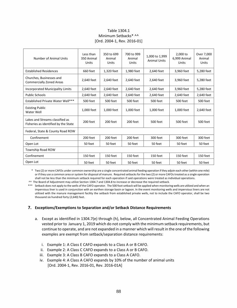
88
Table 1304.1 Minimum Setbacks* ^^
[Ord. 2004-1, Rev. 2016-01]
Number of Animal Units Less than
350 Animal Units
350 to 699 Animal Units
700 to 999 Animal Units
1,000 to 1,999 Animal Units
2,000 to 6,999 Animal
Units
Over 7,000 Animal Units
Established Residences 660 feet 1,320 feet 1,980 feet 2,640 feet 3,960 feet 5,280 feet
Churches, Businesses and Commercially Zoned Areas 2,640 feet 2,640 feet 2,640 feet 2,640 feet 3,960 feet 5,280 feet
Incorporated Municipality Limits 2,640 feet 2,640 feet 2,640 feet 2,640 feet 3,960 feet 5,280 feet
Public Schools 2,640 feet 2,640 feet 2,640 feet 2,640 feet 2,640 feet 2,640 feet
Established Private Water Well*** 500 feet 500 feet 500 feet 500 feet 500 feet 500 feet
Existing Public Water Well 1,000 feet 1,000 feet 1,000 feet 1,000 feet 1,000 feet 2,640 feet
Lakes and Streams classified as Fisheries as identified by the State 200 feet 200 feet 200 feet 500 feet 500 feet 500 feet
Federal, State & County Road ROW Confinement 200 feet 200 feet 200 feet 300 feet 300 feet 300 feet
Open Lot 50 feet 50 feet 50 feet 50 feet 50 feet 50 feet
Township Road ROW Confinement 150 feet 150 feet 150 feet 150 feet 150 feet 150 feet
Open Lot 50 feet 50 feet 50 feet 50 feet 50 feet 50 feet * Two (2) or more CAFOs under common ownership are a single concentrated animal feeding operation if they adjoin each other (within one mile)
or if they use a common area or system for disposal of manure. Required setbacks for the two (2) or more CAFOs treated as a single operation shall not be less than the minimum setback required for each operation if said operations were treated as individual operations.
^^ The Board of Adjustment may utilize Section 1304.7 and 1304.8 to increase or decrease the required setback. *** Setback does not apply to the wells of the CAFO operator. The 500 foot setback will be applied when monitoring wells are utilized and when an
impervious liner is used in conjunction with an earthen storage basin or lagoon. In the event monitoring wells and impervious liners are not utilized with the manure management facility the setback from established private wells, not to include the CAFO operator, shall be two thousand six hundred forty (2,640) feet.
7. Exceptions/Exemptions to Separation and/or Setback Distance Requirements
a. Except as identified in 1304.7(e) through (h), below, all Concentrated Animal Feeding Operations vested prior to January 1, 2019 which do not comply with the minimum setback requirements, but continue to operate, and are not expanded in a manner which will result in the one of the following examples are exempt from setback/separation distance requirements:
i. Example 1: A Class E CAFO expands to a Class A or B CAFO.
ii. Example 2: A Class C CAFO expands to a Class A or B CAFO. iii. Example 3: A Class B CAFO expands to a Class A CAFO. iv. Example 4: A Class A CAFO expands by 10% of the number of animal units
[Ord. 2004-1, Rev. 2016-01, Rev. 2016-01A]
89
b. A Concentrated Animal Feeding Operation structure which is expanded or constructed, if the title holder of the land benefiting from the distance separation requirement executes a written waiver with the title holder of the land where the structure is located, under such terms and conditions which the parties may negotiate. The written waiver becomes effective only upon the recording of the waiver in the office of the Register of Deeds in the county. The title holder of the land benefitting from the distance separation requirement is the residence, commercial enterprise, individual or individuals, governmental entity, religious institution, or educational institution from which separation is required. The waiver shall be binding upon the heirs, successors, and assigns of the title holder and shall pass with the land. [Ord. 2004-1, Rev. 2016-01]
c. A Concentrated Animal Feeding Operation structure which is constructed or expanded closer than the required setback/separation distance from the corporate limits of a city, if the incorporated community approves a written waiver. The written waiver becomes effective only after recording with the Register of Deeds. [Ord. 2004-1, Rev. 2016-01]
d. A Concentrated Animal Feeding Operation structure which existed prior to the creation of residence,
educational institution, commercial enterprise, religious institution, incorporated community, if the residence, educational institution, commercial enterprise or religious institution was constructed or expanded or the boundaries of the incorporated community were expanded, after the date that the concentrated animal feeding operation was established. The date that the Concentrated Animal feeding Operation was established is the date on which the Concentrated Animal Feeding Operation commenced operating. A change in ownership or expansion shall not change the date of operation. [Ord. 2004-1, Rev. 2016-01]
e. A non-standard Concentrated Animal Feeding Operation (Class E) with or without a county issued permit is exempt from setback/separation distance requirements in the event of a calamity. The buildings and use areas associated with the non-standard Concentrated Animal Feeding Operation are allowed to be replaced if the separation is equal to or greater than the distance between the Concentrated Animal Feeding Operation and other existing uses requiring a separation distance on June 9, 2016. A vested Class E Concentrated Animal Feeding Operation is allowed to expand to a maximum size of one thousand nine hundred ninety-nine (1,999) animal units, subject to receiving a conditional use permit. Any expansion is allowed without having to obtain a variance from setback/separation requirements, provided the separation distance between the structure or use associated with the proposed Concentrated Animal Feeding Operation expansion is equal to or greater than the distance between the Concentrated Animal Feeding Operation and other existing uses requiring a separation distance on June 9, 2016. The replacement and expansion provisions contained herein do not apply to Concentrated Animal Feeding Operations situated over the Aquifer Protection Overlay District. See Figure 1304.7. [Ord. 2016-01, Rev. 2016-01A]
f. A vested Concentrated Animal Feeding Operation (Class D) is exempt from setback/separation distance requirements. The vested Concentrated Animal Feeding Operation is allowed an expansion not to exceed a cumulative total of three hundred (300) animal units without having to obtain a variance from setback/separation requirements. The expansion is allowed, provided the separation distance between the structure or use associated with the proposed Concentrated Animal Feeding Operation replacement/expansion is equal to or greater than the distance between the Concentrated Animal Feeding Operation and other existing uses requiring a separation distance on June 9, 2016. The expansion also shall conform to Section 11.05.05. See Figure 1304.7. [Ord. 2016-01, Rev. 2016-01A]
90
g. A vested Concentrated Animal Feeding Operation (Class C) with a county issued permit is exempt from setback/separation distance requirements. In the event of a calamity, the buildings and use areas associated with the vested Concentrated Animal Feeding Operation are allowed to be replaced. The vested Concentrated Animal Feeding Operation is allowed to expand to a maximum size of one thousand nine hundred ninety-nine (1,999) animal units. The replacement and/or expansion is allowed without having to obtain a variance from setback/separation requirements. The replacement and/or expansion is allowed without having to obtain a variance from setback/separation requirements, provided the separation distance between the structure or use associated with the proposed Concentrated Animal Feeding Operation replacement/expansion is equal to or greater than the distance between the Concentrated Animal Feeding Operation and other existing uses requiring a separation distance on (the Adoption date of ordinance). The replacement and expansion provisions contained herein do not apply to vested Concentrated Animal Feeding Operations situated over the Aquifer Protection Overlay District. See Figure 1304.7. [Ord. 2016-01, Rev. 2016-01A]
h. A vested Concentrated Animal Feeding Operation (Class A or Class B) with a county issued permit is exempt from setback/separation distance requirements. In the event of a calamity, the buildings and use areas associated with the vested Concentrated Animal Feeding Operation are allowed to be replaced. The replacement is allowed without having to obtain a variance from setback/separation requirements, provided the separation distance between the structure or use associated with the proposed Concentrated Animal Feeding Operation replacement/expansion is equal to or greater than the distance between the Concentrated Animal Feeding Operation and other existing uses requiring a separation distance on (the Adoption date of ordinance). The replacement of said Concentrated Animal Feeding Operation cannot exceed the number of animal units identified in the existing County Permit, unless a new permit is granted in accordance with Section 1304.7.a.iii or Section 1304.7.a.iv. The replacement and expansion provisions contained herein do not apply to vested Concentrated Animal Feeding Operations situated over the Aquifer Protection Overlay District. See Figure 1304.7. [Ord. 2016-01, Rev. 2016-01A]
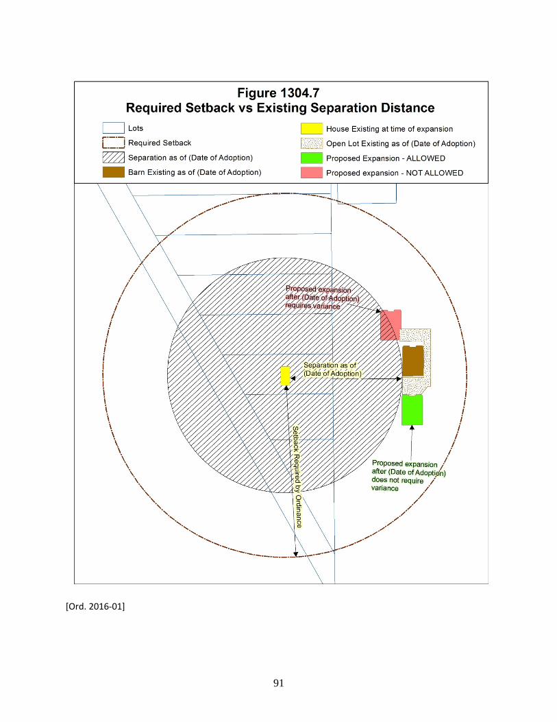
91
[Ord. 2016-01]
92
8. Additional Setback and Separation Distance Requirements for Class A, B, C, D, and E Concentrated Animal Feeding Operations. [Ord. 2004-1 unless otherwise noted]
Each application for a new or expanded Concentrated Animal Feeding Operation will be reviewed by the Board of Adjustment on a site-specific basis. The Board of Adjustment reserves the right to increase or decrease the minimum required setbacks and separation distance on a site specific review, based on one (1) or more of the following considerations. a. Considerations To Increase Setbacks And Separation Distances [Ord. 2004-1, Rev. 2016-01]
i. Existing Concentration - A Concentrated Animal Feeding Operation of two thousand (2,000) or
more animal units is proposed to be located in an area where a concentration of three thousand (3,000) animal units currently exists within one (1) mile of the proposed Concentrated Animal Feeding Operation site.
In the event the Board determines that a concentration of animal units already exists and an increase in animal units may pose air or water quality concerns, the Board may utilize the South Dakota Odor Footprint Tool or other instrument developed and/or accepted by South Dakota State University and the Board of Adjustment to determine the need to increase setback and/or separation requirements. The Board may further:
a) Apply the established minimum setback subject to 1304.8.a.ii
b) Increase the established minimum setback based upon 1304.8.a.ii
c) Amend and approve the request for less than two thousand (2,000) animal units based upon 1304.8.a.ii.
d) Deny the request
ii. Due to topography and prevailing wind direction, and/or concentration of animal units,
additional setback and separation distance is appropriate to safeguard air or water quality. The South Dakota Odor Footprint Tool or other instrument developed and/or accepted by South Dakota State University and the Board of Adjustment may be utilized to determine the need to increase setback and/or separation requirements. [Ord. 2004-1, Rev. 2016-01]
iii. Siting of a Concentrated Animal Feeding Operation is in excess of one thousand (1,000) animal units. [Ord. 2004-1, Rev. 2016-01]
In the event the Board determines that the siting of a CAFO, where one did not previously exist, with more than one thousand (1,000) animal units may pose air or water quality concerns, the Board may utilize the South Dakota Odor Footprint or other instrument developed and/or accepted by South Dakota State University and the Board of Adjustment to determine the need to increase setback and/or separation requirements. The Board may further:
a) Apply the established minimum setback subject to 1304.8.a.ii
b) Increase the established minimum setback based upon 1304.8.a.ii
93
c) Amend and approve the request for less than one thousand (1,000) animal units based upon 1304.8.a.ii
d) Deny the request
iv. Review of past management practices and proposed improvements to manure handling facilities.
b. Considerations To Decrease Setbacks and Separation Distances [Ord. 2004-1, Rev. 2016-01]
The Board of Adjustment may reduce minimum setback/separation distances of any new or existing Concentrated Animal Feeding Operation proposing to expand based upon any or all of the following considerations: i. Review of the operation of the Concentrated Animal Feeding Operation as it pertains to the type
of manure handling system and manure application methods to be used.
ii. Due to the type of manure handling and management of the CAFO little or no impact on adjacent property is expected. The use of Bio-filters, neoprene lagoon covers, and/or methane digesters are examples of improvements which may result in the reduction of recommended setbacks and separation distances. The South Dakota Odor Footprint Tool or other instrument developed and/or accepted by South Dakota State University and the Board of Adjustment may be utilized to determine the need to decrease setback and/or separation requirements.
iii. Due to topography and/or prevailing wind direction little or no impact on adjacent property is
expected. The South Dakota Odor Footprint Tool or other instrument developed and/or accepted by South Dakota State University and the Board of Adjustment may be utilized to determine the need to decrease setback and/or separation requirements.
iv. By limiting the proposed expansion to specific number of animal units no adverse impacts are
expected. The South Dakota Odor Footprint Tool or other instrument developed and/or accepted by South Dakota State University and the Board of Adjustment may be utilized to determine the need to decrease setback and/or separation requirements.
9. Manure Application Setbacks [Ord. 2004-1, Rev. 2004-1B, Rev. 2016-01]
a. Table 1304.2 provides the following manure application setbacks apply to all classes of Concentrated Animal Feeding Operations.
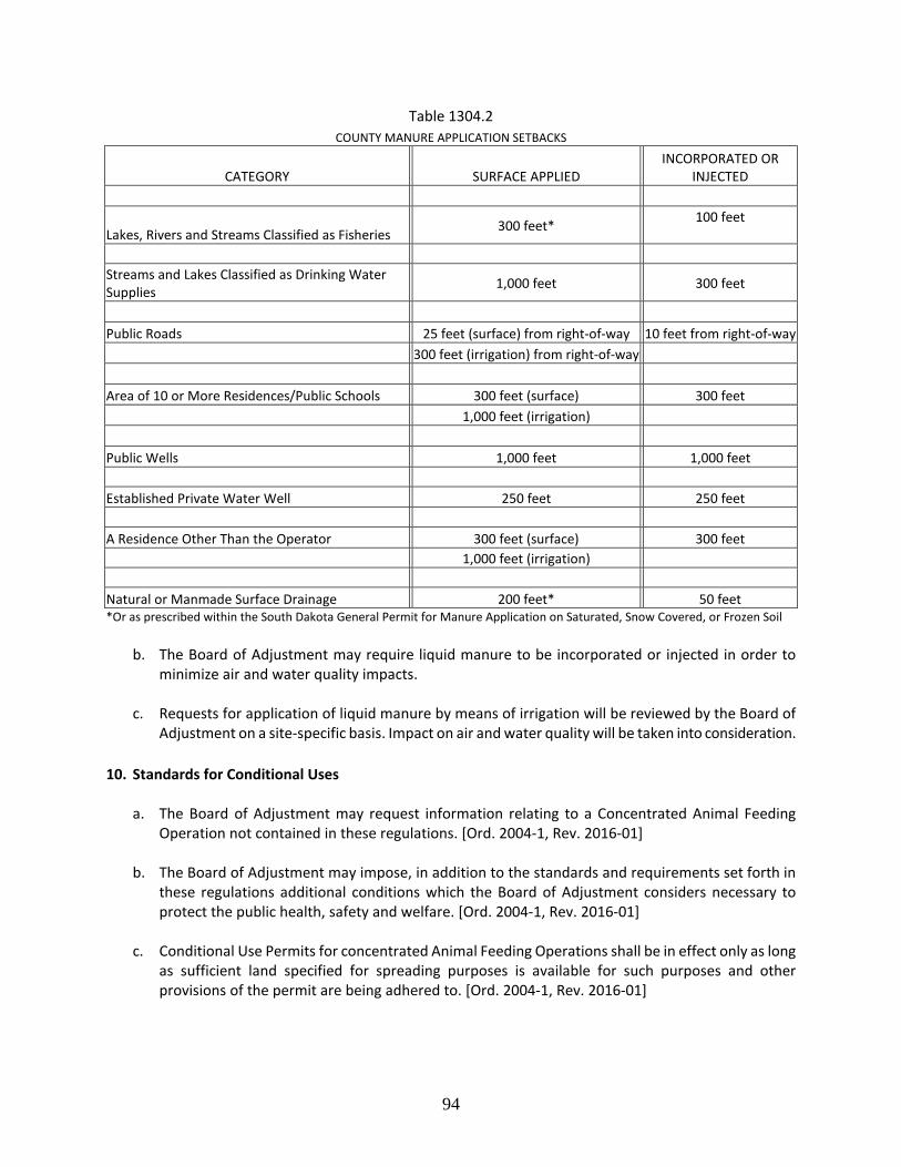
94
Table 1304.2 COUNTY MANURE APPLICATION SETBACKS
CATEGORY SURFACE APPLIED INCORPORATED OR
INJECTED
Lakes, Rivers and Streams Classified as Fisheries 300 feet* 100 feet
Streams and Lakes Classified as Drinking Water Supplies 1,000 feet 300 feet
Public Roads 25 feet (surface) from right-of-way 10 feet from right-of-way 300 feet (irrigation) from right-of-way Area of 10 or More Residences/Public Schools 300 feet (surface) 300 feet 1,000 feet (irrigation) Public Wells 1,000 feet 1,000 feet Established Private Water Well 250 feet 250 feet A Residence Other Than the Operator 300 feet (surface) 300 feet 1,000 feet (irrigation) Natural or Manmade Surface Drainage 200 feet* 50 feet *Or as prescribed within the South Dakota General Permit for Manure Application on Saturated, Snow Covered, or Frozen Soil
b. The Board of Adjustment may require liquid manure to be incorporated or injected in order to minimize air and water quality impacts.
c. Requests for application of liquid manure by means of irrigation will be reviewed by the Board of
Adjustment on a site-specific basis. Impact on air and water quality will be taken into consideration. 10. Standards for Conditional Uses
a. The Board of Adjustment may request information relating to a Concentrated Animal Feeding Operation not contained in these regulations. [Ord. 2004-1, Rev. 2016-01]
b. The Board of Adjustment may impose, in addition to the standards and requirements set forth in
these regulations additional conditions which the Board of Adjustment considers necessary to protect the public health, safety and welfare. [Ord. 2004-1, Rev. 2016-01]
c. Conditional Use Permits for concentrated Animal Feeding Operations shall be in effect only as long as sufficient land specified for spreading purposes is available for such purposes and other provisions of the permit are being adhered to. [Ord. 2004-1, Rev. 2016-01]
95
d. When considering an application, the Board of Adjustment will take into consideration current and past violations, documented by the Environmental Protection Agency, the South Dakota Department of Environment and Natural Resources, or similar applicable agency in other states, in relating to Concentrated Animal Feeding Operations that the applicant has or had an interest in. [Ord. 2004-1, Rev. 2016-01]
e. Conditional Use Permit applicants will be required to file a letter of assurances as required by the Board of Adjustment. Class E (with at least 500 animal units) Concentrated Animal feeding operations established after June 9, 2016 are required to sign the letter of assurance as provided in Section 1306.01. The letter of assurances will be prepared by the zoning officer and/or Board of Adjustment and signed by both the applicant and the Board of Adjustment’s designee. The permit for the concentrated animal feeding operation is based upon compliance with the regulations herein, and associated letter of assurances. Any violation of these regulations or non-compliance with the letter of assurances shall be cause for revoking a permit. If a violation of these regulations or non-compliance with the letter of assurance occurs, permit holders will be notified by registered mail and a hearing before the Board of Adjustment will be held concerning status of the permit. The Board of Adjustment shall either revoke the permit or set a time line for compliance. If compliance is not met, the permit shall be revoked and the permit holder ordered to cease operations. [Ord. 2004-1, Rev. 2016-01, Rev. 2016-01A]
11. The following information may be requested and reviewed by the Board of Adjustment prior to the
issuance or as a condition to the issuance of a conditional use permit for any class of CAFO. [Ord. 2004-1, Rev. 2016-01A]
a. Owner(s)/Applicant(s) name, address and telephone number. b. Legal descriptions of site and site plan. c. Number and type of animals.
d. Preliminary Nutrient Management Plan, if required.
e. Preliminary manure management and operation plan, if required.
f. Preliminary management plan for fly and odor control, if required.
g. Information on ability to meet suggested setbacks and separation distances
h. As a condition of approval of any Concentrated Animal Feeding Operation over 1,000 animal units or
as determined by the Board of Adjustment, the documentation of an approved General Permit from the South Dakota Department of Environment & Natural Resources for animal species is required. The issuance of a State General Permit satisfies the county’s requirements for an approved nutrient management plan and manure management plan.
i. Documentation of notice to public water supply officials.
j. Information on soils, shallow aquifers, designated wellhead protection areas, and 100-year
floodplain designation.
96
k. Documentation of notice to whomever maintains the access road (township, county and state).
l. Any other information as contained in the application and requested by the Zoning Officer.
Section 1305. Vesting of Concentrated Animal Feeding Operations [Ord. 2016-01, unless otherwise noted] 1. Grant County recognizes the vested right to utilize a property for the purpose of a concentrated animal
feeding operation if:
a. The owner or lawful agent was engaged in the operation of a concentrated animal feeding operation, with or without a county-issued permit on (Date of adoption of ordinance);
b. The concentrated animal feeding operation was determined to be a nonconforming use due to setback/separation requirements established by Grant County on November 1, 1997 and/or was determined to be a non-conforming use due to minimum lot area requirements established by Grant County on September 15 2004 and/or was determined to be a non-standard use due to setback/separation requirements established by Grant County on June 9, 2016.
c. The owner or lawful agent applies for a vested right claim, and applies for a zoning permit and signs a letter of assurance, if applicable, within two years after (Date of adoption of new ordinance).
2. Any person claiming to be the owner of a vested right to operate a concentrated animal feeding
operation as defined herein may file a vested right claim with the form of said claim to be submitted, reviewed and approved in a manner prescribed by the Board of County Commissioners. At a minimum, the claim shall set forth the size of the concentrated animal feeding operation, the legal description of the land upon which the concentrated animal feeding operation was located and the name and owner of the land on (date of adoption of ordinance). The claim shall be signed under oath, and shall be either from the claimant's own personal knowledge or on information and belief. The vested right shall be recorded with the title of the property.
3. If the owner or lawful agent fails to acquire vested rights within the prescribed time, then zoning regulations adopted on November 1, 1997 and subsequent amendments will apply to his property.
4. The granting of a vested right allows the owner or lawful agent the ability to use a property for the
purpose of a concentrated animal feeding operation in accordance with Section 1304.7.
5. The vested property right shall be considered abandoned and the vested property shall revert to a nonconforming land use status subject to Article IV of these Regulations if any of the following occur:
a. The property is not used as a Concentrated Animal Feeding Operation for a period of two (2) years.
b. The owner or lawful agent does not comply with the zoning permit and associated letter of
assurance.
c. The principle use of the property changes from agricultural use to a residential, commercial, industrial or public use. [Rev. 2016-01A]
97
Section 1306.01. Permitted Use Letter of Assurance. [Ord. 2016-01, Rev. 2016-01A] As a requirement of Section 1304.10.e, the following letter of assurance is to be signed by the applicant and Designee of the Grant County Board of Adjustment prior to the issuance of a Class E (with at least 500 animal units) Concentrated Animal Feeding Operation Permit. Prepared by: Grant County Zoning Officer Address Milbank, SD 57252
Permitted Use Letter of Assurance A Permit has been granted by the Grant County Zoning Officer to (Applicant Name) to operate a Class E Concentrated Animal Feeding Operation on property owned by (Applicant Name). Property Location: ________________ Standards and Conditions to be placed upon the Permit for a Class E Concentrated Animal Feeding Operation issued by the Grant County Zoning Officer on (date). 1. This Permit authorizes the use of the above described property for a Class E Concentrated Animal
Feeding Operation consisting of (number animal units and species of animal) 2. The Concentrated Animal Feeding Operation site will comply with all setback requirements found in
Article XIII, Section 1304.6 of the Grant County Zoning Ordinance. 3. The Concentrated Animal Feeding Operation will comply with all requirements of Section 1105 “Aquifer
Protection Overlay District” of the Grant County Zoning Ordinance. 4. The applicant shall comply with the South Dakota Department of Environment and Natural Resources or
Natural Resources Conservation Services Nutrient Management Plan and Manure Management Plan. 5. The applicant shall provide updated information regarding the Nutrient Management Plan and Manure
Management Plan upon request of the Zoning Officer. 6. The applicant shall comply with all manure application setbacks per found in Section 1304.9 of the Grant
County Zoning Ordinance.
7. The applicant shall provide and comply with a management plan for fly and odor control consistent Section 1304.5.
8. The applicant shall obtain a haul road agreement with the applicable road authority for construction and
maintenance of roads associated with the Concentrated Animal Feeding Operation. Unless otherwise agreed to between the Road Authority and the applicant, at Grant County requires, at a minimum, the applicant to abide by the haul road agreement terms found Grant County Resolution #2014-36.
98
9. The Permit is transferable. Subsequent owners/operators will be required to agree to the terms of this permit.
10. The applicant may be required to forfeit the Permit in the event there are either a. Violations of the Permit or other Grant County Zoning regulations or
b. Failure of the manure management facility.
11. Violation of the terms of this Permit will be determined by the Grant County Zoning Officer.
a. The first violation substantiated by the Zoning Officer of this Permit may result in a notification letter
stating the violation and a prescribed period of time to remove the violation. A second violation occurring within one (1) calendar year of the previous violation may result in a review of the validity of the Permit and potential revocation of said permit. A third violation within one (1) calendar year of the initial violation may result in revocation of the Permit and cessation of all CAFO operations within forty-five days (45) of notice of revocation.
b. The applicant may make appeal from the decision of the Zoning Officer or other agent of the Grant
County Board of Adjustment to the Grant County Board of Adjustment. The applicant shall file with the Zoning Officer a notice of appeal specifying the grounds thereof. The Zoning Officer shall forthwith transmit to the Board of Adjustment all papers constituting the record upon which the action appealed from was taken. Such appeal shall be taken within thirty (30) days. Appeals from the Board of Adjustment shall be taken to Circuit Court.
c. Failure to comply with the decision of the Zoning Officer or other agent of the Grant County Board of
Adjustment may be deemed a separate violation. IN WITNESS WHEREOF, Grant County and the Grantor(s) have executed this Letter of Assurance. _____________________________ ___________________ Applicant (Grantor) Date ____________________________ ___________________ Chairperson Date Grant County Board of Adjustment STATE OF SOUTH DAKOTA SS: COUNTY OF GRANT This instrument was acknowledged before me on ____________, 20__ by (Applicant), Grantor. IN WITNESS WHEREOF, I hereunto set my hand and official seal. _____________________________ Notary Public My Commission Expires: ____________________
99
STATE OF SOUTH DAKOTA SS: COUNTY OF GRANT This instrument was acknowledged before me on ____________, 20__ by ____, representing Grant County as the Chairperson of the Grant County Board of Adjustment. IN WITNESS WHEREOF, I hereunto set my hand and official seal. _____________________________ Notary Public My Commission Expires: ____________________