Embed Size (px)
Citation preview
BURLEIGH COUNTY
ZONING ORDINANCE
Includes all amendments through March 2018

ii
TABLE OF CONTENTS ARTICLE 1 PURPOSE, INTENT and AUTHORITY 1. Purpose -------------------------------------------------------------- 1 2. Intent ------------------------------------------------------------------ 2 3. Authority --------------------------------------------------------------- 2 ARTICLE 2 BURLEIGH COUNTY PLANNING COMMISSION 1. Formation ------------------------------------------------------------- 3 2. Membership --------------------------------------------------------- 3 3. Term of Members -------------------------------------------------- 3 4. Meeting-Officers-Compensation ------------------------------- 3 5. Duties ----------------------------------------------------------------- 3 6. Planning Commission Actions ---------------------------------- 4 7. Appeals ---------------------------------------------------------------- 4 ARTICLE 3 DEFINITIONS -------------------------------------------------- 6 ARTICLE 4 ZONING DISTRICTS and BOUNDARIES 1. Division of County into Districts -------------------------------- 25 2. Boundaries of District-Zoning Map ---------------------------- 25 3. Interpretation of District Boundaries -------------------------- 25 ARTICLE 5 GENERAL PROVISIONS and GUIDELINES 1. County Zoning Jurisdiction -------------------------------------- 27 2. County Subdivision Jurisdiction -------------------------------- 28 3. City Zoning & Subdivision Jurisdiction ----------------------- 28 4. Area and Yards ----------------------------------------------------- 28 5. Amendments -------------------------------------------------------- 28 ARTICLE 6 INCIDENTAL USES 1. Accessory Uses ---------------------------------------------------- 30 2. Home Occupation ------------------------------------------------- 32 ARTICLE 7 USE GROUPS 1. Purpose -------------------------------------------------------------- 34 2. Retail Group A ------------------------------------------------------ 34 3. Retail Group B ------------------------------------------------------ 35
iii
4. Service Group A ---------------------------------------------------- 35 5. Service Group B ---------------------------------------------------- 36 6. Office-Bank Group ------------------------------------------------- 37 7. Commercial Recreation Group --------------------------------- 37 8. Wholesale Group -------------------------------------------------- 38 9. Health and Medical Group --------------------------------------- 38 10. Education Group -------------------------------------------------- 39 11. Public Recreation Group ---------------------------------------- 39 12. Industrial Group --------------------------------------------------- 39
13. Utility Service Group --------------------------------------------- 41 14. Truck Farming Group -------------------------------------------- 42 15. General Farming Group ----------------------------------------- 43 16. Manufacturing Group -------------------------------------------- 43 ARTICLE 8 SPECIAL USES 1. General Provisions ------------------------------------------------ 46 1A. General Provisions-Animal Feeding Operations ---- 48 2. Airports --------------------------------------------------------------- 50 3. Cemeteries ---------------------------------------------------------- 51 4. Drive-In Theater ---------------------------------------------------- 52 5. Golf Driving Range ------------------------------------------------ 53 6. Tourist Campgrounds --------------------------------------------- 53 7. Salvage Yards ------------------------------------------------------ 54 8. Junkyards ------------------------------------------------------------ 54 9. Individual Mobile Homes ----------------------------------------- 55 10. Temporary Uses and Permits --------------------------------- 55 11. Moving of Buildings and Structures -------------------------- 57 12. Veterinary/Animal Clinic ----------------------------------------- 58 13. Veterinary/Animal Hospital/Enclosed Kennel -------------- 59 14. Solid Waste Disposal Facility ---------------------------------- 59 15. Adult Entertainment Centers ----------------------------------- 60 16. Vehicular Racetracks -------------------------------------------- 61 17. Rodeo or Rodeo Events ----------------------------------------- 61 18. Trap or Skeet Shooting Range -------------------------------- 61 19. Animal Feeding Operations ------------------------------------ 62 20. Asphalt Plants & Concrete Batch Plants ------------------- 64 21. Wind Turbine Facilities ------------------------------------------ 64 22. Roadway Maintenance Facilities ----------------------------- 78 23. Temporary Worker Housing ------------------------ ----------- 79 24. Meat Packing Facilities ------------------------------------------ 83 25. Limited Meat Packing Facilities ------------------------------- 84 26. Medical Marijuana Manufacturing or Distribution Center- 86
iv
ARTICLE 9 NON-CONFORMING USES 1. Definition ------------------------------------------------------------- 91 2. Expansion of Non-Conforming Uses ------------------------- 91 3. Additions, Repairs, Alterations --------------------------------- 91 4. Destruction ---------------------------------------------------------- 91 5. Moving Buildings --------------------------------------------------- 92 6. Change in Use of Property -------------------------------------- 92 7. Discontinuance ----------------------------------------------------- 92 8. Continuance --------------------------------------------------------- 92 ARTICLE 10 AUTOMOBILE PARKING 1. Off-Street Parking ------------------------------------------------- 93 2. Off-Street Loading ------------------------------------------------- 95 3. Continuing Character of Obligation --------------------------- 96 4. Fractional Measurements ---------------------------------------- 97 5. Location of Required Parking and Loading Facilities ---- 97 6. Plan of Required Off-Street Parking or Loading ----------- 97 7. Uses of Required Off-Street Parking By Another Building -------------------------------------------- 98 8. Maintenance of Public Off-Street Parking Places --------- 98 9. Collective Action Relative to Off-Street Parking and Loading 98 10. Mixed Uses --------------------------------------------------------- 98 11. Non-Conforming Uses ------------------------------------------- 98
ARTICLE 11 A AGRICULTURAL DISTRICT REGULATIONS 1. General Description ----------------------------------------------- 100 2. Definition of "FARM" ---------------------------------------------- 100 3. Uses Permitted ----------------------------------------------------- 100 4. Special Uses -------------------------------------------------------- 101 5. Accessory Uses ---------------------------------------------------- 102 6. Development Standards ----------------------------------------- 102 7. Additional Development Standards for Land Abutting the Missouri River ----------------------------------------------------- 103
ARTICLE 12 R1 COUNTRY HOMES RESIDENTIAL DISTRICT - REGULATIONS 1. General Description ----------------------------------------------- 104 2. Uses Permitted ----------------------------------------------------- 104 3. Density ---------------------------------------------------------------- 105 4. Lot Area -------------------------------------------------------------- 105 5. Front Yard ----------------------------------------------------------- 105 6. Side Yard ------------------------------------------------------------ 105 7. Rear Yard ------------------------------------------------------------ 105
v
8. Height Limits -------------------------------------------------------- 105 9. Automobile Parking ------------------------------------------------------- 106 10. Minimum Road Standards -------------------------------------- 106 11. Allowable Accessory Buildings -------------------------------- 106 12. Additional Development Standards for Land Abutting the Missouri River ---------------------------------------------------- 106 ARTICLE 13 R2 SINGLE FAMILY RESIDENTIAL DISTRICT REGULATIONS 1. General Description ----------------------------------------------- 108 2. Permitted Uses ----------------------------------------------------- 108 3. Special Uses --------------------------------------------------------- 108 4. Accessory Uses ----------------------------------------------------- 108 5. Development Standards ------------------------------------------ 109
ARTICLE 14 R3 SINGLE/TWO-FAMILY RESIDENTIAL DISTRICT REGULATIONS 1. General Description ----------------------------------------------- 110 2. Permitted Uses ----------------------------------------------------- 110 3. Special Uses -------------------------------------------------------- 110 4. Accessory Uses ---------------------------------------------------- 111 5. Development Standards ----------------------------------------- 111 6. Two-Family Building Standards -------------------------------- 112 ARTICLE 14.01 Repealed by Ordinance 13-09 ARTICLE 15 R5 MOBILE HOME PARK RESIDENTIAL DISTRICT REGULATIONS 1. General Description ----------------------------------------------- 114 2. Definition ------------------------------------------------------------- 114 3. Uses Permitted ----------------------------------------------------- 114 4. Density ---------------------------------------------------------------- 115 5. Lot Dimensions ----------------------------------------------------- 115 6. Lot Coverage -------------------------------------------------------- 115 7. Lot Restrictions ----------------------------------------------------- 115 8. Mobile Home Park Requirements ----------------------------- 115 9. Mobile Home Park Restrictions -------------------------------- 116 10. Mobile Home Parks, Plans and Layout --------------------- 117 11. Mobile Home Requirements ----------------------------------- 117 ARTICLE 16 C COMMERCIAL DISTRICT REGULATIONS 1. General Description ----------------------------------------------- 118
vi
2. Uses Permitted ----------------------------------------------------- 118 3. District Area --------------------------------------------------------- 119 4. Lot Area -------------------------------------------------------------- 119 5. District Width -------------------------------------------------------- 119 6. Floor Area Ratio ---------------------------------------------------- 119 7. Yard ------------------------------------------------------------------- 120 8. Height Limits -------------------------------------------------------- 120 9. Divided District ------------------------------------------------------ 120 10. Non-Conforming Uses ------------------------------------------- 120 11. Automobile Parking ----------------------------------------------- 120 ARTICLE 17 CM – Repealed by Ordinance 13-09 ARTICLE 18 I INDUSTRIAL DISTRICT REGULATIONS 1. General Description ----------------------------------------------- 122 2. Uses Permitted ----------------------------------------------------- 122 3. Special Use ---------------------------------------------------------- 123 4. Lot Area -------------------------------------------------------------- 123 5. Lot Width ------------------------------------------------------------- 123 6. Floor Area Ratio ---------------------------------------------------- 123 7. Front Yards ---------------------------------------------------------- 124 8. Side Yards ----------------------------------------------------------- 124 9. Rear Yards ---------------------------------------------------------- 124 10. Height Limits ------------------------------------------------------- 124 11. Automobile Parking ----------------------------------------------- 124 12. Landscaping -------------------------------------------------------- 124 ARTICLE 19 M – Repealed by Ordinance 13-09 ARTICLE 20 PUD PLANNED UNIT DEVELOPMENT DISTRICT REGULATIONS 1. Intent ------------------------------------------------------------------ 126 2. Application ----------------------------------------------------------- 126 3. Review and Approval --------------------------------------------- 127 4. Standards ------------------------------------------------------------ 128 5. Changes -------------------------------------------------------------- 128 6. Subdivision and Resale ------------------------------------------ 128 ARTICLE 20.1 P PUBLIC DISTRICT REGULATIONS 1. General Description ----------------------------------------------- 129 2. Uses Permitted ----------------------------------------------------- 129 3. Special Uses -------------------------------------------------------- 129 4. Development Standards ------------------------------------------ 130
vii
ARTICLE 21 FP FLOODPLAIN DISTRICT REGULATIONS 1. Statement of Purpose -------------------------------------------- 131 2. Methods of Reducing Flood Losses -------------------------- 131 3. Definitions ------------------------------------------------------------ 132 4. General Provisions ------------------------------------------------ 136 5. Administration ------------------------------------------------------- 138 6. Provisions for Flood Hazard Reduction ---------------------- 141 7. Appeal and Variance Procedures ----------------------------- 144 8. Penalties for Violation -------------------------------------------- 147 ARTICLE 22 PERMITS AND INSPECTIONS 1. Building Permits ---------------------------------------------------- 148 2. Permit Renewal ---------------------------------------------------- 148 3. Certificates of Occupancy --------------------------------------- 148 4. Enforcement --------------------------------------------------------- 148 5. No Electric Power without Proper Permits ------------------ 148 6. No Building Permit without a Plat ------------------------------ 149 7. No Building Permit without Approved Access -------------- 151 ARTICLE 23 BUILDING CONSTRUCTION REQUIREMENTS 1. Legislative Intent and Purpose --------------------------------- 152 2. Scope of Article ----------------------------------------------------- 152 3. Emergency Repairs ----------------------------------------------- 152 4. Standards ------------------------------------------------------------ 152 5. Adoption of the North Dakota State Building Code ------- 152 6. Definitions ------------------------------------------------------------ 153 7. Penalty for Violation ----------------------------------------------- 153 8. Amendments to the Code --------------------------------------- 153 9. Underground Utilities --------------------------------------------- 155 10. All Structures to Conform to Article 24 ---------------------- 155 ARTICLE 23.1 MECHANICAL CONSTRUCTION REQUIREMENTS 1. Adoption of the North Dakota State Building Code ------- 156 2. Amendments to the Code --------------------------------------- 156 3. Subsequent Editions ---------------------------------------------- 156 4. Conflicts -------------------------------------------------------------- 157 5. Qualifications and Licenses ------------------------------------- 157 6. Insurance ------------------------------------------------------------ 157 7. Exception ------------------------------------------------------------ 157 8. Permits; Exceptions ----------------------------------------------- 157
viii
9. Permit Application and Fees ---------------------------------- 157 10. Transfer Prohibited ---------------------------------------------- 158 ARTICLE 24 SANITATION REQUIREMENTS/PLUMBING IN GENERAL 1. Enforcement --------------------------------------------------------- 159 2. Defective Work, Installation ------------------------------------- 159 3. Application to Certain Work ------------------------------------- 159 4 through 10 (Reserved) 11. Licenses Required ------------------------------------------------ 160 12 through 15 (Reserved) 16. Permits Required ------------------------------------------------- 160 17. Permits - When Not Required --------------------------------- 160 18. Issuance of Permits ---------------------------------------------- 160 19. Permit Application and Fees ----------------------------------- 160 20. Use -------------------------------------------------------------------- 161 21 through 25 (Reserved) 26. Adoption ------------------------------------------------------------- 162 27. Subsequent Editions --------------------------------------------- 162 28. Conflicts ------------------------------------------------------------- 162 29. Definitions ----------------------------------------------------------- 162 30. Penalty for Violation ---------------------------------------------- 162 ARTICLE 25 SCHEDULE OF FEES 1. General Requirements ------------------------------------------- 163 2. Fees ------------------------------------------------------------------- 163 3. Other Fees ----------------------------------------------------------- 164 4. Crediting of Fees Collected ------------------------------------- 164 ARTICLE 26 BOARD OF APPEALS 1. County Commission to Act as Board of Appeals ---------- 165 2. Duties of Board of Appeals -------------------------------------- 165 ARTICLE 27 APPEAL PROCEDURE 1. Who May Take Action -------------------------------------------- 166 2. Petition ---------------------------------------------------------------- 166 3. Hearing --------------------------------------------------------------- 166 4. Rights and Powers ------------------------------------------------ 166 5. Appeals to District Court ----------------------------------------- 166
ix
ARTICLE 28 VARIANCES 1. Who May Take Action -------------------------------------------- 167 2. Hearing --------------------------------------------------------------- 167 3. Required Findings ------------------------------------------------- 167 ARTICLE 29 AMENDMENTS 1. Purpose -------------------------------------------------------------- 169 2. Initiation of Amendments ---------------------------------------- 169 3. Application for Amendment ------------------------------------- 169 4. Application Submission ------------------------------------------ 170 5. Preliminary Consideration by the Planning Commission 170 6. Public Hearing by the Planning Commission --------------- 170 7. Planning Commission Recommendation -------------------- 170 8. Board of County Commission Action ------------------------- 170 9. Withdrawal of Applications -------------------------------------- 170 10. Administrative Amendments ----------------------------------- 171 ARTICLE 30 ENFORCEMENT AND ADMINISTRATIVE LIABILITY 1. Enforcement --------------------------------------------------------- 172 2. Administrative Liability -------------------------------------------- 172 3. Accumulation of Certain Items Prohibited -------------------- 172 4. Violations Penalty for Disregarding ---------------------------- 173 ARTICLE 31 PENALTIES FOR VIOLATION 1. Complaints Regarding Violations ------------------------------ 174 2. Penalties for Violation -------------------------------------------- 174 ARTICLE 32 SEVERABILITY, REPEAL, EFFECTIVE DATE 1. Severability ---------------------------------------------------------- 175 2. Repeal ---------------------------------------------------------------- 175 3. Effective Date ------------------------------------------------------- 175 ARTICLE 33 SUBDIVISION REGULATIONS 1. Purpose of Subdivision Regulations -------------------------- 176 2. Planning Commission Review ---------------------------------- 176 3. Township Review -------------------------------------------------- 176 4. Definitions ------------------------------------------------------------ 176 5. Procedures ---------------------------------------------------------- 178 6. Design Standards -------------------------------------------------- 186 7. Waivers --------------------------------------------------------------- 193
x
8. Penalties ------------------------------------------------------------- 194 9. Undergrounding of Utilities -------------------------------------- 194 10. Soil Erosion Control ---------------------------------------------- 194 11. Plat Vacation Procedures --------------------------------------- 196 12. Minor Change to Existing Plats ------------------------------- 196 13. Storm Water Management ------------------------------------- 197 ARTICLE 34 MINIMUM HOUSING STANDARDS 1. Resolution ----------------------------------------------------------- 209 2. Inspection of Dwelling, Dwelling Units, Rooming Units and Premises ---------------------------------------------------- 209 3. Minimum Requirements for Dwelling ------------------------- 210 4. Responsibility of Owners and Occupants ------------------- 215 5. Duties of Occupants ---------------------------------------------- 216 6. Occupancy and Overcrowding --------------------------------- 216 7. Applicability of the County Building Code ------------------- 217 8. Substandard Building or Dwelling Units, Nuisances ------ 217 9. Duties of the Board of County Commissioners ------------ 218 10. Failure to Comply with the Decision of the Board of County Commissioners ------------------------------------ 219 11. Where Owner Absent from County --------------------------- 219 12. Emergency Action ------------------------------------------------ 219 13. Appeal --------------------------------------------------------------- 220 14. Violation, Penalty for Disregarding the Notice and Order 220

xi
This page intentionally left blank
ARTICLE 1 PURPOSE, INTENT AND AUTHORITY Section 1. Purpose For the purposes of promoting the health, safety, peace, morals, comfort, convenience, and general welfare, conserving the value of property throughout the County, reducing and avoiding congestion on public roads, streets, and highways; be it resolved by the Board of Burleigh County Commissioners:
1. To continue the previously established County Planning Commission.
2. To establish certain zoned areas in unincorporated areas of the County.
3. To secure the orderly development of the County as provided by Section 11-33 of the North Dakota Century Code.
4. To regulate and restrict the location, erection, construction, re-
construction, alteration, repair, or use of buildings, structures, and land; for industry, business, trade, residential and other uses (excepting, no provisions of this resolution shall in any way effect the use of land or buildings used for farming or any normal function incident thereto).
5. To regulate and restrict the height, number of stories, and size of all
buildings and the size of yards, courts, and other open spaces surrounding buildings.
6. To regulate and restrict the density of population.
7. To provide for the change of boundaries of zoned areas.
8. To provide references to zoning maps.
9. To provide regulations for the subdivision of land as provided by Section
11-33.2 of the North Dakota Century Code.
10. To provide minimum specifications for construction of buildings and sanitary facilities.
11. To provide minimum housing standards.
12. To provide for the enforcement of this Zoning Ordinance.
13. To prescribe penalties for the violation of regulations of this Zoning
Ordinance.
2
14. To provide for a Board of Appeals.
15. To provide for amendments to this Ordinance.
Section 2. Intent It is the intent of the Board of County Commissioners to promote the health, safety, and general welfare by guiding the development of the County, by means of a comprehensive land use plan which is in part carried out by the provisions of this Ordinance. It is the intent of this Ordinance to provide regulations, standards, and guides for the County's development which will:
1. Lessen congestion in the streets;
2. Secure safety from fire, panic, and other dangers;
3. Promote the health and general welfare;
4. Prevent the overcrowding of land;
5. Provide adequate light and air;
6. Avoid undue concentration of the population;
7. Facilitate adequate provision for: a. Transportation; b. Water distribution; c. Sewage disposal; d. Schools; e. Parks; and f. Other requirements.
Section 3. Authority For the purpose of promoting health, safety, morals, public convenience, general prosperity, and public welfare, the Board of County Commissioners is hereby empowered to regulate and restrict within the County, the location and the use of buildings and structures and the use, condition of use or occupancy of lands for residence, recreation, and other purposes (Section 11-33-01, NDCC). For the purpose of promoting health, safety, morals, public convenience, general prosperity, and public welfare, the Board of County Commissioners is hereby empowered to regulate and restrict within the County the subdivision of land (Section 11-33.2-02, NDCC).

3
ARTICLE 2 BURLEIGH COUNTY PLANNING AND ZONING COMMISSION Section 1. Formation There was created in 1959 a body known as the Burleigh County Planning & Zoning Commission, which Planning and Zoning Commission is actively serving the community at the time of adoption of these amended and revised ordinances and whose duties and functions are intended to be continued without change except as may hereinafter be declared. Section 2. Membership The Planning and Zoning Commission shall be composed of nine (9) members, two (2) of whom shall be appointed from the Board of County Commissioners, and two (2) from the governing body of the municipality designated as the county seat of the County to serve for their respective terms of elective office. The remaining five (5) members shall be appointed from the County at large. All appointments to the County Planning and Zoning Commission shall be made by the Board of County Commissioners (NDCC 11-33-04). Section 3. Terms of Members When appointments to said commission are first made, three (3) members-at-large shall be appointed for a two (2) year term, and two (2) members-at-large for a four (4) year term, after which all subsequent appointments for members-at-large shall be for a four (4) year term. Appointments to fill vacancies shall be for the unexpired portion of the term (NDCC 11-33-04). Section 4. Meetings, Officers and Compensation The Commission shall meet within thirty (30) days after its appointment and elect a chairman and other necessary officers from its membership. The Commission may adopt rules and by-laws not inconsistent with the provisions of this Article. A majority of the members of the Commission shall constitute a quorum. Members of the Commission may be compensated for their actual expenses in the same manner as members of the Board of County Commissioners. The County Auditor may appoint the Director of Planning to serve as secretary to the Commission and shall keep all of the records and accounts of the Commission. Section 5. Duties It is the duty of the Planning and Zoning Commission to:
4
1. Promote the public health, safety, peace, morals, comfort, convenience, general welfare and conservation of the value of property throughout the County.
2. Regulate and restrict the location, erection, construction, re-construction, alteration and use of buildings, structures and land uses for industrial, business trade, residential and other purposes, except as used for farming.
3. Require the Replatting of Lands
a. Deemed to be unsatisfactorily subdivided and/or becoming tax delinquent;
b. Which represent an obstacle to the orderly and efficient growth of the County;
c. For coordinated platting of adjacent small parcels of land.
4. Discourage the Subdivision of Land
a. That is far in advance of needs of the County; b. Which cannot be efficiently served by fire and police protection and
other services; c. Which is located in areas subject to flooding; d. Which is topographically unsuitable for development; e. Which official county soils and water studies reveal contain potential
difficulties or incompatibilities for development; f. Not having approval from the State Health Department.
Section 6. Planning and Zoning Commission Actions According to the procedures established for each particular request or application, the Planning and Zoning Commission may take the following actions: approve, approve and call for a public hearing, continue the public hearing, approve subject to certain stated conditions being met, deny, or table for further consideration and study. The Planning and Zoning Commission may also reconsider any action, provided such reconsideration is made prior to any required approvals by the Board of County Commissioners. Section 7. Appeals Any final decision of the Planning and Zoning Commission may be appealed to the Board of County Commissioners. Notice of appeal in writing shall be delivered to the County Auditor or the chairman of the Board of County Commissioners within ten (10) days after the Planning and Zoning Commission's decision. A meeting on the appeal shall be scheduled for the Board of County

5
Commissioners within forty-five (45) days of the receipt of the notice of appeal. After the appeal has been heard, the Board of County Commissioners shall make its decision.
6
ARTICLE 3 DEFINITIONS For the purposes of this Ordinance certain terms and words are hereby defined. Words used in the present tense shall include the future; the singular number shall include the plural the plural shall include the singular; the word "shall" is mandatory and not directory. Accessory Buildings - A subordinate building, the use of which is customarily incidental to that of the principal building on the same lot. Adult Bookstore - An enclosed building having as a substantial or significant portion of its stock in trade, books, magazines, or other periodicals which are distinguished or characterized by the emphasis on matter depicting or describing specific sexual activities or specified anatomical areas, for observation by patrons therein in return for payment of a consideration, irrespective of the numbers of patrons who may be able to view the presentation at one time. Adult Cinema - An enclosed building used on a regular basis for presenting pictorial materials or other visual images by way of direct or indirect projection, which materials are distinguished or characterized by an emphasis on the depiction of specified sexual activities or specified anatomical areas, for observation by patrons therein in return for payment of a consideration, irrespective of the numbers of patrons who may be able to view the presentation at one time. Adult Entertainment Center - An adult bookstore, adult cinema, or any establishment allowing any performance, entertainment or appearance, live or otherwise, of any specified anatomical areas or specified sexual activities on the premises, excluding licensed liquor premises.
(For the purposes of this ordinance, the following definitions shall apply to the foregoing terms:
Specified anatomical areas:
1. Less than completely and opaquely covered: a. Human genitals, pubic region; b. Buttocks; c. Female breast below a point immediately above the top of
the areola; and
2. Human male genitals in a discernibly turgid state, even if completely and opaquely covered.
7
Specified sexual activities:
1. Human genitals in a state of sexual stimulation or arousal;
2. Acts of human masturbation, sexual intercourse or sodomy;
3. Fondling of human genitals, pubic region, buttock or female breast.) Agriculture District - Shall include any lands or areas so designated A-Agricultural by the Board of County Commissioners under authority of this Ordinance. Alley - (Article 30): A strip of land, dedicated to public use, primarily to provide vehicular service access to the side or rear of properties otherwise abutting on a street. Animal Clinic - See "Veterinary". Animal Feeding Operation - A place where: 1) livestock have been, are, or will be confined, concentrated and fed for forty-five (45) or more days in any twelve (12) month period; 2) pasture, crops, or other vegetation are not normally managed or sustained for grazing during the normal growing season; and 3) animal waste or manure accumulates. All such operations containing one thousand (1,000) or more animal units shall be defined as an animal feeding operation. This term does not include an animal wintering operation. Adjoining animal feeding operations under common ownership are considered to be one animal feeding operation if they use common areas or systems for manure handling. An animal feeding operation in place and operating on the date this ordinance is effective September 5, 2001 shall be considered an existing animal feeding operation and shall not be subject to the requirements of this Ordinance unless it expands by any number of animal units. Animal Feeding Operation Operator - An individual or group of individuals, a partnership, a corporation, a joint venture, or any other entity owning or controlling one or more animal feeding operations or animal wintering operations. Animal Hospital - See "Veterinary". Animal Wintering Operation - The confinement of cattle or sheep used or kept for breeding purposes in a feedlot or sheltered area at any time between October 15 and May 15 of each production cycle under circumstances in which these animals do not obtain a majority of their feed and nutrients from grazing. The term includes the weaned offspring of cattle and sheep, but it does not include: 1) breeding operations of more than one thousand (1,000) animal units or 2) weaned offspring which are kept longer than one hundred-twenty (120) days and
8
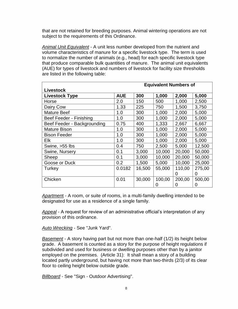
that are not retained for breeding purposes. Animal wintering operations are not subject to the requirements of this Ordinance. Animal Unit Equivalent - A unit less number developed from the nutrient and volume characteristics of manure for a specific livestock type. The term is used to normalize the number of animals (e.g., head) for each specific livestock type that produce comparable bulk quantities of manure. The animal unit equivalents (AUE) for types of livestock and numbers of livestock for facility size thresholds are listed in the following table:
Equivalent Numbers of Livestock
Livestock Type AUE 300 1,000 2,000 5,000
Horse 2.0 150 500 1,000 2,500
Dairy Cow 1.33 225 750 1,500 3,750
Mature Beef 1.0 300 1,000 2,000 5,000
Beef Feeder - Finishing 1.0 300 1,000 2,000 5,000
Beef Feeder - Backgrounding 0.75 400 1,333 2,667 6,667
Mature Bison 1.0 300 1,000 2,000 5,000
Bison Feeder 1.0 300 1,000 2,000 5,000
Elk 1.0 300 1,000 2,000 5,000
Swine, >55 lbs 0.4 750 2,500 5,000 12,500
Swine, Nursery 0.1 3,000 10,000 20,000 50,000
Sheep 0.1 3,000 10,000 20,000 50,000
Goose or Duck 0.2 1,500 5,000 10,000 25,000
Turkey 0.0182 16,500 55,000 110,000
275,000
Chicken 0.01 30,000 100,000
200,000
500,000
Apartment - A room, or suite of rooms, in a multi-family dwelling intended to be designated for use as a residence of a single family. Appeal - A request for review of an administrative official’s interpretation of any provision of this ordinance. Auto Wrecking - See "Junk Yard". Basement - A story having part but not more than one-half (1/2) its height below grade. A basement is counted as a story for the purpose of height regulations if subdivided and used for business or dwelling purposes other than by a janitor employed on the premises. (Article 31): It shall mean a story of a building located partly underground, but having not more than two-thirds (2/3) of its clear floor to ceiling height below outside grade. Billboard - See "Sign - Outdoor Advertising".
9
Block - The property abutting one side of a street and lying between the two (2) nearest intersecting streets, or between the nearest such street and railroad right-of-way, undivided acreage, river or live stream; or between any of the foregoing and any other barrier to the continuity of development. Board of Appeals – Board of County Commissioners of Burleigh County, North Dakota. Board of Commissioners - Board of County Commissioners of Burleigh County, North Dakota. Building - Any structure designed or intended for the support, enclosure, shelter or protection of persons, animals or property. When a structure is divided into separate parts by unpierced walls extending from the ground up, each part is deemed a separate building. Building, Height of - The vertical distance from the grade to the highest point of the coping of a flat roof or to the deck line of a mansard roof or to the mean height level between the eaves and ridge of gable, hip and gambrel roofs. Building Official - The Building Official of the County of Burleigh, North Dakota, or his authorized representative. Building Line - A line established, in general parallel to the front street line beyond which no part of a building shall project, except as otherwise provided by this resolution. Building, The Principal - A building in which is conducted the principal use of the lot on which it is located. Ceiling - (Article 31): Shall mean the interior overhead surface of a room. Cellar - (Article 31): Shall mean a story of a building located partly or wholly underground and having more than two-thirds (2/3) of its clear floor to ceiling height below outside grade. City - City of Bismarck, North Dakota. Commercial District - Any Commercial District. County - County of Burleigh, North Dakota.
10
County Health Officer – The County Health Officer shall mean the legally designated health authority of the County of Burleigh or authorized representative. Whenever the term "County Health Officer" is used hereafter in this Ordinance it shall be construed to also mean the "Building Official".
Decibel – A unit of sound measurement, abbreviated dB.
dB(A) - A frequency weighting that relates to the response of the
human ear. The weighted sound pressure level by the use of the A
metering characteristic and weighting specified in American National
Standards Institute (ANSI) Specification of Sound Level Meters.
Density - The number of families residing on, or dwelling units developed on, an
acre of land. As used in this article all densities are stated in families per net
acre, that is, per acre of land devoted to residential use, exclusive of land in
streets, alleys, parks, playgrounds, school yards, or other public lands and open
spaces.
District- A section or sections of unincorporated area of Burleigh County, North
Dakota, for which the regulations governing the use of buildings and premises or
the height and area of buildings are uniform.
Division - The division of a lot, tract or parcel of land, into lots or parcels of land for the purpose, whether immediate or future, of sale or of building development, including any plat or plan which includes the creation of any part of one or more streets, public easements, or other rights-of-way whether public or private, for access to or from such lots or parcels of land, and/or including the creation of new or enlarged parks, playgrounds, plaza or open spaces. "Subdivision" includes the re-subdivision of one or more lots as parcels of land in a subdivision made and recorded prior to or after the date these resolutions are adopted. However, the division of land for agricultural purposes into parcels of 40 or more acres, not involving any new street or easement of access, shall be exempted from this ordinance. Dwelling - A building or portion thereof arranged or designed to provide living facilities for one or more families. The term "dwelling" shall not be deemed to include a motel, hotel or tourist home. (Article 31): Shall mean any building, structure, mobile home, house trailer, or parts thereof used and occupied for human habitation, or intended to be so used, and includes appurtenances and utilities thereto or usually enjoyed therewith. Dwelling Group - In general, a building in which several unrelated individuals or families permanently reside, but in which individual cooking facilities are not provided for the individual persons or families. Specifically, "group-dwelling"
11
shall include rooming house, fraternity house, sorority house and private club in which one or more members have a permanent residence. "Group-dwelling" shall not be deemed to include a hotel, motel, tourist home, mobile home park or any use included in the "health-medical group". Dwelling-Multi-Family - A building containing two (2), three (3) or four (4) dwelling units. Dwelling-Single-Family - A building containing only one dwelling unit designed to be located on a permanent perimeter foundation and, if site built, constructed in accordance with the provisions of the applicable County codes governing construction; or, if manufactured off site, constructed in accordance with either the County codes governing construction or the HUD Manufactured Home Construction and Safety Standards Act of 1974 (24 CFR 3280). All single-family dwellings shall be considered and taxed as real property, as provided by law. Each single-family dwelling shall have a minimum overall front width of twenty-four (24) feet, minimum overall depth of twenty (20) feet, a minimum main floor living space square footage of nine hundred (900) square feet, and a minimum ceiling height of seven (7) feet, six (6) inches. A manufactured home that meets all of the requirements herein is classified as a single family dwelling. Dwelling-Two-Family - A building containing only two (2) dwelling units. Dwelling Unit - A building, or portion thereof, providing complete housekeeping facilities for one (1) family. (Article 31): Shall mean any room or group of rooms located within a building arranged for the use of one (1) or more individuals living together as a single housekeeping unit with facilities which are used or intended to be used for living, sleeping, cooking and eating purposes. Easement - A grant by the property owner of the use of a strip of land by the public, or by one or more persons or corporations for a specific purpose or purposes. Extermination - Shall mean the control and elimination of insects, rodents, or other pests by eliminating their harboring places; by depriving or making inaccessible materials that may serve as their food; by poisoning, spraying, fumigating, trapping, or any other recognized and legal pest elimination methods approved by the County Health Officer. Family - A group of one (1) or more persons occupying a premises and living as a single housekeeping unit as distinguished from a group occupying a boarding house, lodging house or hotel, as herein defined. (Article 31): Shall mean one or more persons occupying a dwelling or dwelling unit and living as a single nonprofit unit.
12
Farm - A zoned area of Burleigh County containing at least forty (40) acres, which is used for the growing of the usual farm products such as vegetables, fruit trees, and grain, and their storage on the area, as well as for raising thereon the usual farm poultry and farm animals, such as horses, cattle, sheep and swine. The term "farming" includes the operating of such an area for one or more of the above uses, including dairy farms with the necessary accessory uses for treating or storing the produce; provided however, that the operation of any accessory uses shall be secondary to that of the normal farming activities, and provided further that farming does not include the commercial feeding of garbage or offal to swine or other animals. Filling Station - Any building or premises used for the dispensing, sale or offering for sale at retail of any automobile fuels or oils. When the dispensing, sale or offering for sale is incidental to the conduct of a public garage, the premises are classified as a public garage. Floor Area Ratio - The floor area of a building, or buildings, on a zoning lot. A floor area of a building or buildings is the sum of the gross horizontal areas of the several floors of all buildings on the lot, measured from the exterior faces of exterior walls, or from the center line of walls separating two (2) buildings. Floor area shall include the area of basements when used for residential, commercial or industrial purposes, but need not include a basement or portion of a basement used for storage or the housing of mechanical or central heating or the basement apartment of a custodian in a multi-family dwelling, except that portion of said custodian's dwelling unit which is in excess of fifty percent (50%) of the total basement floor area. In calculating floor area, the following need not be included:
1. Attic space providing structural head room of less than 7 feet, 6 inches;
2. Uncovered steps;
3. Terraces, breezeways and open porches; and
4. Automobile parking space in basement or private garage, but not to exceed six hundred (600) square feet for single-family dwellings; eight hundred (800) square feet for a two-family dwelling; and two hundred (200) square feet per car space required by the provisions of this resolution for any other use.
Frontage - All the property on one side of the street or highway between two (2) intersecting streets or highways (crossing or terminating) measured along the line of the street or highway, or if the street or highway is dead-ended, then all of the property abutting on one side between an intersecting street or highway and the dead-end of the street or highway.
13
Garbage - (Article 31): Shall mean the animal and vegetable wastes resulting from handling, preparation, cooking and consumption of food. Garage, Private - An accessory building housing not more than three (3) motor-driven vehicles, the property of and for the use of the occupants of the lot on which the private garage is located. Garage, Public - Any building or premises used for equipment, repairing, hiring, selling or storing motor-driven vehicles. Group Dwelling - See "Dwelling - Group". Group-Use - See "Use Group". Habitable Room - (Article 31): Shall mean a room or enclosed floor space used or intended to be used for living, sleeping, cooking, or eating purposes. Height of Building - The vertical distance measured from the highest of the following three (3) levels:
1. Street curb level;
2. The established or mean street grade in case the curb is not constructed
or
3. The average finished ground level adjoining the building if it sets back from the street line to level of the highest point at the roof beams of flat roofs, or roofs inclining not more than one (1) inch to the foot, and to the mean height level of the top of the main plate and highest ridge for other roofs.
Height (of Turbine) - The vertical distance from the grade of the property as existed prior to construction to the highest point of a turbine rotor blade when in the upright position. Highway Primary - Any Designated Interstate or Federal Route, such as I-94 or US 83. Primary highways provide for rapid movements of relatively large traffic volumes between large land areas, major traffic generators and other arterials. Primary highways should have controlled access and are usually multi-lane roads with no parking. Highway Secondary - Any Designated State or County arterial route, such as Highway 1804 or County Highway 10. Secondary highways provide through
14
traffic movements between areas and links collectors with other arterials. Secondary highways usually have two to four lanes and may be divided or undivided roads, preferably with little or no parking, and limited access. Home Occupation - Any occupation or profession carried on by a member of the immediate family, residing on the premises; in connection with which there is used no sign other than a name plate not more than one (1) square foot in area or no display that will indicate from the exterior that the building is being utilized in whole or in part for any purpose other than that of a dwelling; in which no person is employed other than a domestic servant; and in which no mechanical equipment is used except such as is permissible for purely domestic or household purposes. Hotel - A building in which lodging with or without meals, is provided and offered to the public for compensation and is open to transient guests. Hotels include motels and automobile courts, but do not include group dwelling as defined herein. Improvements - Street grading and surfacing with or without curbs and gutters, sidewalks, crosswalks, water mains, sanitary and storm sewers, culverts, bridges, street, trees and other improvements as required by this Ordinance. Industrial District - Any I Industrial District Infestation - (Article 31): Shall mean the presence, within or around a dwelling of any insects, rodents or other pests. Junk Yard - The use of any area of any lot whether inside or outside a building, or the use of any portion of that half of any lot that adjoins any street, for the storage, keeping or abandonment of junk, including scrap metal, rags, paper or other scrap materials, used lumber, salvaged house wrecking and structural steel materials and equipment, or for the dismantling, demolition or abandonment of automobiles or other vehicles or machinery parts thereof. Kennel - Any building or lot on which three (3) or more dogs and cats at least four (4) months of age are kept, boarded or trained whether in special buildings or runways or not. Livestock - Any animal raised for food, raw materials or pleasure, including, but not limited to, beef and dairy cattle, bison, sheep, swine, poultry and horses. Livestock also include animals raised for pelts. Lot - The word "lot" when used alone shall mean, unless the context of the Article clearly indicates otherwise, a "zoning lot" as defined herein. Lot, Corner - A lot abutting upon two (2) or more streets at their intersection.
15
Lot, Depth - The mean horizontal distance between the front and rear lot lines. Lot, Double-Frontage - A lot having a frontage on two (2) non-intersecting streets, as distinguished from a corner lot. Lot Line, Rear - The lot line generally opposite or parallel to the front street line. Lot of Record - Land designated as a separate and distinct lot on a legally recorded subdivision platted pursuant to North Dakota Century Code Section 11-33.2. Lot, Zoning - A tract of land occupied or to be occupied by a principal building and its accessory buildings, together with such open spaces and yards as are required under the provisions of this resolution, having not less than the minimum area required by this resolution for a zoning lot in the district in which such land is situated, and having its principal frontage on a dedicated public right-of-way or a permanent, exclusive, non-obstructed access easement to a dedicated public right-of-way, not less than twenty (20) feet wide. A "zoning lot" need not necessarily coincide with a "lot of record" and may consist of:
1. a single lot of record; 2. a portion of a lot of record; or 3 a combination of complete lots of record, or complete lots of record
and portions of lots of record, or portions of lots of record. Manufactured Home - A factory built structure which is to be used as a place for human habitation, which is not constructed or equipped with a permanent hitch or other device allowing it to be moved other than to a permanent site, which does not have permanently attached to its body or frame any wheels or axles, and which bears a label certifying that it was built in compliance with the HUD Manufactured Home Construction and Safety Standards Act of 1974 (24 CFR 3280). Manufacturing District - Any M Manufacturing District. Manure - Fecal material and urine from livestock, as well as animal-housing wash water, bedding material, rainwater or snow melt that comes in contact with fecal material or urine. Master Plan - The comprehensive plan, or any portion thereof, made and adopted by the Planning Commission in accordance with the laws of the State of North Dakota and the regulations of the County of Burleigh indicating the general or specific locations recommended for streets, parks, public buildings, zoning districts and all other public improvements.
16
Meaning of Certain Words - (Article 31): Whenever the words "dwelling", "dwelling unit", "rooming house", "rooming unit" or "premises" are used in this Ordinance, they shall be construed as though they were followed by the words "or any part thereof". Whenever the masculine pronoun is used, it shall also mean the feminine pronoun. Meat Packing Facility - A facility for the slaughtering and processing of animals and the refining of their byproducts. A meat packing facility includes the preparation of meat products for intrastate or interstate commerce and retail sale, but does not include custom processing of an animal or meat products for the owner of the animal or of the meat products, provided all meat products derived from the custom operation are returned to the owner of the animal or of the meat products. Meat Packing Facility, Limited - A facility for the slaughtering and processing of animals and the refining of their byproducts, limited to 100 animal units per week. A limited meat packing facility includes the preparation of meat products for intrastate or interstate commerce and retail sale, but does not include custom processing of an animal or meat products for the owner of the animal or of the meat products, provided all meat products derived from the custom operation are returned to the owner of the animal or of the meat products. Mobile Home - A transportable, factory built home, designed to be used as a year-round residential dwelling and built prior to enactment of the HUD Manufactured Home Construction and Safety Standards Act of 1974 (24 CFR 3280). Mobile Home Park - A plat of ground under single ownership or management which has been planned and improved for the placement of at least twenty (20) mobile homes which are used for dwelling or sleeping purposes, regardless of whether or not a charge is made for such accommodations. Motor Vehicle Parts Salvage Yard - The use of not more than fifty (50) percent of the premises of a motor vehicles repair garage or a motor vehicle body repair shop for the storage of motor vehicles for dismantling and sale of used parts thereof. Non-Conforming Use - The use of a building or other structure or of a tract of land which does not conform to the use or regulations of this Ordinance for the district in which it is located, either at the effective date of this Ordinance, or as a result of subsequent amendments which may be incorporated into this Ordinance. Nonconforming Structure - A structure which does not conform to the regulations of this Ordinance for the district in which it is located, either at the effective date
17
of this Ordinance or as a result of subsequent amendments which may be incorporated into this Ordinance. Non-Participating Dwelling - A dwelling on a non-participating parcel. Non-Participating Parcel - A parcel of real estate that is not a participating parcel. Occupied Structure - A building in which people live, work or frequent. Occupant - (Article 31): Shall mean any person, over one (1) year of age, living, sleeping, cooking, eating in, or having actual possession of a dwelling or dwelling unit or rooming unit. Off-Street Parking Space - An off-street area for the parking of one (1) motor vehicle having all-weather surface, a width of not than ten (10) feet and a length of not less than twenty (20) feet, and shall have an easy access to a street or alley by a driveway having all-weather surface. Operator - (Article 31): Shall mean any person who has charge, care or control of a building or parts thereof, in which dwelling units or rooming units are let. Ordinary High Water Mark - The elevation of the Missouri River at a flow rate of 33,000 cubic feet per second. In areas where there are multiple channels, the ordinary high water mark is the landward extent of the floodway, as delineated on the Federal Emergency Management Agency’s Flood Boundary and Floodway Map for Burleigh County.
Owner - (Article 31): Shall mean any person who alone, jointly or severally with others:
1. Shall have legal title to any dwelling or dwelling unit, with or without accompanying actual possession thereof; or
2. Shall have charge, care, or control of any dwelling or dwelling unit, as owner or agent as an executor, , administrator, trustee or guardian of the estate of the owner. Any such person thus representing the actual owner shall be bound to comply with the provisions of this ordinance, and of the rules and regulations adopted pursuant thereto, to the same extent as if he were the owner.
Parcel - A tract of land created by any means other than a subdivision platted pursuant to North Dakota Century Code Section 11-33.2. Parcel of Record - A parcel that existed as a separate and unique legal description prior to October 4, 2010. For property not under the County’s
18
jurisdiction on October 4, 2010, a parcel that existed as a separate and unique legal description prior to coming under the County’s jurisdiction. Participating Dwelling - A dwelling on a participating parcel. Participating Parcel - A parcel of real estate on which any turbine of the wind turbine facility will be constructed, or for which a participation agreement has been executed. Person - (Article 31): Shall mean and include any individual, firm, corporation, association, or partnership. Planning and Zoning Commission - The Planning and Zoning Commission of the County of Burleigh, North Dakota. Plumbing - (Article 31): Shall mean and include all of the following supplied facilities and equipment: gas pipes, gas-burning equipment, water pipes, water closets, sinks, installed dishwashers, lavatories, bath tubs, shower baths, installed clothes-washing machines, catch basins, drains, vents, and any other similar supplied fixtures, together with all connections to water, sewer, or gas lines. Repair - (Article 31): Shall mean to restore to good condition. Residential District - Any R1 Residential District. Road-Local - Roadway whose primary function is to provide access to abutting property. Local roads are usually two-lane roads with parking and direct access to adjacent lands. Road-Collector - Roadway which provides traffic movements between local roads and arterial roads and highways and also provides direct access to abutting property. Collector roads are usually two-lane roads that should be designed to minimize on-street parking and direct driveway access. Rooming House - A dwelling in which rooms are let for hire or persons are given lodging for compensation. Row Housing - A building which has not less than three (3) or more than six (6) one-family units and erected in a row as a single building on adjoining lots, each being separated from the adjoining unit or units by an approved masonry party wall or walls extended from the basement or cellar floor to the roof along the dividing lot line; and each such building being separated from any other building by space on all sides.
19
Rubbish - (Article 31): Shall mean combustible and non-combustible materials, except garbage, and the terms shall include the residue from the burning of wood, coke, and other combustible materials, rags, cartons, boxes, wood excelsior, rubber, leather, tree branches, yard trimmings, tin cans, metals, glass, crockery and dust. Salvage Yard - A place where used parts of automobiles or other equipment are collected and processed for resale. Sign - Any device for visual communication which is used for the purpose of bringing the subject thereof to the attention of the public, but not including any flag, badge or insignia of any governmental agency, or of any civic, charitable, religious, patriotic, fraternal, or similar organization. Sign-Outdoor Advertising - Sign, including billboard, which directs attention to a business, commodity, service, entertainment or other activity conducted, sold or offered elsewhere than on the premises upon which the sign is located. Sound Pressure Level (SPL) - The physical intensity of sound. Stabilized Bank - A river bank that has been stabilized by the Corps of Engineers or under a Corps of Engineers’ permit for bank stabilization. If the plans and specifications for the permitted structure were not approved by the Corps of Engineers, or if the structure was not built in accordance with the Corps approved plans and specifications, certification from a registered professional engineer will be required. Stable-Private - A detached accessory building for the housing of horses, ponies or mules owned by the occupants of the premises and not kept for remuneration, exhibition, hire or sale. Stable-Riding - A structure in which horses, ponies or mules used exclusively for pleasure riding or driving are housed, boarded, or kept for hire, including riding tracks or academies. Steep Slope - Land where agricultural activity or development is either not recommended or described as poorly suited due to slope steepness and the site’s soil characteristics, as mapped and described in the Burleigh County Soil Survey or other technical report. Where specific information is not available, steep slopes are defined as lands having an average slope over 12 percent (12%), as measured over horizontal distances of fifty (50) feet or more, that are not bluffs. Storage Unit Building (Personal Self-Serve) – A storage building that houses individual storage units for personal affects that are either rented or individually owned.
20
Storm Water Management - An implemented set of public policies and/or activities undertaken to regulate the impacts and/or benefits associated with storm water runoff under various specified conditions. Storm water management is primarily concerned with preventing and/or limiting flood damages and environmental impacts associated with rural property development. Storm Water Management Plan - A plan developed by a registered professional engineer employed by the owner/developer to manage storm water runoff for a particular project, subdivision development and/or drainage area. Storm Water Management System - Natural and/or constructed facilities that collect, store, convey, and/or treat storm water runoff. These facilities normally include detention and/or retention facilities, streets, roadway ditches, storm sewers, inlets and open channels. Story - That portion of a building, other than a cellar included between the surface of any floor and the surface of the floor next above it, or if there be no floor above it, then the space between the floor and the ceiling next above it. Story-Half - A space under a sloping roof which has the line of intersection of the roof decking and wall face not more than three (3) feet above the top floor level, and in which space not more than two-thirds (2/3) of the floor area is finished off for use. A half-story containing independent apartment or living quarters shall be counted as a full story. Street - A public thoroughfare which affords principal means of access to abutting property. Street Line - A dividing line between a lot, tract or parcel of land and a contiguous street. Structure - Anything constructed or erected, the use of which requires permanent location on the ground or attached to something having a permanent location on the ground. Structural Alterations - Any change in the supporting members of a building, such as bearing walls or partitions, columns, beams or girders, or any substantial change in the roof or in the exterior walls. Subdivision - (Article 30): The division of a lot, tract or parcel of land into lots for the purpose, whether immediate or future, of sales or building development, including any plat or plan which includes the creation of any part or one or more streets, public easements, or other rights-of-way, whether public or private, for access to or from such lots, and/or including the creation of new or enlarged parks, playgrounds, plazas or open spaces. "Subdivision" includes the re-

21
subdivision of one or more lots in a subdivision made and recorded prior to or after the date these regulations are adopted. However, the division of land for agricultural purposes into parcels of forty (40) or more acres, not involving any new street or easement of access, shall be exempted from these regulations. Substandard - (Article 31): Shall mean any dwelling, dwelling unit, or premises violating any provisions of this Ordinance. Supplied - (Article 31): Shall mean paid for, furnished, or provided by or under the control of the owner or operator. Surface Water - Waters of the state located on the ground surface, such as lakes, reservoirs, rivers and creeks. Temporary Housing - (Article 31): Shall mean any tent, trailer, or other structure used for human shelter which is designed to be transportable and which is not attached to the ground, to another structure, or to any utilities system and located on the same premises for more than thirty (30) consecutive days. Temporary Structure - A structure such as a tent or a building of sectional construction whose design and construction is such that it will be used only for a short period of time or that it can be readily moved to another location. Temporary Worker Housing – A group dwelling facility located in one or more buildings that are occupied on a temporary basis by workers that are not from the immediate area but are employed in the area for a specific purposes (such as oil exploration/drilling and related activities, construction projects or similar activities) and for a defined period of time. Temporary worker housing does not include a mobile home, a mobile home park, a manufactured home, a tourist camp, a tourist campground, a tourist home, a trailer or a trailer camp as defined and regulated herein. Temporary worker housing is also referred to as crew camp housing, temporary modular housing and man camps. Temporary Limited Worker Housing, – Temporary worker housing for twenty (20) or fewer workers and for a time period of six (6) months or less that is located on the same property as the activity at which the workers are employed. Limited temporary worker housing may include the use of recreational vehicles/trailers. Tourist Camp - An area containing one (1) or more structures designed or intended primarily for automobile transients or provided spaces where two (2) or more tents can be erected. Tourist Home - A dwelling in which sleeping accommodations in less than ten (10) rooms are provided or offered for transient guests for compensation. Any dwelling in which such accommodations for transient guests are offered in ten (10) or more rooms shall be deemed to be a "hotel" as defined herein. The use
22
of a dwelling as a tourist home shall not be considered an accessory use nor a customary home occupation. Trailer - Any vehicle or structure, including but not limited to an automobile trailer and trailer coach, mounted on wheels for use on highways and streets; propelled or drawn by its own or other motor power; and designed and constructed to provide for living or sleeping quarters for one (1) or more persons or for the conduct of a business, profession, trade or occupation, or use as a selling or advertising device. If wheels of a trailer are removed, except for repair it is deemed to be a building subject to all the regulations therefore. Trailer Camp - A tract of land, together with open spaces required by this or any other regulation, used, designed, maintained, or held out to accommodate ten (10) or more trailers, including all buildings, structures, tents, vehicles, accessories, appurtenances used or intended as equipment for such trailer camp, whether or not a charge is made for the use of the camp or its facilities. A trailer camp does not include automobile or trailer sales lots on which unoccupied trailers are parked for inspection or sale. Use - The term referring to:
1. Any purpose for which buildings, other structures or land may be arranged, designed, intended, maintained or occupied; and
2. Any occupation, business activity or operation carried on (or intended to be carried on) in a building or other structure or on land; or
3. A name of a building, or structure or tract of land which indicated the purpose for which it is arranged, designed, intended, maintained or occupied.
Used - Designed, intended or arranged to be used. Use Group - Two (2) or more uses similar in physical characteristics, traffic generation, location, utility, governmental service requirements, or generally compatible with other uses in a use group. Members the several use groups herein established are specifically listed in Article 7. Uses Permitted - Any use permitted by the regulations of this Ordinance. The term "permitted use" or its equivalent shall not be deemed to include any non-conforming use. Variance - A grant of relief from the literal provisions of this Ordinance in situations where strict adherence would cause practical difficulty or unnecessary hardship because of circumstances unique to the property.
23
Veterinary/Animal Clinic - A facility in which the practice conducted is essentially an out-patient type of practice for animals performed by licensed veterinarians. Veterinary/Animal Hospital - A facility in which the practice conducted includes the confinement as well as the treatment of animal patients by licensed veterinarians. Waiver - A minimum easing of the literal provisions of the subdivision regulations in situations where strict adherence would result in practical difficulty or unnecessary hardship because of circumstances unique to the property being subdivided. Waters of the State - All waters within the jurisdiction of the State of North Dakota, including all streams, lakes, ponds, impounding reservoirs, marshes, watercourses, waterways, and all other bodies or accumulations of water on or under the surface of the earth, natural or artificial, public or private, situated wholly or partly within or bordering upon the state, except those private waters that do not combine or effect a junction with natural surface or underground waters defined. Wind Turbine Facility - One or more wind turbines, including appurtenant structures and facilities, rated at an individual or combined nameplate capacity of 150 kilowatts or greater Yard - An open space of uniform width or depth on the same zoning lot with a building or group of buildings, which open space lies between the buildings or group of buildings and the nearest lot line and is unoccupied and unobstructed, from the ground upward except as may be specifically provided in this article. In measuring a yard, the line of a building shall be deemed to mean a line parallel to the nearest lot line drawn through the point of a building or group of buildings nearest to such lot line, exclusive of such features specified as not to be considered in measuring yard dimension or as being permitted to extend into a yard, and said measurements shall be taken at right angles from the line of the building to the nearest lot line. Yard-Front - A yard extending across the front of a lot between the side yard lines and being the minimum horizontal distance between the street line and any building or any projection thereof, other than the projection of the usual steps or entrance-way. Yard-Rear - A yard extending across the rear of a lot between the side lot lines and being the minimum horizontal distance between the rear lot and the rear of any building or any projection other than steps. On corner lots the rear yard shall be considered as parallel to the street upon which the lot has its least dimension. On both corner lots and interior lots, the rear yard shall in all cases be at the opposite end of the lot from the front yard.

24
Yard-Side - A yard extending from the front lot line to the rear yard line, and being the minimum horizontal distance between the side lot and the side of any building or any projections thereof.
25
ARTICLE 4 ZONING DISTRICTS AND BOUNDARIES Section 1. Division of County into Districts For the purposes of these regulations, and only for those portions of Burleigh County which are subject to the zoning provisions of this Ordinance, the County is hereby divided into thirteen (13) classes of districts, which are established as follows
1. A Agricultural - Article 11 2. R1 Residential - Article 12 3. R2 Residential - Article 13 4. R3 Residential - Article 14 5. R5 Residential - Article 15 6. C Commercial - Article 16 7. Article 17 Repealed by Ordinance 13-09 8. I Industrial - Article 18 9. Article 19 Repealed by Ordinance 13-09 10. PUD Planned Unit Development - Article 20 11. P Public Use - Article 20.1 12. FP Floodplain - Article 21
Effective with the date of the resolution which originally established this Ordinance, all unincorporated lands within the Townships listed in Article 5, Section 1, shall be classified as Agricultural, and shall remain so classified until, if, and when parcels of said land may be rezoned through proper procedures. No part of this Ordinance shall be construed as prohibiting or restricting the use of any lands or buildings used for farming purposes or any normal incidents thereto. Section 2. Boundaries of Districts and Zoning Map The location and boundaries of all zoning districts established in the County shall be shown on the official zoning map of the County. This map is titled ZONING MAP OF BURLEIGH COUNTY, NORTH DAKOTA, and is on file in the office of the County Auditor, County Building Official and County Planner. This map is hereby made a part of this Article. The County Planner is authorized and directed to make all necessary changes upon the official zoning map of the County in accordance with approved zoning changes as they are from time to time enacted by the Burleigh County Board of Commissioners. Section 3. Interpretation of District Boundaries Where uncertainties exist as to the boundaries of the various districts as shown
26
on the zoning map accompanying and made a part of this Article, the following rules shall apply:
1. District boundary lines are intended to follow street, road, or property lines, unless such district boundary lines are fixed by dimensions as shown on the zoning map.
2. Where district boundaries are indicated as approximately following street
or road lines, or proposed street or road lines, said lines shall be construed to be such boundaries.
3. Any street, road, railroad right-of-way, water course, channel, or body of
water, included on the zoning map shall, unless otherwise indicated, be included within the zoning district of adjoining property on either side thereof. Where such street, road, right-of-way, water course, channel or body of water, serves as a boundary between two (2) or more different zoning districts, a line midway in such street, road, right-of-way, water course, channel or body of water, and extending in the general direction of the long dimension thereof shall be considered the boundary between zoning districts.
27
ARTICLE 5 GENERAL PROVISIONS AND GUIDELINES
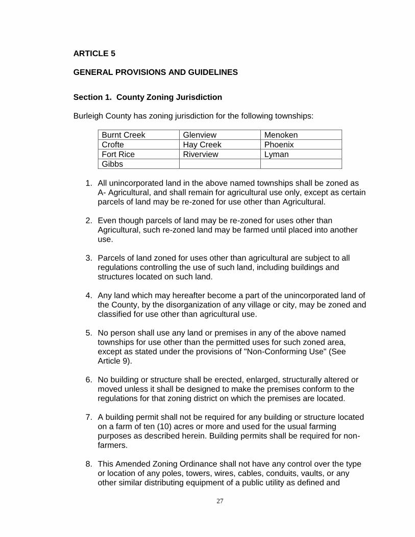
Section 1. County Zoning Jurisdiction Burleigh County has zoning jurisdiction for the following townships:
Burnt Creek Glenview Menoken
Crofte Hay Creek Phoenix
Fort Rice Riverview Lyman
Gibbs
1. All unincorporated land in the above named townships shall be zoned as
A- Agricultural, and shall remain for agricultural use only, except as certain parcels of land may be re-zoned for use other than Agricultural.
2. Even though parcels of land may be re-zoned for uses other than
Agricultural, such re-zoned land may be farmed until placed into another use.
3. Parcels of land zoned for uses other than agricultural are subject to all
regulations controlling the use of such land, including buildings and structures located on such land.
4. Any land which may hereafter become a part of the unincorporated land of
the County, by the disorganization of any village or city, may be zoned and classified for use other than agricultural use.
5. No person shall use any land or premises in any of the above named
townships for use other than the permitted uses for such zoned area, except as stated under the provisions of "Non-Conforming Use" (See Article 9).
6. No building or structure shall be erected, enlarged, structurally altered or
moved unless it shall be designed to make the premises conform to the regulations for that zoning district on which the premises are located.
7. A building permit shall not be required for any building or structure located
on a farm of ten (10) acres or more and used for the usual farming purposes as described herein. Building permits shall be required for non-farmers.
8. This Amended Zoning Ordinance shall not have any control over the type
or location of any poles, towers, wires, cables, conduits, vaults, or any other similar distributing equipment of a public utility as defined and

28
regulated by existing state laws.
Section 2. County Subdivision Jurisdiction Subdivision of all land not within the corporate limits or within the area of application of extraterritorial zoning jurisdiction of any city within the County shall be governed by Burleigh County in as far as its jurisdiction allows under Section 11-33.2 of the North Dakota Century Code and in accordance with the provisions of Article 33 of these regulations. Section 3. City Zoning and Subdivision Jurisdiction Subdivision and zoning of all land within the corporate limits or within the area of application of extraterritorial zoning jurisdiction of any city within the County shall be governed by the regulations of that city. Section 4. Area and Yards
1. No building or structure shall be erected; nor shall any existing building or structure be altered, enlarged or rebuilt; nor shall any open space surrounding any building be encroached upon or reduced in any manner except in conformity with the yard, lot, area, and building location regulations hereinafter designated for the district in which such building or open space is located.
2. No yard or other open space provided about any building, for the purpose
of complying with the provisions of these regulations, shall be considered as yard or open space for any other building; and no yard or other open space on one lot shall be considered as a yard or open space for a building on any other lot.
3. All yards required by these regulations shall be open and unobstructed to
the sky, except as hereinafter provided. AMENDMENTS October 5, 1971 MENOKEN Township officially relinquished their zoning
rights to Burleigh County. March 7, 1971 MENOKEN Township map showing specified zoning (in
color) was reviewed and filed with Register of Deeds.
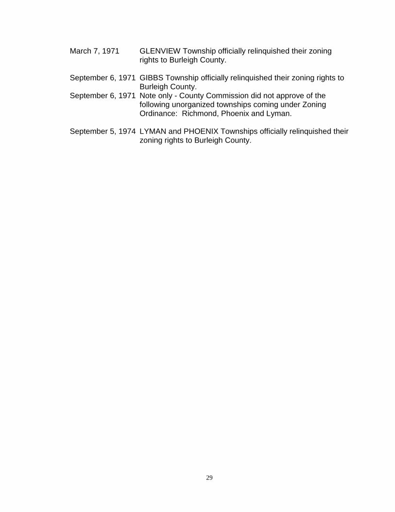
29
March 7, 1971 GLENVIEW Township officially relinquished their zoning rights to Burleigh County.
September 6, 1971 GIBBS Township officially relinquished their zoning rights to
Burleigh County. September 6, 1971 Note only - County Commission did not approve of the
following unorganized townships coming under Zoning Ordinance: Richmond, Phoenix and Lyman.
September 5, 1974 LYMAN and PHOENIX Townships officially relinquished their
zoning rights to Burleigh County.
30
ARTICLE 6 INCIDENTAL USES The uses of land and buildings permitted in the several districts established by this Article are designated by listing the principal uses permitted. In addition to such principal uses, it is the intent of this Ordinance, and this Article, to permit in each district those uses customarily incidental to any principal use permitted in the district. Such permitted incidental uses are specifically listed as follows, and any listed use is permitted on the same lot with the principal use to which it is incidental. Section 1. Accessory Uses
1. Dwelling Premises
a. Private garages or off-street parking spaces incidental to a dwelling.
b. Private greenhouse, vegetable, fruit, or flower garden, from which no products are sold or offered for sale.
c. Children's playhouse, and playground equipment.
d. Shed, tool room for storage of equipment used in grounds or
building maintenance but not including stable, chicken house, or other buildings to house agricultural livestock.
e. Private swimming pool and bath house.
f. Statuary, trellises, barbecue stove or similar ornamental or
landscaping features.
g. No more than three (3) dogs four months of age or older.
h. All allowable accessory buildings to a residence shall be limited to a maximum of four percent (4%) of the area of the parcel, a maximum wall height of sixteen and one-half (16½) feet and a maximum building height of twenty-five (25) feet.
i. Accessory buildings for the above computations shall include the following:
1. buildings: barns, stables, storage buildings, and detached garages. Attached garages are not included in the above computations, provided the area occupied by an
31
attached garage does not exceed one and one-half times the area of the footprint of the dwelling portion of the principal structure to which it is attached.
j Construction of a garage or storage building in any R1 or A district is allowed prior to the construction of the principal dwelling provided the following conditions are met: i. A petition waving any objection to the proposed outbuilding is signed by sixty percent (60%) of all owners of land within one-quarter (1/4) mile of the request ii Limitation of the garage or shed constructed pursuant to this section to one structure of no more than one thousand-two hundred (1,200) square feet for lots less than ten (10) acres in size, one thousand-eight hundred (1,800) square feet for lots between ten (10) and thirty-four (34) acres, and two-thousand four hundred (2,400) square feet for lots over thirty-four (34) acres in size.
2. Church a. Parish house, together with any use accessory to a dwelling as herein listed.
b. Religious education building.
c. Bulletin board not to exceed twenty (20) square feet in area.
d. Off-street parking lot for the use without charge of members and visitors to the church.
3 Health-Medical Group a. Any use accessory to a dwelling.
b. Off-street parking lot for the use without charge of staff members or visitors. c. Private garage. d. Nun's home, nurses' quarters. e. Laundry incidental to hospital.
32
4 Office-bank, Retail, Commercial Recreation Groups
a. Storage of customer, client, or operator-owned vehicles.
b. Storage of supplies, stock and merchandise within a fully enclosed building.
5. Manufacturing and repair facilities incidental to principal use subject to the following limitations: a. Floor space so used shall not exceed twenty-five percent (25%) of total space devoted to the principal use;
b. No motive power other than electricity shall be used; c No motor used on any machine for manufacturing and repair shall exceed one horse power; d. All operations shall be conducted so that no dust, odor, smoke, noise, vibration, heat or glare created by such operation is perceptible from any boundary line of the lot on which the principal use is located.
6. Service Group a. Garage, or parking lot for the storage of employee, customer, client, or operator-owned vehicles.
Section 2. Home Occupation
1. There is permitted in a dwelling, any occupation customarily incidental to the principal use as a dwelling, subject to the following limitations:
a. No person, other than a member of the immediate family, occupying
a dwelling is there employed; except domestic help.
b. No stock in trade is displayed or sold upon the premises.
c. No alteration of the principal building that changes the character thereof as a dwelling.
d. No illuminated sign is used, and no sign other than one giving the name and occupation, not more than one square foot in area, is displayed.
e. No more than twenty-five percent (25%) of the area of one story of the building shall be devoted to the home occupation.
2. The following are hereby declared to be customary home occupations as
33
intended by this section:
a. Dressmaker, seamstress.
b. Music teacher.
c. Artist, sculptor.
d. Author.
e. Emergency treatment only of patients by physicians, dentists, or licensed drugless physicians.
f. Emergency interview only of clients by lawyers, architects, engineers and similar professions.
g. Minister.
34
ARTICLE 7 USE GROUPS Section 1. Purpose In order to carry out the purposes of this Ordinance, certain uses having similar characteristics are classified together as "Use Groups". In any district in which a use group is permitted, it is the intent of this Article to permit any particular member of that use group to be located within that district. In any district in which a use group is not listed as a permitted use, it is the intent of this Article to prohibit each and every member of that use group from locating within that district. Section 2. Retail Group A A use in Retail Group A is one in which the principal activity is the sale at retail of merchandise, and which:
1. Depends to some extent on the proximity of other retail and service establishments;
2. Merchandise is not of such a nature as to be customarily taken away by
the customer in a truck;
3. Includes no incidental manufacturing or processing carried on in such a manner as to produce offensive noise, odor, dust, glare, heat or vibration perceptible or measurable from outside the building in which the use is located.
4. The following uses are declared to be in Retail Group A:
a. Antique store b. Appliance, radio, television store c. Auto accessory store d. Book, magazine, newspaper store e. Butcher shop f. Camera store, art supply store g. Candy store h. Clothing, clothing accessories store i. Delicatessen j. Department store k. Drug store l. Five and ten cent store m. Flower shop
35
n. Furniture, office equipment store o. Gift shop p. Grocery store q. Hardware store r. Hobby, toy store s. Ice cream parlor t. Jewelry store u. Music store v. Notion, variety store w. Office supply, stationery store x. Photographic studio y. Shoe store z. Sporting goods store aa. Bakery, in which nothing is baked except for retail sale on the
premises Section 3. Retail Group B A use in Retail Group B is one in which the principal activity is the sale at retail of merchandise, and in which one or more of the following factors is present:
1. Merchandise is of such a nature as to be customarily taken away by the customer in a motorized truck.
2. Merchandise is of such a nature as to require fifty percent (50%) or more
of the space within the building for storage of the merchandise.
3. Merchandise is of such a nature as to be stored or customarily displayed outside a building.
4. The success of the activity is not dependent upon the proximity of uses in
Retail Group A.
5. The following uses are declared to be in Retail Group B: a. Auto and truck sales b. Farm implement sales and related agri-business establishments c. Feed, grain and farm supply sales and related agri-business establishments d. Trailer sales
Section 4. Service Group A A use in Service Group A is one in which the principal activity is the serving of food for consumption on the premises, personal service, household or clothing service, or the repair of small equipment, and which:
36
1. Depends to some extent on the proximity of other retail and service
establishments;
2. Operations are carried on in such a manner as to produce no offensive noise, dust, odor, glare, heat or vibration perceptible or measurable from outside the building in which the use is located.
3. The following uses are declared to be in Service Group A:
a. Barber shop b. Beauty shop c. Cold storage locker d. Dressmaker, tailor shop e. Dry cleaning and pick-up establishment f. Furniture repair and upholstering shop g. Laundry and pick-up establishment h. Laundromat (self-service) i. Milliner j. Radio and appliance repair k. Restaurant l. Shoe repair m. Soda fountain n. Watch, jewelry, camera repair o. Dry cleaning plants, providing service for wearing apparel only, and
complying with all provisions of the City of Bismarck Fire Prevention Code for a Class 4 System
Section 5. Service Group B A use in Service Group B is one in which the principal activity is technical or vocational instruction by a private organization for profit, repair and service to motor vehicles and other service uses not necessary in or appropriate to neighborhood commercial districts, and for which one or more of the following factors is present:
1. Its success is not dependent upon the proximity of Retail Group A uses;
2. Repair or service operations are such as to produce some offensive noise, dust, odor, glare, heat or vibration perceptible or measurable from outside the building in which the use is located;
3. The use is one which, if placed on a lot adjacent to a lot in a residential
district would create an unusual safety hazard for the lot or other lots in said residential district, or would otherwise unduly depreciate the value of any lot in said residential district;
37
4. The following uses are declared to be in Service Group B:
a. Auto laundry b. Auto repair garage c. Commercial school, including business, secretarial, dancing, music,
physical culture, technical or trade school d. Garage, commercial parking lot e. Steam cleaning establishment f. Tire, battery repair establishment g. Undertaking establishment i. Outdoor advertising signs j. Parcel delivery establishments k. Storage Unit Building (Personal Self-Serve)
Section 6. Office-Bank Group A use in the office-bank group is one in which the principal activity is the conduct of commercial, governmental, financial, professional, or management activities.
1. The following uses are declared to be in the Office-Bank Group:
a. Bank b. General office c. Governmental office d. Insurance office e. Personal loan agency f. Professional office g. Real estate office h. Taxi-cab office i. Telephone exchange j. Utility office
Section 7. Commercial Recreation Group A use in the commercial recreation group is one in which the principal activity is the furnishing of recreation for a profit, and for which the following factor is present:
1. The activity is not operated by a governmental agency;
2. The following uses are declared to be in the Commercial Recreation Group:
a. Bowling alley b. Dance hall
38
c. Pool or billiard parlor d. Roller skating rink e. Sports arena f. Theater g. Bar, saloon or tavern h. Miniature golf course
Section 8. Wholesale Group A use in the Wholesale Group is one in which the principal activity is the sale of merchandise to individuals and corporations for resale to the public, and for which:
1. The merchandise offered for sale is stored wholly within a completely enclosed building;
2. No unusual fire or safety hazard is caused by the storage of the
merchandise;
3. No live animals are sold;
4. No junk, wrecked automobiles, second hand equipment or other salvaged materials or dead animals are stored or sold on the premises;
5. The following uses are declared to be in the Wholesale Group:
a. Newspaper, magazine distributor b. Wholesale food and grocery sales c. Wholesale drug sales d. Other wholesale distribution facilities e. Warehouses
Section 9. Heath-Medical Group A use in the Health-Medical Group is one in which the principal activity is related to the care and medical treatment of human beings.
1. The following uses are declared to be in the Health-Medical group:
a. Hospital for human beings b. Medical clinic c. Nursing, Convalescent Home d. Old People's Home e. Orphan' Home f. Sanitarium
39
Section 10. Educational Group A use in the Education group is one in which the principal activity is the education of children or adults by a public or private non-profit agency.
1. The following uses are declared to be in the Education Group:
a. College or Junior College b. Grade school c. High school or Junior high school d. Kindergarten e. Private or Parochial school offering a curriculum substantially
equivalent to that offered by public schools f. Student or faculty dormitory on college campus g. Stadium, gymnasium, field house, as an accessory building on
same lot as principal building h. Power or heating plant as accessory building and use on same lot
as principal building Section 11. Public Recreation Group A use in the Public Recreation Group is one in which the principal activity is public recreation and which is carried on by a governmental agency.
1. The following uses are declared to be in the Public Recreation Group:
a. Community center b. Museum, public c. Park, public d. Playground, public e. Golf course
Section 12. Industrial Group A use in the Industrial Group is one involving the manufacturing or the storage and sale of heavy building materials or equipment, and which conforms to the following requirements:
a. There is no unusual fire, explosion or safety hazard;
b. There is no production of noise at any boundary of this district in which such use is located in excess of the average intensity of street and traffic noise at that point;
c. There is no emission of smoke in excess of any density described as No.
1, as measured by the standard Ringlemann Chart prepared by the United
40
States Bureau of Mines; provided, however, that smoke of a density not in excess of No. 2 on a Ringlemann Chart will be permitted for a period not in excess of four (4) minutes in any thirty (30) minute period;
d. There is no emission of dust, dirt, or toxic or offensive odors or gas;
e. There is no production of heat or glare perceptible from any lot line of the
premises on which the use is located;
f. The following uses are declared to be in the Industrial Group; provided, however, that if any of the following uses, being established subsequent to the adoption of this Article, is operated or changed so that the use does not comply with the standards for the Industrial Group that use as operated or changed would not be permitted as a new use in the district in which it is located, and then such use shall be declared in violation of this Article:
a. Manufacture, compounding, processing, packaging, treatment or
assembly of the following materials and products, but excluding the use in any operation of a punch press over twenty (20) tons rated capacity, a drop hammer, or an automatic screw machine:
i. Bakery goods, candy, cosmetics, dairy products, drugs,
perfumes, pharmaceuticals, and food products except fish and meat products, sauerkraut vinegar, yeast, and the rendering or refining of fats and oils.
ii. Products from the previously prepared materials: bone, cellophane, canvas, cloth, cork, feathers, felt, fiber, precious metals or stones, fur, glass, hair, horn, leather, paper, plastics, shell, textiles, wood and yarns.
iii. Pottery and other ceramic products using only previously pulverized clay, and kilns fired only by electricity or gas.
iv. Electric and neon signs, outdoor advertising signs, commercial advertising structures, and light sheet metal products, including heating and ventilating ducts and equipment, cornices, coves, and similar products.
v. Musical instruments, toys, novelties and rubber and metal stamps.
vi. Blacksmith shop and machine shop. vii. Laundry, cleaning and dyeing works, and carpet and rug
cleaning. viii. Ice manufacturing, soft-drink bottling plant. ix. Assembly of electric appliances, electronic instruments and
devices, radios, phonographs, and television sets, including the manufacture of small parts only, such as coils, condensers, transformers, crystal holders, and similar
41
products. b. Storage building and warehouses.
c. Experimental laboratories. d. The following uses when conducted wholly within a completely
enclosed building, or within an area enclosed on all sides with a solid wall, compact hedge or uniformly painted board fence, not less than six (6) feet in height:
i. Building material sales yard, including the sale of rock, sand,
gravel and the like as an incidental part of the principal use. ii. Contractors' equipment, storage yard or plant, or rental of
equipment commonly used by contractors. iii. Retail lumber yard, including only incidental mill work. iv. Feed and fuel yard. v. Public utility service yard, or electrical receiving or
transforming station. vi. Pipe yard, or storage, sale or rental of oil and gas well drilling
equipment.
e. Concrete products and mixing. f. Petroleum bulk plants, if in compliance with the Revised
Ordinances of the City of Bismarck
g. Manufacture, compounding, processing, refining, and treatment of the following materials and products:
i. Acetylene ii. Alcohol iii. Asphalt iv. Tannery or curing or storage of raw hides
h. Truck Terminals.
Section 13. Utility Service Group A use in the Utility Service Group is one necessary for the safe or efficient operation of a gas, water, communication or electric utility or sewage system for the benefit of the public, and is one for which the following factors are present:
1. The structure or use is necessary for the safe or efficient operation of the utility.
42
2. The utility which the structure or use serves is one available to the general public.
3. The design and location of the premises and structures are in full
compliance with all requirements of this section and of this ordinance.
4. The use is located on a lot no smaller in area than the minimum area specified in the district in which it is located for any principal use.
5. The use complies with all height and yard regulations for the district in
which it is located.
6. Wherever the lot on which the use is located adjoins in a lot in a residential district, there is planted and maintained a landscaped screened planting strip no less than five (5) feet in width adjacent to all lot boundaries so adjoining a lot in a residential district.
7. Proper fencing with lot entrances shall be erected at least six (6) feet high and maintained around all installations and structures in which there is any safety hazard whatsoever for children, provided that all structures shall be so located that such safety fence shall be placed as not to encroach on any front yard required in the district in which the use is located.
8. For the proper operation of the utility, it is necessary that the proposed use
be located on, or within a short distance of, the site on which it is proposed to be located.
9. The following uses are declared to be in the Utility Service Group:
a. Electric transformer station, but not a stream generating plant b. Electric transmission line c. Sewage pumping station d. Water pumping station e. Water reservoir f. Radio and/or television transmitting stations g. Buildings, structures, radio towers, and related facilities for
communication purposes h. Natural gas facilities and structures
Section 14. Truck Farming Group A use in the Truck Farming Group is an agricultural use normally found in suburban or rural areas, but on which poultry and livestock rearing is prohibited.
1. The following uses are declared to be in the Truck Farming Group:
43
a. Flower growing, commercial b. Fruit growing c. Tree, shrub, plant nursery d. Truck gardening e. Greenhouse, commercial
Section 15. General Farming Group A use in the General Farming Group is one which is customarily carried on in non-urban areas. It is the intent of this article to permit as an integral part of any particular use in the General Farming Group all customary accessory buildings for breeding and rearing poultry and livestock and for the storage of feed and farm crops. All of the livestock related uses in the following list refer to activities that are not defined as animal feeding operations as specified in the Zoning Ordinance.
1. The following uses are declared to be in the General Farming Group:
a. Dairy farming b. Fur animal farming c. Livestock raising and feeding d. Pig farrowing and feeding e. Poultry hatchery f. Poultry farming and feeding g. Roadside stand for the sale of products grown on the premises h. Field crop farming i. Grain elevators j. General animal husbandry k. All customary farming and ranching activities and operations
Section 16. Manufacturing Group A use in the Manufacturing Group is one involving the manufacturing or the storage and sale of heavy building materials or equipment, and which conforms to the following requirements:
1. There is no unusual fire, explosion or safety hazard.
2. There is no production of noise at any boundary of this district in which such use is located in excess of the average intensity of street and traffic noise at this point.
3. There is no emission of smoke.
4. There is no emission of dust, dirt, or toxic or offensive odors or gas.
44
5. There is no production of heat or glare perceptible from any lot line of the
premises on which the use is located.
6. The following uses are declared to be in the Manufacturing Group provided however, that if any of the following uses, being established subsequent to the adoption of this Article, is operated or changed so that the use does not comply with the standards for the manufacturing group that use as operated or changed would not be permitted as a new use in the district in which it is located, and then such use shall be declared in violation of this Article:
a. Manufacture, compounding, processing, packaging, treatment or
assembly of the following materials and products but excluding the use in any operation of a punch press over 20 tons rated capacity, a drop hammer, or an automatic screw machine:
i. Pottery and other ceramic products using only previously pulverized clay, and kilns fired only by electricity or gas.
ii. Electric and neon signs, outdoor advertising signs, commercial advertising structures, and light sheet metal products, including heating and ventilation products and equipment, cornices, coves, and similar products.
iii. Musical instruments, toys, novelties and rubber or metal stamps.
iv. Laundry, cleaning and dyeing works, and carpet and rug cleaning.
v. Assembly of electric appliances, electronic instruments and devices, radios, phonographs and television sets, including the manufacture of small parts only, such as coil, condensers, transformers, crystal holders and similar products.
b. Storage buildings and warehouses. c. Experimental laboratories. d. The following uses when conducted wholly within a completely
enclosed building, or within an area enclosed on all sides with a solid wall, compact hedge or uniformly painted board fence, not less than 6 feet in height:
i. Building material sales yard, including the sale of rock, sand,
gravel and the like as an incidental part of the principal use. ii. Contractors' equipment, storage yard or plant or rental of
equipment commonly used by contractors. iii. Retail lumber yard, including only incidental mill work.
45
iv. Feed and fuel yard. v. Public utility service yard, or electrical receiving or
transforming station. vi. Pipe yard or storage, sale or rental of oil gas well drilling
equipment. vii. Prefabrication of dwelling units and building components.
46
ARTICLE 8 SPECIAL USES In order to carry out the purposes of this Article, the Board of County Commissioners finds it necessary to require that certain uses, because of unusual size, safety hazards, infrequent occurrence, effect on surrounding area, or other reasons, be reviewed by the County Planning and Zoning Commission and the Board of County Commissioners prior to the granting of a building permit or certificate of occupancy therefore; and that the Planning and Zoning Commission and the Board of County Commissioners be, and are hereby given limited discretionary powers relating to the granting of such permit or certificate. Section 1. General Provisions
1. The uses listed in this section are designated as special uses and no building permit or certificate of occupancy shall be issued by the County Building Official until the application for such permit or certificate has been reviewed by the Planning and Zoning Commission and authorized by the Board of County Commissioners.
2. Special use permit applications shall be submitted to the Planning
Department at least twenty-one (21) days prior to a meeting of the County Planning and Zoning Commission. The following items shall accompany the special use permit application:
a. A fee in accordance with Article 25 of the Zoning Ordinance. b. Three (3) copies of a scaled site plan containing all items required
by the Zoning Ordinance for each particular special use, as specified by the County Planner.
c. A photographic reduction or digital copy of the site plan described above as specified by the County Planner.
3. Following submission of a special use permit application, the Planning
Department shall set a time and place for a public hearing before the County Planning and Zoning Commission. Notice of the time and place of such public hearing shall be published in a newspaper of general circulation in the County of Burleigh once each week for two (two) consecutive weeks prior to the date of the hearing. Not less than ten (10) days prior to the scheduled public hearing all known adjacent property owners within 1,320 feet shall be notified by letter of the hearing. The Planning and Zoning Commission may approve, deny or table the application for further consideration and study.
4. Following the public hearing, the Planning Department shall forward the
47
proposed special use to the Board of County Commissioners together with the Planning and Zoning Commission’s recommendation and a report fully setting forth the reasons for such recommendation.
5. Upon receipt of the Planning and Zoning Commission’s recommendation
and report, the Board of County Commissioners shall consider the proposed special use and shall take final action on the request. The Board of County Commissioners may approve, deny or table the request for further consideration and study.
6. Before approving the issuance of a building permit or certificate of
occupancy for a special use, the Board of County Commissioners shall find:
a. The proposed use in harmony with the purpose of this regulation
and of portions of the Master Plan of the County of Burleigh for the district.
b. The proposed use will not adversely affect the health and safety of the public and the workers and residents, or farmers in the area, and will not be detrimental to the use or development of adjacent properties or of the general neighborhood.
c. The proposed use will comply with all appropriate regulations for the district in which it will be located.
d. The proposed use will comply with all special regulations established by this section and all special conditions necessary for the sanitation, safety, and general welfare of the public.
7. The Board of County Commissioners is authorized to impose any
conditions on the granting of a building permit or certificate of occupancy for a special use that it deems necessary for the protection of the neighborhood and the general welfare of the public.
8. The Board of County Commissioners shall not authorize the location of a
special use in any district from which it is prohibited.
9. The Board of County Commissioners shall refuse to authorize the issuance of a building permit or certificate of occupancy for any special use if the Board finds that such special use would fail to comply with any of the requirements of this Ordinance.
10. The Board of County Commissioners shall require the applicant for
authorization of a special use to furnish any engineering drawings or specification, site plans, operating plans or any other data the Board finds necessary to appraise the need for or effect of such special use.
11. A special use granted under this article must be put into use within twenty-
48
four (24) months or it shall lapse and the land owner must re-apply.
12. Failure to comply with any condition set forth as part of a special use permit shall be a violation of this Ordinance and is subject to the enforcement process. Continued non-compliance shall be grounds for revocation of the special use permit, as determined by the Board of County Commissioners following a public hearing on the issue.
13. When a special use has been established and is discontinued for any
reason for a period of two (2) years or longer, the special use permitted shall be considered abandoned.
Section 1A. General Provisions – Animal Feeding Operations
1. The operator of a new livestock facility, or an existing livestock facility
which meets the definition of an animal feeding operation and which meets the following criteria shall be considered an animal feeding operation subject to the conditions specified in this section:
a. A new animal feeding operation that would be capable of handling
one thousand (1,000) or more animal units. b. An existing animal feeding operation that expands to handle one
thousand (1,000) or more animal units. c. An existing animal feeding operation with one thousand (1,000) or
more animal units that expands by any number of animal units. 2. Special use permit applications shall be submitted to the Planning
Department at least thirty (30) days prior to a meeting of the Planning Commission. The following items shall accompany the special use permit application:
a. A fee in accordance with Article 25 of the Zoning Ordinance. b. Three (3) copies of a scaled site plan including the total acreage of
the site: i. existing and proposed roads and access ways within and
adjacent to the site; topographic contours with a minimum interval of five (5) feet; surface water, streams, drainage areas and one-hundred (100) year floodplain and floodway elevations; existing and proposed building locations; waste system locations; surrounding land uses, zoning and ownership; and locations of existing wells. Such site plans shall be prepared by a registered land surveyor, a civil engineer or other person having comparable experience or qualifications.
c. A description of the operation, including the proposed number of animal units; the proposed waste and nutrient management system; and any aquifers, sources of drinking water and wells.
49
d. A copy of the state permit application to be submitted by the applicant to the North Dakota Department of Health.
e. A photographic reduction or digital copy of the site plan as specified by the County Planner.
3. Following submission of a special use permit application, the Planning
Department shall notify the North Dakota Department of Health that it has received such application and shall set a time and place for a public hearing before the Planning and Zoning Commission. Notice of the time and place of such public hearing shall be published in a newspaper of general circulation in the County of Burleigh once each week for two (2) consecutive weeks prior to the date of the hearing. Not less than ten (10) days prior to the scheduled public hearing all known adjacent property owners within the corresponding odor setback distances specified in Section 19 of this Article shall be notified by letter of the hearing. The Planning Commission may approve, deny or table the application for further consideration and study.
4. Following the public hearing, and approval by the Planning and Zoning
Commission, the Planning Department shall forward the proposed special use to the Board of County Commissioners together with the Planning and Zoning Commission’s recommendation and a report fully setting forth the reasons for such recommendation.
5. Upon receipt of the Planning and Zoning Commission’s recommendation
and report, the Board of County Commissioners shall consider the proposed special use and shall take action on the request. The Board of County Commissioners may approve, deny or table the application for further consideration and study. If granted approval by the Board of County Commissioners, such action shall be considered tentative until a state permit for the operation is granted by the North Dakota Department of Health.
6. The applicant shall then forward its application for a special use permit,
together with the tentative approval by the Board of County Commissioners, to the North Dakota Department of Health.
7. Following a review by the North Dakota Department of Health of the
operator’s application for a state permit, the North Dakota Department of Health will notify the Planning Department of its decision.
8. The special use permit will become final following the granting of a state
permit by the North Dakota Department of Health.
50
9. The special use permit granted to the operator of an animal feeding operation shall be put into use within twenty-four (24) months, or the permit shall lapse and the operator may re-apply.
10. Prior to construction or establishment of an animal feeding operation with
five thousand (5000) or more animal units, one or more confinement buildings, and one or more manure storage structures, the operator may be required to file an irrevocable surety bond with the County Auditor. Such bond shall be in an amount equal to an engineer’s estimate of the cost of removing or demolishing such facilities and shall be held for the duration of the animal feeding operation. The amount of the bond may be reviewed by the County Board of Commissioners on an annual basis and adjusted if needed. This bond may be used to clean up the animal feeding operation, including manure storage structures such as lagoons, should they be abandoned by the operator.
11. Failure to comply with any condition set forth as part of a special use
permit for an animal feeding operation shall be a violation of this Ordinance and is subject to the enforcement process. Continued non-compliance shall be grounds for revocation of the special use permit, as determined by the Board of County Commissioners following a public hearing on the issue.
12. When a special use for an animal feeding operation has been established and is discontinued for any reason for a period of two (2) years or longer, the animal feeding operation shall be considered abandoned.
Section 2. Airports An airport or heliport may be permitted in any district as a special use, provided:
1. The area shall be sufficient to meet the Federal Aviation Administration requirements for the class of airport proposed.
2. There is no existing flight obstruction such as towers, chimneys, or other
tall structures, or natural obstructions outside the proposed airport which would fall within the approach zone to any of the proposed airport runways or landing strips.
3. There is sufficient distance between the end of each usable landing strip
and the airport boundary to satisfy the requirements of the Federal Aviation Administration, or any other appropriate authority. In cases where air rights or easements have been acquired from the owners of abutting properties, in which approach zones fall, satisfactory evidence thereof shall be submitted with the application.
51
4. Any building, hangars, or other structures shall be at least one hundred (100) feet from any street or lot line.
5. Adequate space for off-street parking for at least fifty (50) vehicles shall be
provided. If, in the opinion of the Board of County Commissioners, off-street parking space for more than fifty (50) vehicles will be required, the Board shall increase this requirement.
6. The application for authorization of an airport shall be accompanied by a
plan, drawn to scale, showing the proposed location of the airport; boundary lines; dimensions; names of the owners of abutting properties; proposed layout of runways, landing strips or areas, taxi strips, aprons, roads, parking areas, hangars, buildings, and other structures and facilities; the location and height of all buildings, structures, trees, and overhead wires falling within the airport approach zone and less than five hundred (500) feet distance from the boundary lines of the airport, other pertinent data such as topography and grading plan, drainage, water, and sewage, etc.
7. The plans for the proposed airport shall be reviewed by the County
Planning Commission. In its review of the proposed airport, the Planning Commission shall make at least the following two (2) findings:
a. The airport is not in conflict with any existing element of the Master Plan;
b. The benefits of and need for the airport are greater than any possible depreciating effects and damages to the neighboring property.
Section 3. Cemeteries A cemetery, mausoleum, columbarium or crematory may be permitted in any district as a special use, provided:
1. No graves shall be located less than one hundred (100) feet distant from any property line.
2. In any cemetery in which there will be permitted monuments and grave
markers rising above the surface of the ground, there shall be a strip at least seventy-five (75) feet in width adjacent to all boundaries of the cemetery landscaped and maintained as a green area; and that as a portion of the landscaped area there shall be a dense evergreen hedge at least six (6) feet in height; and that such dense evergreen hedge shall be at least seventy (70) feet distant from any boundary of the cemetery which is a street line.
52
3. In any cemetery in which markers or monuments rising above the surface of the ground, and private tombs or mausoleums are prohibited, there shall be planted and maintained a landscaped strip at least seventy-five (75) feet in depth adjacent to all boundaries of the cemetery, but there need not be a dense evergreen hedge planted as part of the landscaping.
4. No public mausoleum, columbarium, crematory, cemetery chapel shall be
erected within one hundred (100) feet of any boundary of the lot or parcel on which it is located.
5. The owners of any cemetery parcel which lies across any proposed major
or secondary thoroughfare shown on a Master Plan shall reserve and dedicate a right-of-way for such thoroughfare having a minimum width of one hundred (100) feet, or such greater minimum width as the County Engineer or the Board of County Commissioners shall determine as necessary; and those portions of said cemetery lying on either side of such dedicated thoroughfare shall be considered as cemeteries for the purpose of determining grave setbacks, landscaped strips, and building setbacks.
Section 4. Drive-in Theater A drive-in-theater may be permitted in an Agricultural, Major Commercial, or Industrial District as a special use, provided:
1. No part of such theater shall be located closer to the boundary of any residential district than 1,000 feet nor closer to any highway or adjoining property line than one hundred (100) feet.
2. The area accessible to patrons' vehicles shall be treated with a suitable
material to prevent dust.
3. Reservoir parking space off the street shall be provided for patrons awaiting admission in an amount not less than thirty percent (30%) of the vehicular capacity of the theater.
4. The vehicular circulation shall be so designed and constructed as to
permit only one-way traffic within the boundaries of the tract on which the theater is to be located.
5. Ingress and egress from the highway shall be so designed and
constructed as to provide for safe traffic movement.
6. The screen shall be so located and shielded that the picture shown thereon shall be invisible from any highway.
53
7. A structure for the sale and service of food and non-alcoholic beverages may be permitted as an accessory use for a drive-in-theater when approved by the governing health authority.
Section 5. Golf Driving Range A golf driving range not an accessory use to a golf course may be permitted in an Agricultural, Major Commercial or Industrial District as a special use, provided:
1. The area within five hundred (500) feet of all boundaries of the lot is not developed as residential to a greater density than one family per acre.
2. Any flood lights used to illuminate the premises are so directed and shielded as not to be an annoyance to any developed residential property.
3. The driving range shall be arranged so as to keep golf balls from leaving the property, particularly near public rights-of-way.
Section 6. Tourist Campgrounds A recreation vehicle park may be permitted in a Major Commercial, Industrial, Manufacturing, or Agricultural District as a special use, provided:
1. A minimum total area of the premises shall be 90,000 square feet;
2. The minimum unit area for each recreational vehicle site shall be at least 1,500 square feet in area;
3. Provisions shall be made for draining surface water so as to prevent
accumulation of stagnant water;
4. The minimum widths of interior roads and driveways serving individual parking sites shall be twenty (20) feet in width and surfaced with an all-weather surface. All roads shall be well drained and shall have a minimum internal radius of sixty (60) feet. Turn-arounds shall be provided for all dead end roads with a minimum internal radius of sixty (60) feet;
5. Each recreational vehicle stand shall be designed and constructed to
allow for safe and efficient placement and removal of recreational vehicles. The stand shall be constructed to minimize the development of ruts or low spots by the vehicle tires. The site shall be graded to provide drainage but shall not exceed three (3) inches per ten (10) feet across the width of the stand;
6. All water and sewer systems shall meet the requirements of Chapter 19 of
the North Dakota State Plumbing Code as revised 1977;
54
7. Swimming and bathing facilities shall meet the requirements of the North
Dakota State Health Department;
8. All electrical systems shall comply with the requirements of the North Dakota State Electrical Code;
9. Designated outdoor fire locations, if provided, shall be in safe convenient areas where they will not constitute fire hazards to vegetation, undergrowth, trees, and recreational vehicles.
Section 7. Salvage Yards A salvage yard may be permitted in an Agricultural or Industrial District as a special use, provided:
1. That the total area of the premises shall be at least five (5) acres.
2. That only automobiles and trucks will be processed.
3. That the premises will be fenced with a tight board or solid metal fence at least six (6) feet high.
4. That the automobile and trucks being processed or to be processed, will
be confined within the fenced area.
5. That the buildings comply with the setback requirements of the County regulations and the fenced area will be no nearer than one hundred fifty (150) feet to the front property line.
6. That the operation will be conducted in such a manner as to prevent
unsightliness of the area. Section 8. Junkyards A junkyard may be permitted in an Agricultural or Industrial District as a special use, provided:
1. That the total area of the premises shall be at least five (5) acres;
2. That no burning of salvaged material or junk be permitted on premises;
3. That the buildings comply with the setback requirements of the County Zoning regulations;
4. That the entire junkyard be fenced with a solid board or solid metal fence
55
at least six (6) feet high;
5. That the fence be set back at least one hundred (100) feet from the front property line;
6. That all junk be stored within the fenced area;
7. That the operation not be located immediately adjacent to any major
highway or major areas within an Industrial area where junkyard operations may be operated;
8. That the operation and adjacent area will be operated in such a manner as
to prevent sightlines of the adjacent area. Section 9. Individual Mobile Homes Special use permits for mobile homes has been removed in its entirety, Ordinance 90-14, Final passage and adoption: December 4, 1990. Section 10. Temporary Uses and Permits The Zoning Administrator is authorized to grant a permit for temporary uses as follows:
1. For a carnival or circus in an Agricultural or Industrial District for a period not to exceed twenty-one (21) days, or other area approved by the Board of County Commissioners.
2. For a religious meeting in a tent or other temporary structure in a Major
Commercial, Industrial, or Agricultural District for a period not to exceed sixty (60) days.
3. Contractors' offices and equipment sheds in any district for a period not to
exceed two (2) years; provided further, that such temporary certificate may be renewed for additional periods of one (1) year.
4. For temporary asphalt and concrete batch plants, provided:
a. The use is located within an Agricultural District. b. The temporary asphalt or concrete batch plant is for a specific
construction project and not for general sale of product to the public.
c. The site is located at least 1,320 feet (¼ mile) from any residentially zoned property.
56
d. A site plan is submitted showing the overall dimensions of the site, the location of specific activities, fences, parking areas and access roads.
e. A written narrative is submitted describing the operation of the facility, including fugitive dust management, run-off control, and spill containment, and explaining the length of time needed for the use.
f. A permit to operate is issued by the North Dakota Department of Health prior to operation of the facility, if required.
g. The County Engineer has approved the proposed access (ingress/egress) and routes for the operation.
h. The use is for a specified period of time, tied to the duration of the construction project, which shall be clearly stated in the approval of the temporary use permit.
i. The equipment must be removed from the site within sixty (60) days of the completion of the construction project, and the site restored to its original condition.
j. The Zoning Administrator may impose such conditions of approval that are necessary to ensure compliance with the intent of the Zoning Ordinance.
5. For limited temporary worker housing, provided:
a. The use is located within the A Agricultural District. b. The parcel on which the housing facility is located is on the same
property as the activity at which the workers are employed. c. The facility provides accommodations for twenty (20) or fewer
workers employed on the same property and for a time period of six (6) months or less.
d. The property on which the facility is located is at least one-half (1/2) mile from any residentially zoned property.
e. All units shall comply with the applicable setback requirements for the A Agricultural District.
f. Any modular structures for the facility must be inspected by an IBC (Industrialized Building Commission) approved third party inspector prior to entering the state, have an IBC label affixed, and must also be constructed in compliance with the North Dakota State Building Code, as amended by Burleigh County (Article 23).
g. If recreational vehicles or trailers are used, the facility must also meet the life safety and sanitation requirements of Section 6 of this Article (Tourist Campgrounds).
h. The limited temporary housing facility must comply with all applicable State and Federal requirements, including the requirements of the North Dakota Department of Health, the North Dakota State Electrical Board, the North Dakota State Plumbing Board, the North Dakota State Water Commission, the North
57
Dakota Department of Transportation and the North Dakota Department of Commerce.
i. The limited temporary housing facility shall provide for adequate access for emergency vehicles and adequate security for the facility.
j. Domestic animals are not allowed on the premises of a limited temporary housing facility.
k. The operator of the limited temporary housing facility is responsible for establishing and enforcing any house rules or regulations for residents.
l. The following information is submitted in addition to the information required under Section 1 of this Article:
i. A written narrative that includes a general description of the operation, including a good faith estimate of the duration of use; a description of the temporary housing units to be used and how the housing units are to be set and/or anchored to the ground in accordance with any applicable ANSI standards; a description of how the units are to be numbered; and a description of the source of potable water supply, method of sewage disposal, method of waste disposal and method of dust control.
ii. A scaled site plan showing the overall dimensions of the site; required setbacks; the location of housing units, parking areas, fences, and landscaping; the location of existing roads and access ways within and adjacent to the site; topographic contours with a minimum interval of five (5) feet; the location of surface water, streams, and/or drainage areas and special flood hazard areas on or within 500 feet of the site; and the location of wells, sewage treatment system(s), and waste management areas.
iii. Any other information required by the Zoning Administrator to make an informed decision on the request.
m. The Zoning Administrator may attach any conditions or reporting requirements to the special use permit that is deemed necessary and prudent.
Section 11. Moving of Buildings and Structures Moved-in buildings and structures that have been previously located for use may be permitted in any district as a special use provided
1. The structure be inspected prior to moving to determine if said structure meets the requirements of the County Building Code.
2. A petition be signed by sixty percent (60%) of the property owners within
58
one-quarter (1/4) mile of the proposed location of the moved structure waiving objection to the said structure.
3. A performance bond or cashier’s check be posted with the County Auditor
of an amount to be decided by the County Commissioners to insure compliance with all County Building Codes.
4. A building permit issued and a foundation for the structure be in place
before the issuance of a moving permit.
5. A routing request designating roads to be used shall be submitted to the County Engineer's Office for approval.
6. The moving of a structure shall be performed by a bonded house mover
and such bond shall be in the sum of not less than $5,000.00 to be filed with the County Auditor with the form thereof approved by the State's Attorney and the surety by the Board of County Commissioners. Said bond to run to the County and conditioned among other things, that the person seeking the moving permit will pay all damages which may result to the County or to any person residing in the County, or lawfully upon the dedicated public right-of-ways within the County, and as a result of the moving of such structures, said damage to either person or property of any person or to any public right-of-way or other public property of the County, and whether such damage is the result of the person seeking such permit or his employees.
7. The moved-in structure shall be compatible with the surrounding
neighborhood.
8. The moved-in structure is a principal building of any size or an accessory building that is twelve hundred (1,200) square feet larger in size.
Section 12. Veterinary/Animal Clinic
A veterinary or animal clinic may be permitted in any Agricultural, Industrial, Manufacturing, Major Commercial, or Limited Commercial District within Burleigh County as a special use, provided:
1. The structure shall be sufficient to meet the requirements set forth by the Animal and Plant Health Service, Department of Agriculture.
2. The structure's setback lines be approved by the Burleigh County
Planning Commission on a case-by-case basis.
3. The clinic be maintained within a completely enclosed sound resistant building. The building must contain adequate heating and the ventilation
59
system must have filters incorporated so as to absorb all objectionable inside odor.
4. The building must be constructed so as to contain sound and odors in such a way as to produce no objectionable noise or odors outside the building.
5. Off-street parking space be provided at a rate of three (3) spaces per
doctor and one (1) additional space for every employee. Section 13. Veterinary/Animal Hospital/Enclosed Kennel
A veterinary or animal hospital or an enclosed kennel may be permitted in any Agricultural, Industrial, Manufacturing, or Major Commercial District within Burleigh County as a special use, provided:
1. The structure shall be sufficient to meet the requirements set forth by the Animal and Plant Health Service, Department of Agriculture.
2. The structure's setback lines be approved by the Burleigh County
Planning Commission on a case-by-case basis.
3. The hospital or kennel which includes treatment rooms, cages, or pens be maintained within a completely enclosed sound-resistant building. The building must contain adequate heating and the ventilation system must have filters incorporated so as to absorb all objectionable inside odors.
4. The exercise yard or runs and the corrals may be maintained without an
enclosed structure provided they are shielded from view and the sound is muffled by a fixed and immovable barrier.
5. The building must be constructed so as to contain sound and odor in such
a way as to produce no objectionable noise or odor outside the building.
6. Off-street parking space be provided at a rate of three (3) spaces per doctor and one and one-half (1½) additional spaces for every employee.
Section 14. Solid Waste Disposal Facility Solid waste disposal facilities as regulated by this section shall include all facilities for the incineration or disposal of solid waste or solid waste residue which are required to be permitted under statute or rule by the North Dakota Department of Health and consolidated Laboratories. A solid waste disposal facility may be allowed in any A Agricultural District as a special use provided:
1. It is located at least one-half (1/2) mile from any residence or residentially zoned area unless written approval is obtained from the owner of any
60
residence within this area.
2. It is continuously licensed and approved by the State Health Department as to location and operation.
3. There is no substantive evidence that the facility will endanger the public health or the environment.
4. The special use permit will be valid for a period of time set by the Board of
County Commissioners. For the permit to be approved seventy-five percent (75%) of all property owners within one-half (1/2) mile of the proposed location must approve of the proposed facility.
Section 15. Adult Entertainment Centers Notwithstanding anything in this zoning ordinance to the contrary, an adult entertainment center shall be permitted only in an Industrial District and in no other district, providing the center meets the following conditions:
1. The center is located no closer than one-half mile (2,640 feet) from any preexisting church, school, or residentially zoned property and/or property used for residential purposes.
2. The center excludes from its premises those persons less than eighteen
(18) years of age.
3. The center displays no signs visible from the exterior of the center except signs identifying the center as an adult bookstore or adult cinema or both.
4. No materials depicting specified sexual activities or specified anatomical
areas shall be visible from the exterior of the center.
5. The manager and the owners of the center are registered with the County Sheriff and have provided him with such information as he reasonably may require with respect to their identities, including fingerprints, and prior criminal records, if any.
6. The business premises of the center which are generally open to its
patron are open equally at the same time without charge to members of the Sheriff's Department who may wish to enter thereon, provided the entry is in the course of the discharge of the official's duties.
7. The business premises of the center which are generally open to its
patrons shall be closed to its patrons from 1:00 a.m. to 8:00 a.m. daily, except on Sundays from 12:01 a.m. to 8:00 a.m. the following day.
61
Section 16. Vehicular Racetracks
A racetrack for competitive automobile, motorcycle, bicycle or other vehicular competition may be allowed as a special use in any Agricultural or Industrial District for a period of five (5) years provided:
1. Adequate direct road access to the site is provided;
2. Sufficient off-road parking areas are provided to handle normal participant and spectator parking needs;
3. A petition waiving any objection to the racetrack shall be signed by the owners of seventy-five percent (75%) of the land within one-half (1/2) mile of the proposed racetrack.
Section 17. Rodeo or Rodeo Events
Rodeo events may be permitted in an Agricultural or Public District as a special use, provided:
1. The applicant shall submit a complete site plan at the time of initial consideration. This site plan shall include at least the size of the site, location of all proposed land uses, location of all buildings and fences, parking areas and access roads.
2. The applicant shall submit a listing of all activities to be carried out on the site and the beginning and ending hours for site activities.
3. All food and beverage sales shall be subject to applicable county
regulations. Permits must be obtained, where necessary, before any event.
4. All livestock shall be continuously confined within a securely fenced area.
5. Permit shall be valid for sixty (60) days at a time, but may be renewed.
6. The applicant shall submit a petition waiving any objections to the event
signed by seventy-five percent (75%) of the land owners within one-half (1/2) mile of the proposed event.
Section 18. Trap or Skeet or Sporting Clays Shooting Range Trap or Skeet or Sporting Clay Shooting Ranges may be permitted in an Agricultural, Industrial or Manufacturing District as a special use, provided:
1. The applicant shall submit a petition waiving any objection to the range signed by seventy-five percent (75%) of the land owners within one-half
62
(1/2) mile of the proposed range.
2. The applicant shall submit a complete site plan at the time of initial consideration. This site plan shall include the size of the site, location of all proposed land uses, location of all buildings and fences, parking areas and access roads.
3. The hours of operation for such uses shall be limited to between 8:00 a.m.
and 10:00 p.m.
4. Sufficient off-road parking areas shall be provided to handle normal participant and spectator parking needs.
5. The proposed use shall be located at least one-quarter (1/4) mile from any
residentially zoned area.
6. The total area of the premises shall be at least twenty (20) acres.
7. Use of firearms will be limited to normal trap or skeet or sporting clays shotguns and ammunition.
Section 19. Animal Feeding Operations Animal feeding operations may be permitted in an Agricultural District as a special use provided:
1. Environmental Protection. The operator of a new facility for animal feeding is expected to locate, construct, operate and maintain the facility so as to minimize, reduce or abate effects of pollution on environmental resources and on public safety and health. The operator of an existing facility is expected to operate and maintain the facility so as to minimize, reduce or abate effects of pollution on environmental resources and on public safety and health. Each operator shall comply with applicable state laws and rules, including the laws and rules administered by the North Dakota Department of Health and with any permits granted by that department.
2. Location Requirements. The operator of a new animal feeding operation that has one thousand (1,000) or more animal units shall not locate or establish that operation:
a. Within a delineated source water protection area for a public water
system. The source water protection areas for water supply wells include the entire wellhead protection area. For the surface-water intakes of public water systems, source water protection areas include all or portions of the surface water that supplies the water
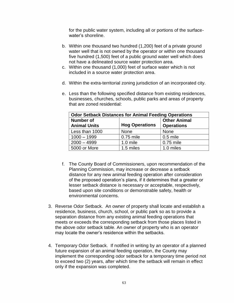
63
for the public water system, including all or portions of the surface-water’s shoreline.
b. Within one thousand two hundred (1,200) feet of a private ground water well that is not owned by the operator or within one thousand five hundred (1,500) feet of a public ground water well which does not have a delineated source water protection area.
c. Within one thousand (1,000) feet of surface water which is not included in a source water protection area.
d. Within the extra-territorial zoning jurisdiction of an incorporated city.
e. Less than the following specified distance from existing residences, businesses, churches, schools, public parks and areas of property that are zoned residential:
Odor Setback Distances for Animal Feeding Operations
Number of Animal Units Hog Operations
Other Animal Operations
Less than 1000 None None
1000 – 1999 0.75 mile 0.5 mile
2000 – 4999 1.0 mile 0.75 mile
5000 or More 1.5 miles 1.0 miles
f. The County Board of Commissioners, upon recommendation of the Planning Commission, may increase or decrease a setback distance for any new animal feeding operation after consideration of the proposed operation’s plans, if it determines that a greater or lesser setback distance is necessary or acceptable, respectively, based upon site conditions or demonstrable safety, health or environmental concerns.
3. Reverse Odor Setback. An owner of property shall locate and establish a
residence, business, church, school, or public park so as to provide a separation distance from any existing animal feeding operations that meets or exceeds the corresponding setback from those places listed in the above odor setback table. An owner of property who is an operator may locate the owner’s residence within the setbacks.
4. Temporary Odor Setback. If notified in writing by an operator of a planned future expansion of an animal feeding operation, the County may implement the corresponding odor setback for a temporary time period not to exceed two (2) years, after which time the setback will remain in effect only if the expansion was completed.
64
5. Sale or Transfer of Ownership. An operator of a facility that includes an animal feeding operation having a permit granted by this ordinance shall notify the County of the sale or the transfer of ownership of the property.
6. Inclusion of Alternative Livestock Type. An operator of a facility that includes an animal feeding operation having a permit granted by this ordinance shall notify the County in writing of intent to include an alternative livestock type at least one hundred-twenty (120) days prior to the anticipated date of the change.
Section 20. Asphalt Plants and Concrete Batch Plants Asphalt plants and concrete batch plants may be permitted in an Agricultural District as a special use, provided:
1. The site is located at least one half (½) mile from any residentially zoned property.
2. A site plan is submitted showing the overall dimensions of the site, the
location of specific activities, fences, parking areas and access roads.
3. A written narrative is submitted describing the operation of the facility, including fugitive dust management, run-off control, and spill containment.
4. A permit to operate is issued by the North Dakota Department of Health
prior to operation of the facility, if required.
5. The County Engineer has approved the proposed access (ingress/egress) for the operation.
6. Any buildings comply with the applicable setback requirements.
Section 21. Wind Turbine Facilities A wind turbine facility may be permitted in an Agricultural District upon approval as a special use, provided the criteria and submittal requirements are met.
I. DEFINITIONS
1. Decibel – A unit of sound measurement, abbreviated dB.
dB(A) - A frequency weighting that relates to the response of the human
ear. The weighted sound pressure level by the use of the A metering
characteristic and weighting specified in American National Standards
Institute (ANSI) Specification of Sound Level Meters.
65
2. Height (of turbine) - The vertical distance from the construction grade of
the property to the highest point of a turbine rotor blade when in the upright position.
3. Non-Participating Dwelling - A dwelling on a non-participating parcel. 4. Non-Participating Parcel - A parcel of real estate that is not a participating
parcel. 5. Occupied Structure - A building in which people live, work or frequent. 6. Participating Dwelling - A dwelling on a participating parcel. 7. Participating Parcel - A parcel of real estate on which any turbine of the
wind turbine facility will be constructed, or for which a participation agreement has been executed.
8. Sound Pressure Level (SPL) - The physical intensity of sound. 9. Wind Turbine Facility - One or more wind turbines, including appurtenant
structures and facilities, rated at an individual or combined nameplate capacity of 150 kilowatts or greater.
II. CRITERIA
1. Appearance. Wind turbines shall be painted with a non-reflective coating and in a uniform, off-white color. Turbines shall not display any advertising except for reasonable identification of the manufacturer or operator of the wind energy facility. The design of the buildings and related structures at the wind energy facility sites shall use materials, textures and location that will blend the wind energy facility to the natural setting and existing environment. Turbines shall be installed on tubular, monopole-type towers.
2. Performance History. All turbines shall be commercially available, utility
scale, with an operational history of at least one year. Prototype turbines are not allowed.
3. Lighting. Wind turbines shall not be artificially lighted, except to the extent
required by the Federal Aviation Administration (FAA) or other applicable governmental regulatory authority.
4. Minimum Ground Clearance. The blade tip of any wind turbine shall, at its
lowest point, have a ground clearance of not less than seventy-five (75) feet.
66
5. Turbine Access Roads and Protection of Agricultural Operations. The
location and construction of access roads and other infrastructure shall, to the extent reasonably possible, not disrupt farming, agricultural operations, or the landscape within Burleigh County. In order to preserve the integrity of fields and capacity for efficient tilling, planting, and harvesting, the applicant shall work with the landowner to determine the most appropriate routing of access road locations.
a. Access roads shall be low profile roads with in-slopes and back-slopes of 10:1 or flatter so that farming equipment can cross them and roadway surfacing shall be Class 5 gravel or similar material, unless otherwise negotiated with the landowner.
b. A plan outlining the location and design of all access roads shall be
provided to the County Planner for determination as to whether the plan conforms to the other terms of this section.
c. If the applicant wishes to build an access road on a section line, in
accordance with North Dakota Century Code (NDCC) Section 24-07-05, the applicant shall first petition the township board or the Board of County Commissioners (in unorganized townships). If the petition is granted, the applicant must build the road to township or county standards under the supervision of the township district roadway overseer.
d. The applicant must protect and segregate topsoil from subsoil on all
lands unless otherwise negotiated with the affected landowner. The applicant must minimize soil compaction of all agricultural lands during all phases and confine soil compaction to as small of an area as possible.
e. The applicant shall, during all phases of construction, abide by the
approved soil erosion control plan in accordance with Section 11 of Article 33 of the Burleigh County Zoning Ordinance.
6. Fence and Gate Repair. The applicant shall promptly repair or replace all fences and gates removed or damaged during all phases of the wind energy facility’s life and provide continuity of electric fence circuits unless otherwise negotiated with the affected landowner.
7. Drainage Tile Repair. The applicant shall take into account, avoid,
promptly repair or replace all drainage tiles broken or damaged during all phases of project life unless otherwise negotiated with the affected landowner.
67
8. Road Repair (Private Roads). The applicant shall promptly repair any damaged private roads, driveways or lanes to a condition at least equal to the condition prior to construction of the wind energy facility, unless otherwise negotiated with the affected landowner.
9. Hazardous Waste. The applicant shall be responsible for compliance with
all federal, state and local laws applicable to the generation, storage, transportation, clean up and disposal of hazardous wastes generated during any phase of the project's life.
10. Chemicals. The use of chemicals is limited to those herbicides and
methods approved by the North Dakota Department of Agriculture and the North Dakota Department of Health. The applicant must contact the affected landowners prior to application.
11. Temporary Staging Areas. The applicant shall negotiate with landowners
to locate sites for temporary equipment staging areas. 12. Tree Removal. The applicant shall minimize the removal of trees and shall
not remove groves of trees or shelter belts without the written approval of the affected landowner. Trimming or removal of trees within the public right-of-way to allow for safe construction of power lines shall be allowed.
13. Waste Removal. The applicant shall remove all waste and scrap that is
the product of construction, operation, restoration and maintenance from the site and properly dispose of it upon completion of each task. Personal litter, bottles, and paper deposited by site personnel shall be removed on a daily basis.
14. Land Restoration. The applicant shall, as soon as practical following
construction of each turbine, considering the weather and preferences of the affected landowner, restore the area affected by any construction activities to the condition that existed immediately before construction began. The time period may be no longer than eight (8) months after completion of construction of the turbine. Restoration shall be compatible with the safe operation, maintenance, and inspection of the wind turbine facility.
15. Complaints. Prior to the start of construction, the applicant shall submit to
the County Planner the company's procedures to be used to receive and respond to complaints.
16. Public Safety Plan. The applicant is encouraged to provide educational
materials to landowners within the site boundaries and, upon request, to interested persons, about the project and any restrictions or dangers associated with the project. The applicant is encouraged to also provide
68
any necessary safety measures, such as warning signs and gates for traffic control or to restrict public access to turbine access roads, substations and wind turbines. The applicant shall comply with provisions outlined in their public safety plan.
17. Fire Protection and Medical Emergency Plans. Prior to construction, the
applicant shall prepare fire protection and medical emergency plans in consultation with the rural fire district, Sheriff’s Department, Emergency Management, and local emergency medical service providers having jurisdiction over the area. The applicant shall submit the project for registry in Burleigh County’s emergency 911 system.
18. Road Use Arrangements. Prior to construction, the applicant shall make
satisfactory arrangements (including obtaining permits) for road use, access road intersections, maintenance and repair of damages with governmental jurisdiction with authority over each road. The applicant shall notify the County Planner of such arrangements upon request.
19. Overweight Load Permits. The applicant is responsible for abiding by the
state and local overweight load permitting processes in accordance with NDCC Chapter 39-12. A special use permit issued under this ordinance to erect a wind turbine facility does not negate a hauler’s obligation to obtain overweight load permits prior to hauling.
20. Approach Permits. The applicant is responsible for obtaining an approach
permit from the County Engineer or the affected township for any new or reconstructed approach.
21. Road Repair (Public Roads). Any road damage caused by the applicant,
its independent contractor, employee, agent, contractor, or subcontractor shall be promptly repaired at the applicant’s expense to current standards set out in the North Dakota Department of Transportation’s (NDDOT) Standard Specifications for Road and Bridge Construction.
If it is reasonably foreseeable that continued trips will make prompt repair
to this standard unreasonable, intermediary measures must be taken by the applicant, if approved by the political subdivision in charge of the road, to ensure the public road remains passable and useable as has been the tradition in the community. Final repairs to these standards must be made promptly after the completion of the construction of the wind turbine facility.
22. Collector Lines. The applicant shall place electrical lines, known as
collectors, and communication cables underground when located on private property, unless otherwise negotiated with the affected landowner. Collectors and cables shall also be placed within or adjacent to the land
69
necessary for turbine access roads unless otherwise negotiated with the affected landowner.
23. Feeder Lines. The applicant shall place overhead or underground electric
lines, known as feeder lines, on private land immediately adjacent to public rights-of-way (whether improved or not) except as necessary to avoid or minimize human, agricultural, or environmental impacts.
a. Feeder lines may be placed on public rights-of-way only if approval
or the required permits have been obtained from the governmental unit responsible for the affected right-of-way.
b. In all cases, the applicant shall avoid placement of feeder lines in
locations that may interfere with agricultural operations.
c. Any guy wires on the structures for feeder lines shall be marked with safety shields.
d. When feeder lines are placed on private property, the applicant
shall place the feeder lines in accordance with the easement negotiated with the affected landowner(s).
e. All underground feeder lines must be placed at a depth of at least
four (4) feet.
24. Electromagnetic Interference Assessment. The applicant shall submit an assessment of microwave signal patterns in the project area prior to commencement of construction of the project.
a. The assessment shall be designed to provide data that can be used in the future to determine whether the turbines and associated facilities are the cause of disruption or interference of microwave patterns in the event residents complain about such disruption or interference after the turbines are placed in operation. The assessment shall be completed prior to operation of the turbines.
b. The applicant shall be responsible for alleviating any disruption or
interference caused by the turbines or any associated facilities of residents’ cell phone, television, radio, computer, satellite or other electronic transmissions, receptions, or services.
c. The applicant shall not operate the wind turbine facility so as to cause microwave, television, radio, telecommunications or navigation interference contrary to Federal Communications Commission (FCC) regulations or federal, state or local laws.
70
d. In the event the wind turbine facility or its operations cause such interference as described in items b and c above, the applicant shall take measures necessary to correct the problem within thirty (30) calendar days.
25. Archeological Resource Survey and Consultation. Unless the project is under the purview of the North Dakota Public Service Commission (PSC), and an Archeological Resource Survey is being prepared as part of that process, the applicant shall work with the State Historic Preservation Office (SHPO) at the State Historical Society of North Dakota at the beginning of the planning process for the wind energy facility to determine whether an archaeological survey is recommended for any part of the proposed project. If recommended, the applicant shall contract with a qualified archaeologist to complete such surveys, and shall submit the results to the County Planner and the SHPO. The SHPO will make recommendations for the treatment of any significant archaeological sites which are identified. Any issues in the implementation of these recommendations will be resolved by Board of County Commissioners in consultation with the SHPO. All information provided/submitted under this provision is subject to North Dakota Century Code Section 55-02-07.1.
In addition, if any archaeological sites or human remains are found during
construction, the applicant shall follow standard operating procedures as
established by the SHPO and in accordance with NDCC Section 23-06-27
and associated North Dakota Administrative Code 40-02-03.
26. Biological Resources Survey. The applicant, in consultation with the US Fish & Wildlife Service - Ecological Services Office (USFW) and the North Dakota Department of Game and Fish (NDGF) shall, for the project site, conduct a pre-construction inventory of existing wildlife management areas, scientific and natural areas, recreation areas, native prairies and forests, wetlands, and any other biologically sensitive areas and wildlife resources, particularly birds and bats, within the site and assess the presence of state- or federally-listed or threatened species, and other protected species, such as migratory birds. The results of the survey shall be submitted to the County Planner, USFWS and NDGF.
27. Extraordinary Events. Within twenty-four (24) hours of an occurrence, the applicant shall notify the County Auditor\Treasurer of any extraordinary event. Extraordinary events include, but shall not be limited to, fires, tower collapse, thrown blade, collector or feeder line failure, or injured wind turbine facility worker or private person. The applicant shall, within thirty (30) calendar days of the occurrence, submit a report to the County Auditor\Treasurer describing the cause of the occurrence and the steps taken to avoid future occurrences.
71
28. Wildlife Incidents. Any fatality or injury to any state- or federally-listed species or migratory bird or bat shall immediately be reported to the U.S. Fish and Wildlife Service (USFWS)-North Dakota Field Office and the USFWS Office of Law Enforcement. Also, if a dead or injured whooping crane or sandhill crane is found, operation of all turbines shall be immediately curtailed until it has been determined by the USFWS that there is no longer a threat to other birds in the area. If a whooping crane or sandhill crane is sighted by a wildlife biologist within two (2) miles of any wind turbine, that turbine or turbines should be immediately shut down, and the USFWS should be contacted for further coordination. Cranes usually move on within a few days, at which time, in consultation with the USFWS, the turbine(s) may be restarted.
29. Sound. A sound study which includes modeling of sound levels of wind turbines within 100-feet of every occupied residence within 1-mile of a wind turbine shall be submitted with the application. Sound levels of wind turbines within 100-feet of any non-participating residence shall not exceed 45dBA (leq). Construction noise or reasonable and necessary maintenance activities are allowed to exceed this sound limit except between the hours of 11 p.m. and 7 a.m. This sound standard does not apply to participating dwellings.
30. Setbacks from Dwellings. Minimum setbacks from dwellings are
necessary to mitigate noise impacts. Wind turbines shall be setback at least 1.1 times the height of the turbine
from participating residences, and at least 1750 feet from existing non-
participating residences (measured from the center of the turbine
monopole), and further as necessary to meet the sound level requirement
in Subsection 29 above.
The horizontal distance between the center of a turbine monopole and any
park, boat ramp, swimming beach or other public recreation area shall not
be less than one-half (½) mile (2,640 feet).
31. Reverse Setbacks. Building permits will not be issued to construct any
proposed habitable structure within 1.1 times the height of any existing turbine (the center of a turbine monopole) or approved turbine location.
32. Setbacks from Non-Participating Properties. Each wind turbine shall be set back not less than 1.1 times the height of the turbine from any non-participating parcel.
72
33. Setbacks from Public Roadways. Each wind turbine shall be set back not less than 1.1 times the height of the turbine from interstate or state roadway right-of-way.
Each wind turbine shall be set back not less than 1.1 times the height of
the turbine plus seventy-five (75) feet from the centerline of any county or township roadway (whether improved or not).
Each wind turbine shall be set back not less than 1.1 times the height of
the turbine from any railroad right-of-way or from any overhead utility. 34. Setback from Missouri River and Lake Oahe: Each wind turbine shall be
set back not less than one (1) mile beyond the ordinary high water mark.
35. Shadow Flicker. A shadow flicker analysis, assuming typical meteorological conditions, shall be submitted for all occupied residences of non-participants within one-mile of a wind turbine. The maximum acceptable level of shadow-flicker exposure for homes in the study shall be 30 hours per year. The applicant shall provide commercially reasonable efforts to remedy shadow-flicker complaints from any non-participating owners of an occupied residence with a window view of a wind turbine on a case-by-case basis by undertaking measures such as trees or vegetation plantings, awning installations, or providing light-blocking curtains or shades.
36. Pre-construction Meeting. Prior to the start of any construction, the
applicant shall conduct a preconstruction meeting with the County Building Official to coordinate field monitoring of construction activities. The pre-construction meeting shall be open to all interested parties and shall address staging, complaints, emergency plans, and other pertinent issues.
37. As-Built Plans and Specifications. Within one hundred eighty (180)
calendar days after completion of construction, the applicant shall submit to the County Building Official, a copy of the as-built plans and specifications in both hard copy and in electronic digital format as specified by the County Planner.
38. Decommissioning Plan and Bonding Requirement. The wind project shall
develop a Wind Turbine Decommissioning Plan in accordance with NDCC 49-02-27 and NDAC 69-09-09 and this Plan and Bond shall be submitted as part of the Building Permit application.
39. Insurance Requirement. The owner/operator of a wind turbine facility must
provide proof of liability insurance at the time of application. Burleigh County shall be listed as a certificate holder. Certificates shall provide not
73
less than thirty (30) calendar days’ notification to the certificate holder prior to cancellation or material change in coverage. Throughout the duration of this special use permit, the owner/operator of a wind turbine facility agrees to provide evidence of insurance coverages not less than the types and amounts specified below:
a. Workers’ Compensation: Statutory
b. Employer’s Liability Each Accident: $1,000,000 Disease, Policy Limit: $1,000,000 Disease, Each Employee: $1,000,000
c. General Liability
General Aggregate: $2,000,000 Each Occurrence
(Bodily Injury and Property Damage): $1,000,000
d. Excess Umbrella Liability
Each Occurrence: $5,000,000 General Aggregate: $5,000,000
e. Automobile Liability
1) Combined Single Limit (Bodily Injury and Property Damage): Each Accident $1,000,000
f. Other Conditions (specify):
1) A Commercial General Liability policy shall be endorsed to
add Burleigh County, its employees, officers, agents and contractors as additional insured.
2) Certificates evidencing required insurance shall be provided
to Burleigh County upon approval of the special use permit and prior to commencement of construction.
40. Contact Information. The applicant must provide a local contact authorized
by the applicant to receive service and respond to all notices, demands, complaints, concerns or other requests. Local contact information must include the name of the local representation, local phone number and physical address. Said contact information must be filed with the County Auditor\Treasurer prior to commencement of construction of the wind energy facility.
74
41. Transfer of Ownership of a Wind Turbine Facility. Prior to any change in ownership or assignment of a controlling interest of any entity owning a wind energy facility permitted in Burleigh County, including any assignment or transfer of a controlling interest to any corporation, partnership, or other entity controlled by or a subsidiary or affiliate of the wind energy facility permitted in Burleigh County, application shall be made to Burleigh County Planning Commission, requesting transfer of the wind energy facility special use permit. Approval of such transfer shall be conditioned upon explicit agreement by the new applicant to comply with the requirements and conditions of this ordinance, as amended, and the special use permit. The application shall also include the new applicant’s agent and contact information. A change of ownership that results in inability, unwillingness, or failure to abide by the conditions of this ordinance can be a basis for revocation of the special use permit. [This limitation shall apply to all transfers by operation of law and any transfers by trustee in bankruptcy, receivers, administrators, executors, and legatees.]
42. Changes. Any minor changes in the location or character of wind turbine
facilities and structures may be authorized in writing by the County Planner. All other changes shall require approval of an amended special use permit under these same ordinance requirements.
III. SPECIAL USE PERMIT APPLICATION SUBMITTAL ITEMS
The following items shall accompany the special use permit application:
1. Two (2) copies of a site plan submitted on high quality paper on sheets thirty (30) inches by thirty-six (36) inches, provided that when more than one sheet is required, there shall also be submitted an index sheet on high quality paper and of the same dimensions, showing the entire wind turbine facility project on one sheet and giving section, township and range numbers. The applicant must also submit this data in electronic digital format as specified.
2. The site plan shall be drawn to a scale of one (1) inch equals one
thousand (1,000) feet or less with scale to be shown graphically. 3. To provide adequate coverage, the site plan shall show an area up to a
minimum of three-quarters (¾) mile (3,960 feet) beyond the outermost wind turbine towers, meteorological towers, all wind turbine facility access roads and appurtenant project structures.
4. Site plans shall contain the following elements:
a. Name of the wind turbine facility b. Name and address of the wind turbine facility owner
75
c. Name, address, and registration number of professional surveyor involved in preparing the site plan
d. Date the site plan was prepared e. North point indication f. Section, township and range numbers g. Topographic contours with a minimum contour interval of ten (10)
feet, with indication of datum used h. A location map inset showing the township(s) in which the project is
located and the boundary of the proposed project i. Location of all existing public roadways and rights-of-way within five
hundred (500) feet of proposed turbine locations j. General location and railroad rights-of-way, as available from public
documents, within five hundred (500) feet of proposed turbine locations
k. Name, dimensions and location of any utility easements, as available from public documents, within five hundred (500) feet of proposed turbine locations
l. Name, dimensions and location of any parks, public land, historic resources, multi-use trails, or areas of recreational significance, as available from public documents, within three thousand (3000) feet of proposed turbine locations
m. Name, dimensions and location of habitable structures n. Location of any corporate or township boundaries o. General location and identification of section lines, as available
from public documents p. General property ownership boundary lines, as available from
public documents, for properties within five hundred (500) feet of proposed turbine locations
q. Names of property owners, identified as participating or non-participating, within five hundred (500) feet of proposed turbine locations
r. Streams, rivers, watercourses, lakes, and any marshy or swampy areas
s. Federally designated wetland areas t. All affected public or private airstrips with the FAA identification
number u. Proposed turbines locations v. Names of property owners, as available from public documents,
within five hundred (500) feet of proposed turbine locations w. Participating residences within five hundred (500) feet of proposed
turbine locations, non-participating residences within two thousand (2000) feet of proposed turbine locations, and parks, boat ramps, swimming beaches or other public recreation areas within three thousand (3000) feet of proposed turbine locations, as available from public documents
76
5. Other Submittal Items
a. Statement of assurance that the project will not alter any existing surface water drainage patterns.
b. Plan for Restoration of the Site Due to Construction c. Plan for Receiving and Responding to Complaints d. Public Safety Plan e. Fire Protection and Medical Emergency Plan f. Biological Preservation Study g. Shadow Flicker Study h. Decommissioning Plan and Bond The facility or turbine owner or
operator shall file with the Special use application the estimated decommissioning cost per turbine, in current dollars at the time of filing, for the proposed facility or turbine and a comprehensive decommissioning plan that describes any expected effects on present and future natural resource development and how the facility or turbine owner or operator plans to pay for decommissioning of the facility or turbine as required. The commission may at any time require the owner operator of a commercial wind energy conversion facility or wind turbine to file a report with the Planning and Zoning Commission describing how the facility or turbine owner or operator is fulfilling this obligation, The owner or operator shall secure a performance bond, surety bond, letter of credit, corporate guarantee, or other form of financial assurance that is acceptable to the Planning and Zoning Commission to cover the anticipated costs of decommissioning the commercial wind energy conversion facility or turbine.
i. Copies of letters of application from the applicant to the following agencies requesting review of the proposed wind turbine facility:
1. United States Fish and Wildlife Service (USFW) 2. North Dakota Game and Fish Department (NDGF) 3. The State Historic Preservation Office (SHPO) at the State
Historical Society of North Dakota 4. Federal Aviation Administration (FAA)
6. Fees. The special use permit fee is .001 (1/10th of 1%) of the value of
each wind turbine in accordance with Article 25 of the Burleigh County Zoning Ordinance. An application fee of $1000 shall be payable at the time of application for a special use permit, with the remainder of the special use permit fee remitted by the applicant prior to building permit application(s).
77
IV. BUILDING PERMIT APPLICATION SUBMITTAL ITEMS
1. An application for a building permit for the construction of a wind turbine facility must include:
a. A copy of the special use permit, with the site plan, as approved by
the Burleigh County Board of Commissioners and, if applicable, a copy of the permit as approved by the North Dakota Public Service Commission (PSC).
b. Additional site plan items not included with special use permit site plan submittal, including:
1. Name, location and width of all existing public roadways and rights-of-way within five hundred (500) feet of proposed turbine locations, including the type and width of surfacing
2. Existing and proposed access points along public rights-of-way
3. All existing wind turbine facility fixtures, regardless of ownership, accessory structures or buildings, including substations, meteorological towers, electrical infrastructure, and collector or transmission lines
4. Proposed turbine locations showing turbine heights, roads, electrical equipment, collector and feeder lines and all other associated facilities
5. Location and dimensions of proposed utility easements, including easements for storm water management facilities and proposed locations of culverts and retention/detention areas, if applicable
6. Boundaries of any filed lease, easement, or option for wind energy facilities, whether they benefit the applicant, the applicant’s probable operator, or an unrelated party
c. Dimensioned engineering drawings of all wind turbine facility structures, including electrical schematic line drawings of the electrical components in sufficient detail to allow for a determination that the manner of installation will meet compliance with the electrical code.
d. Documentation certifying structural loading requirements. e. The applicant shall identify, by map, each public road in Burleigh
County that the applicant may or will travel on with a gross weight in excess of 80,000 lbs.
f. Reclamation Performance Bonding g. Electromagnetic Interference Assessment h. Proof of Insurance
78
i. Soil Erosion Control Plan in accordance with Section 10 of Article 33 of the Burleigh County Zoning Ordinance
j. National Pollution Discharge Elimination System (NPDES) construction permit
k. A building permit fee of $500 per wind turbine. l. Copies of letters of acceptance regarding the proposed wind
turbine facility from the following agencies:
1. United States Fish and Wildlife Service (USFW) 2. North Dakota Game and Fish Department (NDGF) 3. The State Historic Preservation Office (SHPO) at the State
Historical Society of North Dakota 4. Federal Aviation Administration (FAA)
Section 22. Roadway Maintenance Facilities
Roadway maintenance facilities necessary for the provision of services by a governmental entity may be permitted in an Agricultural District as a special use, provided:
1. The parcel meets the minimum lot area and width requirements for the
Agricultural District.
2. The parcel is located along an improved section line roadway or other roadway classified as an arterial.
3. The parcel is located at least one half (½) mile (2640 feet) from any residentially zoned property.
4. Any buildings comply with the applicable setback requirements.
5. All exterior equipment and material storage areas will be set back no less than one hundred fifty (150) feet from a front property line and no less than seventy-five (75) feet from a side or rear property line.
6. A landscaped buffer yard is provided around the perimeter of the site to screen the operation from adjacent land uses. Said buffer yard shall be no less than fifty (50) feet in width and shall be densely planted in conjunction with site development.
7. A site plan is submitted showing the overall dimensions of the site, the location of specific activities, fences, parking areas, adjacent roadways and proposed access (ingress/egress).
8. A written narrative is submitted describing the operation of the facility, including fugitive dust management, run-off control, and spill containment.
79
Section 23. Temporary Worker Housing
Temporary worker housing may be permitted in the A Agricultural District as a special use, provided:
1. The parcel on which the housing facility is located meets the lot area and
width requirements for the A Agricultural District.
2. The housing facility is located along, or with direct access to, an improved section line roadway or other roadway classified as an arterial. If the arterial roadway is not improved, the developer/operator would be responsible for construction and paving of said roadway to County standards, if required based on site location, prior to operation of the housing facility.
3. The housing facility is located where traffic to and from the facility would not have to travel on roadways within or adjacent to residentially zoned property.
4. The temporary housing facility provides accommodations for at least
twenty (20) workers and no more than five hundred (500) workers.
5. The parcel on which the facility is located is at least one-half (1/2) mile from any residentially zoned property.
6. The parcel on which the facility is located is at least one (1) mile from the ordinary high water mark of the Missouri River and Lake Oahe.
7. All buildings and modular structures shall comply with the applicable setback requirements for the A Agricultural District.
8. The facility shall be constructed to minimize erosion, alteration of natural features and removal of vegetation to the greatest extent possible.
9. Any modular structures for the facility must be inspected by an IBC
(Industrialized Building Commission) approved third party inspector prior to entering the state, have an IBC label affixed, and must also be constructed in compliance with the North Dakota State Building Code, as amended by Burleigh County (Article 23).
10. All structures used for temporary worker housing shall be placed on a
permanent foundation except as allowed in accordance with Chapter 18 of the International Building Code.
11. All structures used for temporary worker housing shall meet the County’s
minimum housing standards (Article 34).
80
12. The temporary housing facility must be fenced and access limited.
13. The temporary housing units must be numbered in a logical fashion in
order to facilitate emergency response and in accordance with Chapter 5 of the International Building Code.
14. The distance between structures shall be in accordance with the North
Dakota State Building Code, as amended by Burleigh County (Article 23). 15. The temporary housing facility must comply with all applicable State and
Federal requirements, including the requirements of the North Dakota Department of Health, the North Dakota State Electrical Board, the North Dakota State Plumbing Board, the North Dakota State Water Commission, the North Dakota Department of Transportation and the North Dakota Department of Commerce.
16. The temporary housing facility shall provide parking at a rate of 2.5 spaces
per resident, based on design capacity, to accommodate personal vehicles, work vehicles, and other vehicles and equipment parked on the site. Parking shall be located away from the housing units and shall not be allowed between units.
17. The temporary housing facility shall provide for adequate fire suppression,
adequate access for emergency vehicles, and adequate security for the facility.
18. Domestic animals other than those owned by the property owner or the
on-site manager are not allowed on the premises of a temporary housing facility.
19. The operator of the temporary housing facility is responsible for
establishing and enforcing any house rules or regulations for residents. 20. The following information is submitted in addition to the information
required under Section 1 of this Article:
a. A written narrative that includes a general description of the operation, including a good faith estimate of the duration of use; a description of the temporary housing units to be used and how the housing units are to be set and/or anchored to the ground in accordance with any applicable ANSI standards; a description of how the units are to be numbered; and a description of the source of potable water supply, method of sewage disposal, method of waste disposal and method of dust control.
81
b. A scaled site plan showing the overall dimensions of the site; required setbacks; the location of housing units, other structures, parking areas, fences, and landscaping; the location of existing and proposed roads and access ways within and adjacent to the site; topographic contours with a minimum interval of five (5) feet; the location of surface water, streams, and/or drainage areas and special flood hazard areas on or within 500 feet of the site; and the location of wells, sewage treatment system(s), and waste management areas.
c. A storm water management plan in accordance with Section 13 of
the Subdivision Regulations (Article 33). A construction activity permit from the North Dakota Department of Health is also required for construction disturbance of one (1) or more acres.
d. A traffic impact analysis to determine if any improvement to County
or State roadways, including the paving of roadways or the installation of turning lanes, is warranted. If warranted, roadway improvements will need to be installed at the operator’s expense prior to operation of the facility.
e. Copies of the facility’s proposed house rules and regulations, on-
site security plan, and on-site emergency management plan (including contingencies for fire, tornado and other natural disasters).
f. A statement as to whether or not the applicant has ever engaged in
the business of owning or operating a temporary worker housing facility before, and if so, the dates and locations of such ownership or operation.
g. A copy of the lease or purchase agreement, if the property is not
owned by the proposed operator. Financial terms of the lease or purchase agreement may be redacted.
h. Any other information required by the County to make an informed
decision on the request.
21. The County Board of Commissioners may attach any conditions or reporting requirements to the special use permit that it deems necessary and prudent.
22. If the request for a special use permit is approved, all required County
permits shall be obtained prior to construction of the temporary housing facility, including, but not limited to, building permits, plumbing permits and mechanical permits.
82
23. If the request for a special use permit is approved, the following shall be
provided to the County in conjunction with construction and prior to operation of the temporary housing facility:
a. The name and address of the onsite manager and contact
information. b. Copies of required permits or approvals from the North Dakota
Department of Health, the North Dakota State Electrical Board, the North Dakota State Plumbing Board, the North Dakota State Water Commission, South Central Regional Water District, North Dakota Department of Transportation, and US Army Corps of Engineers.
c. A plan for the closing of the facility and reclamation of the site,
including how structures and equipment will be removed; how trash and construction debris will be removed; how concrete footings and foundations will be removed or buried; how the sewage disposal system will be removed and disposed of; how the site will be graded and re-contoured to blend into the surrounding topography; how topsoil will be replaced and the site seeded with an appropriate seed mix to establish sufficient cover to stabilize the site and prevent erosion, and how unneeded access roads will be regarded and re-vegetated.
d. An irrevocable surety bond shall be submitted to the County Auditor
in an amount equal to an engineer’s estimate of the cost of removing or demolishing such facilities following termination of the use in accordance with the approved plan, and shall be held for the duration of the temporary worker housing operation. The amount of the bond may be reviewed by the County Board of Commissioners on an annual basis and adjusted if needed.
24. If the request for a special use permit is approved, the following shall be
provided to the County on an ongoing basis for the duration of operations: a. The name and address of the onsite manager and contact
information.
b. A current occupancy list to be maintained and provided to the County on a monthly basis.
c. Any changes to the facility’s house rules and regulations, on-site
security plan, and on-site emergency management plan.
25. The operator of a temporary worker housing facility permitted by Burleigh
83
County shall notify the County Auditor of the sale of the facility or the transfer of ownership of the property.
26. A special use permit for a temporary housing facility approved in
accordance with this Article shall be valid for a period of five (5) years, and is renewable in three (3) year increments upon submittal of a request for an extension and approval in accordance with the provisions of this Article. The request for an extension must also include a written narrative describing the facility, its compliance with the requirements contained herein and any conditions placed upon it, and demonstrate the continued need for the facility.
27. The temporary housing facility and any associated structures must be removed from the site within ninety (90) days of closure. Within ninety (90) days after the removal of the facility is complete, a reclamation report shall be submitted to the County Planner indicating that the site was reclaimed as set forth in the approved reclamation plan.
Section 24. Meat Packing Facilities
Meat packing facilities may be permitted in the I Industrial District as a special use, provided:
1. The parcel on which the facility is located meets the minimum lot area and
width requirements for the I Industrial zoning district. 2. The facility is located along, or with direct access to, an improved section
line roadway or other roadway classified as an arterial. If the arterial roadway is not improved, the developer/operator would be responsible for construction and paving of said roadway to County standards prior to operation of the facility.
3. The facility is located where traffic to and from the facility would not have to travel on roadways within or adjacent to residentially zoned property.
4. The parcel on which the facility is located is at least one (1) mile from any
residentially zoned property. 5. The facility is located or so designed so that the odor and heat from the
facility will not have a negative impact on adjacent properties. 6. A landscaped buffer yard is provided around the perimeter of the site to
screen the operation from adjacent land uses. Said buffer yard shall be no less than fifty (50) feet in width and shall be densely planted in conjunction with site development.
84
7. All buildings shall comply with the applicable setback requirements for the I Industrial zoning district, as measured from the inside edge of the required landscape buffer yards.
8. A site plan is submitted showing the overall dimensions of the site;
existing and proposed roads and access ways within and adjacent to the site; topographic contours with a minimum interval of five (5) feet; surface water, streams, drainage areas and special flood hazard areas on or within 500 feet of the site; and locations of existing and proposed buildings, fences, loading/unloading areas, outdoor storage areas, wells, sewage treatment system(s), waste management areas, confinement areas (indoor and/or outdoor) and parking areas.
9. A written narrative is submitted describing the operation of the facility,
including the number and type of animals processed, the length of any on-site confinement, source of water supply, method of sewage disposal, method of waste disposal, pest management, storm water management, and odor management.
10. A traffic impact analysis is submitted to determine if any improvement to
County or State roadways, including the paving of roadways or the installation of turning lanes, is warranted. If warranted, roadway improvements will need to be installed at the operator’s expense prior to operation of the facility.
11. The facility as proposed will comply with all applicable State and Federal
requirements, including the requirements of the North Dakota Department of Agriculture Meat and Poultry Inspection Program, the North Dakota Department of Health and the United States Department of Agriculture.
12. Any animal confinement operations in conjunction with the meat packing
facility are subject to the County’s requirements for animal feeding operations.
13. Prior to construction or establishment of a meat packing facility, the
operator may be required to file an irrevocable surety bond with the County Auditor. Such bond shall be in an amount equal to an engineer’s estimate of the cost of removing or demolishing such facilities and shall be held for the duration of the meat packing facility operation. The amount of the bond may be reviewed by the County Board of Commissioners on an annual basis and adjusted if needed.
Section 25. Limited Meat Packing Facilities
Limited meat packing facilities may be permitted in the A Agricultural District as a special use, provided:
85
1. The parcel on which the facility is located meets the minimum lot area and
width requirements for the A Agricultural zoning district. 2. The facility is located along, or with direct access to, an improved section
line roadway or other roadway classified as an arterial. If the arterial roadway is not improved, the developer/operator would be responsible for construction and paving of said roadway to County standards prior to operation of the facility.
3. The parcel on which the facility is located is at least one-quarter (1/4) mile
from any residentially zoned property. 4. The facility is located or so designed so that the odor from the facility will
have limited negative impact on adjacent properties.
5. All buildings shall comply with the applicable setback requirements for A Agricultural zoning district.
6. A site plan is submitted showing the overall dimensions of the site;
existing and proposed roads and access ways within and adjacent to the site; topographic contours with a minimum interval of five (5) feet; surface water, streams, drainage areas and special flood hazard areas on or within 500 feet of the site; and locations of existing and proposed buildings, fences, loading/unloading areas, outdoor storage areas, wells, sewage treatment system(s), waste management areas, confinement areas (indoor and/or outdoor) and parking areas.
7. A written narrative is submitted describing the operation of the facility, including the number and type of animals processed, the length of any on-site confinement, source of water supply, method of sewage disposal, method of waste disposal, pest management, storm water management, and odor management.
8. A traffic impact analysis is submitted to determine if any improvement to County or State roadways, including the paving of roadways or the installation of turning lanes, is warranted. If warranted, roadway improvements will need to be installed at the operator’s expense prior to operation of the facility.
9. The facility as proposed will comply with all applicable State and Federal requirements, including the requirements of the North Dakota Department of Agriculture Meat and Poultry Inspection Program, the North Dakota Department of Health and the United States Department of Agriculture.
10. Any animal confinement operations in conjunction with the meat packing
86
facility are subject to the County’s requirements for animal feeding operations.
11. Prior to construction or establishment of a meat packing facility, the operator may be required to file an irrevocable surety bond with the County Auditor. Such bond shall be in an amount equal to an engineer’s estimate of the cost of removing or demolishing such facilities and shall be held for the duration of the meat packing facility operation. The amount of the bond may be reviewed by the County Board of Commissioners on an annual basis and adjusted if needed.
Section 26. Medical Marijuana Manufacturing or Distribution Center
All persons, entities or organizations wishing to establish a Medical Marijuana Manufacturing Center(s) or Distribution Center(s) within Burleigh County must apply for and be granted a special use permit for said use.
1. The use, cultivation, manufacturing, production, distribution, possession and transportation of marijuana remains illegal under federal law, and marijuana remains classified as a "controlled substance" by both North Dakota and Federal law;
2. The Board of County Commissioners does not have the authority to, and
nothing in this chapter is intended to, authorize, promote, condone or aid the production, distribution or possession of medical marijuana in violation of any applicable law;
3. The Board of County Commissioners intends to regulate the use,
acquisition, cultivation, manufacturing, and distribution of usable medical marijuana in a manner that is consistent with the North Dakota Century Code. The regulations are intended to apply to all medical marijuana operations in Burleigh County by any medical marijuana business permitted under state law. Medical marijuana cultivation and production can have an impact on health, safety, and community resources, and this chapter is intended to permit state-licensed Medical Marijuana Manufacturing Center(s) or Distribution Center(s) where they will have a minimal negative impact;
4. To the extent that Medical Marijuana Manufacturing Center(s) or
Distribution Center(s)s are registered and authorized by the State of North Dakota to operate in Burleigh County, this Commission desires to provide for their regulation to protect the public health, safety and general welfare of the citizens of Burleigh County.
5. This chapter is to be construed to protect the public over medical
marijuana business interests. Operation of a medical marijuana business
87
is a revocable privilege and not a right in Burleigh County. There is no property right for an individual or business to have medical marijuana in Burleigh County.
6. The purpose of this chapter is to protect the public health, safety, and welfare of the residents and patients of Burleigh County by prescribing the manner in which medical marijuana businesses can be conducted in Burleigh County. Further, the purpose of this chapter is to:
a. Provide for a means of cultivating, manufacturing and distribution of
usable Medical Marijuana to patients who qualify to obtain, possess, and use marijuana for medical purposes as prescribed by state law.
b. Create regulations that address the particular needs of the facilities, patients and residents of Burleigh County and comply with laws that may be enacted by the state regarding medical marijuana.
2. Definitions Unless specified in this ordinance in section 26, all terms defined in N.D.C.C. § 19-24.1-01 or successors to that statute shall have the definitions provided therein. 3. Special Use Permit Requirements In addition to the requirements applicable to all Special Use Permit applications, an application for a Special use permit for a Medical Marijuana Manufacturing Center(s) or Distribution Center(s) which shall be located in an A-Agricultural, I-Industrial, C-Commercial or PUD-Planned Unit Development Zoned District and must include the following:
1. A complete description of the products and services to be produced or sold by the Medical Marijuana Manufacturing Center(s) or Distribution Center(s).
2. A notarized statement acknowledging that the applicant understands
applicable federal laws, any guidance or directives issued by the U.S. Department of Justice, the laws of the State of North Dakota and the laws and regulations of Burleigh County applicable thereto concerning the operation of a Medical Marijuana Manufacturing Center(s) or Distribution Center(s). The written statement shall also acknowledge that any violation of any laws or regulations of the State of North Dakota or of Burleigh County, or any activity in violation of any guidance or directives issued by the U.S. Department of Justice, in such place of business, or in connection therewith, or the commencement of any legal proceeding relating to such
88
Medical Marijuana Manufacturing Center(s) or Distribution Center(s) by federal authorities, may render the Special Use Permit subject to immediate suspension or revocation.
3. A notarized statement that the applicant will hold harmless, indemnify, and
defend Burleigh County against all claims and litigation arising from the issuance of a special use permit including any claims and litigation arising from the Manufacturing Center(s) or Distribution Center(s), operation or ownership of the Medical Marijuana Manufacturing Center(s) or Distribution Center(s).
4. A notarized acknowledgement that the applicant is seeking a Medical
Marijuana Manufacturing Center(s) or Distribution Center(s) Special use permit and that the applicant understands and acknowledges that the burden of proving qualifications to receive such a Special use permit is at all times on the applicant; that the granting of a Special use permit for a Medical Marijuana Manufacturing Center(s) or Distribution Center(s) is at the discretion of the Board of County Commissioners; and that the applicant agrees to abide by the decision of the Board of County Commissioners.
5. The Building Official/Director may require additional plans, documents or
other information prior to deeming the application complete subject to the approval of the Board of County Commissioners.
6. If the State of North Dakota or its electorate repeals the Compassionate
Care Act or the act is otherwise declared void, all Medical Marijuana Manufacturing Center(s) or Distribution Center(s) Special Use Permits issued by the Board of County Commissioners will be deemed to have immediately expired.
7. Once a special use permit is obtained for a Medical Marijuana
Manufacturing Center(s) or Distribution Center(s), any change in operation of the facility or in ownership shall require prior approval of the Board of County Commissioners.
8. Any building modifications or alterations must be approved by the Burleigh
County Building Official. 4. Design Standards: All applicable state standards and requirements shall apply in the design and operations of any Manufacturing Center(s) or Distribution Center(s).
1. Each Medical Marijuana Manufacturing Center(s) or Distribution Center(s) must be located in a separate, permanent, stand-alone structure and have
89
a minimum six (6) foot high perimeter fence encompassing the parcel boundary.
2. Each Medical Marijuana Manufacturing Center(s) or Distribution Center(s)
must be located a minimum of 2,640 feet from a public or private preschool, kindergarten, elementary, secondary or high school, public park, public community center, dependent care facility, homeless shelter, youth center, or place of worship. The distance shall be measured from the exterior fence of the Medical Marijuana Manufacturing Center(s) or Distribution Center(s) to the property line of the protected use.
3. Each Medical Marijuana Manufacturing Center(s) or Distribution Center(s)
must be located a minimum of 500 feet from any residential district, or any residential dwelling, trailer, recreational vehicle or recreational district. The distance shall be measured from the exterior fence of the Medical Marijuana Manufacturing Center(s) or Distribution Center(s) to the property line or dwelling of the protected use.
4. No Medical Marijuana Dispensary shall have operating hours earlier than
8:00 AM or later than 7:00 PM.
5. The entire perimeter of a Medical Marijuana Manufacturing Center(s) or Distribution Center(s) structure must be well lit (minimum 1 candle foot) to prevent concealment in shadows around the structure for a minimum of 15 feet around each structure that is part of the Medical Marijuana Manufacturing Center(s) or Distribution Center(s). Further, everything within the fenced area shall have 24hour surveillance cameras depicting the entire exterior of the Manufacturing Center(s) or Distribution Center(s) as well as cameras at the property entrance depicting vehicles and license plates of each vehicle entering the parking lot.
6. Each Medical Marijuana Distribution Center shall have at least 1 parking
space per 250 sq. ft. of structure.
7. Each Medical Marijuana Cultivation and/or Manufacturing Facility shall have at least 1 parking space for every 1000 sq. ft. of plant cultivation area and 1 parking space for each 250 sq. ft. of all other areas of the structure.
8. With the exception of the specific Medical Marijuana Manufacturing
Center(s) or Distribution Center(s) approved as part of a Special Use Permit, no other activity may occur within the facility or land parcel.
9. No outdoor storage on-site shall be permitted.
10. No drive-through, drive-up, or walk-up facilities shall be permitted.
90
5. Serviceability, Exclusions and Exceptions:
1. The provisions of this chapter do not waive or modify any other provision of this ordinance with which Medical Marijuana Manufacturing Center(s) or Distribution Center(s) is required to comply. Nothing in this section is intended to authorize, legalize or permit the Manufacturing Center(s) or Distribution Center(s), operation or maintenance of any facility, building or use which violates any Burleigh County ordinance or statute of the State of North Dakota regarding public nuisances, Medical Marijuana, or any federal regulations or statutes relating to the use of controlled substances.
2. This chapter shall be null and void if any determination is made, after the
adoption of the ordinance enacting this chapter, by any court of competent jurisdiction, that Ch. 19-24. N.D.C.C., is invalid, or shall be null and void to the extent any portion of such section is held invalid.
3. Should any section, subsection, clause or provision of this chapter for any reason be held to be invalid or factually unconstitutional, such invalidity or unconstitutionality shall not affect the validity or constitutionality of the remaining portions of this chapter, it being hereby expressly declared that this chapter, and each and every section, subsection, sentence, clause and phrase hereof would have been prepared, proposed, approved, adopted and/or ratified irrespective of the fact that any one or more section, subsections, sentences, clauses or phrases of this chapter be declared invalid or unconstitutional.
91
ARTICLE 9
NON-CONFORMING USES
Section 1. Definition Any lawful use of the land or buildings existing at the date of passage of this resolution, and located in a district in which it would not be permitted as a new use under the provisions of this regulation, is hereby declared to be a non-conforming use, and not in violation of this regulation at the date of adoption of such regulation. Provided, however, a non-conforming use shall be subject to, and the owner shall comply with the following regulations: Section 2. Expansion of Non-Confirming Uses
1. Is permitted within the limits of originally specified land. 2. Is permitted within the limits of the originally accepted building.
3. Is not permitted outside original building or beyond limits of specified land.
Section 3. Additions, Repairs and Alterations
1. No building used for a non-conforming use shall be enlarged, extended, reconstructed or structurally altered unless the use is changed to one which complies with the provisions of this regulation.
2. Repairs and maintenance work may be carried out each year in an
amount not to exceed twenty-five percent (25%) of assessed value of the building for that year, but such repairs and maintenance work shall not increase the cubical content of the building nor the floor area devoted to the non-conforming use, nor shall it increase the number of dwelling units provided in a building.
3. Nothing in this regulation shall be deemed to prevent the strengthening
nor repair of a building which may be necessary to restore the building to a safe condition or to improve the sanitary conditions of the building, provided that such strengthening and repair may not be used to restore a building from the destructive causes outlined in Section 4 of this Article.
Section 4. Destruction If any building in which there is a non-conforming use is damaged by fire, flood, explosion, wind, war or other catastrophe, in an amount equal to or greater than fifty percent (50%) of its assessed valuation, it shall not be again used or
92
reconstructed to be used for any use except one complying with the provisions of this regulation for the district in which it is located. Section 5. Moving Buildings Any building in which there is a non-conforming use shall not be moved unless it is moved to a district in which the use for which the building was designed is permitted by this regulation. If any building in which there is a non-conforming use is moved any distance whatsoever, the building shall thereafter be used only in compliance with the provisions of this regulation for the district in which it is located. Section 6. Change in Use of Property A non-conforming use may be continued in accordance with the provisions of this Article, but it shall not be changed to any other use except the one which would be permitted as a new use in the district in which the building is located. Section 7. Discontinuance
1. If, for any reason, a non-conforming use of land ceases for continuous period of more than two (2) years, the land shall thereafter not be used except in compliance with the provisions of this regulation for the district in which the land is located.
2. If, for any reason a non-conforming occupancy of a building ceases for a
continuous period of more than two (2) years, the building shall thereafter not be used except in compliance with the provisions of this regulation for the district in which the building is located.
Section 8. Continuance Any legal non-conforming use may be continued. The certificate of occupancy issued by the Building Official for a non-conforming use shall state that the use may be continued indefinitely.
93
ARTICLE 10 AUTOMOBILE PARKING
Section 1. Off-Street Parking Except as provided elsewhere in this Article, no application for a building permit or certificate of occupancy in any zone shall be approved unless there is included with the plan for such building, improvement or use, a plot plan showing the required open space designated as being reserved for off-street parking purposes to be provided in connection with such building, improvement or use, in accordance with this section; and no Certificate of Occupancy shall be issued unless the required facilities have been provided in accordance with those shown on the approved plan. Such off-street parking space shall be provided on the basis of the following minimum requirements:
1. Dwellings
Single-family and two-family dwellings - two (2) spaces for each dwelling unit.
2. Room Houses
One (1) space for each two (2) sleeping rooms rented, plus one (1) additional space for the owner or operator of the rooming house.
3. Hotels, including clubs
One (1) space for each two (2) guest rooms. If, in addition to sleeping rooms, patrons or residents are provided with assembly halls, bars, restaurants, night clubs, retail shops, service establishments or other business, additional off-street parking spaces will be required for such other uses in accordance with the regulations of this section for such uses.
4. Tourist Homes, Motels, Trailer Courts
One (1) space for each guest room or cabin. Off-street parking for auxiliary uses in the same building or on the same lot shall be provided in accordance with the regulations set forth in this section for such uses. For tourist homes there must be provided in addition to off-street parking space for guests, one (1) additional space for each family permanently residing in the building.
94
5. Hospitals, including sanitariums, asylums, orphanages, convalescent homes, homes for the aged and infirm and similar institutions One (1) space for each two (2) patient beds, plus one (1) additional space for each staff doctor plus one (1) additional space for each two (2) regular employees.
6. Restaurants, including bars, taverns, night clubs, lunch counters, diners and all other similar dining and drinking establishments
One (1) space for each four (4) seats provided for patron use, or one (1) space for each (one hundred (100) square feet of floor area used for patron use whichever requirement is greater.
7. Theaters
One (1) space for each five (5) seats provided for patron use.
8. Place of Public Assembly, including private clubs, lodges and
fraternal buildings not providing overnight accommodations, assembly halls, exhibition halls, convention halls, auditoriums, skating rinks, dance hall, bowling alleys, sport arenas, stadiums, gymnasiums, amusement parks, race tracks, fair grounds, circus grounds, churches, funeral homes and mortuaries, community centers, libraries, museums and all other similar places of relatively infrequent public assembly
One (1) space for each ten (10) seats provided for patron use, or one (1) space for four hundred (400) square feet of gross floor area used or intended to be used for service to the public as customers, patrons or clients whichever requires the greater number of parking spaces.
9. Medical Clinics, including offices of doctors, dentists and drug
physicians
Three (3) spaces for each doctor using the office of clinic, plus one (1) additional space for each two (2) regular employees.
10. Retail Establishments, including personal device shops and
equipment or repair shops
a. In a Major Commercial District: one (1) space for each two hundred (200) square feet of floor area on the ground floors plus one (1) space for each four hundred (400) square feet of floor area in a basement or any story above the ground floor;
95
b. In a Limited Commercial District: one (1) space for each one hundred (100) square feet of floor area.
11. Office Building, including commercial building, governmental
building, professional building except as otherwise provided for in this section
One (1) space for each four hundred (400) square feet of floor area.
12. Wholesale, Manufacturing and Industrial Plants, including
warehouse and storage buildings/yards; public utility buildings; contractor equipment and lumber yards; research laboratories; business service establishments such as blueprinting, printing and engraving; soft drink bottling establishments; fabricating plants; and all other structures devoted to similar mercantile or industrial pursuits One (1) space for each two (2) employees, plus sufficient space to park all company-owned or leased vehicles including passenger automobiles, trucks, tractors, trailers, and similar company-owned motor vehicles.
13. Terminal Facilities, including airports, railroads, passenger and freight stations, bus depots, truck terminals and other similar personal or material terminal facilities Off-street parking space in an amount determined by the Board of County Commissioners to be adequate to serve the public as customers, patrons, and visitors plus space to provide one (1) off-street parking space for each two (2) regular employees, plus space to provide off-street parking for all owned, leased or operated commercial vehicles, buses and similar motor vehicles.
14. Schools, including colleges, elementary schools, junior and senior
high schools, and public, private, and parochial schools One (1) space for each two (2) staff members or employees, plus one (1) space for each classroom, plus additional space for any place of public assembly in accordance with the requirements set forth in this section for such uses.
Section 2. Off-Street Loading Except as provided elsewhere in this Article, no application for a Building Permit or Certificate of Occupancy for a commercial or industrial use shall be approved unless there is included with the plan for such building improvements or use, a plot plan showing the required space of structural design for off-street loading
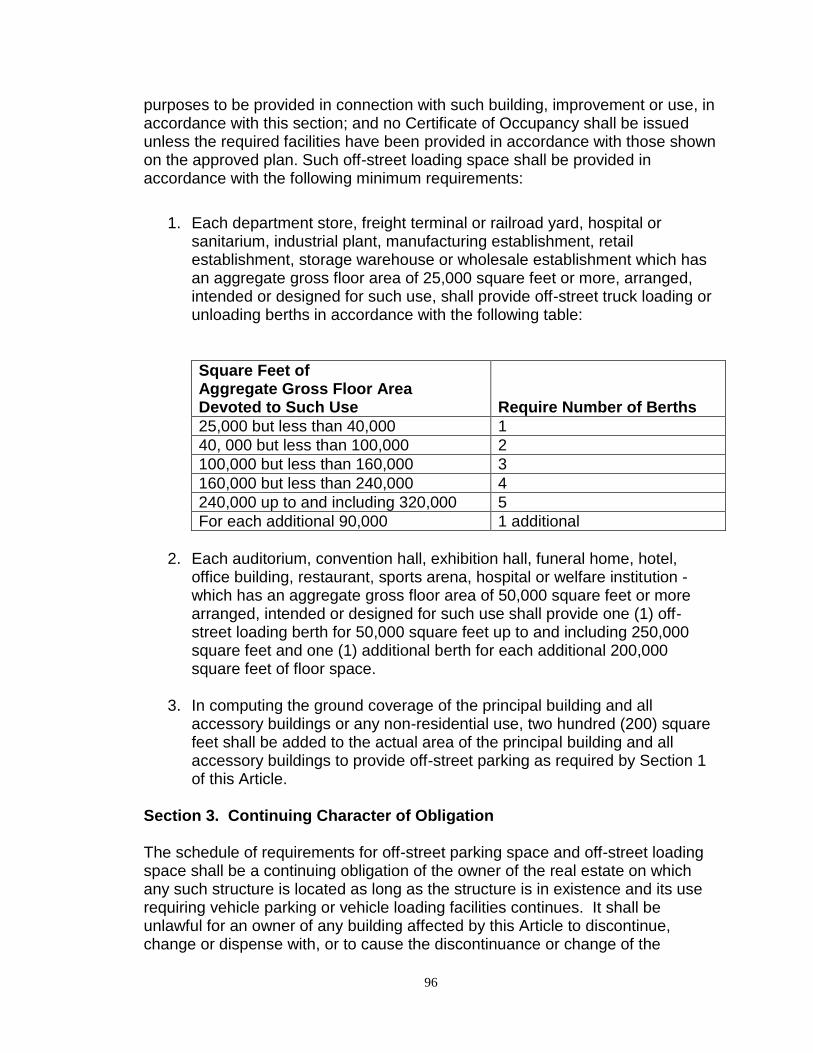
96
purposes to be provided in connection with such building, improvement or use, in accordance with this section; and no Certificate of Occupancy shall be issued unless the required facilities have been provided in accordance with those shown on the approved plan. Such off-street loading space shall be provided in accordance with the following minimum requirements:
1. Each department store, freight terminal or railroad yard, hospital or
sanitarium, industrial plant, manufacturing establishment, retail establishment, storage warehouse or wholesale establishment which has an aggregate gross floor area of 25,000 square feet or more, arranged, intended or designed for such use, shall provide off-street truck loading or unloading berths in accordance with the following table:
Square Feet of Aggregate Gross Floor Area Devoted to Such Use Require Number of Berths
25,000 but less than 40,000 1
40, 000 but less than 100,000 2
100,000 but less than 160,000 3
160,000 but less than 240,000 4
240,000 up to and including 320,000 5
For each additional 90,000 1 additional
2. Each auditorium, convention hall, exhibition hall, funeral home, hotel,
office building, restaurant, sports arena, hospital or welfare institution - which has an aggregate gross floor area of 50,000 square feet or more arranged, intended or designed for such use shall provide one (1) off-street loading berth for 50,000 square feet up to and including 250,000 square feet and one (1) additional berth for each additional 200,000 square feet of floor space.
3. In computing the ground coverage of the principal building and all
accessory buildings or any non-residential use, two hundred (200) square feet shall be added to the actual area of the principal building and all accessory buildings to provide off-street parking as required by Section 1 of this Article.
Section 3. Continuing Character of Obligation The schedule of requirements for off-street parking space and off-street loading space shall be a continuing obligation of the owner of the real estate on which any such structure is located as long as the structure is in existence and its use requiring vehicle parking or vehicle loading facilities continues. It shall be unlawful for an owner of any building affected by this Article to discontinue, change or dispense with, or to cause the discontinuance or change of the
97
required vehicle parking or loading space apart from the discontinuance, sale or transfer of such structure, without establishing alternative vehicle parking or loading space which meets with the requirements of and is in compliance with this Article. It shall be unlawful for any firm or corporation to use such building without acquiring such land or other suitable land for vehicle parking or loading space which meets with the requirements of and is in compliance with this Article.
Section 4. Fractional Measurements When units or measurements determining number of required off-street parking and off-street loading spaces result in the requirement of a fractional space, any fraction up to and including one-fourth (1/4) shall require one (1) off-street parking or off-street loading space.
Section 5. Location of Required Parking and Loading Facilities The off-street parking facilities required by this section shall be on the same lot or parcel of land as the structure they are intended to serve, however, when practical difficulties, as determined by the Board of Adjustment, prevent the establishment of such facilities upon the same lot or parcel, they shall be furnished within four hundred (400) feet of the premises to which they are appurtenant. The off-street loading facilities required by this Article shall in all cases be on the same lot or parcel of land as the structure they are intended to serve. In no case shall the required off-street loading space be part of the area used to satisfy the off-street parking requirements of this Article.
Section 6. Plan of Required Off-Street Parking or Loading For the purpose of converting parking or loading spaces into the required parking or loading area, plans must be submitted to the Building Official to show how the required parking or loading space shall be arranged in the area supplied for that purpose and to indicate sufficient space for parking maneuvers, as well as adequate ingress and egress to the parking or loading area. For each parking space, not under roof, there shall be provided two hundred (200) square feet in addition to all lanes, alleys, aisles and drives necessary for safe and adequate parking maneuvering. For each off-street loading space required by this section, there shall be provided space clear and free of all obstructions, at least ten (10) feet in width, fifty (50) feet in length, and fourteen (14) feet in height. Off-street parking and off-street loading space shall be provided with methods of ingress and egress such that it will be unnecessary for trucks or tractor-trailer combinations to back into them from a street or out of them into a street.
98
Section 7. Use of Required Off-Street Parking by Another Building No part of an off-street parking area required for any building or use for the purpose of complying with the provisions of this Article shall be included as a part of an off-street parking area similarly required for another building or use unless the type of structure indicates that the periods of usage for such structures will not be simultaneous with each other.
Section 8. Maintenance of Public Off-Street Parking Places All off-street parking facilities for the use of the public required pursuant to the provisions of this Article shall be paved, drained, lighted and periodically maintained by the owner in accordance with specifications of the County Engineer, and such facilities shall be arranged for convenient access and safety of pedestrians and vehicles. No open area in an off-street parking area shall be encroached upon by buildings, storage, or any other use; nor shall the number of parking spaces be reduced except upon the approval of the Board of Commissioners and then only after proof that, by reason of diminution in floor space, seating capacity, number of employees, or change in other factors controlling the regulation of the number of parking spaces, the proposed reduction is reasonable and consistent with the intent of this Article.
Section 9. Collective Action Relative to Off-Street Parking and Loading Nothing in this article shall be construed to prevent the joint use of off-street parking or off-street loading space for two (2) or more buildings or uses, if the total of such spaces when used together shall not be less than the sum of the requirements for the various individual uses computed separately in accordance with this Article.
Section 10. Mixed Uses In the case of mixed uses, the total requirements for off-street parking and off-street loading space shall be the sum of the requirements of the various uses computed separately as specified in Sections 1 and 2 of this Article, and the off-street parking and off-street loading space for one use shall not be considered as providing the required off-street parking or off-street loading space for any other use.
Section 11. Non-Conforming Uses In the case of nonconforming uses where major repairs, substantial alterations or extensions are made, no such major repairs, substantial alterations or extensions shall be permitted unless and until the off-street parking and off-street loading

99
facility space requirement of this Article, so far as they apply to the use to which such building is devoted, shall be fully provided for.
100
ARTICLE 11 A - AGRICULTURAL DISTRICT REGULATIONS Section 1. Description The A - Agricultural District is established as a district in which the principal use of land is for general agricultural uses. The regulations are intended to prohibit commercial and industrial usage of the land and to prohibit any other use which would interfere with the development or continuation of the agricultural use of the land; and to discourage any use, which because of its character or size, would create requirements and costs for public services such as police and fire protection, water supply, and sewerage before such services can be systematically and adequately provided. Section 2. Definition of “Farm” For the purpose of the administration of this ordinance, a "farm" shall mean a single tract, or contiguous tract, of agricultural land containing a minimum of ten (10) acres and which normally provides a farmer, who is actually farming the land or engaged in the raising of livestock or other similar operations normally associated with farming and ranching, with not less than fifty percent (50%) of his annual net income; and the term "farmer" means an individual who normally devotes the major portion of his time to the activities of producing products of the soil, poultry, livestock, or dairy farming in such products' un-manufactured state and who normally receives not less than fifty percent (50%) of his annual net income from any one or more of the foregoing activities; and the term also includes an individual who is retired because of illness or age and who at the time of retirement owned and occupied, as a farmer, the premises. Section 3. Permitted Uses The following uses are allowed by-right in the A Agricultural District:
1. Agricultural structures and activities 2. General farming group
3. Truck farming group
4. Livestock sales pavilion
5. Public recreation group
6. Utility service group
101
7. Radio or television transmitting station
8. Sand or gravel extraction
9. Oil or gas well
10. Railroad line trackage
11. Single-family dwelling 12. Manufactured home dwelling, when located on a permanent perimeter
foundation in accordance with County codes governing construction
13. Private golf course, and customary accessory uses Section 4. Special Uses The following special uses are allowed in the A-Agricultural District, in accordance with Article 8:
1. Airport or heliport 2. Cemetery
3. Drive-in theater
4. Golf driving range, not accessory to a golf course
5. Recreational vehicle park
6. Salvage yard
7. Junkyard
8. Veterinary/animal clinic
9. Animal hospital/kennel
10. Solid waste disposal facility
11. Vehicular race tracks
12. Rodeo or rodeo events
13. Trap or skeet shooting range
102
14. Animal feeding operations, as defined herein
15. Asphalt plants and concrete batch plants
16. Wind turbine facilities
17. Roadway maintenance facilities
18. Temporary worker housing
19. Meat packing facilities, limited
Section 5. Accessory Uses Customary accessory uses are allowed in the A-Agricultural District, in accordance with Article 6. Section 6. Development Standards (Non-agricultural Uses)
1. Lot Area. Each permitted residential structure, together with its accessory buildings, shall be located on a lot or tract of land as follows:
Property Description Minimum Lot/Tract Size
Metes and Bounds, Auditor’s Plat or Deed
40 acres
Aliquot part of a Section of land Intended to comprise 40 acres
Government Lot 35 acres
2. Lot Width. Each lot shall have a width of not less than six hundred-forty (640) feet, measured along the front property line.
3. Front Yard. Each lot shall have a front yard as follows, measured from the
property line:
Roadway Classifications
Minimum Front Yard (feet) Residential Buildings
Minimum Front Yard (feet) Commercial Buildings
Arterial Road 175 225
Collector Road 65 115
Local Road 40 140
4. Side Yard. Each lot shall have two (2) side yards, one on each side of all principal and accessory buildings. Each side yard shall not be less than
103
fifteen (15) feet. No building on a corner lot shall have a side yard on the side street less than the front yard requirements specified in this section.
5. Rear Yard. Each lot shall have a rear yard not less than fifty (50) feet in
depth. If such rear yard abuts an arterial or collector road right-of- way, building locations shall also conform to the front yard requirements specified in this section.
6. Height Limits. No principal building for any permitted use shall exceed
thirty-five (35) feet in height. No accessory building shall exceed twenty-five (25) feet in height.
7. Residential Building Permit. A building permit to construct or improve a
single family or manufactured home dwelling and allowed accessory buildings shall be issued only after the following conditions have been met:
a. An auditor’s plat or a deed describing the property has been
prepared and recorded at the Register of Deed’s Office. b. A road approach permit has been granted by the County Engineer.
8. Non-residential Building Permit. A building permit to construct or improve
any other non-agricultural building shall be issued only if such building is located in a platted subdivision.
Section 7. Additional Development Standards for Land Abutting the
Missouri River (Non-agricultural uses)
In order to preserve and enhance the environmental and recreational qualities of the Missouri River, conserve the scenic and historic values of the Missouri River shoreland, protect shoreland development from river bank erosion, and provide for the wise use of the river and related land resources, the following additional development standard for non-agricultural uses is hereby established for land abutting the Missouri River:
1. Structure Setbacks. All structures on lots or parcels with unstablized
banks shall be set back a minimum of one hundred (100) feet from the ordinary high water mark of the Missouri River. All structures on lots or parcels with stabilized banks, either by an existing Corps of Engineers’ stabilized structure or as permitted and approved by the Corps of Engineers, shall be set back a minimum of seventy-five (75) feet from the ordinary high water mark of the Missouri River.
104
ARTICLE 12 R1 COUNTRY HOMES RESIDENTIAL DISTRICT REGULATIONS Section 1. General Description The R1 County Homes Residential District is established as a district in which the predominant use of land is for low-density residential and limited agricultural use. For the R1 District, in promoting the general purposes of this Ordinance, the specific intent of this Article is to encourage the continued use of the land for low-density residential and limited agricultural uses; prohibit commercial and industrial uses of the land; discourage any use, which because of its character or size, would create unusual requirements and costs for public services; and provide special standards for residential development abutting the Missouri River. Section 2. Uses Permitted The following uses are allowed by-right in the R1 Country Homes Residential District:
1. Single-family dwellings
2. Education group
3. Church
4. Utility service group
5. Public recreation group
6. Truck-farming group
7. Animal husbandry activity or project conducted primarily for educational purposes or school credits, provided such activities are not conducted for commercial purposes, and premises are maintained in a sanitary manner
8. Private riding stables provided that animals shall be used for private use
only; that no animal, animal stable, barn or shelter shall be located within one hundred (100) feet of any neighboring residence or structure; that two (2) horses shall be permitted on any premises which contains at least two (2) acres and additional horses shall be allowed at the rate of one (1) horse for every additional three (3) acres of property owned
9. Golf course.
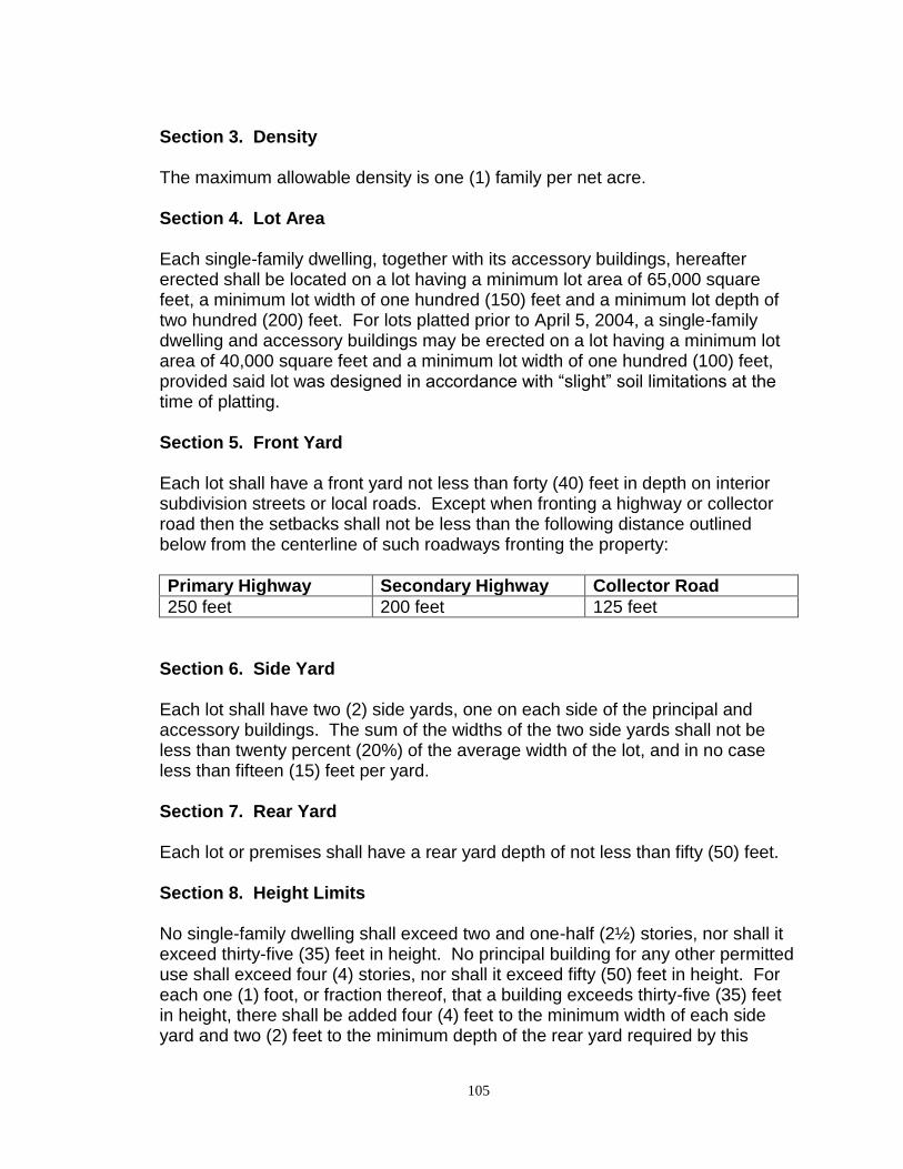
105
Section 3. Density The maximum allowable density is one (1) family per net acre. Section 4. Lot Area Each single-family dwelling, together with its accessory buildings, hereafter erected shall be located on a lot having a minimum lot area of 65,000 square feet, a minimum lot width of one hundred (150) feet and a minimum lot depth of two hundred (200) feet. For lots platted prior to April 5, 2004, a single-family dwelling and accessory buildings may be erected on a lot having a minimum lot area of 40,000 square feet and a minimum lot width of one hundred (100) feet, provided said lot was designed in accordance with “slight” soil limitations at the time of platting. Section 5. Front Yard Each lot shall have a front yard not less than forty (40) feet in depth on interior subdivision streets or local roads. Except when fronting a highway or collector road then the setbacks shall not be less than the following distance outlined below from the centerline of such roadways fronting the property:
Primary Highway Secondary Highway Collector Road
250 feet 200 feet 125 feet
Section 6. Side Yard Each lot shall have two (2) side yards, one on each side of the principal and accessory buildings. The sum of the widths of the two side yards shall not be less than twenty percent (20%) of the average width of the lot, and in no case less than fifteen (15) feet per yard. Section 7. Rear Yard Each lot or premises shall have a rear yard depth of not less than fifty (50) feet. Section 8. Height Limits No single-family dwelling shall exceed two and one-half (2½) stories, nor shall it exceed thirty-five (35) feet in height. No principal building for any other permitted use shall exceed four (4) stories, nor shall it exceed fifty (50) feet in height. For each one (1) foot, or fraction thereof, that a building exceeds thirty-five (35) feet in height, there shall be added four (4) feet to the minimum width of each side yard and two (2) feet to the minimum depth of the rear yard required by this
106
section. No accessory building shall exceed two (2) stories, nor shall it exceed twenty-five (25) feet in height. Section 9. Automobile Parking Adequate automobile parking shall be provided as set forth in Article 10 of this Ordinance. Section 10. Minimum Road Standards Unless otherwise shown on the master plan, right-of-way and roadway widths shall conform to the standards set forth by Section 6, Subsection 1(m) of Article 33 hereof.
1. Sufficient temporary construction easements shall be given to allow for proper road construction.
2. All streets to be used for on-street parking shall be forty (40) feet in
roadway width. Section 11. Allowable Accessory Buildings Customary accessory uses are allowed in the R1 Residential District in accordance with Article 6. Section 12. Additional Development Standards for Land Abutting the
Missouri River
In order to preserve and enhance the environmental and recreational qualities of the Missouri River, conserve the scenic and historic values of the Missouri River shoreland, protect shoreland development from river bank erosion, and provide for the wise use of the river and related land resources, the following additional development standards are hereby established for land abutting the Missouri River platted after January 1, 2003:
1. Structure Setbacks. All structures on lots with unstablized banks shall be
set back a minimum of one hundred (100) feet from the ordinary high water mark of the Missouri River. All structures on lots with stabilized banks, either by an existing Corps of Engineers’ stabilized structure or as permitted and approved by the Corps of Engineers, shall be set back a minimum of seventy-five (75) feet from the ordinary high water mark of the Missouri River.
2. Impervious Surface Coverage. The percentage of the lot covered by
impervious surfaces (structures, paved surfaces, etc) shall not exceed 25 percent (25%).
107
3. Steep Slopes. For structures and/or facilities to be placed on steep
slopes, the County Building Official may attach conditions on the building permit to prevent erosion and preserve existing vegetation.
4. Topographic Alterations Above the Ordinary High Water Mark. Grading, filling and excavation necessary for the construction of structures, sewage treatment systems or driveways under validly issued permits shall be allowed. Notwithstanding any other applicable regulations, any other topographic alterations must meet the following standards: 1) alterations shall not adversely affect adjacent or nearby properties; and 2) alterations must be designed and constructed in a manner that minimizes soil erosion, including the installation of erosion control measures as needed.
5. Topographic Alterations Below the Ordinary High Water Mark. All topographic alterations below the ordinary high water mark must be approved by the Corps of Engineers.
6. Variances. It is not the intent of this ordinance to make an existing parcel or lot, which is developable under the regulations in place prior to the adoption of this ordinance, not developable. Variances from the strict application of these development standards shall be subject to the requirements of Article 28.
108
ARTICLE 13 R2 SINGLE-FAMILY RESIDENTIAL DISTRICT REGULATIONS Section 1. General Description The R2 Residential District is established as a district in which the principal use of the land is for medium density single-family dwellings on rural lots, provided said lots are not located abutting the Missouri River. The regulations are intended to prohibit commercial or industrial use of the land and to prohibit any other use which would substantially interfere with the development or continuation of single-family residential neighborhoods; and to discourage any use which because of its character or size would create requirements and costs for public services, such as police and fire protection, water supply, and sewerage, before such services can be systematically and adequately provided. Section 2. Permitted Uses The following uses are allowed by-right in the R2 Residential District:
1. Single-family dwellings 2. Education group
3. Utility service group
4. Public recreation group
5. Golf course
Section 3. Special Uses The following special uses are allowed in the R2 Residential District, in accordance with Article 8:
1. Airport 2. Cemetery
Section 4. Accessory Uses Customary accessory uses are allowed in the R2 Residential District, in accordance with Article 6.
109
Section 5. Development Standards
1. Density. The maximum allowable density is two (2) families per net acre.
2. Lot Area. Each permitted structure, together with its accessory buildings, shall be located on a lot having an area not less than twenty thousand (20,000) square feet in size.
3. Lot Width. Each lot shall have a width of not less than eighty (80) feet as
measured along the front setback line.
4. Lot Depth. Each lot shall have a depth of not less than one hundred-twenty (120) feet.
5. Lot Coverage. The ground area occupied by the principal and accessory buildings shall not exceed thirty percent (30%) of the total area of the lot. In computing lot coverage, off-street parking areas complying with Article 10, Section 1 of this Ordinance shall be added to the actual area of the buildings, if such parking space is not furnished within a building.
6. Front Yard. Each lot shall have a front yard not less than thirty (30) feet in
depth. No lot shall be designed to front on any county, state or federal highway.
7. Side Yard. Each lot shall have two (2) side yards, one on each side of all
principal and accessory buildings. Each side yard shall not be less than fifteen (15) feet.
8. Rear Yard. Each lot shall conform to the following rear yard standards:
not less than (30) feet for principal buildings and not less than fifteen (15) feet for accessory buildings.
9. Height Limits. No principal building shall exceed forty (40) feet in height.
No accessory building shall exceed twenty-five (25) feet in height.
10. Parking. Off-street parking shall be provided in accordance with Article 10, Section 1 of this Ordinance.
11. Central Sewer System. All lots shall be served by a central sanitary sewer
system approved by the North Dakota State Department of Health.
110
ARTICLE 14 R3 SINGLE/TWO-FAMILY RESIDENTIAL DISTRICT REGULATIONS Section 1. Description The R3 Residential District is established as a district in which the principal use of the land is for medium density single-family and two-family dwellings on rural lots, provided said lots are not located abutting the Missouri River. The regulations are intended to prohibit commercial or industrial use of the land and to prohibit any other use which would substantially interfere with the development or continuation of single-family and two-family residential neighborhoods; and to discourage any use which because of its character or size would create requirements and costs for public services, such as police and fire protection, water supply, and sewerage, before such services can be systematically and adequately provided. Section 2. Permitted Uses The following uses are allowed by-right in the R3 Residential District:
1. Single-family dwellings 2. Two-family dwellings
3. Education group
4. Utility service group
5. Public recreation group 6. Golf course
Section 3. Special Uses The following special uses are allowed in the R3 Residential District, in accordance with Article 8:
1. Airport 2. Cemetery
111
Section 4. Accessory Uses Customary accessory uses are allowed in the R3-Residential District, in accordance with Article 6. Section 5. Development Standards
1. Density. The maximum allowable density is four (4) families per net acre. 2. Lot Area. Each permitted structure, together with its accessory buildings,
shall be located on a lot having an area not less than twenty thousand (20,000) square feet in size.
3. Lot Width. Each lot shall have a width of not less than eighty (80) feet as
measured along the front setback line.
4. Lot Depth. Each lot shall have a depth of not less than one hundred-twenty (120) feet.
5. Lot Coverage. The ground area occupied by the principal and accessory
buildings shall not exceed thirty percent (30%) of the total area of the lot. In computing lot coverage, off-street parking areas complying with Article 10, Section 1 of this Ordinance shall be added to the actual area of the buildings, if such parking space is not furnished within a building.
6. Front Yard. Each lot shall have a front yard not less than thirty (30) feet in
depth. No lot shall be designed to front on any county, state or federal highway.
7. Side Yard. Each lot shall have two (2) side yards, one on each side of all
principal and accessory buildings. Each side yard shall not be less than fifteen (15) feet.
8. Rear Yard. Each lot shall conform to the following rear yard standards:
not less than thirty (30) feet for principal buildings and not less than fifteen (15) feet for accessory buildings.
9. Height Limits. No principal building shall exceed forty (40) feet in height.
No accessory building shall exceed twenty-five (25) feet in height.
10. Parking. Off-street parking shall be provided in accordance with Article 10, Section 1 of this ordinance.
11. Central Sewer System. All lots shall be served by a central sanitary sewer
system approved by the North Dakota State Department of Health.
112
Section 6. Two-family Building Standards Construction of two-family residential dwellings shall be subject to the following limitations:
1. Such dwellings shall be attached side-by-side structures in groups of two (2), separated by a two-hour area separation wall constructed in accordance with the building code.

113
ARTICLE 14.1
Repealed by Ordinance 13-09
114
ARTICLE 15 R5 MOBILE HOME PARK RESIDENTIAL DISTRICT REGULATIONS Section 1. General Description The R5 Residential District is established as a district in which the principal use of the land is for single-family mobile home dwellings located within mobile home parks, provided said parks are not located abutting the Missouri River. For the R5 Residential District, the specific intent of this Article is:
1. To encourage the placement of, and the continued use of the and for single-family mobile home dwellings located within mobile home parks;
2. To prohibit commercial and industrial use of the land; and
3. To encourage suitable and proper development of mobile home parks. Section 2. Definition For the purpose of this section, "Mobile Home Park" shall also mean "Mobile Home Court". Section 3. Uses Permitted The following uses are allowed by-right in the R5 Residential District:
1. Single-family mobile home dwellings or manufactured homes not located on a permanent foundation located within mobile/manufactured home parks.
2. Home occupations of
a. Dressmaker b. Artist c. Sculptor d. Author e. Minister
Section 4. Density The maximum allowable density of all mobile home parks shall be seven (7) families per net acre.
115
Section 5. Lot Dimensions
1. For single-wide mobile home dwelling units, minimum lot dimensions shall be fifty (50) feet wide and one hundred (100) feet deep with a minimum lot area of five thousand (5,000) square feet.
2. For double-wide mobile home dwelling units, minimum lot dimensions
shall be sixty (60) feet wide and one hundred (100) feet deep with a minimum lot area of six thousand (6,000) square feet.
Section 6. Lot Coverage
1. The ground area occupied by a mobile home, attached storm shed, patio, storage building and off-street parking spaces shall not exceed 50 percent (50%) of the total area of the lot. In computing the ground coverage, four hundred (400) square feet shall be added to the actual area of the mobile home and the accessory buildings for the two (2) required off-street parking spaces. This provision limits a lot to one (1) storm shed, not over ten (10) feet by twelve (12) feet, or one hundred twenty (120) square feet, in area per lot, and said building shall be placed on a proper foundation.
2. No mobile home, storm shed, or other legal attachments to said mobile
home shall be located less than seven (7) feet six (6) inches from a side lot line. Detached toolsheds shall be located not less than five (5) feet from side or rear lot lines. The ends of a mobile home shall be at least ten (10) feet apart when opposing rear walls are staggered, otherwise fifteen (15) feet apart.
Section 7. Lot Restrictions All clotheslines shall be placed in the rear yard. Section 8. Mobile Home Park Requirements
1. The minimum total area of a mobile home park shall be at least four (4) acres.
2. The minimum street or roadway on which each mobile home fronts shall
be at least thirty (30) feet from curb-to-curb in width, if automobile parking is limited to one side; and forty (40) feet from curb-to-curb if automobile parking is allowed on both sides. Dead end streets shall not exceed one hundred seventy-five (175) feet in length. Turning circles shall be at least eighty (80) feet in diameter.
3. All entrances, exits and driveways between rows of mobile homes shall be
lighted to provide an intensity of 0.3 foot-candles. Mobile home parks
116
shall be provided with walkways at least three and one-half (3½) feet wide between each mobile home lot and service building and other parts of said park. Roadways within the parks shall be hard-surfaced, either concrete or bituminized.
4. All provisions of water supply, laundry, sewage and fire protection to be
provided in any mobile home park shall have been approved by the appropriate County and State Departments.
5. Off-street parking areas shall be provided in all mobile home parks at a
ratio of at least two (2) car spaces per mobile space. The area for one (1) car space shall be at least ten (10) feet wide and twenty (20) feet deep, plus ingress and egress.
6. Recreation Areas. There shall be provided within each mobile home park
an adequate site or sites for recreation for the exclusive use of the park occupants. Such recreation site or sites shall have a minimum area in the aggregate of four thousand (4,000) square feet plus one hundred (100) feet for each mobile home space in said park. The recreation sites shall be of appropriate design and provided with adequate and permanent equipment.
7. All mobile home parks must provide a completely and permanently
landscaped setback area of at least thirty (30) feet in width around those portions of the park perimeter which border public right-of-way. Such areas may contain trees, shrubbery, grass, benches, fences, landscaped water resources and the like.
8. Setback areas not bordering public right-of-way may be used to fulfill the
recreation area requirements of the preceding paragraph.
9. All mobile home parks shall have near their main entrance a park office in which there shall be an up-to-date list of all park residents along with their addresses and a diagram of the park lay-out.
10. All mobile home park lots shall be served by an approved central water
and sewer system. Section 9. Mobile Home Park Restrictions
1. No business shall be conducted in any mobile home park. 2. Existing mobile home parks shall not be enlarged or extensively altered
unless such alteration complies with the provisions of this article.
117
Section 10. Mobile Home Parks, Plans and Layout All lay-outs for mobile home parks shall be submitted to the Planning Commission for approval prior to consideration of a zoning change request for R5 District uses. All changes thereto must be approved in like manner. Section 11. Mobile Home Requirements
1. All mobile homes shall be equipped with compatible skirts to completely enclose the underside of the mobile home.
2. Each mobile home shall be anchored to the ground for purposes of
withstanding wind pressures specified for single-family dwellings by the County Building Inspection Department prior to occupancy of the unit.

118
ARTICLE 16 C - COMMERCIAL DISTRICT REGULATIONS Section 1. General Description The C - Commercial District is established as a district in which the principal use of land is for commercial and service uses to serve the residential districts in the area, provided said uses are not located abutting the Missouri River, and in which traffic and parking congestion can be kept to a minimum in order to preserve residential values, and promote the general welfare of the surrounding residential district. The specific intent of this Article is:
1. To encourage the continued use of the land for neighborhood commercial and services uses;
2. To prohibit industrial uses of the land, and to prohibit any other use which
would substantially depreciate the values of residential districts surrounding the C - Commercial District;
3. To encourage the discontinuance of mixed uses and uses that would not
be permitted as new uses under the provisions of this article;
4. To discourage any use, which because of its character or size, would create requirements and costs for public services, such as police and fire protection, water supply and sewerage substantially in excess if the district were developed solely for neighborhood commercial and service uses.
Section 2. Uses Permitted The following uses are allowed by-right in the C - Commercial District:
1. Retail Group A 2. Service Group A
3. Gasoline Filling Station
4. Office-bank Group
5. Church
6. Education Group
7. Fire Station
119
8. Utility Service Group
9. Retail Group B
10. Service Group B
11. Commercial Recreation Group
12. Wholesale Group
13. Health Medical Group
14. Public Recreation Group
15. Railroad Line Trackage
16. Railroad or Bus Passenger Station
17. Animal Hospital
18. Commercial Parking Lot Section 3. District Area No C - Commercial District shall be less than five (5) acres in size. Section 4. Lot Area Each principal building or structure plus its accessory buildings shall be located on a lot having an area as specified in Article 33, Section 6 (4) of the Zoning Ordinance. In no case shall a lot be less than twenty thousand (20,000) square feet in size. Premises without a central sanitary sewer system approved by the North Dakota State Department of Health shall comply with lot area requirements of the R1 Residential District.
Section 5. District Width Each C District shall have an average width of not less than two hundred (200) feet and shall have no boundary less than one hundred (100) feet in length.
Section 6. Floor Area Ratio The floor area ratio of the principal building and all accessory buildings shall not exceed 0.25 for a single-story building, nor shall it exceed 0.35 for buildings of more than one story. The ground area occupied by the principal building and
120
accessory buildings shall not exceed twenty-five percent (25%) of the total area of the lot.
Section 7. Yard No building shall be less than fifty (50) feet in distance from any lot line or twenty (20) feet in distance from any side or back yard line.
Section 8. Height Limits No building or structure shall exceed two (2) stories or thirty-five (35) feet in height.
Section 9. Divided District For the purposes of calculating the minimum area, lot width, lot dimensions, floor area ratio, percentage of lot covered by building, and yard requirements established by this Article, a single C - Commercial District cannot lie on two (2) sides of a public street or alley. Any area designated as being zoned C - Commercial and lying on both sides of a public street or alley shall be deemed to be two (2) C Commercial Districts, and all minimum requirements shall be met by buildings on each side of said public street or alley as separate districts.
Section 10. Non-Conforming Uses It is the intent of this Article and this Section to designate no area as a C Commercial District in which there is at the date of adoption of this Article any residential or other non-conforming use. It is the further intent of this Article and this section that insofar as possible all neighborhood commercial and service areas in newly developed portions of the County shall take place in a C Commercial District, in order to decrease traffic and parking congestion and to preserve the residential values of the County. The County Planning and Zoning Commission shall refuse to approve any request for an amendment re-zoning any portion of the County to a C - Commercial District if there is in that district any use which would be a non-conforming use upon the passage by the Board of County Commissioners of the proposed amendment. Section 11. Automobile Parking Adequate automobile parking shall be provided as set forth in Article 10 of this Ordinance.

121
ARTICLE 17
Repealed by Ordinance 13-09
122
ARTICLE 18 I - INDUSTRIAL DISTRICT REGULATIONS Section 1. General Description The I - Industrial District is established as a district in which the principal use of land is for heavy commercial, manufacturing and industrial establishments, provided said uses are not located abutting the Missouri River, which may create some nuisance, and which are not properly associated with, nor compatible with, residential, institutional, neighborhood commercial, and service establishments. For the Industrial District, in promoting the general purposes of this Ordinance, the specific intent of this Article is:
1. To encourage the construction of and the continued use of the land for
heavy commercial, manufacturing and industrial purposes;
2. To prohibit residential and neighborhood commercial use of the land and to prohibit any other use which would substantially interfere with the development, continuation or expansion of commercial and industrial uses in the district; and
3. To encourage the discontinuance of existing uses that would not be
permitted as new uses under the provisions of this article. Section 2. Uses Permitted The following uses are allowed by-right in the I Industrial District:
1. Gasoline filling station 2. Retail group B
3. Service group B
4. Wholesale group
5. Fire Station
6. Truck terminal
7. Railroad line trackage
8. Railroad spur trackage
123
9. Railroad freight station
10. Railroad freight classification yard
11. Utility service group
12. Industrial use group 13. Livestock sales pavilion
14. Oil or gas well
15. Radio or television transmitting station
16. Sand or gravel extraction
17. Sewage treatment plant
18. Manufacturing Group
Section 3. Special Uses The following special uses are allowed in the I - Industrial District, in accordance with Article 8:
1. Meat packing facilities
Section 4. Lot Area Each principal building or structure plus its accessory buildings, shall be located on a lot having an area as specified in Article 33, Section 6(4) of the Zoning Ordinance. In no case shall a lot be less than twenty thousand (20,000) square feet in size. Premises without a central sanitary sewer system approved by the North Dakota State Department of Health shall comply with lot area requirements of the R1 Residential District. Section 5. Lot Width Each lot shall have a width of not less than one hundred (100) feet, measured along the front building line. Section 6. Floor Area Ratio Floor area ratio of the principal buildings or building and all accessory buildings shall not exceed 0.30 for single-story buildings, nor shall it exceed 0.60 for
124
buildings of more than one story. The ground area occupied by the principal building or buildings and accessory buildings shall not exceed thirty percent (30%) of the total area of the lot. Section 7. Front Yards Each building shall have a front yard not less than fifty (50) feet in depth. Section 8. Side Yards Each lot shall have two (2) side yards, one on each side of any principal building. The sum of the widths of the two (2) side yards shall be not less than twenty percent (20%) of the average width of the lot; and in no case shall a side yard be less than fifteen (15) feet in width. On any lot having an average width greater than seventy-five (75) feet, neither side yard shall be less than fifteen (15) feet in width and no side yard need be greater than fifty (50) feet in width. On a lot containing two (2) principal buildings located side by side, there are no minimum requirements for the side yards between the two (2) buildings. Section 9. Rear Yards Each lot shall have a rear yard not less than twenty-five (25) feet in depth. Section 10. Height Limits No principal buildings shall exceed four (4) stories, nor shall it exceed fifty (50) feet in height. No accessory buildings shall exceed two (2) stories, nor shall it exceed twenty-five (25) feet in height. Section 11. Automobile Parking Adequate automobile parking shall be provided as set forth in Article 10 of this Ordinance. Section 12. Landscaping All front, side and rear yards shall be permanently landscaped.

125
ARTICLE 19 Repealed by Ordinance 13-09
126
ARTICLE 20 PUD - PLANNED UNIT DEVELOPMENT DISTRICT REGULATIONS Section 1. Intent It is the intent of this Article to encourage flexibility in development of land in order to promote its most appropriate use; to improve the design, character and quality of new development; to facilitate the adequate and economical provision of streets and utilities; and to preserve the natural and scenic features of open space. It is also the intent of this Article to provide for flexibility in the development of land abutting the Missouri River. Residential development abutting the Missouri River with dwelling unit densities in excess of that allowed by the underlying zoning district, and any development abutting the Missouri River with a commercial or industrial component, may only be allowed if designed and approved in accordance with the provisions of this Article. Section 2. Application An application for approval of a planned unit may be filed by a person having an interest in the property to be included in the planned unit. The application will be made on a form provided by the County and must include a consent by the owners of all property to be included in the planned unit. The application must be accompanied by a site plan and a written statement.
1. Site Plan.
A complete site plan showing the major details of the proposed planned unit prepared at a scale of not less than one (1) inch equals one hundred (100) feet shall be submitted in sufficient detail to evaluate the land planning, building design, and other features of the planned unit. The site plan must contain insofar as applicable, the following minimum information:
a. The existing topographic character of the land; b. Proposed land uses; c. The general location of all existing and proposed buildings,
structures and improvements; d. The maximum height of all buildings; e. The density and type of dwellings; f. The internal traffic and circulation systems, off-street parking areas,
and major points of access to public rights-of-way; g. Areas which are to be conveyed, dedicated or reserved as common
park areas, including public parks and recreational areas;
127
h. Proposed interior buffer areas between uses; i. Acreage of PUD; j. Utility service plan showing existing utilities in place and all existing
and proposed easements; k. Landscape plan; and l. Surrounding land uses, zoning and ownership.
2. Written Statement
The written statement to be submitted with the planned unit application must contain the following information:
a. A statement of the present ownership and a legal description of all
the land included in the planned unit; b. An explanation of the objectives to be achieved by the planned unit,
including building descriptions, sketches or elevations as may be required to describe the objectives; and
c. A copy of all proposed association agreements for common areas.
3. Architectural Drawings
The following architectural drawings shall be submitted in sufficient detail to allow evaluation of building height, form, massing, texture, materials of construction, and type, size and location of door and window openings:
a. Elevations of the front and one side of a typical structure; and b. A perspective of a typical structure, unless waived by the Planning
Department.
4. The applicant may submit any other information or exhibits he deems pertinent in evaluating his proposed planned unit.
Section 3. Review and Approval
1. All planned units shall be considered by the Planning and Zoning Commission in the same manner as a zoning change. The Planning and Zoning Commission may grant the proposed planned unit in whole or in part, with or without modifications and conditions, or deny it.
2. All approved site plans for planned units, including modifications or
conditions shall be endorsed by the Planning and Zoning Commission and filed with the Planning Director, who shall indicate on the zoning district map that a planned unit has been approved for the area included in the site plan.
128
Section 4. Standards The Planning and Zoning Commission must be satisfied that the site plan for the planned unit has met each of the following criteria or can demonstrate that one or more of them is not applicable, and that a practicable solution consistent with the public interest has been achieved for each of these elements:
1. Proposal conforms to the comprehensive plan.
2. There must be an appropriate relationship to the surrounding area and
there must be a minimum thirty (30) foot buffer zone in any planned unit of multi-family or non-residential buildings or structures adjacent to a low-density residential use district. The buffer zone must be kept free of buildings, or structures and must be landscaped, screened, or protected by natural features, so that adverse effects on surrounding areas are minimized.
3. Optimum preservation of natural features including trees and drainage
areas must be accomplished.
4. The internal street circulation system must be designed for the type of traffic generated. Private internal streets may be permitted if they can be used by police and fire department vehicles for emergency purposes.
5. Pedestrian travel routes must be safe, convenient and attractive.
6. The maximum allowable density shall not exceed twelve (12) families per
net acre. Section 5. Changes
1. Minor changes in the location, setting, or character of buildings and structures may be authorized by the Planning Director, if required by engineering or other circumstances not foreseen at the time the planned unit is approved.
2. All other changes in the planned unit must be made under the procedures
that are applicable to the initial approval of the planned unit. Section 6. Subdivision and Resale A planned unit may be subdivided or re-subdivided for purposes of sale or lease if such action does not increase the dwelling unit density of the planned unit and if the planned unit, following the subdivision or re-subdivision, is in compliance with the standards for planned units provided in this section.
129
ARTICLE 20.1 P - PUBLIC USE DISTRICT REGULATIONS Section 1. General Description
The P Public Use District is established as a district in which the principal use of the land is for governmental, civic or institutional uses, including major public facilities. The regulations are intended to prohibit any other use which would diminish its value in serving the needs of the public. The P - Public Use District offers an alternative zoning classification for public and institutional uses, thereby increasing development predictability. Section 2. Permitted Uses
The following uses are allowed by-right in the P - Public Use District:
1. Education group
2. Public recreation group
3. Water treatment plant
4. Buildings and necessary on-site facilities required for the conduct of government, including roadway maintenance facilities
5. Commercial recreation group occupying public owned land
6. Sewerage treatment plant
7. Parking lots
8. Utility service groups
9. Private golf course, and customary accessory uses
Section 3. Special Uses The following special uses are allowed in the P Public District, in accordance with Article 8:
1. Airport
2. Cemetery
130
3. Golf driving range, not accessory to a golf course
4. Solid waste disposal facility
5. Vehicle racetrack
6. Rodeos or rodeo events
Section 4. Development Standards All building and yard regulations shall be the same as for the R1 Country Homes Residential District.
131
ARTICLE 21 FP - FLOODPLAIN DISTRICT REGULATIONS In any FP - floodplain district, the following regulations shall apply: Section 1. Statement of Purpose. It is the purpose of this article to promote the public health, safety, and general welfare, and to minimize public and private losses due to flood conditions in specific areas by provisions designed:
a. To protect human life and health; b. To minimize expenditure of public money for costly flood control projects; c. To minimize the need for rescue and relief efforts associated with
flooding, generally undertaken at the expense of the general public; d. To minimize prolonged business interruptions; e. To minimize damage to public facilities and utilities located in special
flood hazard areas such as water and gas mains, electric, telephone, and sewer lines, streets, and bridges;
f. To help maintain a stable tax base by providing for the use and
development of special flood hazard areas so as to minimize future flood blight areas;
g. To ensure that potential buyers are notified that property is located in a
special flood hazard area; h. To ensure that those who occupy the special flood hazard areas assume
responsibility for their actions; and i. To provide an increased level of protection in anticipation of future
increases in the base flood elevation (BFE). Section 2. Methods of Reducing Flood Losses. In order to accomplish its purposes, this article includes methods and provisions for:
132
a. Restricting or prohibiting uses which are dangerous to health, safety, and property due to water or erosion hazards, or which result in damaging increases in erosion, flood water elevations or flow velocities;
b. Requiring that uses vulnerable to flooding, including attendant utilities
and facilities which serve such uses, be protected against flood damage at the time of initial construction;
c. Controlling the alteration of natural floodplains, stream channels, and
natural protective barriers, which help accommodate or convey flood waters;
d. Controlling filling, grading, dredging, and other development which may
increase flood damage; and e. Preventing or regulating the construction of flood barriers which will
unnaturally divert flood waters or which may increase flood hazards in other areas.
Section 3. Definitions.
Unless specifically defined below, words or phrases used in this article shall be interpreted so as to give them the meaning they have in common usage and to give this article its most reasonable application.
"Appeal" means a request for a review of the Floodplain Administrator’s interpretation of any provision of this article or a request for a variance. “Attendant utilities and equipment” means utilities, electrical, plumbing, heating, ventilation, and air conditioning equipment, as well as facilities and services associated with new construction.
"Base flood or 100-year flood" means the flood having a one per cent (1%) chance of being equaled or exceeded in any given year.
“Base flood elevation (BFE)” means the height of the base flood or 100-year flood, usually in feet above mean sea level, as designated on a FEMA published digital flood insurance rate map (DFIRM) or as determined by the storm water management plan prepared for the area in which the property is located. “Basement” means any area of a building having its floor subgrade (below ground level) on all sides. “Best available data (BAD)” means water elevation information from any source used to estimate or determine the base flood elevation (ie, high water mark).
133
“Conveyance or hydraulic conveyance” means a geometric characteristic of a river or watercourse at a given location that determines the flow-carrying capacity at that location. "Development" means any man-made change to improved or unimproved real estate, including but not limited to buildings or other structures, mining, dredging, filling, grading, paving, excavation or drilling operations located within the special flood hazard area.
“Fill” means materials such as soil, gravel, or crushed stone that is placed in an area and increases the ground elevation, whether or not that was the intention. "Flood or flooding" means a general and temporary condition of partial or complete inundation of normally dry land areas from: a. The overflow of inland or tidal waters; and/or b. The unusual and rapid accumulation or runoff of surface waters from any source.
"Flood insurance rate map" (FIRM) or digital flood insurance rate map (DFIRM)” means the official map issued by the Federal Emergency Management Agency (FEMA) where special flood hazards areas are designated as Zone A, AE, AO, AH, A1-A30 or A99.
"Flood insurance study (FIS)" means the official report provided by the Federal Emergency Management Agency (FEMA) that includes flood profiles, the flood insurance rate map (FIRM), and the water surface elevation of the base flood. “Floodplain or flood-prone area” means any land area susceptible to partial or complete inundation by water from any source. "Floodplain Administrator" means the person designated by Burleigh County to administer the County’s floodplain regulations. “Flood proofing (dry)” means protection provided a structure, together with attendant utilities and sanitary facilities, which is watertight to two (2) feet above the base flood elevation with walls that are substantially impermeable to the passage of water. "Floodway or regulatory floodway" means the channel of a river or other watercourse and the adjacent land areas that must be reserved in order to discharge the base flood without cumulatively increasing the
134
water surface elevation more than one (1) foot. “Letter of map amendment (LOMA)” means an official amendment to the currently effective flood insurance rate map (FIRM) which establishes that a property is not located in a special flood hazard area. A letter of map amendment (LOMA) is issued by FEMA. “Letter of map revision (LOMR)” means an official amendment to the currently effective flood insurance rate map (FIRM) which is issued by FEMA and changes flood zones, delineations and elevations. A letter of map revision based on fill (LOMR)(f)) is a LOMR issued by FEMA based on the placement of fill. "Lowest floor" means the lowest floor of a structure including the basement and/or crawl space. "Manufactured home" means a structure transportable in one or more sections, which is built on a permanent chassis, and is designed for use with or without a permanent foundation when connected to the required utilities. The term “manufactured home” does not include a recreational vehicle, but does include a mobile home.
"Manufactured home park or subdivision" means a parcel (or contiguous parcels) of land divided into two (2) or more manufactured home lots for rent or sale.
"New construction" means structures for which the "start of construction" commenced on or after the effective date of this article.
"Non-residential” means any building or structure or portion thereof that is not classified as residential.
“Reasonably safe from flooding” means base flood waters will not inundate the land or damage structures to be removed from the special flood hazard area, and that any subsurface waters related to the base flood will not damage existing or proposed buildings.
“Recreational vehicle” means a vehicle which is built on a single chassis; four hundred (400) square feet or less when measured at the largest horizontal projection; designed to be self-propelled or permanently towable by a light duty truck; and designed primarily not for use as a permanent dwelling but as temporary living quarters for recreational camping, travel, or seasonal uses. Recreational vehicles include, but are not limited to, travel trailers, trailers on wheels, park-model trailers and other similar vehicles.
135
“Residential” means:
a. Buildings and structures and portions thereof where people live or that are used for sleeping purposes on a transient or non-transient basis;
b. Residential structures, including but not limited to one and two-family dwellings, multifamily dwellings, group dwellings, bed and breakfast facilities, hotels and motels; and
c. Institutional facilities where people are cared for or live on a 24-hour basis in a supervised environment, including but not limited to board and care facilities, assisted living facilities, nursing homes, group homes, congregate care facilities, hospitals, medical centers, jails and detention centers.
"Special flood hazard area (SFHA)" means an area of land that would be inundated by a flood having two tenths of one percent (0.2%) or greater chance of being equaled or exceeded in any given year (500-year flood). "Start of construction" includes substantial improvement, and means the date the building permit was issued, provided the actual start of construction, repair, reconstruction, placement, or other improvement was within one hundred eighty (180) days of the permit date. The actual start means the first placement of permanent construction of a structure on a site, such as the pouring of a slab or footings, the installation of piles, the construction of columns, or any work beyond the stage of excavation, or the placement of a manufactured home on a foundation. Permanent construction does not include land preparation, such as clearing, grading and filling; nor does it include the installation of streets and/or walkways; nor does it include excavation for a basement, footings, piers, or foundations or the erection of temporary forms. “Storage tank” means any closed vessel used to store gases or liquids. “Storm water management plan” means a document prepared in accordance with the provisions of Article 33 (Subdivision Regulations) to evaluate surface water runoff and flood risks within a development, plat or watershed; to document special flood hazard areas; and to determine the systems required to convey or control flood flows within and through the area. "Structure" means a walled and roofed building, including manufactured homes and gas or liquid above-ground storage tanks.

136
“Substantial damage” means damage of any origin sustained by a structure whereby the cost of restoring the building to its pre-damaged condition would equal or exceed fifty percent (50%) of the market value as assessed of the structure before the damage occurred. "Substantial improvement" means any repair, reconstruction, or improvement of a structure, the cost of which equals or exceeds fifty percent (50%) of the market value as assessed of the structure either:
a. Before the improvement or repair is started; or b. If the structure has been damaged and is being restored, before the
damage occurred. For the purpose of this definition, "substantial improvement" is considered to occur when the first alteration of any wall, ceiling, floor, or other structural part of the building commences, whether or not that alteration affects the external dimensions of the structure. The term does not, however, include either:
a. Any project for improvement of a structure to comply with existing state or local health, sanitary, or safety code specifications which are solely necessary to assure safe living conditions; or
b. Any alteration of a structure listed on the National Register of
Historic Places or a State Inventory of Historic Places. "Variance" means a grant of relief from the requirements of this article that permits construction in a manner that would otherwise be prohibited by this article.
Section 4. General Provisions.
a. Jurisdiction. This article shall apply to all special flood hazard areas within the jurisdiction of Burleigh County, including all lands within Burleigh County’s zoning jurisdiction pursuant to Article 5, but excluding the corporate limits of the City of Bismarck or any other incorporated city and the extra-territorial jurisdiction of those cities as provided for in Section 40-47-01.1 of the North Dakota Century Code.
b. Basis for establishing the special flood hazard areas. The special
flood hazard areas identified by the Federal Emergency Management Agency (FEMA) in a scientific and engineering report titled "The Flood Insurance Study for Burleigh County, North Dakota and Incorporated Areas", dated August 4, 2014 with an accompanying flood insurance
137
rate map (FIRM), and as subsequently updated by any Letter of Map Amendment (LOMA), Letter of Map Revision (LOMR) and/or Letter of Map Revision Based on Fill (LOMR(f)) issued by the Federal Emergency Management Agency (FEMA), is hereby adopted by reference and declared to be a part of this article. The Flood Insurance Study (FIS) is on file in the office of the Floodplain Administrator. Special flood hazard areas may also be designated in a storm water management plan prepared for a development, plat or watershed.
c. Compliance. No structure or land shall hereafter be constructed,
located, extended, converted, or altered without full compliance with the terms of this article and other applicable regulations, unless a valid building permit was in place prior to May 7, 2012, except as provided for in subsection 6(b)(5) (additions to existing structures).
d. Greater restrictions. This article is not intended to repeal, remedy, or impair any existing easements, covenants or deed restrictions. However, where this article and another article of the County Zoning Ordinance, easement, covenant or deed restriction conflict or overlap, whichever imposes the more stringent restrictions shall prevail.
e. Interpretation. In the interpretation and application of this article, all provisions shall be:
1. Considered as minimum requirements; 2. Liberally construed in favor of Burleigh County; and 3. Deemed neither to limit nor repeal any other powers granted to
Burleigh County under the North Dakota Century Code. f. Warning and disclaimer of liability. The degree of flood protection
required by this article is considered reasonable for regulatory purposes and is based on scientific and engineering considerations. Larger floods can and will occur on rare occasions. Flood heights may be increased by man-made or natural causes. This article does not imply that land outside the special flood hazards areas or uses permitted within such areas will be free from flooding or flood damages. This article shall not create liability on the part of Burleigh County, any officer or employee thereof, or the Federal Emergency Management Agency (FEMA) for any flood damages that result from reliance on this article or any administrative decision lawfully made thereunder.
138
g. Letter of Map Revision (LOMR) and Letter of Map Amendment (LOMA). Development on any parcel for which a LOMR or LOMA has been issued shall comply with all of the requirements and recommendations as continued therein. Development on any parcel for which a LOMR or LOMA has been approved by FEMA, and for which a building permit was not issued prior to May 7, 2012, shall be subject to all provisions of this article.
h. Non-conforming Status. Any structure constructed with the lowest
floor elevated as required by the regulations in effect at the time of construction shall not be considered a non-conforming structure for the purposes of this section, provided the lowest floor of said structure is elevated on fill and/or a permanent foundation to at least one (1) foot above the base flood elevation.
Section 5. Administration.
a. Establishment of a development permit. A development permit shall be obtained before construction or development begins within any special flood hazard area established in subsection 4(b) of this article (basis for establishing the special flood hazard areas). Application for a development permit shall be made on forms furnished by the Floodplain Administrator and may include, but not be limited to: plans in duplicate drawn to scale showing the nature, location, dimensions, and elevations of the area in question; existing or proposed structures, fill, storage of materials, drainage facilities; and the location of the foregoing. Specifically, the following information is required:
1. Elevation in relation to mean sea level, (NAVD88) of the lowest
floor (including basements and/or crawl spaces) of all structures;
2. Elevation in relation to mean sea level (NAVD88) to which any
structure has been flood proofed;
3. Certification by a registered professional engineer or architect that the flood proofing methods for any non-residential structure meet the flood proofing criteria in subsection 6(b)(2) of this article (nonresidential construction); and
4. Description of the extent to which any watercourse will be
altered or relocated as a result of proposed development. b. Establishment of a non-structural development permit. A non-
structural development permit shall be obtained before any land disturbing activity begins within any special flood hazard area
139
established in subsection 4(b) of this article (basis for establishing the special flood hazard areas). Application for a non-structural development permit shall be made on forms furnished by the Floodplain Administrator and may include, but not be limited to: plans in duplicate drawn to scale showing the nature, location, dimensions, and elevations of the area in question; proposed elevations upon completion of the land disturbing activity; the type of fill being used, if fill is proposed; and a description of the extent to which any watercourse will be altered or relocated as a result of proposed land disturbing activity.
c. Designation of the Floodplain Administrator. The Building Official
is hereby appointed to administer and implement this article by granting or denying development permit and non-structural development permit applications in accordance with the applicable provisions.
d. Duties and responsibilities of the Floodplain Administrator.
Duties and responsibilities of the Floodplain Administrator shall include, but not be limited to:
1. Permit application review.
a. Review all development permit applications and non-structural development permit applications to determine that the permit requirements of this article have been satisfied;
b. Review all development permit applications and non-
structural development permit applications to determine that all necessary permits have been obtained from those federal, state or local governmental agencies from which prior approval is required; and
c. Review all development permit applications and non-
structural development permit applications to determine if the proposed development or land disturbing activity is located in the floodway. If located in the floodway, assure that the encroachment provisions of this article are met.
2. Use of other base flood data. When base flood elevation data
has not been provided in accordance with subsection 4(b) of this article (basis for establishing the special flood hazard areas), the Floodplain Administrator shall obtain, review and reasonably utilize any base flood elevation data and floodway data available (known as best available data (BAD)) from a federal, state or other source, as criteria for requiring that new
140
construction, substantial improvements or other development in the floodplain is administered in accordance with subsection 6(b) of this article (specific standards).
3. Information to be obtained and maintained.
a. Obtain and record the actual elevation (in relation to mean
sea level in NAVD88) of the lowest floor (including basement and/or crawl space) of all new or substantially improved structures, and whether or not the structure contains a basement and/or crawl space.
b. For all new or substantially improved flood proofed
structures:
1. Obtain and record the actual elevation (in relation to mean sea level in NAVD88) to which the structure has been flood proofed; and
2. Maintain the flood proofing certifications required in
subsection 6(b) of this article (specific standards).
c. Maintain for public inspection all records pertaining to the provisions of this article.
4. Alteration of watercourses. The Floodplain Administration shall:
a. Notify nearby communities, water resource districts, and the
North Dakota State Engineer, as necessary, prior to any alteration or relocation of a watercourse, and submit evidence of such notification to the Federal Emergency Management Agency (FEMA);
b. Require that maintenance is provided within the altered or
relocated portion of said watercourse so that the flood-carrying capacity is not diminished; and
5. Interpretation of flood insurance rate map (FIRM) or digital flood insurance rate map (DFIRM) boundaries. Make interpretations where needed, as to the exact location of the boundaries of the special flood hazard areas (for example, where there appears to be a conflict between a mapped boundary and actual field conditions). The person contesting the location of the boundary shall be given a reasonable opportunity to appeal the interpretation as provided in subsection 7 of this article (appeal
141
and variance procedures). The Floodplain Administrator may require information be submitted by a registered land surveyor.
Section 6. Provisions for Flood Hazard Reduction.
a. General standards. In all special flood hazards areas, the following standards are required:
1. Anchoring.
a. All new construction and substantial improvements, including
additions, shall be anchored to prevent flotation, collapse or lateral movement of the structure; and
b. All manufactured homes must be elevated and anchored to
resist flotation, collapse or lateral movement. Methods of anchoring may include, but are not limited to, use of over-the-top or frame ties to ground anchors. This requirement is in addition to applicable state and local anchoring requirements for resisting wind forces.
2. Construction materials and methods.
a. All new construction and substantial improvements shall be
constructed with materials and utility equipment resistant to flood damage;
b. All new construction and substantial improvements shall be
constructed using methods and practices that minimize flood damage; and
c. All new construction and substantial improvements shall be
constructed with electrical, heating, ventilation, plumbing and air conditioning equipment, and other service facilities that are designed and/or located so as to prevent water from entering or accumulating within the components during conditions of flooding. Such facilities shall be located in areas that have been elevated on fill to at least two (2) feet above the base flood elevation for residential structures and manufactured homes.
3. Utilities.
a. All new and replacement water supply systems shall be
designed to minimize or eliminate infiltration of flood waters into the system;
142
b. All new and replacement sanitary sewage systems shall be
designed to minimize or eliminate infiltration of flood waters into the systems and discharge from the systems into flood waters; and
c. All new and replacement on-site waste disposal systems shall be located to avoid impairment to them or contamination from them during flooding.
4. Subdivision proposals.
a. All subdivision proposals shall be consistent with the need to
minimize flood damage; b. All subdivision proposals shall have utilities and facilities
such as sewer, gas, electrical, and water systems located and constructed to minimize flood damage;
c. All subdivision proposals shall have adequate drainage
provided to reduce exposure to flood damage; d. Base flood elevation data shall be provided for all
subdivision proposals and other proposed developments. Elevation data must be provided in NAVD88 for areas with a flood insurance rate map (FIRM) or other base flood elevation data in that datum; and
e. All roadways within and providing access to subdivisions
shall be constructed in accordance with County engineering standards.
b. Specific standards. In all special flood hazards areas where base
flood elevation data have been provided as set forth in subsection 4(b) of this article (basis for establishing the special flood hazard areas) or subsection 5(d)(2) of this article (use of other base flood data), the following provisions are required:
1. Residential construction. New construction and substantial improvement of any residential structure shall have the lowest floor, including basement and/or crawl space, elevated on fill and/or a permanent foundation to at least two (2) feet above the base flood elevation.
2. Nonresidential construction. New construction and substantial
improvement of any nonresidential structure shall either have
143
the lowest floor, including basement and/or crawl space, elevated on fill and/or a permanent foundation to at least two (2) feet above the base flood elevation or, together with attendant utility and sanitary facilities, shall:
a. Be flood proofed to at least two (2) feet above the base flood
elevation, so that below this elevation the structure is watertight with walls substantially impermeable to the passage of water.
b. Have structural components capable of resisting hydrostatic
and hydrodynamic loads and effects of buoyancy.
c. Be certified by a registered professional engineer or architect that the standards of this subsection are satisfied. Such certifications shall be provided to the Floodplain Administrator as set forth in subsection 5(d)(3) of this article (information to be obtained and maintained).
3. Manufactured homes.
a. Manufactured homes shall be anchored in accordance with
subsection 6(a)(1) of this article (anchoring).
b. All manufactured homes or those to be substantially improved shall be on a permanent foundation, have the lowest floor of the manufactured home elevated on fill and/or a permanent foundation to at least two (2) feet above the base flood elevation, and be securely anchored to an adequately anchored foundation system.
4. Attached garages, decks and landings providing primary
access, and accessory buildings. a. Garages attached to any residential structure, non-
residential structure or manufactured home shall be subject to the same construction requirements as the residential structure, non-residential structure or manufactured home to which it is attached.
b. Decks and landings providing access to the primary entrance of a residential structure, non-residential structure or manufactured home shall be subject to the same construction requirements as the residential structure, non-residential structure or manufactured home to which it provides access.
144
c. Accessory buildings over one hundred twenty (120) square
feet in area for residential structures, non-residential structures and manufactured homes shall be subject to the same construction requirements as non-residential construction.
5. Additions to existing structures.
a. Any addition to any existing residential structure, non-residential structure, manufactured home, garage, deck, landing or accessory building that is not deemed a substantial improvement may be constructed with the lowest floor at the same elevation as the existing structure, provided the lowest floor of the existing structure is elevated on fill and/or a permanent foundation to at least one (1) foot above the base flood elevation.
c. Floodways. Floodways are designated areas located within the
special flood hazard areas established in subsection 4(b) of this article (basis for establishing the special flood hazard areas). Since the floodway is an extremely hazardous area due to the velocity of flood waters which carry debris, potential projectiles, and erosion potential, the following provisions apply:
1. Prohibit encroachments, including fill, new construction,
substantial improvements, and other development unless certification by a registered professional engineer is provided demonstrating that encroachments shall not result in any increase in flood levels during the occurrence of the base flood discharge; and
2. If the preceding subsection is satisfied, all new construction and
substantial improvements shall comply with all applicable flood hazard reduction provisions of subsection 6 of this article (provisions for flood hazard reduction).
Section 7. Appeal and Variance Procedures.
a. Board of Appeals. The Board of County Commissioners shall act as
the Board of Appeals. The Board of Appeals shall hear and decide appeals and requests for variances from the requirements of this article.
145
b. Appeals. An appeal may be filed by any person, firm or corporation aggrieved by any order, requirement, determination or final decision made by the Floodplain Administrator in the enforcement or administration of this article, in accordance with the provisions of Article 27 (Appeal Procedure).
c. Variances. An application for a variance from the requirements of this article may be made by any person, firm or corporation with a legal interest in the property for which the variance is being sought, in accordance with the provisions of Article 28 (Variances).
1. Required Findings. In considering applications for a variance, and
in addition to the requirements of outlined in Article 28 (Variances), the Board of Appeals shall consider all technical evaluations, all relevant factors, and the standards specified in this article, including:
a. The danger to life and property due to flooding or erosion
damage;
b. The danger that materials may be swept onto other lands to the injury of others;
c. The susceptibility of the proposed facility and its contents to
flood damage and the effect of such damage on the individual owner;
d. The importance of the services provided by the proposed facility
to the community; e. The necessity to the facility of a waterfront location, where
applicable; f. The availability of alternative locations for the proposed use,
which are not subject to flooding or erosion damage; g. The compatibility of the proposed use with the existing and
anticipated development; h. The relationship of the proposed use to the comprehensive plan
and floodplain management program for that area; i. The safety of access to the property in times of flood for
ordinary and emergency vehicles;
146
j. The expected heights, velocity, duration, rate of rise, and sediment transport of the floodwaters and the effects of wave action, if applicable, expected at the site; and
k. The costs of providing governmental services during and after
flood conditions, including maintenance and repair of utilities and facilities such as sewer, gas, electrical, and water systems, and streets and bridges.
l. Any other factor deemed relevant by the Board of Appeals.
2. Upon consideration of the factors in subsection(7)(c)(1) and the
purposes of this article, the Board of Appeals may attach such conditions to the granting of variances as it deems necessary to further the purpose of this article.
3. Conditions for variances.
a. Variances may be issued for the reconstruction, rehabilitation, or restoration of structures listed on the National Register of Historic Places or the State Inventory of Historic Places, without regard to the procedures set forth in the remainder of this subsection.
b. Variances shall not be issued within the identified floodplain if
any significant increase in flood levels during the base flood discharge would result.
c. Variances shall only be issued upon a determination that the
variance is the minimum necessary, considering the flood hazard, to afford relief.
d. Variances shall only be issued upon:
i. A showing of good and sufficient cause;
ii. A determination that failure to grant the variance would result
in exceptional hardship to the applicant; and
iii. A determination that the granting of the variance will not result in increased flood heights, additional threats to public safety, cause fraud on or victimization of the public, or conflict with existing local laws or ordinances.
e. Any applicant to whom a variance is granted shall be given
written notice that the structure will be permitted to be built with
147
the lowest floor elevation lower than two (2) feet above the base flood elevation and that the cost of flood insurance will be commensurate with the increased risk resulting from the reduced lowest floor elevation.
4. The Floodplain Administrator shall maintain the records of all
appeal actions and report any variances to the Federal Emergency Management Agency (FEMA) upon request.
Section 8. Penalties for Violations. Penalties for violation of this article shall be in accordance with the provisions of Article 31 (Penalties for Violation).
148
ARTICLE 22 PERMITS and INSPECTIONS Section 1. Building Permits No structure of any kind used for residential, commercial or industrial purposes, including accessories thereto, shall hereafter be built, altered, or moved within the zoned area of the unincorporated part of Burleigh County until a building, alteration, or moving permit has been obtained from the office of the County Building Official. Such permit shall not be issued until permit fee or fees required by this regulation have been paid. No permit is required for maintenance or repair of existing residences, commercial structures, or accessory structures which does not alter the strength or plan of said structure or its mechanical installations, but such maintenance or repair shall comply with all the requirements of this regulation. Section 2. Permit Renewal In case construction is not begun within six (6) months after the date of issuance of the permit, said permit shall be cancelled, unless the Board of County Commissioners grants an extension of the same.
Section 3. Certificates of Occupancy Certificates of Occupancy are required for special and non-conforming uses as stated in Articles 8 and 9 of this ordinance. Permits may be requested from the office of the County Building Official. Such permits shall not be issued until permit fee or fees required by this regulation have been paid.
Section 4. Enforcement A Building Official shall be appointed by the Board of County Commissioners to enforce the provisions of this Ordinance. Section 5. No Electric Power without Property Permits It shall be unlawful for any association, company, person, firm, cooperative or corporation to use or permit to use, or to supply electrical current for electrical wiring for lights, heat or power in any building or structure within the zoned area of Burleigh County, unless the required permits and a Certificate of Inspection and approval of such building, structure, and electrical circuits have been issued by the Board of County Commissioners or by an authorized representative thereof. The Certificate of Approval shall be attached to the electrical wiring circuits prior to the installation of the electrical meter.
149
Section 6. No Building Permit without a Plat
1. Declaration of Policy
In order to provide for adequate ingress and egress to streets, open spaces for light and air, avoid congestion of population, provide for traffic, utilities, access of firefighting apparatus, and improve health, safety, and general welfare of Burleigh County, it is hereby declared necessary to have certain requisites for issuance of a building permit.
2. Requirement for Building Permit
a. No permit for the erection of any new principal building or any new
accessory building prior to the construction of the principal building shall be issued unless such building is to be located on a lot of record in a platted subdivision platted pursuant to Chapter 11-33.2 NDCC or on a lot or tract of land not less than forty (40) acres in size or the aliquot part of a corrective section intended to comprise a quarter-quarter-section, provided such aliquot part is not less than thirty-five (35) acres in size.
b. A building permit may be issued for an addition to an existing
single-family principal building on an unplatted parcel of record, provided:
i. the parcel of record meets the minimum lot area
requirement for a zoning lot in the district in which the parcel is located;
ii. the parcel of record has its principal frontage on a dedicated public right-of-way or on a permanent, exclusive, non-obstructed access easement to a dedicated public right-of-way not less than twenty (20) feet wide; and 3) the parcel of record is an auditor’s lot or an aliquot description rather than a metes and bounds description.
c. A building permit may be issued to reconstruct an existing single-
family principal building damaged by fire, flood, explosion, wind, war or other catastrophe on an unplatted parcel of record, provided:
i. the reconstruction is within the original footprint of the building being reconstructed;

150
ii. the parcel of record meets the minimum lot area requirement for a zoning lot in the district in which the parcel is located;
iii. the parcel of record has its principal frontage on a dedicated
public right-of-way or on a permanent, exclusive, non-obstructed access easement to a dedicated public right-of-way not less than twenty (20) feet wide; and
iv. the parcel of record is an auditor’s lot or aliquot description
rather than a metes and bounds description.
d. A building permit may be issued to construct a replacement single-family principal building on an unplatted parcel of record, provided:
i. the parcel of record meets the minimum lot area requirement for a zoning lot in the district in which the parcel is located;
ii. the parcel of record has its principal frontage on a dedicated public right-of-way or on a permanent, exclusive, non-obstructed access easement to a dedicated public right-of-way not less than twenty (20) feet wide;
iii. the parcel of record is an auditor’s lot or aliquot description
rather than a metes and bounds description;
iv. the replacement single-family principal building meets all of the setback and other development requirements for the district in which the parcel is located; and
v. the existing single-family principal building is removed from
the property or no longer used as a residential structure upon completion of the new single-family principal building.
e. A building permit may be issued for a new accessory building on an
unplatted parcel of record with an existing single-family principal building, provided:
i. the parcel of record meets the minimum lot area requirement for a zoning lot in the district in which the parcel is located;
ii. the parcel of record has its principal frontage on a dedicated public right-of-way or on a permanent, exclusive, non-obstructed access easement to a dedicated public right-of-way not less than twenty (20) feet wide; and
151
iii. the parcel of record is an auditor’s lot or aliquot description
rather than a metes and bounds description.
Section 7. No Building Permit without Approved Access
1. No building permit shall be issued until the County Engineer, or approved representative has approved in writing an approach permit for access to the lot upon which the permit is requested.
2. No building permit or approach permit may be issued unless and until all
roadways within a subdivision which are necessary for access to the property for which a permit is sought are constructed to County standards and approved in writing by the County Engineer or approved representative.
152
ARTICLE 23 BUILDING CONSTRUCTION REQUIREMENTS Section 1. Legislative Intent and Purpose The Board of County Commissioners having determined that the improper design, construction, alteration, enlargement, demolition, removal, conversion, repair or use of buildings constitutes a hazard to the life, health, safety and general welfare of the residents of the County, it is the intent of the Commissioners that such improper design, installation, repair or use be prevented and remedied through the adoption of a building code. Section 2. Scope of Article
The provisions of this Article shall govern and apply to the design, construction, erection, alteration, demolition, removal, conversion, repair and maintenance of all buildings and structures on any property within the zoning jurisdiction of the Burleigh County Commission. Section 3. Emergency Repairs Nothing in this Article shall be construed to prohibit emergency work or repair to structures when it is not practicable or possible to obtain a permit before commencing such work. In all instances, when emergency work is performed before a permit is obtained, an application for a permit shall be submitted no later than twenty-four (24) hours following completion of the work, exclusive of weekdays and holidays. Section 4. Standards The construction, design, erection, alteration, demolition, removal, conversion, repair and maintenance of all buildings and structures on any properties within the jurisdiction of the County shall be done in accordance with standards contained in the North Dakota State Building Code including the appendices contained therein except such portions as may be deleted, modified or amended by the Board of County Commissioners. Section 5. Adoption of the North Dakota State Building Code There is hereby adopted by the County of Burleigh and incorporated by reference herein the North Dakota State Building Code except those portions hereinafter deleted, modified or amended. This code is adopted to establish rules and regulations for, and shall be controlling in the erection, construction, enlargement, alteration, repair, removal, demolition, conversion, occupancy,
153
equipment, use, height, area and maintenance of all buildings and/or structures within the jurisdictional limits of the county. One copy must be on file in the office of the County Building/Planning/Zoning Department. Subsequent editions or revisions of the code adopted by the provisions of this Article shall be considered adopted and in full force and effect within the County upon the approval thereof by the Board and the filing of one copy thereof in the office of the County Building/Planning/Zoning Department. In the event of any conflict between the provisions of the code adopted by this Article and applicable provisions of state law or county ordinances, rules or regulations, the provisions of state law shall prevail and be controlling. When the provisions of this Article conflict with the zoning regulations, the zoning regulations shall prevail. Section 6. Definitions Whenever the municipality or the word "County" is used in the code adopted by this Article, it shall be construed to mean Burleigh County, North Dakota. Whenever the word "Corporate Counsel" or States Attorney" are used in the code adopted by this Article, it shall be construed to mean States Attorney of this County. Whenever the term Authority Having Jurisdiction (AHJ) is used in the adopted codes and their referenced standards it shall mean the Building Official. Section 7. Penalty for Violation Any person who shall violate any provision of the code adopted by the provisions of this Article shall be deemed guilty of an ordinance violation and shall be punished as provided in Article 31, Section 2 of the Burleigh County Zoning Ordinance.
Section 8. Amendments to the Code The North Dakota State Building Code is hereby amended as follows:
1. Building Permit Fees
$1.00 to $500.00 $40.00
$500.01 to $2,000.00 $60.00
$2,000.01 to $25,000.00 $200.00
$25,000.01 to $50,000.00 $350.00
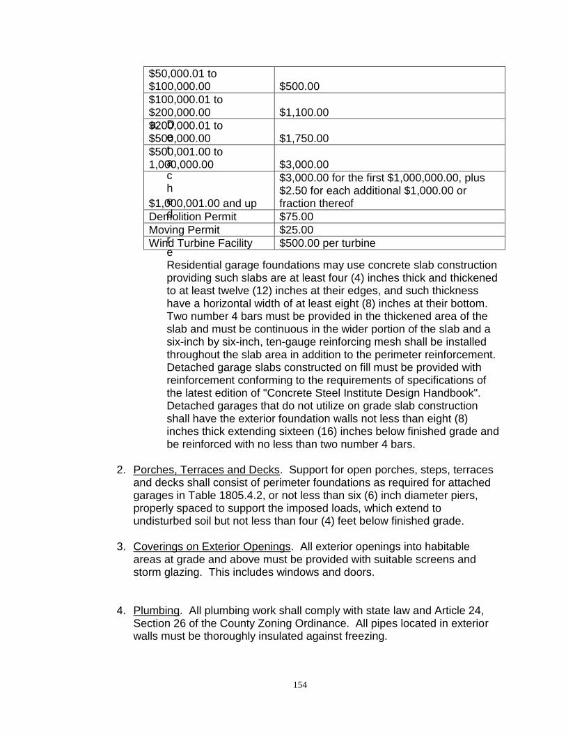
154
a. Detached reResidential garage foundations may use concrete slab construction providing such slabs are at least four (4) inches thick and thickened to at least twelve (12) inches at their edges, and such thickness have a horizontal width of at least eight (8) inches at their bottom. Two number 4 bars must be provided in the thickened area of the slab and must be continuous in the wider portion of the slab and a six-inch by six-inch, ten-gauge reinforcing mesh shall be installed throughout the slab area in addition to the perimeter reinforcement. Detached garage slabs constructed on fill must be provided with reinforcement conforming to the requirements of specifications of the latest edition of "Concrete Steel Institute Design Handbook". Detached garages that do not utilize on grade slab construction shall have the exterior foundation walls not less than eight (8) inches thick extending sixteen (16) inches below finished grade and be reinforced with no less than two number 4 bars.
2. Porches, Terraces and Decks. Support for open porches, steps, terraces
and decks shall consist of perimeter foundations as required for attached garages in Table 1805.4.2, or not less than six (6) inch diameter piers, properly spaced to support the imposed loads, which extend to undisturbed soil but not less than four (4) feet below finished grade.
3. Coverings on Exterior Openings. All exterior openings into habitable areas at grade and above must be provided with suitable screens and storm glazing. This includes windows and doors.
4. Plumbing. All plumbing work shall comply with state law and Article 24, Section 26 of the County Zoning Ordinance. All pipes located in exterior walls must be thoroughly insulated against freezing.
$50,000.01 to $100,000.00 $500.00
$100,000.01 to $200,000.00 $1,100.00
$200,000.01 to $500,000.00 $1,750.00
$500,001.00 to 1,000,000.00 $3,000.00
$1,000,001.00 and up
$3,000.00 for the first $1,000,000.00, plus $2.50 for each additional $1,000.00 or fraction thereof
Demolition Permit $75.00
Moving Permit $25.00
Wind Turbine Facility $500.00 per turbine
155
Section 9. Underground Utilities All new subdivision construction shall utilize underground utility and service lines whenever practical and possible. Exceptions to this rule shall include temporary services. Section 10. All Structures to Conform to Article 24 All residential, commercial, and industrial buildings and structures shall conform to Article 24 (Sanitation Requirements) of this Zoning Code of Ordinances.
156
ARTICLE 23.1 MECHANICAL CONSTRUCTION REQUIREMENTS Section 1. Adoption of the North Dakota State Building Code
1. There is hereby adopted by the County of Burleigh and incorporated by reference herein the North Dakota State Building Code including the appendices contained herein and except those portions hereinafter deleted, modified or amended by the Board of County Commissioners. There must be one copy on file with the County Building/Planning/Zoning Department.
2. The provisions of this code shall govern and apply to the design and
installation of all mechanical systems, including the erection, installation, alteration, repair, relocation, replacement, addition to, use or maintenance of any heating, ventilation, cooling, refrigeration systems, incinerators, or other miscellaneous heat-producing appliances and gas piping in any building or on any property within the jurisdictional limits of the County. Work on gas service lines from the supply main to the meter location performed by the utility franchise holder are excluded from the requirements of this article.
Section 2. Amendments to the Code The North Dakota State Building Code is hereby amended as follows:
1. Owner Responsibility. The owner shall be responsible for complying with the requirements for maintenance inspections of boilers and pressure vessels as noted in this section. Such inspections shall be conducted by a person knowledgeable in the installation, operation and maintenance of such boilers and pressure vessels. A report of all such inspections must be maintained and be made available to the Building Official upon request.
2. Prohibited Locations. Equipment burning liquid fuel shall not be located in a pit, an underfloor space, below grade or similar location where vapors or fuel might unsafely collect unless an approved method for the safe collection, removal and containment or disposal of the vapors or fuel is provided.
Section 3. Subsequent Editions
Subsequent editions or revisions of the code adopted by the provisions of this Article shall be considered adopted and of full force and effect within the county upon approval by the Board of County Commissioners and filing of one copy in
157
the office of the County Building/Planning/Zoning Department. Section 4. Conflicts In the event of any conflict between the provision of the North Dakota State Building Code or applicable provisions of State law and County resolutions, ordinances, rules or regulations, the provisions of County resolutions, ordinances, rules or regulations shall prevail and be controlling. Section 5. Qualifications and Licenses Unless otherwise provided by this article, all work performed on mechanical systems in buildings located within the County must meet State and Local standards for licensed contractors. Section 6. Insurance Every master heating and cooling contractor doing business within the County shall be a licensed contractor with the State of North Dakota. Section 7. Exception Notwithstanding any other provisions of this article, the owner-occupant of a single-family dwelling unit may perform work governed by this article, with the assistance of members of the owner-occupant's family or household, provided that a permit is obtained, if required by this article, from the Building Official. Section 8. Permits; Exceptions A work permit is required to do all heating and cooling work within the County covered by this Article, unless exempted by express language of this Article.
Section 9. Permit Application and Fees Applications for a permit must be made with the Building Official on forms provided and, if required, shall include plans, specifications and estimates of costs. When the provisions of this Article are fulfilled a permit must be issued by the Building Official. The permit is issued in accordance with the following schedule:
$1.00 to $2,000.00 $40.00
$2,001.00 to $20,000.00 $60.00
$20,001.00 to 100,000.00
$150.00
$150.00 for the first $100,000.00 plus $.60 for each
158
$100,001.00 and up additional $1,000.00, for each additional $1,000.00 or fraction thereof
Section 10. Transfer Prohibited A person or company holding a master heating and cooling contractor's license may not allow the use of its name, or any permit granted to them by any other person or company.
159
ARTICLE 24 SANITATION REQUIREMENTS PLUMBING IN GENERAL Section 1. Enforcement All plumbing work and all private sanitary drains, and cesspools, now existing, and hereafter to be installed, altered or repaired in any building or in or under any private property within the zoned area of the county, excluding farms and agricultural uses, shall be under the supervision and regulation of the Building Official, whose duty it shall be to enforce all the provisions of this chapter relating thereto and from time to time to make such rules and regulations as may be appropriate for the execution of the same. In case any difference should arise between the Building Official and the owner of any property subject to the regulations of this chapter, or any person engaged in or desirous of doing any plumbing or sewer work, regarding the interpretation of any of the provisions of this chapter or the enforcement of the same, appeal may be made to the Board of County Commissioners whose decision thereon shall be final. Section 2. Defective Work, Installation The Building Official is hereby given authority to order the repair, alteration or removal of any sanitary sewer connection or plumbing or any private sanitary drain, which in his judgment is so installed, or is in such condition as to be unsanitary, or to constitute a public nuisance or menace to health. In case such repair, alteration or removal of the plumbing is not observed and connections not properly executed by the owner or owners thereof, in accordance with the directions of the Building Official. It shall thereafter be unlawful for any person in any manner to use any such installation, or to supply water thereto, until the same shall have been put in safe and sanitary condition according to the directions of the Building Official. Section 3. Application to Certain Work All plumbing work and all excavations involving the laying of water and sewer connections, and all construction of private sanitary drains, within the zoned area of the County shall be undertaken and executed only by a master plumber, or other persons, as have obtained a general license for such work, together with a permit for each separate job; and provided further, that the Building Official may, at his discretion, issue permits for the construction of private sanitary drains to unlicensed persons who, in his judgment, are competent to do such work.
160
Sections 4 through 10 Reserved LICENSES Section 11. Licenses Required
No person shall engage in business as a master plumber or journeyman plumber without being licensed as a plumber in such classification by the State of North Dakota.
Sections 12 through 15 Reserved PERMITS Section 16. Permits Required Whenever any master plumber licensed by the state to engage in the work covered by this chapter, or homeowner shall desire to commence any such work, he shall first make application to the Office of the Building Official for a permit to execute the same.
Section 17. Permits – When Not Required No permit shall be required for ordinary repairs to plumbing.
Section 18. Issuance of Permits When, after due consideration and examination, it shall appear to the Building Official that the provisions of this chapter are complied with, he shall issue the permit requested.
Section 19. Permit Application and Fees Applications for a permit must be made with the Building/Planning/Zoning Department on forms provided, and if required shall include plans, specifications and estimates of the cost. When the provisions of this chapter have been met a permit must be issued by the Building/Planning/Zoning Department. For septic tanks and drainfields, a report from a Certified Soils Classifier or a Certified Soils Testing Agency, that indicates the soil types and specifications for an individual site and that the property is suitable for the location of a septic system on that site as per the current North Dakota Sewer and Water Service Code, is required prior to issuance of a permit. As an alternative, installation of three hundred and fifty (350) square feet of drainfield per bedroom, installed in accordance with the applicable requirements of the North Dakota Plumbing
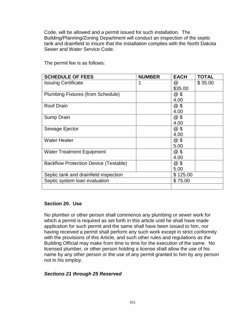
161
Code, will be allowed and a permit issued for such installation. The Building/Planning/Zoning Department will conduct an inspection of the septic tank and drainfield to insure that the installation complies with the North Dakota Sewer and Water Service Code.
The permit fee is as follows:
SCHEDULE OF FEES NUMBER EACH TOTAL
Issuing Certificate 1 @ $35.00
$ 35.00
Plumbing Fixtures (from Schedule) @ $ 4.00
Roof Drain @ $ 4.00
Sump Drain @ $ 4.00
Sewage Ejector @ $ 4.00
Water Heater @ $ 5.00
Water Treatment Equipment @ $ 4.00
Backflow Protection Device (Testable) @ $ 5.00
Septic tank and drainfield inspection $ 125.00
Septic system loan evaluation $ 75.00
Section 20. Use No plumber or other person shall commence any plumbing or sewer work for which a permit is required as set forth in this article until he shall have made application for such permit and the same shall have been issued to him, nor having received a permit shall perform any such work except in strict conformity with the provisions of this Article, and such other rules and regulations as the Building Official may make from time to time for the execution of the same. No licensed plumber, or other person holding a license shall allow the use of his name by any other person or the use of any permit granted to him by any person not in his employ.
Sections 21 through 25 Reserved
162
PLUMBING CODE Section 26. Adoption To promote and protect the public health there is hereby adopted the State Plumbing Code, 1988 Edition, as revised, which has been adopted by the State Plumbing Board and approved by the State Health Department.
Section 27. Subsequent Editions Subsequent editions or revisions of the code adopted by the provisions of this article shall be considered adopted and of full force and effect within the zoned area of the county upon the approval thereof by the County Commissioners and the filing of three (3) copies thereof in the office of the County Building/Planning/Zoning Department.
Section 28. Conflicts In the event of any conflict between the provisions of the code adopted by this Article and applicable provisions of this zoning ordinance, State law or County ordinances, rules or regulations, the provisions of this ordinance, State law or County ordinances, rules or regulations shall prevail and be controlling.
Section 29. Definitions Whenever the word "municipality" or the word "city" is used in the code adopted by this Article, it shall be construed to mean Burleigh County, North Dakota. Whenever the words "corporate counsel" or "city attorney" are used in the code adopted by this article, it shall be construed to mean the state’s attorney of this county. Section 30. Penalty for Violation Any person who shall violate any provision of the code adopted by the provisions of this Article shall be deemed guilty of a misdemeanor, and shall be punished as provided in Article 31 of the Burleigh County Zoning Ordinance. Each day such violation continues shall be deemed a separate offense.
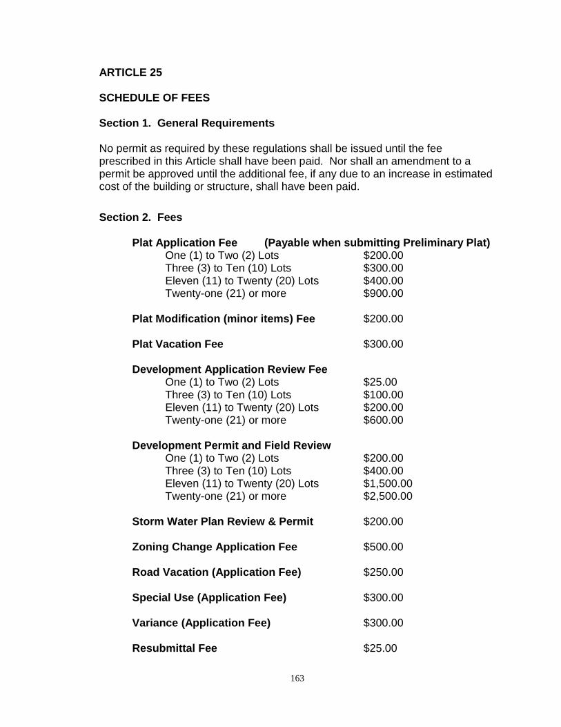
163
ARTICLE 25 SCHEDULE OF FEES Section 1. General Requirements No permit as required by these regulations shall be issued until the fee prescribed in this Article shall have been paid. Nor shall an amendment to a permit be approved until the additional fee, if any due to an increase in estimated cost of the building or structure, shall have been paid.
Section 2. Fees
Plat Application Fee (Payable when submitting Preliminary Plat) One (1) to Two (2) Lots $200.00 Three (3) to Ten (10) Lots $300.00 Eleven (11) to Twenty (20) Lots $400.00 Twenty-one (21) or more $900.00
Plat Modification (minor items) Fee $200.00 Plat Vacation Fee $300.00 Development Application Review Fee
One (1) to Two (2) Lots $25.00 Three (3) to Ten (10) Lots $100.00 Eleven (11) to Twenty (20) Lots $200.00 Twenty-one (21) or more $600.00
Development Permit and Field Review
One (1) to Two (2) Lots $200.00 Three (3) to Ten (10) Lots $400.00 Eleven (11) to Twenty (20) Lots $1,500.00 Twenty-one (21) or more $2,500.00
Storm Water Plan Review & Permit $200.00 Zoning Change Application Fee $500.00 Road Vacation (Application Fee) $250.00 Special Use (Application Fee) $300.00 Variance (Application Fee) $300.00 Resubmittal Fee $25.00
164
Section 3. Other Fees All fees required under this Article are in addition to any fee for licenses or any other fees or charges required under other regulations.
Section 4. Crediting of Fees Collected All fees collected under provisions of this Article shall be credited to the General Fund of the County.
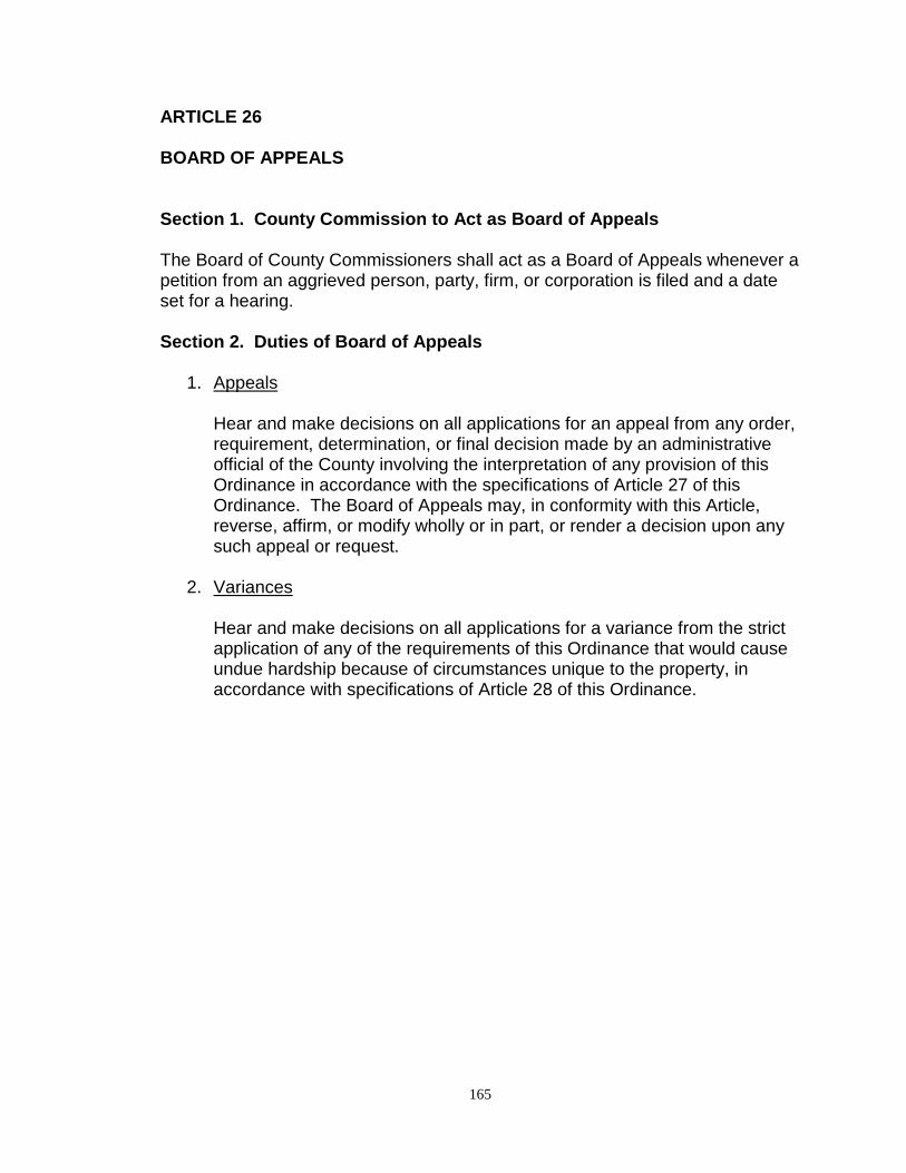
165
ARTICLE 26 BOARD OF APPEALS Section 1. County Commission to Act as Board of Appeals The Board of County Commissioners shall act as a Board of Appeals whenever a petition from an aggrieved person, party, firm, or corporation is filed and a date set for a hearing. Section 2. Duties of Board of Appeals
1. Appeals Hear and make decisions on all applications for an appeal from any order,
requirement, determination, or final decision made by an administrative official of the County involving the interpretation of any provision of this Ordinance in accordance with the specifications of Article 27 of this Ordinance. The Board of Appeals may, in conformity with this Article, reverse, affirm, or modify wholly or in part, or render a decision upon any such appeal or request.
2. Variances Hear and make decisions on all applications for a variance from the strict
application of any of the requirements of this Ordinance that would cause undue hardship because of circumstances unique to the property, in accordance with specifications of Article 28 of this Ordinance.
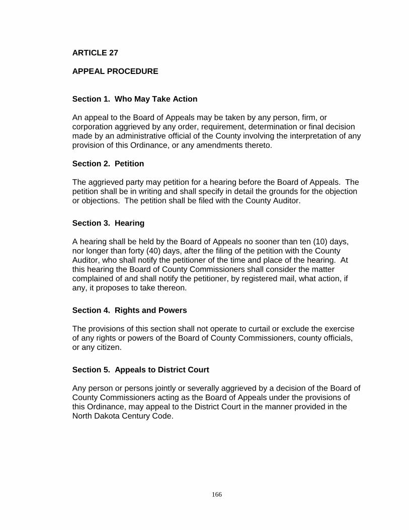
166
ARTICLE 27 APPEAL PROCEDURE Section 1. Who May Take Action An appeal to the Board of Appeals may be taken by any person, firm, or corporation aggrieved by any order, requirement, determination or final decision made by an administrative official of the County involving the interpretation of any provision of this Ordinance, or any amendments thereto. Section 2. Petition The aggrieved party may petition for a hearing before the Board of Appeals. The petition shall be in writing and shall specify in detail the grounds for the objection or objections. The petition shall be filed with the County Auditor.
Section 3. Hearing A hearing shall be held by the Board of Appeals no sooner than ten (10) days, nor longer than forty (40) days, after the filing of the petition with the County Auditor, who shall notify the petitioner of the time and place of the hearing. At this hearing the Board of County Commissioners shall consider the matter complained of and shall notify the petitioner, by registered mail, what action, if any, it proposes to take thereon.
Section 4. Rights and Powers The provisions of this section shall not operate to curtail or exclude the exercise of any rights or powers of the Board of County Commissioners, county officials, or any citizen.
Section 5. Appeals to District Court Any person or persons jointly or severally aggrieved by a decision of the Board of County Commissioners acting as the Board of Appeals under the provisions of this Ordinance, may appeal to the District Court in the manner provided in the North Dakota Century Code.
167
ARTICLE 28 VARIANCES
Section 1. Who May Take Action
An application for a variance may be made by any person, firm, or corporation with a legal interest in the property for which the variance is being sought. Applications shall be submitted to the Planning and Zoning Department at least twenty-one (21) days prior to a meeting of the County Planning and Zoning Commission. Section 2. Hearing
Following submission of a variance application, the Planning and Zoning Department shall set a time and place for a public hearing before the Planning and Zoning Commission. Notice of the time and place of such public hearing shall be published in a newspaper of general circulation in the County of Burleigh once each week for two (2) consecutive weeks prior to the date of the hearing. Not less than ten (10) days prior to the scheduled public hearing, all known adjacent property owners within 1,320 feet shall be notified by letter of the hearing. Following the public hearing, the Planning and Zoning Department shall forward the request to the Board of County Commissioners (sitting as the Board of Appeals) together with the Planning and Zoning Commission’s recommendation and a report fully setting forth the reasons for such recommendation. Section 3. Required Findings The Board of County Commissioners may vary or adjust the strict application of any of the requirements of this Ordinance in the case of an exceptionally irregular, narrow, shallow, or steep lot, or other exceptional physical or topographical condition, by reason of which the strict application of the provisions of the Ordinance would result in unnecessary hardship that would deprive the owner of a reasonable use of the land or building involved. It is not the intent of this article to allow a variance for a land use that is not permitted within the particular zoning district.
No adjustment in the strict application of any provisions of this Ordinance shall be granted by the Board of County Commissioners unless it finds:
1. That there are special circumstances or conditions, fully described in the findings of the Board, applying to the land or buildings for which the variance is sought, which circumstances or conditions are peculiar to such
168
land or building, and do not apply generally to land or buildings in the neighborhood, and have not resulted from any act of the applicant taken subsequent to the adoption of this article, whether in violation of the provisions of the Ordinance, or not.
2. That, for reasons fully set forth in the findings of the Board, the
circumstances or conditions so found are such that the strict application of the provisions of this Ordinance would deprive the applicant of the reasonable use of said land or building, and the granting of the variances necessary for the reasonable use of the land or building and that the variance as granted by the Board is the minimum variance that would accomplish the relief sought by the applicant.
3. That the grant of the variance will be in harmony with the general
purposes and intent of this Ordinance and will not be injurious to the neighborhood or otherwise detrimental to the public welfare.
4. In no case shall any variance be more than a minimum easing of the
requirements; in no case shall it have the effect of reducing the traffic capacity of any major or secondary street; in no case shall it be in conflict with existing zoning regulations.
5. In granting variances, the Board of County Commissioners may require
such conditions as will, in its judgment, secure substantially the objectives of the standards and regulations so affected.
6. A variance granted under this article must be put into use within twenty-
four (24) months of the granting of the variance or it shall lapse and the land owner must reapply.
169
ARTICLE 29 AMENDMENTS Section 1. Purpose Whenever the public necessity, convenience, general welfare, or good zoning practice requires, the Board of County Commissioners may amend, supplement, or change the regulations in the Zoning Ordinance, or the zoning boundaries or classification of property on the zoning map, as set forth herein. Section 2. Initiation of Amendments Amendments to the Zoning Ordinance shall be initiated only in the following manner:
1. Amendments to the text of the Ordinance and/or changes in the zoning boundaries or classification of properties shown on the zoning map may be initiated by the Board of County Commissioners, the Planning and Zoning Commission, or the Building/Planning/Zoning Department.
2. Amendments to the zoning boundaries or classification of property shown
on the zoning map may be initiated by property owners of the land proposed to be re-zoned, by the filing with the Planning Department of a zoning change application, which application shall be provided by the Planning Department, and accompanied by the required fee and all other materials and data required in said application.
Section 3. Application for Amendment The zoning change application shall be completed and filed by one or more of the owners of the property proposed to be changed, or his/her designated agent. The zoning change application shall contain the following information:
a. Name of applicant b. Mailing address and e-mail address c. Telephone number d. Accurate legal description of location e. Nature of zoning change requested f. Description of present land uses g. Description of adjacent land uses h. Statement of intended land use i. Statement concerning any expected effect upon adjacent
neighborhood j. Names and addresses of adjacent property owners k. Signature of applicant
170
Section 4. Application Submission The zoning change application shall be submitted at least twenty-one (21) days prior to a Planning and Zoning Commission meeting and shall not be accepted by the Planning Department until all Ordinance requirements for the application have been met. Section 5. Preliminary Consideration by the Planning Commission The Planning Department, upon the satisfactory fulfillment of the zoning change application and requirements contained herein, shall schedule the requested amendment for a meeting of the Planning and Zoning Commission. The Planning and Zoning Commission may approve and call for a public hearing on the request, deny the request, or postpone to a certain time the request for further consideration and study. Section 6. Public Hearing by the Planning and Zoning Commission Following preliminary approval of a zoning change application, the Planning Department shall set a time and place for a public hearing hereon. Not less than two (2) weeks’ notice of the time and place of holding such public hearing shall first be published in a newspaper of general circulation in the County of Burleigh. Not less than ten (10) days prior to the scheduled public hearing all known adjacent property owners within 1,320 feet shall be notified by letter of the hearing. The Planning and Zoning Commission may approve, approve subject to certain stated conditions being met, continue, deny, or postpone to a certain time the application for further consideration and study. Section 7. Planning and Zoning Commission Recommendation Following the public hearing, the Planning Department shall forward the proposed amendment to the Board of County Commissioners together with the Planning Commission's recommendation and a report fully setting forth the reasons for such recommendation. Section 8. Board of County Commissioners Action Upon receipt of the Planning and Zoning Commission's recommendation and report, the Board of County Commissioners shall consider the proposed amendment and shall take final action on the zoning change request after examination of the Planning and Zoning Commission procedures. Section 9. Withdraw of Applications Any application filed pursuant to subsection 2 of Section 2 above may be
171
withdrawn upon written request by the applicant any time prior to the submission of any public hearing notice for advertisement; provided, that the request for withdrawal shall be honored only with the consent of either the Planning and Zoning Commission or the Board of County Commissioners, whichever body has advertised the hearing. Section 10. Administrative Amendments The Planning and Zoning Commission may from time to time adopt and amend rules and instructions for the administration of these regulations. Administrative amendments approved by the Planning and Zoning Commission are subject to the approval of the Board of County Commissioners.
172
ARTICLE 30 ENFORCEMENT AND ADMINISTRATIVE LIABILITY Section 1 Enforcement
In accordance with the provisions of Section 11-36-16 of the North Dakota
Century Code, which provides for the enforcement of County Zoning Ordinances
by any officer, department, agency or employee designated to perform such
duties by the Board of County Commissioners, the County Auditor, Building
Official, Planning Director and their departmental employees, have been
delegated the duty of enforcing the 1972 Amended Zoning Ordinance of Burleigh
County.
Section 2. Administrative Liability
No officer, agent or employee of the County of Burleigh shall render himself
personally liable for any damage that may accrue to persons or property as a
result of any act required or permitted in the discharge of his duties under this
Ordinance. Any suit brought against any officer, agent or employee of the County
of Burleigh as a result of any act required or permitted in the discharge of his
duties under this Ordinance shall be defended by the State's Attorney until the
final determination of the proceedings therein.
Section 3. Accumulation of Certain Items Prohibited.
1. No person shall cause, permit, keep, accumulate or allow the
accumulation of any, junk, refuse, surplus, scrap, salvage or other similar
items outside of a closed building in any zoned district. The items for
which accumulations are prohibited under this section may include one or
more of the following but are not limited to hazardous wastes, scrap
metals, used or scrap lumber, household appliances, machinery,
construction or demolition waste or salvage, abandoned or unlicensed
vehicle(s), automotive or machinery parts, tires, used oil or solvents,
garbage or rubbish of any kind, waste paper, used furniture or other
household goods, barrels, rags, boxes, cardboard, or other similar items.
The fact that an item or items has value or is operational shall not excuse
conduct prohibited by this section.
2. This Ordinance shall provide for the vacation, removal, repair or
demolition of any building or structure which is, or threatens to be, a public
nuisance, dangerous to the health, sanitation, safety or general welfare of
173
the people of the County of Burleigh, or which might tend to constitute a
fire menace; and for the assessment of the cost of vacation, removal,
repair or demolition thereof as a county lien or assessment against such
premises, and to provide for the recovery of such costs in an action at law.
Section 4. Violations, Penalty for Disregarding 1. It shall be unlawful for the owner to fail to comply with any Notice and Order to repair, vacate, demolish, or remove said building, structure, or accumulation of prohibited items, given by any person authorized by this Ordinance to give such Notice and Order and every day subsequent to such notice in which said owner shall fail to comply with a Notice and Order as above stated shall be deemed a separate offense. 2. It shall be unlawful for the occupant or lessee in possession to fail to comply with a Notice and Order to vacate or fail to comply in accordance with any Notice and Order given as provided for herein, and every day subsequent to such notice in which the said occupant or lessee shall fail to comply with Notice and Order as above stated shall be deemed a separate offense. 3. Violations of this Ordinance shall be punished in accordance with North Dakota Century Code Section 11-33-21 General penalties for violation of zoning regulations and restrictions. A violation of any provision of this chapter or the regulations and restrictions made there under shall constitute the maintenance of a public nuisance and shall be a Class B Misdemeanor.
174
ARTICLE 31
PENALTIES FOR VIOLATION Section 1. Complaints Regarding Violations Whenever a violation of this Ordinance occurs, or is alleged to have occurred, any person may file a written complaint concerning same. Such complaint shall state fully the causes and basis thereof and be filed with the Planning Department. The Department shall record such complaint, investigate same, and take action thereon as provided by this Ordinance. Complaints regarding violations are to be submitted to the States Attorney for prosecution when necessary. Section 2. Penalties for Violation In accordance with Section 11-33-21 of the North Dakota Century Code a violation of any provision of this Ordinance shall constitute the maintenance of a public nuisance and upon conviction there shall be a penalty of a fine of not more than Fifteen hundred (1,500) dollars, or imprisonment in a county jail for not more than thirty (30) days, or by both such fine and imprisonment.
175
ARTICLE 32 SEVERABILITY, REPEAL, EFFECTIVE DATE Section 1. Severability If any section, sub-sentence, clause, or phrase of this regulation is for any reason held to be invalid or unconstitutional by the decision of any court of competent jurisdiction, such decision shall not affect the validity of the remaining portions of the regulation. The Board of County Commissioners hereby declares that it would have passed this regulation and each section, subsection, sentence, clause, and phrase thereof, irrespective of the fact that any one or more sections, subsections, sentences, clauses, or phrases may be declared invalid or unconstitutional. Section 2. Repeal All regulations or parts of regulations, in conflict with this Ordinance are hereby repealed. Section 3. Effective Date This Ordinance shall become effective immediately upon adoption by the Board of County Commissioners and publication of same in accordance with state law. The adoption of this amended and revised Ordinance shall in no way effect actions taken under the 1959 and 1963 editions of the Burleigh County Zoning Regulations.
176
ARTICLE 33 SUBDIVISION REGULATIONS The following regulations apply to the subdivision of any and all land within Burleigh County that is not within the corporate limits or within the area of application of extraterritorial jurisdiction of any city. Section 1. Purpose of Subdivision Regulations In order to provide for the proper arrangement of streets in relation to other existing and planned streets, and to the master plan of Burleigh County; to provide for adequate and convenient open spaces; for recreation; for light and air; in order to avoid congestion of population; in order to provide for traffic, utilities, for access of firefighting apparatus; in order to provide for, and improve, the public health, safety, and general welfare of the citizens of Burleigh County, the following rules and regulations have been adopted by the Planning Commission of Burleigh County in accordance with the laws of the State of North Dakota. Section 2. Planning and Zoning Commission Review The Planning and Zoning Commission of Burleigh County shall review and approve or disapprove the subdivision of all lands within its jurisdiction and recommend the same to the Board of County Commissioners. Section 3. Township Review For subdivisions proposed in areas not under the zoning jurisdiction of Burleigh County, the Township Board of Supervisors of the township in which the subdivision is located shall review the subdivision and make a recommendation to the Board of County Commissioners. Section 4. Definitions The following definitions represent the meanings of terms as they are used in these regulations: Alley - A strip of land, dedicated to public use, primarily to provide vehicular service access to the side or rear of properties otherwise abutting on a street. Easement - A grant by the property owner of the use of a strip of land by the public, or by one or more persons or corporations for a specific purpose or purposes.
177
Highway – Primary - Any Designated Interstate or Federal Route, such as I-94 or US 83. Primary highways provide for rapid movements of relatively large traffic volumes between large lane areas, major traffic generators and other arterials. Primary highways should have controlled access and are usually multi-land roads with no parking. Highway – Secondary - Any Designated State or County arterial route, such as Highway 1804 or County Highway 10. Secondary highways provide through traffic movements between Areas and links collectors with other arterials. Secondary highways usually have two to four lanes and may be divided or undivided roads, preferably with little or no parking, and limited access. Improvements - Street grading and surfacing, with or without curbs and gutter, sidewalks, crosswalks, water mains, sanitary and storm sewers, culverts, bridges, street trees. Lot - A portion of a subdivision, or other parcel of land intended as a unit for transfer of ownership or for development. Master Plan - The comprehensive plan, or any portion thereof, made and adopted by the Planning Commission in accordance with the laws of the State of North Dakota, indicating the general or specific locations recommended for streets, parks, public buildings, zoning districts and all other public improvements. Planning and Zoning Commission - The Planning and Zoning Commission of Burleigh County. Road – Collector - Roadway which provides traffic movements between local roads and arterial roads and highways and also provides direct access to abutting property. Collector roads are usually two-lane roads that should be designed to minimize on-street parking and direct driveway access. Road – Local - Roadway whose primary function is to provide access to abutting property. Local roads are usually two-lane roads with parking and direct access to adjacent lands. Subdivisions - The division of a lot, tract or parcel of land into lots for the purpose, whether immediate or future, of sales or building development, including any plat or plan which includes the creation of any part of one or more streets, public easements, or other rights-of-way, whether public or private, for access to or from such lots, and/or including the creation of new or enlarged parks, playgrounds, plazas or open spaces. "Subdivision" includes the re-subdivision of one or more lots in a subdivision made and recorded prior to or after the date these regulations are adopted. However, the division of land for
178
agricultural purposes into parcels of forty (40) or more acres, not involving any new street or easement of access, shall be exempted from these regulations. Section 5. Procedures The following procedures shall be followed in the process of platting except for the requirements found under Section 12 defined as Minor Changes to Existing Plats.
1. Preliminary Steps
a. The applicant shall determine the zoning district in which the property is located. If the zoning is not appropriate, the applicant will also need to request a zoning change. Proper zoning must be approved by the Board of County Commissioners before a subdivision proposal can be approved and filed.
1. For subdivisions proposed in areas not under the zoning jurisdiction of Burleigh County, documentation that the subdivision complies with the zoning requirements of the township must be provided along with the request for tentative approval of a preliminary plat.
b. Before preparing plans for a subdivision, the sub divider shall
consult informally with County planning and engineering officials concerning the relation of the property to existing conditions of zoning and need, future plans, community facilities, utilities, and other necessary services.
c. It is the duty of the Planning and Zoning Commission to discourage
the subdividing of lands that are far in advance of the needs of the community; or that by their location cannot be efficiently served by public utilities, fire protection, police protection or other services; or that are located in areas subject to flooding, or that are topographically unsuitable for development; or that for any other reason are being unwisely or prematurely subdivided.
2. Tentative Approval
a. The sub divider shall apply in writing on the required form to the
Planning Department for tentative approval of a subdivision plat at least twenty-one (21) days prior to the meeting of the Planning and Zoning Commission at which it is to be considered.
b. The number of prints of the preliminary plat of the subdivision as indicated in the current application form shall be filed with the
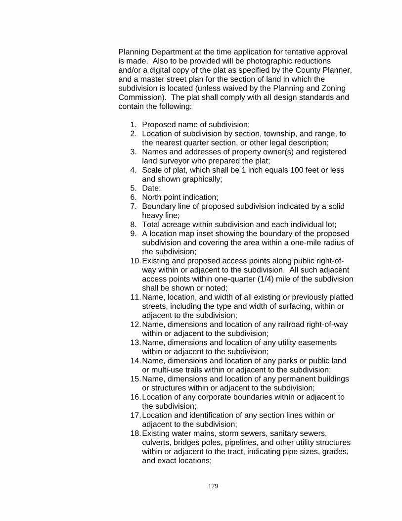
179
Planning Department at the time application for tentative approval is made. Also to be provided will be photographic reductions and/or a digital copy of the plat as specified by the County Planner, and a master street plan for the section of land in which the subdivision is located (unless waived by the Planning and Zoning Commission). The plat shall comply with all design standards and contain the following:
1. Proposed name of subdivision; 2. Location of subdivision by section, township, and range, to
the nearest quarter section, or other legal description; 3. Names and addresses of property owner(s) and registered
land surveyor who prepared the plat; 4. Scale of plat, which shall be 1 inch equals 100 feet or less
and shown graphically; 5. Date; 6. North point indication; 7. Boundary line of proposed subdivision indicated by a solid
heavy line; 8. Total acreage within subdivision and each individual lot; 9. A location map inset showing the boundary of the proposed
subdivision and covering the area within a one-mile radius of the subdivision;
10. Existing and proposed access points along public right-of-way within or adjacent to the subdivision. All such adjacent access points within one-quarter (1/4) mile of the subdivision shall be shown or noted;
11. Name, location, and width of all existing or previously platted streets, including the type and width of surfacing, within or adjacent to the subdivision;
12. Name, dimensions and location of any railroad right-of-way within or adjacent to the subdivision;
13. Name, dimensions and location of any utility easements within or adjacent to the subdivision;
14. Name, dimensions and location of any parks or public land or multi-use trails within or adjacent to the subdivision;
15. Name, dimensions and location of any permanent buildings or structures within or adjacent to the subdivision;
16. Location of any corporate boundaries within or adjacent to the subdivision;
17. Location and identification of any section lines within or adjacent to the subdivision;
18. Existing water mains, storm sewers, sanitary sewers, culverts, bridges poles, pipelines, and other utility structures within or adjacent to the tract, indicating pipe sizes, grades, and exact locations;
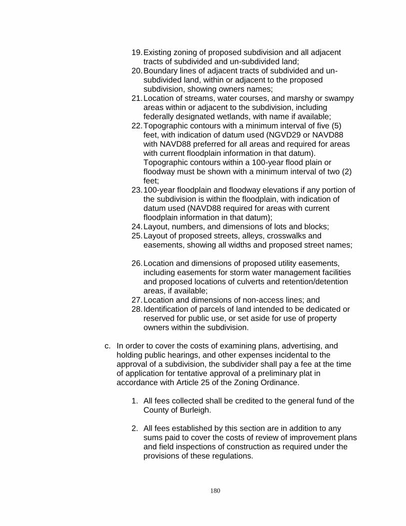
180
19. Existing zoning of proposed subdivision and all adjacent tracts of subdivided and un-subdivided land;
20. Boundary lines of adjacent tracts of subdivided and un-subdivided land, within or adjacent to the proposed subdivision, showing owners names;
21. Location of streams, water courses, and marshy or swampy areas within or adjacent to the subdivision, including federally designated wetlands, with name if available;
22. Topographic contours with a minimum interval of five (5) feet, with indication of datum used (NGVD29 or NAVD88 with NAVD88 preferred for all areas and required for areas with current floodplain information in that datum). Topographic contours within a 100-year flood plain or floodway must be shown with a minimum interval of two (2) feet;
23. 100-year floodplain and floodway elevations if any portion of the subdivision is within the floodplain, with indication of datum used (NAVD88 required for areas with current floodplain information in that datum);
24. Layout, numbers, and dimensions of lots and blocks; 25. Layout of proposed streets, alleys, crosswalks and
easements, showing all widths and proposed street names;
26. Location and dimensions of proposed utility easements, including easements for storm water management facilities and proposed locations of culverts and retention/detention areas, if available;
27. Location and dimensions of non-access lines; and 28. Identification of parcels of land intended to be dedicated or
reserved for public use, or set aside for use of property owners within the subdivision.
c. In order to cover the costs of examining plans, advertising, and
holding public hearings, and other expenses incidental to the approval of a subdivision, the subdivider shall pay a fee at the time of application for tentative approval of a preliminary plat in accordance with Article 25 of the Zoning Ordinance.
1. All fees collected shall be credited to the general fund of the
County of Burleigh. 2. All fees established by this section are in addition to any
sums paid to cover the costs of review of improvement plans and field inspections of construction as required under the provisions of these regulations.
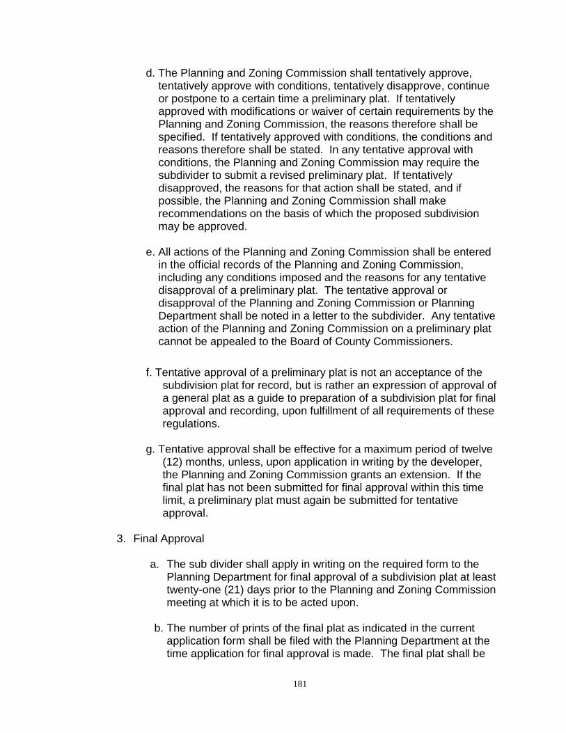
181
d. The Planning and Zoning Commission shall tentatively approve, tentatively approve with conditions, tentatively disapprove, continue or postpone to a certain time a preliminary plat. If tentatively approved with modifications or waiver of certain requirements by the Planning and Zoning Commission, the reasons therefore shall be specified. If tentatively approved with conditions, the conditions and reasons therefore shall be stated. In any tentative approval with conditions, the Planning and Zoning Commission may require the subdivider to submit a revised preliminary plat. If tentatively disapproved, the reasons for that action shall be stated, and if possible, the Planning and Zoning Commission shall make recommendations on the basis of which the proposed subdivision may be approved.
e. All actions of the Planning and Zoning Commission shall be entered
in the official records of the Planning and Zoning Commission, including any conditions imposed and the reasons for any tentative disapproval of a preliminary plat. The tentative approval or disapproval of the Planning and Zoning Commission or Planning Department shall be noted in a letter to the subdivider. Any tentative action of the Planning and Zoning Commission on a preliminary plat cannot be appealed to the Board of County Commissioners.
f. Tentative approval of a preliminary plat is not an acceptance of the subdivision plat for record, but is rather an expression of approval of a general plat as a guide to preparation of a subdivision plat for final approval and recording, upon fulfillment of all requirements of these regulations.
g. Tentative approval shall be effective for a maximum period of twelve
(12) months, unless, upon application in writing by the developer, the Planning and Zoning Commission grants an extension. If the final plat has not been submitted for final approval within this time limit, a preliminary plat must again be submitted for tentative approval.
3. Final Approval
a. The sub divider shall apply in writing on the required form to the
Planning Department for final approval of a subdivision plat at least twenty-one (21) days prior to the Planning and Zoning Commission meeting at which it is to be acted upon.
b. The number of prints of the final plat as indicated in the current application form shall be filed with the Planning Department at the time application for final approval is made. The final plat shall be
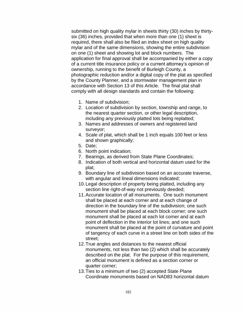
182
submitted on high quality mylar in sheets thirty (30) inches by thirty-six (36) inches, provided that when more than one (1) sheet is required, there shall also be filed an index sheet on high quality mylar and of the same dimensions, showing the entire subdivision on one (1) sheet and showing lot and block numbers. The application for final approval shall be accompanied by either a copy of a current title insurance policy or a current attorney’s opinion of ownership, running to the benefit of Burleigh County, a photographic reduction and/or a digital copy of the plat as specified by the County Planner, and a stormwater management plan in accordance with Section 13 of this Article. The final plat shall comply with all design standards and contain the following:
1. Name of subdivision; 2. Location of subdivision by section, township and range, to
the nearest quarter section, or other legal description, including any previously platted lots being replatted;
3. Names and addresses of owners and registered land surveyor;
4. Scale of plat, which shall be 1 inch equals 100 feet or less and shown graphically;
5. Date; 6. North point indication; 7. Bearings, as derived from State Plane Coordinates; 8. Indication of both vertical and horizontal datum used for the
plat; 9. Boundary line of subdivision based on an accurate traverse,
with angular and lineal dimensions indicated; 10. Legal description of property being platted, including any
section line right-of-way not previously deeded; 11. Accurate location of all monuments. One such monument
shall be placed at each corner and at each change of direction in the boundary line of the subdivision; one such monument shall be placed at each block corner; one such monument shall be placed at each lot corner and at each point of deflection in the interior lot lines; and one such monument shall be placed at the point of curvature and point of tangency of each curve in a street line on both sides of the street;
12. True angles and distances to the nearest official monuments, not less than two (2) which shall be accurately described on the plat. For the purpose of this requirement, an official monument is defined as a section corner or quarter corner;
13. Ties to a minimum of two (2) accepted State Plane Coordinate monuments based on NAD83 horizontal datum
183
(adjusted 86), units of measurement international feet, ND south zone 3302;
14. Elevations referenced to a durable benchmark described on the plat with its location and elevation to the nearest hundredth of a foot, with indication of datum used (NAVD88 preferred for all plats and required for areas with current floodplain information in that datum);
15. Exact location, width and name of all rights-of-way within and adjoining the subdivision, and the exact location of all alleys or multi-use trails within the subdivision;
16. Accurate outlines and legal descriptions of any areas (not including streets, alleys or public utility easements) to be dedicated or reserved for public use, with purposes indicated; and of any areas to be reserved by deed covenant for common use of all property owners within the subdivision;
17. All easements for the rights-of-way provided for public services and public utilities, including the location of all storm water management facilities identified in the storm water management plan;
18. All lot and block numbers and lot lines, with accurate dimensions in feet and hundredths;
19. Square footage or acreage of land within the subdivision, each individual lot and the total area in streets. If the subdivision crosses a quarter-section line, the acreage within each quarter section must also be noted;
20. Radii, deltas and lengths of all curves based on arc definitions;
21. Location and dimension of non-access lines and any access points within a continuous non-access line;
22. 100-year floodplain and floodway elevations and topographic contours with a minimum contour interval of two (2) feet for the portion of the plat lying within a designated floodplain, with indication of datum used (NAVD88 preferred for all plats and required for areas with current floodplain information in that datum);
23. For any waterways or bodies of water within or immediately adjacent to the plat, the present shoreline locations (relative to meander line);
24. Water elevations must be shown and dated (meander line); 25. For subdivisions adjacent to the Missouri River, the 33,000
cfs flowline contour must be shown, which is the ordinary high water mark defined herein for the purpose of measuring setback distances for land abutting the Missouri River;
26. Certification by registered land surveyor to the effect that the plat represents a survey made by him/her, or under the

184
surveyor’s direct supervision, and that the monuments shown thereon exist as located, all required monuments have been set, and that all dimensions and elevations are correct;
27. Notarized certification by the owner(s) of the land of the adoption of the plat and the dedication of sewers, water distribution lines, streets, public areas and other improvements. If there are multiple owners, the specific lot(s) owned by each must be specified;
28. Proper form for approval of or review by the Planning Commission;
29. Proper form for acceptance of plat, and amendment of Master Street Plan by the Board of County Commissioners; and
30. Proper form for approval of the County Engineer.
c. At the time of submission of the application for final approval, assurance of completion of the required improvements (in a form acceptable to the Planning and Zoning Commission) is required. At this time the County Engineer shall approve, modify, or disapprove proposed culvert sizes and locations as shown on the preliminary plat.
d. After receipt of all items required for the application for final approval, the Planning Department shall give notice of a public hearing on the proposed subdivision by advertising the time and place of the hearing in the official newspaper of Burleigh County once a week for two (2) consecutive weeks prior to the date of such hearing. Not less than ten (10) days prior to the date of such hearing, all known adjacent property owners within 1,320 feet of the proposed subdivision shall be notified of the public hearing by letter.
e. After the public hearing, the Planning and Zoning Commission will
act upon the request for final approval. If the Planning and Zoning Commission approves the subdivision, such approval will be entered upon the tracing and will be signed by the Secretary and the Chairman of the Planning Commission. If the Planning Commission disapproves the subdivision, such action, together with the reasons therefore will be entered in the official records of the Planning and Zoning Commission and a copy of such record will be sent to the sub divider.
f. Final approval of a subdivision by the Planning and Zoning Commission shall in no way constitute legal acceptance of any dedicated streets, alleys or other public lands.
185
g. A final plat that is approved by the Planning and Zoning
Commission will be recommended for approval to the Board of County Commissioners. A final plat that is denied by the Planning and Zoning Commission will not be forwarded to the Board of County Commissioners; however, the sub divider has the right to appeal the decision of the Planning and Zoning Commission to the Board of County Commissioners in accordance with Section 7, Article 2.
h. Before the construction of the roadways can take place the sub
divider shall submit a Development Permit Application for review and approval by the Planning Department. The application shall comply with all design standards and contain the following:
1. Grading plan for site, including the following; 2. Vicinity map 3. Basis of survey 4. Certification of registered professional engineer 5. Typical cross-section for all roadway sections 6. Estimated Quantities 7. Plan view of project 8. Grading Profile sheets 9. Erosion Control plan 10. Drainage plan 11. Culvert table: Including size, type, location and invert
elevations 12. Paving plan 13. All digital design files in DWG format 14. Copy of the Storm Water Management Plan 15. Other items (unique to the subdivision) as requested by the
County Engineer
i. Final plats will not be recorded with the Burleigh County Recorder until all proceeding steps are completed and the roads are constructed to meet County Standards and are accepted by the County Engineer.
j. Following final approval by the Board of County Commissioners, a plat in recordable form shall be furnished to the County Planner within one hundred eighty (180) days. Extensions of thirty (30) days may be granted by the County Planner for good cause shown in writing. Upon review and obtaining required signatures, the final plat shall be returned to the sub divider for making copies and recording. The sub divider shall file and record the original signed
186
final plat with the Burleigh County Recorder within thirty (30) days of receiving the signed final plat. Failure to file the signed original of the approved final plat within said thirty (30) days shall constitute voidance of approval of the final plat, with reinstatement only possible by final plat re-consideration by the Planning Commission. Extensions of thirty (30) days may be granted by the County Planner for good cause shown in writing. All final plats shall also be provided digitally formatted to Burleigh County’s current computer aided drafting and geographic system software and policy, including coordinate system ties as defined within this zoning ordinance.
k. A reproducible mylar copy and six (6) prints of the signed final plat
are to be filed with the Planning Department.
Section 6. Design Standards
1. Streets and Roads
a. The arrangement, character, extent, width, grade, and location of all streets shall conform to the County Highway Department Standards and the current Master Plan and shall be considered in relation to existing and planned streets, to topographical conditions, and to the proposed uses of lands to be served.
b. Where it is now shown on the Master Plan, the arrangement of streets in a subdivision shall either:
1. Provide for the continuation, or appropriate projection, of
existing principal streets in surrounding areas; or 2. Conform to a plan for the neighborhood approved or adopted
by the Planning Commission to meet a particular situation where topographical or other conditions make continuance of or conformance to existing streets impractical.
c. Minor streets shall be so laid out that their use by through traffic is
discouraged.
d. Where a subdivision abuts or contains an existing or proposed major street, the Planning Commission may, at its discretion, require marginal access streets, reverse frontage of lots with a screen planting contained in a no-access reservation along the rear property lines, deep lots with rear service alleys, or other treatment
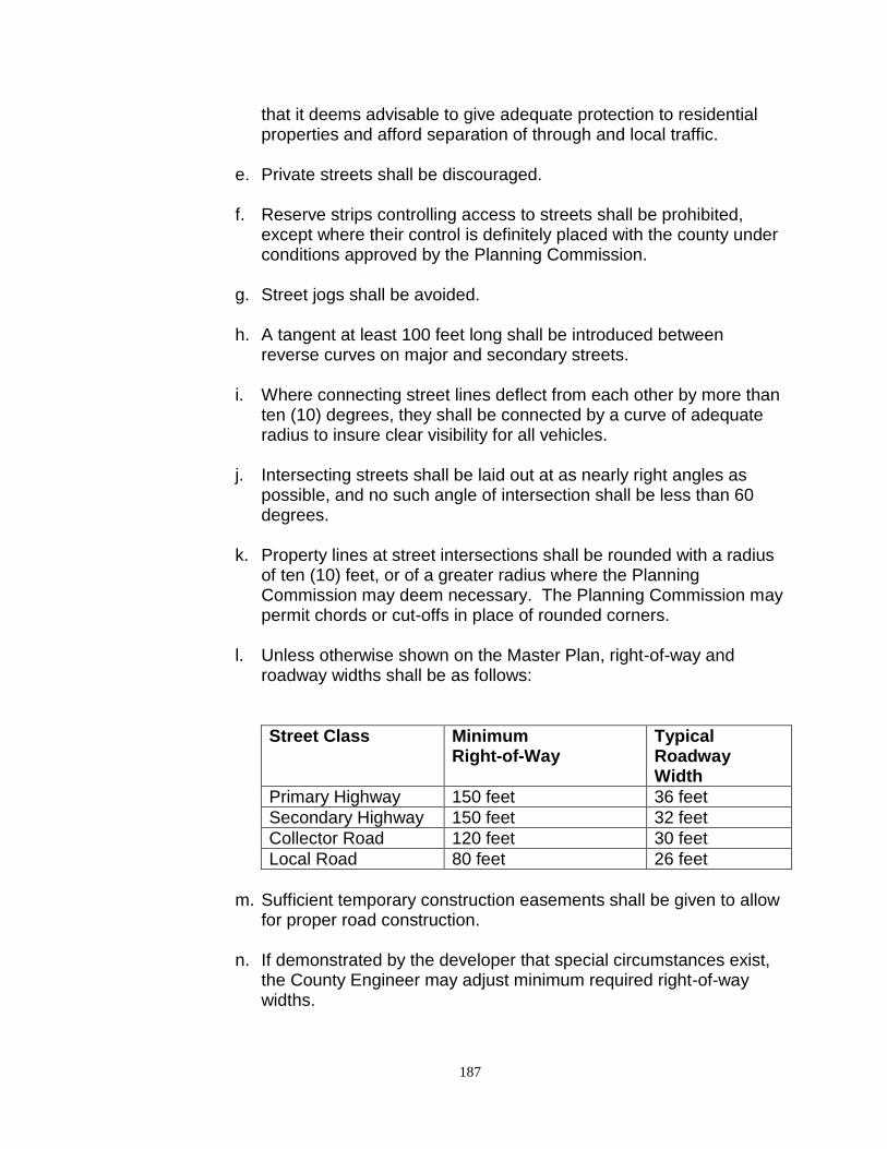
187
that it deems advisable to give adequate protection to residential properties and afford separation of through and local traffic.
e. Private streets shall be discouraged.
f. Reserve strips controlling access to streets shall be prohibited,
except where their control is definitely placed with the county under conditions approved by the Planning Commission.
g. Street jogs shall be avoided.
h. A tangent at least 100 feet long shall be introduced between reverse curves on major and secondary streets.
i. Where connecting street lines deflect from each other by more than ten (10) degrees, they shall be connected by a curve of adequate radius to insure clear visibility for all vehicles.
j. Intersecting streets shall be laid out at as nearly right angles as possible, and no such angle of intersection shall be less than 60 degrees.
k. Property lines at street intersections shall be rounded with a radius of ten (10) feet, or of a greater radius where the Planning Commission may deem necessary. The Planning Commission may permit chords or cut-offs in place of rounded corners.
l. Unless otherwise shown on the Master Plan, right-of-way and roadway widths shall be as follows:
Street Class Minimum Right-of-Way
Typical Roadway Width
Primary Highway 150 feet 36 feet
Secondary Highway 150 feet 32 feet
Collector Road 120 feet 30 feet
Local Road 80 feet 26 feet
m. Sufficient temporary construction easements shall be given to allow
for proper road construction.
n. If demonstrated by the developer that special circumstances exist, the County Engineer may adjust minimum required right-of-way widths.
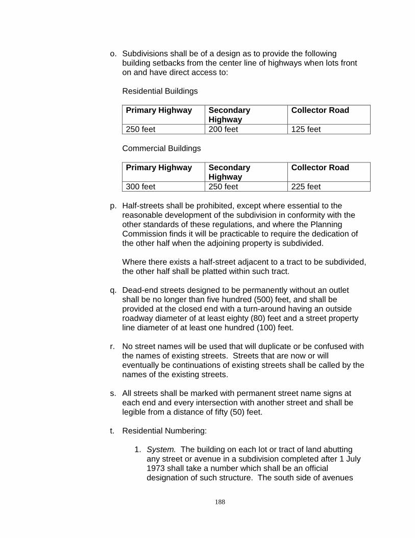
188
o. Subdivisions shall be of a design as to provide the following building setbacks from the center line of highways when lots front on and have direct access to: Residential Buildings
Primary Highway Secondary Highway
Collector Road
250 feet 200 feet 125 feet
Commercial Buildings
Primary Highway Secondary Highway
Collector Road
300 feet 250 feet 225 feet
p. Half-streets shall be prohibited, except where essential to the
reasonable development of the subdivision in conformity with the other standards of these regulations, and where the Planning Commission finds it will be practicable to require the dedication of the other half when the adjoining property is subdivided.
Where there exists a half-street adjacent to a tract to be subdivided, the other half shall be platted within such tract.
q. Dead-end streets designed to be permanently without an outlet
shall be no longer than five hundred (500) feet, and shall be provided at the closed end with a turn-around having an outside roadway diameter of at least eighty (80) feet and a street property line diameter of at least one hundred (100) feet.
r. No street names will be used that will duplicate or be confused with the names of existing streets. Streets that are now or will eventually be continuations of existing streets shall be called by the names of the existing streets.
s. All streets shall be marked with permanent street name signs at
each end and every intersection with another street and shall be legible from a distance of fifty (50) feet.
t. Residential Numbering:
1. System. The building on each lot or tract of land abutting any street or avenue in a subdivision completed after 1 July 1973 shall take a number which shall be an official designation of such structure. The south side of avenues
189
running east and west shall bear the odd numbers, and the north side of such avenues shall bear the even numbers. The east side of streets running north and south shall bear the odd numbers and the west side of such streets shall bear the even numbers. If two (2) buildings shall occupy a lot or tract of land, then a half number shall be given to the extra structure thereon.
2. Figures Used. The figures forming the numbers for all buildings shall be not less than three (3) inches in height and shall be conspicuously painted over the entrance to each building or may be painted, stamped or painted on glass, tin, or other substantial background or body and attached to such buildings in a conspicuous place over, or in close proximity to, the front entrance.
3. Duties of the County Building Official. The County Building Official shall designate the numbers of all houses and shall make a plat of all subdivisions in accordance with the preceding provisions and shall furnish the owner, occupant, or agent of each house now, or hereafter, built with its proper number.
4. Numbering Done by County, When: If the owner or other person in control or custody of a building fails, refuses, or neglects to comply with the requirements of this article, the Building Official shall cause proper numbers to be placed upon such building and the cost of so doing shall be collected from the owner or custodian of the building in a suit therefore by the County.
u. All streets with curb and gutter section shall have a grade of not
less than 0.5%. No major street with curb and gutter section shall have a grade in excess of 5%, and no other street of this type shall have a grade in excess of 10% unless approved by the County Engineer.
v. Adequate culverts shall be installed to handle all existing and projected drainage according to the storm water management plan as approved by the County Engineer. All stream crossings shall conform to Chapter 89-14 of the North Dakota Administrative Code titled “Stream Crossings”.
w. Gravel surfacing shall be spread the full width of the roadway. The
depth of gravel surfacing shall not be less than six (6) inches when compacted in place. Aggregates for gravel surfacing shall conform
190
to North Dakota State Highway Department standard specifications, Class 5 Aggregate. Sampling and testing shall be done by an independent testing firm prior to the placement of aggregate on the road. All costs for sampling and testing shall be the responsibility of the owner.
x. Written approval shall be obtained from the County Engineer prior
to the placement of aggregate on the road.
y. Minimum depth of hot bituminous pavement shall be six (6) inches in all Industrial Districts and four (4) inches in all other Districts compacted in place with proper base and subgrade. The owner shall present the County Engineer with two (2) sets of written plans and specifications for written approval before construction.
z. All approaches shall be graveled with Class 5 or Class 13 aggregate to an uncompact depth of two (2) inches. Gravel shall extend from the edge of the roadway to the property line.
aa. All roads shall be constructed and surfaced according to the Burleigh County Gravel Road Improvement Policy.
bb. All drainage under side streets, private drives, and approaches
must have culverts installed, with flared end sections, where required by the County Engineer, with a minimum size of fifteen (15) inches. Such culverts shall conform to the storm water management plan for the subdivision.
cc. All streets must be constructed to an adequate height to insure proper snow clearance and removal. Any deviation from the minimum road section must have the written approval of the County Engineer prior to construction. Protective covenants shall be filed by the owner to preserve the back slopes where the back slopes extend onto the lots.
dd. The County Engineer or Road Superintendent will inspect the completed roads in each subdivision before assuming responsibility and maintenance of the roads and streets to insure that the above standards and those of the zoning and subdivision regulations of the county have been fully complied with.
ee. No more than two (2) approaches onto a county or township road in any 1,320 feet of distance (1/4 mile) will be permitted without prior approval of the Board of County Commissioners and the County Engineer. No approach may be constructed without first having obtained an approach permit from the County Engineer.
191
ff. Minimum construction specifications shall be as illustrated, in
addition to conformance with engineering standards, except as approved by the Board of County Commissioners. Where necessary the width of the top shall be extended to provide for off-street parking.
gg. All road rights-of-way shall be seeded to grass or sodded from the
edge of the roadbed to the property line.
2. Easements
a. Easement across lots or centered on rear or side lot lines shall be provided at least fourteen (14) feet wide where necessary for utilities.
b. Where a subdivision or other development property is traversed by a water course (i.e., river, creek, coulee, drainage way, channel, or stream), a storm water easement or drainage right-of-way shall be provided conforming substantially with the flow lines of such water course, and such further width or construction, or both, as necessary to provide for the adequate conveyance of waters generated by the upstream and/or local watersheds. Such width shall be in accordance with the storm water management plan for the subdivision. The minimum width of such easements shall be twenty (20) feet. The maximum width shall be determined based on the watercourse’s conveyance capacity and/or its estimated floodplain based on the projected base flood elevation (i.e., the 100-year event or regional flood). Parallel roadways may be required in connection with such drainage easements.
3. Blocks a. Block length should usually not exceed 1,320 feet or be less than five hundred (500) feet. b. Pedestrian crosswalks not less than fifteen (15) feet wide may be required in blocks longer than nine hundred (900) feet where such crosswalks are deemed by the Planning Commission to be essential to provide circulation, or access to schools, playgrounds, shopping centers, transportation, or other community facilities. c. The width of blocks shall generally be sufficient to allow two (2) tiers of lots.

192
d. Blocks intended for business and industrial use should specifically be designated for such purposes with adequate space set aside for off-street parking and delivery facilities. e. Where frontage is on a major or secondary street, the long dimension of the block should front thereon.
4. Lots
a. Lot dimensions and areas shall be no less than shown in the
following tables, shall be no less than the minimum requirements of the underlying zoning district, and shall be sized to accommodate on-site wastewater, storm water and water supply facilities as soil conditions require.
Lots served by a central sanitary sewer system approved by the
North Dakota State Department of Health:
Minimum Width at Building Line
Minimum Depth Minimum Area
80 feet 120 feet 20,000 square feet
Lots not served by a central sanitary sewer system approved by the North Dakota State Department of Health:
Minimum Width at Building Line
Minimum Depth Minimum Area
150 feet 200 feet 65,000 square feet
b. Platting of lots for commercial purposes should be avoided in favor of the comprehensive design of a balanced shopping center providing off-street parking and loading space.
c. All lots shall abut on a street or other public right-of-way.
d. Double frontage and reverse frontage lots shall be avoided.
e. Corner lots shall be of extra width sufficient to maintain building lines on both streets.
f. Side lot lines shall be approximately at right angles or radial to street lines.
193
g. A screen planting easement may be required between residential and commercial or industrial lots.
5. Covenants
There shall be required to be filed on each lot in any new subdivision a covenant to require that all dogs must be leashed, fenced, or under the control of the owner at all times. Said covenants shall be placed in effect for all time to come.
Section 7. Waivers
1. Hardship
a. Where it can be shown in the case of a particular proposed
subdivision, the strict compliance with the requirements of these regulations would result in practical difficulty or unnecessary hardship to the sub divider because of unusual topography, or other such conditions would prohibit the achievement of the objective of these regulations, then the Planning and Zoning Commission may waive the requirements so that substantial justice may be done and the public interest secured; provided that such waiver will not have the effect of nullifying the intent and purpose of these regulations, or of the Master Plan.
b. In no case shall any waiver be more than a minimum easing of the requirements; in no case shall it have the effect of reducing the traffic capacity of any major or secondary street; in no case shall it conflict with existing zoning regulations.
c. In granting waivers, the Planning and Zoning Commission may
require such conditions as will, in its judgment, secure substantially the objectives of the standards and regulations so affected.
2. Planned Unit Development
These regulations may be modified by the Planning and Zoning Commission in the case of a plan for a new town or a complete community or neighborhood unit, with a building and development program which, in the judgment of the Planning and Zoning Commission, provides and dedicates adequate public open spaces and improvements for the circulation, recreation, education, light, air and service needs of the tract when fully developed and populated, and which provides such covenants, financial guaranties, and other legal assurances that the plan will be followed and will be achieved. See Article 20 for details.
194
Section 8. Penalties
1. In accordance with the provisions of Chapter 40-48 of the North Dakota Century Code, whoever, being the owner or agent of the owner of any land located within the territory of a subdivision subject to the approval of the Planning and Zoning Commission of Burleigh County and the Board County of Commissioners, transfers or sells, or agrees to sell any land by reference to or exhibition of or by other use of a plat of subdivision, before such plat has been approved by said Planning and Zoning Commission in accordance with the requirements of these regulations and recorded or filed for record as so approved in the office of the County Register of Deeds, shall, forfeit and pay a penalty of $100.00 for each lot or parcel so transferred or sold or agreed or negotiated to be sold. The description of such lot or parcel by metes and bounds shall not exempt the transaction from such penalties or the remedies herein provided. Such fine and forfeiture shall not act to stop Burleigh County from enjoining such transfer or sale or agreement by action from injunction in a court of equity jurisdiction.
2. In accordance with Section 11-33-21 of the North Dakota Century Code, a
violation of any provision of this ordinance shall constitute the
maintenance of a public nuisance and upon conviction there shall be a
penalty of a fine of not more than $200.00 or imprisonment in a county jail
for not more than 30 days, or by both such fine and imprisonment.
Section 9. Undergrounding of Utilities All new subdivision construction shall utilize underground utility lines and services in a common trench, except for water and sewer services, whenever practical and possible. Section 10. Soil Erosion Control In all Zoning Districts, except A Agricultural, the following regulations shall apply:
1. Before any developer or other firm, person or agency changes or alters the contour of any land proposed to be subdivided, developed or changed in use by grading, excavating or the removal of the natural topsoil, trees, or other vegetative covering thereon for the purpose of development, construction or other purposes, he or his agent shall develop a plan to control erosion and sedimentation which can be expected to occur if appropriate precautions are not taken to arrest such waste and soil depletion.
2. Erosion and sedimentation control shall be exercised throughout the time
of excavation, landfill and/or construction. No such work shall be finally
195
approved until after appropriate seeding, sodding, plantings, mulching or other appropriate erosion control measures have been taken.
3. The Board of County Commissioners may require the posting of a
performance bond by any such persons who desire to change the contour of the land. Such bond shall be in the amount he reasonably expects the cost to be to the County to enter upon the property for the purpose of taking corrective action where such developer or other person has failed to satisfactorily control either erosion or sedimentation.
4. The following erosion control measures shall be observed during
development of property when changing the contour of the land:
a. The smallest practical area of land will be exposed at any time during development.
b. When land is exposed during development, the exposure will be kept to the shortest practical period of time. Top soil shall be removed and stockpiled during grading/development activities and replaced as needed upon completion in order to facilitate re-vegetation. The site shall be re-vegetated promptly upon completion of grading activities.
c. Where necessary, temporary vegetation and/or mulching will be used to protect areas exposed during development.
d. Sedimentation basins will be installed and maintained to remove sediment from run-off waters from land undergoing development or substantial changes of grade.
e. Provisions are to be made to effectively accommodate the increased run-off caused by changed soil and surface conditions during and after development.
f. Permanent final vegetation and structural development are to be installed as soon as practical in the development.
g. The development plan is to be adapted to the topography and soils so as to create the least erosion potential.
h. Wherever feasible, trees, shrubs, and natural vegetation are to be retained and protected to control erosion.
5. Enforcement of erosion control shall include periodic onsite inspections of
the proposed and/or installed Best Management Practices (BMP’s) or measures included in the storm water management plan, by the County
196
Building Official, County Planner or County Engineer. Should any such inspection result in a determination of “non-compliance” with these erosion control regulations, the contractor and owner/developer will be notified of the necessary corrective actions. Should such corrective actions not be implemented within a specified time frame, as designated in the notice, the contractor will be required to cease and desist with any additional work on the project or within the development, with the exception of the construction of previously approved building permits on parcels or lots sold to individuals not directly involved in the development.
Any damages to public facilities resulting from “non-compliance” with the erosion control regulations shall be corrected by the owner/developer or payment made to the County for the extent of such damages. Costs incurred by the County to correct such damages shall be paid by the owner/developer or may be assessed to the development properties.
Section 11. Plat Vacation Procedures Any property owner desiring to vacate a part of a previously approved and recorded plat must follow the same procedures as required for plat approval, as outlined in Article 33, Section 5, except for platting that qualifies as a minor change to an existing plat under Section 12 of the 1972 Amended Zoning Ordinance of Burleigh County, North Dakota, entitled "Subdivision Regulations Procedures". Section 12. Minor Changes to Existing Plats All proposed changes to existing plats shall be submitted to the Planning and Zoning Department for review. Changes that affect more than three (3) lots shall proceed through the platting process described in Article 33. Changes within an existing plat that affect three (3) lots or less (and are ruled as minor changes by the Planning Department) may be made by meeting the following requirements:
1. The subdivider shall apply in writing on the required form to the Planning Department for approval of a minor plat modification at least thirty (30) days prior to the Board of County Commissioner’s meeting at which it is to be acted upon.
2. The Planning Department will review the proposed changes with the
County Planner, County Auditor and County Engineer and will compile their comments into a recommendation to the Board of County Commissioners.
3. After receipt of all items required for the application for approval of a minor plat modification, the Planning Department shall give notice of a public hearing on the proposed minor plat modification by advertising the time
197
and place of the hearing in a newspaper of general circulation in the County of Burleigh once a week for two (2) weeks prior to the date of such hearing. The public hearing shall be conducted at a regular scheduled Board of County Commissioners meeting.
4. Not less than ten (10) days prior to the scheduled public hearing all known
adjacent property owners within 1,320 feet shall be notified by letter of the hearing.
5. Following the public hearing, the Board of County Commissioners may approve, approve subject to certain stated conditions being met, or deny the application. If approved, changes will be recorded against all affected lots.
Section 13. Storm Water Management This section establishes requirements for storm water management systems within the zoning jurisdiction of Burleigh County. The purpose of these standards are as follows:
1. To protect and promote the health, safety, and welfare of the people and property through effective stormwater management practices. 2. To provide for the protection of surrounding or adjacent properties from water and wind erosion through the use of best management practices that meet the intended use; and 3. To provide for adequate stormwater system analysis and appropriate stormwater system design as necessary to protect public and private property, water quality, and existing natural resources. This section establishes and provides for the following stormwater management criteria: 1.0 - Scope Every applicant for a building permit, subdivision approval, or a permit to allow land disturbing activities for an approved development must submit a Stormwater Management Plan including an Erosion and Sediment Control Plan to the County Engineer. No building permit, subdivision approval, or permit to allow land disturbing activities shall be issued until approval of the Stormwater Management Plan or a waiver of the approval requirement has been obtained in strict conformance with the provisions of this Section. In addition, no land disturbing activities shall occur until all initial best management practices (BMPs) have been implemented. A waiver of the Stormwater Management Plan does not relieve the applicant from the stormwater permit requirements, including permit fees and an approved Erosion and Sediment Control Plan.
198
Exemptions to the requirements of this section include:
1. Any part of a subdivision if a plat of the subdivision has been approved by the Board of County Commissioners and recorded with the County Recorder on or before the effective date of this section (January 1, 2014). A stormwater permit for land disturbing activities on such properties may still be required in accordance with this section; 2. Land disturbing activity involving the construction of a single- family or a two-family dwelling; 3. A parcel for which a building permit has been approved on or before the effective date of this section; 4. Installation of a fence, sign, telephone, and electric poles and other kinds of posts or poles; or 5. Emergency work to protect life, limb, or property.
2.0 - Stormwater Management Plan 2.1 Application 1. Application Procedure. a. Written Application. A written application for Stormwater Management Plan approval, along with the proposed Stormwater Management Plan, shall be filed with the County Planning Department. The application shall include a statement indicating the grounds upon which the approval is requested, that the proposed use is permitted in the underlying zoning district, and adequate evidence showing the proposed use will conform to the standards set forth in this section. b. Copies. Two sets of legible copies of the drawings and required information shall be submitted to the County Planning Department. Plans shall be prepared to a scale appropriate to the site of the project and suitable for the review to be performed. c. Waiver. The County Engineer may waive any requirement of this section upon making a finding that compliance with the requirement will involve an unnecessary non-economic hardship, and the waiver of such requirement will not adversely affect the standards and requirements put forth in this section. The
199
County Engineer may require as a condition of the waiver, such dedication or construction, or agreement to dedicate or construct, as may be necessary to adequately meet the said standards and requirements. 2. Contents of Stormwater Management Plan. At a minimum, the Stormwater Management Plan shall contain the following information: 1. Written Report. A written report discussing pre- and post-development hydrology and hydraulic analysis, erosion and sedimentation control during and after construction, protective measures for proposed and existing structures, and water quality concerns. The contents of the report shall contain the following information: a. The name and address of the applicant; b. The section, township and range; c. The acreage of the development and the acreage of the disturbed area; d. A description of the existing soils on the site, if necessary, including a map indicating soil types of the areas to be disturbed, information on the suitability of the soils for the type of development proposed, potential for erosion, the type of stormwater management system proposed, and any remedial steps to be taken by the developer to render the soils suitable; and e. The current land use of the area in which the site is located. 2. Maps. The following maps shall be included with the written report. Each map shall contain a north point indicator, date, scale of drawing, and the datum. a. Location Map. The location of the tract at a scale sufficient to clearly identify the location of the property and giving such information as the names and numbers of adjoining roads, railroads, utilities, subdivisions, towns, districts or other defining landmarks, and a watershed boundary map illustrating the project site location as a subwatershed within the watershed of the larger or major drainage basin. b. Existing Site Conditions Map. A map of existing site conditions showing the site and immediately adjacent areas, including:
200
i. Existing topography with a contour interval appropriate to the topography of the land, but in no case having a contour interval greater than two (2) feet; ii. A watershed boundary map illustrating the subwatershed(s) both above and within the site or development; iii. A delineation of streams, rivers, public waters and the presence or absence of wetlands located on and immediately adjacent to the site, including depth of water, a general description of vegetative cover found within the site, a statement of general water quality, and any classification given to the water body by state or federal agencies; iv. Location and dimensions of existing stormwater drain systems and natural drainage patterns on and immediately adjacent to the site delineating in which direction and at what rate stormwater is conveyed from the site, identifying the receiving stream, river, public ditch, or wetland, and setting forth those areas of the unaltered site where stormwater collects or passes; v. Current extent of vegetative cover and a clear delineation of any vegetation proposed for removal; and vi. The 100-year flood and floodway as designated on a FEMA published digital flood insurance rate map (DFIRM) or as determined by a site specific analysis. 3. Final Site Conditions Map. A plan of final site conditions on the same scale as the existing site conditions map showing the proposed site changes shall be provided, including: a. The proposed final grading plan shown at contours at the same interval as provided above or as required to clearly indicate the relationship of the proposed changes to existing topography and remaining features. This grading plan should also indicate areas of cut and fill activity greater than three (3) feet; b. A watershed boundary map illustrating the proposed subwatershed(s) both above and within the site or development; c. A drainage plan of the developed site delineating the direction of stormwater runoff and how it will be conveyed from the site and setting forth the areas of the site where stormwater will be collected along with the method of collection including ponds, storm sewer or channels; d. The proposed size, alignment, and intended use of any structures to be erected on the site;
201
e. A clear delineation of all areas which shall be paved or surfaced, including a description of the surfacing material to be used; and f. Any other information pertinent to the particular project which is necessary for the review of the project. 4. Erosion and Sediment Control Plan. The erosion and sediment control plan shall include the following information: a. The locations and dimensions of all proposed land disturbing activities. b. Approximate locations of all stockpile areas; c. Location and detailed description of all construction site best management practices (BMPs) necessary to meet the requirements of this section; d. A schedule of anticipated starting and completion dates for each phase of activity, including the installation of construction site best management practices (BMPs) needed to meet the requirements of this section; and e. Provisions for maintaining the construction site best management practices (BMPs) throughout all phases of construction including prior to, during, and after construction. This shall include the installation of permanent control measures and the removal of temporary BMPs. 5. Certification. All stormwater management plans, drawings, specifications, and computations for stormwater management facilities submitted for review shall contain a validated seal and be signed by a Professional Engineer registered in the State of North Dakota. This requirement will be met as part of the properly completed stormwater Management Plan. 2.2 Review. 1. Process. Stormwater Management Plans meeting the requirements of this section shall be reviewed by the County Engineer. After evaluation of the Stormwater Management Plan, the County Engineer shall approve, approve with conditions, or deny the Stormwater Management Plan. If a particular stormwater management plan involves a drainage area of 80 acres or more, a complex application or has the potential for significant controversy, the County Engineer may bring the proposed stormwater management plan before the Burleigh County Water Resource District for consideration and public comment.
202
2. Conditions. A Stormwater Management Plan may be approved subject to compliance with conditions reasonable and necessary to insure that the requirements contained in this section are met. Such conditions may, among other matters, limit the size, kind or character of the proposed development, require the construction of structures, drainage facilities, storage basins and other facilities, require replacement of vegetation,establish required monitoring procedures, stage the work over time, require alteration of the site design to insure buffering, require the acquisition of certain lands or easements, and require the conveyance to public entity of certain lands or interests therein. The County Engineer may specify special requirements for specific watersheds within the County. The nature of these requirements will be subject to the unique environmental and natural resource environment of each subwatershed. Approval of a plan shall bind the applicant to perform all of the conditions and requirements of the plan prior to any land disturbing activities. 2.3 Approval Standards. 1. General. This section describes approval standards against which proposed Stormwater Management Plans will be measured. A Stormwater Management Plan which fails to meet the standards contained in this section shall not be approved by the County Engineer. Other standards, such as state and federal standards, shall also apply. If two standards of different agencies conflict, the more restrictive standards shall apply. It shall be the responsibility of the applicant to obtain any required permits from other governmental agencies having jurisdiction over the work to be performed. Typically, such agencies could include the Burleigh County Water Resource District, the State Water Commission and State Engineer’s Office, the State Department of Transportation, the State Health Department, the State Historical Preservation Officer, the U.S. Army Corps of Engineers, the U.S. Environmental Protection Agency, and possibly others. The following sections describe routine approval standards to be used in evaluating a proposed Stormwater Management Plan. 1. Stormwater Design Standards Manual. The Burleigh County Stormwater Design Standards Manual, contains the principal standards and design criteria for developing an effective and acceptable Stormwater Management Plan. The Manual contains detailed criteria for hydrologic evaluations, the design of stormwater management system facility components, water quality protection standards, instructions for the development of an erosion and sedimentation control plan, and requirements for easements and rights-of-way.
203
2. Models/Methodologies/Computations. Hydrologic models and design methodologies used to determine runoff conditions and to analyze stormwater management structures and facilities shall be approved in advance by the County Engineer. 3 Construction Plans and Specifications for Public Facilities. The construction plans and specifications prepared for the construction of public stormwater management facilities must: a. Be consistent with the Stormwater Management Plan approved by the County Engineer. b. Be in conformance with the requirements of Burleigh County any other necessary permits issued by other governmental agencies. c. Be sealed and signed by a Professional Engineer registered in the State of North Dakota. d. Be submitted to the County Engineer for approval. e. Contain a drawing or drawings delineating the erosion and sediment control plan, including details of silt fences, storm drain inlet protection, and other best management practices (BMPs). The construction specifications shall contain technical specifications describing erosion, sedimentation and water control requirements during and after construction operations. No construction may commence until the construction plans and specifications have been approved by the County Engineer and all other applicable permits and approvals are received from outside agencies 4. Stormwater Management Criteria for Permanent Facilities. Stormwater control facilities included as part of the final design for a permanent development shall be addressed in the Stormwater Management Plan and shall meet the following criteria: a. Pre-versus Post Hydrological Response of Site. An applicant shall install or construct, on or for the proposed land disturbing or development activity, all stormwater management facilities necessary to manage increased runoff so that the two (2) year, ten (10) year and one hundred (100) year storm peak discharge rates existing before the proposed development shall not be increased and accelerated channel erosion will not occur as a result of the proposed land disturbing or development activity.
204
b. Natural Features of the Site. The applicant shall reduce the need for stormwater management facilities by incorporating the use of natural topography and land cover such as wetlands, ponds, natural swales and depressions as they exist before development to the degree that they can accommodate the additional flow of water without compromising the integrity or quality of these natural features. c. Stormwater Management Strategies. The following stormwater management practices shall be investigated in developing a Stormwater Management Plan: i. Natural infiltration of precipitation and runoff on-site, if suitable soil and geological conditions are available. The purpose of this strategy is to encourage the development of a Stormwater Management Plan that encourages natural infiltration. This includes providing as much natural or vegetated area on the site as possible, minimizing impervious surfaces, and directing runoff to vegetated areas rather than to adjoining streets, storm sewers and ditches. This shall include the identification of areas with known high water tables, natural springs and other areas with ground water implications. ii. The flow attenuation by use of open vegetated swales and natural depressions. iii. Stormwater detention facilities. iv. Stormwater retention facilities (on a case by case basis). v. Storm sewer facilities. A combination of successive practices may be used to achieve the applicable minimum control requirements specified in the above strategies. Justification shall be provided by the applicant for the method selected. 5. Adequacy of Outlets. The adequacy of any outlet used as a discharge point for proposed stormwater management facilities must be assessed and documented to the satisfaction of the County Engineer. The hydraulic capacities of downstream natural channels, reaches, storm sewer systems, or streets shall be sufficient to receive post-development runoff discharges and volumes without causing increased property damages, an increase in the established base flood elevation (BFE), or a change in the conveyance of the base flood. If a floodplain or floodway has not been established by the Federal Emergency Management Agency, then the applicant shall provide a documented analysis and estimate of the base flood elevation as certified by a Professional
205
Engineer registered in the State of North Dakota. In addition, projected velocities in downstream natural or manmade channels shall not exceed that which is reasonably anticipated to cause erosion unless protective measures acceptable to the County Engineer are approved and installed as part of the Stormwater Management Plan. The assessment of outlet adequacy shall be included in the Stormwater Management Plan and shall be certified by a Professional Engineer registered in the State of North Dakota. 6. Stormwater Detention/Retention Facilities. Stormwater detention or retention facilities proposed to be constructed in the Stormwater Management Plan shall be designed according to the most current technology as reflected in the Design Standards Manual. 3.0 Stormwater Permits. 1. Stormwater Management. It is unlawful to initiate land development, land disturbing, or other activities which result in an increase in stormwater quantities, degradation of stormwater quality, or restriction of flow in any storm sewer system, open ditch or natural channel, stormwater easement, water body, or wetland outlet within the jurisdiction of the County, without having first complied with the terms of this section. 2. Stormwater Permits. a. Mandatory Permits. Any person proposing a development or project which involves land development, land disturbing, or other activities as defined in this section, shall obtain a stormwater permit before initiating those activities. If the stormwater management plan submittal requirement is waived or deemed exempt by the County Engineer, a stormwater permit must be obtained in accordance with this section. b. Permit Application. All persons’ subject to meeting the requirements for a mandatory stormwater permit shall complete and file with the County Planning Department an application in the form prescribed by the County Planning Department and accompanied by a fee established by the Board of County Commissioners. The permit application shall be accompanied by the following: i. A phased Erosion and Sediment Control Plan; ii. A final grading plan; iii An approved, or revised Stormwater Management Plan as prescribed under this section or a waiver of this requirement;
206
iv. Verification that all best management practices (BMPs) have been installed; and v. The applicable fee. The County Engineer will evaluate the data furnished as part of the Stormwater Management Plan and may require additional information. After evaluation and acceptance of the Stormwater Management Plan, the County Engineer may issue a stormwater permit subject to any terms and conditions deemed necessary. 1. Permit Conditions. Stormwater permits are issued subject to all provisions of this section and all other applicable regulations, user charges and fees established by the County. Permits may contain any of the following conditions: a. Limits on the maximum rate of stormwater discharge; b. Limits on water quality degradation of stormwater discharge; c. Requirements for the installation, operation and maintenance of stormwater detention/retention facilities; d. Compliance schedule; e. Other conditions as deemed appropriate by the County Engineer to insure compliance with this section. 2. Permit Duration. Permits must be issued for a time period specified by the County Engineer. The applicant shall apply for permit renewal a minimum of thirty (30) days prior to the expiration of the applicant’s existing permit. The terms and conditions of a permit are subject to modification by the County Engineer during the term of the permit as set forth herein. Failure to renew the permit prior to the expiration date will require the permittee to pay a late fee as prescribed by the County Engineer. While the permit may have expired, the permittee remains responsible for the activities and site governed under the permit until the permit is terminated. 3. Inspection. The County Engineer may inspect the stormwater management facilities of any permittee to determine compliance with the requirements of this section. A permittee shall allow the County Engineer to enter upon the premises at all reasonable hours for the purposes of inspection, sampling or record examination. The County Engineer shall be allowed to set up equipment on the permittee’s premises as required for the purpose of collecting samples and flow recording.
207
4. Stop Work Order. The County Engineer shall have authority to issue a stop work order, ordering suspension of all work and activity at the site, upon finding that an actual or threatened discharge exists or when such conditions present an imminent or substantial danger to the health or welfare of persons downstream, the environment, natural resources, stormwater quantity, water quality, and/or environmentally sensitive lands. Upon issuance of a stop work order, all work in the area covered by the stormwater permit, if a permit has been issued, shall cease immediately. If any person notified of such stop work order fails to comply, the County shall commence whatever steps are necessary to obtain compliance. The County Engineer may lift the stop work order upon proof of compliance with all plan or permit requirements and conditions. Whenever the County Engineer issues a stop work order and declares the situation to be an emergency, the County Engineer shall serve a notice and order on the person performing the work personally, or by registered or certified mail. The person performing the work, owner or permittee has the right to an informal hearing before the County Engineer by making an appointment with the County Engineer. The informal hearing must be held within five (5) days of service of the notice and order. Following the hearing, the County Engineer may affirm, modify or rescind the stop work order. 5. Suspension of Stormwater Management Plan or Stormwater Permit. The County Engineer shall have authority to suspend a stormwater management plan or a stormwater permit upon finding that an actual or threatened discharge exists or when such conditions present an imminent or substantial danger to the health or welfare of persons downstream, environment, natural resources, stormwater quantity, water quality, and/or environmentally sensitive lands. Upon issuance of suspension notice and order, all work in the area covered by the permit, shall cease immediately. If any person fails to comply with the suspension order, the County shall commence whatever steps are necessary to obtain compliance. The County Engineer may lift the suspension order upon proof of compliance with all stormwater management plan or stormwater permit conditions. 6. Appeal. All decisions of the County Engineer dealing with violations of a stormwater permit or this section are subject to appeal to the Board of County Commissioners upon written notice of appeal filed within fifteen (15) days of issuance of the decision. 7. Hearing. Upon receiving the notice of appeal the Board of County Commissioners shall set a date for a hearing within thirty (30) days of receipt of the notice of appeal. Notice of the time and place for the

208
hearing must be served upon the appellee by certified mail or in person not less than five (5) days prior to the hearing.
209
ARTICLE 34 MINIMUM HOUSING STANDARDS Section 1. Resolution WHEREAS, in the county-zoned portions of Burleigh, there are, or may in the future be, buildings or structures which are dilapidated, unsafe, dangerous, unsanitary, a menace to the health, morals, safety and general welfare of the people of this County, and which might tend to constitute a fire menace and which are a public nuisance. BE IT THEREFORE RESOLVED BY THE BOARD OF COMMISSIONERS OF THE COUNTY OF BURLEIGH THAT THE FOLLOWING SHALL BE: An Ordinance providing for the vacation, removal, repair or demolition of any building or structure which is, or threatens to be, a public nuisance, dangerous to the health, morals, safety or general welfare of the people of the County of Burleigh, or which might tend to constitute a fire menace; and for the assessment of the cost of vacation, removal, repair or demolition thereof as a county lien or assessment against such premises, and to provide for the recovery of such costs in an action at law.
Section 2. Inspection of Dwellings, Dwelling Units, Rooming Units and Premises
1. The County Health Office or Building Inspector is hereby authorized and directed to make inspections when necessary to determine the conditions of all dwellings, dwelling units, rooming units, and premises located within the county zoned portions of the County of Burleigh, in order that they may perform their duty of safeguarding the health and safety of the occupants of such dwellings and the general public.
2. For the purpose of making such inspections, the County Health Officer or Building Inspector is hereby authorized to enter, examine and survey, during normal working hours only, all dwelling units, and premises located within the county zoned portions of the County of Burleigh when necessary for the purposes of determining whether any conditions exist which render such places as substandard within the terms of this Ordinance. The County Health Officer or Building Inspector is further authorized to inspect any building, wall or structure about which complaints are filed by any person to the effect that a building, wall or structure is or may be existing in violation of this Ordinance.
3. The owner or occupant of every dwelling, dwelling unit, rooming unit, or
210
the person in charge thereof shall give the County Health Office or Building Inspector access to such dwelling, dwelling unit, rooming unit and its premises, at reasonable times for the purpose of inspection.
4. Each occupant of a dwelling or dwelling unit shall give the owner thereof, or his agent or employee, access to any part of such dwelling, dwelling unit, or its premises, at reasonable times for the purpose of making such repairs and/or alterations as are necessary to effect compliance with the provisions of this Ordinance, or any lawful order issued pursuant to the provisions of this Ordinance.
5. No inspection of, or access to, any premises shall be effected in the absence of any adult person responsible for or dwelling within the premises, or an adult person designated by said person to provide access for an inspection.
Section 3. Minimum Requirements for Dwelling Units No person shall occupy as an owner, occupant, or let to another for occupancy any dwelling unit for the purpose of living, sleeping, or eating therein, which does not comply with the following requirements:
1. Dwelling Unit for Human Habitation
The County Health Officer or Building Inspector shall determine that a dwelling is unfit for human habitation or a building is substandard, if he finds that any of the following conditions exist:
a. Construction and Maintenance
1. Building supporting members which show thirty-three (33)
percent or more of damage or deterioration.
2. Buildings that have interior or outside walls or coverings which show fifty (50) percent or more damage or deterioration.
3. Buildings which have floors or roofs with improperly distributed loads, which are overloaded, or which have insufficient strength to be reasonably safe for the purpose used, or such framing members deflect over 1/360 of the span.
4. Buildings which have been damaged by fire, wind or other causes that endanger the lives, safety or welfare of the occupants or other people of the County.
211
5. Buildings which are dilapidated, decayed, unsanitary or in
disrepair which are likely to cause sickness or disease, or to cause injury to the health, safety or welfare of the occupants or other people of the County.
6. Buildings in which each living unit does not have a safe and unobstructed means of egress leading to a safe and open space at ground level.
7. Buildings which have defects therein, increasing the hazards of fire, accidents, or other calamities, such as lack of adequate ventilation, light, heating, or sanitary facilities as endangering the health, morals, safety or general welfare of the occupants or other residents of the County.
8. Buildings which are in violation of any provisions of fire prevention, or ordinances of the County of Burleigh.
9. Buildings in which the interior walls, ceilings, and floors of all habitable rooms are not of durable material, in good repair, and well painted.
10. Buildings in which the exterior walls are not covered with an approved type of sheathing , stucco, brick or other recognized material in good repair.
11. Buildings or premises that violate any ordinance of the County relative to sanitation and safety.
12. Dwelling units in which the bedrooms or bathrooms are not available through hallways or other means to assure the privacy of the occupants.
b. Lighting and Ventilation
1. Each habitable room, including toilets and bathrooms, shall
have not less than one (1) window. The window area in each of the said rooms shall not have less than ten (10) percent of the floor area in glass and at least one-half (1/2) of the minimum allowable window area shall be designed, built, and maintained so that it may be opened for the admission of outside air.
2. Every public hall and stairway in every two-family dwelling, multi-family dwelling and rooming house shall be adequately
212
ventilated.
3. The County Health Officer or Building Inspector upon presentation of plans and specifications or a mechanical ventilation system showing that the same provides fresh air equivalent to, or better than, would be provided by the window installation provided in Subsection 1 above, may authorize the use of such mechanical ventilation system in lieu thereof. Any such mechanical ventilation system shall be maintained in good working and operating condition at all times.
4. The windows in all habitable rooms shall open directly upon a yard, alley, street or court. In case of windows on courts, there shall not be less than three (3) feet of clear space between the outside of the windows and the property line.
5. All windows, doors and other apertures opening to the outside or to other unscreened areas shall be equipped with screens of Number 16 mesh or finer, and the same shall be installed and maintained with no loose frames or edges and free from breaks and tears. During the fly season, such screens are to be installed from May 1 to October 1 of each year.
c. Electrical Facilities
1. Every public hall and stairway in every two-family dwelling,
multi-family dwelling, and rooming house shall be adequately lighted at all times except that such lighting system be turned off by conveniently located switches during the daylight hours.
2. Every dwelling within three hundred (300) feet of a power line shall be supplied with electricity.
3. Every existing habitable room shall contain at least two (2) separate floor or wall type electrical convenience outlets. Every kitchen shall contain two (2) twenty (20) amp outlets.
4. Every water closet compartment, bathroom, laundry room furnace room and public hall shall contain at least one (1) supplied ceiling or wall type electrical light fixture.
5. Every outlet and fixture shall be properly installed and maintained in good working condition.
213
d. Plumbing and Sewage
1. Each dwelling unit shall be provided with not less than one
(1) kitchen sink. Each dwelling unit shall have access to a full bathroom. A full bathroom shall consist of at least one (1) stool, one (1) lavatory, one (1) bath tub or shower; not more than one (1) dwelling unit may share one (1) full bathroom. Each bathroom shall be enclosed by walls, ceiling, and doors, to afford privacy.
2. All joints, pipes, valves and connections of all plumbing and sewers shall be installed in accordance with the State Plumbing Code and be maintained in good working condition.
3. The sink, tub bath or shower bath, and flush type water closet herein required shall be accessible without leaving the shelter of the roof of the building in which the dwelling unit is located and without passing through any other dwelling unit.
4. Floors and walls in any room where the required sink, bath tub or shower bath and flush type water closet are installed shall be built and maintained so as to be reasonably impervious to water.
5. Every kitchen sink, lavatory, shower or bath tub, and basin shall be connected to both hot and cold running water and the hot water heating facilities shall be capable of providing hot water at least 120 degrees Fahrenheit at each required hot water faucet.
e. Heating
1. Every dwelling or dwelling unit shall have heating facilities
which are properly installed, maintained in safe and good working conditions, and be capable of safely and adequately heating all habitable rooms, bathrooms, and water closet compartments located therein to a temperature of at least 68 degrees Fahrenheit at a distance of three (3) feet above the floor lever, under ordinary minimum winter conditions.
f. General Conditions
1. Every foundation, floor, wall, ceiling and roof shall be
reasonably weather-tight, rodent-proof and shall be capable
214
of affording privacy and shall be kept in good repair.
2. Every window, exterior door and basement hatchway shall be reasonably weather-tight, water-tight, rodent-proof and shall be kept in sound working condition and good repair.
3. Yards adjacent to any dwelling shall be graded to drain water off the lot or into a drainage system on the lot, no standing or stagnant pools of water shall be permitted on any yard or lot.
4. Every supplied facility, piece of equipment or utility which is required under this Ordinance shall be so constructed or installed that it will function safely and effectively and shall be maintained in a satisfactory working condition.
5. No owner, operator or occupant shall cause any service facility, equipment, or utility which is required under this Ordinance to be removed from, shut-off, or disconnected in any occupied building or dwelling unit except for such temporary interruption as may be necessary while actual repairs or alterations are in the process or during temporary emergencies.
6. Porches, exterior stairways, steps, walkways and sidewalks shall be in good repair and free from hazards.
7. Out buildings, retaining walls, fences and accessory buildings shall comply with the provisions of this Ordinance regarding repair, maintenance and usage.
2. Rooming Houses
No person shall operate, or permit to be occupied, a rooming house which does not comply with the requirements of Section 3, Subsection 1.
The provisions of the Ordinance shall be applicable to each rooming house and rooming unit. For the purpose of this section, whenever in the previous section the term "dwelling" is used, it shall mean "rooming house", and whenever the term "dwelling unit" is used, it shall be construed to mean "rooming unit".
3. Basements and Cellars
a. No basement or cellar space shall be used for a dwelling unit or
215
habitable room unless:
1. The floors and walls are damp-proofed and impervious to leakage of underground or surface moisture and insulated against dampness.
2. Total of the window area in each room is equivalent to ten
(10) percent of the floor space of such room, or no less than that considered adequate and reasonable as compared to the floor space of such room.
3. The total openable window area for ventilating each room is
equivalent to at least five (5) percent of the floor space of such, or where there is supplied some other device affording equivalent ventilation and approved by the County Health Officer or Building Inspector.
4. Every window which is below the grade of the ground
adjoining such window shall have light wells or areaways extending at least twenty (20) inches out from said window throughout the entire width of the window.
5. Walls, ceilings and floors of the basement rooms shall
comply with Section 3, Subsection 1 of this Ordinance. Section 4. Responsibility of Owners and Occupants
1. Every owner of a dwelling or dwelling unit containing two (2) or more dwelling units shall be responsible for maintaining in a clean and sanitary condition the shared or public areas of the dwelling and premises.
2. Every occupant of a dwelling or building shall keep in a clean and sanitary condition that part of the dwelling, dwelling unit, and premises thereof which he occupies and controls.
3. Every occupant of a dwelling or dwelling unit shall dispose of all rubbish in a clean and sanitary manner by placing it in rubbish containers.
4. No owner shall occupy or let any vacant dwelling unit unless it is clean, sanitary, fit for human habitation and not in violation of this Ordinance.
5. Every occupant of a dwelling or dwelling unit shall dispose of all garbage and any other organic waste which might be food for rodents, in a sanitary manner by placing it in a garbage disposal facility or garbage storage containers. It shall be the responsibility of the owner to supply such facilities or containers for all dwelling units in a dwelling containing more
216
than two (2) dwelling units and for all dwelling units located on the premises where more than two (2) dwelling units share the same premises. In all other cases, it shall be the responsibility of the occupants to furnish such facilities or containers.
6. Every occupant of a dwelling containing a single dwelling unit shall be responsible for the extermination of any insects, rodents or other pests therein or on his premises; and every owner of a dwelling or building or building containing more than one (1) dwelling unit shall be responsible for such extermination whenever a dwelling unit within such building shall become infested.
Section 5. Duties of Occupants It shall be the duty of every occupant of a dwelling to:
1. Keep the dwelling unit and grounds pertaining to it in a clean and sanitary
condition, free from fire hazards, free of rodents, household pests and vermin harborage.
2. Keep all plumbing in reasonably good working order and free obstruction.
3. Provide sound and tight garbage, rubbish and ash containers when the same is not supplied by the owner, and keep all containers by whomever supplied in a clean and sanitary condition.
4. Comply with the requirements of this Ordinance when the duties mentioned therein fall on the occupant.
5. Comply with the occupancy for overcrowding requirements and limitations of this Ordinance.
Section 6. Occupancy and Overcrowding No owner or occupant shall permit overcrowding in any dwelling unit or portion thereof as determined and measured by the following standards:
1. Every dwelling unit shall contain at least one hundred sixty (160) square
feet of space for the first occupant and at least one hundred (100) square feet for each additional occupant.
2. No sleeping room shall have a floor area of less than eighty (80) square feet.
3. The total of all habitable rooms in a dwelling unit shall be such as to provide at least one hundred (100) square feet of floor area per person of
217
the family over twelve (12) years of age and at least fifty (50) square feet of floor area per person of the family under twelve (12) years of age.
4. In computing the floor area under this section, only those portions of the floor having a ceiling height of at least seven (7) feet six (6) inches in height shall be included.
Section 7. Applicability of the County Building Code Whenever the provisions of this Article require the construction, installation, alteration, or repair of a dwelling or dwelling unit, or its facilities, utilities or equipment, the required work shall be done in full compliance with the applicable provisions of the County Building Code.
Section 8. Substandard Building or Dwelling Units, Nuisances
1. Any buildings or dwelling units which violate the terms of Sections 3, 4, 5 and 6 of this Ordinance are hereby declared a public nuisance and dangerous to public health and shall be repaired, vacated, demolished or said violations discontinued as hereinbefore and hereinafter provided.
a. Whenever the County Health Officer of Building Inspector
determines there has been a violation of any provision of this Ordinance, he shall notify in writing the owner, occupant, lessee, mortgage and all other persons having an interest in said building or dwelling, as shown by the records of the Register of Deeds of Burleigh County, and any dwelling, dwelling unit, or building found by him to be substandard as set forth in this Ordinance, that:
1. The owner shall vacate, repair, or demolish said building
within the terms of the Notice and Order.
2. The owner or occupant must vacate said building or may have it repaired in accordance with the Notice and Order and remain in possession.
3. Provided, that any person notified under this Ordinance to repair, vacate or demolish any building, shall be given such reasonable time as may be necessary to do, or have done, the work or acts required by the Notice and Order, provided herein and in case such building must be vacated, such vacation shall be complied with within thirty (30) days and such repair and demolition order shall be complied within ninety (90) days.
4. Set forth in the Notice and Order, provided in Subsection 1
218
herein, a description of the building or structure deemed substandard, a statement of particulars which makes the building or structure a "substandard building" and an order requiring the same to be put in such condition with the terms of this Ordinance and within such time as specified but not to exceed ninety (90) days.
5. Report to the County Commissioners any non-compliance with the "Notice and Order" provided for in Subsections 1, 2, 3 and 4 herein.
6. Appear at all hearings conducted by the Board of County Commissioners and testify as to the conditions of the "substandard building".
7. Place a Notice and Order on all "substandard buildings" reading as follows:
"This building has been found to be a 'substandard building' by the County Health Office or Building Inspector. This Notice and Order is to remain on this building until it is repaired, vacated or demolished in accordance with the Notice and Order which has been given to the owner, occupant, lessee or mortgage of this building and all other persons having an interest in said building as shown by the records of the Register of Deeds of Burleigh County. It is unlawful to remove this Notice and Order until such Notice and Order is complied with."
Section 9. Duties of the Board of County Commissioners The Board of County Commissioners shall:
1. Upon receipt of a report from the County Health Officer or Building Inspector as provided for in Section 10, Subsection 5 thereof, give written notice to the owner, occupant, lessee, mortgage and all other persons having an interest in said building as shown on the records of the Register of Deeds of Burleigh County, to appear before it on the date specified in the Notice and Order to show cause why the building or dwelling unit reported to be a "substandard building or substandard dwelling unit" should not be repaired, vacated, or demolished in accordance with the statement of particulars set forth in the County Health Officer or Building Inspector's Notice and Order, provided herein in Section 8, Subsection 1.
2. Hold a hearing and hear such testimony as the County Health Officer, Building Inspector or the owner, occupant, mortgage, lessee or any other
219
person having an interest in said building as shown by the records of the Register of Deeds of Burleigh County shall offer relative to the "substandard building or dwelling unit".
3. Make a written finding of fact from the testimony offered pursuant to Section 9, Subsection 2 herein as to whether or not the building in question is a "substandard building or dwelling unit" within the terms of Sections 3, 4, 5 and 6 of this Ordinance.
4. Issue an order based upon the finding of fact pursuant to Section 9, Subsections 1, 2 and 3 commanding the owner, occupant, lessee, mortgage and all other persons having an interest in said building as shown by the records of the Register of Deeds of Burleigh County to repair, vacate or demolish any building found to be a "substandard building" within the terms of this Ordinance.
Section 10. Failure to Comply with the Decision of the Board of County
Commissioners If the owner, occupant, mortgage or lessee fails to comply with the order of the Board of County Commissioners, or fails to appeal to the District Court within thirty (30) days as provided herein, the County, through its officers and employees, shall cause such building or structure to be repaired, vacated or demolished as ordered by the Board of County Commissioners and shall cause the cost of such repair, vacation or demolition to be charged against the land up on which said building stands or did stand or to be recovered in a suit at law against the owner. Section 11. Where Owner Absent from County In cases, except emergency cases, where the owner, occupant, lessee, or mortgage is absent from the County, all Notices and Orders provided for herein shall be sent by registered mail to the owner, occupant, mortgage and all other persons having an interest in said building, as shown by the land records of the Register of Deeds of Burleigh County, to the last known address of each and a copy of such Notice and Order shall be posted in a conspicuous place on the "substandard building" to which it relates, such mailing and posting shall be deemed adequate service. Section 12. Emergency Action Whenever the County Health Officer or Building Inspector finds that and emergency exists which requires immediate action to protect the public health, welfare and safety he may, without notice or hearing, issue an order reciting the existence of such emergency and requiring that such action be taken as he deems necessary to meet the emergency. Notwithstanding the other provisions
220
of this Ordinance, such order shall be effective immediately. Any person to whom is directed shall comply therewith immediately, but upon petition to the Board of County Commissioners shall be afforded a hearing as soon as possible, in the manner provided in Section 9. After such hearing, depending upon the findings as to whether the provisions of this Ordinance have been complied with, the Board of County Commissioners shall continue such order in effect, modify it, or revoke it. Section 13. Appeal The Board of County Commissioners shall serve upon the owner, occupant, mortgage, lessee and all other persons having an interest in such building so ordered repaired, vacated or demolished, a copy of its order, such order to be served upon such owner, occupant, mortgage or lessee within ten (10) days after the issuance of such order. Such owner, occupant, mortgage or lessee shall thereafter have thirty (30) days from the date of service of such order served upon him in which to appeal from such order to the District Court of Burleigh County, North Dakota, or take such other legal steps to enjoin the enforcement of such order as he may deem proper. Any person desiring to appeal from any order issued by the Board of County Commissioners, under and by the virtue of this Section shall file an undertaking in the sum of at least Five Hundred Dollars ($500.00) to be approved by the County Auditor, and conditioned that the appellant will prosecute the appeal without delay and will pay all cost that may be adjudged against him in District Court. Such undertaking shall be payable to the County of Burleigh. Section 14. Violations, Penalty for Disregarding
1. It shall be unlawful for the owner of any "substandard building or dwelling unit" to fail to comply with any Notice and Order to repair, vacate, or demolish said building or structure, given by any person authorized by this Ordinance to give such Notice and Order and every day subsequent to such notice in which said owner shall fail to comply with a Notice and Order as above stated shall be deemed a separate offense.
2. It shall be unlawful for the occupant or lessee in possession to fail to comply with a Notice and Order to vacate or fail to repair said building in accordance with any Notice and Order given as provided for herein, and every day subsequent to such notice in which the said occupant or lessee shall fail to comply with Notice and Order as above stated shall be deemed a separate offense.
3. Violations of this Ordinance shall be punished in accordance with North Dakota Century Code Section 11-31-21.

221