Embed Size (px)
Citation preview
Report created on:3/3/17 Page 1 of 31
Grant All-Detail Report
Disaster Relief 2012
Grant Title - 2012 - Minnesota Flood Relief Grant Phase 3 (Dakota SWCD)
Grant ID - P12-7652
Organization - Dakota SWCD
Grant Awarded Amount $404,448.00 Grant Execution Date 07/12/2013
Required Match Amount $0.00 Grant End Date 12/31/2015
Required Match % 0% Grant Day To Day Contact Lana Rotty
Budget Summary
Budgeted Spent Balance Remaining*
Total Grant Amount $274,496.23 $329,395.47 $75,052.53
Total Match Amount $0.00 $127,510.03 $-127,510.03
Total Other Funds $37,019.85 $37,019.85 $0.00
Total $311,516.08 $493,925.35 $-52,457.50 *Grant balance remaining is the difference between the Awarded Amount and the Spent Amount. Other values compare budgeted and spent amounts.
Budget Details
Activity Name Activity
Category Source Type Source Description Budgeted Spent
Last
Transaction
Date Match
2012 FRG Phase 3 Landowner Funds Agricultural Practices
Landowner Fund
2012 FRG Phase 3 Landowner Funds
$0.00 $55,781.68 12/7/2016 Y
2012 FRG Phase3 EQIP Funds Agricultural Practices
Federal Funds
2012 FRG Phase 3 EQIP Funds
$0.00 $71,728.35 7/2/2015 Y
Report created on:3/3/17 Page 2 of 31
Activity Name Activity
Category Source Type Source Description Budgeted Spent
Last
Transaction
Date Match
2012 Flood Relief Grant Phase 3 Technical Assistance
Technical/Engineering Assistance
Current State Grant
2012 - Minnesota Flood Relief Grant Phase 3 (Dakota SWCD)
$0.00 $54,899.24 12/1/2016 N
Administration Administration/Coordination
Local Fund 2012 FRG Phase 3 SWCD In-Kind
$0.00 Y
Bob McCoy Agricultural Practices
Current State Grant
2012 - Minnesota Flood Relief Grant Phase 3 (Dakota SWCD)
$6,380.31 $6,380.31 7/2/2015 N
Dakota County Trout Brook Special Projects Current State Grant
2012 - Minnesota Flood Relief Grant Phase 3 (Dakota SWCD)
$22,091.90 $22,091.90 12/1/2016 N
Dave Stein Agricultural Practices
Current State Grant
2012 - Minnesota Flood Relief Grant Phase 3 (Dakota SWCD)
$10,495.90 $10,495.90 12/4/2014 N
David Cook Agricultural Practices
Current State Grant
2012 - Minnesota Flood Relief Grant Phase 3 (Dakota SWCD)
$1,212.35 $1,212.35 9/3/2015 N
George Feidt Agricultural Practices
Current State Grant
2012 - Minnesota Flood Relief Grant Phase 3 (Dakota SWCD)
$249.40 $249.40 11/6/2014 N
George Feidt Agricultural Practices
Other Funds 2012 minnesota flood relief grant - dakota (swcd)
$6,121.05 $808.45 11/6/2014 N
George Feidt Agricultural Practices
Other Funds 2012 minnesota flood relief grant - dakota (swcd)
$6,121.05 $5,312.60 11/6/2014 N
George Feidt b Agricultural Practices
Current State Grant
2012 - Minnesota Flood Relief Grant Phase 3 (Dakota SWCD)
$1,685.50 $1,685.50 6/4/2015 N
George Weinhandl Agricultural Practices
Current State Grant
2012 - Minnesota Flood Relief Grant Phase 3 (Dakota SWCD)
$5,389.57 $5,389.57 1/8/2015 N
Glen Haefs Agricultural Practices
Current State Grant
2012 - Minnesota Flood Relief Grant Phase 3 (Dakota SWCD)
$6,465.66 $6,465.66 6/26/2014 N
Report created on:3/3/17 Page 3 of 31
Activity Name Activity
Category Source Type Source Description Budgeted Spent
Last
Transaction
Date Match
Glen Haefs 2 Agricultural Practices
Current State Grant
2012 - Minnesota Flood Relief Grant Phase 3 (Dakota SWCD)
$3,681.13 $3,681.13 1/8/2015 N
Joe Beissel Agricultural Practices
Current State Grant
2012 - Minnesota Flood Relief Grant Phase 3 (Dakota SWCD)
$6,096.65 $6,096.65 11/6/2014 N
Mark Malecha Agricultural Practices
Current State Grant
2012 - Minnesota Flood Relief Grant Phase 3 (Dakota SWCD)
$6,866.66 $6,866.66 10/6/2016 N
Marlys Weber Agricultural Practices
Current State Grant
2012 - Minnesota Flood Relief Grant Phase 3 (Dakota SWCD)
$27,180.00 $27,180.00 9/3/2015 N
Marlys Weber 2 Agricultural Practices
Current State Grant
2012 - Minnesota Flood Relief Grant Phase 3 (Dakota SWCD)
$5,180.00 $5,180.00 1/7/2016 N
Maureen Fasbender Agricultural Practices
Current State Grant
2012 - Minnesota Flood Relief Grant Phase 3 (Dakota SWCD)
$2,208.60 $2,208.60 7/2/2015 N
Mike Serres Agricultural Practices
Current State Grant
2012 - Minnesota Flood Relief Grant Phase 3 (Dakota SWCD)
$5,232.23 $5,232.23 6/4/2015 N
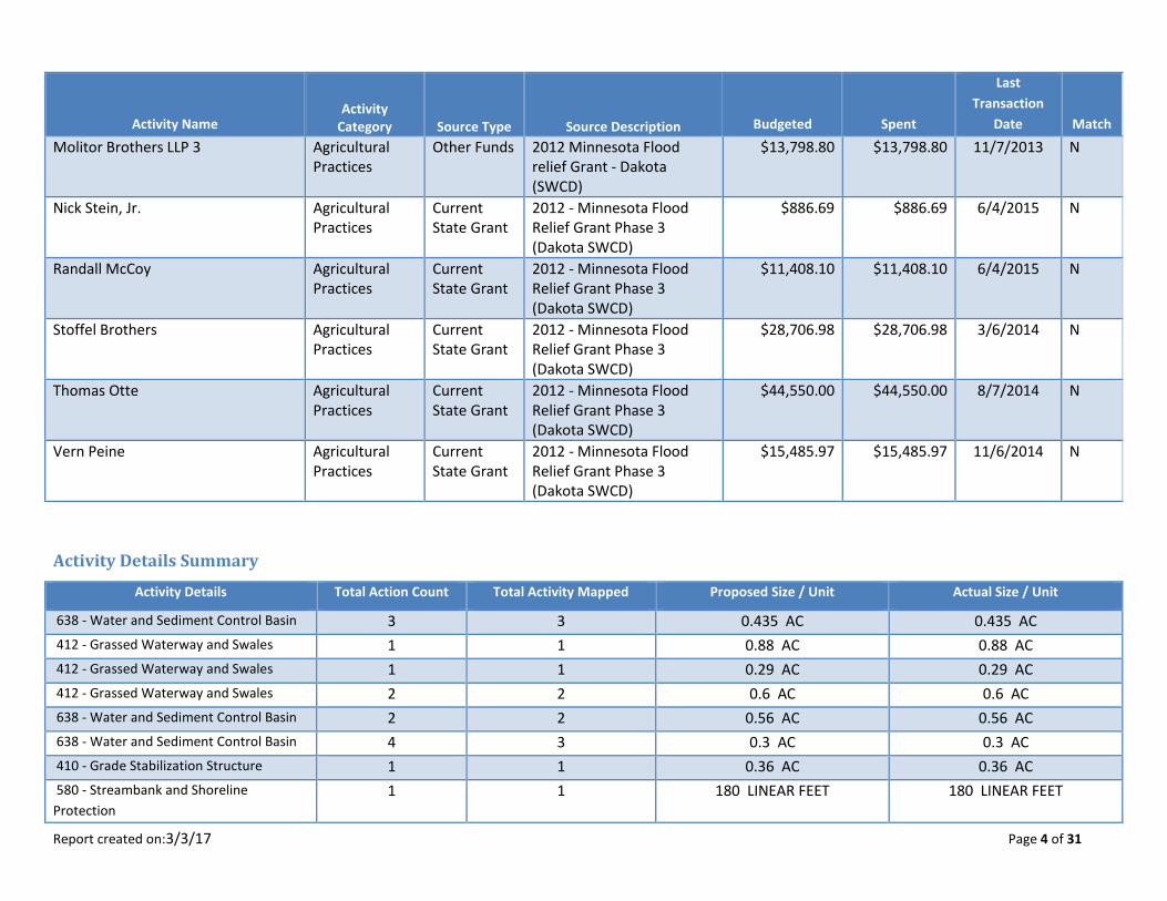
Molitor Brothers LLP Agricultural Practices
Current State Grant
2012 - Minnesota Flood Relief Grant Phase 3 (Dakota SWCD)
$49,950.00 $49,950.00 6/26/2014 N
Molitor Brothers LLP 2 (Charlie) Agricultural Practices
Current State Grant
2012 - Minnesota Flood Relief Grant Phase 3 (Dakota SWCD)
$5,836.21 $5,836.21 11/6/2014 N
Molitor Brothers LLP 2 (Charlie) Agricultural Practices
Other Funds 2012 minnesota flood relief grant - dakota (swcd)
$17,100.00 $6,788.88 6/26/2014 N
Molitor Brothers LLP 2 (Charlie) Agricultural Practices
Other Funds 2012 minnesota flood relief grant - dakota (swcd)
$17,100.00 $10,311.12 6/26/2014 N
Molitor Brothers LLP 3 Agricultural Practices
Current State Grant
2012 - Minnesota Flood Relief Grant Phase 3 (Dakota SWCD)
$7,256.42 $7,256.42 1/7/2016 N
Report created on:3/3/17 Page 4 of 31
Activity Name Activity
Category Source Type Source Description Budgeted Spent
Last
Transaction
Date Match
Molitor Brothers LLP 3 Agricultural Practices
Other Funds 2012 Minnesota Flood relief Grant - Dakota (SWCD)
$13,798.80 $13,798.80 11/7/2013 N
Nick Stein, Jr. Agricultural Practices
Current State Grant
2012 - Minnesota Flood Relief Grant Phase 3 (Dakota SWCD)
$886.69 $886.69 6/4/2015 N
Randall McCoy Agricultural Practices
Current State Grant
2012 - Minnesota Flood Relief Grant Phase 3 (Dakota SWCD)
$11,408.10 $11,408.10 6/4/2015 N
Stoffel Brothers Agricultural Practices
Current State Grant
2012 - Minnesota Flood Relief Grant Phase 3 (Dakota SWCD)
$28,706.98 $28,706.98 3/6/2014 N
Thomas Otte Agricultural Practices
Current State Grant
2012 - Minnesota Flood Relief Grant Phase 3 (Dakota SWCD)
$44,550.00 $44,550.00 8/7/2014 N
Vern Peine Agricultural Practices
Current State Grant
2012 - Minnesota Flood Relief Grant Phase 3 (Dakota SWCD)
$15,485.97 $15,485.97 11/6/2014 N
Activity Details Summary
Activity Details Total Action Count Total Activity Mapped Proposed Size / Unit Actual Size / Unit
638 - Water and Sediment Control Basin 3 3 0.435 AC 0.435 AC
412 - Grassed Waterway and Swales 1 1 0.88 AC 0.88 AC
412 - Grassed Waterway and Swales 1 1 0.29 AC 0.29 AC
412 - Grassed Waterway and Swales 2 2 0.6 AC 0.6 AC
638 - Water and Sediment Control Basin 2 2 0.56 AC 0.56 AC
638 - Water and Sediment Control Basin 4 3 0.3 AC 0.3 AC
410 - Grade Stabilization Structure 1 1 0.36 AC 0.36 AC
580 - Streambank and Shoreline
Protection
1 1 180 LINEAR FEET 180 LINEAR FEET
Report created on:3/3/17 Page 5 of 31
Activity Details Total Action Count Total Activity Mapped Proposed Size / Unit Actual Size / Unit
412 - Grassed Waterway and Swales 1 1 1.43 AC 1.43 AC
410 - Grade Stabilization Structure 1 1 1.25 AC 1.95 AC
412 - Grassed Waterway and Swales 2 2 1.85 AC 1.64 AC
378 - Pond for Water Use 1 1 0.36 AC 0.36 AC
638 - Water and Sediment Control Basin 1 1 0.1 AC 0.1 AC
342 - Critical Area Planting 1 1 10.3 AC 10.3 AC
638 - Water and Sediment Control Basin 1 1 0.28 AC 0.28 AC
638 - Water and Sediment Control Basin 2 2 0.4 AC 0.4 AC
412 - Grassed Waterway and Swales 1 1 2.2 AC 2.2 AC
638 - Water and Sediment Control Basin 3 3 0.6 AC 0.6 AC
412 - Grassed Waterway and Swales 7 7 2.82 AC 2.82 AC
638 - Water and Sediment Control Basin 2 2 0.7 AC 0.7 AC
638 - Water and Sediment Control Basin 3 3 3.58 AC 3.58 AC
638 - Water and Sediment Control Basin 5 5 3.06 AC 3.06 AC
412 - Grassed Waterway and Swales 3 3 0.11 AC 0.11 AC
Proposed Activity Indicators
Activity Name Indicator Name Value & Units Waterbody Calculation Tool Comments
Final Indicators Summary
Indicator Name Total Value Unit
SEDIMENT (TSS) 3,060.06 TONS/YR
PHOSPHORUS (EST. REDUCTION) 2,741.52 LBS/YR
SOIL (EST. SAVINGS) 3,939.17 TONS/YR

Report created on:3/3/17 Page 6 of 31
Grant Activity
Grant Activity - 2012 FRG Phase 3 Landowner Funds
Description 2012 FRG Phase 3 Landowner Funds
Category AGRICULTURAL PRACTICES
Start Date 31-Jul-13 End Date 31-Dec-16
Has Rates and Hours? No
Actual Results Landowners contributed funds for 18 of the 25 contracts in this grant.
Grant Activity - 2012 FRG Phase3 EQIP Funds
Description 2012 FRG Phase 3 EQIP Funds
Category AGRICULTURAL PRACTICES
Start Date 31-Jul-13 End Date 31-Dec-16
Has Rates and Hours? No
Actual Results USDA funds have been combined with the flood relief grant funds for 8 of the 25 contracts in this grant.
Grant Activity - 2012 Flood Relief Grant Phase 3 Technical Assistance
Description 2012 Flood Relief Grant Phase 3 Technical Assistance
Category TECHNICAL/ENGINEERING ASSISTANCE
Start Date 31-Jul-13 End Date 31-Dec-16
Has Rates and Hours? No
Actual Results Projects with 25 landowners have been complete with this grant. Technical engineering assistance has been recognized at
20% for each of the project cost-share payments.
Report created on:3/3/17 Page 7 of 31
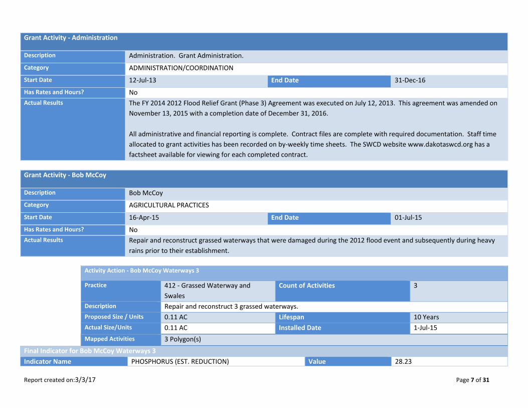
Grant Activity - Administration
Description Administration. Grant Administration.
Category ADMINISTRATION/COORDINATION
Start Date 12-Jul-13 End Date 31-Dec-16
Has Rates and Hours? No
Actual Results The FY 2014 2012 Flood Relief Grant (Phase 3) Agreement was executed on July 12, 2013. This agreement was amended on
November 13, 2015 with a completion date of December 31, 2016.
All administrative and financial reporting is complete. Contract files are complete with required documentation. Staff time
allocated to grant activities has been recorded on by-weekly time sheets. The SWCD website www.dakotaswcd.org has a
factsheet available for viewing for each completed contract.
Grant Activity - Bob McCoy
Description Bob McCoy
Category AGRICULTURAL PRACTICES
Start Date 16-Apr-15 End Date 01-Jul-15
Has Rates and Hours? No
Actual Results Repair and reconstruct grassed waterways that were damaged during the 2012 flood event and subsequently during heavy
rains prior to their establishment.
Activity Action - Bob McCoy Waterways 3
Practice 412 - Grassed Waterway and
Swales
Count of Activities 3
Description Repair and reconstruct 3 grassed waterways.
Proposed Size / Units 0.11 AC Lifespan 10 Years
Actual Size/Units 0.11 AC Installed Date 1-Jul-15
Mapped Activities 3 Polygon(s)
Final Indicator for Bob McCoy Waterways 3
Indicator Name PHOSPHORUS (EST. REDUCTION) Value 28.23
Report created on:3/3/17 Page 8 of 31
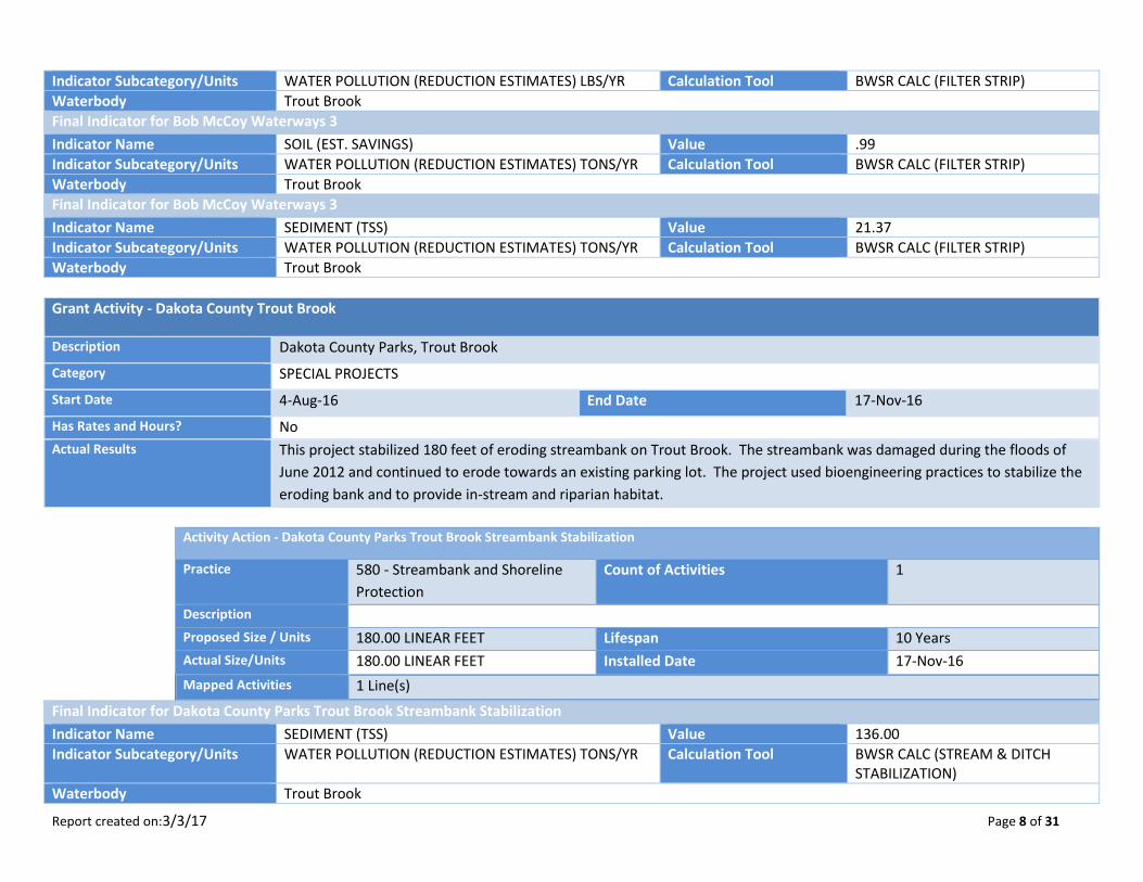
Indicator Subcategory/Units WATER POLLUTION (REDUCTION ESTIMATES) LBS/YR Calculation Tool BWSR CALC (FILTER STRIP)
Waterbody Trout Brook
Final Indicator for Bob McCoy Waterways 3
Indicator Name SOIL (EST. SAVINGS) Value .99
Indicator Subcategory/Units WATER POLLUTION (REDUCTION ESTIMATES) TONS/YR Calculation Tool BWSR CALC (FILTER STRIP)
Waterbody Trout Brook
Final Indicator for Bob McCoy Waterways 3
Indicator Name SEDIMENT (TSS) Value 21.37
Indicator Subcategory/Units WATER POLLUTION (REDUCTION ESTIMATES) TONS/YR Calculation Tool BWSR CALC (FILTER STRIP)
Waterbody Trout Brook
Grant Activity - Dakota County Trout Brook
Description Dakota County Parks, Trout Brook
Category SPECIAL PROJECTS
Start Date 4-Aug-16 End Date 17-Nov-16
Has Rates and Hours? No
Actual Results This project stabilized 180 feet of eroding streambank on Trout Brook. The streambank was damaged during the floods of
June 2012 and continued to erode towards an existing parking lot. The project used bioengineering practices to stabilize the
eroding bank and to provide in-stream and riparian habitat.
Activity Action - Dakota County Parks Trout Brook Streambank Stabilization
Practice 580 - Streambank and Shoreline
Protection
Count of Activities 1
Description
Proposed Size / Units 180.00 LINEAR FEET Lifespan 10 Years
Actual Size/Units 180.00 LINEAR FEET Installed Date 17-Nov-16
Mapped Activities 1 Line(s)
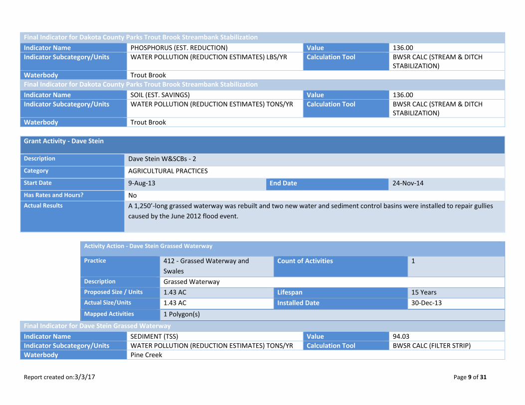
Final Indicator for Dakota County Parks Trout Brook Streambank Stabilization
Indicator Name SEDIMENT (TSS) Value 136.00
Indicator Subcategory/Units WATER POLLUTION (REDUCTION ESTIMATES) TONS/YR Calculation Tool BWSR CALC (STREAM & DITCH STABILIZATION)
Waterbody Trout Brook
Report created on:3/3/17 Page 9 of 31
Final Indicator for Dakota County Parks Trout Brook Streambank Stabilization
Indicator Name PHOSPHORUS (EST. REDUCTION) Value 136.00
Indicator Subcategory/Units WATER POLLUTION (REDUCTION ESTIMATES) LBS/YR Calculation Tool BWSR CALC (STREAM & DITCH STABILIZATION)
Waterbody Trout Brook
Final Indicator for Dakota County Parks Trout Brook Streambank Stabilization
Indicator Name SOIL (EST. SAVINGS) Value 136.00
Indicator Subcategory/Units WATER POLLUTION (REDUCTION ESTIMATES) TONS/YR Calculation Tool BWSR CALC (STREAM & DITCH STABILIZATION)
Waterbody Trout Brook
Grant Activity - Dave Stein
Description Dave Stein W&SCBs - 2
Category AGRICULTURAL PRACTICES
Start Date 9-Aug-13 End Date 24-Nov-14
Has Rates and Hours? No
Actual Results A 1,250’-long grassed waterway was rebuilt and two new water and sediment control basins were installed to repair gullies
caused by the June 2012 flood event.
Activity Action - Dave Stein Grassed Waterway
Practice 412 - Grassed Waterway and
Swales
Count of Activities 1
Description Grassed Waterway
Proposed Size / Units 1.43 AC Lifespan 15 Years
Actual Size/Units 1.43 AC Installed Date 30-Dec-13
Mapped Activities 1 Polygon(s)
Final Indicator for Dave Stein Grassed Waterway
Indicator Name SEDIMENT (TSS) Value 94.03
Indicator Subcategory/Units WATER POLLUTION (REDUCTION ESTIMATES) TONS/YR Calculation Tool BWSR CALC (FILTER STRIP)
Waterbody Pine Creek
Report created on:3/3/17 Page 10 of 31
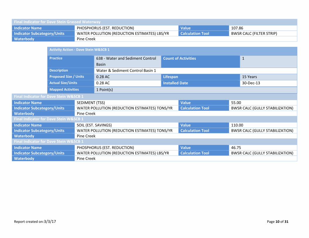
Final Indicator for Dave Stein Grassed Waterway
Indicator Name PHOSPHORUS (EST. REDUCTION) Value 107.86
Indicator Subcategory/Units WATER POLLUTION (REDUCTION ESTIMATES) LBS/YR Calculation Tool BWSR CALC (FILTER STRIP)
Waterbody Pine Creek
Activity Action - Dave Stein W&SCB 1
Practice 638 - Water and Sediment Control
Basin
Count of Activities 1
Description Water & Sediment Control Basin 1
Proposed Size / Units 0.28 AC Lifespan 15 Years
Actual Size/Units 0.28 AC Installed Date 30-Dec-13
Mapped Activities 1 Point(s)
Final Indicator for Dave Stein W&SCB 1
Indicator Name SEDIMENT (TSS) Value 55.00
Indicator Subcategory/Units WATER POLLUTION (REDUCTION ESTIMATES) TONS/YR Calculation Tool BWSR CALC (GULLY STABILIZATION)
Waterbody Pine Creek
Final Indicator for Dave Stein W&SCB 1
Indicator Name SOIL (EST. SAVINGS) Value 110.00
Indicator Subcategory/Units WATER POLLUTION (REDUCTION ESTIMATES) TONS/YR Calculation Tool BWSR CALC (GULLY STABILIZATION)
Waterbody Pine Creek
Final Indicator for Dave Stein W&SCB 1
Indicator Name PHOSPHORUS (EST. REDUCTION) Value 46.75
Indicator Subcategory/Units WATER POLLUTION (REDUCTION ESTIMATES) LBS/YR Calculation Tool BWSR CALC (GULLY STABILIZATION)
Waterbody Pine Creek
Report created on:3/3/17 Page 11 of 31
Activity Action - Dave Stein W&SCB 2
Practice 638 - Water and Sediment Control
Basin
Count of Activities 1
Description Water & Sediment Control Basin 2
Proposed Size / Units 0.30 AC Lifespan 15 Years
Actual Size/Units 0.30 AC Installed Date 30-Dec-13
Mapped Activities 1 Point(s)
Final Indicator for Dave Stein W&SCB 2
Indicator Name SEDIMENT (TSS) Value .77
Indicator Subcategory/Units WATER POLLUTION (REDUCTION ESTIMATES) TONS/YR Calculation Tool BWSR CALC (SHEET AND RILL)
Waterbody Pine Creek
Final Indicator for Dave Stein W&SCB 2
Indicator Name PHOSPHORUS (EST. REDUCTION) Value 1.20
Indicator Subcategory/Units WATER POLLUTION (REDUCTION ESTIMATES) LBS/YR Calculation Tool BWSR CALC (SHEET AND RILL)
Waterbody Pine Creek
Final Indicator for Dave Stein W&SCB 2
Indicator Name SOIL (EST. SAVINGS) Value 8.36
Indicator Subcategory/Units WATER POLLUTION (REDUCTION ESTIMATES) TONS/YR Calculation Tool BWSR CALC (SHEET AND RILL)
Waterbody Pine Creek
Grant Activity - David Cook
Description David Cook
Category AGRICULTURAL PRACTICES
Start Date 8-Aug-14 End Date 24-Aug-15
Has Rates and Hours? No
Actual Results Reconstruct a 425-foot long grassed waterway with clean fill material, straw mulch, and seeding to fix gully caused by during
the 2012 flood event.
Report created on:3/3/17 Page 12 of 31
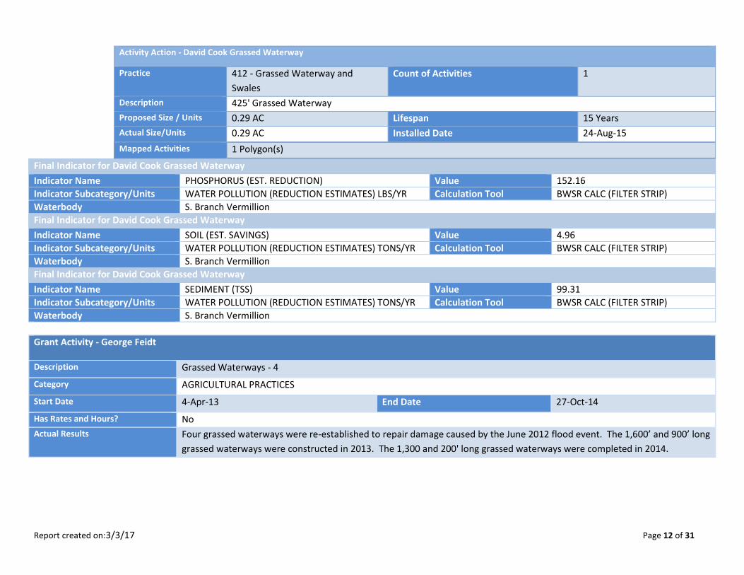
Activity Action - David Cook Grassed Waterway
Practice 412 - Grassed Waterway and
Swales
Count of Activities 1
Description 425' Grassed Waterway
Proposed Size / Units 0.29 AC Lifespan 15 Years
Actual Size/Units 0.29 AC Installed Date 24-Aug-15
Mapped Activities 1 Polygon(s)
Final Indicator for David Cook Grassed Waterway
Indicator Name PHOSPHORUS (EST. REDUCTION) Value 152.16
Indicator Subcategory/Units WATER POLLUTION (REDUCTION ESTIMATES) LBS/YR Calculation Tool BWSR CALC (FILTER STRIP)
Waterbody S. Branch Vermillion
Final Indicator for David Cook Grassed Waterway
Indicator Name SOIL (EST. SAVINGS) Value 4.96
Indicator Subcategory/Units WATER POLLUTION (REDUCTION ESTIMATES) TONS/YR Calculation Tool BWSR CALC (FILTER STRIP)
Waterbody S. Branch Vermillion
Final Indicator for David Cook Grassed Waterway
Indicator Name SEDIMENT (TSS) Value 99.31
Indicator Subcategory/Units WATER POLLUTION (REDUCTION ESTIMATES) TONS/YR Calculation Tool BWSR CALC (FILTER STRIP)
Waterbody S. Branch Vermillion
Grant Activity - George Feidt
Description Grassed Waterways - 4
Category AGRICULTURAL PRACTICES
Start Date 4-Apr-13 End Date 27-Oct-14
Has Rates and Hours? No
Actual Results Four grassed waterways were re-established to repair damage caused by the June 2012 flood event. The 1,600’ and 900’ long
grassed waterways were constructed in 2013. The 1,300 and 200' long grassed waterways were completed in 2014.
Report created on:3/3/17 Page 13 of 31
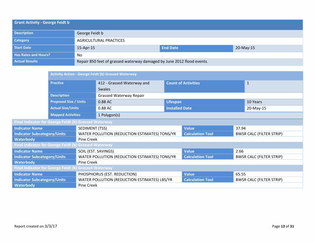
Grant Activity - George Feidt b
Description George Feidt b
Category AGRICULTURAL PRACTICES
Start Date 15-Apr-15 End Date 20-May-15
Has Rates and Hours? No
Actual Results Repair 850 feet of grassed waterway damaged by June 2012 flood events.
Activity Action - George Feidt (b) Grassed Waterway
Practice 412 - Grassed Waterway and
Swales
Count of Activities 1
Description Grassed Waterway Repair
Proposed Size / Units 0.88 AC Lifespan 10 Years
Actual Size/Units 0.88 AC Installed Date 20-May-15
Mapped Activities 1 Polygon(s)
Final Indicator for George Feidt (b) Grassed Waterway
Indicator Name SEDIMENT (TSS) Value 37.94
Indicator Subcategory/Units WATER POLLUTION (REDUCTION ESTIMATES) TONS/YR Calculation Tool BWSR CALC (FILTER STRIP)
Waterbody Pine Creek
Final Indicator for George Feidt (b) Grassed Waterway
Indicator Name SOIL (EST. SAVINGS) Value 2.66
Indicator Subcategory/Units WATER POLLUTION (REDUCTION ESTIMATES) TONS/YR Calculation Tool BWSR CALC (FILTER STRIP)
Waterbody Pine Creek
Final Indicator for George Feidt (b) Grassed Waterway
Indicator Name PHOSPHORUS (EST. REDUCTION) Value 65.55
Indicator Subcategory/Units WATER POLLUTION (REDUCTION ESTIMATES) LBS/YR Calculation Tool BWSR CALC (FILTER STRIP)
Waterbody Pine Creek
Report created on:3/3/17 Page 14 of 31
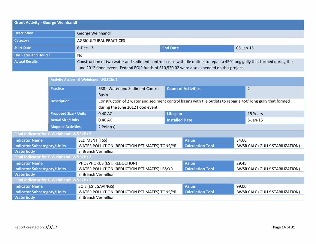
Grant Activity - George Weinhandl
Description George Weinhandl
Category AGRICULTURAL PRACTICES
Start Date 6-Dec-13 End Date 05-Jan-15
Has Rates and Hours? No
Actual Results Construction of two water and sediment control basins with tile outlets to repair a 450' long gully that formed during the
June 2012 flood event. Federal EQIP funds of $10,520.02 were also expended on this project.
Activity Action - G Weinhandl W&SCBs 2
Practice 638 - Water and Sediment Control
Basin
Count of Activities 2
Description Construction of 2 water and sediment control basins with tile outlets to repair a 450' long gully that formed
during the June 2012 flood event.
Proposed Size / Units 0.40 AC Lifespan 15 Years
Actual Size/Units 0.40 AC Installed Date 5-Jan-15
Mapped Activities 2 Point(s)
Final Indicator for G Weinhandl W&SCBs 2
Indicator Name SEDIMENT (TSS) Value 34.66
Indicator Subcategory/Units WATER POLLUTION (REDUCTION ESTIMATES) TONS/YR Calculation Tool BWSR CALC (GULLY STABILIZATION)
Waterbody S. Branch Vermillion
Final Indicator for G Weinhandl W&SCBs 2
Indicator Name PHOSPHORUS (EST. REDUCTION) Value 29.45
Indicator Subcategory/Units WATER POLLUTION (REDUCTION ESTIMATES) LBS/YR Calculation Tool BWSR CALC (GULLY STABILIZATION)
Waterbody S. Branch Vermillion
Final Indicator for G Weinhandl W&SCBs 2
Indicator Name SOIL (EST. SAVINGS) Value 99.00
Indicator Subcategory/Units WATER POLLUTION (REDUCTION ESTIMATES) TONS/YR Calculation Tool BWSR CALC (GULLY STABILIZATION)
Waterbody S. Branch Vermillion
Report created on:3/3/17 Page 15 of 31
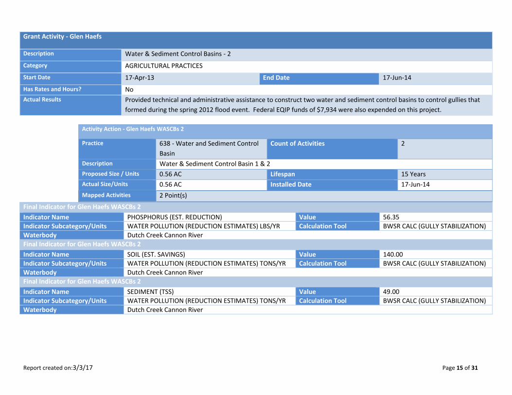
Grant Activity - Glen Haefs
Description Water & Sediment Control Basins - 2
Category AGRICULTURAL PRACTICES
Start Date 17-Apr-13 End Date 17-Jun-14
Has Rates and Hours? No
Actual Results Provided technical and administrative assistance to construct two water and sediment control basins to control gullies that
formed during the spring 2012 flood event. Federal EQIP funds of $7,934 were also expended on this project.
Activity Action - Glen Haefs WASCBs 2
Practice 638 - Water and Sediment Control
Basin
Count of Activities 2
Description Water & Sediment Control Basin 1 & 2
Proposed Size / Units 0.56 AC Lifespan 15 Years
Actual Size/Units 0.56 AC Installed Date 17-Jun-14
Mapped Activities 2 Point(s)
Final Indicator for Glen Haefs WASCBs 2
Indicator Name PHOSPHORUS (EST. REDUCTION) Value 56.35
Indicator Subcategory/Units WATER POLLUTION (REDUCTION ESTIMATES) LBS/YR Calculation Tool BWSR CALC (GULLY STABILIZATION)
Waterbody Dutch Creek Cannon River
Final Indicator for Glen Haefs WASCBs 2
Indicator Name SOIL (EST. SAVINGS) Value 140.00
Indicator Subcategory/Units WATER POLLUTION (REDUCTION ESTIMATES) TONS/YR Calculation Tool BWSR CALC (GULLY STABILIZATION)
Waterbody Dutch Creek Cannon River
Final Indicator for Glen Haefs WASCBs 2
Indicator Name SEDIMENT (TSS) Value 49.00
Indicator Subcategory/Units WATER POLLUTION (REDUCTION ESTIMATES) TONS/YR Calculation Tool BWSR CALC (GULLY STABILIZATION)
Waterbody Dutch Creek Cannon River
Report created on:3/3/17 Page 16 of 31
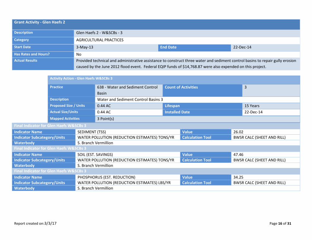
Grant Activity - Glen Haefs 2
Description Glen Haefs 2 - W&SCBs - 3
Category AGRICULTURAL PRACTICES
Start Date 3-May-13 End Date 22-Dec-14
Has Rates and Hours? No
Actual Results Provided technical and administrative assistance to construct three water and sediment control basins to repair gully erosion
caused by the June 2012 flood event. Federal EQIP funds of $14,768.87 were also expended on this project.
Activity Action - Glen Haefs W&SCBs 3
Practice 638 - Water and Sediment Control
Basin
Count of Activities 3
Description Water and Sediment Control Basins 3
Proposed Size / Units 0.44 AC Lifespan 15 Years
Actual Size/Units 0.44 AC Installed Date 22-Dec-14
Mapped Activities 3 Point(s)
Final Indicator for Glen Haefs W&SCBs 3
Indicator Name SEDIMENT (TSS) Value 26.02
Indicator Subcategory/Units WATER POLLUTION (REDUCTION ESTIMATES) TONS/YR Calculation Tool BWSR CALC (SHEET AND RILL)
Waterbody S. Branch Vermillion
Final Indicator for Glen Haefs W&SCBs 3
Indicator Name SOIL (EST. SAVINGS) Value 47.46
Indicator Subcategory/Units WATER POLLUTION (REDUCTION ESTIMATES) TONS/YR Calculation Tool BWSR CALC (SHEET AND RILL)
Waterbody S. Branch Vermillion
Final Indicator for Glen Haefs W&SCBs 3
Indicator Name PHOSPHORUS (EST. REDUCTION) Value 34.25
Indicator Subcategory/Units WATER POLLUTION (REDUCTION ESTIMATES) LBS/YR Calculation Tool BWSR CALC (SHEET AND RILL)
Waterbody S. Branch Vermillion
Report created on:3/3/17 Page 17 of 31
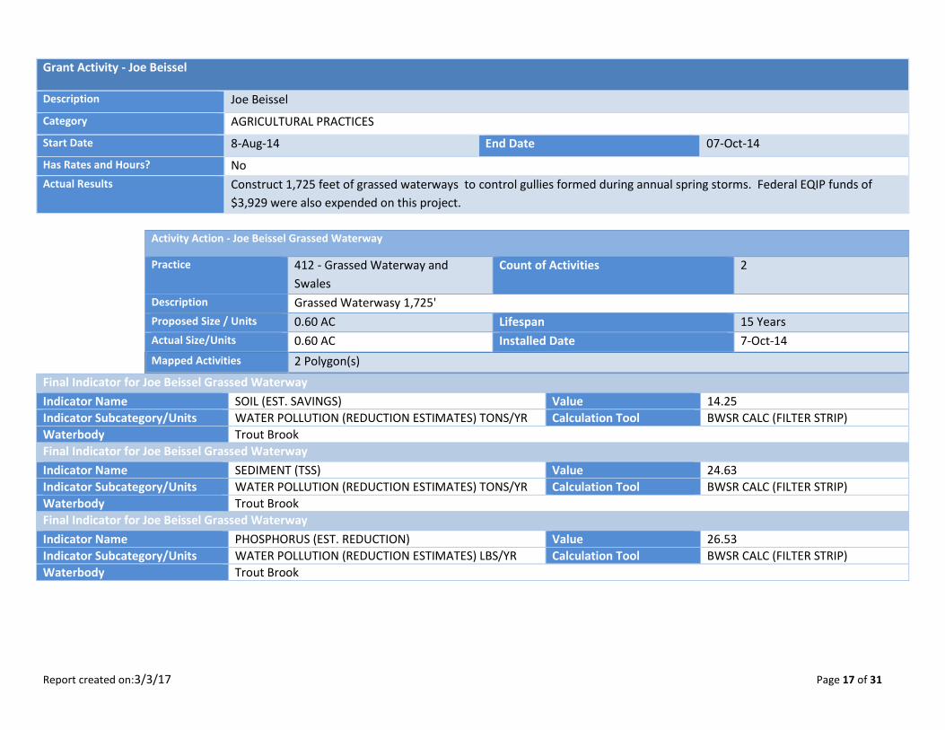
Grant Activity - Joe Beissel
Description Joe Beissel
Category AGRICULTURAL PRACTICES
Start Date 8-Aug-14 End Date 07-Oct-14
Has Rates and Hours? No
Actual Results Construct 1,725 feet of grassed waterways to control gullies formed during annual spring storms. Federal EQIP funds of
$3,929 were also expended on this project.
Activity Action - Joe Beissel Grassed Waterway
Practice 412 - Grassed Waterway and
Swales
Count of Activities 2
Description Grassed Waterwasy 1,725'
Proposed Size / Units 0.60 AC Lifespan 15 Years
Actual Size/Units 0.60 AC Installed Date 7-Oct-14
Mapped Activities 2 Polygon(s)
Final Indicator for Joe Beissel Grassed Waterway
Indicator Name SOIL (EST. SAVINGS) Value 14.25
Indicator Subcategory/Units WATER POLLUTION (REDUCTION ESTIMATES) TONS/YR Calculation Tool BWSR CALC (FILTER STRIP)
Waterbody Trout Brook
Final Indicator for Joe Beissel Grassed Waterway
Indicator Name SEDIMENT (TSS) Value 24.63
Indicator Subcategory/Units WATER POLLUTION (REDUCTION ESTIMATES) TONS/YR Calculation Tool BWSR CALC (FILTER STRIP)
Waterbody Trout Brook
Final Indicator for Joe Beissel Grassed Waterway
Indicator Name PHOSPHORUS (EST. REDUCTION) Value 26.53
Indicator Subcategory/Units WATER POLLUTION (REDUCTION ESTIMATES) LBS/YR Calculation Tool BWSR CALC (FILTER STRIP)
Waterbody Trout Brook
Report created on:3/3/17 Page 18 of 31
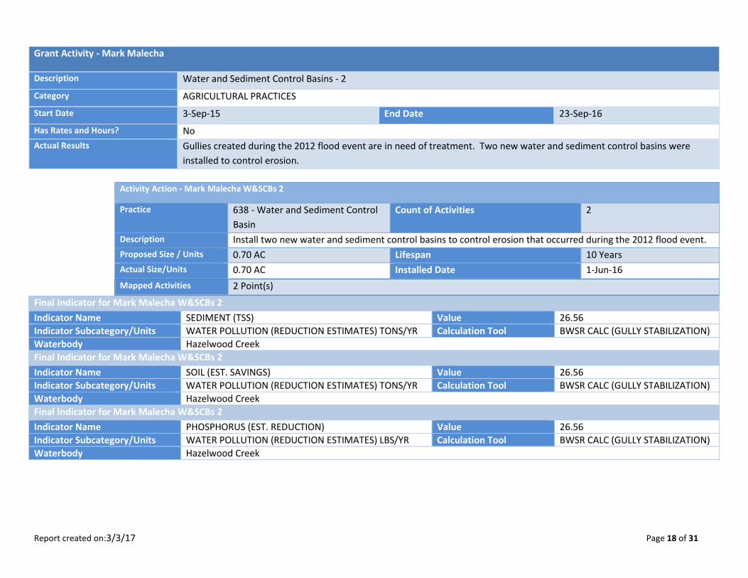
Grant Activity - Mark Malecha
Description Water and Sediment Control Basins - 2
Category AGRICULTURAL PRACTICES
Start Date 3-Sep-15 End Date 23-Sep-16
Has Rates and Hours? No
Actual Results Gullies created during the 2012 flood event are in need of treatment. Two new water and sediment control basins were
installed to control erosion.
Activity Action - Mark Malecha W&SCBs 2
Practice 638 - Water and Sediment Control
Basin
Count of Activities 2
Description Install two new water and sediment control basins to control erosion that occurred during the 2012 flood event.
Proposed Size / Units 0.70 AC Lifespan 10 Years
Actual Size/Units 0.70 AC Installed Date 1-Jun-16
Mapped Activities 2 Point(s)
Final Indicator for Mark Malecha W&SCBs 2
Indicator Name SEDIMENT (TSS) Value 26.56
Indicator Subcategory/Units WATER POLLUTION (REDUCTION ESTIMATES) TONS/YR Calculation Tool BWSR CALC (GULLY STABILIZATION)
Waterbody Hazelwood Creek
Final Indicator for Mark Malecha W&SCBs 2
Indicator Name SOIL (EST. SAVINGS) Value 26.56
Indicator Subcategory/Units WATER POLLUTION (REDUCTION ESTIMATES) TONS/YR Calculation Tool BWSR CALC (GULLY STABILIZATION)
Waterbody Hazelwood Creek
Final Indicator for Mark Malecha W&SCBs 2
Indicator Name PHOSPHORUS (EST. REDUCTION) Value 26.56
Indicator Subcategory/Units WATER POLLUTION (REDUCTION ESTIMATES) LBS/YR Calculation Tool BWSR CALC (GULLY STABILIZATION)
Waterbody Hazelwood Creek

Report created on:3/3/17 Page 19 of 31
Grant Activity - Marlys Weber
Description Marlys Weber
Category AGRICULTURAL PRACTICES
Start Date 5-Jun-15 End Date 25-Aug-15
Has Rates and Hours? No
Actual Results Install a new grade stabilization structure and repair existing embankment pond damaged by the 2012 flood events.
Activity Action - Maryls Weber Pond
Practice 378 - Pond for Water Use Count of Activities 1
Description Repair of pond embankment.
Proposed Size / Units 0.36 AC Lifespan 10 Years
Actual Size/Units 0.36 AC Installed Date 25-Aug-15
Mapped Activities 1 Point(s)
Final Indicator for Maryls Weber Pond
Indicator Name PHOSPHORUS (EST. REDUCTION) Value 164.73
Indicator Subcategory/Units WATER POLLUTION (REDUCTION ESTIMATES) LBS/YR Calculation Tool BWSR CALC (GULLY STABILIZATION)
Waterbody Trout Brook
Final Indicator for Maryls Weber Pond
Indicator Name SOIL (EST. SAVINGS) Value 164.73
Indicator Subcategory/Units WATER POLLUTION (REDUCTION ESTIMATES) TONS/YR Calculation Tool BWSR CALC (GULLY STABILIZATION)
Waterbody Trout Brook
Final Indicator for Maryls Weber Pond
Indicator Name SEDIMENT (TSS) Value 164.73
Indicator Subcategory/Units WATER POLLUTION (REDUCTION ESTIMATES) TONS/YR Calculation Tool BWSR CALC (GULLY STABILIZATION)
Waterbody Trout Brook
Report created on:3/3/17 Page 20 of 31
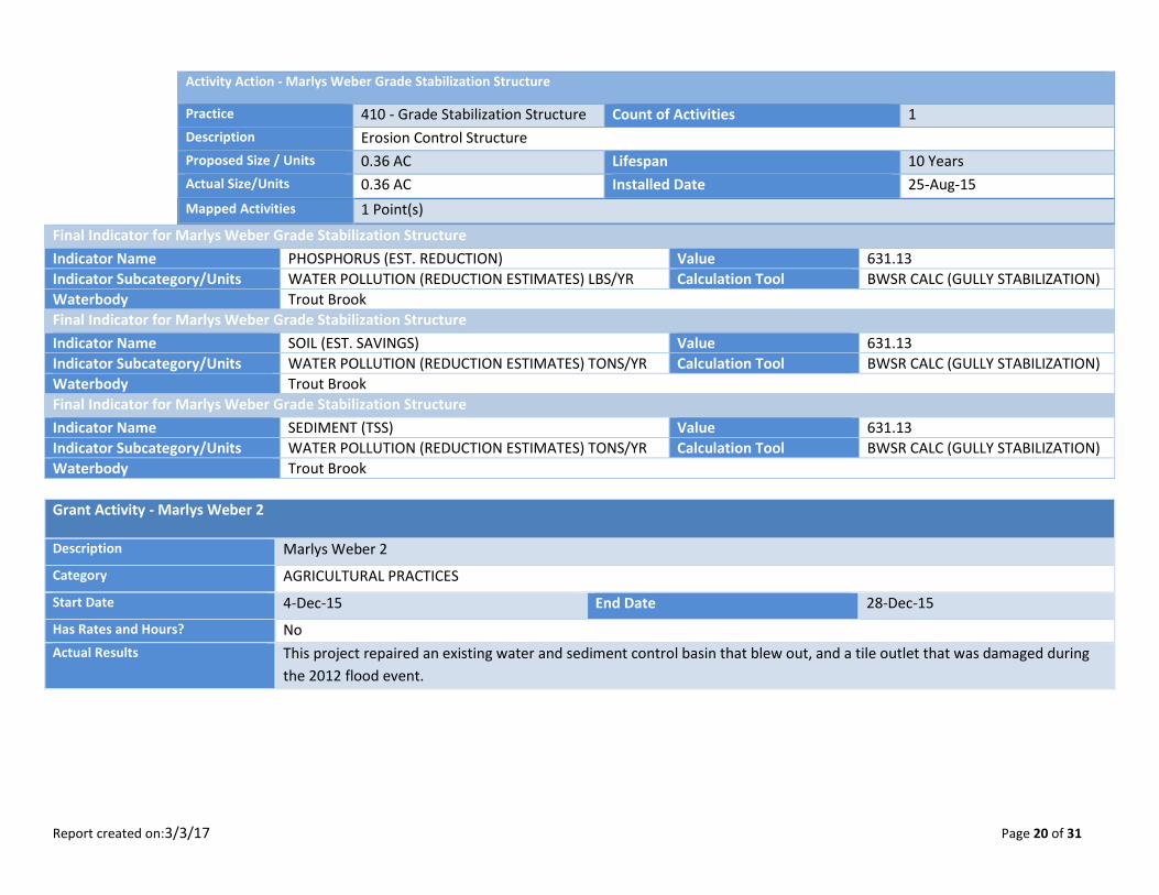
Activity Action - Marlys Weber Grade Stabilization Structure
Practice 410 - Grade Stabilization Structure Count of Activities 1
Description Erosion Control Structure
Proposed Size / Units 0.36 AC Lifespan 10 Years
Actual Size/Units 0.36 AC Installed Date 25-Aug-15
Mapped Activities 1 Point(s)
Final Indicator for Marlys Weber Grade Stabilization Structure
Indicator Name PHOSPHORUS (EST. REDUCTION) Value 631.13
Indicator Subcategory/Units WATER POLLUTION (REDUCTION ESTIMATES) LBS/YR Calculation Tool BWSR CALC (GULLY STABILIZATION)
Waterbody Trout Brook
Final Indicator for Marlys Weber Grade Stabilization Structure
Indicator Name SOIL (EST. SAVINGS) Value 631.13
Indicator Subcategory/Units WATER POLLUTION (REDUCTION ESTIMATES) TONS/YR Calculation Tool BWSR CALC (GULLY STABILIZATION)
Waterbody Trout Brook
Final Indicator for Marlys Weber Grade Stabilization Structure
Indicator Name SEDIMENT (TSS) Value 631.13
Indicator Subcategory/Units WATER POLLUTION (REDUCTION ESTIMATES) TONS/YR Calculation Tool BWSR CALC (GULLY STABILIZATION)
Waterbody Trout Brook
Grant Activity - Marlys Weber 2
Description Marlys Weber 2
Category AGRICULTURAL PRACTICES
Start Date 4-Dec-15 End Date 28-Dec-15
Has Rates and Hours? No
Actual Results This project repaired an existing water and sediment control basin that blew out, and a tile outlet that was damaged during
the 2012 flood event.

Report created on:3/3/17 Page 21 of 31
Activity Action - Marlys Weber
Practice 638 - Water and Sediment Control
Basin
Count of Activities 1
Description Water and Sediment Control Basin
Proposed Size / Units 0.30 AC Lifespan 10 Years
Actual Size/Units 0.30 AC Installed Date 28-Dec-15
Mapped Activities 1 Point(s)
Final Indicator for Marlys Weber
Indicator Name SOIL (EST. SAVINGS) Value 51.00
Indicator Subcategory/Units WATER POLLUTION (REDUCTION ESTIMATES) TONS/YR Calculation Tool BWSR CALC (GULLY STABILIZATION)
Waterbody Trout Brook
Final Indicator for Marlys Weber
Indicator Name SEDIMENT (TSS) Value 51.00
Indicator Subcategory/Units WATER POLLUTION (REDUCTION ESTIMATES) TONS/YR Calculation Tool BWSR CALC (GULLY STABILIZATION)
Waterbody Trout Brook
Final Indicator for Marlys Weber
Indicator Name PHOSPHORUS (EST. REDUCTION) Value 51.00
Indicator Subcategory/Units WATER POLLUTION (REDUCTION ESTIMATES) LBS/YR Calculation Tool BWSR CALC (GULLY STABILIZATION)
Waterbody Trout Brook
Grant Activity - Maureen Fasbender
Description Maureen Fasbender
Category AGRICULTURAL PRACTICES
Start Date 3-Jul-15 End Date 26-Jun-15
Has Rates and Hours? No
Actual Results Two existing water and sediment control basins were damaged during the 2012 flood. Technical and administrative
assistance was provided to cleanout existing basins and install one new basin.
Report created on:3/3/17 Page 22 of 31
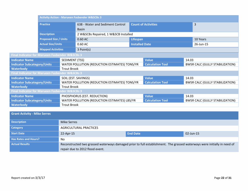
Activity Action - Marueen Fasbender W&SCBs 3
Practice 638 - Water and Sediment Control
Basin
Count of Activities 3
Description 2 W&SCBs Repaired, 1 W&SCB Installed
Proposed Size / Units 0.60 AC Lifespan 10 Years
Actual Size/Units 0.60 AC Installed Date 26-Jun-15
Mapped Activities 3 Point(s)
Final Indicator for Marueen Fasbender W&SCBs 3
Indicator Name SEDIMENT (TSS) Value 14.03
Indicator Subcategory/Units WATER POLLUTION (REDUCTION ESTIMATES) TONS/YR Calculation Tool BWSR CALC (GULLY STABILIZATION)
Waterbody Trout Brook
Final Indicator for Marueen Fasbender W&SCBs 3
Indicator Name SOIL (EST. SAVINGS) Value 14.03
Indicator Subcategory/Units WATER POLLUTION (REDUCTION ESTIMATES) TONS/YR Calculation Tool BWSR CALC (GULLY STABILIZATION)
Waterbody Trout Brook
Final Indicator for Marueen Fasbender W&SCBs 3
Indicator Name PHOSPHORUS (EST. REDUCTION) Value 14.03
Indicator Subcategory/Units WATER POLLUTION (REDUCTION ESTIMATES) LBS/YR Calculation Tool BWSR CALC (GULLY STABILIZATION)
Waterbody Trout Brook
Grant Activity - Mike Serres
Description Mike Serres
Category AGRICULTURAL PRACTICES
Start Date 22-Apr-15 End Date 02-Jun-15
Has Rates and Hours? No
Actual Results Reconstructed two grassed waterways damaged prior to full establishment. The grassed waterways were initially in need of
repair due to 2012 flood event.
Report created on:3/3/17 Page 23 of 31
Activity Action - Mike Serres Grassed Waterways - 2
Practice 412 - Grassed Waterway and
Swales
Count of Activities 2
Description Grassed Waterways - 2
Proposed Size / Units 1.85 AC Lifespan 10 Years
Actual Size/Units 1.64 AC Installed Date 2-Jun-15
Mapped Activities 2 Polygon(s)
Final Indicator for Mike Serres Grassed Waterways - 2
Indicator Name SEDIMENT (TSS) Value 351.30
Indicator Subcategory/Units WATER POLLUTION (REDUCTION ESTIMATES) TONS/YR Calculation Tool BWSR CALC (FILTER STRIP)
Waterbody Trout Brook
Final Indicator for Mike Serres Grassed Waterways - 2
Indicator Name PHOSPHORUS (EST. REDUCTION) Value 197.27
Indicator Subcategory/Units WATER POLLUTION (REDUCTION ESTIMATES) LBS/YR Calculation Tool BWSR CALC (FILTER STRIP)
Waterbody Trout Brook
Final Indicator for Mike Serres Grassed Waterways - 2
Indicator Name SOIL (EST. SAVINGS) Value 513.00
Indicator Subcategory/Units WATER POLLUTION (REDUCTION ESTIMATES) TONS/YR Calculation Tool BWSR CALC (FILTER STRIP)
Waterbody Trout Brook
Grant Activity - Molitor Brothers LLP
Description Molitor Brothers LLP - W&SCBs 5
Category AGRICULTURAL PRACTICES
Start Date 4-Apr-14 End Date 10-Jun-14
Has Rates and Hours? No
Actual Results Five water and sediment control basins were constructed to control gullies that formed during the 2012 flood event.
Report created on:3/3/17 Page 24 of 31
Activity Action - Molitor Brothers W&SCBs 5
Practice 638 - Water and Sediment Control
Basin
Count of Activities 5
Description 5 W&SCBs
Proposed Size / Units 3.06 AC Lifespan 15 Years
Actual Size/Units 3.06 AC Installed Date 10-Jun-14
Mapped Activities 5 Point(s)
Final Indicator for Molitor Brothers W&SCBs 5
Indicator Name PHOSPHORUS (EST. REDUCTION) Value 263.96
Indicator Subcategory/Units WATER POLLUTION (REDUCTION ESTIMATES) LBS/YR Calculation Tool BWSR CALC (SHEET AND RILL)
Waterbody Trout Brook
Final Indicator for Molitor Brothers W&SCBs 5
Indicator Name SEDIMENT (TSS) Value 349.04
Indicator Subcategory/Units WATER POLLUTION (REDUCTION ESTIMATES) TONS/YR Calculation Tool BWSR CALC (SHEET AND RILL)
Waterbody Trout Brook
Final Indicator for Molitor Brothers W&SCBs 5
Indicator Name SOIL (EST. SAVINGS) Value 297.73
Indicator Subcategory/Units WATER POLLUTION (REDUCTION ESTIMATES) TONS/YR Calculation Tool BWSR CALC (SHEET AND RILL)
Waterbody Trout Brook
Grant Activity - Molitor Brothers LLP 2 (Charlie)
Description Grassed Waterways - 5
Category AGRICULTURAL PRACTICES
Start Date 2-May-13 End Date 27-Oct-14
Has Rates and Hours? No
Actual Results Re-graded and reseed 2,300 feet of main waterway. Re-grade, reseed and install erosion control blanket on 700 feet of the
east waterway. Re-grade, reseed, and install erosion control blanket on 600 feet of southwest waterway. This project used
Phase I funds and then Phase III funds for the repair.
Report created on:3/3/17 Page 25 of 31
Grant Activity - Molitor Brothers LLP 3
Description Grassed Waterways - 6, Water and Sediment Control Basins - 1
Category AGRICULTURAL PRACTICES
Start Date 10-Jul-13 End Date 29-Oct-13
Has Rates and Hours? No
Actual Results 11/07/2013 - Board Approved Partial Payment for Completion of 6 Grassed Waterways ($13,798.80). 01/07/2016 - Board
Approved Final Payment for 1 W&SCB ($7,256.42).
Grant Activity - Nick Stein, Jr.
Description Nick Stein, Jr.
Category AGRICULTURAL PRACTICES
Start Date 7-Nov-14 End Date 29-May-15
Has Rates and Hours? No
Actual Results Repair water and sediment control basin damaged during the 2012 flood events.
Activity Action - Nick Stein W&SCB Repair
Practice 638 - Water and Sediment Control
Basin
Count of Activities 1
Description W&SCB Repair
Proposed Size / Units 0.10 AC Lifespan 15 Years
Actual Size/Units 0.10 AC Installed Date 29-May-15
Mapped Activities 1 Point(s)
Final Indicator for Nick Stein W&SCB Repair
Indicator Name SOIL (EST. SAVINGS) Value 154.06
Indicator Subcategory/Units WATER POLLUTION (REDUCTION ESTIMATES) TONS/YR Calculation Tool BWSR CALC (GULLY STABILIZATION)
Waterbody Pine Creek
Final Indicator for Nick Stein W&SCB Repair
Indicator Name SEDIMENT (TSS) Value 77.03
Indicator Subcategory/Units WATER POLLUTION (REDUCTION ESTIMATES) TONS/YR Calculation Tool BWSR CALC (GULLY STABILIZATION)
Waterbody Pine Creek
Report created on:3/3/17 Page 26 of 31
Final Indicator for Nick Stein W&SCB Repair
Indicator Name PHOSPHORUS (EST. REDUCTION) Value 77.03
Indicator Subcategory/Units WATER POLLUTION (REDUCTION ESTIMATES) LBS/YR Calculation Tool BWSR CALC (GULLY STABILIZATION)
Waterbody Pine Creek
Grant Activity - Randall McCoy
Description Randall McCoy
Category AGRICULTURAL PRACTICES
Start Date 4-Apr-14 End Date 01-Jun-15
Has Rates and Hours? No
Actual Results Repair 2,743 feet of grassed waterway and install two new water and sediment control basins as result of 2012 flood events.
Activity Action - Randall McCoy Grassed Waterway
Practice 412 - Grassed Waterway and
Swales
Count of Activities 1
Description Grassed Waterway Repair (2,743 feet)
Proposed Size / Units 2.20 AC Lifespan 15 Years
Actual Size/Units 2.20 AC Installed Date 1-Jun-15
Mapped Activities 1 Polygon(s)
Final Indicator for Randall McCoy Grassed Waterway
Indicator Name SOIL (EST. SAVINGS) Value 254.20
Indicator Subcategory/Units WATER POLLUTION (REDUCTION ESTIMATES) TONS/YR Calculation Tool BWSR CALC (FILTER STRIP)
Waterbody Cannon River
Final Indicator for Randall McCoy Grassed Waterway
Indicator Name PHOSPHORUS (EST. REDUCTION) Value 151.15
Indicator Subcategory/Units WATER POLLUTION (REDUCTION ESTIMATES) LBS/YR Calculation Tool BWSR CALC (FILTER STRIP)
Waterbody Cannon River
Final Indicator for Randall McCoy Grassed Waterway
Indicator Name SEDIMENT (TSS) Value 190.88
Indicator Subcategory/Units WATER POLLUTION (REDUCTION ESTIMATES) TONS/YR Calculation Tool BWSR CALC (FILTER STRIP)
Waterbody Cannon River
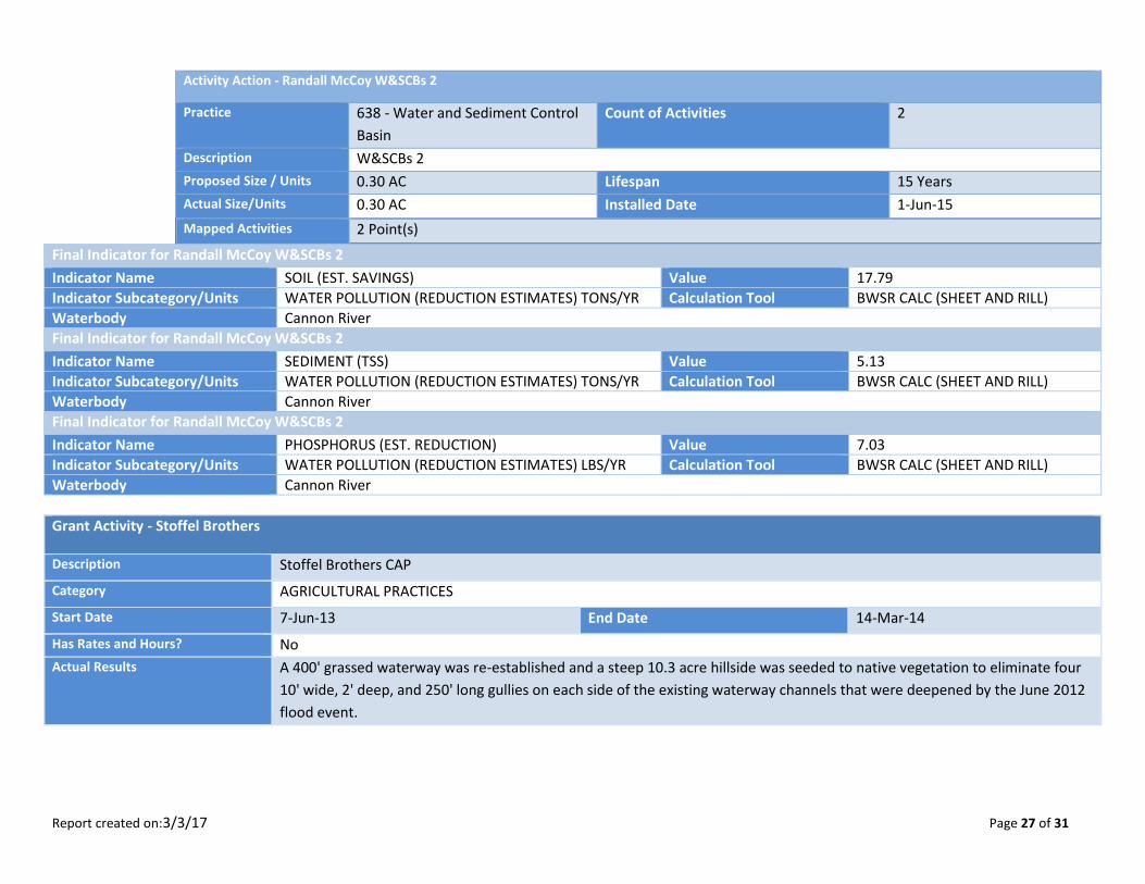
Report created on:3/3/17 Page 27 of 31
Activity Action - Randall McCoy W&SCBs 2
Practice 638 - Water and Sediment Control
Basin
Count of Activities 2
Description W&SCBs 2
Proposed Size / Units 0.30 AC Lifespan 15 Years
Actual Size/Units 0.30 AC Installed Date 1-Jun-15
Mapped Activities 2 Point(s)
Final Indicator for Randall McCoy W&SCBs 2
Indicator Name SOIL (EST. SAVINGS) Value 17.79
Indicator Subcategory/Units WATER POLLUTION (REDUCTION ESTIMATES) TONS/YR Calculation Tool BWSR CALC (SHEET AND RILL)
Waterbody Cannon River
Final Indicator for Randall McCoy W&SCBs 2
Indicator Name SEDIMENT (TSS) Value 5.13
Indicator Subcategory/Units WATER POLLUTION (REDUCTION ESTIMATES) TONS/YR Calculation Tool BWSR CALC (SHEET AND RILL)
Waterbody Cannon River
Final Indicator for Randall McCoy W&SCBs 2
Indicator Name PHOSPHORUS (EST. REDUCTION) Value 7.03
Indicator Subcategory/Units WATER POLLUTION (REDUCTION ESTIMATES) LBS/YR Calculation Tool BWSR CALC (SHEET AND RILL)
Waterbody Cannon River
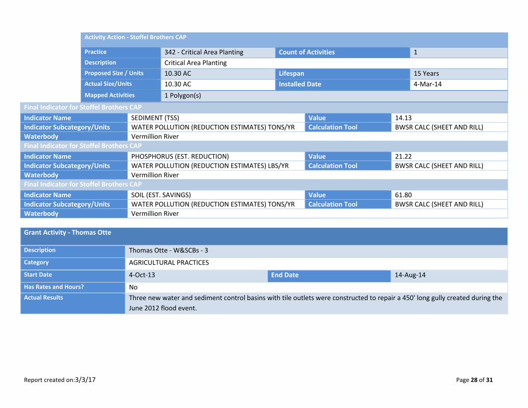
Grant Activity - Stoffel Brothers
Description Stoffel Brothers CAP
Category AGRICULTURAL PRACTICES
Start Date 7-Jun-13 End Date 14-Mar-14
Has Rates and Hours? No
Actual Results A 400' grassed waterway was re-established and a steep 10.3 acre hillside was seeded to native vegetation to eliminate four
10' wide, 2' deep, and 250' long gullies on each side of the existing waterway channels that were deepened by the June 2012
flood event.
Report created on:3/3/17 Page 28 of 31
Activity Action - Stoffel Brothers CAP
Practice 342 - Critical Area Planting Count of Activities 1
Description Critical Area Planting
Proposed Size / Units 10.30 AC Lifespan 15 Years
Actual Size/Units 10.30 AC Installed Date 4-Mar-14
Mapped Activities 1 Polygon(s)
Final Indicator for Stoffel Brothers CAP
Indicator Name SEDIMENT (TSS) Value 14.13
Indicator Subcategory/Units WATER POLLUTION (REDUCTION ESTIMATES) TONS/YR Calculation Tool BWSR CALC (SHEET AND RILL)
Waterbody Vermillion River
Final Indicator for Stoffel Brothers CAP
Indicator Name PHOSPHORUS (EST. REDUCTION) Value 21.22
Indicator Subcategory/Units WATER POLLUTION (REDUCTION ESTIMATES) LBS/YR Calculation Tool BWSR CALC (SHEET AND RILL)
Waterbody Vermillion River
Final Indicator for Stoffel Brothers CAP
Indicator Name SOIL (EST. SAVINGS) Value 61.80
Indicator Subcategory/Units WATER POLLUTION (REDUCTION ESTIMATES) TONS/YR Calculation Tool BWSR CALC (SHEET AND RILL)
Waterbody Vermillion River
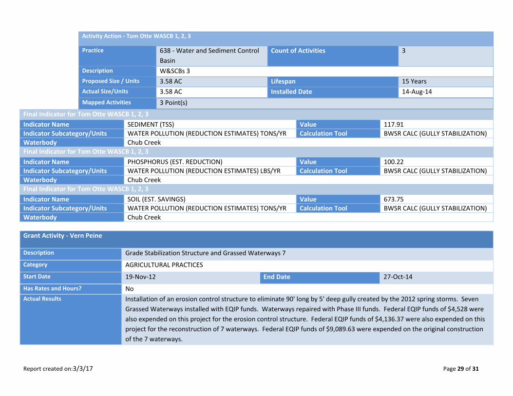
Grant Activity - Thomas Otte
Description Thomas Otte - W&SCBs - 3
Category AGRICULTURAL PRACTICES
Start Date 4-Oct-13 End Date 14-Aug-14
Has Rates and Hours? No
Actual Results Three new water and sediment control basins with tile outlets were constructed to repair a 450' long gully created during the
June 2012 flood event.
Report created on:3/3/17 Page 29 of 31
Activity Action - Tom Otte WASCB 1, 2, 3
Practice 638 - Water and Sediment Control
Basin
Count of Activities 3
Description W&SCBs 3
Proposed Size / Units 3.58 AC Lifespan 15 Years
Actual Size/Units 3.58 AC Installed Date 14-Aug-14
Mapped Activities 3 Point(s)
Final Indicator for Tom Otte WASCB 1, 2, 3
Indicator Name SEDIMENT (TSS) Value 117.91
Indicator Subcategory/Units WATER POLLUTION (REDUCTION ESTIMATES) TONS/YR Calculation Tool BWSR CALC (GULLY STABILIZATION)
Waterbody Chub Creek
Final Indicator for Tom Otte WASCB 1, 2, 3
Indicator Name PHOSPHORUS (EST. REDUCTION) Value 100.22
Indicator Subcategory/Units WATER POLLUTION (REDUCTION ESTIMATES) LBS/YR Calculation Tool BWSR CALC (GULLY STABILIZATION)
Waterbody Chub Creek
Final Indicator for Tom Otte WASCB 1, 2, 3
Indicator Name SOIL (EST. SAVINGS) Value 673.75
Indicator Subcategory/Units WATER POLLUTION (REDUCTION ESTIMATES) TONS/YR Calculation Tool BWSR CALC (GULLY STABILIZATION)
Waterbody Chub Creek
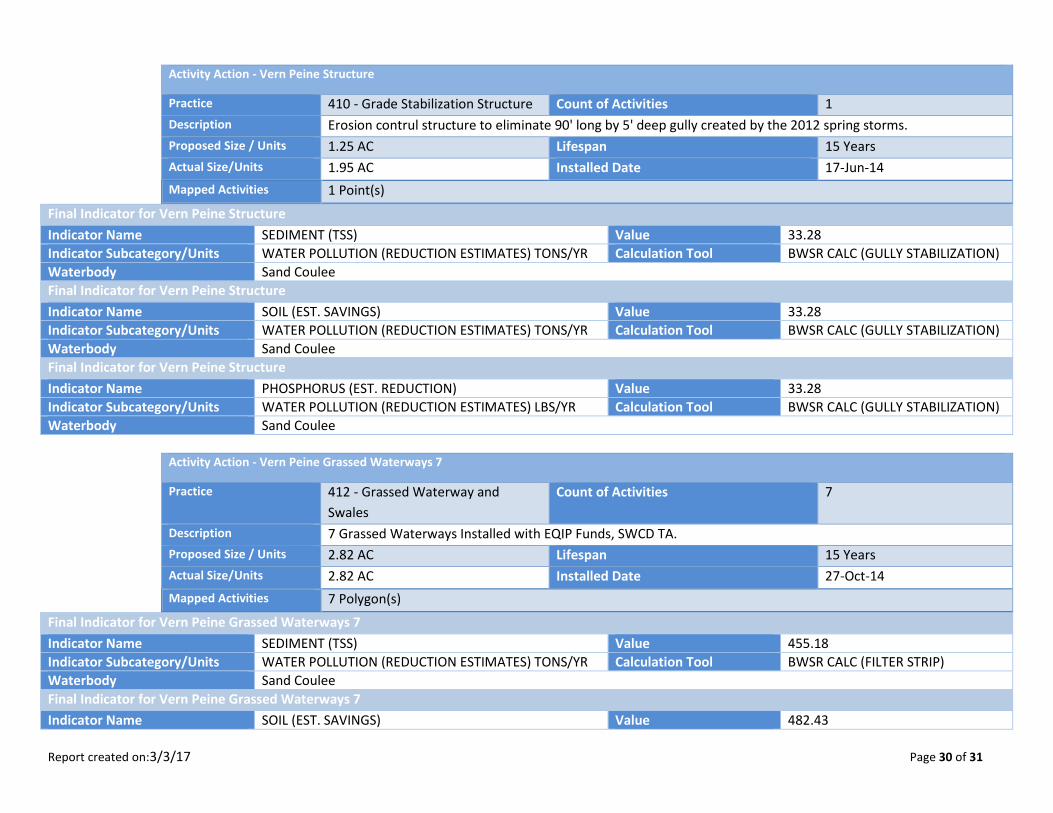
Grant Activity - Vern Peine
Description Grade Stabilization Structure and Grassed Waterways 7
Category AGRICULTURAL PRACTICES
Start Date 19-Nov-12 End Date 27-Oct-14
Has Rates and Hours? No
Actual Results Installation of an erosion control structure to eliminate 90' long by 5' deep gully created by the 2012 spring storms. Seven
Grassed Waterways installed with EQIP funds. Waterways repaired with Phase III funds. Federal EQIP funds of $4,528 were
also expended on this project for the erosion control structure. Federal EQIP funds of $4,136.37 were also expended on this
project for the reconstruction of 7 waterways. Federal EQIP funds of $9,089.63 were expended on the original construction
of the 7 waterways.
Report created on:3/3/17 Page 30 of 31
Activity Action - Vern Peine Structure
Practice 410 - Grade Stabilization Structure Count of Activities 1
Description Erosion contrul structure to eliminate 90' long by 5' deep gully created by the 2012 spring storms.
Proposed Size / Units 1.25 AC Lifespan 15 Years
Actual Size/Units 1.95 AC Installed Date 17-Jun-14
Mapped Activities 1 Point(s)
Final Indicator for Vern Peine Structure
Indicator Name SEDIMENT (TSS) Value 33.28
Indicator Subcategory/Units WATER POLLUTION (REDUCTION ESTIMATES) TONS/YR Calculation Tool BWSR CALC (GULLY STABILIZATION)
Waterbody Sand Coulee
Final Indicator for Vern Peine Structure
Indicator Name SOIL (EST. SAVINGS) Value 33.28
Indicator Subcategory/Units WATER POLLUTION (REDUCTION ESTIMATES) TONS/YR Calculation Tool BWSR CALC (GULLY STABILIZATION)
Waterbody Sand Coulee
Final Indicator for Vern Peine Structure
Indicator Name PHOSPHORUS (EST. REDUCTION) Value 33.28
Indicator Subcategory/Units WATER POLLUTION (REDUCTION ESTIMATES) LBS/YR Calculation Tool BWSR CALC (GULLY STABILIZATION)
Waterbody Sand Coulee
Activity Action - Vern Peine Grassed Waterways 7
Practice 412 - Grassed Waterway and
Swales
Count of Activities 7
Description 7 Grassed Waterways Installed with EQIP Funds, SWCD TA.
Proposed Size / Units 2.82 AC Lifespan 15 Years
Actual Size/Units 2.82 AC Installed Date 27-Oct-14
Mapped Activities 7 Polygon(s)
Final Indicator for Vern Peine Grassed Waterways 7
Indicator Name SEDIMENT (TSS) Value 455.18
Indicator Subcategory/Units WATER POLLUTION (REDUCTION ESTIMATES) TONS/YR Calculation Tool BWSR CALC (FILTER STRIP)
Waterbody Sand Coulee
Final Indicator for Vern Peine Grassed Waterways 7
Indicator Name SOIL (EST. SAVINGS) Value 482.43
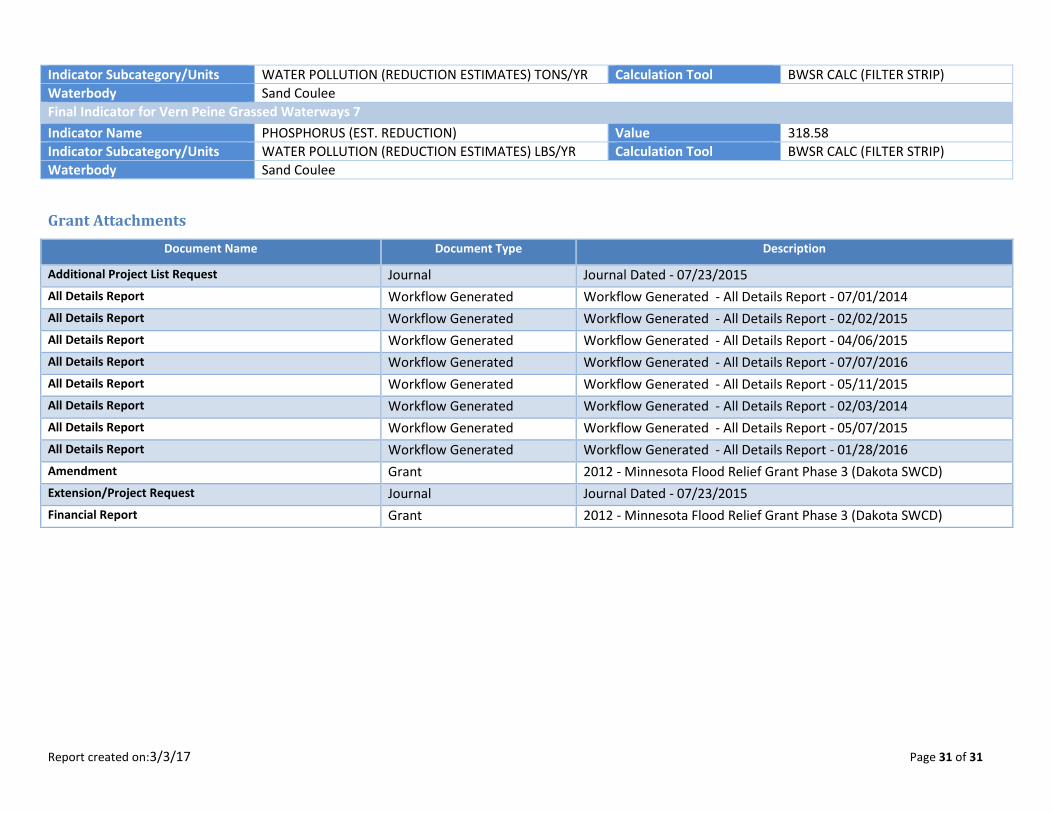
Report created on:3/3/17 Page 31 of 31
Indicator Subcategory/Units WATER POLLUTION (REDUCTION ESTIMATES) TONS/YR Calculation Tool BWSR CALC (FILTER STRIP)
Waterbody Sand Coulee
Final Indicator for Vern Peine Grassed Waterways 7
Indicator Name PHOSPHORUS (EST. REDUCTION) Value 318.58
Indicator Subcategory/Units WATER POLLUTION (REDUCTION ESTIMATES) LBS/YR Calculation Tool BWSR CALC (FILTER STRIP)
Waterbody Sand Coulee
Grant Attachments
Document Name Document Type Description
Additional Project List Request Journal Journal Dated - 07/23/2015
All Details Report Workflow Generated Workflow Generated - All Details Report - 07/01/2014
All Details Report Workflow Generated Workflow Generated - All Details Report - 02/02/2015
All Details Report Workflow Generated Workflow Generated - All Details Report - 04/06/2015
All Details Report Workflow Generated Workflow Generated - All Details Report - 07/07/2016
All Details Report Workflow Generated Workflow Generated - All Details Report - 05/11/2015
All Details Report Workflow Generated Workflow Generated - All Details Report - 02/03/2014
All Details Report Workflow Generated Workflow Generated - All Details Report - 05/07/2015
All Details Report Workflow Generated Workflow Generated - All Details Report - 01/28/2016
Amendment Grant 2012 - Minnesota Flood Relief Grant Phase 3 (Dakota SWCD)
Extension/Project Request Journal Journal Dated - 07/23/2015
Financial Report Grant 2012 - Minnesota Flood Relief Grant Phase 3 (Dakota SWCD)