Embed Size (px)
Citation preview
Preliminary Investigation Caltrans Division of Research and Innovation Produced by CTC & Associates LLC
Use of GPS for Equipment and Fleet Management by State DOTs
Requested by
Larry Orcutt, Division of Equipment
December 16, 2011 The Caltrans Division of Research and Innovation (DRI) receives and evaluates numerous research problem statements for funding every year. DRI conducts Preliminary Investigations on these problem statements to better scope and prioritize the proposed research in light of existing credible work on the topics nationally and internationally. Online and print sources for Preliminary Investigations include the National Cooperative Highway Research Program (NCHRP) and other Transportation Research Board (TRB) programs, the American Association of State Highway and Transportation Officials (AASHTO), the research and practices of other transportation agencies, and related academic and industry research. The views and conclusions in cited works, while generally peer reviewed or published by authoritative sources, may not be accepted without qualification by all experts in the field.
Executive Summary
Background Caltrans is currently in the process of deciding whether to add GPS systems to its equipment, including mobile rolling stock such as trucks, sedans, snowplows and attachments such as CMS signs. The goal of these installations would be to manage equipment more efficiently: getting the right equipment to the right place as quickly as possible, eliminating employee misuse of equipment (such as “illicit commuting”), improving diagnostic and repair capabilities, responding to emergencies, and saving on fuel, repairs and replacement costs due to mileage reductions. However, the cost of adding GPS is estimated to be from $10 to $20 million for Caltrans’ fleet of 6,000 vehicles. Caltrans is interested in learning from the experiences of other states about the costs and benefits of using GPS for fleet and equipment management. This preliminary investigation focused on surveying state DOTs, other agencies and companies to answer the following questions:
• Do state DOTs (and other organizations) use GPS on their equipment? • On what percentage of their fleet do they use GPS? Do they rotate the fleet that has GPS with
the fleet that doesn’t have GPS? • How do they use GPS? Do they use it for dispatch to help with emergencies? • What systems do they use? Are the systems add-on, as opposed to installed standard with the
vehicle? • What data are they collecting and for what purpose? • What are the costs and benefits of using GPS? • How do states pay for GPS systems – by the month or in a lump sum?
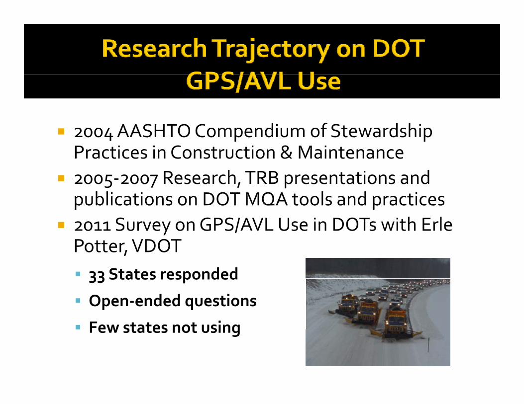
Summary of Findings We found a presentation to the AASHTO Maintenance Meeting summarizing the results of a survey of state DOTs on their use of GPS and automatic vehicle location technologies (AVL). This survey found that 27 of 33 respondents were using GPS, and details state use of systems (hardware and software), data collection and usage, problems and other issues. The survey found that the most common use for GPS is on snow plows and for general vehicle location (to improve route efficiencies). For more information, see GPS/AVL Technologies in Use at State DOTs in Related Research.
2
We successfully contacted eight states – five that are included in the AASHTO survey (IA, NM, NY, PA and WA) and three that are not (IN, OR and WI). States were selected based on AASHTO survey results indicating their use of the most common technologies, collection of a wide range of data, and use of data related to equipment management and incident response. They were also selected based on indications from online searching or other interviewees that states made significant use of GPS. The most prominent users of GPS we successfully contacted were Washington, Iowa and Pennsylvania. Other states that seem to be prominent users of GPS that we were unable to reach include Arizona, Virginia and Missouri. We were also unsuccessful in reaching non-DOT agencies and private companies. Below we detail key findings in four categories:
• Use • Systems • Cost • Benefits
Use States are primarily using GPS systems on snow plows, for AVL during storms and in order to track salt application and weather and road condition data. They generally use different systems to track fuel (with the exception of Indiana, and Washington has plans to transition its fuel-tracking to GPS). No states said that they rotated GPS with non-GPS vehicles. Indiana and Oregon also use GPS to monitor idling, and Iowa and Oregon use it to track engine diagnostics. Oregon and Washington both have plans to expand their use of GPS to track equipment diagnostics for maintenance purposes. New Mexico, which no longer uses GPS, experimented with using it to track vehicle maintenance but found it not to be cost-effective; however, NMDOT believes it can be cost-effective if there is enough staff to review and manage data. Pennsylvania, Washington and Wisconsin use GPS for emergency dispatch, and Oregon will use it for dispatch in the future. Systems Each state uses a different proprietary technology. Indiana’s systems include IWAPI Weather Management Data Collection, which according to the AASHTO survey is the most popular system used by states. Other systems reporting use by more than one state in the AASHTO survey and mentioned by respondents to our inquiries were Force/Precise, AmeriTrak, MDSS, Location Technologies and Network Fleet. Washington uses a combination of proprietary technologies and its own custom development of software allowing integration with GIS systems. Costs Hardware costs ranged from $2,500 to $8,000 for snow plow installations (with a median of $5,000) and $500 for light vehicles (which require less equipment). Cellular data fees were typically reported to be $30 per month. New York also reported a onetime setup fee of $10 and hosting fees for a Web site used to access data ($221 monthly). Benefits Three states we contacted – Iowa, Pennsylvania and Washington – spoke very highly of the benefits of using GPS for fleet management. Four states (Indiana, New York, Oregon, and Wisconsin) are still evaluating GPS benefits, although Oregon has high expectations. New Mexico ceased using GPS because of cost – and specifically evaluated the cost effectiveness of using it to track vehicle maintenance. However, they believe that with enough staff to manage data GPS can be used cost-effectively. Iowa conducted a cost-benefit analysis of its use of GPS and found $6.4 of benefit for every $1 of cost. Iowa, Oregon and Washington also noted that GPS is important to reducing tort liability.
3
Washington spoke extremely enthusiastically about the use of GPS, noting that if it is “done right” it will have a very high benefit to cost ratio. Of the states we contacted, Washington was both the most enthusiastic and experienced: it uses a variety of vendors and its own custom solutions to track a wide range of data (and is continually expanding its use of GPS). Washington expressed a willingness to offer assistance to less experienced states in setting up a system (it has substantial experience with vendors). See Winter Operations GPS Truck Tracking and Material Usage in Related Research for a presentation describing WSDOT’s system.
Contacts Departments of Transportation Indiana Joe Rudolph Director of Technical Services and District Support (317) 232-1495, [email protected] Iowa Annette M. Dunn Winter Operations Administrator Office of Maintenance (515) 239-1355, [email protected] New Mexico Tom Trujillo Highway Equipment Manager, Fleet Management Bureau (505) 827-5587, [email protected] New York Michael H. Lashmet Snow and Ice Program Engineer Office of Transportation Maintenance (518) 457-5796, [email protected] Oregon Bruce Erickson Fleet Services Manager Office of Maintenance & Operations (503) 986-2734, [email protected] Pennsylvania W. James Smith Chief, Bureau of Maintenance and Operations Fleet Management Division (717) 787-4299, [email protected] Washington Tom Clay Maintenance and Operations (360) 705-7847, [email protected]
4
Wisconsin Todd Matheson Bureau of Highway Maintenance (608) 266-1202, [email protected] Other Organizations TRB Maintenance Equipment Committee Joseph L. Darling, Chair [email protected] National Conference of State Fleet Administrators Cindy Dixon, (573) 751-4534, [email protected]
5
Consultation with GPS Users State Departments of Transportation that Use or Have Used GPS for Fleet Management Indiana Use: Indiana has been using GPS on 140 of 1,200 snow plows for several years. As part of a more recent research pilot project, it uses GPS on about 12 paint striping vehicles. IDOT is evaluating whether they can improve their efficiency and reduce their number of paint trucks. GPS is used for AVL, to track salt application, and to monitor idling, fuel usage and other operational data. On paint trucks systems monitor when compressors fire, when emergency lights are on, when edgeline guns spray, vehicle speed, engine hours, flow rates, and other data. On snow plows, they monitor when the plow is up or down, when hydraulics are activated, spinner rate, ambient road temperature, etc. Systems: Skyview, IWAPI, and Gauge Telematics Earthways. Costs and Benefits: Initial pilot tests on snow plows were conducted at no cost – vendors supplied equipment without charge. Currently the cost is $5,000 per truck for hardware, and $30 to $40 a month per truck for data airtime fees. For the current pilot tests on paint trucks, hardware is $500 per vehicle, with $30 to $40 a month per vehicle for data airtime fees. Indiana is still evaluating the benefits of using GPS. Iowa Use: The Iowa DOT uses GPS on all of its safety vehicles (for helping stranded motorists) and on 40 percent of its snow plows (and does not rotate). They use GPS on plows for AVL during storms, and track the type and amount of salt and other materials that have been placed on roadways. In order to make better business decisions about winter operations, Iowa DOT collects data on: engine diagnostics, spreader control information, position locator, time locator, road and air temperatures, and plow position. Systems: Location Technology, Inc. LT6 GPS system. Costs and Benefits: The cost is $2,500 to $4,200 per truck for the equipment and $11 per month per truck for air cards to send data. Iowa DOT ran a cost-benefit analysis on outfitting its snowplows with GPS and data tracking systems. Iowa found its benefit-to-cost ratio to be 6.4 (or $6.4 of benefit for every $1 of cost). Benefits include:
• For The Agency: o Reduced material costs o Reduced labor costs o Reduced equipment costs o Reduced paperwork o More efficient fleet management o More comprehensive information on vehicle operations, road conditions, and
materials usage o Provides better information for decision making o Increased security for drivers o Reduced legal costs from tort claims allegedly involving maintenance vehicles o Streamlined report generation o Reduced reliance on radio communications - less driver distraction o Better management of maintenance functions on a year-round basis o Improved tracking for emergency response
6
• For Motorists: o Improved safety o Reduced traffic delay o Better road customer satisfaction
• For Society: o Reduced impact on the environment (e.g., water, vegetation, and wildlife)
New Mexico Use: NMDOT used GPS for 25 Dump Trucks, used for salting during storms and to help stranded drivers. This program was terminated and NMDOT then used five GPS units for a year on motorpool sedans and SUVs to see if there would be a maintenance notification benefit. Because they do frequent preventative maintenance on motorpool units, there was no benefit and they ceased using GPS altogether in November, 2011. Systems: NMDOT used Network Fleet. Costs and Benefits: Costs were about $500 for each unit, activation fees of $125 per unit, and a service fee of $30 per month per unit. NMDOT found that in order to achieve cost savings, the use of GPS requires enough staff to review and manage data on a regular basis. NMDOT did not have the appropriate staff and did not see cost savings. New York Use: NYSDOT uses GPS on 30 of 1,400 trucks, as part of a maintenance decision support (MDSS) pilot. They monitor speed, location and material applications. They do not track fuel usage, engine temperature, or similar data. The system makes recommendations on when to deploy trucks and how much salt to apply based on weather and road conditions. Systems: Ameritrak. Costs and Benefits: About $500 per truck for hardware; $962 per month total for cellular data transfer; and $221 per month for Web hosting (data is accessed through a Web interface). There is a onetime connection fee of $10 per truck. The systems are working well – NYSDOT is still evaluating benefits, for example whether they can save money on salt. Oregon Use: Oregon currently makes limited use of GPS but plans to expand its use. One percent of its fleet is equipped with GPS and these are not rotated with non-GPS fleet. GPS is currently used to support idle reduction and engine diagnostics, and ODOT will expand to use for AVL and winter maintenance activities. With this expansion, data will be collected for AVL and dispatch purposes, equipment diagnostics for fleet management and automating winter maintenance activities. Systems: ODOT uses Volvo Link and a service provider that communicates with existing devices. Costs and benefits: $6,000 per Class 8 truck. ODOT expects fully automated sanding logs to save staff time. It will also be much easier to defend a tort claim with the exact dates, times and quantities of plowing, sanding and deicing. Winning one lawsuit will pay for outfitting the entire fleet. Truck diagnostics are expected to reduce fuel usage from idling (GPS will allow monitoring who, when and how long a piece of equipment idles). And productivity should go up when a vehicle can be tracked when it leaves the highway – geofencing will allow alerts when it leaves its assigned area. Dispatch will be able to see and track units on the AVL system for more efficient dispatch to trouble spots, and winter maintenance materials costs will be reduced by improving monitoring of application rates.
7
Pennsylvania Use: PDOT uses GPS on 100 percent of its fleet to monitor and manage its workforce and for emergency dispatch. They track fuel using a different system. Systems: PDOT uses an 800 MHz radio system and a GPS responder to track units. The responder sends the signal to the satellite and then the radio sends the data back to the server. They use GATIR (Geospatial Analysis of Threats and Incident Reports) as the platform to disseminate and display the information graphically on its maps. GATIR is a system that was developed by a local engineering firm (Gannett Fleming). Costs and Benefits: Information on cost was not available. PDOT considers the system to be very beneficial, and will be adding numerous enhancements to collect vehicle data and information on operational configurations such as (for snow plows) plow up/down, spreader on/off, and the rate of applications and materials being dispensed. Washington Use: WSDOT uses GPS on 280 of its 420 snow plows and nine incident response vehicles. They have been using GPS for five years, and in the next two to three years plan to expand it to a total of 600 vehicles. Initial pilot tests in 2004 were not successful (data loss and cost were unacceptable), but by 2007 the technology had advanced enough to make good use of it. On incident response vehicles GPS is used for dispatch, and on snow plows it is used to track: location, speed, travel direction, materials placement (sand or salt), road and air temperatures, road conditions and weather. It also determines the cost of storm events by tracking labor, equipment and materials. A different system is used for fuel tracking, but WSDOT will eventually transition this to GPS. They may also begin tracking data that will allow equipment personnel to manage maintenance timelines. Systems: Force for controllers and Precise to capture data (Precise is now a subsidiary of Force). WSDOT calls this a “great package deal” with excellent support. But they have also highly customized this system by integrating it with other proprietary systems (including Location Technologies) and their own custom software, developed in-house. WSDOT’s custom system is extremely innovative, integrates with GIS mapping technologies, and can display, for example, how much salt has been placed between two mileposts on a given route, something that no vendor-supplied solution can do out of the box. See Winter Operations GPS Truck Tracking and Material Usage in Related Research for a presentation describing WSDOT’s system. WSDOT recommends beginning with a vendor solution and then customizing depending on data needs. (Again, because of customizations, WSDOT’s system is much more robust than can be provided by any vendor). Costs and Benefits: WSDOT has spent a total of $350,000, $8,000 per truck ($5,000 for a controller, $1,500 for a manual data entry box for road conditions and other data, and $1,500 for other equipment). Data streaming costs $29.95 (for an unlimited plan) per vehicle per month. WSDOT finds this highly cost effective, and use of the GPS system is much less labor intensive than the manual processes it replaced. It is also extremely important for tort liability – WSDOT knows precisely where it has placed salt. It considers the system a “phenomenal” benefit, one that does not have to be prohibitively expensive if done right. Wisconsin Use: 44 of the 72 counties in Wisconsin have GPS installed on plow trucks which plow and maintain the state highway system. All of the portable changeable message boards in the state have GPS. This constitutes 65 percent of plow trucks statewide (there is no rotation), with some counties having 100 percent of their fleet equipped. Sensors determine plow-up/plow down and salt application rates. Information is also made available to emergency operations for dispatch purposes.
8
Systems: MDSS (Maintenance Decision Support System – add on). Costs and Benefits: Costs range significantly depending on the type of information and the complexity of the system. Equipment costs are approximately $3,000 to $5,000 per vehicle. Plow trucks have many sensors installed in addition to just positioning information, which increases costs. There is also a yearly fee of $150 per truck and monthly communication fees which range from $40 to $80 per month. WisDOT is still evaluating benefits. Other States We attempted to contact but did not get a response from the following states, because they were reported by other respondents to be prominent users of GPS:
• Arizona • Virginia • Missouri
State Departments of Transportation Not Using GPS for Fleet Management In the course of enquiries we learned that the following states do not use GPS on vehicles:
• Alaska – although they are currently examining the possibility. • Arkansas – although they are currently examining the possibility. • Hawaii – because of problems with labor unions. • Illinois – although they are currently examining the possibility. • Mississippi – because of cost. • Montana. • South Carolina – because of cost and concerns about data security. • Texas – because of cost.
Other Agencies, Committees and Companies We contacted Joseph Darling of the TRB Maintenance Equipment Committee and Cindy Dixon of the National Conference of State Fleet Administrators, who were unable to provide information on or contact leads for this topic. We attempted unsuccessfully to reach the following agencies and companies:
• The City of Los Angeles • Pacific Gas and Electric • Los Angeles Department of Water and Power • Southern California Edison • Fedex • UPS
Calls and emails to the City of Los Angeles and Pacific Gas and Electric went unreturned. Fedex and UPS have a policy of not responding to inquiries by researchers and academics. And we were unable to locate appropriate contacts for the Los Angeles Department of Water and Power and Southern California Edison.
9
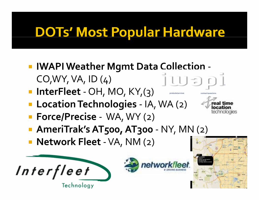
Related Research GPS/AVL Technologies in Use at State DOTs, Marie Venner, AASHTO Maintenance Meeting, July 19, 2011. http://transportation.ky.gov/Maintenance/Documents/AASHTO%20Presentations/General/AVL%20GPS/GPS%20AVL%20Technologies%20in%20Use%20at%20State%20DOTs.pptx (and Appendix A) This presentation details the results of a survey of state departments of transportation on their use of GPS. We were unsuccessful in our attempts to reach Ms. Venner for a full report and survey results, and a Web search similarly did not reveal a report available online. However, the presentation itself has a wealth of data on this topic. Of 33 states responding to the survey, 27 are listed as using GPS for fleet management: AK, DE, CO, CT, DE, IA, ID, IL, KS, KY, LA, MD, MN, MO, MT, NC, ND, NE, NM, NY, OH, PA, SC, TN, VA, WA, WY. (Note that we were able to make follow up contact with five of these states, as well as a number of states that use GPS that seem not to have responded to this survey, including: IN, OR, and WI. Follow up contacts also showed that AK, AR, HI, IL, MS, MT SC and TX do not use GPS for fleet management (inconsistent with this presentation in the cases of IL, MT and SC); and NM no longer use GPS. Because of its relevance, we include much of the content from this presentation below. Hardware The most popular hardware used by states includes:
• IWAPI Weather Mgmt Data Collection - CO,WY, VA, ID (4) • InterFleet - OH, MO, KY,(3) • Location Technologies - IA, WA (2) • Force/Precise - WA, WY (2) • AmeriTrak’s AT500, AT300 - NY, MN (2) • Network Fleet - VA, NM (2)
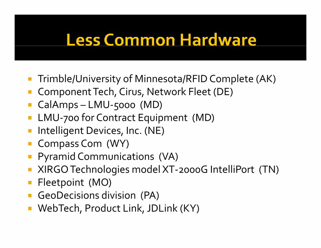
Less common hardware includes:
• Trimble/University of Minnesota/RFID Complete (AK) • Component Tech, Cirus, Network Fleet (DE) • CalAmps – LMU-5000 (MD) • LMU-700 for Contract Equipment (MD) • Intelligent Devices, Inc. (NE) • Compass Com (WY) • Pyramid Communications (VA) • XIRGO Technologies model XT-2000G IntelliPort (TN) • Fleetpoint (MO) • GeoDecisions division (PA) • WebTech, Product Link, JDLink (KY)
Software Applications in use include:
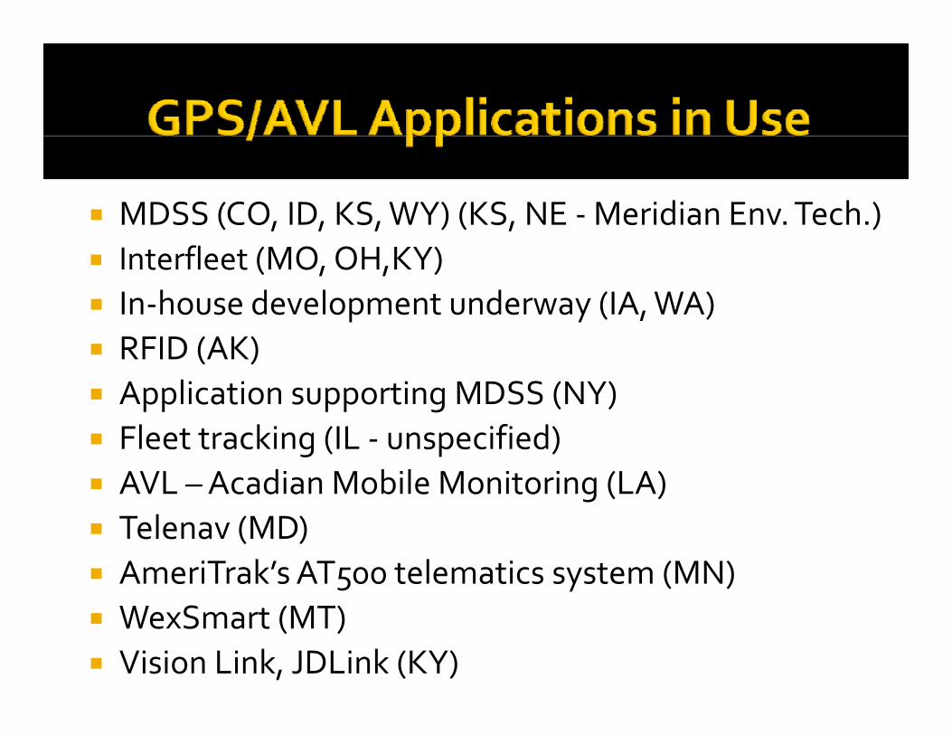
• MDSS (CO, ID, KS, WY) (KS, NE - Meridian Env. Tech.) • Interfleet (MO, OH,KY) • In-house development underway (IA, WA) • RFID (AK) • Application supporting MDSS (NY) • Fleet tracking (IL - unspecified) • AVL – Acadian Mobile Monitoring (LA) • Telenav (MD) • AmeriTrak’s AT500 telematics system (MN)
10
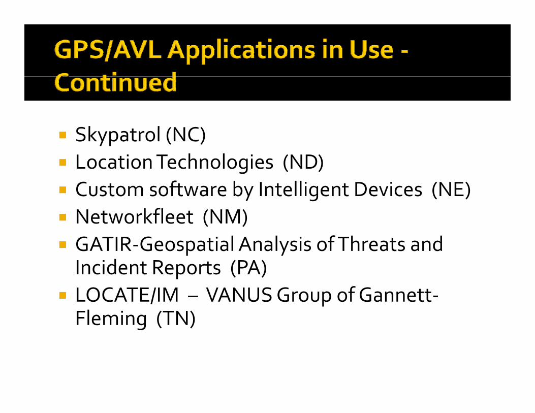
• WexSmart (MT) • Vision Link, JDLink (KY) • Skypatrol (NC) • Location Technologies (ND) • Custom software by Intelligent Devices (NE) • Networkfleet (NM) • GATIR-Geospatial Analysis of Threats and Incident Reports (PA) • LOCATE/IM – VANUS Group of Gannett-Fleming (TN)
Data Collection DOTs are collecting the following data with these systems:
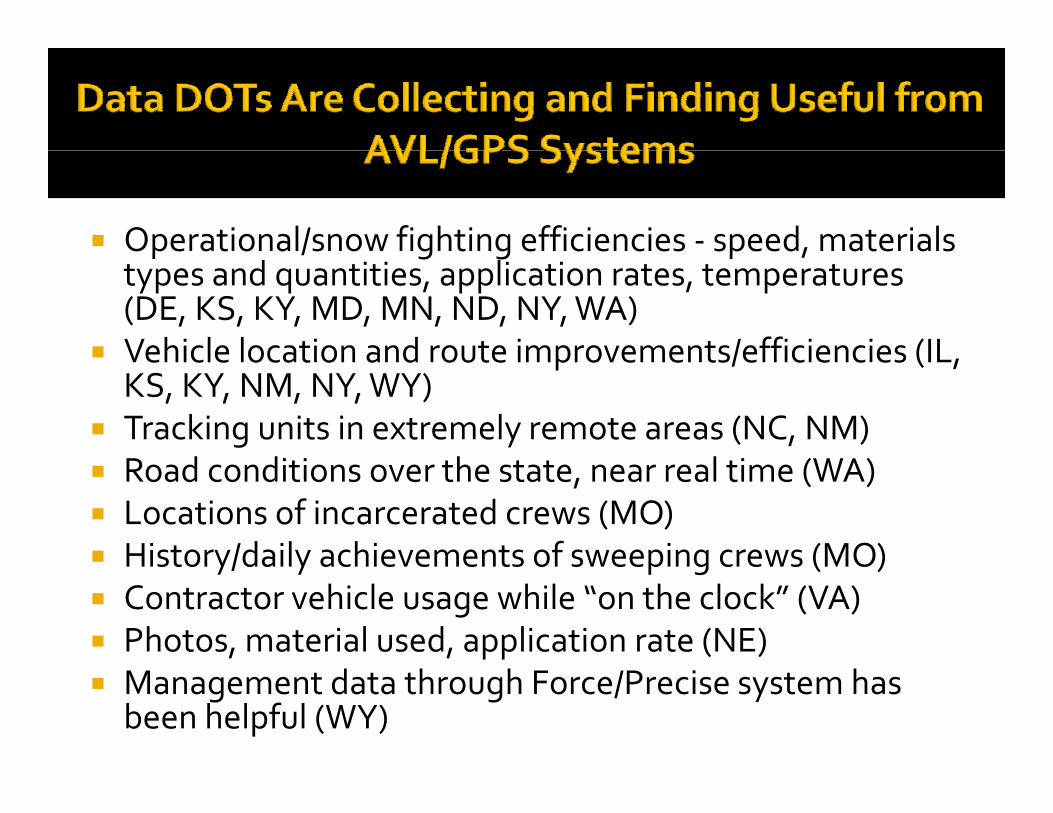
• Operational/snow fighting efficiencies - speed, materials types and quantities, application rates, temperatures (DE, KS, KY, MD, MN, ND, NY, WA)
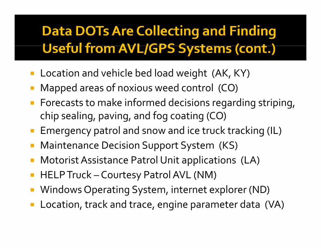
• Vehicle location and route improvements/efficiencies (IL, KS, KY, NM, NY, WY) • Tracking units in extremely remote areas (NC, NM) • Road conditions over the state, near real time (WA) • Locations of incarcerated crews (MO) • History/daily achievements of sweeping crews (MO) • Contractor vehicle usage while “on the clock” (VA) • Photos, material used, application rate (NE) • Management data through Force/Precise system has been helpful (WY) • Location and vehicle bed load weight (AK, KY) • Mapped areas of noxious weed control (CO) • Forecasts to make informed decisions regarding striping, chip sealing, paving, and fog coating
(CO) • Emergency patrol and snow and ice truck tracking (IL) • Maintenance Decision Support System (KS) • Motorist Assistance Patrol Unit applications (LA) • HELP Truck – Courtesy Patrol AVL (NM) • Windows Operating System, internet explorer (ND) • Location, track and trace, engine parameter data (VA)
Data Usage DOTs are using the data for the following purposes:
• Incident Command/Transportation Management Center Operations (LA, PA, TN, VA, WY) • DOT as a whole (MD, ND, NE, KY), management & supervisors (IL, NY), three highway
divisions (NC) • Fleet Equipment Bureau staff (MT, NC, PA) • Maintenance Managers, Engineers, Crew Supervisors, Sweeping Crew Managers (MO, VA) • Snow & Ice Operations Managers (OH) • Dispatch (IL, NM) • Meridian Environmental Technology, MDSS vendor (KS) • Director of Asset Management (NC) • Maintenance crews using MDSS and the maintenance crew using the Force/Precise system. (WY) • One District viewing data for material usage on a pilot and our MDSS Pilot Program (ID)
Problems Common problems include:
• Lack of adequate cell/data coverage, dead spots (IA,KS,MN,NC,NM,NY,WY) • Software malfunctions (operator, power supply, accuracy readings, device durability)
(AK,IA,IL,MN,NE, OH,LA) • Software compatibility issues (ID,NY, KY) or other installation problems (CT,ND)
11
• User interface-software (learning) (DE,KS,VA) • Hardware problems (ND, WA) e.g., mobile data computer hard drives corrupt (ND) or GPS
antenna failures (WA) • Perception (SC) • Cost (CO)
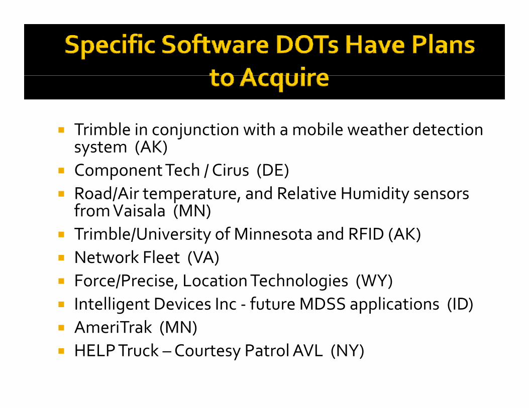
Other The presentation also includes further information on data DOTs would like to acquire, hardware installation issues, compatibility and data standards issues, data retrieval, hardware and software solutions under consideration by state DOTs, needs identified by DOTs, and DOTs’ further plans for implementation. CT, ND, NY, PA, WY and ND are still evaluating costs and benefits of GPS, IA and WA are building in-house applications, and LA plans to purchase Locate IM – VANUS by Gannett Fleming. States are looking at acquiring the following software:
• Trimble in conjunction with a mobile weather detection system (AK) • Component Tech / Cirus (DE) • Road/Air temperature, and Relative Humidity sensors from Vaisala (MN) • Trimble/University of Minnesota and RFID (AK) • Network Fleet (VA) • Force/Precise, Location Technologies (WY) • Intelligent Devices Inc - future MDSS applications (ID) • AmeriTrak (MN) • HELP Truck – Courtesy Patrol AVL (NY)
Winter Operations GPS Truck Tracking and Material Usage, Chris Christopher, Washington State Department of Transportation. See Appendix B. This document details WSDOT’s use of GPS for truck tracking (see also the results of our interview with WSDOT under Consultation with GPS Users). WSDOT uses a combination of proprietary and custom-built systems to track truck location, road condition information, and equipment and materials usage. 245 of 480 trucks are outfitted with systems; total costs are $1,960,000 for truck hardware ($8,000 per truck), $200,000 for a database and Web GIS system, and annual data charges of $90,000 ($7,300 per month). WSDOT is planning to implement these systems for the rest of its winter fleet and enhance them to include maintenance management information (labor hours and costs, equipment and materials). An Investigation of the Use of Differential Global Positioning System Technology within State and Local Transportation Departments, FHWA, July 2000. http://www.fhwa.dot.gov/publications/research/operations/its/00093.pdf This report summarizes the results of a 2000 FWHA survey on the use of GPS by state and local transportation agencies. Uses include emergency systems, highway inventory, and fleet management and automatic vehicle location. The report describes GPS usage for 21 states: Arizona, Colorado, Florida, Indiana, Iowa, Kansas, Louisiana, Michigan, Minnesota, Montana, Nevada, New Hampshire, New York, North Dakota, Oregon, South Dakota, Tennessee, Texas, Utah, Virginia, and Wisconsin. A GIS Framework for Construction Equipment Request and Deployment during Emergency Response, Construction Research Congress 2010 - Innovation for Reshaping Construction Practice, 2010: 480-489. Abstract at: http://trid.trb.org/view/2010/C/923889 Abstract: Efficient request and deployment of resources such as construction equipment is vital to urban search and rescue operations during emergency response. Based on the lessons learned in recent disasters, collecting, prioritizing and distributing of resources are urgent to life-saving operations. Construction equipment is required for shoring of structures, selective debris removal, and lifting of heavy building components. Infrastructure restoration, such as the transportation network, also needs construction

12
equipment to support its operations to bring back services to facilitate disaster response efforts. A Geographic Information System (GIS) framework is presented to expedite equipment management. Within the framework, automation of data collection, transfer and processing for fast decision-making via computer networks, geospatial services and mobile devices is proposed. With the framework deployed, lifesaving operations are expected to have better performance provided with the appropriate equipment.
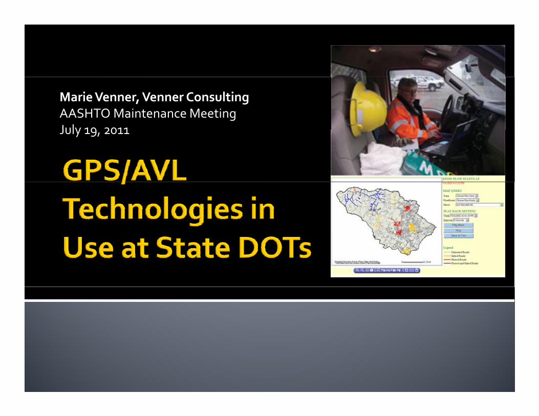
Marie Venner, Venner ConsultingAASHTO Maintenance Meeting July 19 2011July 19, 2011
AASHTO C di f St d hi 2004 AASHTO Compendium of Stewardship Practices in Construction & Maintenance
2005 2007 Research TRB presentations and 2005‐2007 Research, TRB presentations and publications on DOT MQA tools and practices
2011 Survey on GPS/AVL Use in DOTs with Erle 2011 Survey on GPS/AVL Use in DOTs with Erle Potter, VDOT 33 States responded33 States responded
Open‐ended questions
Few states not usingFew states not using
IWAPI Weather Mgmt Data Collection ‐CO,WY, VA, ID (4)
l InterFleet ‐OH, MO, KY,(3) Location Technologies ‐ IA, WA (2)
i Force/Precise ‐ WA, WY (2) AmeriTrak’s AT500, AT300 ‐NY, MN (2)
k l Network Fleet ‐VA, NM (2)
Trimble/University of Minnesota/RFID Complete (AK) Trimble/University of Minnesota/RFID Complete (AK) Component Tech, Cirus, Network Fleet (DE) CalAmps – LMU‐5000 (MD) p 5 ( ) LMU‐700 for Contract Equipment (MD) Intelligent Devices, Inc. (NE)
C C ( ) Compass Com (WY) Pyramid Communications (VA) XIRGO Technologies model XT‐2000G IntelliPort (TN) XIRGO Technologies model XT 2000G IntelliPort (TN) Fleetpoint (MO) GeoDecisions division (PA) WebTech, Product Link, JDLink (KY)
MDSS (CO, ID, KS, WY) (KS, NE ‐Meridian Env. Tech.)( , , , ) ( , ) Interfleet (MO, OH,KY) In‐house development underway (IA, WA) p y RFID (AK) Application supporting MDSS (NY) Fleet tracking (IL ‐ unspecified) AVL –Acadian Mobile Monitoring (LA) Telenav (MD) AmeriTrak’s AT500 telematics system (MN) WexSmart (MT) Vision Link, JDLink (KY)
Sk l (NC) Skypatrol (NC) Location Technologies (ND)
f Custom software by Intelligent Devices (NE) Networkfleet (NM) GATIR‐Geospatial Analysis of Threats and Incident Reports (PA)
LOCATE/IM – VANUS Group of Gannett‐Fleming (TN)
Operational/snow fighting efficiencies ‐ speed, materials p / g g p ,types and quantities, application rates, temperatures(DE, KS, KY, MD, MN, ND, NY, WA)
Vehicle location and route improvements/efficiencies (IL Vehicle location and route improvements/efficiencies (IL, KS, KY, NM, NY, WY)
Tracking units in extremely remote areas (NC, NM)d d h l ( ) Road conditions over the state, near real time (WA)
Locations of incarcerated crews (MO) History/daily achievements of sweeping crews (MO) History/daily achievements of sweeping crews (MO) Contractor vehicle usage while “on the clock” (VA) Photos, material used, application rate (NE) Management data through Force/Precise system has
been helpful (WY)
Location and vehicle bed load weight (AK, KY)g ( , ) Mapped areas of noxious weed control (CO) Forecasts to make informed decisions regarding striping, g g p g
chip sealing, paving, and fog coating (CO) Emergency patrol and snow and ice truck tracking (IL) Maintenance Decision Support System (KS) Motorist Assistance Patrol Unit applications (LA)
k C l ( ) HELP Truck –Courtesy Patrol AVL (NM) Windows Operating System, internet explorer (ND)
L ti t k d t i t d t (VA) Location, track and trace, engine parameter data (VA)
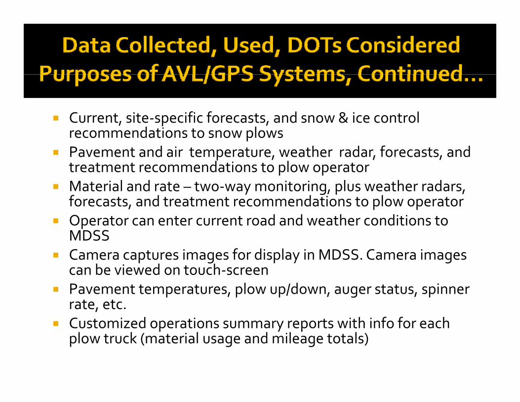
Current, site‐specific forecasts, and snow & ice control , p ,recommendations to snow plows
Pavement and air temperature, weather radar, forecasts, and treatment recommendations to plow operator
Material and rate – two‐way monitoring, plus weather radars, forecasts, and treatment recommendations to plow operator
Operator can enter current road and weather conditions to pMDSS
Camera captures images for display in MDSS. Camera images can be viewed on touch‐screen
Pavement temperatures, plow up/down, auger status, spinner rate, etc.
Customized operations summary reports with info for each Customized operations summary reports with info for each plow truck (material usage and mileage totals)
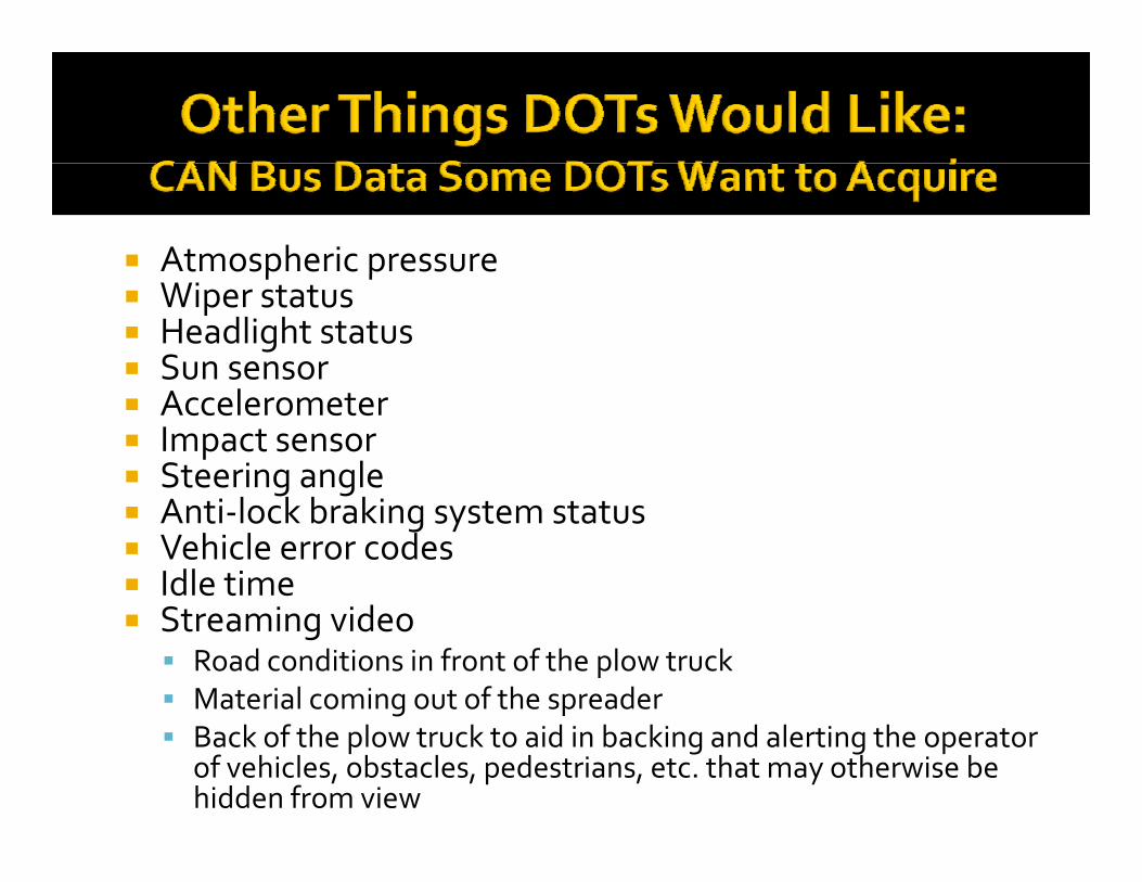
Atmospheric pressurep p Wiper status Headlight status Sun sensor Accelerometer Impact sensor Steering angle
l k b k Anti‐lock braking system status Vehicle error codes Idle time
S i id Streaming video Road conditions in front of the plow truck Material coming out of the spreader Back of the plow truck to aid in backing and alerting the operator
of vehicles, obstacles, pedestrians, etc. that may otherwise be hidden from view
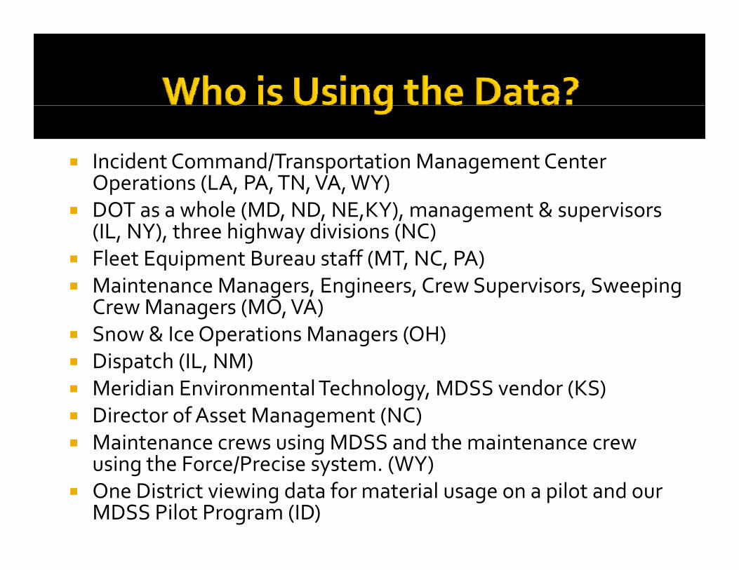
Incident Command/Transportation Management Center O ti (LA PA TN VA WY)Operations (LA, PA, TN, VA, WY)
DOT as a whole (MD, ND, NE,KY), management & supervisors (IL, NY), three highway divisions (NC)
Fleet Equipment Bureau staff (MT, NC, PA) Maintenance Managers, Engineers, Crew Supervisors, Sweeping
Crew Managers (MO, VA) Snow & Ice Operations Managers (OH) Dispatch (IL, NM) Meridian Environmental Technology, MDSS vendor (KS)Meridian Environmental Technology, MDSS vendor (KS) Director of Asset Management (NC) Maintenance crews using MDSS and the maintenance crew
using the Force/Precise system (WY)using the Force/Precise system. (WY) One District viewing data for material usage on a pilot and our
MDSS Pilot Program (ID)
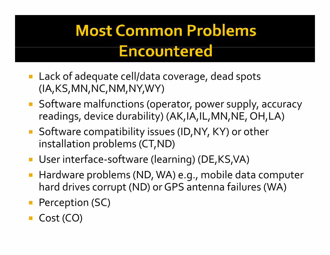
Lack of adequate cell/data coverage, dead spots Lack of adequate cell/data coverage, dead spots (IA,KS,MN,NC,NM,NY,WY)
Software malfunctions (operator, power supply, accuracy readings, device durability) (AK,IA,IL,MN,NE, OH,LA)
Software compatibility issues (ID,NY, KY) or other installation problems (CT ND) installation problems (CT,ND)
User interface‐software (learning) (DE,KS,VA) Hardware problems (ND WA) e g mobile data computer Hardware problems (ND, WA) e.g., mobile data computer
hard drives corrupt (ND) or GPS antenna failures (WA) Perception (SC) p Cost (CO)
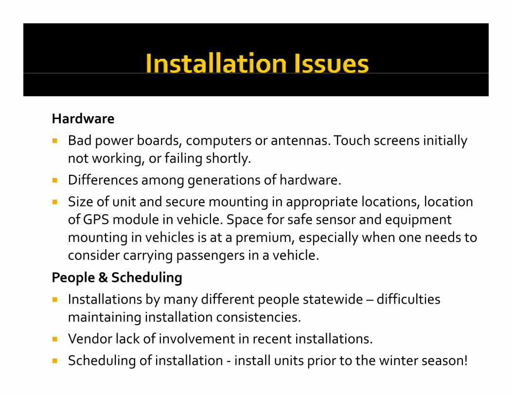
HardwareHardware Bad power boards, computers or antennas. Touch screens initially
not working, or failing shortly. Differences among generations of hardware. Size of unit and secure mounting in appropriate locations, location
of GPS module in vehicle Space for safe sensor and equipment of GPS module in vehicle. Space for safe sensor and equipment mounting in vehicles is at a premium, especially when one needs to consider carrying passengers in a vehicle.
l & S h d liPeople & Scheduling Installations by many different people statewide – difficulties
maintaining installation consistencies. g Vendor lack of involvement in recent installations. Scheduling of installation ‐ install units prior to the winter season!
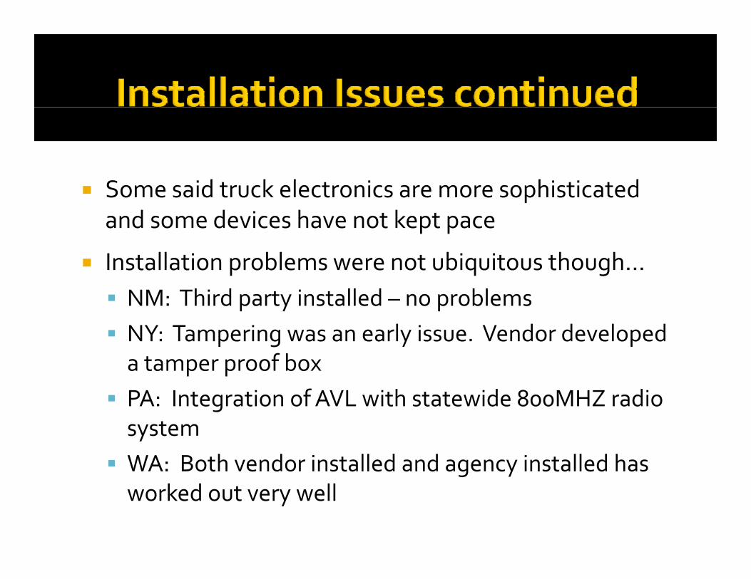
d k l h d Some said truck electronics are more sophisticated and some devices have not kept pace
ll bl b h h Installation problems were not ubiquitous though… NM: Third party installed – no problemsNY T i l i V d d l d NY: Tampering was an early issue. Vendor developed a tamper proof box
PA: Integration of AVL with statewide 800MHZ radio PA: Integration of AVL with statewide 800MHZ radio system
WA: Both vendor installed and agency installed has g yworked out very well
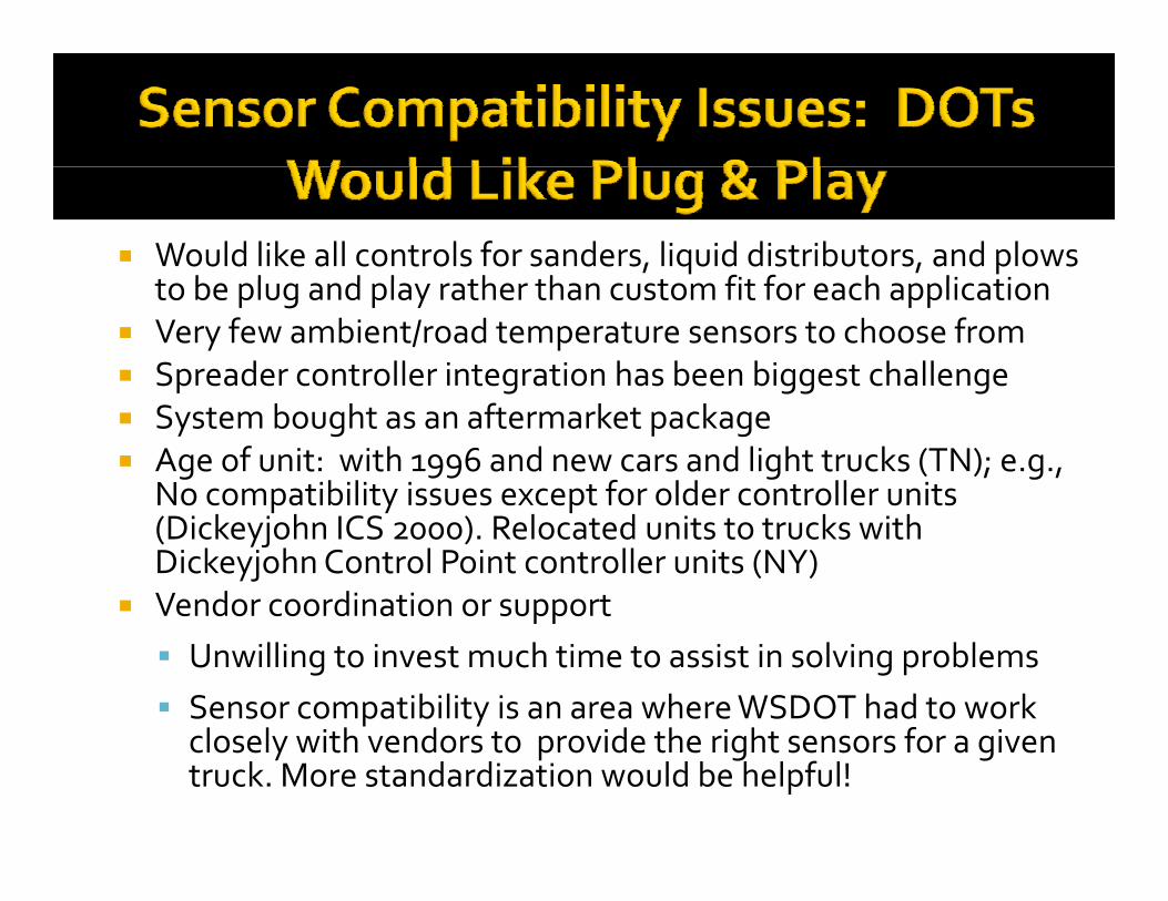
Would like all controls for sanders, liquid distributors, and plows t b l d l th th t fit f h li ti to be plug and play rather than custom fit for each application
Very few ambient/road temperature sensors to choose from Spreader controller integration has been biggest challenge g gg g System bought as an aftermarket package Age of unit: with 1996 and new cars and light trucks (TN); e.g.,
No compatibility issues except for older controller units p y p(Dickeyjohn ICS 2000). Relocated units to trucks with DickeyjohnControl Point controller units (NY)
Vendor coordination or supportpp Unwilling to invest much time to assist in solving problems Sensor compatibility is an area where WSDOT had to work
l l ith d t id th i ht f i closely with vendors to provide the right sensors for a given truck. More standardization would be helpful!
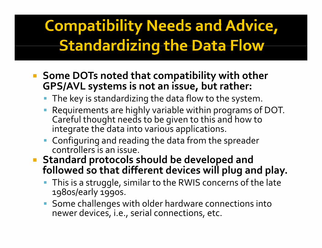
Some DOTs noted that compatibility with other Some DOTs noted that compatibility with other GPS/AVL systems is not an issue, but rather: The key is standardizing the data flow to the system.R i t hi hl i bl ithi f DOT Requirements are highly variable within programs of DOT. Careful thought needs to be given to this and how to integrate the data into various applications.
Configuring and reading the data from the spreader Configuring and reading the data from the spreader controllers is an issue.
Standard protocols should be developed and followed so that different devices will plug and playfollowed so that different devices will plug and play. This is a struggle, similar to the RWIS concerns of the late 1980s/early 1990s.
Some challenges with older hardware connections into Some challenges with older hardware connections into newer devices, i.e., serial connections, etc.
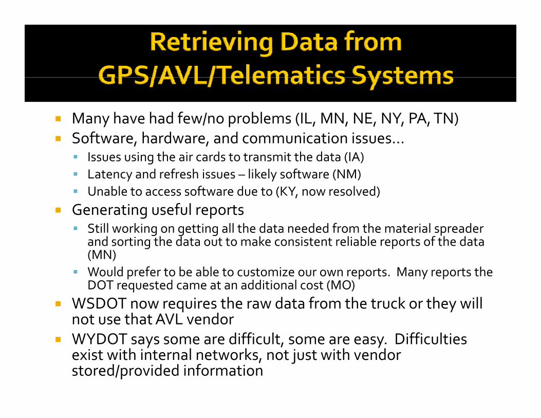
Many have had few/no problems (IL, MN, NE, NY, PA, TN) Software, hardware, and communication issues… Issues using the air cards to transmit the data (IA) Latency and refresh issues – likely software (NM) Unable to access software due to (KY, now resolved)
Generating useful reports Still working on getting all the data needed from the material spreader g g g p
and sorting the data out to make consistent reliable reports of the data (MN)
Would prefer to be able to customize our own reports. Many reports the DOT requested came at an additional cost (MO)DOT requested came at an additional cost (MO)
WSDOT now requires the raw data from the truck or they will not use that AVL vendor
WYDOT says some are difficult some are easy Difficulties WYDOT says some are difficult, some are easy. Difficulties exist with internal networks, not just with vendor stored/provided information
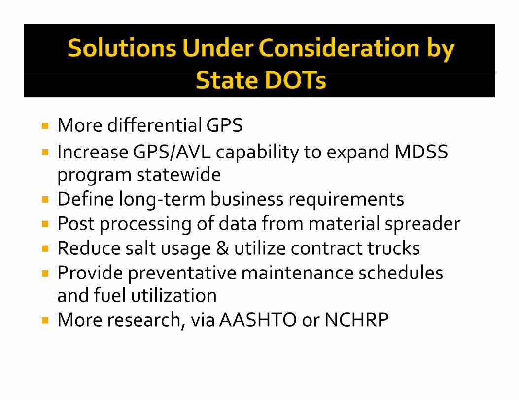
More differential GPS More differential GPS Increase GPS/AVL capability to expand MDSS program statewideprogram statewide
Define long‐term business requirements Post processing of data from material spreader Post processing of data from material spreader Reduce salt usage & utilize contract trucks Provide preventative maintenance schedules Provide preventative maintenance schedules and fuel utilization
More research, via AASHTO or NCHRPMore research, via AASHTO or NCHRP
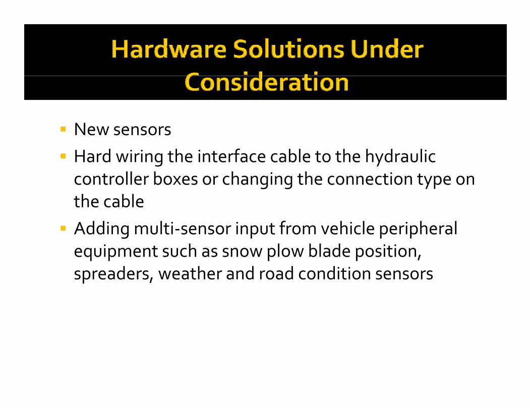
New sensors New sensors Hard wiring the interface cable to the hydraulic controller boxes or changing the connection type on controller boxes or changing the connection type on the cable Adding multi‐sensor input from vehicle peripheral Adding multi sensor input from vehicle peripheral equipment such as snow plow blade position, spreaders, weather and road condition sensorsp ,
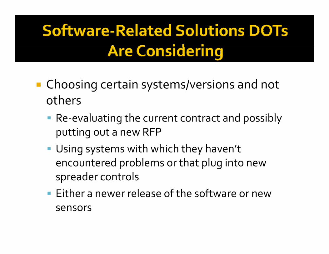
Choosing certain systems/versions and not others Re‐evaluating the current contract and possibly putting out a new RFP Using systems with which they haven’t encountered problems or that plug into new spreader controls spreader controls Either a newer release of the software or new sensorssensors
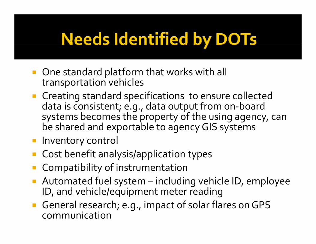
One standard platform that works with all ptransportation vehicles
Creating standard specifications to ensure collected data is consistent; e g data output from on‐board data is consistent; e.g., data output from on‐board systems becomes the property of the using agency, can be shared and exportable to agency GIS systemsI t t l Inventory control
Cost benefit analysis/application types Compatibility of instrumentation Compatibility of instrumentation Automated fuel system – including vehicle ID, employee
ID, and vehicle/equipment meter reading General research; e.g., impact of solar flares on GPS
communication
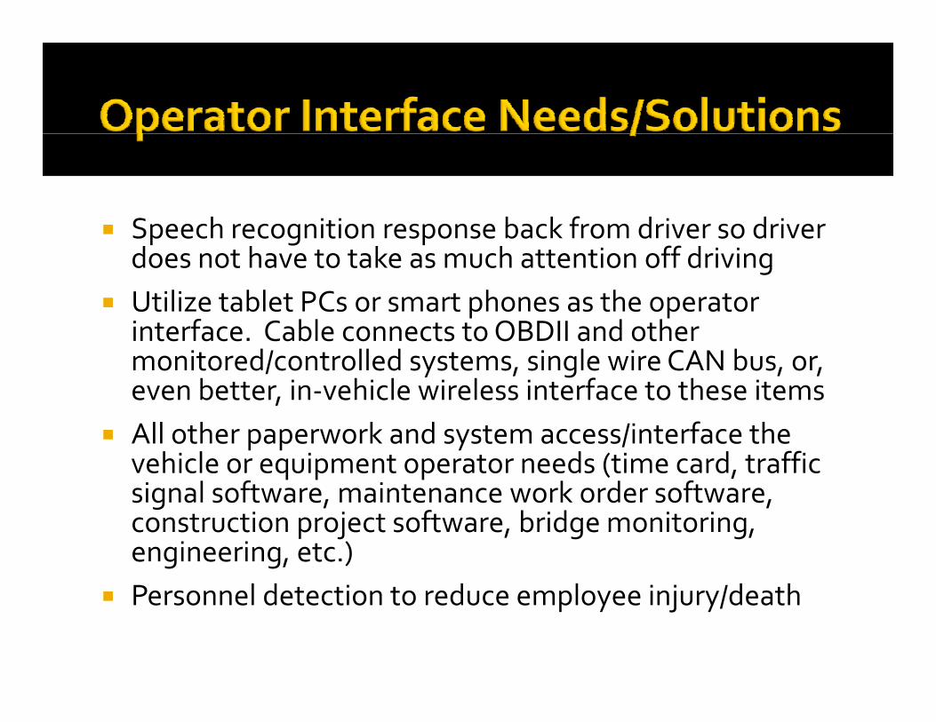
Speech recognition response back from driver so driver Speech recognition response back from driver so driver does not have to take as much attention off driving
Utilize tablet PCs or smart phones as the operator p pinterface. Cable connects to OBDII and other monitored/controlled systems, single wire CAN bus, or, even better, in‐vehicle wireless interface to these items
All other paperwork and system access/interface the vehicle or equipment operator needs (time card, traffic signal software maintenance work order software signal software, maintenance work order software, construction project software, bridge monitoring, engineering, etc.)P l d t ti t d l i j /d th Personnel detection to reduce employee injury/death
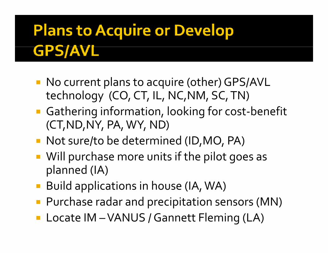
N t l t i ( th ) GPS/AVL No current plans to acquire (other) GPS/AVL technology (CO, CT, IL, NC,NM, SC, TN)
Gathering information looking for cost benefit Gathering information, looking for cost‐benefit (CT,ND,NY, PA, WY, ND)
Not sure/to be determined (ID MO PA) Not sure/to be determined (ID,MO, PA) Will purchase more units if the pilot goes as planned (IA) p ( )
Build applications in house (IA, WA) Purchase radar and precipitation sensors (MN)p p ( ) Locate IM –VANUS / Gannett Fleming (LA)
Trimble in conjunction with a mobile weather detection Trimble in conjunction with a mobile weather detection system (AK)
Component Tech / Cirus (DE)p ( ) Road/Air temperature, and Relative Humidity sensors
from Vaisala (MN)T i bl /U i it f Mi t d RFID (AK) Trimble/University of Minnesota and RFID (AK)
Network Fleet (VA) Force/Precise Location Technologies (WY) Force/Precise, Location Technologies (WY) Intelligent Devices Inc ‐ future MDSS applications (ID) AmeriTrak (MN)AmeriTrak (MN) HELP Truck –Courtesy Patrol AVL (NY)
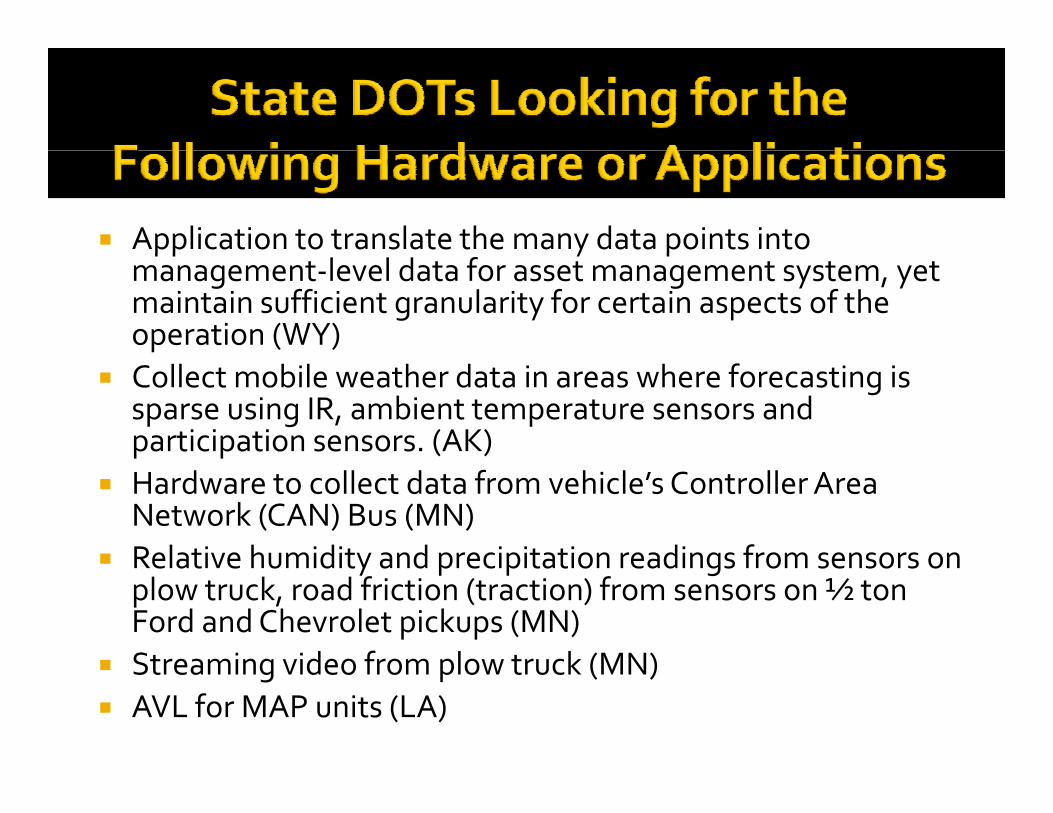
Application to translate the many data points into pp y pmanagement‐level data for asset management system, yet maintain sufficient granularity for certain aspects of the operation (WY)
Collect mobile weather data in areas where forecasting is sparse using IR, ambient temperature sensors and participation sensors. (AK)p p
Hardware to collect data from vehicle’s Controller Area Network (CAN) Bus (MN)
Relative humidity and precipitation readings from sensors on Relative humidity and precipitation readings from sensors on plow truck, road friction (traction) from sensors on ½ ton Ford and Chevrolet pickups (MN)
Streaming video from plow truck (MN) Streaming video from plow truck (MN) AVL for MAP units (LA)
Winter Operations Winter Operations GPS Truck Tracking and Material GPS Truck Tracking and Material
UsageUsageUsageUsage
Tom Clay
Washington State Department of Transportation
Western States Equipment Conference
8-31-2011
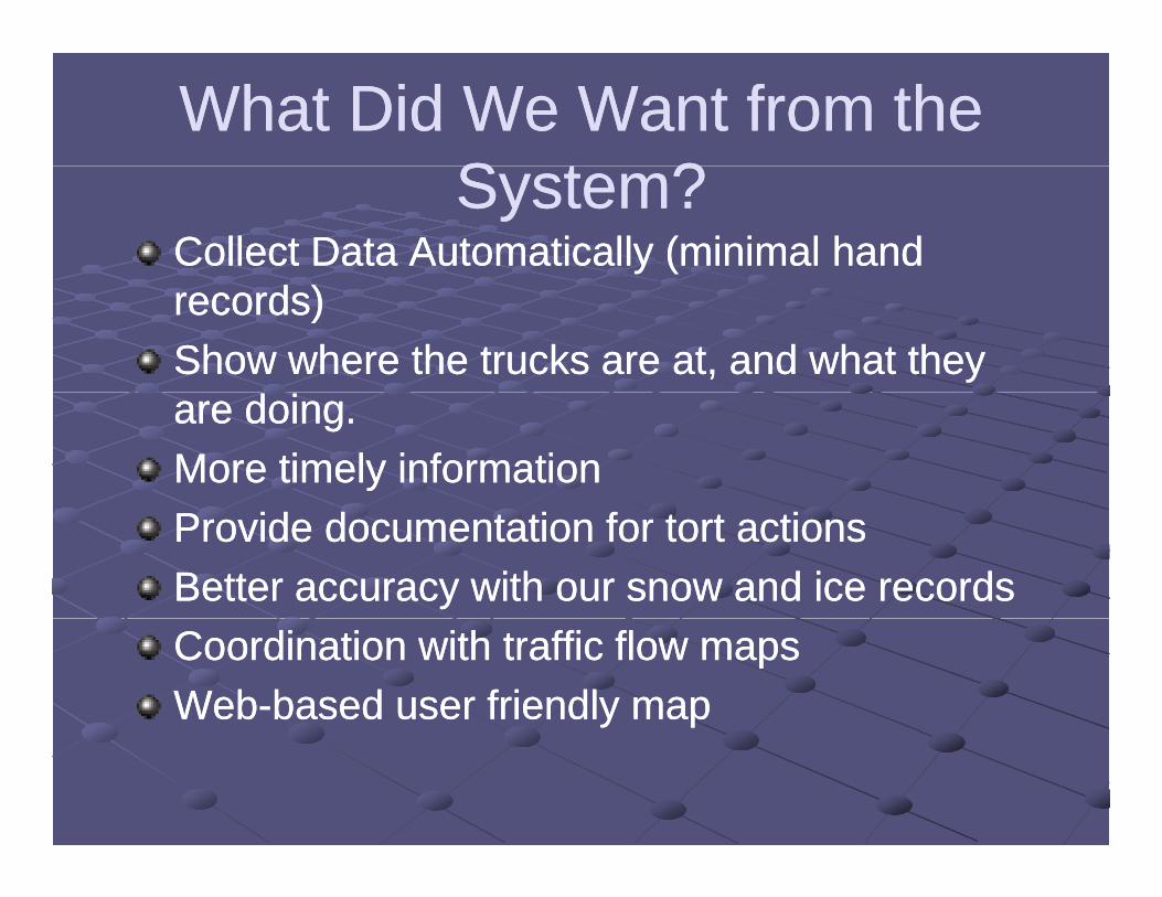
What Did We Want from the What Did We Want from the S t ?S t ?System?System?
Collect Data Automatically (minimal hand Collect Data Automatically (minimal hand records)records)Show where the trucks are at, and what they Show where the trucks are at, and what they are doing.are doing.More timely informationMore timely informationProvide documentation for tort actionsProvide documentation for tort actionsBetter accuracy with our snow and ice recordsBetter accuracy with our snow and ice recordsCoordination with traffic flow mapsCoordination with traffic flow mapsWebWeb--based user friendly mapbased user friendly map
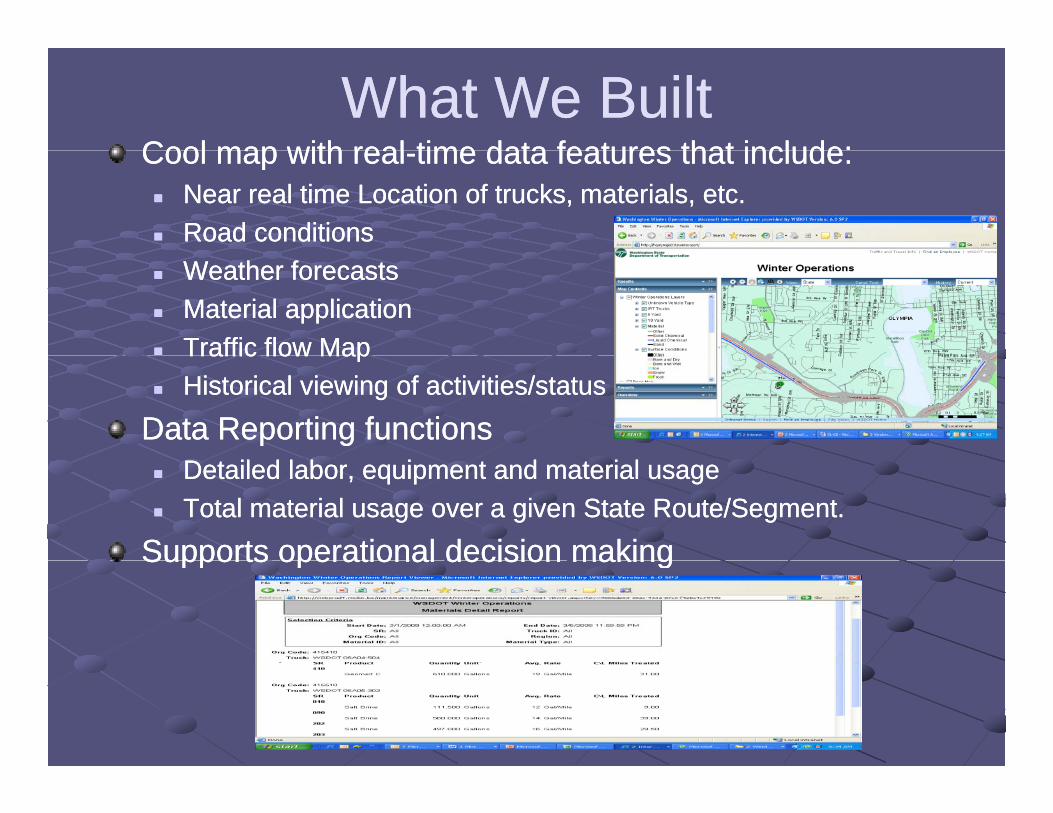
What We BuiltWhat We BuiltCool map with realCool map with real time data features that include:time data features that include:Cool map with realCool map with real--time data features that include:time data features that include: Near real time Location of trucks, materials, etc.Near real time Location of trucks, materials, etc. Road conditionsRoad conditions Weather forecastsWeather forecasts Material applicationMaterial application Traffic flow MapTraffic flow MapTraffic flow MapTraffic flow Map Historical viewing of activities/statusHistorical viewing of activities/status
Data Reporting functionsData Reporting functions Detailed labor, equipment and material usageDetailed labor, equipment and material usage Total material usage over a given State Route/Segment.Total material usage over a given State Route/Segment.
Supports operational decision makingSupports operational decision makingSupports operational decision makingSupports operational decision making
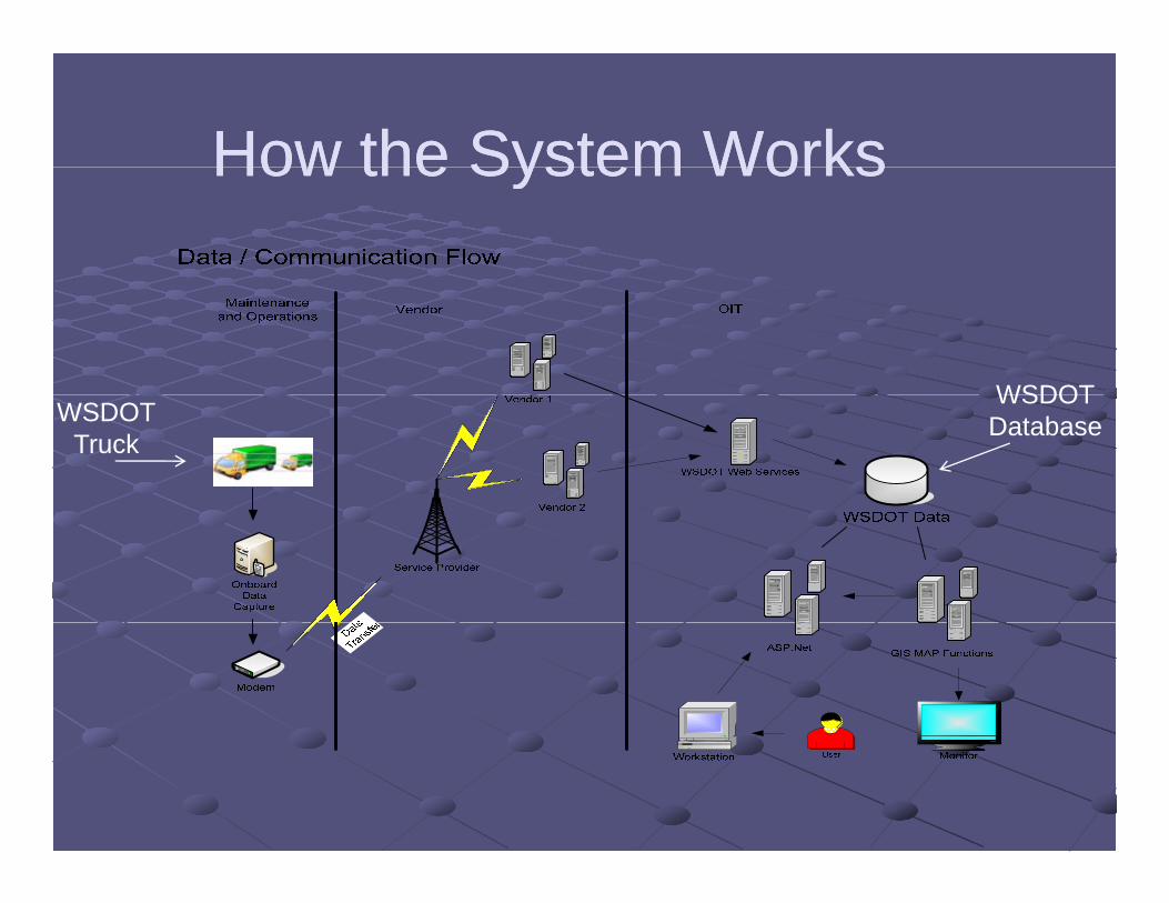
How the System WorksHow the System WorksHow the System Works How the System Works
WSDOTWSDOT
Truck
WSDOTDatabase
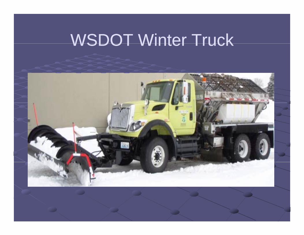
WSDOT Winter TruckWSDOT Winter TruckWSDOT Winter Truck WSDOT Winter Truck
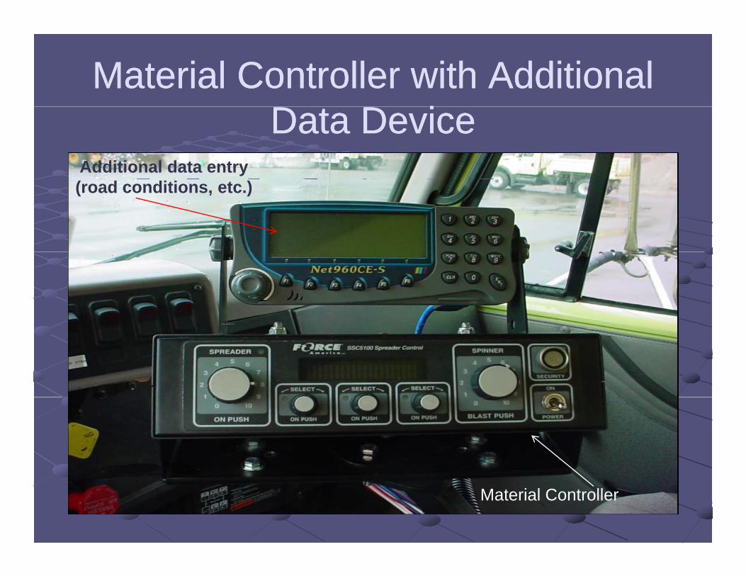
Material Controller with Additional Material Controller with Additional D D iD D iData DeviceData Device
Additional data entry(road conditions, etc.)
Material Controller

NS200 VS Precision ControllerNS200 VS Precision ControllerNS200 VS Precision ControllerNS200 VS Precision Controller
At 23 MPH truck applies 326 lbs per L/MAt 23 MPH truck applies 326 lbs per L/MCoves 61 miles with 20,000 lbs of saltCoves 61 miles with 20,000 lbs of salt39 miles short of 100 mile section39 miles short of 100 mile section12,714 lbs of additional material per 100 miles=$76212,714 lbs of additional material per 100 miles=$762

Current Implementation CostsCurrent Implementation CostsCurrent Implementation CostsCurrent Implementation Costs
20,000 lane miles to maintain20,000 lane miles to maintain20,000 lane miles to maintain20,000 lane miles to maintain480 trucks available in WSDOT fleet480 trucks available in WSDOT fleet
Currently 245 trucks setup and reporting to the Currently 245 trucks setup and reporting to the system (50%)system (50%)system (50%).system (50%).Truck Hardware Costs ……….$1,960,000Truck Hardware Costs ……….$1,960,000Monthly data charges $7 300Monthly data charges $7 300Monthly data charges……………...$7,300Monthly data charges……………...$7,300Total cost for the development of the SQL Total cost for the development of the SQL database and Web GIS system $200 000database and Web GIS system $200 000database and Web GIS system $200,000database and Web GIS system $200,000
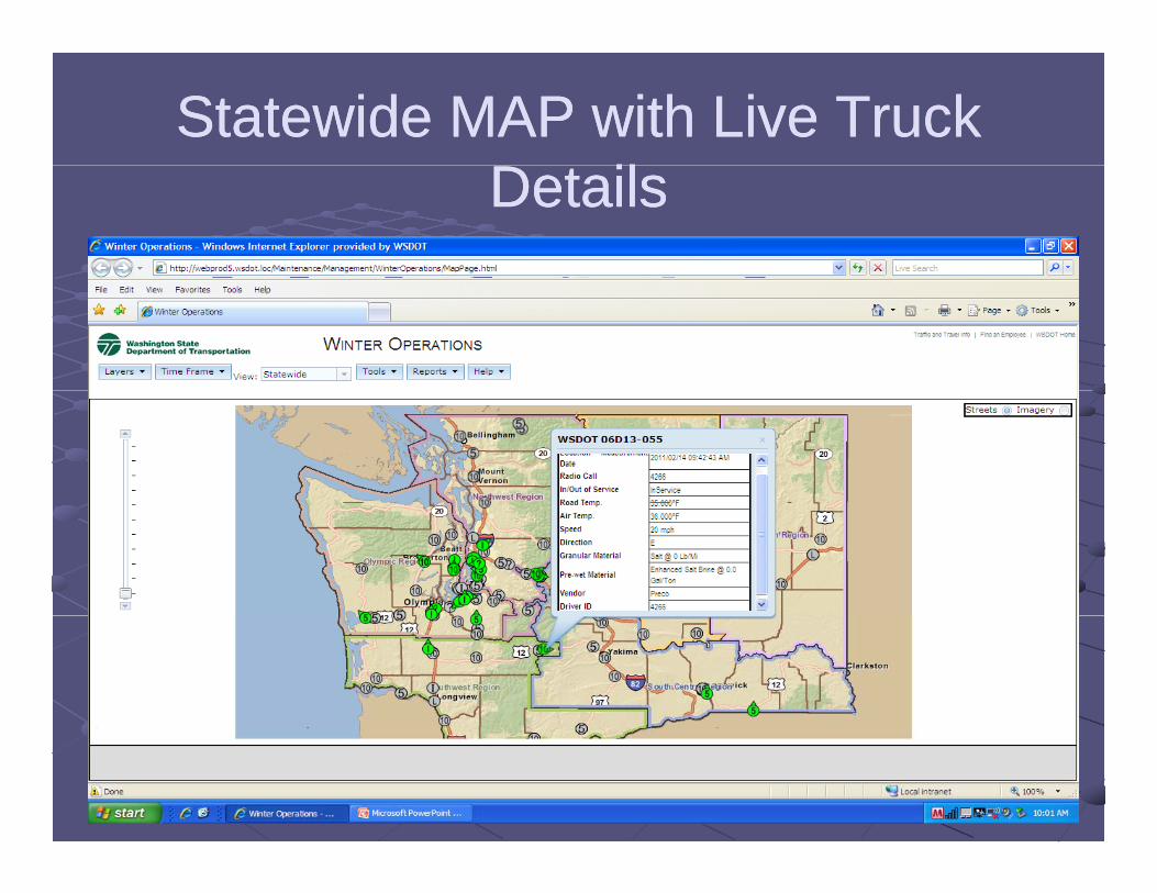
Statewide MAP with Live Truck Statewide MAP with Live Truck D ilD ilDetailsDetails
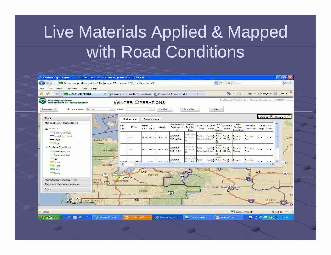
Live Materials Applied & Mapped Live Materials Applied & Mapped ith R d C ditiith R d C ditiwith Road Conditionswith Road Conditions
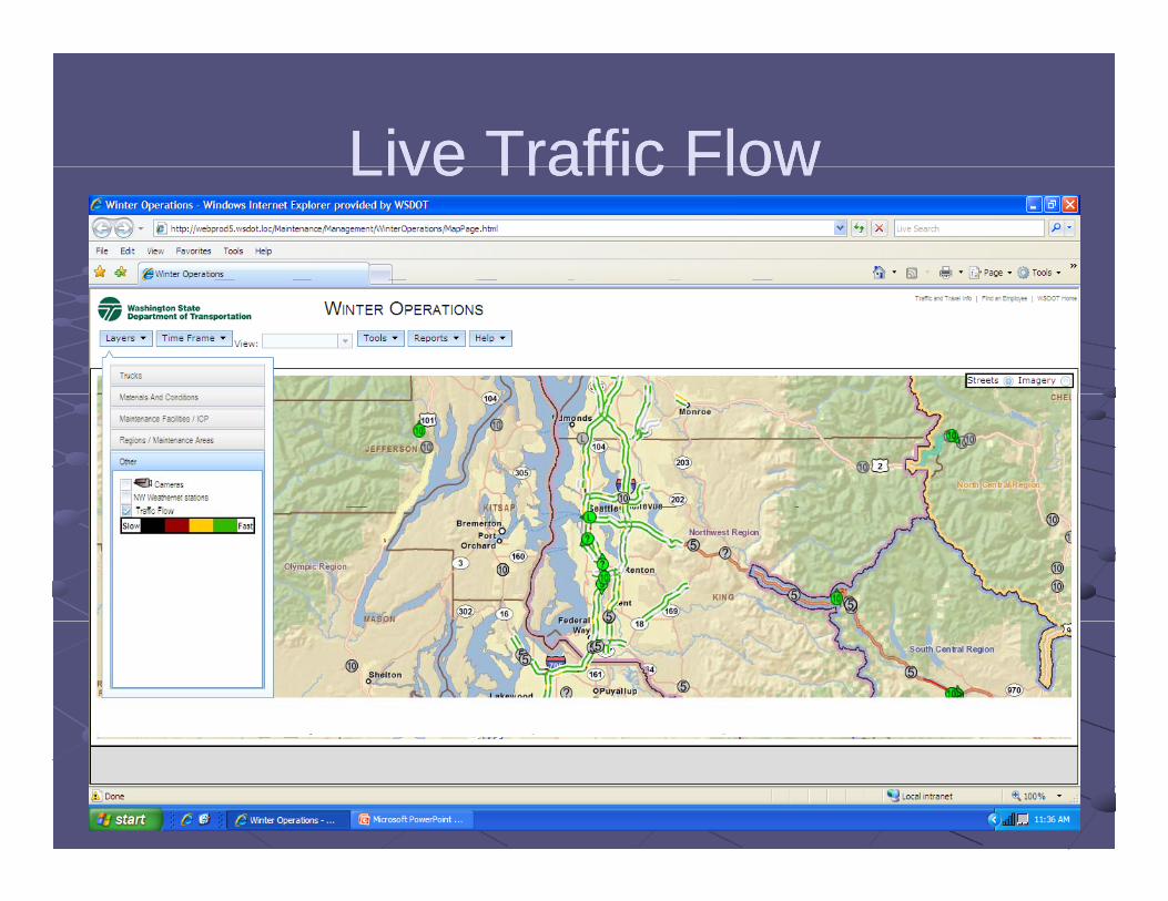
Live Traffic FlowLive Traffic FlowLive Traffic Flow Live Traffic Flow
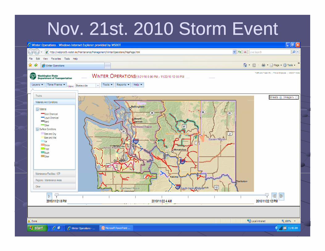
Nov. 21st. 2010 Storm Event Nov. 21st. 2010 Storm Event St t idSt t idStatewideStatewide
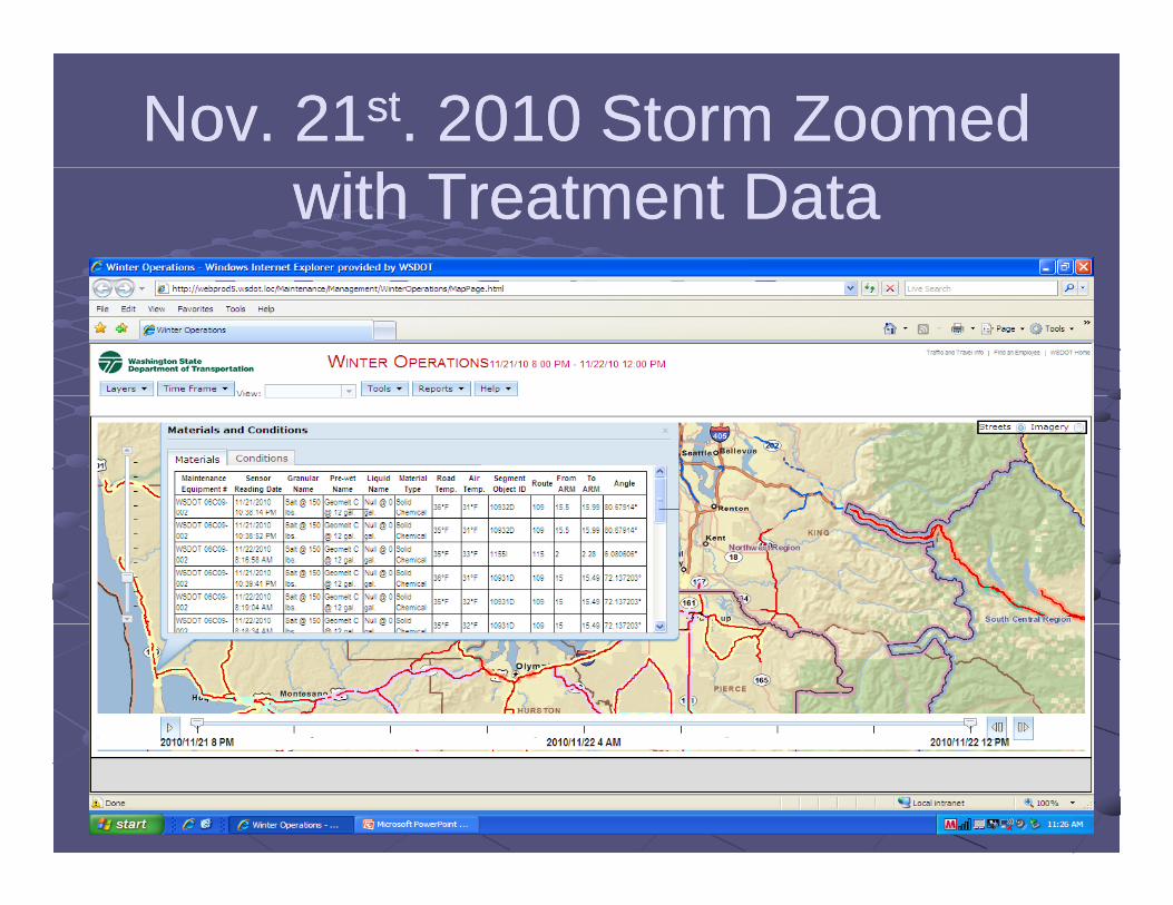
Nov. 21Nov. 21stst. 2010 Storm Zoomed . 2010 Storm Zoomed with Treatment Data with Treatment Data
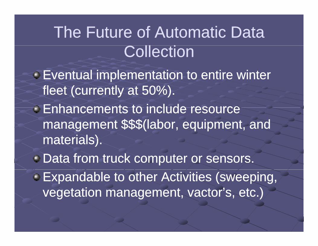
The Future of Automatic Data The Future of Automatic Data C ll iC ll iCollectionCollection
Eventual implementation to entire winterEventual implementation to entire winterEventual implementation to entire winter Eventual implementation to entire winter fleet (currently at 50%).fleet (currently at 50%).Enhancements to include resourceEnhancements to include resourceEnhancements to include resource Enhancements to include resource management $$$(labor, equipment, and management $$$(labor, equipment, and materials)materials)materials).materials).Data from truck computer or sensors.Data from truck computer or sensors.Expandable to other Activities (sweeping, Expandable to other Activities (sweeping, vegetation management, vactor’s, etc.)vegetation management, vactor’s, etc.)

Questions?Questions?
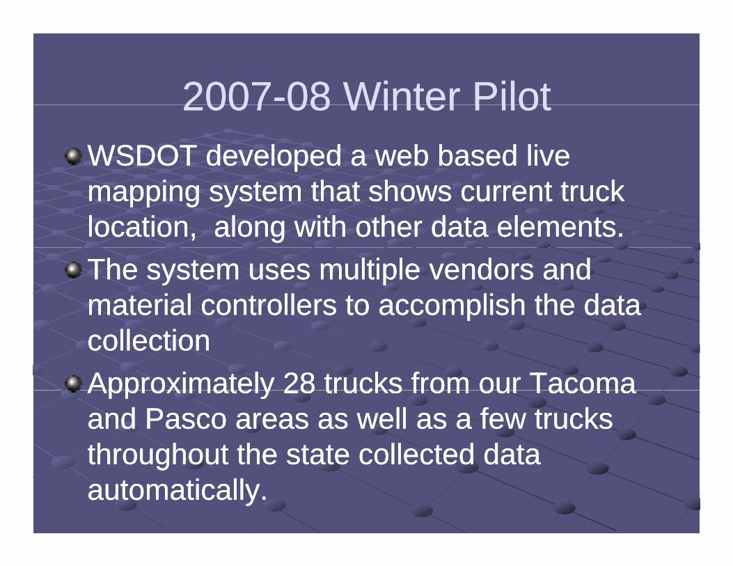
20072007--08 Winter Pilot08 Winter Pilot20072007 08 Winter Pilot08 Winter PilotWSDOT developed a web based live WSDOT developed a web based live mapping system that shows current truck mapping system that shows current truck location, along with other data elements. location, along with other data elements. The system uses multiple vendors and The system uses multiple vendors and material controllers to accomplish the data material controllers to accomplish the data ppcollectioncollectionApproximately 28 trucks from our TacomaApproximately 28 trucks from our TacomaApproximately 28 trucks from our Tacoma Approximately 28 trucks from our Tacoma and Pasco areas as well as a few trucks and Pasco areas as well as a few trucks throughout the state collected datathroughout the state collected datathroughout the state collected data throughout the state collected data automatically.automatically.
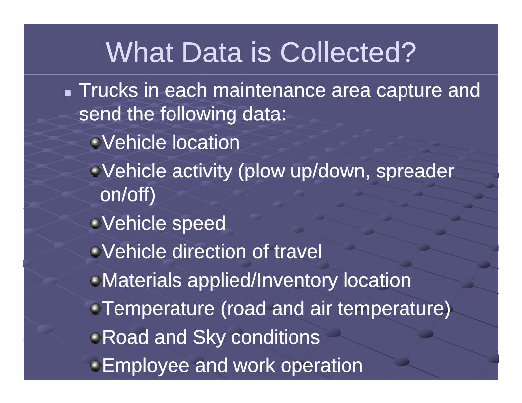
What Data is Collected?What Data is Collected? Trucks in each maintenance area capture and Trucks in each maintenance area capture and
send the following data:send the following data:Vehicle locationVehicle locationVehicle activity (plow up/down, spreaderVehicle activity (plow up/down, spreaderVehicle activity (plow up/down, spreader Vehicle activity (plow up/down, spreader on/off)on/off)Vehicle speedVehicle speedVehicle speedVehicle speedVehicle direction of travelVehicle direction of travelMaterials applied/Inventory locationMaterials applied/Inventory locationMaterials applied/Inventory locationMaterials applied/Inventory locationTemperature (road and air temperature)Temperature (road and air temperature)Road and Sky conditionsRoad and Sky conditionsEmployee and work operationEmployee and work operation
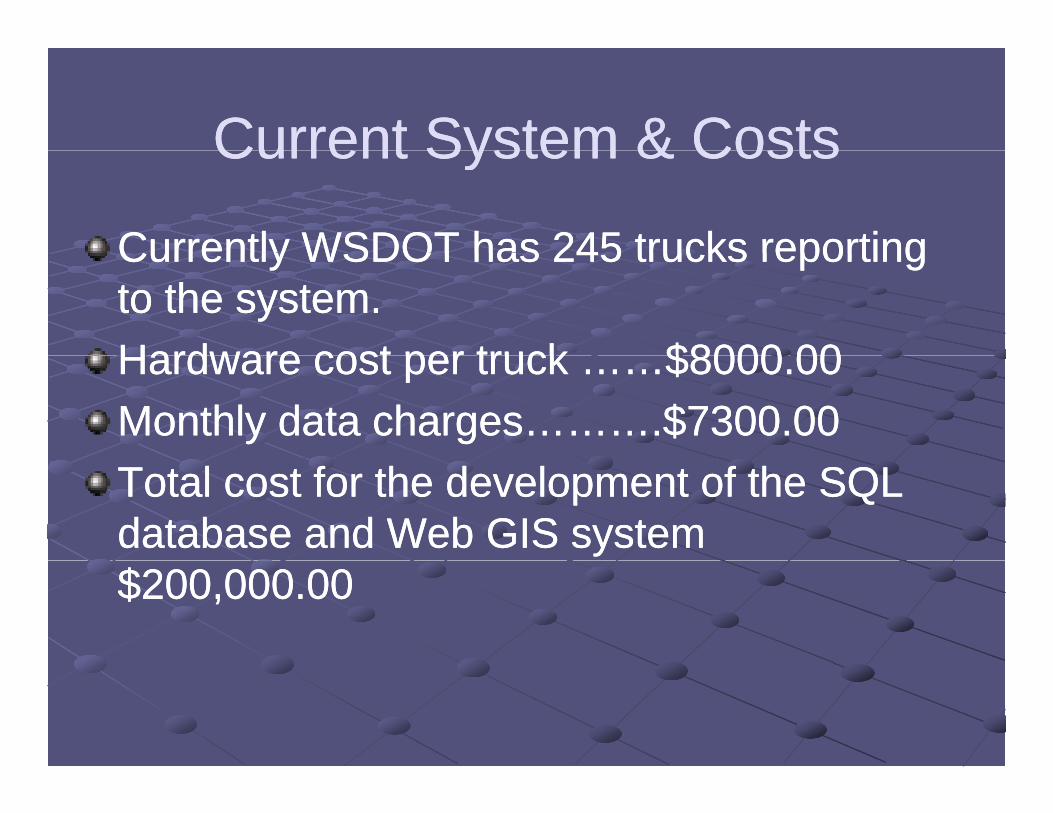
Current System & CostsCurrent System & CostsCurrent System & CostsCurrent System & Costs
Currently WSDOT has 245 trucks reportingCurrently WSDOT has 245 trucks reportingCurrently WSDOT has 245 trucks reporting Currently WSDOT has 245 trucks reporting to the system.to the system.Hardware cost per truck $8000 00Hardware cost per truck $8000 00Hardware cost per truck ……$8000.00Hardware cost per truck ……$8000.00Monthly data charges……….$7300.00Monthly data charges……….$7300.00Total cost for the development of the SQL Total cost for the development of the SQL database and Web GIS system database and Web GIS system $200,000.00$200,000.00
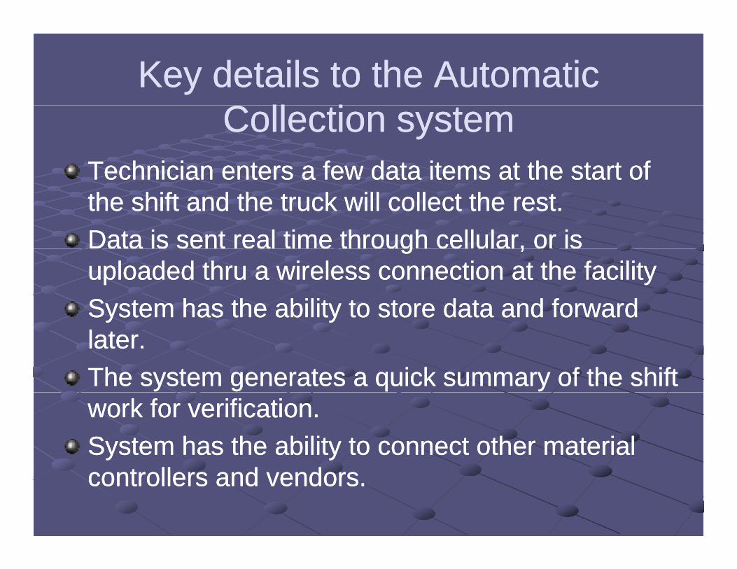
Key details to the Automatic Key details to the Automatic C ll iC ll iCollection systemCollection system
Technician enters a few data items at the start ofTechnician enters a few data items at the start ofTechnician enters a few data items at the start of Technician enters a few data items at the start of the shift and the truck will collect the rest.the shift and the truck will collect the rest.Data is sent real time through cellular, or is Data is sent real time through cellular, or is g ,g ,uploaded thru a wireless connection at the facilityuploaded thru a wireless connection at the facilitySystem has the ability to store data and forward System has the ability to store data and forward y yy ylater.later.The system generates a quick summary of the shift The system generates a quick summary of the shift work for verification.work for verification.System has the ability to connect other material System has the ability to connect other material controllers and vendors.controllers and vendors.
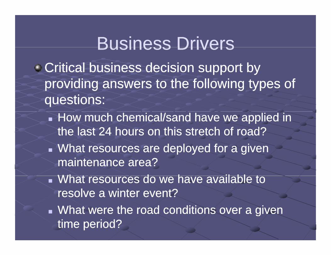
Business DriversBusiness DriversBusiness DriversBusiness DriversCritical business decision support by Critical business decision support by
idi t th f ll i t fidi t th f ll i t fproviding answers to the following types of providing answers to the following types of questions:questions: How much chemical/sand have we applied in How much chemical/sand have we applied in
the last 24 hours on this stretch of road?the last 24 hours on this stretch of road?ff What resources are deployed for a given What resources are deployed for a given
maintenance area?maintenance area?Wh t d h il bl tWh t d h il bl t What resources do we have available to What resources do we have available to resolve a winter event?resolve a winter event?What were the road conditions over a givenWhat were the road conditions over a given What were the road conditions over a given What were the road conditions over a given time period?time period?
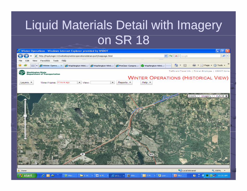
Liquid Materials Detail with Imagery Liquid Materials Detail with Imagery SR 18SR 18on SR 18on SR 18